Appendix 4: Southwest Site Summaries
|
|
|
- Percival Barnett
- 5 years ago
- Views:
Transcription
1 Appendix 4: Southwest Site Summaries to accompany Update to a 1992 assessment of Florida s remaining coastal upland natural communities Ann F. Johnson, PhD and Kimberely Gulledge December 2005 Florida Natural Areas Inventory 1018 Thomasville Road Tallahassee, FL Report in fulfillment of DEP Agreement No. G0088 pursuant to U.S. Department of Commerce Federal Grant Agreement No. NA03NOS

2 Levy County LEVY-01 Cedar Keys National Wildlife Refuge Islands North of Cedar Key LEVY-02 Cedar Keys National Wildlife Refuge North Key LEVY-03 Cedar Keys National Wildlife Refuge Atsena Otie Key LEVY-04 Cedar Keys National Wildlife Refuge Seahorse Key SOUTHWEST SITE LOCATIONS Map Kilometers
3 PASC-01 Anclote Key Preserve State Park Pasco County PINE-01 Anclote Key Preserve State Park "Three-Rooker Bar" Hillsborough County PINE-02 Honeymoon Island State Park PINE-03 Caladesi Island State Park PINE-04 Sand Key Park Pinellas County PINE-05 Treasure Island PINE-06 Shell Key Preserve (formerly Bunces Pass Islands) PINE-08 Fort Desoto Park PINE-07 Fort Desoto Park - Mullet Key SOUTHWEST SITE LOCATIONS Map 2 HILL-01 Egmont Key Manatee County Kilometers MANA-01 Beer Can Island SARA-01 North Lido Public Beach SARA-02 South Lido County Park SARA-03 Palmer Point County Park (formerly Midnight Pass) Sarasota County SARA-04 Caspersen Beach County Park SARA-05 Manasota Key Hammocks
4 CHAR-01 Stump Pass Beach State Park (formerly Port Charlotte SRA) CHAR-02 Knight Island and Thornton Key Charlotte County CHAR-03 Don Pedro Island State Park LEE-01a Gasparilla Island State Park LEE-03 Cayo Costa State Park LEE-05 Cayo Costa State Park North Captiva Island LEE-02 Cayo Costa State Park Point Blanco Island LEE-01 Pine Island NWR Patricio Island LEE-04 Cabbage Key LEE-06 Charlotte Harbor Preserve State Park Josselyn Island Lee County LEE-07 J. N. Ding Darling NWR (Buck Key) LEE-08 Sanibel-Captiva Conservation Foundation Lands Wulfert Hammock LEE-10 Sanibel Island Lighthouse LEE-11 San Carlos Bay Bunch Beach Preserve LEE-09 J. N. Ding Darling NWR LEE-12 Estero Island Sandspit LEE-13 Lovers Key State Park COLL-01 Barefoot Beach Preserve COLL-02 Delnor-Wiggins Pass State Park Collier County SOUTHWEST SITE LOCATIONS Map 3 COLL-04 Rookery Bay NER Keewaydin Island COLL-03 Vanderbilt Beach COLL-08 Sand Dollar Island and Tiger Tail Beach COLL-05 Rookery Bay NER Arthur Godfrey Island COLL-06 Rookery Bay NER Little Marco Island COLL-07 Rookery Bay NER Cannon Island Kilometers COLL-09 Hideaway Beach COLL-10 Rookery Bay NER Cape Romano COLL-11 Ten Thousand Islands NWR Shell Key COLL-12 Ten Thousand Islands NWR Dismal Key COLL-13 Ten Thousand Islands NWR Whitehorse Key
5 Monroe County Dade County MONR-59 Everglades National Park Northwest Cape Sable MONR-60 Everglades National Park Middle Cape Sable MONR-61 Everglades National Park East Cape Sable DADE-09 Everglades National Park North Florida Bay Hammocks SOUTHWEST SITE LOCATIONS Map Kilometers
6 Southwest Region Summary Table Site: Total 1992 na Total 2005 natural acres: Total developed since original Total in public ownership* 1992: Total in public ownership* 2005: Total natural remaining outside public ownership: Public owner: Managed by: Managed Area name(s): LEVY State of Florida; USFWS FL-DEP (DRP); USFWS Cedar Key Scrub State Preserve; Cedar Keys National Wildlife Refuge; Lower Suwannee National Wildlife Refuge LEVY State of Florida; USFWS State of Florida; USFWS Cedar Keys National Wildlife Refuge LEVY USFWS USFWS Cedar Keys National Wildlife Refuge LEVY USFWS USFWS Cedar Keys National Wildlife Refuge PASC State of Florida FL-DEP (DRP) Anclote Key Preserve State Park PINE State of Florida FL-DEP (DRP) Anclote Key Preserve State Park PINE State of Florida FL-DEP (DRP) Honeymoon Island State Park PINE State of Florida FL-DEP (DRP) Caladesi Island State Park PINE Pinellas County Pinellas County Sand Key Park PINE TIITF City of Treasure island NA PINE State of Florida; Pinellas Pinellas County Shell Key Preserve County PINE Pinellas County Pinellas County Fort Desoto Park PINE Pinellas County Pinellas County Fort Desoto Park HILL USFWS; US Coast FL-DEP (DRP) Egmont Key Guard MANA Manatee County Manatee County NA SARA City of Sarasota Sarasota County North Lido Public Beach * only natural acres included Page 1
7 Southwest Region Summary Table Site: Total 1992 na Total 2005 natural acres: Total developed since original Total in public ownership* 1992: Total in public ownership* 2005: Total natural remaining outside public ownership: Public owner: Managed by: Managed Area name(s): SARA Sarasota County Sarasota County South Lido County Park SARA Sarasota County Sarasota County Palmer Point County Park SARA US; Sarasota County; City of Venice Sarasota County Caspersen Beach County Park; Brohard Park SARA NA NA NA CHAR State of Florida; The FL-DEP (DRP); The Stump Pass Beach State Nature Conservancy (non-naturprofitprofit) Conservancy (non- Park; Cook Memorial Preserve CHAR NA NA NA CHAR State of Florida FL-DEP (DRP) Don Pedro Island State Park LEE USFWS USFWS Pine Island National Wildlife Refuge LEE-01a State of Florida FL-DEP (DRP) Gasparilla Island State Park LEE State of Florida FL-DEP (DRP) Cayo Costa State Park LEE State of Florida; Lee FL-DEP (DRP) Cayo Costa State Park County LEE NA NA NA LEE State of Florida FL-DEP (DRP) Cayo Costa State Park LEE State of Florida State of Florida; SWFWMD Charlotte Harbor Preserve State Park LEE State of Florida; USFWS; Sanibel-Captiva J. N. Ding Darling USFWS; Sanibel-Captiva Conservation Foundation Conservation Foundation (non-profit) (non-profit) National Wildlife Refuge; Sanibel-Captiva Conservation Foundation Lands (Buck Key) * only natural acres included Page 2
8 Southwest Region Summary Table Site: Total 1992 na Total 2005 natural acres: Total developed since original Total in public ownership* 1992: Total in public ownership* 2005: LEE Sanibel-Captiva Conservation Foundation (non-profit) Total natural remaining outside public ownership: Public owner: Managed by: Managed Area name(s): Sanibel-Captiva Sanibel-Captiva Conservation Foundation Conservation Foundation (non-profit) Lands LEE State of Florida; USFWS USFWS J. N. Ding Darling National Wildlife Refuge LEE USFWS USFWS Sanibel Island Lighthouse (HQ for Ding Darling NWR) LEE US; Lee County Lee County San Carlos Bay Bunche Beach Preserve LEE State of Florida State of Florida NA LEE State of Florida; Lee FL-DEP (DRP) Lovers Key State Park County COLL Collier County; State of Florida (leased to county) Collier County Barefoot Beach Preserve COLL State of Florida FL-DEP (DRP) Delnor-Wiggins Pass State Park COLL Collier County Collier County NA COLL State of Florida; The Conservancy of Southwest Florida (nonprofit) COLL National Audubon Society FL-DEP (CAMA) FL-DEP (CAMA) Rookery Bay National Estuarine Research Reserve (Keewaydin) Rookery Bay National Estuarine Research Reserve (Arthur Godfrey Island) * only natural acres included Page 3
9 Southwest Region Summary Table Site: Total 1992 na Total 2005 natural acres: Total developed since original Total in public ownership* 1992: Total in public ownership* 2005: Total natural remaining outside public ownership: Public owner: Managed by: Managed Area name(s): COLL State of Florida FL-DEP (CAMA) Rookery Bay National Estuarine Research Reserve (Little Marco Island) COLL State of Florida; The Conservancy of Southwest Florida (nonprofit) COLL State of Florida; Collier County FL-DEP (CAMA) Collier County? Rookery Bay National Estuarine Research Reserve (Cannon Island) Tigertail Beach COLL NA NA NA COLL State of Florida FL-DEP (CAMA) Rookery Bay National Estuarine Research Reserve (Cape Romano) COLL USFWS USFWS Ten Thousand Islands National Wildlife Refuge (Shell Key) COLL USFWS USFWS Ten Thousand Islands National Wildlife Refuge (Dismal Key) COLL State of Florida USFWS Ten Thousand Islands National Wildlife Refuge (Whitehorse Key) MONR US National Park Service US National Park Service Everglades National Park (Northwest Cape Sable) MONR US National Park Service US National Park Service Everglades National Park (Middle Cape Sable) MONR US National Park Service US National Park Service Everglades National Park (East Cape Sable) * only natural acres included Page 4
10 Southwest Region Summary Table Site: Total 1992 na Total 2005 natural acres: Total developed since original Total in public ownership* 1992: Total in public ownership* 2005: Total natural remaining outside public ownership: Public owner: Managed by: Managed Area name(s): DADE US National Park Service US National Park Service Everglades National Park (North Florida Bay Hammocks) TOTAL * only natural acres included Page 5
11 Site Summaries
12 LEVY-1 Cedar Keys National Wildlife Refuge (Islands North of Cedar Key) Original DOT Aerial: NA 2004 DOQQ: q4225ne, nw, se, sw Total 1992 natural acres (corrected in 2005): Total 2005 natural acres: Total developed since original report: 0 Total in public ownership* 1992: Total in public ownership* 2005: Total natural remaining in private ownership*: 31.2 Public owner: State of Florida; USFWS Managed by: FL-DEP (DRP); USFWS Managed Area name(s): Cedar Key Scrub State Preserve; Cedar Keys National Wildlife Refuge; Lower Suwannee National Wildlife Refuge Site not re-surveyed. [Evaluation based on interpretation of 2004 true color DOQQ aerial photography at 1m resolution.] 1992 Plant Communities: maritime hammock (A) shell mound (A) xeric hammock (A) 2005 Plant Communities (no change) Comments: amended since original survey to include substantially more acreage. Rare species: no change in FNAI database. Site rank: A

13

14
15 LEVY-2 Cedar Keys National Wildlife Refuge (North Key) Original DOT Aerial: (11/30/90) PD DOQQ: q4125nw; q4225sw Total 1992 natural acres (corrected in 2005): 49.4 Total 2005 natural acres: 49.4 Total developed since original report: 0 Total in public ownership* 1992: 49.4 Total in public ownership* 2005: 49.4 Total natural remaining in private ownership*: 0 Public owner: State of Florida; USFWS Managed by: State of Florida; USFWS Managed Area name(s): Cedar Keys National Wildlife Refuge Site not re-surveyed. [Evaluation based on interpretation of 2004 true color DOQQ aerial photography at 1m resolution.] 1992 Plant Communities: beach dune (B) maritime hammock (A) 2005 Plant Communities (no change) Comments: Rare species: no change in FNAI database Site rank: A

16
17 LEVY-3 Cedar Keys National Wildlife Refuge (Atsena Otie Key) Original DOT Aerial: (11/30/90) PD DOQQ: q4125ne; q4225se Total 1992 natural acres (corrected in 2005): 43.9 Total 2005 natural acres: 43.9 Total developed since original report: 0 Total in public ownership* 1992: 0 Total in public ownership* 2005: 43.9 Total natural remaining in private ownership*: 0 Public owner: USFWS Managed by: USFWS Managed Area name(s): Cedar Keys National Wildlife Refuge Site not re-surveyed. [Evaluation based on interpretation of 2004 true color DOQQ aerial photography at 1m resolution.] 1992 Plant Communities: beach dune (B) xeric hammock (B) mesic flatwoods (B) 2005 Plant Communities (no change) Comments: Rare species: Haliaeetus leucocephalus, Nerodia clarkii clarkii, Pandion haliaetus added to FNAI database. Site rank: B

18
19 LEVY-4 Cedar Keys National Wildlife Refuge (Seahorse Key) Original DOT Aerial: (11/30/90) PD DOQQ: q4125ne, nw Total 1992 natural acres (corrected in 2005): 66.8 Total 2005 natural acres: 66.8 Total developed since original report: 0 Total in public ownership* 1992: 66.8 Total in public ownership* 2005: 66.8 Total natural remaining in private ownership*: 0 Public owner: USFWS Managed by: USFWS Managed Area name(s): Cedar Keys National Wildlife Refuge Site not re-surveyed. [Evaluation based on interpretation of 2004 true color DOQQ aerial photography at 1m resolution.] 1992 Plant Communities: beach dune (B) maritime hammock (B) 2005 Plant Communities (no change) Comments: Rare species: no change in FNAI database. Site rank: B

20
21 PASC-1 Anclote Key Preserve State Park (Anclote Key) Original DOT Aerial: (4/7/88) PD3723-1A-03, 1A DOQQ: q3423nw, sw Total 1992 natural acres (corrected in 2005): Total 2005 natural acres: Total developed since original report: 0 Total in public ownership* 1992: Total in public ownership* 2005: Total natural remaining in private ownership*: 36.4 Public owner: State of Florida Managed by: FL-DEP (DRP) Managed Area name(s): Anclote Key Preserve State Park Site not re-surveyed. [Evaluation based on interpretation of 2004 true color DOQQ aerial photography at 1m resolution.] 1992 Plant Communities: beach dune (A) maritime hammock (B) mesic flatwoods (B) 2005 Plant Communities (no change) Comments: Australian pine (Casuarina equisetifolia) still prevalent on north end of island. Rare species: Dendroica discolor paludicola, Charadrius alexandrinus, Charadrius melodus, Haematopus palliatus, Sterna antillarum added to FNAI database. Site rank: A

22
23 PINE-1 Anclote Key Preserve State Park (Three-Rooker Bar) Original DOT Aerial: (12/4/86) PD DOQQ: q3323nw; q3423sw Total 1992 natural acres (corrected in 2005): 98.5 Total 2005 natural acres: 98.5 Total developed since original report: 0 Total in public ownership* 1992: 98.5 Total in public ownership* 2005: 98.5 Total natural remaining in private ownership*: 0 Public owner: State of Florida Managed by: FL-DEP (DRP) Managed Area name(s): Anclote Key Preserve State Park Site not re-surveyed. [Evaluation based on interpretation of 2004 true color DOQQ aerial photography at 1m resolution.] 1992 Plant Communities: beach dune (A) 2005 Plant Communities (no change) Comments: colonizing Australian pine (Casuarina equisetifolia) removed from island by AmeriCorps volunteers in Rare species: Haematopus palliatus, Rynchops niger, Sterna antillarum, Sterna sandvicensis, Sterna caspia added to FNAI database. Site rank: A

24
25 PINE-2 Honeymoon Island State Park Original DOT Aerial: (12/4/86) PD , DOQQ: q3323nw, sw Total 1992 natural acres (corrected in 2005): Total 2005 natural acres: Total developed since original report: 0 Total in public ownership* 1992: Total in public ownership* 2005: Total natural remaining in private ownership*: 0 Public owner: State of Florida Managed by: FL-DEP (DRP) Managed Area name(s): Honeymoon Island State Park Site not re-surveyed. [Evaluation based on interpretation of 2004 true color DOQQ aerial photography at 1m resolution.] 1992 Plant Communities: beach dune (B) mesic flatwoods (B) 2004 Plant Communities: beach dune (A): area substantially increased by natural accretion. mesic flatwoods (B) Comments: newly deposited outer fork has extended 0.6 mi north since original study, substantially increasing the area in natural condition at this site. It is important to keep Australian pine (Casuarina equisetifolia) from gaining a foothold in this area. The nonindigenous beach sunflower (Helianthus debilis ssp. debilis), once planted around buildings, has been removed in favor of the species native to this coast (Helianthus debilis ssp. vestitus). Rare species: Gopherus polyphemus, Crotalus adamanteus, Haematopus palliatus, Rynchops niger, Sterna antillarum, Sterna caspia, Sterna maxima added to FNAI database. Site rank: A

26
27 PINE-3 Caladesi Island State Park Original DOT Aerial: (12/4/86) PD , DOQQ: q3323sw; q3223nw Total 1992 natural acres (corrected in 2005): Total 2005 natural acres: Total developed since original report: 0 Total in public ownership* 1992: Total in public ownership* 2005: Total natural remaining in private ownership*: 71.9 Public owner: State of Florida Managed by: FL-DEP (DRP) Managed Area name(s): Caladesi Island State Park Site not re-surveyed. [Evaluation based on interpretation of 2004 true color DOQQ aerial photography at 1m resolution.] 1992 Plant Communities: beach dune (B) coastal grassland (A) maritime hammock (A) 2005 Plant Communities (no change) Comments: city of Clearwater may own a portion of area mapped as in private ownership south of Caladesi Island where old Dunedin Pass was filled in precise ownership information unavailable at this time. Rare species: Acrostichum aureum, Charadrius melodus, Haematopus palliatus, Sterna antillarum added to FNAI database. Site rank: A

28
29 PINE-4 Sand Key Park Original DOT Aerial: (12/4/86) PD DOQQ: q3223nw Total 1992 natural acres (corrected in 2005): 33.5 Total 2005 natural acres: 33.5 Total developed since original report: 0 Total in public ownership* 1992: 33.5 Total in public ownership* 2005: 33.5 Total natural remaining in private ownership*: 0 Public owner: Pinellas County Managed by: Pinellas County Managed Area name(s): Sand Key Park Site not re-surveyed. [Evaluation based on interpretation of 2004 true color DOQQ aerial photography at 1m resolution.] 1992 Plant Communities: beach dune (B) 2005 Plant Communities (no change) Comments: Rare species: no change in FNAI database Site rank: B

30
31 PINE-5 Treasure Island Original DOT Aerial: (3/20/91) PD3953-4H DOQQ: q3123se Total 1992 natural acres (corrected in 2005): Total 2005 natural acres: Total developed since original report: 0 Total in public ownership* 1992: Total in public ownership* 2005: Total natural remaining in private ownership*: 0 Public owner: State of Florida Managed by: City of Treasure Island Managed Area name(s): NA Site not re-surveyed. [Evaluation based on interpretation of 2004 true color DOQQ aerial photography at 1m resolution ] 1992 Plant Communities: beach dune (C) 2005 Plant Communities (no change) Comments: Rare species: no change in FNAI database Site rank: C

32
33 PINE-6 Shell Key Preserve (formerly Bunces Pass Islands) Original DOT Aerial: (12/4/86) PD DOQQ: q3022sw Total 1992 natural acres (corrected in 2005): Total 2005 natural acres: Total developed since original report: 0 Total in public ownership* 1992: Total in public ownership* 2005: Total natural remaining in private ownership*: 0 Public owner: State of Florida; Pinellas County Managed by: Pinellas County Managed Area name(s): Shell Key Preserve Site not re-surveyed. [Evaluation based on interpretation of 2004 true color DOQQ aerial photography at 1m resolution.] 1992 Plant Communities: beach dune (A) 2005 Plant Communities (no change). Comments: three islands have joined into one long island since original report; Australian pine (Casuarina equisetifolia) seems to be maintaining a foothold at the southern end and eventually could colonize the entire island. Rare species: Sterna antillarum added to FNAI database. Site rank: A

34
35 PINE-7 Fort Desoto Park (Mullet Key) Original DOT Aerial: (12/4/86) PD DOQQ: q3022sw; q2922nw Total 1992 natural acres (corrected in 2005): Total 2005 natural acres: Total developed since original report: 0 Total in public ownership* 1992: Total in public ownership* 2005: Total natural remaining in private ownership*: 0 Public owner: Pinellas County Managed by: Pinellas County Managed Area name(s): Fort Desoto Park Site not re-surveyed. [Evaluation based on interpretation of 2004 true color DOQQ aerial photography at 1m resolution.] 1992 Plant Communities: beach dune (B) maritime hammock (B) 2005 Plant Communities (no change) Comments: outer fork of beach has broken into three pieces and changed position since original report. Rare species: Charadrius melodus, Sterna antillarum, Sterna maxima, Sterna sandvicensis added to FNAI database Site rank: B

36
37 PINE-8 Fort Desoto Park Original DOT Aerial: (12/4/86) PD DOQQ: q3022sw; q2922nw Total 1992 natural acres (corrected in 2005): Total 2005 natural acres: Total developed since original report: 0 Total in public ownership* 1992: Total in public ownership* 2005: Total natural remaining in private ownership*: 0 Public owner: Pinellas County Managed by: Pinellas County Managed Area name(s): Fort Desoto Park Site not re-surveyed. [Evaluation based on interpretation of 2004 true color DOQQ aerial photography at 1m resolution.] 1992 Plant Communities: beach dune (C) maritime hammock (C) 2005 Plant Communities (no change) Comments: Rare species: no change in FNAI database. Site rank: C

38
39 HILL-1 Egmont Key Original DOT Aerial: (4/1/87) PD DOQQ: q2923ne Total 1992 natural acres (corrected in 2005): Total 2005 natural acres: Total developed since original report: 0 Total in public ownership* 1992: Total in public ownership* 2005: Total natural remaining in private ownership*: 0 Public owner: USFWS; US Coast Guard Managed by: FL-DEP (DRP) Managed Area name(s): Egmont Key Site not re-surveyed. [Evaluation based on interpretation of 2004 true color DOQQ aerial photography at 1m resolution.] 1992 Plant Communities: beach dune (A) coastal grassland (B) coastal strand (B) maritime hammock (C) 2005 Plant Communities (no change) Comments: Rare species: Crotalus adamanteus, Haematopus palliatus added to FNAI database Site rank: B/C

40
41 MANA-1 Beer Can Island Original DOT Aerial: (4/1/87) PD DOQQ: q2822nw, sw, se Total 1992 natural acres (corrected in 2005): 44.7 Total 2005 natural acres: 44.7 Total developed since original report: 0 Total in public ownership* 1992: 5.3 Total in public ownership* 2005: 5.3 Total natural remaining in private ownership*: 39.4 Public owner: Manatee County Managed by: Manatee County Managed Area name(s): NA Site not re-surveyed. [Evaluation based on interpretation of 2004 true color DOQQ aerial photography at 1m resolution.] 1992 Plant Communities: beach dune (C) coastal interdunal swale (B) maritime hammock (C) 2005 Plant Communities (no change) Comments: This highly changeable coastline near inlet has eroded about 500 feet since original report. Parcel data is incomplete for portion outside county ownership and includes mostly private lots. Rare species: no change in FNAI database Site rank: C

42
43 SARA-1 North Lido Public Beach Original DOT Aerial: (1/12/90) PD DOQQ: q2721nw Total 1992 natural acres (corrected in 2005): 68.4 Total 2005 natural acres: 68.4 Total developed since original report: 0 Total in public ownership* 1992: 68.4 Total in public ownership* 2005: 68.4 Total natural remaining in private ownership*: 0 Public owner: City of Sarasota Managed by: Sarasota County Managed Area name(s): North Lido Public Beach Site not re-surveyed. [Evaluation based on interpretation of 2004 true color DOQQ aerial photography at 1m resolution.] 1992 Plant Communities: beach dune (B) maritime hammock (C) 2005 Plant Communities (no change) Comments: beach has eroded in north and built out to south since original report. Rare species: no change in FNAI Site rank: C

44
45 SARA-2 South Lido County Park Original DOT Aerial: (1/12/90) PD DOQQ: q2721sw Total 1992 natural acres (corrected in 2005): 23.4 Total 2005 natural acres: 23.4 Total developed since original report: 0 Total in public ownership* 1992: 23.4 Total in public ownership* 2005: 23.4 Total natural remaining in private ownership*: 0 Public owner: Sarasota County Managed by: Sarasota County Managed Area name(s): South Lido County Park Site not re-surveyed. Change agent: hurricane impact (exotic plant removal) [Evaluation based on interpretation of 2004 true color DOQQ aerial photography at 1m resolution.] 1992 Plant Communities: beach dune (B) coastal interdunal swale (B) 1992 Plant Communities: beach dune (B) coastal interdunal swale (X): eroded away Comments: tip of Lido Key eroded back about 0.25 mi since original report; Australian pines (Casuarina equisetifolia) still prominent in this park. Rare species: no change in FNAI database Site rank: C

46
47 SARA-3 Palmer Point County Park (formerly Midnight Pass) Original DOT Aerial: (1/13/90) PD DOQQ: q2621ne Total 1992 natural acres (corrected in 2005): 57.8 Total 2005 natural acres: 46.8 Total developed since original report: 11.0 Total in public ownership* 1992: 26.5 Total in public ownership* 2005: 26.5 Total natural remaining in private ownership*: 20.3 Public owner: Sarasota County Managed by: Sarasota County Managed Area name(s): Palmer Point County Park Site not re-surveyed. [Evaluation based on interpretation of 2004 true color DOQQ aerial photography at 1m resolution.] 1992 Plant Communities: beach dune (B) maritime hammock (C) 2005 Plant Communities (no change) beach dune (B): solid herbaceous ground cover appears to have replaced widely scattered pioneer plants. maritime hammock (C): mostly developed. Comments: Rare species: no change in FNAI database Site rank: C

48
49 SARA-4 Caspersen Beach County Park Original DOT Aerial: (1/13/90) PD , DOQQ: q2520nw, sw, se Total 1992 natural acres (corrected in 2005): 83.2 Total 2005 natural acres: 83.2 Total developed since original report: 0 Total in public ownership* 1992: 83.2 Total in public ownership* 2005: 83.2 Total natural remaining in private ownership*: 0 Total restored acres: 4.5 Public owner: US; Sarasota County; City of Venice Managed by: Sarasota County Managed Area name(s): Caspersen Beach County Park; Brohard Park Site not re-surveyed. [Evaluation based on interpretation of 2004 true color DOQQ aerial photography at 1m resolution.] 1992 Plant Communities: scrub (A) maritime hammock (B) 2005 Plant Communities (no change) Comments: Rare species: no change in FNAI database Site rank: B

50
51 SARA-5 Manasota Key Hammocks Original DOT Aerial: (1/13/90) PD , DOQQ: q2420ne; q2419nw Total 1992 natural acres (corrected in 2005): 67.4 Total 2005 natural acres: 51.9 Total developed since original report: 15.5 Total in public ownership* 1992: 0 Total in public ownership* 2005: 0 Total natural remaining in private ownership*: 51.9 Public owner: NA Managed by: NA Managed Area name(s): NA Site not re-surveyed. [Evaluation based on interpretation of 2004 true color DOQQ aerial photography at 1m resolution.] 1992 Plant Communities: maritime hammock (B) 2005 Plant Communities [no change] Comments: Rare species: no change in FNAI database. Site rank: B

52
53 CHAR-1 Stump Pass Beach State Park (formerly Port Charlotte State Recreation Area) Original DOT Aerial: (4/8/88) PD DOQQ: q2419sw Total 1992 natural acres (corrected in 2005): Total 2005 natural acres: Total developed since original report: 0 Total in public ownership* 1992: (includes non-profit) Total in public ownership* 2005: (includes non-profit) Total natural remaining in private ownership*: 0 Public owner: State of Florida; The Nature Conservancy (non-profit) Managed by: FL-DEP (DRP); The Nature Conservancy (non-profit) Managed Area name(s): Stump Pass Beach State Park; Cook Memorial Preserve Site not re-surveyed. [Evaluation based on interpretation of 2004 true color DOQQ aerial photography at 1m resolution.] 1992 Plant Communities: beach dune (B) coastal strand (C) maritime hammock (A) 2005 Plant Communities (no change). Comments: Australian pine slated for removal (park biologist, 2005). Rare species: no change in FNAI database Site rank: B

54
55 CHAR-2 Knight Island and Thornton Key Original DOT Aerial: (4/8/88) PD DOQQ: q2419sw Total 1992 natural acres (corrected in 2005): Total 2005 natural acres: Total developed since original report: 11.5 Total in public ownership* 1992: 0 Total in public ownership* 2005: 0 Total natural remaining in private ownership*: Public owner: NA Managed by: NA Managed Area name(s): NA Site not re-surveyed. [Evaluation based on interpretation of 2004 true color DOQQ aerial photography at 1m resolution.] 1992 Plant Communities: beach dune (A) coastal grassland (A) coastal strand (B) maritime hammock (A) 2005 Plant Communities (no change) Comments: a large portion of hammock on inner barrier island was added that was missed in original report; exclusive resort area on a highly changeable coastline near inlet. Rare species: no change in FNAI database Site rank: B

56
57 CHAR-3 Don Pedro Island State Park Original DOT Aerial: (4/8/88) PD DOQQ: q2319ne Total 1992 natural acres (corrected in 2005): Total 2005 natural acres: Total developed since original report: 31.8 Total in public ownership* 1992: Total in public ownership* 2005: Total natural remaining in private ownership*: 53.8 Public owner: State of Florida Managed by: FL-DEP (DRP) Managed Area name(s): Don Pedro Island State Park Site re-surveyed on 18 November 2005 by Mark Tancig. Change agent: exotic plant removal 1992 Plant Communities: beach dune (B) coastal grassland (A) maritime hammock (C) 2005 Plant Communities beach dune (B) has a steep 8 scarp eroded during the hurricane season, decreasing the area of this community. coastal grassland (A): scattered Australian pine (Casuarina equisetifolia) and Brazilian pepper (Schinus terebinthifolius) have been removed, but other exotics [lantana (Lantana camara) and natal grass (Rhynchelytrum repens)] are found infrequently throughout this community. maritime hammock (C): heavy invasion of Australian pine (Casuarina equisetifolia) and Brazilian pepper (Schinus terebinthifolius) has been mostly removed, however, Brazilian pepper is still present in small quantities; an open canopy of cabbage palm (Sabal palmetto) along with sea grape (Coccoloba uvifera) and wax-myrtle (Myrica cerifera) is present. Comments: the pattern of accretion/erosion is erosion along the length of the island, resulting in a narrowing of most of the length of the island and accretion at the southern tip, resulting in a larger area of beach dune community. Rare species: Gopher tortoises (Gopherus polyphemus) are present throughout the coastal grassland community, and a pair of bald eagles (Haliaeetus leucocephalus) was observed in a dead Australian pine snag in coastal grassland near the southern end of the property. Site rank: B

58
59 LEE-1 Pine Island National Wildlife Refuge (Patricio Island) Original DOT Aerial: NA 2004 DOQQ: q2218nw, sw Total 1992 natural acres (corrected in 2005): 21.1 Total 2005 natural acres: 21.1 Total developed since original report: 0 Total in public ownership* 1992: 21.1 Total in public ownership* 2005: 21.1 Total natural remaining in private ownership*: 0 Public owner: USFWS Managed by: USFWS Managed Area name(s): Pine Island National Wildlife Refuge Site not re-surveyed. [Evaluation based on interpretation of 2004 true color DOQQ aerial photography at 1m resolution.] 1992 Plant Communities: maritime hammock (B) 2005 Plant Communities (no change) Comments: Rare species: no change in FNAI database. Site rank: B

60
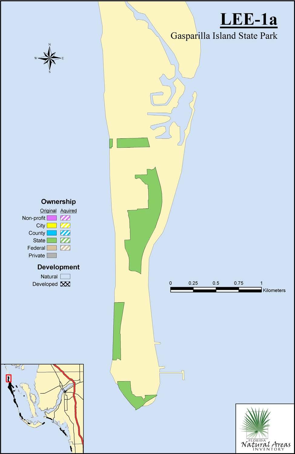
61 LEE-1a Gasparilla Island State Park Original DOT Aerial: NA 2004 DOQQ: q2219ne Total 1992 natural acres (corrected in 2005): 90.0 Total 2005 natural acres: 90.0 Total developed since original report: 0 Total in public ownership* 1992: 90.0 Total in public ownership* 2005: 90.0 Total natural remaining in private ownership*: 0 Public owner: State of Florida Managed by: FL-DEP (DRP) Managed Area name(s): Gasparilla Island State Park NEW SITE Surveyed on 17 November 2005 by Mark Tancig. Physical setting: narrow barrier island.25 to.5 mile wide in this stretch. Plant communities: beach dune, coastal strand, maritime hammock beach dune (B): the southern tip of the island has a scarp that ranges from 3 around parking area to 7 at extreme tip, south of lighthouse, and is dominated by sea oats (Uniola paniculata) with hurricane grass (Fimbristylis cymosa), prickly pear (Opuntia humifusa), sea grapes (Coccoloba uvifera), beachberry (Scaevola plumieri), and dune sunflower (Helianthus debilis) also present. The beach dune under park ownership along the western side of the island has a scarp that ranges from 7 at the southern beach area, to 4 at the northern beach area. These beach dunes are dominated by sea oats with seacoast marshelder (Iva imbricata), knotgrass (Paspalum distichum) and the species listed above. coastal strand (C): a narrow strip of coastal strand occurs on the southern beach on the west side of the island and consists of cabbage palm (Sabal palmetto), sea grapes, Brazilian pepper (Schinus terebinthifolius), buttonwood (Conocarpus erectus), gumbolimbo (Simarouba glauca), leadtree (Leucaena leucophylla), spanish bayonet (Yucca aloifolia), beggarticks (Bidens alba), hurricane grass, southern beeblossom (Gaura angustifolia), climbing hempvine (Mikania scandens), narrowleaf yellowtops (Flaveria linearis), railroad vine (Ipomoea pes-caprae), and nicker bean (Caesalpinia bonduc). maritime hammock (B): maritime hammock occurs on the park property that is east of CR 771. The 30 canopy is dominated by cabbage palm and sea grapes with gumbolimbo and strangler fig (Ficus aurea). Shrubs include marlberry (Ardisia escallonioides), lead tree, Brazilian pepper, wild coffee (Psychotria nervosa), snowberry (Chiococca alba), wax myrtle (Myrica cerifera), and white indigoberry (Randia aculeata). Herbs include Madagascar periwinkle (Catharanthus roseus) and rougeplant (Rivina humilis). Poison ivy (Toxicodendron radicans) is common throughout the area. Rare species: prickly apple-cactus (Harrisia aboriginum)-found in north end of hammock along ecotone between maritime hammock and high estuarine tidal swamp. Disturbance: Beach dune has been artificially built up and/or altered, and pavilions are present at northern beach. Coastal strand contains Brazilian pepper, lead tree, and Australian pine, and abuts CR-771. Brazilian pepper and lead tree are frequent throughout the hammock, and mother in laws tongue (Sansevieria hyacinthoides), weeping fig (Ficus benjamina), and creeping oxeye (Sphagneticola trilobata) are found infrequently. Iguanas observed. Surrounding land use: residential; water Site rank: B/C
62
63 LEE-2 Cayo Costa State Park (formerly Point Blanco Island) Original DOT Aerial: NA 2004 DOQQ: q2218nw, sw Total 1992 natural acres (corrected in 2005): 57.6 Total 2005 natural acres: 57.6 Total developed since original report: 0 Total in public ownership* 1992: 57.6 Total in public ownership* 2005: 57.6 Total natural remaining in private ownership*: 0 Public owner: State of Florida Managed by: FL-DEP (DRP) Managed Area name(s): Cayo Costa State Park Site not re-surveyed. [Evaluation based on interpretation of 2004 true color DOQQ aerial photography at 1m resolution.] 1992 Plant Communities: coastal strand (B) maritime hammock (B) 2005 Plant Communities (no change) Comments: Rare species: no change in FNAI database Site rank: B

64
65 LEE-3 Cayo Costa State Park Original DOT Aerial: (1/13/90) PD , 01-04, 02-05, DOQQ: q2118nw; q2218nw, sw; q2219ne, se Total 1992 natural acres (corrected in 2005): Total 2005 natural acres: Total developed since original report: 4.2 Total in public ownership* 1992: Total in public ownership* 2005: Total natural remaining in private ownership*: 49.7 Total acres with exotics removed: 83.4 Public owner: State of Florida; Lee County Managed by: FL-DEP (DRP) Managed Area name(s): Cayo Costa State Park Site re-surveyed in August 2005 by Mike Jenkins. Change agent: exotic plant removal [Evaluation also based on interpretation of 2004 true color DOQQ aerial photography at 1m resolution.] 1992 Plant Communities: beach dune (A) coastal grassland (A) coastal strand (A) maritime hammock (A) mesic flatwoods (B) 2005 Plant Communities (no change) beach dune (A) coastal grassland (A): Australian pine being removed from large stand near the Gulf coast coastal strand (A) maritime hammock (A) mesic flatwoods (B) Comments: Rare species: Lantana depressa var floridana not seen in brief visit. Site rank: A

66

67

68
69 LEE-4 Cabbage Key Original DOT Aerial: (1/13/90) PD DOQQ: q2218sw Total 1992 natural acres (corrected in 2005): 13.9 Total 2005 natural acres: 13.9 Total developed since original report: 0 Total in public ownership* 1992: 0 Total in public ownership* 2005: 0 Total natural remaining in private ownership*: 13.9 Public owner: NA Managed by: NA Managed Area name(s): NA Site not re-surveyed. [Evaluation based on interpretation of 2004 true color DOQQ aerial photography at 1m resolution.] 1992 Plant Communities: maritime hammock (B) 2005 Plant Communities (no change) maritime hammock (B): several more houses built since original report thought still mostly natural. Comments: Rare species: no change in FNAI database Site rank: B

70
71 LEE-5 Cayo Costa State Park (formerly North Captiva Island) Original DOT Aerial: (1/13/90) PD DOQQ: q2118nw, sw Total 1992 natural acres (corrected in 2005): Total 2005 natural acres: Total developed since original report: 32.1 Total in public ownership* 1992: Total in public ownership* 2005: Total natural remaining in private ownership*: 29.9 Public owner: State of Florida Managed by: FL-DEP (DRP) Managed Area name(s): Cayo Costa State Park Site not re-surveyed. Change agent: hurricane impact [Evaluation based on interpretation of 2004 true color DOQQ aerial photography at 1m resolution.] 1992 Plant Communities: beach dune (A) coastal grassland (A) coastal strand (A) maritime hammock (B) 2005 Plant Communities (no change). Comments: narrow portion that had been recently overwashed at time of 1990 visit was broken through by Hurricane Charlie, which stuck the area on 13 August Rare species: no change in FNAI database Site rank: A

72
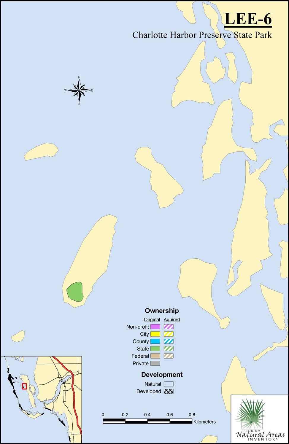
73 LEE-6 Charlotte Harbor Preserve State Park (formerly Josselyn island) Original DOT Aerial: NA 2004 DOQQ: q2118ne Total 1992 natural acres (corrected in 2005): 4.9 Total 2005 natural acres: 4.9 Total developed since original report: 0 Total in public ownership* 1992: 4.9 Total in public ownership* 2005: 4.9 Total natural remaining in private ownership*: 0 Public owner: State of Florida Managed by: State of Florida; SWFWMD Managed Area name(s): Charlotte Harbor Preserve State Park Site not re-surveyed. [Evaluation based on interpretation of 2004 true color DOQQ aerial photography at 1m resolution.] 1992 Plant Communities: shell mound (A) 2005 Plant Communities (no change) Comments: Rare species: no change in FNAI database Site rank: A
74
75 LEE-7 J. N. Ding Darling National Wildlife Refuge (Buck Key) Original DOT Aerial: (1/13/90) PD DOQQ: q2118se; q2018ne Total 1992 natural acres (corrected in 2005): Total 2005 natural acres: Total developed since original report: 0 Total in public ownership* 1992: Total in public ownership* 2005: (including non-profit) Total natural remaining in private ownership*: 8.2 Public owner: State of Florida; USFWS; Sanibel-Captiva Conservation Foundation (non-profit) Managed by: USFWS; Sanibel-Captiva Conservation Foundation (non-profit) Managed Area name(s): J. N. Ding Darling National Wildlife Refuge; Sanibel-Captiva Conservation Foundation Lands Site not re-surveyed. [Evaluation based on interpretation of 2004 true color DOQQ aerial photography at 1m resolution.] 1992 Plant Communities: maritime hammock (A) 2005 Plant Communities (no change) Comments: Rare species: no change in FNAI database Site rank: A

76
77 LEE-8 Sanibel-Captiva Conservation Foundation Lands (Wulfert Hammock) Original DOT Aerial: (1/13/90) PD DOQQ: q2018ne Total 1992 natural acres (corrected in 2005): 43.4 Total 2005 natural acres: 2.8 Total developed since original report: 40.6 Total in public ownership* 1992: 2.8 (non-profit) Total in public ownership* 2005: 2.8 (non-profit) Total natural remaining in private ownership*: 0 Public owner: Sanibel-Captiva Conservation Foundation (non-profit) Managed by: Sanibel-Captiva Conservation Foundation (non-profit) Managed Area name(s): Sanibel-Captiva Conservation Foundation Lands Site not re-surveyed. [Evaluation based on interpretation of 2004 true color DOQQ aerial photography at 1m resolution.] 1992 Plant Communities: maritime hammock (B) 2005 Plant Communities (no change) Maritime hammock (C): largely converted to golf course with houses except for small parcel owned by non-profit organization. Comments: Rare species: no change in FNAI database Site rank: C

78
79 LEE-9 J. N. Ding Darling National Wildlife Refuge Original DOT Aerial: (1/13/90) PD DOQQ: q2018ne Total 1992 natural acres (corrected in 2005): Total 2005 natural acres: Total developed since original report: 0 Total in public ownership* 1992: Total in public ownership* 2005: Total natural remaining in private ownership*: 0 Public owner: State of Florida; USFWS Managed by: USFWS Managed Area name(s): J. N. Ding Darling National Wildlife Refuge Site not re-surveyed. [Evaluation based on interpretation of 2004 true color DOQQ aerial photography at 1m resolution.] 1992 Plant Communities: shell mound (B) maritime hammock (C) 2005 Plant Communities (no change) Comments: area expanded to encompass entire ridge according to 2004 DOQQ. Rare species: no change in FNAI database Site rank: B

80
81 LEE-10 Sanibel Island Lighthouse Original DOT Aerial: (1/14/90) PD DOQQ: q2017ne Total 1992 natural acres (corrected in 2005): 53.4 Total 2005 natural acres: 50.2 Total developed since original report: 3.2 Total natural in public ownership* 1992: 27.2 Total natural in public ownership* 2005: 24 Total natural remaining in private ownership*: 26.2 Public owner: USFWS Managed by: USFWS Managed Area name(s): Sanibel Island Lighthouse (HQ for Ding Darling NWR) Site not re-surveyed. [Evaluation based on interpretation of 2004 true color DOQQ aerial photography at 1m resolution.] 1992 Plant Communities: beach dune (C) maritime hammock (C) 2005 Plant Communities (no change) beach dune (C): begining to succeed to woody strand vegetation above beach along prograded shoreline in private ownership to southwest of tip. maritime hammock (C): appears from aerial that Australian pines (Casuarina equisetifolia) have been thinned or removed around lighthouse; two new parking lots added in hammock area. Comments: shoreline continuing to build seaward. Rare species: no change in FNAI database Site rank: C

82
83 LEE-11 San Carlos Bay Bunche Beach Preserve Original DOT Aerial: (1/14/90) PD DOQQ: q2016nw Total 1992 natural acres (corrected in 2005): 42.2 Total 2005 natural acres: 42.2 Total developed since original report: 0 Total in public ownership* 1992: 0.9 Total in public ownership* 2005: 30.0 Total natural remaining in private ownership*: 12.2 Public owner: US; Lee County Managed by: Lee County Managed Area name(s): San Carlos Bay Bunche Beach Preserve Site not re-surveyed. [Evaluation based on interpretation of 2004 true color DOQQ aerial photography at 1m resolution.] 1992 Plant Communities: beach dune (B) 2005 Plant Communities (no change) Comments: substantial portion now in public ownership. Rare species: no change in FNAI database Site rank: B

84
85 LEE-12 Estero Island Sandspit Original DOT Aerial: (1/14/90) PD DOQQ: q2016se Total 1992 natural acres (corrected in 2005): 38.6 Total 2005 natural acres: 38.6 Total developed since original report: 0 Total in public ownership* 1992: 38.6 Total in public ownership* 2005: 38.6 Total natural remaining in private ownership*: 0 Public owner: State of Florida Managed by: State of Florida Managed Area name(s): NA Site not re-surveyed. [Evaluation based on interpretation of 2004 true color DOQQ aerial photography at 1m resolution.] 1992 Plant Communities: beach dune (A) 2005 Plant Communities (no change) Comments: Rare species: no change in FNAI database Site rank: A

86
87 LEE-13 Lovers Key State Park Original DOT Aerial: (1/14/90) PD , DOQQ: q1915nw; q2015sw; q2016se Total 1992 natural acres (corrected in 2005): Total 2005 natural acres: Total developed since original report: 1.5 Total in public ownership* 1992: Total in public ownership* 2005: Total natural remaining in private ownership*: 18.4 Total restored acres: 30.9 Total acres with exotics removed: 17.2 Public owner: State of Florida; Lee County Managed by: FL-DEP (DRP) Managed Area name(s): Lovers Key State Park Site re-surveyed on November by Mark Tancig. Change agent: exotic plant removal 1992 Plant Communities: beach dune (A) coastal grassland (C) maritime hammock (C) 2005 Plant Communities beach dune (A) coastal grassland (C): area on outer barrier cleared of Australian pine that is presently a weedy, shrubby mix of sea grape (Coccoloba uvifera), Florida swampprivet (Forestiera segregata), cabbage palm (Sabal palmetto), beggarticks (Bidens alba), sandbur (Cenchrus sp.), showy milkwort (Polygala violacea), poorman s patch (Mentzelia floridana), and railroad vine (Ipomoea pes-caprae). coastal strand (C): exotic removal area on inner barrier recently been cleared of Australian pine; similar to above but with more woody species including Baccharis halimifolia, Suriana maritima, and Conocarpus erecta. maritime hammock (C): restored area on inner barrier island, it consists of asemi-closed canopy reaching 30'-40' dominated by Sabal palmetto and Coccoloba uvifera, along with Bursera simarouba and Piscidia piscipula; the dense shrubby understory is composed of many shrub species including Chiococca alba, Sophora tomentosa, and Pithecellobium unguis-cati. Exotic species are abundant and include Schinus terebinthifolius, Leucaena leucophylla, and Casuarina equisetifolia. Comments: Areas cleared of Australian pine are in a successional stage and their precise community classification is difficult to determine. Sand re-nourishment in the center of the island has created an unnaturally broad beach. Rare species: no change in FNAI database Site rank: B

88
89 COLL-1 Barefoot Beach Preserve Original DOT Aerial: (2/24/90) PD DOQQ: q1915sw Total 1992 natural acres (corrected in 2005): 63.8 Total 2005 natural acres: 62.7 Total developed since original report: 1.1 Total in public ownership* 1992: 63.8 Total in public ownership* 2005: 62.7 Total natural remaining in private ownership*: 0 Public owner: Collier County; State of Florida (leased to county) Managed by: Collier County Managed Area name(s): Barefoot Beach Preserve Site not re-surveyed. [Evaluation based on interpretation of 2004 true color DOQQ aerial photography at 1m resolution.] 1992 Plant Communities: beach dune (B) coastal strand (A) maritime hammock (B) 2005 Plant Communities (no change) Comments: county portion missed in original report. Rare species: no change in FNAI database Site rank: A

90
91 COLL-2 Delnor-Wiggins Pass State Park Original DOT Aerial: (4/2/89) PD DOQQ: q1915sw Total 1992 natural acres (corrected in 2005): 39.1 Total 2005 natural acres: 39.1 Total developed since original report: 0 Total in public ownership* 1992: 39.1 Total in public ownership* 2005: 39.1 Total natural remaining in private ownership*: 0 Public owner: State of Florida Managed by: FL-DEP (DRP) Managed Area name(s): Delnor-Wiggins Pass State Park Site not re-surveyed. [Evaluation based on interpretation of 2004 true color DOQQ aerial photography at 1m resolution.] 1992 Plant Communities: beach dune (B) maritime hammock (C) 2005 Plant Communities (no change) Comments: Rare species: Crotalus adamanteus, Dendroica discolor paludicola, Vireo altiloquus, Sterna maxima added to FNAI database. Site rank: C

92
93 COLL-3 Vanderbilt Beach Original DOT Aerial: (4/2/89) PD , DOQQ: q1815nw; q1915sw Total 1992 natural acres (corrected in 2005): 71.7 Total 2005 natural acres: 69.0 Total developed since original report: 2.7 Total in public ownership* 1992: 28.9 Total in public ownership* 2005: 28.9 Total natural remaining in private ownership*: 40.1 Public owner: Collier County Managed by: Collier County Managed Area name(s): NA Site not re-surveyed. [Evaluation based on interpretation of 2004 true color DOQQ aerial photography at 1m resolution.] 1992 Plant Communities: beach dune (B) maritime hammock (C) 2005 Plant Communities (no change) Comments: Rare species: no change in FNAI database Site rank: C

94
95 COLL-4 Rookery Bay National Estuarine Research Reserve (Keewaydin Island) Original DOT Aerial: (4/2/89) PD , 02-03, DOQQ: q1615ne; q1715ne, se Total 1992 natural acres (corrected in 2005): Total 2005 natural acres: Total developed since original report: 73.5 Total in public ownership* 1992: 0 Total in public ownership* 2005: (including non-profit) Total natural remaining in private ownership*: 36.2 Total acres with exotics removed: Public owner: State of Florida; The Conservancy of Southwest Florida (non-profit) Managed by: FL-DEP (CAMA) Managed Area name(s): Rookery Bay National Estuarine Research Reserve Site re-surveyed on 16 November 2005 by Mark Tancig. Change agent: exotic plant removal 1992 Plant Communities: beach dune (B) coastal interdunal swale (A) maritime hammock (B) scrub (A) 2005 Plant Communities (no change) beach dune (B): beach naupaka (Scaevola taccada var. sericea) is infrequent along the beach dune on the southern end of the island. coastal interdunal swale (A) maritime hammock (B) scrub (A) Comments: Australian pine (Casuarina spp.) and Brazilian pepper (Schinus terebinthifolius) removal has been extensive on public property (177 upland acres) and limited on private lots (18 upland acres), with most of the removal occurring in Both of the above-mentioned exotic species are still scattered throughout the island and managers are actively engaged in continuing the removal of these species. Punk tree (Melaleuca quinquenervia) and small-leaf climbing fern (Lygodium microphylla) are found infrequently in the mesic flatwoods at the northern end of the island. Many of the areas that were invaded by Australian pine now support coastal grassland with some succession to coastal strand. Rare species: no change in FNAI database Site rank: A

96

97

98
99 COLL-5 Rookery Bay National Estuarine Research Reserve (Arthur Godfrey Island) Original DOT Aerial: (4/2/89) PD DOQQ: q1715se Total 1992 natural acres (corrected in 2005): 21.0 Total 2005 natural acres: 21.0 Total developed since original report: 0 Total in public ownership* 1992: 21.0 (including non-profit) Total in public ownership* 2005: 21.0 (including non-profit) Total natural remaining in private ownership*: 0 Public owner: National Audubon Society Managed by: FL-DEP (CAMA) Managed Area name(s): Rookery Bay National Estuarine Research Reserve Site not re-surveyed. [Evaluation based on interpretation of 2004 true color DOQQ aerial photography at 1m resolution.] 1992 Plant Communities: maritime hammock (B) 2005 Plant Communities (no change) Comments: Rare species: no change in FNAI database Site rank: B

100
101 COLL-6 Rookery Bay National Estuarine Research Reserve (Little Marco Island) Original DOT Aerial: (4/2/89) PD DOQQ: q1715se Total 1992 natural acres (corrected in 2005): Total 2005 natural acres: Total developed since original report: 2.4 Total in public ownership* 1992: 0 Total in public ownership* 2005: 94.7 Total natural remaining in private ownership*: 24.8 Public owner: State of Florida Managed by: FL-DEP (CAMA) Managed Area name(s): Rookery Bay National Estuarine Research Reserve Site not re-surveyed. [Evaluation based on interpretation of 2004 true color DOQQ aerial photography at 1m resolution.] 1992 Plant Communities: maritime hammock (A) 2005 Plant Communities (no change) Comments: Rare species: no change in FNAI database Site rank: A

102
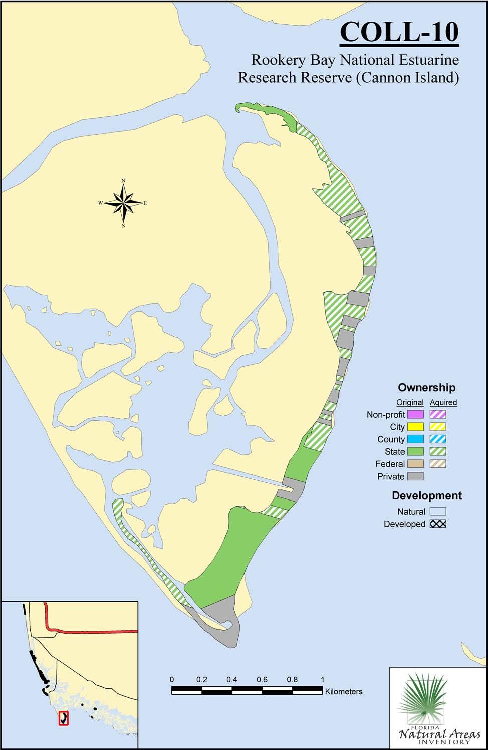
103 COLL-7 Rookery Bay National Estuarine Research Reserve (Cannon Island) Original DOT Aerial: PD (4/2/89) 2004 DOQQ: q1614nw; q1615ne; q1714sw; q1715se Total 1992 natural acres (corrected in 2005): Total 2005 natural acres: Total developed since original report: 0 Total in public ownership* 1992: (including non-profit) Total in public ownership* 2005: (including non-profit) Total natural remaining in private ownership*: 24.2 Public owner: State of Florida; The Conservancy of Southwest Florida (non-profit) Managed by: FL-DEP (CAMA) Managed Area name(s): Rookery Bay National Estuarine Research Reserve Site not re-surveyed. [Evaluation based on interpretation of 2004 true color DOQQ aerial photography at 1m resolution.] 1992 Plant Communities: beach dune (B) coastal grassland (B) coastal interdunal swale (B) maritime hammock (A) 2005 Plant Communities (no change) beach dune (B) coastal grassland (C): now mostly occupied by dense Australian pine (Casuarina equisetifolia). coastal interdunal swale (C): now mostly occupied by dense Australian pine (Casuarina equisetifolia). maritime hammock: (A) Comments: Australian pine seedlings that were noted as invading the coastal grassland in 1991 have grown up into a dense forest. Rare species: no change in FNAI database Site rank: A

104
105 COLL-8 Sand Dollar Island and Tiger Tail Beach Original DOT Aerial: (4/2/89) PD DOQQ: q1614nw; q1615ne Total 1992 natural acres (corrected in 2005): 81.5 Total 2005 natural acres: 81.5 Total developed since original report: 0 Total in public ownership* 1992: 81.5 Total in public ownership* 2005: 81.5 Total natural remaining in private ownership*: 0 Public owner: State of Florida; Collier County Managed by: Collier County? Managed Area name(s): NA Site not re-surveyed. [Evaluation based on interpretation of 2004 true color DOQQ aerial photography at 1m resolution.] 1992 Plant Communities: beach dune (A) coastal interdunal swale (A) coastal grassland (B) 2005 Plant Communities (no change) Comments: offshore sand island is now attached to mainland at east end and inner portions have more continuous vegetative cover; so far the island appears to be relatively free of Australian pine (Casuarina equisetifolia). Rare species: Charadrius melodus, Haematopus palliatus, Pandion haliaetus, Sterna caspia, Sterna maxima, Sterna sandvicensis added to FNAI database. Site rank: A

106
107 COLL-9 Hideaway Beach Original DOT Aerial: (4/2/89) PD DOQQ: q1614nw Total 1992 natural acres (corrected in 2005): 41.1 Total 2005 natural acres: 22.4 Total developed since original report: 18.7 Total in public ownership* 1992: 2.9 Total in public ownership* 2005: 2.9 Total natural remaining in private ownership*: 19.5 Public owner: NA Managed by: NA Managed Area name(s): NA Site not re-surveyed. [Evaluation based on interpretation of 2004 true color DOQQ aerial photography at 1m resolution.] 1992 Plant Communities: beach dune (C) maritime hammock (C) 2005 Plant Communities (no change) beach dune (C) maritime hammock: (C): about half of original area developed. Comments: Rare species: no change in FNAI database Site rank: C

108
109 COLL-10 Rookery Bay National Estuarine Research Reserve (Cape Romano) Original DOT Aerial: (4/2/89) PD DOQQ: q1514ne Total 1992 natural acres (corrected in 2005): Total 2005 natural acres: Total developed since original report: 0 Total in public ownership* 1992: 58.9 Total in public ownership* 2005: Total natural remaining in private ownership*: 35.3 Public owner: State of Florida Managed by: FL-DEP (CAMA) Managed Area name(s): Rookery Bay National Estuarine Research Reserve Site not re-surveyed. [Evaluation based on interpretation of 2004 true color DOQQ aerial photography at 1m resolution.] 1992 Plant Communities: beach dune (B) coastal grassland (B) coastal strand (B) maritime hammock (B) 2005 Plant Communities (no change) Comments: Rare species: Haematopus palliatus, Rynchops niger, Sterna dougallii, Sterna maxima added to FNAI database. Site rank: B
110
111 COLL-11 Ten Thousand Islands National Wildlife Refuge (Shell Key) Original DOT Aerial: NA 2004 DOQQ: q1613sw Total 1992 natural acres (corrected in 2005): 10.6 Total 2005 natural acres: 10.6 Total developed since original report: 0 Total in public ownership* 1992: 10.6 Total in public ownership* 2005: 10.6 Total natural remaining in private ownership*: 0 Public owner: USFWS Managed by: USFWS Managed Area name(s): Ten Thousand Islands National Wildlife Refuge Site not re-surveyed. [Evaluation based on interpretation of 2004 true color DOQQ aerial photography at 1m resolution.] 1992 Plant Communities: shell mound (C) 2005 Plant Communities (no change) Comments: Rare species: no change in FNAI database Site rank: C

112
113 COLL-12 Ten Thousand Islands National Wildlife Refuge (Dismal Key) Original DOT Aerial: NA 2004 DOQQ: q1613se Total 1992 natural acres (corrected in 2005): 53.7 Total 2005 natural acres: 53.7 Total developed since original report: 0 Total in public ownership* 1992: 53.7 Total in public ownership* 2005: 53.7 Total natural remaining in private ownership*: 0 Public owner: USFWS Managed by: USFWS Managed Area name(s): Ten Thousand Islands National Wildlife Refuge Site not re-surveyed. [Evaluation based on interpretation of 2004 true color DOQQ aerial photography at 1m resolution.] 1992 Plant Communities: maritime hammock (A) coastal rock barren (C) 2005 Plant Communities (no change) Comments: Rare species: Crotalus adamanteus added to FNAI database. Site rank: A

114
115 COLL-13 Ten Thousand Islands National Wildlife Refuge (Whitehorse Key) Original DOT Aerial: NA 2004 DOQQ: q1513nw Total 1992 natural acres (corrected in 2005): 6.1 Total 2005 natural acres: 6.1 Total developed since original report: 0 Total in public ownership* 1992: 6.1 Total in public ownership* 2005: 6.1 Total natural remaining in private ownership*: 0 Public owner: State of Florida Managed by: USFWS Managed Area name(s): Ten Thousand Islands National Wildlife Refuge Site not re-surveyed. [Evaluation based on interpretation of 2004 true color DOQQ aerial photography at 1m resolution.] 1992 Plant Communities: beach dune (B) coastal strand (A) 2005 Plant Communities (no change) Comments: Rare species: no change in FNAI database Site rank: B

116
117 MONR-59 Everglades National Park (Northwest Cape Sable) Original DOT Aerial: NA 2004 DOQQ: q1010ne Total 1992 natural acres (corrected in 2005): Total 2005 natural acres: Total developed since original report: 0 Total in public ownership* 1992: Total in public ownership* 2005: Total natural remaining in private ownership*: 0 Public owner: US National Park Service Managed by: US National Park Service Managed Area name(s): Everglades National Park Site not re-surveyed. [Evaluation based on interpretation of 2004 true color DOQQ aerial photography at 1m resolution.] 1992 Plant Communities: beach dune (B) coastal grassland (A) maritime hammock (B) 2005 Plant Communities (no change) Comments: Rare species: no change in FNAI database Site rank: B

118
119 MONR-60 Everglades National Park (Middle Cape Sable) Original DOT Aerial: NA 2004 DOQQ: q1009sw; q010se Total 1992 natural acres (corrected in 2005): Total 2005 natural acres: Total developed since original report: 0 Total in public ownership* 1992: Total in public ownership* 2005: Total natural remaining in private ownership*: 0 Public owner: US National Park Service Managed by: US National Park Service Managed Area name(s): Everglades National Park Site not re-surveyed. [Evaluation based on interpretation of 2004 true color DOQQ aerial photography at 1m resolution.] 1992 Plant Communities: beach dune (A) coastal grassland (A) maritime hammock (B) 2005 Plant Communities (no change) Comments: Rare species: no change in FNAI database Site rank: A

120
121 MONR-61 Everglades National Park (East Cape Sable) Original DOT Aerial: NA 2004 DOQQ: q0909nw; q1009sw Total 1992 natural acres (corrected in 2005): 97.5 Total 2005 natural acres: 97.5 Total developed since original report: 0 Total in public ownership* 1992: 97.5 Total in public ownership* 2005: 97.5 Total natural remaining in private ownership*: 0 Public owner: US National Park Service Managed by: US National Park Service Managed Area name(s): Everglades National Park Site not re-surveyed. [Evaluation based on interpretation of 2004 true color DOQQ aerial photography at 1m resolution.] 1992 Plant Communities: beach dune (A) coastal grassland (A) maritime hammock (B) 2005 Plant Communities (no change) Comments: Rare species: no change in FNAI database Site rank: A

122
123 DADE-9 Everglades National Park (North Florida Bay Hammocks) Original DOT Aerial: NA 2004 DOQQ: q1005ne, nw, sw; q1006ne, se Total 1992 natural acres (corrected in 2005): Total 2005 natural acres: Total developed since original report: 0 Total in public ownership* 1992: Total in public ownership* 2005: Total natural remaining in private ownership*: 0 Public owner: US National Park Service Managed by: US National Park Service Managed Area name(s): Everglades National Park Site not re-surveyed. [Evaluation based on interpretation of 2004 true color DOQQ aerial photography at 1m resolution.] 1992 Plant Communities: maritime hammock (A) 2005 Plant Communities (no change) Comments: Rare species: Jacquinia keyensis added to FNAI database. Site rank: A

124
Preliminary Environmental Site Assessment Report
 Science Working For You Preliminary Environmental Site Assessment Report Wetland and Wildlife Survey Volusia County Parcel 06-19-32-00-00-0030 Prepared for: Orange Blossom Trail Orlando LLC 8650-12 Old
Northern Remnant of the. Everglades Ecosystem. Sylvia R. Pelizza
 Arthur R. Marshall Loxahatchee Nation nal Wildlife Refuge Northern Remnant of the Everglades Ecosystem Sylvia R. Pelizza Project tleader National Wildli fe Refuge System Administered i d by the U.S. Fish
FWC Proposed CWA s in Southwest Florida Could Impact Boa;ng
 FWC Proposed CWA s in Southwest Florida Could Impact Boa;ng CWAs (Cri)cal Wildlife Area s) are established by FWC to protect important concentra)ons of wildlife and manage human ac)vi)es to minimize and
Wulfert Bayous Land Acquisition Campaign. Preserve. Protect. Inspire. Ding Darling Wildlife Society
 Wulfert Bayous Land Acquisition Campaign Preserve. Protect. Inspire. Ding Darling Wildlife Society Project Overview Wulfert Bayous is the largest unprotected property on Sanibel Island, and is adjacent
Kayaks and Compasses, An Extraordinary Fieldtrip into the Thousand Islands
 Kayaks and Compasses, An Extraordinary Fieldtrip into the Thousand Islands Materials created for Kayaks and Compasses by Tim and Laura Kozusko. Revised 2008. All photographs by Tim Kozusko, unless otherwise
Picayune Strand Restoration Project in Southwest Florida A Landscape Perspective
 U.S. Fish and Wildlife Service Restoring America s Everglades-Recovering Multiple Species Picayune Strand Restoration Project in Southwest Florida A Landscape Perspective Kim Dryden U.S. Fish and Wildlife
M E M O R A N D U M. Dianne Rosensweig, Scheda Ecological Associates, Inc. Environmental Assessment and Jurisdictional Determination
 M E M O R A N D U M TO: FROM: RE: Stephen Suau, P.E. Dianne Rosensweig, Scheda Ecological Associates, Inc. Environmental Assessment and Jurisdictional Determination Palmer Ranch Proposed Infill Project
Backcountry Management. Anne Morkill Wildlife Refuge Manager U.S. Fish & Wildlife Service
 Backcountry Management Anne Morkill Wildlife Refuge Manager U.S. Fish & Wildlife Service Florida Keys National Marine Sanctuary Advisory Council Duck Key, FL February 21, 2012 Overview of National Wildlife
Bill Baggs Cape Florida State Park. APPROVED Unit Management Plan
 Bill Baggs Cape Florida State Park APPROVED Unit Management Plan STATE OF FLORIDA DEPARTMENT OF ENVIRONMENTAL PROTECTION Division of Recreation and Parks October 11, 2012 TABLE OF CONTENTS INTRODUCTION...1
Money Bayou Outfall Relocation Project
 Permit Sketches and General Notes Money Bayou Outfall Relocation Project 76 & 768 State Road (SR) Port St. Joe, Florida 2456 Section 9, Township 9S, Range W Gulf County, Florida 29 4.8' N, 85 7.2' W APPLICANT
Environmental Protection
 Myakka Wild and Scenic River Program 2017 Annual Report 1 A. Permitting & Regulatory issues 1. Construction continues at the bridge replacement at C.R. 780. MRP030314 was issued to Sarasota County on March
Spring 2018 PERSEVERANCE. Birds and Stewards Weather Record Storms Coastal Bird Conservation Results. Least Tern Chick Photo: Jim Verhagen
 Spring 2018 PERSEVERANCE Birds and Stewards Weather Record Storms 2017 Coastal Bird Conservation Results Least Tern Chick Photo: Jim Verhagen Audubon Florida s Dynamic Coastal Team Reports Good Year for
1. Qualitative Assessment... II-101
 Table of Contents I. Introduction... I-1 A. Session Law 2009-479 / House Bill 709... I-2 B. Public Consultation... I-3 C. Selection of Study Sites... I-5 D. Limitations of Study... I-8 II. Physical Assessment...
BV-24A DMMA Florida Scrub-Jay Survey Brevard County
 REPORT BV-24A DMMA Florida Scrub-Jay Survey Brevard County Submitted to: David L. Stites, Ph.D. Director of Environmental Services Taylor Engineering, Inc. 10199 Southside Blvd Suite 310 Jacksonville,
Deer Island. a Sportsman s Paradise 90 +/- Acres 0.8 +/- Mile of Gulf of Mexico White Sand Beach 0.8 +/- Mile of Waterfront Facing the Mainland
 Deer Island a Sportsman s Paradise 90 +/- Acres 0.8 +/- Mile of Gulf of Mexico White Sand Beach 0.8 +/- Mile of Waterfront Facing the Mainland 2 Photos of Subject Property Deer Island A Sportsman s Paradise
Florida Beach-nesting Bird Report Summary of FWC s Beach-nesting Bird Database from
 Florida Beach-nesting Bird Report Summary of FWC s Beach-nesting Bird Database from 2005-2008 Prepared by Chris Burney FWC Shorebird Partnership Coordinator chris.burney@myfwc.com FLORIDA BNB REPORT 2005-2008
Rookery Island Clean Ups Remove 8,000 Pounds of Trash and Debris by Kathryn Tunnell
 Stay connected with The Edge: News and Updates from the Coastal Bend Bays & Estuaries Program News and Updates from the Coastal Bend Bays & Estuaries Program Visit Our Website Rookery Island Clean Ups
Birding Information for Photographers DPI- SIG 5/9/2013
 Birding Information for Photographers DPI- SIG 5/9/2013 Title: Finding the Birds by Arthur Sissman & Ron Perkins 20 minutes I. Factors to Consider Tides (Charts) Water - Fresh, Salt, Brackish Habitat Time
Lisa B. Beever Greater Everglades Ecosystem Restoration Conference July 15, 2010
 Lisa B. Beever Greater Everglades Ecosystem Restoration Conference July 15, 2010 Climate Ready Estuaries Partnership with 15 NEPs and EPA Barnegat Bay NEP www.epa.gov/cre Comprehensive Conservation and
Conservation Lands Program Update July 2017
 Conservation Lands Program Update July 2017 Beth Powell Conservation Lands Manager Wendy Swindell Conservation Lands Technician IRC Environmental Lands CONSERVATION PROGRAM OVERVIEW In 1990, the County
Beach Management Funding Assistance Program
 DEPARTMENT OF ENVIRONMENTAL PROTECTION Division of Water Resource Management January 23, 2014 Fixed Capital Outlay Local Government Funding Requests For FY 2014/2015 TABLE OF CONTENTS Introduction... 4
CHOCTAWHATCHEE AUDUBON SOCIETY P. O. Box 1044, Niceville, Florida ChoctawhatcheeAudubon.org
 CHOCTAWHATCHEE AUDUBON SOCIETY P. O. Box 1044, Niceville, Florida 32588 ChoctawhatcheeAudubon.org Hi fellow Audubon members, wildlife photographers, nature lovers, and friends, September 1, 2016 Veterans
Dredging, Beach Nourishment and. Bird Conservation Workshop Atlantic Coast Region
 Dredging, Beach Nourishment and US Army Corps Bird Conservation Workshop Atlantic Coast Region Beach Nourishment and Bird Habitat Restoration in Southern New Jersey Shore Protection and Ecosystem Restoration
Least Bell's Vireo & Western Burrowing Owl Surveys
 I - 15 CORRIDOR CAMPUS MASTER PLAN DRAFT EIR MT. SAN JACINTO COMMUNITY COLLEGE DISTRICT Appendices Appendix D5 Least Bell's Vireo & Western Burrowing Owl Surveys August 2017 I - 15 CORRIDOR CAMPUS MASTER
Northeast Florida Coastal Wetland Restoration Program A Partnership Based Regional Approach for Estuary Habitat Restoration
 Northeast Florida Coastal Wetland Restoration Program A Partnership Based Regional Approach for Estuary Habitat Restoration Paul Haydt Restore America s Estuaries November 15, 2010 St Johns River Water
Collaboration and Planning to Implement the South San Diego Bay Restoration and Enhancement Project
 Collaboration and Planning to Implement the South San Diego Bay Restoration and Enhancement Project Carolyn Lieberman Coastal Program Coordinator for Southern California U.S. Fish and Wildlife Service
Jackson Bottom Wetlands Preserve BCS Number: 47-14
 Jackson Bottom Wetlands Preserve BCS Number: 47-14 Site description author(s) Greg Gillson, Jackson Bottom Wetlands Preserve Primary contact for this site Ed Becker, Natural Resources Manager, Jackson
Stay Out Zones and Boom Priorities for Shorebirds in Franklin County
 Stay Out Zones and Boom Priorities for Shorebirds in Franklin County C All the Coastal Beaches that are Publically Owned (State and Federal) have use by nesting birds. These areas are posted. BMPs for
June 2018 Wrack Line Newsletter
 We only use cookies that are necessary for this site to function, and to provide you with the best experience. Learn more in our Cookie Statement. By continuing to use this site, you consent to the use
National Audubon Society. Coastal Bird Conservation Program
 National Audubon Society Coastal Bird Conservation Program Coastal Bird Conservation Program This presentation contains original photos and data. For any use of this information, data, maps, or photographs
Beaver Island Archipelago: Invasive Species Control Final Report Submitted by:
 Beaver Island Archipelago: Invasive Species Control Final Report Submitted by: 4371 N Long Lake Rd Traverse City, MI 49684 wildlife@wildlifewetlands.com (231) 943-0762 Project Plan and Schedule 2014 Treatment
COASTAL MANAGEMENT ELEMENT
 COASTAL MANAGEMENT ELEMENT of the PINELLAS COUNTY COMPREHENSIVE PLAN Prepared By: The Pinellas County Planning Department as staff to the LOCAL PLANNING AGENCY for THE BOARD OF COUNTY COMMISSIONERS OF
Golden Eagle (Aquila chrysaetos) Management Indicator Species Assessment Ochoco National Forest
 Management Indicator Species Assessment Ochoco National Forest") Golden Eagle (Aquila chrysaetos) Management Indicator Species Assessment Ochoco National Forest I. Introduction The golden eagle was chosen as a terrestrial management indicator species (MIS) on the Ochoco
Golden Eagle (Aquila chrysaetos) Management Indicator Species Assessment Ochoco National Forest I. Introduction The golden eagle was chosen as a terrestrial management indicator species (MIS) on the Ochoco
Lee County has a type 4, E System consisting of 4 Primary and 1 Secondary PSAPs.
 9.35 LEE COUNTY 9.35.1 SYSTEM SUMMARY Lee County has a type 4, E 9-1-1 System consisting of 4 Primary and 1 Secondary PSAPs. 9.35.1.1 CAPE CORAL POLICE DEPARTMENT PRIMARY PSAP The City of Cape Coral has
To: EverPower From: Stantec Consulting Services Inc. NYSDEC. 30 Park Drive Topsham, ME File: Date: February 11, 2014
 Memo To: From: Stantec Consulting Services Inc. NYSDEC 30 Park Drive Topsham, ME File: 195600883 Date: February 11, 2014 Reference: Cassadaga Wind Project Habitat Assessment INTRODUCTION Following the
Snowy Plover Adaptive Management
 2015 Snowy Plover Adaptive Management Strategies for snowy plover conservation on public lands along Lido and Siesta Keys j n 1. Sarasota County Snowy Plover Adaptive Management Prepared for: Sarasota
Florida's Environment - Southwest Region 1
 WEC236 Florida's Environment - Southwest Region 1 Martin B. Main and Ginger M. Allen 2 Florida's Environment Series Introduction Southwest Florida (Fig.1) is dominated by wetland ecosystems, 40 percent
South Western Florida Photography Workshop
 South Western Florida Photography Workshop Little Estero, Sanibel, Venice, Marco Island March 4-10, 2012 Florida is famous for bird photography, and the South West has some of the best bird photography
FIRST RECORDS OF BROWN PELICAN (Pelecanus occidentalis) NESTING IN POLK COUNTY, FLORIDA
 NESTING IN POLK COUNTY, FLORIDA") Florida Field Naturalist 43(2):62-68, 2015. FIRST RECORDS OF BROWN PELICAN (Pelecanus occidentalis) NESTING IN POLK COUNTY, FLORIDA Ann F. Paul 1 and Ann B. Hodgson 2 1 Audubon Florida, Florida Coastal
Florida Field Naturalist 43(2):62-68, 2015. FIRST RECORDS OF BROWN PELICAN (Pelecanus occidentalis) NESTING IN POLK COUNTY, FLORIDA Ann F. Paul 1 and Ann B. Hodgson 2 1 Audubon Florida, Florida Coastal
PRELIMINARY ECOLOGICAL ASSESSMENT REPORT Lake Hamilton Parcels: Polk County, Florida
 PRELIMINARY ECOLOGICAL ASSESSMENT REPORT Lake Hamilton Parcels: 272817829501000010 272817829503000040 272817829503000030 Polk County, Florida PREPARED BY: INWOOD CONSULTING ENGINEERS, INC. 3000 Dovera
Tracy Monegan Rice Terwilliger Consulting, Inc. October 2012
 . The Status of Sandy Oceanfront Beach Habitat in the Continental U.S. Coastal Migration and Wintering Range of the Piping Plover (Charadrius melodus) 1 Tracy Monegan Rice Terwilliger Consulting, Inc.
CISMA Call Agenda. FISP Update (Kris/Erin) CISMA/CWMA. News Wrap-up
 CISMA/CWMA. News Wrap-up") CISMA Call Agenda FISP Update (Kris/Erin) CISMA/CWMA Updates (All) News Wrap-up Florida Invasive Species Partnership Invasive species know no boundaries. If landowners and land managers in Florida wish
CISMA Call Agenda FISP Update (Kris/Erin) CISMA/CWMA Updates (All) News Wrap-up Florida Invasive Species Partnership Invasive species know no boundaries. If landowners and land managers in Florida wish
Matagorda Island Marsh Restoration An Adaptive Management Approach by Coastal Bend Bays & Estuaries Program
 Matagorda Island Marsh Restoration An Adaptive Management Approach by Coastal Bend Bays & Estuaries Program 1957: After Levees 1930: Before Levees Matagorda Island: Site Location Texas Coastal Bend Calhoun
SEBASTIAN AREA-WIDE SCRUB-JAY HABITAT CONSERVATION PLAN & Public Use Improvements
 SEBASTIAN AREA-WIDE SCRUB-JAY HABITAT CONSERVATION PLAN & Public Use Improvements Beth Powell Conservation Lands Manager Parks Division Indian River County Description of the HCP Allows for Incidental
2017 Income Limits and Rent Limits Florida Housing Finance Corporation SHIP Program
 Alachua County 30% 13,650 16,240 20,420 24,600 28,780 32,960 37,140 41,320 Refer to HUD 341 373 510 667 824 980 (Gainesville MSA) 50% 22,750 26,000 29,250 32,450 35,050 37,650 40,250 42,850 45,430 48,026
The Impact of Development and Projected Sea-Level Rise on Florida s Ecoregional Portfolio
 The Impact of Development and Projected Sea-Level Rise on Florida s Ecoregional Portfolio The Florida Portfolio is the combined product of individual ecoregional assessments conducted for the Tropical
St. Andrews State Park
 St. Andrews State Park APPROVED Unit Management Plan STATE OF FLORIDA DEPARTMENT OF ENVIRONMENTAL PROTECTION Division of Recreation and Parks April 2016 TABLE OF CONTENTS INTRODUCTION... 1 PURPOSE AND
PUBLIC NOTICE. Permit Application No. SAJ (IP-MJD)
") DEPARTMENT OF THE ARMY JACKSONVILLE DISTRICT CORPS OF ENGINEERS FORT MYERS REGULATORY OFFICE 1520 ROYAL PALM SQUARE BOULEVARD, SUITE 310 FORT MYERS, FLORIDA 33919 Regulatory Division South Permits Branch/West
DEPARTMENT OF THE ARMY JACKSONVILLE DISTRICT CORPS OF ENGINEERS FORT MYERS REGULATORY OFFICE 1520 ROYAL PALM SQUARE BOULEVARD, SUITE 310 FORT MYERS, FLORIDA 33919 Regulatory Division South Permits Branch/West
Environmental Assessment Report. Siena Lakes PUD (aka: LCS Naples CCRC PUD)
") Environmental Assessment Report of Siena Lakes PUD (aka: LCS Naples CCRC PUD) 29.25 acre Parcel Sec. 01, T49S, R25E Orange Blossom Drive, Collier County, FL September 29, 2008 Revised: April 2, 2009 Updated:
Environmental Assessment Report of Siena Lakes PUD (aka: LCS Naples CCRC PUD) 29.25 acre Parcel Sec. 01, T49S, R25E Orange Blossom Drive, Collier County, FL September 29, 2008 Revised: April 2, 2009 Updated:
Siletz Bay BCS number: 47-29
 Siletz Bay BCS number: 47-29 ***NOTE: We were unable to determine all necessary information for this site description. If you would like to contribute the needed information to this description, please
Black-crowned Night-heron Minnesota Conservation Summary
 Credit Deborah Reynolds Black-crowned Night-heron Minnesota Conservation Summary Audubon Minnesota Spring 2014 The Blueprint for Minnesota Bird Conservation is a project of Audubon Minnesota written by
MINNESOTA NAWCA PROJECTS
 NAWCA S $40,343,809 $152,258,606 125 270,804 NAWCA GRANT AMOUNT TOTAL PARTNER CONTRIBUTION NUMBER OF S TOTAL ACRES Minnesota currently has 125 NAWCA projects either completed or underway. These projects
TABLE OF CONTENTS. Executive Summary 1 Acknowledgements 3 Introduction 3 Storm Recovery and Beach Project Effectiveness 3
 TABLE OF CONTENTS Executive Summary 1 Acknowledgements 3 Introduction 3 Storm Recovery and Beach Project Effectiveness 3 Monmouth County 4 Figures 1a-1d. Monmouth County Station Locations 5 Site Descriptions
Beach nesting Bird Breeding Census and Report for Coastal Alabama 2007
 National Audubon Society Coastal Bird Conservation Program Beach nesting Bird Breeding Census and Report for Coastal Alabama 27 Margo Zdravkovic National Audubon Society Coastal Bird Conservation Program
In this issue. Events & reminders. Events & reminders. 2. FSA news FSD updates.. 7. Ebb tidings... 9
 APRIL 2014 1 In this issue Events & reminders. 2 FSA news... 3 Highlights from the 2014 Winter Shorebird Survey Expanded shorebird monitoring in the panhandle FSD updates.. 7 2014 Breeding Season begins!
Gulf of Mexico. Lido Key, Sarasota County Florida Hurricane and Storm Damage Reduction Project Aerial Map. Notes: Legend: #0 FDEP Monuments R-35 R-34
 466500 1086000 467000 1085500 R-35 1085000 467500 1084500 BENJAMIN FRANKLIN DR T-36 1084000 R-34 North Lido Public Beach G:\Enterprise\Sarasota\150252_Lido_Key_Storm_Damage_Reduction_Project_Permitting\MXD\Lido_Key_Aerial_a.mxd
Party With a Purpose: MARSTEL-DAY GREEN GALA
 Party With a Purpose: MARSTEL-DAY GREEN GALA Tree Fredericksburg Eastern Shore Virginia I Featherstone I Fisherman Island I James River I Mason Neck Nansemond I Occoquan Bay I Plum Tree Island I Presquile
EagleWatch By The Numbers ( ) 511 nest monitored statewide volunteers & partners. 7,200 reports of nest activity
 511 nest monitored statewide volunteers & partners. 7,200 reports of nest activity") 2016-2017 EagleWatch By The Numbers (2016-2017) Audubon EagleWatch experienced significant growth in monitoring efforts for the 2016-2017 nesting season. Photo: Kathy Abbott 230+ volunteers & partners
2016-2017 EagleWatch By The Numbers (2016-2017) Audubon EagleWatch experienced significant growth in monitoring efforts for the 2016-2017 nesting season. Photo: Kathy Abbott 230+ volunteers & partners
IRIS External Interfaces
 IRIS External Interfaces FRS Participating Agencies: https://www.rol.frs.state.fl.us/forms/part-emp.pdf SAMAS (State Automated Management Accounting System)/State Comptroller, Florida Department of Financial
Eastern Lake Ontario Dunes D-3 Assessment SLELO-PRISM Buckthorn and Swallow-wort Surveillance/Dune Willow Monitoring
 St. Lawrence Eastern Lake Ontario Partnership for Regional Invasive Species Management Eastern Lake Ontario Dunes D-3 Assessment Buckthorn and Swallow-wort Surveillance/Dune Willow Monitoring July 13 &
Habitat Needs of Bats in Sandhills
 Habitat Needs of Bats in Sandhills Holly Ober Dept of Wildlife Ecology & Conservation University of Florida How many kinds of bats live in FL? a) 1,100 b) 48 c) 13 1 How many kinds of bats live in Florida?
PART FIVE: Grassland and Field Habitat Management
 PART FIVE: Grassland and Field Habitat Management PAGE 64 15. GRASSLAND HABITAT MANAGEMENT Some of Vermont s most imperiled birds rely on the fields that many Vermonters manage as part of homes and farms.
Establishment of Additional Monarch Butterfly Host Plants at the Sand Hill Lakes Mitigation Bank
 Establishment of Additional Monarch Butterfly Host Plants at the Sand Hill Lakes Mitigation Bank David Clayton Environmental Scientist III David.Clayton@nwfwater.com Northwest Florida Water Management
CALL TO ARTISTS. Southwest Florida Annual Juried Painting Exhibition"
 CALL TO ARTISTS Southwest Florida Annual Juried Painting Exhibition" Friends of Rookery Bay (FORB) and the United Arts Council of Collier County (UAC) are seeking submissions for their annual painting
Ray Allen Executive Director (361)
") Ray Allen Executive Director (361)885-6204 rallen@cbbep.org www.cbbep.org CBBEP History 1987 U.S. Congress established the National Estuary Program (NEP) to promote longterm planning and management of
Ray Allen Executive Director (361)885-6204 rallen@cbbep.org www.cbbep.org CBBEP History 1987 U.S. Congress established the National Estuary Program (NEP) to promote longterm planning and management of
Florida Keys National Wildlife Refuge Complex. Key West NWR Great White Heron NWR National Key Deer NWR Crocodile Lake NWR
 Florida Keys National Wildlife Refuge Complex Key West NWR Great White Heron NWR National Key Deer NWR Crocodile Lake NWR Key West NWR Marquesas Keys and 13 other keys Mission as a preserve and protect
FIELD SURVEYS FOR MOUNTAIN PLOVERS (Charadrius montanus) IN THE CASPER FIELD OFFICE REGION
 IN THE CASPER FIELD OFFICE REGION") FIELD SURVEYS FOR MOUNTAIN PLOVERS (Charadrius montanus) IN THE CASPER FIELD OFFICE REGION Report prepared by: Dr. Gary P. Beauvais, Director Wyoming Natural Diversity Database University of Wyoming Laramie,
FIELD SURVEYS FOR MOUNTAIN PLOVERS (Charadrius montanus) IN THE CASPER FIELD OFFICE REGION Report prepared by: Dr. Gary P. Beauvais, Director Wyoming Natural Diversity Database University of Wyoming Laramie,
Florida Field Naturalist
 Florida Field Naturalist PUBLISHED BY THE FLORIDA ORNITHOLOGICAL SOCIETY VOL. 29, NO. 3 SEPTEMBER 2001 PAGES 75-112 Florida Field Naturalist 29(3):75-80, 2001. AMERICAN OYSTERCATCHERS NEST ON GRAVEL-COVERED
Report to the Monarch Joint Venture Monitoring of Monarch Overwintering Sites in California 2013
 Report to the Monarch Joint Venture Monitoring of Monarch Overwintering Sites in California 2013 Overwintering monarch on eucalyptus, Santa Barbara County, CA. Photo by Candace Fallon / The Xerces Society
MOTE NUUUNE LABORATORY MANATEE RESEARCH ACTIVITIES.
 MOTE NUUUNE LABORATORY MANATEE RESEARCH ACTIVITIES. First Progress Report: August 25, 2008 M MARINE LABORATORY Includes three reports: Photo-Identification Studies on Manatees in Southwestern Florida By:
Baskett Slough National Wildlife Refuge BCS number: 47-4
 Baskett Slough National Wildlife Refuge BCS number: 47-4 Site description author(s) Daphne E. Swope, Research and Monitoring Team, Klamath Bird Observatory Primary contact for this site N/A Location (UTM)
ANNUAL REPORT. Avian Research Subsection Wildlife Research Section Fish and Wildlife Research Institute
 ANNUAL REPORT Avian Research Subsection Wildlife Research Section Fish and Wildlife Research Institute Project Number: 9257 251 1000 Project Title: Project Investigator: Project Manager: American Oystercatcher
Audubon Newsletter May 2017 Christine Hepburn
 Audubon Newsletter May 2017 Christine Hepburn In case you were wondering about the gorgeous purple blooms on a tree across from the driving range (and also in Frank Park), Nina Podrasky identified the
Cat Island Chain Restoration Project Brown County Port & Resource Recovery Department
 Cat Island Chain Restoration Project Brown County Port & Resource Recovery Department February 2, 2015 Fox River and Lower Green Bay Cat Island Chain - 1938 Cat Island Brown County Aerial Photography,
Florida's Environment - Central East Region 1
 WEC235 Florida's Environment - Central East Region 1 Martin B. Main and Ginger M. Allen 2 Florida's Environment Series Introduction The central east region extends from County in the north to St. Lucie
Supplementary Material I.
 Supplementary Material I. Data sources The dataset analyzed in the present study, was developed by deriving information from published papers, Symposium Proceedings, Annual Monitoring Reports, Inter-annual
Removed. Scientific Skills. Gel Chromatography Thin Layer Chromatography NMR Reading Spectrophotometer Reading Centrifuge Handling
 Removed date Removed EDUCATION BA Florida Gulf Coast University, Ft. Myers (anticipated graduation = 2010) Major = Biology; Minor = Chemistry; Philosophy; & Interdisciplinary Studies High School Cape Coral
Appendix A. Planning to Stay Element A-1
 Appendix A Planning to Stay Element A-1 Planning to Stay Element A-2 Short History of Urban Development in Pinellas County, Florida i Pinellas is a small peninsula roughly 34.5 miles in length and 5.2
Forest Bird Habitat Assessment Fairlee Town Forest
 Forest Bird Habitat Assessment Fairlee Town Forest Fairlee, VT Prepared by: Steve Hagenbuch 1/3/2014 View north from Bald Top 2 Forest Bird Habitat Assessment Prepared for the Town of Fairlee, VT - Fairlee
Oregon Dunes National Recreation Area BCS Number: 47-5
 Oregon Dunes National Recreation Area BCS Number: 47-5 ***NOTE: We were unable to determine all necessary information for this site description. If you would like to contribute the needed information to
Oil Spill Funds and the Opportunities they Present for Galveston Bay
 Oil Spill Funds and the Opportunities they Present for Galveston Bay A presentation to Texas Environmental Grantmakers Group By Bob Stokes, President, Galveston Bay Foundation Friday, October 31, 2014
CHAPTER. Coastal Birds CONTENTS. Introduction Coastal Birds Action Plan. 108 cbbep.org
 CHAPTER 9 Coastal Birds CONTENTS Introduction Coastal Birds Action Plan 108 cbbep.org Introduction The South Texas coast is one of the most unique areas in North America and is renowned for its exceptional
WISCONSIN BIRD CONSERVATION INITIATIVE IMPORTANT BIRD AREAS PROGRAM
 WISCONSIN BIRD CONSERVATION INITIATIVE IMPORTANT BIRD AREAS PROGRAM NOMINATION FORM The Wisconsin Bird Conservation Initiative (WBCI) is conducting an inventory of areas that may qualify as Important Bird
Division: Habitat and Species Conservation Authors: Claire Sunquist Blunden and Brad Gruver
 Division: Habitat and Species Conservation Authors: Claire Sunquist Blunden and Brad Gruver Report date: December 13, 2018 All photos by FWC unless otherwise acknowledged Presenting 6 new guidelines 1
2017 Shell Key Preserve Management Plan Update DRAFT
 2017 Shell Key Preserve Management Plan Update DRAFT Prepared by Pinellas County Parks and Conservation Resources Revised on October 19, 2017 Shell Key Preserve Management Plan Executive Summary State
HURRICANE IRMA. Assessment Report
 HURRICANE IRMA Assessment Report This assessment provides a detailed early look at the impacts of Hurricane Irma to the critical bird and wildlife habitats of the affected areas in Florida. Early recovery
Site Description: Gull Rock is located approximately 0.4 miles offshore and about six miles north of Yaquina Head in Lincoln County, Oregon.
 Devil s Punchbowl intertidal area Gull Rock (offshore) 12. Gull Rock Site Description: Gull Rock is located approximately 0.4 miles offshore and about six miles north of Yaquina Head in Lincoln County,
Canal Current. Environmental News. Native Plant profile
 Canal Current A wave of information for Cape Coral s Canalwatch volunteers Newsletter: 1 st Quarter 2011 Environmental News The BP Oil Spill, 1 year Later The one year anniversary of the BP Deep Water
Marine Corps Support Facility-Blount Island: Integrated Natural Resources Program Successes. E2S2 Conference May 12, 2011
 Marine Corps Support Facility-Blount Island: Integrated Natural Resources Program Successes E2S2 Conference May 12, 2011 Shari Kennedy, MCSF-BI Robert Price, CH2M HILL Location Mission The mission of Marine
Tracking Florida s Biodiversity
 February 10, 2010 Requester Name Company Name Address City,, Zip Dear Requester, Thank you for your request for information from the Florida Natural Areas Inventory (FNAI). We have compiled the following
North American Wetlands Conservation Act
 North American Wetlands Conservation Act MAINE Maine currently has 90 NAWCA projects either completed or underway. These projects have conserved a total of 1,031,300 acres of wildlife habitat. NAWCA funding
Santa Clara Valley Habitat Plan
 Santa Clara Valley Habitat Plan Joint Governing & Implementation Board Meeting Burrowing Owl Survey Summary and Fee Map January 15, 2015 29 1 Agenda Brief Overview of the Key Aspects of the Burrowing Owl
Buckner Preserve Shrubland Habitat Management Recommendations
 Buckner Preserve Shrubland Habitat Management Recommendations Margaret Fowle & Mark LaBarr Audubon Vermont 255 Sherman Hollow Rd Huntington, VT 05462 October 2015 Background Information The following pages
Peregrine Falcon Falco peregrinus
 Plant Composition and Density Mosaic Distance to Water Prey Populations Cliff Properties Minimum Patch Size Recommended Patch Size Home Range Photo by Christy Klinger Habitat Use Profile Habitats Used
Tualatin River NWR and Wapato Lake BCS number: 47-37
 Tualatin River NWR and Wapato Lake BCS number: 47-37 ***NOTE: We were unable to determine all necessary information for this site description. If you would like to contribute the needed information to
Partnerships in Action
 Partnerships in Action USDA NRCS Partnership History & Management of Golden Winged Warbler Habitat In Vermont. By: Dave Adams Vermont Fish and Wildlife Department Vermont Fish and Wildlife Department To
2/26/ % located in Collier, Lee, Monroe, Dade Ten Thousand Islands region Tampa Bay & Indian River Lagoon Largest mangrove forest in USA
 Mangroves Florida: 190,000 hectares of mangrove 90% located in Collier, Lee, Monroe, Dade Ten Thousand Islands region Tampa Bay & Indian River Lagoon Largest mangrove forest in USA Mangroves: tropical
2006 Beach nesting Bird Census and Report for Coastal Mississippi
 National Audubon Society Coastal Bird Conservation Program 2006 Beach nesting Bird Census and Report for Coastal Mississippi Margo Zdravkovic National Audubon Society Coastal Bird Conservation Program
Chaumont Bay SLELO-PRISM Water Chestnut & Hydrilla Surveillance 2012
 St. Lawrence Eastern Lake Ontario Partnership for Regional Invasive Species Management Chaumont Bay & Hydrilla Surveillance 2012 July 3, 5, 6 & 10 (Water Chestut); August 9 & 13 (Hydrilla), 2012 Figure
Resilient Birds, Devoted Advocates 2016 Coastal Bird Conservation Results. Spring American Oystercatcher Photo by Matt Filosa
 Resilient Birds, Devoted Advocates 2016 Coastal Bird Conservation Results Spring 2017 American Oystercatcher Photo by Matt Filosa Florida s coastal birds face long odds, but Audubon support gives them