Current and Future Meteorological Satellite Program of China
|
|
|
- Betty Bailey
- 5 years ago
- Views:
Transcription
1 Current and Future Meteorological Satellite Program of China ZHANG Wenjian, DONG Chaohua XU Jianmin, YANG Jun China Meteorological Administration May 30, 2005 Beijing, CHINA
2 Outline of the Presentation 1. Current Meteorological Satellites 2. Future Plans and Considerations for China s Met. Sat. Program 3. Conclusion
3 1. Current Chinese Meteorological Satellites 1.1 Polar 1.2 Geostationary

4 FY-1D: The Chinese Polarorbiting Operational Satellite FY-1D was launched on May 15, 2002 Operation is now over design life and still health in operation
5 Characteristics of the 10-Ch. Radiometer of FY-1 Channel Wavelength(µm) Purpose Channel Close to current NOAA/AVHRR Ocean color Ocean color Ocean color Water vapor

6

7 FY-1D HRPT Received At Europe

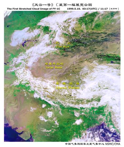
8 Global Multi-Orbit Mosaic Image
")
9 Composite Imagery of Antarctic Region by FY-1D GDPT (Ch. 1,2,3 Composite. )
10 Current Chinese Meteorological Satellites 1.1 Polar 1.2 Geostationary
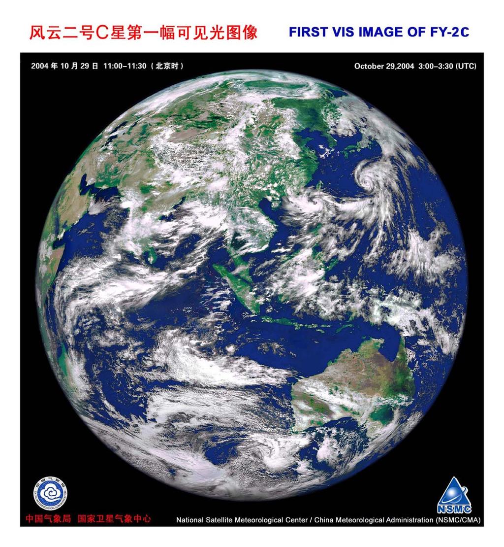
, Oct. 19, 2004; FY-2C Located at 105ºE on Oct.")
11 Successful launch of FY-2C Launch and position FY-2C launched at 09:20 (BJ), Oct. 19, 2004; FY-2C Located at 105ºE on Oct. 24, 2004
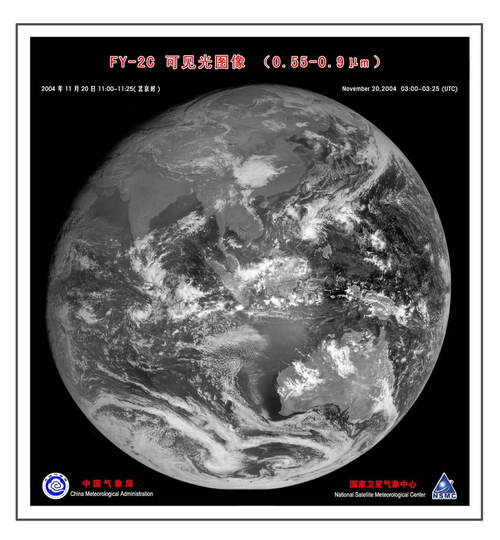
12 FY-2C/D/E/F/G: operational series FY-2 Op series is consists of FY-2C/D/E three satellites and 2 more satellites will be added (FY-2F&FY-2G) for connection to FY-4. The Op series is improved based on FY-2A/B with the major improvements on: Five channel radiometers; More products for widely use in meteorology and Environment (Dr. XU will have more slides to show) More frequent observations during the main flooding season (June August) half-hourly image (48 images each day)
13 FY-2A/B (Exp) FY-2C/D/E/F/G (Op) Channels Wavelength (µm) (quantization) Channels Wavelength (µm) (quantization) (6 bits) (8 bits) (8 bits) (6 bits) (10 bits) (8 bits) (10 bits) (10 bits)
14
15
16
17

18
19

20

21 Ocean Land FY2C IR 3 3.9um Fire spots in Australia

22 Lake Cirrus FY2C VIS River Snow Snow Fog
23 2. Future Plans and Considerations for China s Met. Sat. Program 2.1 Polar Satellites Program 2.2 GEO Satellites Consideration
24 The 2nd gen. of polar satellites Purpose of FY-3A/B (exp.) Risk reduction in Engineering Products development and validation Utilization Demo in some area
25 Two phase of FY-3 series There are two developing phases for FY-3: i.e.. Exp. Phase ( in flight): 2 satellites with limited sounding capabilities FY-3A Launch scheduled in Early 2007 FY-3B launched scheduled in Early 2009 Operational Phase (flight after 2009 ): Satellites Constellation is planned with expanded sounding and imaging capabilities
26 FY-3A Satellite: Progress Phase A (Design and Structure) Sept Nov Phase B (Engineering Model) Dec July 2005 Phase C (Flight Model) Aug Dec (Ready for Launch )
27 Main specifications of FY-3A Orbit: Sun-synchronous polar-orbiting Orbit altitude: 836 km Inclination= degree Eccentricity: better than Nodal crossing time: 10:10-10:20 am (LST, FY-3B could be at afternoon orbit) Orbit drifting: < 10 minutes (within 2 years)
28 Main specifications of FY-3A (cont.) Power: 1100 watts (orbital average, estimated) Weight: 2200 kg (estimated now) Size : 4400*2000*2000 (X,Y,XZ :in stowed) : 4400*10000*2000 (X,Y,Z : in flight) Design life: >= 3 years

29 One-day orbital coverage

30 Satellite in flying mode
31 Main Instruments on FY-3 (1) Sounding Mission(5 instruments) Infrared Atmospheric Sounder (IRAS) MicroWave atmospheric Temperature Sounder (MWTS) MicroWave atmospheric Humidity Sounder (MWHS, AMSU-B like,onboard FY-3A/B ) Multichannel Atmospheric Infrared Sounder (MAIRS, OP. phase) Solar Backscatter Ultraviolet and Total Ozone Sounder (SBUV/TOS)
32 Main Instruments on FY-3 (2) Imaging Mission(3 instruments) Visible and Infrared Radiometer(VIRR, 10 channels, similar to radiometer aboard FY-1C) Medium Resolution Spectral Imager(MERSI) MicroWave Radiation Imager (MWRI)
33 Main Instruments on FY-3 (3) Complementary Mission Earth Radiation Budget Unit (ERBU) Space Environment Monitor (SEM) Data Collection System (DCS)
34 Data types: HRPT format Band frequency: MHz Band Width: 5.4 MHz Modulation: QPSK Data rate: 4.2 Mbps Encoding: CONV(7, ¾) Broadcasting: Real time
35 Data types: DPT format DPT=Delayed Picture Transmission Band frequency: / MHz Band Width: 140 MHz Modulation: QPSK Data rate: 110 Mbps Encoding: CONV(7, ¾) Broadcasting: Within China capture area
36 Data types: MPT format MPT=Mission Picture Transmission Band frequency: MHz Band Width: 25 MHz Modulation: QPSK Data rate: 20 Mbps Encoding: CONV(7, ¾) Broadcasting: program controlled
37 Science Data Downlink Service Allocations instrument HRPT MPT Stored time DPT VIIR 810 min IRAS 810 min MWTS 810 min MERSI 120 min MWRI 810 min TOMS/SBUV 810 min SEM 810 min ERBU 810 min MWHS 810 min
38

39 Larger Firing is needed for FY-3

40 Solar panel testing of FY-3A
41 FY-3 Operational Constellation Considerations Instruments on FY-3A/B will be improved and refined for FY-3 Op satellites Two polar satellites in operation (one in the AM and one in the PM orbit, payload will be different for AM/PM satellites, time slots could be coordinated through WMO) One low inclination orbit satellite is planning, mainly for precipitation measurement (mainly Radar, Passive Microwave measurement). Details is still in discussion
42 FY-3 3 Ground Segment 7 receiving stations, one of the stations will be in high latitude place (Svabald) Products from FY-3 will be broadcasted by DVBS
43 90 W Sval Bar d 90 E

44 Data transmission to Beijing and then re-transmit (DVBS) This technology will be used in FY-3 data re-transmission
45 Future Geostationary Satellites
46 FY-2 D/E/F/G: launch schedule FY-2D will be launched in early 2007 with current plan By then FY-2C would be still health, then two GEO constellation will be formed: Wider coverage (possible FY-2C in 123E, and FY-2D in 87.5E, also for contingency) More frequent observations during the flooding season for overlap areas New products (ex. Stereo cloud, new wind-height assignment, etc. ) FY-2E is plan to launch in early 2009 to replace FY-2C FY-2F/G will replace FY-2D and FY-2E in 2011 and 2013, respectively
47 New Generation for Geo: FY-4 Considerations on FY-4 Three-Axis Stabilization More powerful imager and lightning mapper Sounding capability (Spectrometer?) More powerful Data Collection Platforms Enhanced ground control capability Enhanced application and services systems
48 Constellation including two series: refer to A series and B series A: VIS and IR satellites, early launch around 2012 B: Microwave satellites, early launch around 2015 Now FY-4 is at the Pre-Phase A stage, schedule to be developed during , and launch after 2012
49 Consideration of A type payload Powerful imager with more than 12 channels A hyper-spectral instrument is pursued on as the IR sounder with reasonable spatial resolution ( China is very interested in IGEOLAB for GIFTS) Lightning mapper for locating the thunderstorm in flooding season
50 Consideration of B type payload Microwave sounder working on higher frequencies for sounding the cloudy atmosphere(china is also interested in IGeoLab of Geo Microwave project) CCD camera with high spatial resolution for frequent high resolution imagery observation for the severe weather A Solar telescope and a SEM will be developed fro space weather service
51 FY-4 ground segment To have enhanced control capability Application will cover weather, climate and environment, as well as rapid response fields
52 3. Conclusion To meet national requirements and modernizing the meteorological service of China and world meteorological community. China will continue her effort to develop two types of satellites (LEO and GEO). Chinese satellites, as a integrated part of the space component of WMO GOS, are not only benefit the nation of China, but also reflect the contribution to the international Earth Observation community.
53 The End Thanks!
The Sounding Instruments on Second Generation of Chinese Meteorological Satellite FY-3
 The Sounding Instruments on Second Generation of Chinese Meteorological Satellite FY-3 DONG Chaohua ZHANG Wenjian National Satellite Meteorological Center China Meteorological Administration Beijing 100081,
REPORT ON THE STATUS OF CURRENT AND FUTURE RUSSIAN SATELLITE SYSTEMS
 Prepared by ROSH/ROSC Agenda Item: Session D Discussed in Plenary REPORT ON THE STATUS OF CURRENT AND FUTURE RUSSIAN SATELLITE SYSTEMS This document addresses the current status of the satellite systems:
The Global Imager (GLI)
") The Global Imager (GLI) Launch : Dec.14, 2002 Initial check out : to Apr.14, 2003 (~L+4) First image: Jan.25, 2003 Second image: Feb.6 and 7, 2003 Calibration and validation : to Dec.14, 2003(~L+4) for
The Global Imager (GLI) Launch : Dec.14, 2002 Initial check out : to Apr.14, 2003 (~L+4) First image: Jan.25, 2003 Second image: Feb.6 and 7, 2003 Calibration and validation : to Dec.14, 2003(~L+4) for
STATUS OF CURRENT AND FUTURE RUSSIAN SATELLITE SYSTEMS by Roscosmos / Roshydromet. Presented to CGMS-45 plenary session
 STATUS OF CURRENT AND FUTURE RUSSIAN SATELLITE SYSTEMS by Roscosmos / Roshydromet Presented to CGMS-45 plenary session 2017 Objectives: Hydrometeorological Satellite Observation System HYDROMETEOROLOGY
Polar Communications & Weather (PCW) Mission. Guennadi Kroupnik, Canadian Space Agency
 Mission. Guennadi Kroupnik, Canadian Space Agency") Polar Communications & Weather (PCW) Mission Guennadi Kroupnik, Canadian Space Agency Mission Objectives Reliable communications and navigations services in the high latitudes (North of 70º) to ensure:
Polar Communications & Weather (PCW) Mission Guennadi Kroupnik, Canadian Space Agency Mission Objectives Reliable communications and navigations services in the high latitudes (North of 70º) to ensure:
3/31/03. ESM 266: Introduction 1. Observations from space. Remote Sensing: The Major Source for Large-Scale Environmental Information
 Remote Sensing: The Major Source for Large-Scale Environmental Information Jeff Dozier Observations from space Sun-synchronous polar orbits Global coverage, fixed crossing, repeat sampling Typical altitude
Passive Microwave Sensors LIDAR Remote Sensing Laser Altimetry. 28 April 2003
 Passive Microwave Sensors LIDAR Remote Sensing Laser Altimetry 28 April 2003 Outline Passive Microwave Radiometry Rayleigh-Jeans approximation Brightness temperature Emissivity and dielectric constant
UPDATE ON COMS PROGRAM
 Prepared by KMA Agenda Item: C.2 Discussed in Plenary UPDATE ON COMS PROGRAM This document is to update the COMS program as a part of CGMS-34-WMO-WP-25. Currently, the integration of COMS system has been
New Small Satellite Capabilities for Microwave Atmospheric Remote Sensing: The Earth Observing Nanosatellite- Microwave (EON-MW)
") New Small Satellite Capabilities for Microwave Atmospheric Remote Sensing: The Earth Observing Nanosatellite- Microwave (EON-MW) W. Blackwell, D. Cousins, and L. Fuhrman MIT Lincoln Laboratory August 6,
New Small Satellite Capabilities for Microwave Atmospheric Remote Sensing: The Earth Observing Nanosatellite- Microwave (EON-MW) W. Blackwell, D. Cousins, and L. Fuhrman MIT Lincoln Laboratory August 6,
Lecture 6: Multispectral Earth Resource Satellites. The University at Albany Fall 2018 Geography and Planning
 Lecture 6: Multispectral Earth Resource Satellites The University at Albany Fall 2018 Geography and Planning Outline SPOT program and other moderate resolution systems High resolution satellite systems
FY-3 Data Quality and Assimilation in NWP
 FY-3 Data Quality and Assimilation in NWP Qifeng Lu, William Bell*, Zhongdong Yang, Chengli Qi, Ran You, Songyan Gu, Hu Yang, Peng Zhang, Chaohua Dong National Satellite Meteorological Center, CMA, Beijing
Fundamentals of Remote Sensing
 Climate Variability, Hydrology, and Flooding Fundamentals of Remote Sensing May 19-22, 2015 GEO-Latin American & Caribbean Water Cycle Capacity Building Workshop Cartagena, Colombia 1 Objective To provide
Distribution of data from meteorological satellites (MetSat)
") World Meteorological Organization Working together in weather, climate and water Distribution of data from meteorological satellites (MetSat) Jose Arimatea de Sousa Brito Chair - WMO Steering Group on
World Meteorological Organization Working together in weather, climate and water Distribution of data from meteorological satellites (MetSat) Jose Arimatea de Sousa Brito Chair - WMO Steering Group on
NON-PHOTOGRAPHIC SYSTEMS: Multispectral Scanners Medium and coarse resolution sensor comparisons: Landsat, SPOT, AVHRR and MODIS
 NON-PHOTOGRAPHIC SYSTEMS: Multispectral Scanners Medium and coarse resolution sensor comparisons: Landsat, SPOT, AVHRR and MODIS CLASSIFICATION OF NONPHOTOGRAPHIC REMOTE SENSORS PASSIVE ACTIVE DIGITAL
Copernicus Introduction Lisbon, Portugal 13 th & 14 th February 2014
 Copernicus Introduction Lisbon, Portugal 13 th & 14 th February 2014 Contents Introduction GMES Copernicus Six thematic areas Infrastructure Space data An introduction to Remote Sensing In-situ data Applications
CAL/VAL ACTIVITIES IN ROSHYDROMET. GSICS Executive Panel 14, Tokyo, 15 July. 2013
 CAL/VAL ACTIVITIES IN ROSHYDROMET GSICS Executive Panel 14, Tokyo, 15 July. 2013 Future CAL/VAL system deployment in Roshydromet Roshydromet has started the deployment of ground-based calibration/validation
Important Missions. weather forecasting and monitoring communication navigation military earth resource observation LANDSAT SEASAT SPOT IRS
 Fundamentals of Remote Sensing Pranjit Kr. Sarma, Ph.D. Assistant Professor Department of Geography Mangaldai College Email: prangis@gmail.com Ph. No +91 94357 04398 Remote Sensing Remote sensing is defined
Introduction to Remote Sensing Fundamentals of Satellite Remote Sensing. Mads Olander Rasmussen
 Introduction to Remote Sensing Fundamentals of Satellite Remote Sensing Mads Olander Rasmussen (mora@dhi-gras.com) 01. Introduction to Remote Sensing DHI What is remote sensing? the art, science, and technology
The studies began when the Tiros satellites (1960) provided man s first synoptic view of the Earth s weather systems.
 provided man s first synoptic view of the Earth s weather systems.") Remote sensing of the Earth from orbital altitudes was recognized in the mid-1960 s as a potential technique for obtaining information important for the effective use and conservation of natural resources.
Remote sensing of the Earth from orbital altitudes was recognized in the mid-1960 s as a potential technique for obtaining information important for the effective use and conservation of natural resources.
ITSC-16 Working Group on International Issues and Future Systems Saturday 10 May 2008 Angra dos Reis, Brazil
 ITSC-16 Working Group on International Issues and Future Systems Saturday 10 May 2008 Angra dos Reis, Brazil Participants: John Eyre and Jerome Lafeuille (co-chairs), Bill Bell, Hal Bloom, David Griersmith,
Wind Imaging Spectrometer and Humidity-sounder (WISH): a Practical NPOESS P3I High-spatial Resolution Sensor
: a Practical NPOESS P3I High-spatial Resolution Sensor") Wind Imaging Spectrometer and Humidity-sounder (WISH): a Practical NPOESS P3I High-spatial Resolution Sensor Jeffery J. Puschell Raytheon Space and Airborne Systems, El Segundo, California Hung-Lung Huang
Wind Imaging Spectrometer and Humidity-sounder (WISH): a Practical NPOESS P3I High-spatial Resolution Sensor Jeffery J. Puschell Raytheon Space and Airborne Systems, El Segundo, California Hung-Lung Huang
AGRON / E E / MTEOR 518: Microwave Remote Sensing
 AGRON / E E / MTEOR 518: Microwave Remote Sensing Dr. Brian K. Hornbuckle, Associate Professor Departments of Agronomy, ECpE, and GeAT bkh@iastate.edu What is remote sensing? Remote sensing: the acquisition
Brief introduction on Chinese ocean colour satellite missions
 卫星海洋环境动力学国家重点实验室 Brief introduction on Chinese ocean colour satellite missions Zhihua Mao, Delu Pan State Key Laboratory of Satellite Ocean Environment Dynamics, Second Institute of Oceanography, SOA 卫星海洋环境动力学国家重点实验室国家海洋局第二海洋研究所
Geo/SAT 2 INTRODUCTION TO REMOTE SENSING
 Geo/SAT 2 INTRODUCTION TO REMOTE SENSING Paul R. Baumann, Professor Emeritus State University of New York College at Oneonta Oneonta, New York 13820 USA COPYRIGHT 2008 Paul R. Baumann Introduction Remote
Workshop on Practical Applications of MODIS Data in Australia
 Workshop on Practical Applications of MODIS Data in Australia Leeuwin Centre, Floreat WA November 26-29, 2002 Liam Gumley Space Science and Engineering Center University of Wisconsin-Madison Introduction
Futrajaya, Malaysia JULY 12, Jeong Heon SONG. Korea Aerospace Research Institution
 J P T M 2 0 1 1 Futrajaya, Malaysia JULY 12, 2011 Jeong Heon SONG Korea Aerospace Research Institution Outline Contribution of KARI Sentinel Asia / Data Provider Node International Charter KARI Space Activities
NOAA Satellite and Information Service
 NOAA Satellite and Information Service Dr. Stephen Volz, Assistant Administrator NESDIS Program Overview and Decadal Survey Priorities ESAS2017 Steering Committee Meeting January 20, 2016 NOAA Satellite
JPSS and GOES-R Direct Broadcast Capabilities
 JPSS and GOES-R Direct Broadcast Capabilities NESDIS Data Distribution and Access Panel Session, NOAA Satellite Conference 7/20/2017 Greg Mandt, Director, Joint Polar Satellite System (JPSS) Direct Broadcast
Geospatial Vision and Policies Korean Industry View 26 November, 2014 SI Imaging Services
 Geospatial Vision and Policies Korean Industry View 26 November, 2014 SI Imaging Services Distribution Limitation, SI Imaging Services Proprietary Data : The data contained in this document, without the
Intersatellite Calibration of infrared sensors onboard Indian Geostationary Satellites using LEO Hyperspectral Observations
 Updates from GSICS members and Observers Indian Space Research Organisation (ISRO) Intersatellite Calibration of infrared sensors onboard Indian Geostationary Satellites using LEO Hyperspectral Observations
Evaluation of Direct Broadcast and Global Microwave Sounder Data from FY-3C
 Evaluation of Direct Broadcast and Global Microwave Sounder Data from FY-3C Nigel Atkinson, Katie Lean, Bill Bell (Met Office) Niels Bormann, Heather Lawrence, Steve English (ECMWF) Qifeng Lu (CMA/NMSC)
Govt. Engineering College Jhalawar Model Question Paper Subject- Remote Sensing & GIS
 Govt. Engineering College Jhalawar Model Question Paper Subject- Remote Sensing & GIS Time: Max. Marks: Q1. What is remote Sensing? Explain the basic components of a Remote Sensing system. Q2. What is
2017 REMOTE SENSING EVENT TRAINING STRATEGIES 2016 SCIENCE OLYMPIAD COACHING ACADEMY CENTERVILLE, OH
 2017 REMOTE SENSING EVENT TRAINING STRATEGIES 2016 SCIENCE OLYMPIAD COACHING ACADEMY CENTERVILLE, OH This presentation was prepared using draft rules. There may be some changes in the final copy of the
detected by Himawari-8 then the location will be uplinked to approaching Cubesats as an urgent location for medium resolution imaging.
 Title: Cubesat constellation for monitoring and detection of bushfires in Australia Primary Point of Contact (POC) & email: siddharth.doshi2@gmail.com Co-authors: Siddharth Doshi, David Lam, Himmat Panag
Introduction to Remote Sensing
 Introduction to Remote Sensing Spatial, spectral, temporal resolutions Image display alternatives Vegetation Indices Image classifications Image change detections Accuracy assessment Satellites & Air-Photos
Indian Remote Sensing Satellites
 Resourcesat-1 Indian Remote Sensing Satellites -Current & Future Resourcesat Missions - Presented by: Timothy J. Puckorius Chairman & CEO EOTec 1 Presentation Topics India s Earth Observation Heritage
44 th CGMS, Biot France. New Era, System Capacity, Global Contribution, the Vision and Future of China Space
 44 th CGMS, Biot France New Era, System Capacity, Global Contribution, the Vision and Future of China Space China National Space Administration Wang Cheng, Jun 9 2016 Three Milestones of China s Space
An Introduction to Remote Sensing & GIS. Introduction
 An Introduction to Remote Sensing & GIS Introduction Remote sensing is the measurement of object properties on Earth s surface using data acquired from aircraft and satellites. It attempts to measure something
9/12/2011. Training Course Remote Sensing Basic Theory & Image Processing Methods September 2011
 Training Course Remote Sensing Basic Theory & Image Processing Methods 19 23 September 2011 Remote Sensing Platforms Michiel Damen (September 2011) damen@itc.nl 1 Overview Platforms & missions aerial surveys
Microwave Sounding. Ben Kravitz October 29, 2009
 Microwave Sounding Ben Kravitz October 29, 2009 What is Microwave Sounding? Passive sensor in the microwave to measure temperature and water vapor Technique was pioneered by Ed Westwater (c. 1978) Microwave
Kidder, Jones, Purdom, and Greenwald BACIMO 98 First Local Area Products from the NOAA-15 Advanced Microwave Sounding Unit (AMSU) page 1 of 5
 page 1 of 5") First Local Area Products from the NOAA-15 Advanced Microwave Sounding Unit (AMSU) Stanley Q. Kidder, Andrew S. Jones*, James F. W. Purdom, and Thomas J. Greenwald Cooperative Institute for Research in
First Local Area Products from the NOAA-15 Advanced Microwave Sounding Unit (AMSU) Stanley Q. Kidder, Andrew S. Jones*, James F. W. Purdom, and Thomas J. Greenwald Cooperative Institute for Research in
Sensor resolutions from space: the tension between temporal, spectral, spatial and swath. David Bruce UniSA and ISU
 Sensor resolutions from space: the tension between temporal, spectral, spatial and swath David Bruce UniSA and ISU 1 Presentation aims 1. Briefly summarize the different types of satellite image resolutions
Multispectral Scanners for Wildland Fire Assessment NASA Ames Research Center Earth Science Division. Bruce Coffland U.C.
 Multispectral Scanners for Wildland Fire Assessment NASA Earth Science Division Bruce Coffland U.C. Santa Cruz Slide Fire Burn Area (MASTER/B200) R 2.2um G 0.87um B 0.65um Airborne Science & Technology
SOVIET GEOSTATIONARY OPERATIONAL METEOROLOGICAL SATELLITE GOMS: CURRENT STATUS AND PERSPECTIVES FOR WIND DATA EXTRACTION
 SOVIET GEOSTATIONARY OPERATIONAL METEOROLOGICAL SATELLITE GOMS: CURRENT STATUS AND PERSPECTIVES FOR WIND DATA EXTRACTION A. Karpov * * Committee for Hydrometeorology of the USSR, Pavlik Morozov Street,
CGMS-37, NOAA-WP-33 Prepared by NOAA Agenda Item: IV/1 Discussed in WG IV
 Prepared by NOAA Agenda Item: IV/1 Discussed in WG IV NOAA-WP-33 provides a status of its Geostationary Operational Environmental Satellite Series R (GOES-R). and polar-orbiting satellite constellations.
Remote Sensing Platforms
 Types of Platforms Lighter-than-air Remote Sensing Platforms Free floating balloons Restricted by atmospheric conditions Used to acquire meteorological/atmospheric data Blimps/dirigibles Major role - news
Chapter 8. Remote sensing
 1. Remote sensing 8.1 Introduction 8.2 Remote sensing 8.3 Resolution 8.4 Landsat 8.5 Geostationary satellites GOES 8.1 Introduction What is remote sensing? One can describe remote sensing in different
On the use of water color missions for lakes in 2021
 Lakes and Climate: The Role of Remote Sensing June 01-02, 2017 On the use of water color missions for lakes in 2021 Cédric G. Fichot Department of Earth and Environment 1 Overview 1. Past and still-ongoing
Some Basic Concepts of Remote Sensing. Lecture 2 August 31, 2005
 Some Basic Concepts of Remote Sensing Lecture 2 August 31, 2005 What is remote sensing Remote Sensing: remote sensing is science of acquiring, processing, and interpreting images and related data that
Kazuhiro TANAKA GCOM project team/jaxa April, 2016
 Kazuhiro TANAKA GCOM project team/jaxa April, 216 @ SPIE Asia-Pacific 216 at New Dehli, India 1 http://suzaku.eorc.jaxa.jp/gcom_c/index_j.html GCOM mission and satellites SGLI specification and IRS overview
OVERVIEW OF KOMPSAT-3A CALIBRATION AND VALIDATION
 OVERVIEW OF KOMPSAT-3A CALIBRATION AND VALIDATION DooChun Seo 1, GiByeong Hong 1, ChungGil Jin 1, DaeSoon Park 1, SukWon Ji 1 and DongHan Lee 1 1 KARI(Korea Aerospace Space Institute), 45, Eoeun-dong,
Sources of Geographic Information
 Sources of Geographic Information Data properties: Spatial data, i.e. data that are associated with geographic locations Data format: digital (analog data for traditional paper maps) Data Inputs: sampled
Light penetration within a clear water body. E z = E 0 e -kz
 THE BLUE PLANET 1 2 Light penetration within a clear water body E z = E 0 e -kz 3 4 5 Pure Seawater Phytoplankton b w 10-2 m -1 b w 10-2 m -1 b w, Morel (1974) a w, Pope and Fry (1997) b chl,loisel and
Principal Investigator Co-Principal Investigator Co-Principal Investigator Prof. Talat Ahmad Vice-Chancellor Jamia Millia Islamia Delhi
 Subject Paper No and Title Module No and Title Module Tag Geology Remote Sensing and GIS Concepts of Global Navigation Satellite RS & GIS XXXIII Principal Investigator Co-Principal Investigator Co-Principal
746A27 Remote Sensing and GIS
 746A27 Remote Sensing and GIS Lecture 1 Concepts of remote sensing and Basic principle of Photogrammetry Chandan Roy Guest Lecturer Department of Computer and Information Science Linköping University What
Microwave Radiometers for Small Satellites
 Microwave Radiometers for Small Satellites Gregory Allan, Ayesha Hein, Zachary Lee, Weston Marlow, Kerri Cahoy MIT STAR Laboratory Daniel Cousins, William J. Blackwell MIT Lincoln Laboratory This work
NOAA Satellite and Information Service National Environmental Satellite, Data, and Information Service (NESDIS)
") NOAA Satellite and Information Service National Environmental Satellite, Data, and Information Service (NESDIS) Status of Current and Future Systems (NOAA-WP-33) Presentation to CGMS-40 November 2012;
NOAA Satellite and Information Service National Environmental Satellite, Data, and Information Service (NESDIS) Status of Current and Future Systems (NOAA-WP-33) Presentation to CGMS-40 November 2012;
An Introduction to Geomatics. Prepared by: Dr. Maher A. El-Hallaq خاص بطلبة مساق مقدمة في علم. Associate Professor of Surveying IUG
 An Introduction to Geomatics خاص بطلبة مساق مقدمة في علم الجيوماتكس Prepared by: Dr. Maher A. El-Hallaq Associate Professor of Surveying IUG 1 Airborne Imagery Dr. Maher A. El-Hallaq Associate Professor
Detection and Monitoring Through Remote Sensing....The Need For A New Remote Sensing Platform
 WILDFIRES Detection and Monitoring Through Remote Sensing...The Need For A New Remote Sensing Platform Peter Kimball ASEN 5235 Atmospheric Remote Sensing 5/1/03 1. Abstract This paper investigates the
Remote Sensing Platforms
 Remote Sensing Platforms Remote Sensing Platforms - Introduction Allow observer and/or sensor to be above the target/phenomena of interest Two primary categories Aircraft Spacecraft Each type offers different
THE SPACE TECHNOLOGY RESEARCH VEHICLE 2 MEDIUM WAVE INFRA RED IMAGER
 THE SPACE TECHNOLOGY RESEARCH VEHICLE 2 MEDIUM WAVE INFRA RED IMAGER S J Cawley, S Murphy, A Willig and P S Godfree Space Department The Defence Evaluation and Research Agency Farnborough United Kingdom
DRONACHARYA GROUP OF INSTITUTIONS, GREATER NOIDA. SATELLITE COMMUNICATIONS (EEC 021) QUESTION BANK
 QUESTION BANK") DRONACHARYA GROUP OF INSTITUTIONS, GREATER NOIDA. SATELLITE COMMUNICATIONS (EEC 021) QUESTION BANK 1. Write the advantages and disadvantages of Satellite Communication. 2. Distinguish between active and
DRONACHARYA GROUP OF INSTITUTIONS, GREATER NOIDA. SATELLITE COMMUNICATIONS (EEC 021) QUESTION BANK 1. Write the advantages and disadvantages of Satellite Communication. 2. Distinguish between active and
Radio Communication. Presentation created by: András Balogh
 Radio Communication Presentation created by: András Balogh AM and FM The goal is to transmit a modulating signal S(t) via a wave sin(ωt). In case of AM, the product of the modulation is f(t)=(a+s(t))*sin(ωt);
IKONOS High Resolution Multispectral Scanner Sensor Characteristics
 High Spatial Resolution and Hyperspectral Scanners IKONOS High Resolution Multispectral Scanner Sensor Characteristics Launch Date View Angle Orbit 24 September 1999 Vandenberg Air Force Base, California,
A map says to you, 'Read me carefully, follow me closely, doubt me not.' It says, 'I am the Earth in the palm of your hand. Without me, you are alone
 A map says to you, 'Read me carefully, follow me closely, doubt me not.' It says, 'I am the Earth in the palm of your hand. Without me, you are alone and lost. Beryl Markham (West With the Night, 1946
9/12/2011. Training Course Remote Sensing Basic Theory & Image Processing Methods September 2011
 Training Course Remote Sensing Basic Theory & Image Processing Methods 19 23 September 2011 Popular Remote Sensing Sensors & their Selection Michiel Damen (September 2011) damen@itc.nl 1 Overview Low resolution
Radiometric performance of Second Generation Global Imager (SGLI) using integrating sphere
 using integrating sphere") Radiometric performance of Second Generation Global Imager (SGLI) using integrating sphere Taichiro Hashiguchi, Yoshihiko Okamura, Kazuhiro Tanaka, Yukinori Nakajima Japan Aerospace Exploration Agency
Radiometric performance of Second Generation Global Imager (SGLI) using integrating sphere Taichiro Hashiguchi, Yoshihiko Okamura, Kazuhiro Tanaka, Yukinori Nakajima Japan Aerospace Exploration Agency
Direct Readout Acquisition and Relay System for LEO Satellite Data,
 WMO OMM World Meteorological Organization Working together in weather, climate and water Direct Readout Acquisition and Relay System for LEO Satellite Data, (From RARS to DBNet) Jérôme Lafeuille and Mikael
Introduction to KOMPSAT
 Introduction to KOMPSAT September, 2016 1 CONTENTS 01 Introduction of SIIS 02 KOMPSAT Constellation 03 New : KOMPSAT-3 50 cm 04 New : KOMPSAT-3A 2 KOMPSAT Constellation KOMPSAT series National space program
AVHRR/3 Operational Calibration
 AVHRR/3 Operational Calibration Jörg Ackermann, Remote Sensing and Products Division 1 Workshop`Radiometric Calibration for European Missions, 30/31 Aug. 2017`,Frascati (EUM/RSP/VWG/17/936014) AVHRR/3
Water Body Extraction Research Based on S Band SAR Satellite of HJ-1-C
 Cloud Publications International Journal of Advanced Remote Sensing and GIS 2016, Volume 5, Issue 2, pp. 1514-1523 ISSN 2320-0243, Crossref: 10.23953/cloud.ijarsg.43 Research Article Open Access Water
ANALYSIS OF LAND COVER AND LAND USE CHANGES USING SENTINEL-2 IMAGES
 DOI 10.1515/pesd-2016-0034 PESD, VOL. 10, no. 2, 2016 ANALYSIS OF LAND COVER AND LAND USE CHANGES USING SENTINEL-2 IMAGES Nicoleta Iurist (Dumitrașcu) 1,, Florian Stătescu 2, Iustina Lateș 3 Key words,
Int n r t o r d o u d c u ti t on o n to t o Remote Sensing
 Introduction to Remote Sensing Definition of Remote Sensing Remote sensing refers to the activities of recording/observing/perceiving(sensing)objects or events at far away (remote) places. In remote sensing,
Environmental Data Records from Special Sensor Microwave Imager and Sounder (SSMIS)
") Environmental Data Records from Special Sensor Microwave Imager and Sounder (SSMIS Fuzhong Weng Center for Satellite Applications and Research National Environmental, Satellites, Data and Information Service
Environmental Data Records from Special Sensor Microwave Imager and Sounder (SSMIS Fuzhong Weng Center for Satellite Applications and Research National Environmental, Satellites, Data and Information Service
ISRO s EARTH OBSERVATION SYSTEM (updates from last Plenary) AS Kiran Kumar ISRO, INDIA
 AS Kiran Kumar ISRO, INDIA") ISRO s EARTH OBSERVATION SYSTEM (updates from last Plenary) AS Kiran Kumar ISRO, INDIA The 24 th CEOS Plenary Rio de Janeiro, Brazil 12-15 October, 2010 1 Four Decades of Indian Space Programme 30LV Missions
ISRO s EARTH OBSERVATION SYSTEM (updates from last Plenary) AS Kiran Kumar ISRO, INDIA The 24 th CEOS Plenary Rio de Janeiro, Brazil 12-15 October, 2010 1 Four Decades of Indian Space Programme 30LV Missions
EARTH OBSERVATION WITH SMALL SATELLITES
 EARTH OBSERVATION WITH SMALL SATELLITES AT THE FUCHS-GRUPPE B. Penné, C. Tobehn, M. Kassebom, H. Lübberstedt OHB-System GmbH, Universitätsallee 27-29, D-28359 Bremen, Germany www.fuchs-gruppe.com ABSTRACT
NOAA POES PROGRAM On Orbit Satellite Performance
 NOAA POES PROGRAM On Orbit Satellite Performance October 2007 Chris O Connors, NOAA/NESDIS/OSDPD TOPICS STATUS OF OPERATIONAL SATELLITES NOAA-15 through 18 Drift rates and Equator Crossing Times SATELLITE
NASA Earth Science Division Status and Decadal Survey Thoughts Michael H. Freilich
 NASA Earth Science Division Status and Decadal Survey Thoughts Michael H. Freilich March 4, 2014 Earth Science Program Overall Strategy Freilich Maintain a balanced program that: advances Earth System
Philpot & Philipson: Remote Sensing Fundamentals Scanners 8.1 W.D. Philpot, Cornell University, Fall 2015
 Philpot & Philipson: Remote Sensing Fundamentals Scanners 8.1 8. SCANNERS 8.1 General Scanners are scanning radiometers which, when operated from an airborne or spaceborne platform, image the terrain in
(updates from last Plenary) AS Kiran Kumar ISRO, INDIA
 AS Kiran Kumar ISRO, INDIA") ISRO s EARTH OBSERVATION SYSTEM (updates from last Plenary) AS Kiran Kumar ISRO, INDIA The 24 th CEOS Plenary Rio de Janeiro, Brazil 12 15 October, 2010 1 Four Decades of Indian Space Programme 30 LV Missions
ISRO s EARTH OBSERVATION SYSTEM (updates from last Plenary) AS Kiran Kumar ISRO, INDIA The 24 th CEOS Plenary Rio de Janeiro, Brazil 12 15 October, 2010 1 Four Decades of Indian Space Programme 30 LV Missions
Outline. GPS RO Overview. COSMIC Overview. COSMIC-2 Overview. Summary 9/29/16
 Bill Schreiner and UCAR/COSMIC Team UCAR COSMIC Program Observation and Analysis Opportunities Collaborating with the ICON and GOLD Missions Sept 27, 216 GPS RO Overview Outline COSMIC Overview COSMIC-2
Final Examination Introduction to Remote Sensing. Time: 1.5 hrs Max. Marks: 50. Section-I (50 x 1 = 50 Marks)
") Final Examination Introduction to Remote Sensing Time: 1.5 hrs Max. Marks: 50 Note: Attempt all questions. Section-I (50 x 1 = 50 Marks) 1... is the technology of acquiring information about the Earth's
Final Examination Introduction to Remote Sensing Time: 1.5 hrs Max. Marks: 50 Note: Attempt all questions. Section-I (50 x 1 = 50 Marks) 1... is the technology of acquiring information about the Earth's
Introduction to Remote Sensing Part 1
 Introduction to Remote Sensing Part 1 A Primer on Electromagnetic Radiation Digital, Multi-Spectral Imagery The 4 Resolutions Displaying Images Corrections and Enhancements Passive vs. Active Sensors Radar
HEMERA Constellation of passive SAR-based micro-satellites for a Master/Slave configuration
 HEMERA Constellation of passive SAR-based micro-satellites for a Master/Slave HEMERA Team Members: Andrea Bellome, Giulia Broggi, Luca Collettini, Davide Di Ienno, Edoardo Fornari, Leandro Lucchese, Andrea
Relative Cost and Performance Comparison of GEO Space Situational Awareness Architectures
 Relative Cost and Performance Comparison of GEO Space Situational Awareness Architectures Background Keith Morris Lockheed Martin Space Systems Company Chris Rice Lockheed Martin Space Systems Company
Lecture 13: Remotely Sensed Geospatial Data
 Lecture 13: Remotely Sensed Geospatial Data A. The Electromagnetic Spectrum: The electromagnetic spectrum (Figure 1) indicates the different forms of radiation (or simply stated light) emitted by nature.
Satellite Imagery and Remote Sensing. DeeDee Whitaker SW Guilford High EES & Chemistry
 Satellite Imagery and Remote Sensing DeeDee Whitaker SW Guilford High EES & Chemistry whitakd@gcsnc.com Outline What is remote sensing? How does remote sensing work? What role does the electromagnetic
Microwave Remote Sensing (1)
") Microwave Remote Sensing (1) Microwave sensing encompasses both active and passive forms of remote sensing. The microwave portion of the spectrum covers the range from approximately 1cm to 1m in wavelength.
Microwave Remote Sensing (1) Microwave sensing encompasses both active and passive forms of remote sensing. The microwave portion of the spectrum covers the range from approximately 1cm to 1m in wavelength.
Remote Sensing. Division C. Written Exam
 Remote Sensing Division C Written Exam Team Name: Team #: Team Members: _ Score: /132 A. Matching (10 points) 1. Nadir 2. Albedo 3. Diffraction 4. Refraction 5. Spatial Resolution 6. Temporal Resolution
Microwave Sensors Subgroup (MSSG) Report
 Report") Microwave Sensors Subgroup (MSSG) Report Feb 17-20, 2014, ESA ESRIN, Frascati, Italy DONG, Xiaolong, MSSG Chair National Space Science Center Chinese Academy of Sciences (MiRS,NSSC,CAS) Email: dongxiaolong@mirslab.cn
Microwave Sensors Subgroup (MSSG) Report Feb 17-20, 2014, ESA ESRIN, Frascati, Italy DONG, Xiaolong, MSSG Chair National Space Science Center Chinese Academy of Sciences (MiRS,NSSC,CAS) Email: dongxiaolong@mirslab.cn
The Moderate Resolution Imaging Spectroradiometer (MODIS): Potential Applications for Climate Change and Modeling Studies
: Potential Applications for Climate Change and Modeling Studies") The Moderate Resolution Imaging Spectroradiometer (MODIS): Potential Applications for Climate Change and Modeling Studies Menas Kafatos, CEOSR, George Mason University Jim McManus, CEOSR, GMU and GES DISC
The Moderate Resolution Imaging Spectroradiometer (MODIS): Potential Applications for Climate Change and Modeling Studies Menas Kafatos, CEOSR, George Mason University Jim McManus, CEOSR, GMU and GES DISC
Project Overview The Development of AMSU FCDR s and TCDR s s for Hydrological Applications
 Project Overview The Development of AMSU FCDR s and TCDR s s for Hydrological Applications Huan Meng 1, Ralph Ferraro 1, Chabitha Devaraj 2, Isaac Moradi 2, Wenze Yang 2 1 Satellite Climate Studies Branch,
GIS Data Collection. Remote Sensing
 GIS Data Collection Remote Sensing Data Collection Remote sensing Introduction Concepts Spectral signatures Resolutions: spectral, spatial, temporal Digital image processing (classification) Other systems
NOAA Satellite Observing System Architecture (NSOSA) Study Update
 Study Update") NOAA Satellite Observing System Architecture (NSOSA) Study Update Dr. Karen St. Germain Director NOAA/NESDIS Office of System Architecture and Advanced Planning (OSAAP) Spring 2017 Meeting of the Committee
NOAA Satellite Observing System Architecture (NSOSA) Study Update Dr. Karen St. Germain Director NOAA/NESDIS Office of System Architecture and Advanced Planning (OSAAP) Spring 2017 Meeting of the Committee
Utilizing Nano Satellites for Water Monitoring for Nile River
 Utilizing Nano Satellites for Water Monitoring for Nile River November 23 rd, 2013 USER: Ashraf Nabil Rashwan, Cairo University, Egypt DEVELOPER: Ayumu Tokaji, University of Tokyo/Keio University, Japan
Soil moisture retrieval using ALOS PALSAR
 Soil moisture retrieval using ALOS PALSAR T. J. Jackson, R. Bindlish and M. Cosh USDA ARS Hydrology and Remote Sensing Lab, Beltsville, MD J. Shi University of California Santa Barbara, CA November 6,
Incorporating a Test Flight into the Standard Development Cycle
 into the Standard Development Cycle Authors: Steve Wichman, Mike Pratt, Spencer Winters steve.wichman@redefine.com mike.pratt@redefine.com spencer.winters@redefine.com 303-991-0507 1 The Problem A component
Reaching for the Stars
 Satellite Research Centre Reaching for the Stars Kay-Soon Low Centre Director School of Electrical & Electronic Engineering Nanyang Technological University 1 Satellite Programs @SaRC 2013 2014 2015 2016
Microwave Remote Sensing
 Provide copy on a CD of the UCAR multi-media tutorial to all in class. Assign Ch-7 and Ch-9 (for two weeks) as reading material for this class. HW#4 (Due in two weeks) Problems 1,2,3 and 4 (Chapter 7)
CNES Position Regarding the Use of the X- X and Ka- Bands for EESS
 Orlando March 25-27, 2003 CNES Position Regarding the Use of the X- X and Ka- Bands for EESS Frédéric Cornet Centre National d'etudes Spatiales (Frederic.Cornet@cnes.fr) Data Rates Requirements Future