44 th CGMS, Biot France. New Era, System Capacity, Global Contribution, the Vision and Future of China Space
|
|
|
- Bennett Rogers
- 6 years ago
- Views:
Transcription

1 44 th CGMS, Biot France New Era, System Capacity, Global Contribution, the Vision and Future of China Space China National Space Administration Wang Cheng, Jun


2 Three Milestones of China s Space 60 years of China's Space activity is symbolized historic missions such as DFH-1 satellite,shenzhou manned space program and Cheng-e lunar exploration program.


3 Space Industry System

")
4 Space Transportation System 12 versions 9500kg (LEO) 5500kg (GTO) 228 Launch


5 Space Transportation System New Generation CZ-5 and CZ-7, LEO TO 25, GTO TO 14 by CZ-5,2016
6 Current EOS of China CNSA devotes to construct an EOS for continuous and stable Earth observations, including: meteorology series satellites ocean series satellites resource series satellites environment and disaster small satellite constellation (HJ) series. CNSA make great efforts to enhance the ground receiving and processing system of EOS, to improve the EOS serving capability so as to push operational services forward. CNSA increases inter-connection with other countries and boosts the serving capability of its satellite dataset. RS images and dataset have been used in different application fileds mineral and resource land use, environment protection ecosystem control flood and drought monitoring city management, et al.
7 Current EOS of China Currently, 11 satellites are on-orbit, including HY-1B, HY-2A, HJ-1A/B, HJ-1C, ZY-3A,B,CBERS04,GF-1,GF-2 and GF-4( and with FY series) Satellit es Space Agency Equator Crossing Time + Altitude HY-1B CNSA 10:30 (D) 798 km HJ-1A CNSA 10:30 (D) 650 km HJ-1B CNSA 10:30 (D) 650 km HY-2A CNSA/ NSOAS 06:00 (D) 964 km Launch Date Instrument Status, applications and other information Apr11, 2007 Sep 6, band CCD Camera Ocean Colour and Temperature Scanner (OCTS) Two 4-band CCD camera, Hyperspectral camera Ocean monitoring Land, resource and environment monitoring Sep 6, 2008 Two 4-band CCD camera, IR camera Land, resource and environment monitoring Aug 16, 2011 ZY-3 CNSA Jan 9, 2012 May,30,2016 Microwave Altimeter, radiometer, and Scatterometer 3dimention camera HJ-1C CNSA Nov, 19, 2012 S-band SAR CBERS- 4 CNSA +AEB 10:30 (A) 778 km GF-1 CNSA 10:30(D) 640 km GF-2 CNSA 10:30 (A) 631 km Dec, 7, 2014 Apr 26, 2013 Aug 19, 2014 Land monitoring CCD camera, IRMSS, WFI 2m panchromatic and 8m multispectral sensor 16m multispectral sensor 1m panchromatic and 4m multispectral sensor GF-4 CNSA 36000km Dec, 29, m optical sensor 400 m medium wave infrared Ocean monitoring mapping and resources survey


8 Satellites Schedule Seismo-Electromagnetic Satellite FY -1/2 CEBERS- 01/02/02B/ 02C, FY-3 HY-1A/B HY-2A HJ-1A/B/C ZY-3 BJ-1 FY-4 GF-2 CBERS 03/04, BJ-2 HY1/C/D HY 2/B/C GF-1 High resolution earth observation System Land resource satellites Metro and Ocean satellites Gravitational Satellite 8


9 Meteorological Satellites FY-2 FY-4 6 min 30 min 15 min 60 min


10 Ocean Satellites CFOSAT HY-1 HY-2

11 Land Satellites Medium resolution satellites: HJ-1A/1B/1C, CBERS-04, etc. HJ-1A/1B HJ-1C CBERS 04 Dongting Lake chlorophyll a concentration distribution map by using HJ-1A data


12 GF Series High resolution satellites: GF-1/2/3/4, etc. Xinhua Hunan landslide three-dimensionalmonitoring by using GF-2 data GF-1 GF-2


13 China High-Resolution Earth Observation System(CHEOS)
14 Current EOS of China China EOS plays an important role in the national development, environmental protection, disaster detection and so on. CNSA currently works at the transition stage of changing R&D satellite to operating satellite. A set of R&D satellites are gradually converting into operational mode after on-orbit tests. CGMS provides an excellent opportunity for CNSA to communicate and share our experiences with other members. CNSA is devoted to explore new EOS technology and sensors, and make more contributions for the optimization of global EOS.


15 Communications & Broadcasting Satellites DFH-4 DFH-5 DFH-3B


16 Communication Satellite Application

17 Navigation Satellites


18 Lunar Exploration Program China will also conduct the lunar base construction in the future. First step: Orbiting Second step: Landing Third step: Returning


19 Manned Space Program First step: Launch manned spaceships Second step: build a Spacelab Three-Step strategy Third step: build a Space Station


20 Space Exploration DArk Matter Particle Explorer (DAMPE),2015 Recoverable Satellite for Microgravity and Space Life Sciences (SJ- 10),2016 Hard Xray Moudulation Telescope(HXMT)


21 Mars Exploration China Mars Exploration program has been gradually started in 2016, the primary plan is schedule for launch in July 2020, First reach the Mar s orbit, then orbiter and lander & rover detach,orbiter will carry out two year s detection and relay data service for the lander & rover, Lander & rover will soft land on the surface of the Mars and carry out detection around the landing zone for 3 months.


22 Space Launch Site Jiuquan Taiyuan Xichang Jiuquan Xichang Taiyuan Hainan Hainan


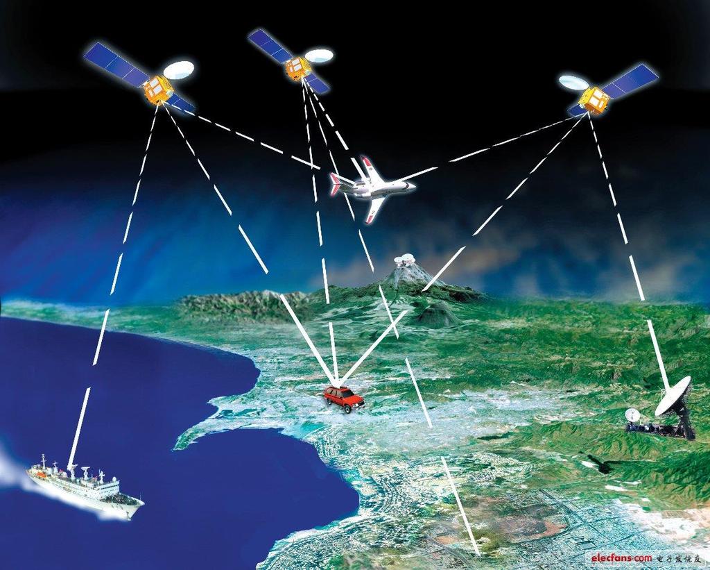
23 Space TT&C Providing TT&C support for missions such as satellite, manned spaceflight and deep space exploration. Command &control center Yuanwang instrumentation ship Ground station

24 1.National Space Infrastructure Medium and Long Term Development Plan for National Space Infrastructure( )which plans to build a world integration space facility that serving users in remote sensing, communication and broadcasting, navigation and other services in the next 10 years, Providing strong information support for national modernization and sustainable development of economy and society.

25 2 Overall Framework and Development Objectives Development Objectives To establish major framework of national civil space infrastructure, operational satellite development pattern, service mechanism and national data policy To establish three systems including satellite remote sensing, satellite communication, satellite navigation and positioning; To establish national civil space infrastructure system providing continuous and stable operation services; To complete data share service mechanism, provide standard regulation system, establish commercialization development pattern with the ability of international services To establish an advanced, global and effective national civil space infrastructure system; To achieve internationally advanced level for business, marketing, industrial development; To gradually improve mechanism of innovation driving, requirement guiding, market configuration; To strongly support economy and society development, effectively participate in internationalization development 2015 or Beyond 中国空间技术研究院通信卫星事业部 25
26 3 Construction of Remote Sensing, Communication, Navigation and Positioning Satellite System Remote Sensing Satellite System According to the development concept of multiple usage of one satellite, network of multiple satellites, coordination of multiple networks, based on the technological characteristics and user requirements characteristics of observation missions, land observation, ocean observation and atmosphere observation should be developed for focus, with the construction of remote sensing satellite system composed of seven constellations and three sorts of specific satellites. Remote sensing satellite stations network, data center, share network platform and generic application supporting platform should be constructed, global receiving and services ability of remote sensing satellite data can be developed. 中国空间技术研究院通信卫星事业部 26
27 3 Construction of Remote Sensing, Communication, Navigation and Positioning Satellite System Remote Sensing Satellite System -Space System Land, ocean and atmosphere series satellites should be manufactured, gradually developing the comprehensive and effective global observation capability with a reasonable configuration of high, medium and low resolution, as well as an optimal portfolio of multiple observation methods. 1 Land Observation: construction of three observation constellations of high resolution optical, medium resolution optical and SAR, as well as development of earth physical field satellite. 2 Ocean Observation: construction of ocean color and ocean dynamic satellite constellation, as well as ocean monitoring satellite. 3 Atmosphere Observation: construction of weather observation and climate observation satellite constellation, and atmosphere composition investigation satellite 中国空间技术研究院通信卫星事业部 27

28 3 Construction of Remote Sensing, Communication, Navigation and Positioning Satellite System Remote Sensing Satellite System-Ground System According to the requirements of effective networking, cooperative operation, integrated services, using the existing resources of ground resources, to construct ground facilities such as remote sensing satellite receiving stations network, data center, generic application supporting platform, share network platform and so on. 中国空间技术研究院通信卫星事业部 28
29 3 Construction of Remote Sensing, Communication, Navigation and Positioning Satellite System Remote Sensing Satellite System-Ground System Receiving Stations Network To coordinate all sorts of requirements, establish domestic and polar low earth orbit, polar orbit antenna, as well as receiving facility at sea, to realize coordination among multiple stations and integrative receiving for global data Data Center To upgrade existing land, ocean, weather satellite data center, support with each other, promote effective usage and share of satellite, data, calculating resource Generic Application Supporting Platform hare Network Platform Including public supporting platform for calibration and verification field network, generic technology development To connect three data centers and all levels of application systems, distribute satellite operation status and user observation requirements in time, effectively use all sorts of calculating and data resource, providing business services for users 中国空间技术研究院通信卫星事业部 29

30 3 Construction of Remote Sensing, Communication, Navigation and Positioning Satellite System Communication Satellite System Aiming at industrial and market application, focusing on commercialization, guaranteeing commonweal requirements, to develop fixed communication satellites and mobile communication satellites, synchronously construct ground facilities such as TT&C station, gateway station, uplink station, calibration field and so on, achieve services abilities of broadband communication, fixed communication, DTH, mobile communication, mobile multimedia broadcasting. To gradually construct global satellite communication and broadcasting system combining communication network covering worldwide main regions, provide services for Broadband China and Globalization strategy, promote international propagate ability. 中国空间技术研究院通信卫星事业部 30


31 3 Construction of Remote Sensing, Communication, Navigation and Positioning Satellite System Communication Satellite System-Space System To construct three sorts of satellites including fixed communication, DTH and broadband communication, provide fixed communication and broadcasting services for the country, neighborhood and other regions. Fixed Communication Satellite Focusing on the industrial requirements of telecommunication, broadcasting and TV, ocean, petroleum, based on the current satellites in-orbit, to rapidly develop fixed communication satellite system and maintain continuous improvement of fixed communication capability DTH Satellite To develop DTH satellite system on the current basis for the purpose of DTH realization Broadband Communication Satellite To develop broadband communication satellite system with broadcasting and digital distribution capability for twoway communication business such as remote education, telemedicine, rural and agriculture informatization, internationalization development and so on 中国空间技术研究院通信卫星事业部 31

32 3 Construction of Remote Sensing, Communication, Navigation and Positioning Satellite System Navigation and Positioning System Satellite navigation space system and ground system construction belongs to nation s science and technology major project of China s second generation satellite navigation system. By 2020, Beidou global satellite navigation system of 35 satellites will be completed, with positioning accuracy of 10m, timing accuracy of 20ns. 中国空间技术研究院通信卫星事业部 32
33 3 Construction of Remote Sensing, Communication, Navigation and Positioning Satellite System Government R&D Government Operational PPP Commercial Climate Change, Global Warming, Ecological Balance, Atmosphere Environment Monitoring, Grain Yield assessment, C&CO2 discharge, Ocean Salinity Observation etc. Meteorological, Ocean, Land Observation, Surveying and Mapping High Resolution Earth Observation, Multimedia Satellite Broadcasting Earth observation, Global Communication 中国空间技术研究院通信卫星事业部 33
34 4 Active Promotion on Major Applications According to business requirements and specific application objectives, to use diverse constellations, different series of satellite and data resources, construct satellite comprehensive application system and realize continuous acquirement and application multiple resource information. Resource, Environment and Ecological Protection Disaster Mitigation and Emergency Response Society Management, Public Service and Safe Production New Urbanization and Regional Sustainable Development, Integration Across Areas Mass Information Consumption and Industrialization Global Observation and Earth System Science Internationaliz ation Service and Application 中国空间技术研究院通信卫星事业部 34


35 5 Policies and Measures on International Cooperation Encourage of Internation alization Developme nt To study the specific measures of internationalization development, promote the utilization of domestic and foreign resources, domestic and foreign markets; To carry out international coordination, actively participate in related international organizations and the establishment important international regulations and standards. To extend international cooperation, carry out international cooperation on technology development, satellite development, system construction and data application; To encourage and support the construction of international cooperation comprehensive services, promote the export of satellite, data and services, improve internationalization capability and application benefits. 中国空间技术研究院通信卫星事业部 35
36 6.Concerns Overall information flow from requirement extract to satisfy Product From the requirement of standard Product and to its final Public benefit Commercial service Observation index service to customer, a Nature flow Standard Scale Industry Multi Satellites and Multi Systems Payload observation 36
37 Overall information flow from requirement extract to satisfy Product From the requirement of standard Product and to its final Public benefit Commercial service Observation index service to customer, a Nature flow Standard Scale Industry Multi Satellites and Multi Systems Payload observation 37
38 Maturity level of products and its influence to system Airship,H AP Airplane Ground observat ion Experiment Satellite Government R&D Government Operational Commercial Maturity level of Application Technology Research modelling and algorithm Research on technology method Pre Study of system R&D of system Operational Industrialized Support to Pre study Phase R&D to Operational Support to Requirement and Mission analysis 38
39 cognitive process product level level name Identification 0-2 Data grade product recognition confirmation 3 Image grade product Understanding evaluation 4 5 Target remote sensing properties Target physical properties prediction 6 Target feature level product 39

40 7.Global Contribution China has signed more than 100 space cooperation agreements with 30 countries, space agencies and international organizations.signed agreements with APSCO and UN on earth observation data sharing.


41 7.Global Contribution The Chinese government has always attached great significance to global contribution of its space system. CNSA is willing to share our experiences and achievements from space technology, science and application with other nations and organizations.

42 Merci! Wang Cheng China National Space Administration
Brief introduction on Chinese ocean colour satellite missions
 卫星海洋环境动力学国家重点实验室 Brief introduction on Chinese ocean colour satellite missions Zhihua Mao, Delu Pan State Key Laboratory of Satellite Ocean Environment Dynamics, Second Institute of Oceanography, SOA 卫星海洋环境动力学国家重点实验室国家海洋局第二海洋研究所
Shenzhou-7 Mission and Beyond -----from Imagination to Reality. Chinese Society of Astronautics
 Shenzhou-7 Mission and Beyond -----from Imagination to Reality Chinese Society of Astronautics Development Course of Chinese Manned Spaceflight Shenzhou-7 Spaceship Mission and Features The Future Development
Current and Future Meteorological Satellite Program of China
 Current and Future Meteorological Satellite Program of China ZHANG Wenjian, DONG Chaohua XU Jianmin, YANG Jun China Meteorological Administration May 30, 2005 Beijing, CHINA Outline of the Presentation
SOME ASPECT AND PERSPECTIVES OF IMPLEMENTATION OF THE NATIONAL POLICY IN THE FIELD OF EXPLORATION AND PEACEFUL USES OF OUTER SPACE
 SOME ASPECT AND PERSPECTIVES OF IMPLEMENTATION OF THE NATIONAL POLICY IN THE FIELD OF EXPLORATION AND PEACEFUL USES OF OUTER SPACE 1 Folie 1 NKS Raumfahrt, Dr. Adrian klein Background National Academy
Water Body Extraction Research Based on S Band SAR Satellite of HJ-1-C
 Cloud Publications International Journal of Advanced Remote Sensing and GIS 2016, Volume 5, Issue 2, pp. 1514-1523 ISSN 2320-0243, Crossref: 10.23953/cloud.ijarsg.43 Research Article Open Access Water
(CSES) Introduction for China Seismo- Electromagnetic Satellite
 Introduction for China Seismo- Electromagnetic Satellite") Introduction for China Seismo- Electromagnetic Satellite (CSES) Wang Lanwei Working Group of China Earthquake-related related Satellites Mission China Earthquake Administration Outline Project Objectives
Introduction for China Seismo- Electromagnetic Satellite (CSES) Wang Lanwei Working Group of China Earthquake-related related Satellites Mission China Earthquake Administration Outline Project Objectives
Drafting Committee for the Asia Pacific Plan of Action for Space Applications for Sustainable Development ( ) Republic of Korea
 Republic of Korea") Drafting Committee for the Asia Pacific Plan of Action for Space Applications for Sustainable Development (2018 2030) Republic of Korea Bangkok, Thailand 31 May 1 June 2018 김 1 KARI Introduction Government
Drafting Committee for the Asia Pacific Plan of Action for Space Applications for Sustainable Development (2018 2030) Republic of Korea Bangkok, Thailand 31 May 1 June 2018 김 1 KARI Introduction Government
DIGITAL EARTH: BRIDGING THE SCALES FROM GLOBAL TO LOCAL FOR SUSTAINABLE DEVELOPMENT
 DIGITAL EARTH: BRIDGING THE SCALES FROM GLOBAL TO LOCAL FOR SUSTAINABLE DEVELOPMENT GUO Huadong WANG Changlin Institute of Remote Sensing Applications Chinese Academy of Sciences P.O. Box 9718, Beijing
Futrajaya, Malaysia JULY 12, Jeong Heon SONG. Korea Aerospace Research Institution
 J P T M 2 0 1 1 Futrajaya, Malaysia JULY 12, 2011 Jeong Heon SONG Korea Aerospace Research Institution Outline Contribution of KARI Sentinel Asia / Data Provider Node International Charter KARI Space Activities
Geospatial Vision and Policies Korean Industry View 26 November, 2014 SI Imaging Services
 Geospatial Vision and Policies Korean Industry View 26 November, 2014 SI Imaging Services Distribution Limitation, SI Imaging Services Proprietary Data : The data contained in this document, without the
IKONOS High Resolution Multispectral Scanner Sensor Characteristics
 High Spatial Resolution and Hyperspectral Scanners IKONOS High Resolution Multispectral Scanner Sensor Characteristics Launch Date View Angle Orbit 24 September 1999 Vandenberg Air Force Base, California,
Evolving International Regulation on Satellite Services
 Evolving International Regulation on Satellite Services Inter-Agency Meeting on Outer Space Activities 2017 Mitsuhiro Sakamoto Radiocommunication Bureau International Telecommunication Union IMPORTANCE
Indian Remote Sensing Satellites
 Resourcesat-1 Indian Remote Sensing Satellites -Current & Future Resourcesat Missions - Presented by: Timothy J. Puckorius Chairman & CEO EOTec 1 Presentation Topics India s Earth Observation Heritage
NASA Spectrum Management Update: WRC-11 Issues and Objectives and Domestic Concerns
 NASA Spectrum Management Update: WRC-11 Issues and Objectives and Domestic Concerns CORF Spring Meeting May 27, 2009 John Zuzek NASA Remote Sensing Spectrum Manager Agenda Overview WRC-11 Issues of Primary
Iridium NEXT SensorPODs: Global Access For Your Scientific Payloads
 Iridium NEXT SensorPODs: Global Access For Your Scientific Payloads 25 th Annual AIAA/USU Conference on Small Satellites August 9th 2011 Dr. Om P. Gupta Iridium Satellite LLC, McLean, VA, USA Iridium 1750
China's Space Activities (2000) (November 2000)
 (November 2000)") China's Space Activities (2000) (November 2000) Foreword I. Aims and Principles II. Present Situation Space Technology Space Applications Space Science III. Future Development Development Targets Development
China's Space Activities (2000) (November 2000) Foreword I. Aims and Principles II. Present Situation Space Technology Space Applications Space Science III. Future Development Development Targets Development
Dimov Stojče Ilčev. CNS Systems
 Stratospheric Platform Systems (SPS) Presentation by: Dimov Stojče Ilčev Durban University of Technology (DUT) Space Science Centre (SSC) CNS Systems August 2011 SPS for Mobile CNS Applications Stratospheric
NON-PHOTOGRAPHIC SYSTEMS: Multispectral Scanners Medium and coarse resolution sensor comparisons: Landsat, SPOT, AVHRR and MODIS
 NON-PHOTOGRAPHIC SYSTEMS: Multispectral Scanners Medium and coarse resolution sensor comparisons: Landsat, SPOT, AVHRR and MODIS CLASSIFICATION OF NONPHOTOGRAPHIC REMOTE SENSORS PASSIVE ACTIVE DIGITAL
China Manned Space Flight Program
 China Manned Space Flight Program its present and future Wang Zhonggui,, Dong Nengli, Zhai Zhigang 15-10-2009, Korea Overview Brief Introduction Shenzhou-7 EVA Mission Development in Future Brief Introduction
Microwave Sensors Subgroup (MSSG) Report
 Report") Microwave Sensors Subgroup (MSSG) Report Feb 17-20, 2014, ESA ESRIN, Frascati, Italy DONG, Xiaolong, MSSG Chair National Space Science Center Chinese Academy of Sciences (MiRS,NSSC,CAS) Email: dongxiaolong@mirslab.cn
Microwave Sensors Subgroup (MSSG) Report Feb 17-20, 2014, ESA ESRIN, Frascati, Italy DONG, Xiaolong, MSSG Chair National Space Science Center Chinese Academy of Sciences (MiRS,NSSC,CAS) Email: dongxiaolong@mirslab.cn
The studies began when the Tiros satellites (1960) provided man s first synoptic view of the Earth s weather systems.
 provided man s first synoptic view of the Earth s weather systems.") Remote sensing of the Earth from orbital altitudes was recognized in the mid-1960 s as a potential technique for obtaining information important for the effective use and conservation of natural resources.
Remote sensing of the Earth from orbital altitudes was recognized in the mid-1960 s as a potential technique for obtaining information important for the effective use and conservation of natural resources.
Application of GPS and Remote Sensing Image Technology in Construction Monitoring of Road and Bridge
 2017 3rd International Conference on Social Science, Management and Economics (SSME 2017) ISBN: 978-1-60595-462-2 Application of GPS and Remote Sensing Image Technology in Construction Monitoring of Road
(updates from last Plenary) AS Kiran Kumar ISRO, INDIA
 AS Kiran Kumar ISRO, INDIA") ISRO s EARTH OBSERVATION SYSTEM (updates from last Plenary) AS Kiran Kumar ISRO, INDIA The 24 th CEOS Plenary Rio de Janeiro, Brazil 12 15 October, 2010 1 Four Decades of Indian Space Programme 30 LV Missions
ISRO s EARTH OBSERVATION SYSTEM (updates from last Plenary) AS Kiran Kumar ISRO, INDIA The 24 th CEOS Plenary Rio de Janeiro, Brazil 12 15 October, 2010 1 Four Decades of Indian Space Programme 30 LV Missions
The Role of Communication Technologies in Connected and Automated Vehicles
 The Role of Communication Technologies in Connected and Automated Vehicles GE Yuming China Academy of Information and Communication Technology(CAICT) 2015.7.28 Contents 1. Introduction of CAICT 2. Chinese
Light penetration within a clear water body. E z = E 0 e -kz
 THE BLUE PLANET 1 2 Light penetration within a clear water body E z = E 0 e -kz 3 4 5 Pure Seawater Phytoplankton b w 10-2 m -1 b w 10-2 m -1 b w, Morel (1974) a w, Pope and Fry (1997) b chl,loisel and
Status of COMPASS/BeiDou Development
 Status of COMPASS/BeiDou Development Stanford s 2009 PNT Challenges and Opportunities Symposium October 21-22,2009 Cao Chong China Technical Application Association for GPS Contents 1. Basic Principles
Copernicus Introduction Lisbon, Portugal 13 th & 14 th February 2014
 Copernicus Introduction Lisbon, Portugal 13 th & 14 th February 2014 Contents Introduction GMES Copernicus Six thematic areas Infrastructure Space data An introduction to Remote Sensing In-situ data Applications
Microwave Sensors Subgroup (MSSG) Report
 Report") Microwave Sensors Subgroup (MSSG) Report CEOS WGCV-35 May 13-17, 2013, Shanghai, China DONG, Xiaolong, MSSG Chair CAS Key Laboratory of Microwave Remote Sensing National Space Science Center Chinese Academy
Microwave Sensors Subgroup (MSSG) Report CEOS WGCV-35 May 13-17, 2013, Shanghai, China DONG, Xiaolong, MSSG Chair CAS Key Laboratory of Microwave Remote Sensing National Space Science Center Chinese Academy
The Global Imager (GLI)
") The Global Imager (GLI) Launch : Dec.14, 2002 Initial check out : to Apr.14, 2003 (~L+4) First image: Jan.25, 2003 Second image: Feb.6 and 7, 2003 Calibration and validation : to Dec.14, 2003(~L+4) for
The Global Imager (GLI) Launch : Dec.14, 2002 Initial check out : to Apr.14, 2003 (~L+4) First image: Jan.25, 2003 Second image: Feb.6 and 7, 2003 Calibration and validation : to Dec.14, 2003(~L+4) for
Remote sensing radio applications/ systems for environmental monitoring
 Remote sensing radio applications/ systems for environmental monitoring Alexandre VASSILIEV ITU Radiocommunication Bureau phone: +41 22 7305924 e-mail: alexandre.vassiliev@itu.int 1 Source: European Space
- Avenues and Requisites for Successful Collaboration - Indian Space Research Organisation Department of Space Government of India
 Strengthening Regional Resilience with Geo-Information Programme on Trans-boundary Cooperation in South and South East Asia for geospatial information - Avenues and Requisites for Successful Collaboration
United nation, Vienna, 9-13 February 2015
 United nation, Vienna, 9-13 February 2015 RUSSIAN FEDERAL SPACE AGENCY In the Russian Federation, the federal agency in charge of space activities is the Russian Federal Space Agency (Roscosmos) Earth
SAR Interferometry Capabilities of Canada's planned SAR Satellite Constellation
 SAR Interferometry Capabilities of Canada's planned SAR Satellite Constellation Dirk Geudtner, Guy Séguin,, Ralph Girard Canadian Space Agency RADARSAT Follow-on Program CSA is in the middle of a Phase
EARTH OBSERVATION WITH SMALL SATELLITES
 EARTH OBSERVATION WITH SMALL SATELLITES AT THE FUCHS-GRUPPE B. Penné, C. Tobehn, M. Kassebom, H. Lübberstedt OHB-System GmbH, Universitätsallee 27-29, D-28359 Bremen, Germany www.fuchs-gruppe.com ABSTRACT
Space and Missile Systems Center
 Space and Missile Systems Center Global Positioning Systems Directorate GPS Status & Modernization Progress: Service, Satellites, Control Segment, and Military GPS User Equipment 3 Nov 2016 Col Steve Whitney,
Lecture 6: Multispectral Earth Resource Satellites. The University at Albany Fall 2018 Geography and Planning
 Lecture 6: Multispectral Earth Resource Satellites The University at Albany Fall 2018 Geography and Planning Outline SPOT program and other moderate resolution systems High resolution satellite systems
SATELLITE OCEANOGRAPHY
 SATELLITE OCEANOGRAPHY An Introduction for Oceanographers and Remote-sensing Scientists I. S. Robinson Lecturer in Physical Oceanography Department of Oceanography University of Southampton JOHN WILEY
OVERVIEW OF KOMPSAT-3A CALIBRATION AND VALIDATION
 OVERVIEW OF KOMPSAT-3A CALIBRATION AND VALIDATION DooChun Seo 1, GiByeong Hong 1, ChungGil Jin 1, DaeSoon Park 1, SukWon Ji 1 and DongHan Lee 1 1 KARI(Korea Aerospace Space Institute), 45, Eoeun-dong,
Radio Frequency Sensing from Space
 Radio Frequency Sensing from Space Edoardo Marelli ITU-R WP 7C Chairman ITU-R Seminar Manta (Ecuador) 20 September 2012 Why observing the Earth from space? Satellites orbiting around the Earth offer an
ISRO s EARTH OBSERVATION SYSTEM (updates from last Plenary) AS Kiran Kumar ISRO, INDIA
 AS Kiran Kumar ISRO, INDIA") ISRO s EARTH OBSERVATION SYSTEM (updates from last Plenary) AS Kiran Kumar ISRO, INDIA The 24 th CEOS Plenary Rio de Janeiro, Brazil 12-15 October, 2010 1 Four Decades of Indian Space Programme 30LV Missions
ISRO s EARTH OBSERVATION SYSTEM (updates from last Plenary) AS Kiran Kumar ISRO, INDIA The 24 th CEOS Plenary Rio de Janeiro, Brazil 12-15 October, 2010 1 Four Decades of Indian Space Programme 30LV Missions
XSAT Ground Segment at CRISP
 XSAT Ground Segment at CRISP LIEW Soo Chin Head of Research, CRISP http://www.crisp.nus.edu.sg 5 th JPTM for Sentinel Asia Step-2, 14-16 Nov 2012, Daejeon, Korea Centre for Remote Imaging, Sensing and
Advanced Optical Satellite (ALOS-3) Overviews
 Overviews") K&C Science Team meeting #24 Tokyo, Japan, January 29-31, 2018 Advanced Optical Satellite (ALOS-3) Overviews January 30, 2018 Takeo Tadono 1, Hidenori Watarai 1, Ayano Oka 1, Yousei Mizukami 1, Junichi
K&C Science Team meeting #24 Tokyo, Japan, January 29-31, 2018 Advanced Optical Satellite (ALOS-3) Overviews January 30, 2018 Takeo Tadono 1, Hidenori Watarai 1, Ayano Oka 1, Yousei Mizukami 1, Junichi
The Network Effect, 5G and Satellite Communications
 The Network Effect, 5G and Satellite Communications October 2017 Bruce R. Elbert President and Principal Consultant Application Technology Strategy, L.L.C. Application Technology Strategy, LLC NE 1 Network
Polar Communications & Weather (PCW) Mission. Guennadi Kroupnik, Canadian Space Agency
 Mission. Guennadi Kroupnik, Canadian Space Agency") Polar Communications & Weather (PCW) Mission Guennadi Kroupnik, Canadian Space Agency Mission Objectives Reliable communications and navigations services in the high latitudes (North of 70º) to ensure:
Polar Communications & Weather (PCW) Mission Guennadi Kroupnik, Canadian Space Agency Mission Objectives Reliable communications and navigations services in the high latitudes (North of 70º) to ensure:
VIETNAM ACADEMY OF SCIENCE AND TECHNOLOGY Vietnam National Satellite Center
 VIETNAM ACADEMY OF SCIENCE AND TECHNOLOGY Vietnam National Satellite Center Assoc. Prof. Dr. Pham Anh Tuan Director of Vietnam National Satellite Center CONTENTS 1. Strategy for research and application
Global Positioning Systems Directorate
 Space and Missile Systems Center Global Positioning Systems Directorate GPS Program Update to 8 th Stanford PNT Symposium 30 Oct 2014 Col Matt Smitham Deputy Director, GPS Directorate Global Positioning
NEXT GENERATION HYPER RESOLUTION WIDE SWATH AND MULTI_CHANNEL OPTICAL PAYLOAD FOR CBERS SERIES
 CS 2014 nternational Conference on Space ptics 7-10 ctober 2014 E GEER HPER RES WE SWH _CHE PC P FR CBERS SERES Wang Weigang 1,2 1 Beijing nstitute of Space echanics and Electricity, China. 2 anjing niversity
ROLE OF SATELLITE DATA APPLICATION IN CADASTRAL MAP AND DIGITIZATION OF LAND RECORDS DR.T. RAVISANKAR GROUP HEAD (LRUMG) RSAA/NRSC/ISRO /DOS HYDERABAD
 RSAA/NRSC/ISRO /DOS HYDERABAD") ROLE OF SATELLITE DATA APPLICATION IN CADASTRAL MAP AND DIGITIZATION OF LAND RECORDS DR.T. RAVISANKAR GROUP HEAD (LRUMG) RSAA/NRSC/ISRO /DOS HYDERABAD WORKSHOP on Best Practices under National Land Records
ROLE OF SATELLITE DATA APPLICATION IN CADASTRAL MAP AND DIGITIZATION OF LAND RECORDS DR.T. RAVISANKAR GROUP HEAD (LRUMG) RSAA/NRSC/ISRO /DOS HYDERABAD WORKSHOP on Best Practices under National Land Records
Using Freely Available. Remote Sensing to Create a More Powerful GIS
 Using Freely Available Government Data and Remote Sensing to Create a More Powerful GIS All rights reserved. ENVI, E3De, IAS, and IDL are trademarks of Exelis, Inc. All other marks are the property of
INTERNATIONAL JOURNAL OF PURE AND APPLIED RESEARCH IN ENGINEERING AND TECHNOLOGY
 INTERNATIONAL JOURNAL OF PURE AND APPLIED RESEARCH IN ENGINEERING AND TECHNOLOGY A PATH FOR HORIZING YOUR INNOVATIVE WORK SATELLITE COMMUNICATION AND ITS APPLICATIONS SHEETAL RAJPUT Dept. of Computer Science
FORMOSAT-2 FOR INTERNATIONAL SOCIETAL BENEFITS
 FORMOSAT-2 FOR INTERNATIONAL SOCIETAL BENEFITS Ming-Chih Cheng 1, Celine Zhang 2 1 Researcher, 2 Research Assistant National Space Organization ABSTRACT The Group on Earth Observations (GEO), established
Update of BeiDou Navigation Satellite System
 Update of BeiDou Navigation Satellite System 01 03 Development Plan 02 Latest Progress Recent Plans 01 03 Development Plan 02 Development Objectives Basic Principles Development Steps Latest Progress System
Development of BeiDou Navigation Satellite System
 The 8 th Meeting of the International Committee on GNSS Development of BeiDou Navigation Satellite System China Satellite Navigation Office Dubai, UAE November, 2013 Contents Contents 1. Objectives and
In this unit we are going to speak about satellite communications. Satellites are useful for connecting to remote areas, or when you want to
 In this unit we are going to speak about satellite communications. Satellites are useful for connecting to remote areas, or when you want to broadcast video or data with minimal infrastructure. A communications
ITU Radiocommunication Sector (ITU-R) and Climate Change. Alexandre VASSILIEV ITU Radiocommunication Bureau
 and Climate Change. Alexandre VASSILIEV ITU Radiocommunication Bureau") ITU Radiocommunication Sector (ITU-R) and Climate Change Alexandre VASSILIEV ITU Radiocommunication Bureau WSIS FORUM 2009, Geneva, 18-22 May 2009 Radio and Information Society Today radio technologies
ITU Radiocommunication Sector (ITU-R) and Climate Change Alexandre VASSILIEV ITU Radiocommunication Bureau WSIS FORUM 2009, Geneva, 18-22 May 2009 Radio and Information Society Today radio technologies
Author s Name Name of the Paper Session. DYNAMIC POSITIONING CONFERENCE October 10-11, 2017 SENSORS SESSION. Sensing Autonomy.
 Author s Name Name of the Paper Session DYNAMIC POSITIONING CONFERENCE October 10-11, 2017 SENSORS SESSION Sensing Autonomy By Arne Rinnan Kongsberg Seatex AS Abstract A certain level of autonomy is already
FORMOSAT-5. - Launch Campaign-
 1 FORMOSAT-5 - Launch Campaign- FORMOSAT-5 Launch Campaign 2 FORMOSAT-5 Launch Campaign Launch Date: 2017.08.24 U.S. Pacific Time Activities 11:50-12:23 Launch Window 13:30-16:00 Reception 3 FORMOSAT-5
General Assembly. United Nations A/AC.105/C.1/L.335/Add.4. Draft report
 United Nations General Assembly Distr.: Limited 20 February 2014 Original: English Committee on the Peaceful Uses of Outer Space Scientific and Technical Subcommittee Fifty-first session Vienna, 10-21
REPORT ON THE STATUS OF CURRENT AND FUTURE RUSSIAN SATELLITE SYSTEMS
 Prepared by ROSH/ROSC Agenda Item: Session D Discussed in Plenary REPORT ON THE STATUS OF CURRENT AND FUTURE RUSSIAN SATELLITE SYSTEMS This document addresses the current status of the satellite systems:
746A27 Remote Sensing and GIS. Multi spectral, thermal and hyper spectral sensing and usage
 746A27 Remote Sensing and GIS Lecture 3 Multi spectral, thermal and hyper spectral sensing and usage Chandan Roy Guest Lecturer Department of Computer and Information Science Linköping University Multi
ABSTRACT. Keywords: ESSP, Earth Venture, program management, NASA Science Mission Directorate, Class-D mission, Instrument-first 1.
 SSC14-VI-10 Opportunities for Small Satellites in NASA s Earth System Science Pathfinder (ESSP) Program Frank Peri, Richard, C. Law, James E. Wells NASA Langley Research Center, 9 Langley Boulevard, Hampton,
Current and Future Missions to the Moon
 Current and Future Missions to the Moon a compilation of artist renderings by: Andrew Hay Kaguya Sep 2007 - Sep 2008 Chang'e 1 Oct 2007 - Oct 2008 Chandrayaan-1 SMART-1 Sep 2003 - Sep 2006 Oct 2008 - Oct
Intersatellite Calibration of infrared sensors onboard Indian Geostationary Satellites using LEO Hyperspectral Observations
 Updates from GSICS members and Observers Indian Space Research Organisation (ISRO) Intersatellite Calibration of infrared sensors onboard Indian Geostationary Satellites using LEO Hyperspectral Observations
Soil moisture retrieval using ALOS PALSAR
 Soil moisture retrieval using ALOS PALSAR T. J. Jackson, R. Bindlish and M. Cosh USDA ARS Hydrology and Remote Sensing Lab, Beltsville, MD J. Shi University of California Santa Barbara, CA November 6,
Lecture 1 Introduction to Remote Sensing
 Lecture 1 Introduction to Remote Sensing Dr Ian Leiper School of Environmental and Life Sciences Bldg Purple 12.2.27 1 2 Lecture Outline Introductions Unit admin Learning outcomes Unit outline Practicals
Space Debris Mitigation Status of China s Launch Vehicle
 Space Debris Mitigation Status of China s Launch Vehicle SONG Qiang (Beijing Institute of Aerospace Systems Engineering) Abstract: China s launch vehicle has being developed for more than 40 years. Various
Exploration Partnership Strategy. Marguerite Broadwell Exploration Systems Mission Directorate
 Exploration Partnership Strategy Marguerite Broadwell Exploration Systems Mission Directorate October 1, 2007 Vision for Space Exploration Complete the International Space Station Safely fly the Space
9/12/2011. Training Course Remote Sensing Basic Theory & Image Processing Methods September 2011
 Training Course Remote Sensing Basic Theory & Image Processing Methods 19 23 September 2011 Remote Sensing Platforms Michiel Damen (September 2011) damen@itc.nl 1 Overview Platforms & missions aerial surveys
GLOBAL SATELLITE SYSTEM FOR MONITORING
 MEETING BETWEEN YUZHNOYE SDO AND HONEYWELL, International Astronautical Congress IAC-2012 DECEMBER 8, 2009 GLOBAL SATELLITE SYSTEM FOR MONITORING YUZHNOYE SDO PROPOSALS FOR COOPERATION WITH HONEYWELL EARTH
STRATEGIC CHOICES FOR SMALL AND MIDDLE POWERS
 Chapter Five STRATEGIC CHOICES FOR SMALL AND MIDDLE POWERS SPACE DEVELOPMENT IN KOREA Hong-Yul Paik, Director, Satellite Operation Center, Korea Aerospace Research Institute, South Korea Korea is a young
Invitation to Participate
 Invitation to Participate JOIN US IN THE UNLIMITED RESILIENT DIGITAL CONNECTIVITY Invitation to Participate The Global Space Economy is worth more than $400 billion and set to grow dramatically. The SmartSat
Indian Remote Sensing Satellites
 Resourcesat-1 Cartosat-1 Indian Remote Sensing Satellites -Current & Future Missions - Presented by: Timothy J. Puckorius Chairman & CEO EOTec 1 Presentation Topics Who is EOTec India s Earth Observation
Baumanets student micro-satellite
 Baumanets student micro-satellite Presentation at UNIVERSAT 2006 International Symposium June 28, 2006 Moscow, Russia Victoria Mayorova Director of Youth Space Center of Bauman Moscow State Technical University
New Thrust in Indian Space Programme
 New Thrust in Indian Space Programme A Glance Dr. M Annadurai Director, ISRO Satellite Centre International Technical Meet on Quality Assurance Jan 2018 Vision: Harness space technology for national development
Ghazanfar A. Khattak National Centre of Excellence in Geology University of Peshawar
 INTRODUCTION TO REMOTE SENSING Ghazanfar A. Khattak National Centre of Excellence in Geology University of Peshawar WHAT IS REMOTE SENSING? Remote sensing is the science of acquiring information about
14 February 2011 Japan
 Concerning to the ToR on the Long-Term Sustainability of Outer Space Activities of the STSC (A/AC.105/C.1/L.307) Procedure for Risk Assessment & Identification of Best Practices to Support the WG for Sustainability
Important Missions. weather forecasting and monitoring communication navigation military earth resource observation LANDSAT SEASAT SPOT IRS
 Fundamentals of Remote Sensing Pranjit Kr. Sarma, Ph.D. Assistant Professor Department of Geography Mangaldai College Email: prangis@gmail.com Ph. No +91 94357 04398 Remote Sensing Remote sensing is defined
The Sounding Instruments on Second Generation of Chinese Meteorological Satellite FY-3
 The Sounding Instruments on Second Generation of Chinese Meteorological Satellite FY-3 DONG Chaohua ZHANG Wenjian National Satellite Meteorological Center China Meteorological Administration Beijing 100081,
ESA Climate Change Initiative- Soil Moisture (CCI SM): Serving our users lessons for Copernicus Climate Change Service
: Serving our users lessons for Copernicus Climate Change Service") ESA Climate Change Initiative- Soil Moisture (CCI SM): Serving our users lessons for Copernicus Climate Change Service Dr Eva Haas, GeoVille & Richard Kidd, EODC ESA CCI Soil Moisture Overview of project
ESA Climate Change Initiative- Soil Moisture (CCI SM): Serving our users lessons for Copernicus Climate Change Service Dr Eva Haas, GeoVille & Richard Kidd, EODC ESA CCI Soil Moisture Overview of project
EXPERIENCE OF PARTICIPATION IN INTERNATIONAL SCIENTIFIC AND EDUCATIONAL SPACE PROJECTS BY THE EXAMPLE OF QB50 PROJECT
 EXPERIENCE OF PARTICIPATION IN INTERNATIONAL SCIENTIFIC AND EDUCATIONAL SPACE PROJECTS BY THE EXAMPLE OF QB50 PROJECT Postgraduate student of Inter-University Space Research Department Denis Davydov Samara,
Satellite and GPS technology
 Satellite and GPS technology Maryna Strydom (GIS Tg SA) Tel: (011) 441 6163 mstrydom@srk.co.za Overview General How Earth Observation Satellites work Uses of different EOS outputs How GPS work Types of
OVERVIEW OF THE ALOS SATELLITE SYSTEM
 OVERVIEW OF THE ALOS SATELLITE SYSTEM Presented to The Symposium for ALOS Data Application Users @Kogakuin University, Tokyo, Japan Mar. 27, 2001 Takashi Hamazaki Senior Engineer ALOS Project National
High Resolution Sensor Test Comparison with SPOT, KFA1000, KVR1000, IRS-1C and DPA in Lower Saxony
 High Resolution Sensor Test Comparison with SPOT, KFA1000, KVR1000, IRS-1C and DPA in Lower Saxony K. Jacobsen, G. Konecny, H. Wegmann Abstract The Institute for Photogrammetry and Engineering Surveys
An Introduction to Geomatics. Prepared by: Dr. Maher A. El-Hallaq خاص بطلبة مساق مقدمة في علم. Associate Professor of Surveying IUG
 An Introduction to Geomatics خاص بطلبة مساق مقدمة في علم الجيوماتكس Prepared by: Dr. Maher A. El-Hallaq Associate Professor of Surveying IUG 1 Airborne Imagery Dr. Maher A. El-Hallaq Associate Professor
The STU-2 CubeSat Mission and In-Orbit Test Results
 30 th Annual AIAA/USU Conference on Small Satellite SSC16-III-09 The STU-2 CubeSat Mission and In-Orbit Test Results Shufan Wu, Wen Chen, Caixia Chao Shanghai Engineering Centre for Microsatellites 99
Govt. Engineering College Jhalawar Model Question Paper Subject- Remote Sensing & GIS
 Govt. Engineering College Jhalawar Model Question Paper Subject- Remote Sensing & GIS Time: Max. Marks: Q1. What is remote Sensing? Explain the basic components of a Remote Sensing system. Q2. What is
SPACE TECHNOLOGY IN MONGOLIA
 United Nations/United Arab Emirates High Level Forum Space as a driver for socio-economic sustainable development 20 24 November 2016 SPACE TECHNOLOGY IN MONGOLIA Ms.Oyuntsetseg.B Deputy Director of Space
U.S. Space Exploration in the Next 20 NASA Space Sciences Policy
 U.S. Space Exploration in the Next 20 ScienceYears: to Inspire, Science to Serve NASA Space Sciences Policy National Aeronautics and Space Administration Waleed Abdalati NASA Chief Scientist Waleed Abdalati
Overview of the Small Optical TrAnsponder (SOTA) Project
 Project") Overview of the Small Optical TrAnsponder (SOTA) Project Space Communications Laboratory Wireless Networks Research Center National Institute of Information and Communications Technology (NICT) Satellite
Overview of the Small Optical TrAnsponder (SOTA) Project Space Communications Laboratory Wireless Networks Research Center National Institute of Information and Communications Technology (NICT) Satellite
An insight in the evolution of GEO satellite technologies for broadband services
 An insight in the evolution of GEO satellite technologies for broadband services EUROPEAN SATELLITE INDUSTRY ROADMAP MARCH 14 TH, BRUSSELS Future broadband technologies 1/2 2 The need for informing the
Title: Development of Microsatellite in Monitoring Initial Harmful Algae Bloom (HAB) HAB-M Primary Point of Contact (POC) & TAN AIK KWAN
 HAB-M Primary Point of Contact (POC) & TAN AIK KWAN") Title: Development of Microsatellite in Monitoring Initial Harmful Algae Bloom (HAB) HAB-M Primary Point of Contact (POC) & email: TAN AIK KWAN (tonyehmd1995@gmail.com) Co-authors: QX Chan, JY Low, YC
Title: Development of Microsatellite in Monitoring Initial Harmful Algae Bloom (HAB) HAB-M Primary Point of Contact (POC) & email: TAN AIK KWAN (tonyehmd1995@gmail.com) Co-authors: QX Chan, JY Low, YC
On the use of water color missions for lakes in 2021
 Lakes and Climate: The Role of Remote Sensing June 01-02, 2017 On the use of water color missions for lakes in 2021 Cédric G. Fichot Department of Earth and Environment 1 Overview 1. Past and still-ongoing
PASSIVE MICROWAVE PROTECTION
 PASSIVE MICROWAVE PROTECTION RESULTS OF WRC-07 DISASTER MANGEMENT FUTURE WORK FOR WRC-11, RFI INTERFERENCE ON SATELLITE PASSIVE OBSERVATIONS Jean PLA CNES, Toulouse, France Frequency manager 1 Agenda items
NRS 415 Remote Sensing of Environment
 NRS 415 Remote Sensing of Environment 1 High Oblique Perspective (Side) Low Oblique Perspective (Relief) 2 Aerial Perspective (See What s Hidden) An example of high spatial resolution true color remote
Introduction. Satellite Research Centre (SaRC)
") SATELLITE RESEARCH CENTRE - SaRC Introduction The of NTU strives to be a centre of excellence in satellite research and training of students in innovative space missions. Its first milestone satellite
SATELLITE RESEARCH CENTRE - SaRC Introduction The of NTU strives to be a centre of excellence in satellite research and training of students in innovative space missions. Its first milestone satellite
Operation and Development of BeiDou Navigation Satellite System
 Operation and Development of BeiDou Navigation Satellite System Jing Li IAIN 2015, 20 23 October Prague, Czech Republic 2 01 03 Plan and Policy 02 Status and Near-term Goal International Cooperation 3
ITU/WMO Seminar Use of Radio Spectrum for Meteorology: Weather, Water and Climate Monitoring and Prediction
 ITU/WMO Seminar Use of Radio Spectrum for Meteorology: Weather, Water and Climate Monitoring and Prediction Session 5: Meteorological Aids Service (Radiosondes( Radiosondes) ) and Other Systems 5.1.1 MetAids)
AIREON SPACE-BASED ADS-B
 AIREON SPACE-BASED ADS-B 2018 Transport Canada Delegates Conference Steve Bellingham Manager, Navigation Systems Engineering Steve.Bellingham@navcanada.ca CNS/ATM Systems Communication Navigation Surveillance
Ozobot Bit. Computer Science Engineering Program
 3 rd Grade Ozobot Bit Computer Science Engineering Program Post Visit Activity Resources 2018 Winter/Spring 2018 Dear Third Grade Visiting Classroom Teacher, It is hoped that you and your students enjoyed
Sustained Ocean Color Research and Operations
 Sustained Ocean Color Research and Operations What are the minimum requirements to continue the SeaWiFS/MODIS time-series? Based on a National Research Council report by the Ocean Studies Board May 2011