Microwave Radiometer calibration with GPS radio occultation for the MiRaTA CubeSat mission
|
|
|
- Peregrine Crawford
- 5 years ago
- Views:
Transcription
1 Microwave Radiometer calibration with GPS radio occultation for the MiRaTA CubeSat mission K. Cahoy, MIT AeroAstro W. Blackwell, MIT Lincoln Laboratory A. Marinan, MIT AeroAstro N. Erickson, UMass-Amherst R. Bishop, The Aerospace Corporation T. Neilsen, Space Dynamics Laboratory B. Dingwall, NASA Wallops Flight Facility November 4, 2016 This work is sponsored by the National Aeronautics and Space Administration. Opinions, interpretations, conclusions, and recommendations are those of the authors and are not necessarily endorsed by the United States Government.

, temporal, and radiometric 1University Center for Atmospheric Research")
2 Our Ability to Predict the Weather Has Profound Societal and Economic Implications The US derives $32 B of value from weather forecasts annually1 Earth observing satellites drive the forecasts Eternal quest for resolution: Spatial (vertical and horizontal), temporal, and radiometric 1University Center for Atmospheric Research NEROC- 2

3 Satellites Provide the Most Forecast Skill Microwave sounding Infrared sounding Infrared sounding Airborne obs GPS radio occultation Weather balloon Radar Weather balloon Water vapor sounding Infrared imaging Infrared sounding Drifting buoy Airborne obs Infrared sounding Infrared imaging Water vapor sounding Microwave imaging Microwave imaging Infrared imaging Infrared imaging Infrared imaging Infrared imaging Infrared imaging Ozone Passive microwave observations have the highest impact Bigger is better NEROC- 3
4 Microwave Atmospheric Sensing Wavelength (meters) Radio Microwave Infrared Visible Ultraviolet X-ray Gamma Ray x Cloud Penetration; Highest Forecast Impact Transmission (%) Frequency (GHz) The frequency dependence of atmospheric absorption allows different altitudes to be sensed by spacing channels along absorption lines NEROC- 4
 MicroMAS Satellite Advanced Technology Microwave")

 Modest pointing requirements Relatively low data rate")
5 New Approach for Microwave Sounding Suomi NPP Satellite (Launched Oct. 2011) MicroMAS Satellite Advanced Technology Microwave Sounder (ATMS) 4.2 kg, 10W, 34 x 10 x 10 cm 100 kg, 100 W Microwave sensor amenable to miniaturization (10 cm aperture) Broad footprints (~50 km) Modest pointing requirements Relatively low data rate 2100 kg NASA/GSFC NPP: National Polar-orbiting Partnership NEROC- 5

6 Enabling the Next Generation: MicroMAS-1, MicroMAS-2, and MiRaTA MicroMAS = Microsized Microwave Atmospheric Satellite MiRaTA = Microwave Radiometer Technology Acceleration MicroMAS-1 3U cubesat with 118-GHz radiometer 8 channels for temperature measurements July 2014 launch, March 2015 release; validation of spacecraft systems; eventual transmitter failure MicroMAS-2 3U cubesat scanning radiometer with channels near 90, 118, 183, and 206 GHz 12 channels for moisture and temperature profiling and precipitation imaging Two launches in 2017 MiRaTA 3U cubesat with 60, 183, and 206 GHz radiometers and GPS radio occultation 10 channels for temperature, moisture, and cloud ice measurements Early 2017 launch on JPSS-1 NEROC- 6
 MicroMAS-1 MicroMAS-2 MiRaTA TROPICS 3U cubesat with 118-GHz radiometer 8 channels for temperature measurements July 2014 launch, March")
7 Next Generation: Constellations MicroMAS = Microsized Microwave Atmospheric Satellite MiRaTA = Microwave Radiometer Technology Acceleration Time-Resolved Observations of Precipitation structure and storm Intensity with a Constellation of Smallsats (TROPICS) MicroMAS-1 MicroMAS-2 MiRaTA TROPICS 3U cubesat with 118-GHz radiometer 8 channels for temperature measurements July 2014 launch, March 2015 release; validation of spacecraft systems; eventual transmitter failure 3U cubesat scanning radiometer with channels near 90, 118, 183, and 206 GHz 12 channels for moisture and temperature profiling and precipitation imaging Two launches in U cubesat with 60, 183, and 206 GHz radiometers and GPS radio occultation 10 channels for temperature, moisture, and cloud ice measurements Early 2017 launch on JPSS-1 Selected for EVI-3 12 CubeSats (3U) in three orbital planes (600km/30 ) Temperature and moisture profiling and cloud ice measurements 30-minute revisit 2019/2020 launch NEROC- 7
8 Microwave Radiometer Technology Acceleration (MiRaTA) 3U (10 cm x 10 cm x 34 cm) tri-band radiometer - Temperature, water vapor, and cloud ice - ~60 GHz (temperature) - ~183 GHz (humidity) - ~207 GHz (cloud ice) - Absolute calibration better than 1 K Calibration proof of concept using limb measurements and GPS-RO - 60, 183, and 206 GHz; OEM628 GPS Funded by NASA Earth Science Technology Office (ESTO) InVEST program ~30-month build 4.5 kg total mass 10 W avg power 10 kbps max data rate 0.5 pointing accuracy Launch in early 2017 (JPSS-1) - Permits direct comparisons with ATMS NEROC- 8
9 TRL Advancement Criteria (TRL 5 to 7) (1) IF spectrometer Verify that the V-band radiometric accuracy is within 1.5 K of the truth predictions V-band end-to-end receiver temperature sufficient to yield 0.1K NEdT. Blackwell ACT10 Hyperspectral Microwave Receiver IFP module leveraged here (2) G-band mixer 2.0 K radiometric accuracy against ground truth predictions End-to-end receiver temperature sufficient to yield 0.25 K NEdT. Blackwell ACT10 Hyperspectral Microwave Receiver mixer module leveraged here (3) GPS-RO receiver Evaluate GPS-RO temperature retrievals are within 1.5 K of the truth predictions Truth measurements consist of combination of radiosondes and NWP measurements coupled with radiative transfer model Direct radiance comparisons with operational passive microwave sounders will also be utilized for verification NEROC- 9


10 MiRaTA Calibration Maneuver ~ 10 minute maneuver 0.5 / sec rate NEROC- 10
 & Weston Marlow (G95 & SSL)")
11 MiRaTA Pitch-Up Maneuver Objective: Collocate radiometric data and GPS RO temperature profile Credit: Annie Marinan (MIT SSL) & Weston Marlow (G95 & SSL) NEROC- 11
12 GPS-RO Opportunities for One Day NEROC- 12 Setting GPS satellite, < 25 km tangent height

13 NEROC- 13 MiRaTA Sensor Viewing Geometries
")
14 MiRaTA Spacecraft Overview Payload Microwave Radiometer GPS Radio Occultation receiver and Patch Antenna array (GPSRO or CTAGS) Bus Cadet UHF Radio with Monopole UHF Antenna Avionics Stack With low data-rate UHF radio and antenna Attitude Determination and Control System Power system, batteries Radiometer & GPS Receiver Radiometer IFP/PIM Avionics, Comm & Power Stack X Z Y Monopole Antennas (2) Solar Panel Arrays ADCS EHS (2&3) EHS (1) Payload Solar Panel Arrays NEROC- 14


15 MiRaTA Space Vehicle Overview UHF antenna EHS OEM628 GPS Receiver Radiometer EHS = Earth Horizon Sensor ADCS = Attitude Determination and Control System GPSRO = Global Positioning System Radio Occultation IFP = Intermediate Frequency Processor PIM = Payload Interface Module GPSRO Avionics Stack IFP/PIM Assembly MAI ADCS Unit NEROC- 15

16 NEROC- 16 Systems: MiRaTA System Block Diagram


 Custom")


17 Custom Top Interface Board L-3 Cadet Bus Flight Hardware Micron Motherboard (custom) Custom Micron Radio Clyde Space Electrical Power System ADCS MAI-400 IMU Clyde Space Battery Custom Bottom Interface Board NEROC- 17
18 Radiometer Payload: Block Diagram Payload Voltage Regulator Module V-band Receiver Front End Local Oscillator (DRO) Intermediate Frequency Processor Payload Interface Module G-RFE-1 G-RFE-2 NEROC- 18
19 NEROC- 19 Payload: Radiometer Receiver Front End

20 MiRaTA Radiometer System Reflector Shroud Antenna Reflector V-band feed-waveguide assembly G-band feed-waveguide assembly G-band Mixer Module G-band Calibration Module V-band Receiver Front End Dielectric Resonant Oscillator NEROC- 20 All flight radiometer hardware delivered


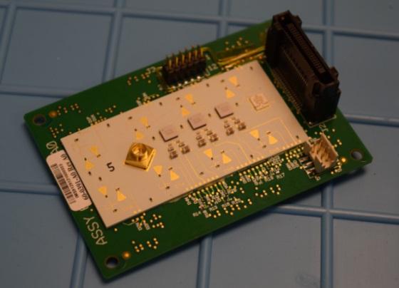

21 Radiometer Flight Hardware DRO PVRM V-RFE PIM Reflector, feedhorns, & V-RFE G-RFE-1 V-IFP G-IFP NEROC- 21 G-RFE-2


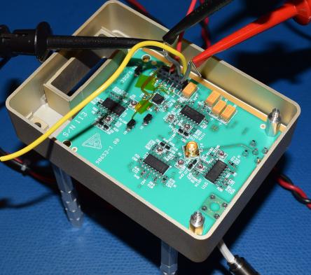
22 CTAGS Overview Provided by Aerospace Corp. to retrieve temperature profiles using GPS radio occultation (Dr. Rebecca Bishop) Aerospace performed TVac testing, vibration testing, & onorbit simulations Delivered flight and flight spare in Mar GPS Patch Antenna Patch antenna pattern OEM628 GPS Receiver Low Noise Amplifier NEROC- 22 Compact Total-Electron-Count and Atmospheric GPS Sensor (CTAGS)
 in 50 km footprint needed to improve forecast accuracy Six or more channels")
 Ultracompact spectrometer funded by NASA ESTO (ACT-10) Receiver front-end")


23 Measurement Requirements and Enabling Technologies Temperature profile uncertainty of 2 K (RMS) in 50 km footprint needed to improve forecast accuracy Six or more channels Sensitivity better than 0.3 K (RMS) Ultracompact spectrometer funded by NASA ESTO (ACT-10) Receiver front-end electronics developed by UMass-Amherst Low-temperature co-fired ceramic filters MMIC low-noise amplifiers and electronic calibration Operation from GHz NEROC- 23 Calibration accuracy better than 1 K (RMS) Noise diode source provides periodic absolute calibration of radiometer Highly stable; compact Aperture ~9 cm Beam efficiency > 95% Offset parabolic reflector system with scalar feed Lightweight, with RMS surface tolerance
24 NEROC- 24 Channel Properties for MiRaTA Radiometers
25 Advantage of Limb Comparisons GPS-RO sweet spot NEROC- 25
26 MiRaTA Product Validation Approach Level 0 Data Products Level 1b Data Products Level 2 Data Products Blackwell, et al 2014 [4] MiRaTA Radiometer Data Products Radiometer Raw Data Lvl 0 Calibration & Geolocation Radiometer Radiance Data Lvl 1b Radiometer Radiance Accuracy Collocate & Difference NWP Radiances Data Radiometer Radiative Transfer Model NWP Atmospheric Truth Data Marinan, This Paper et al., 2016 MiRaTA Radiometer Calibration Approach CTAGS Profile Accuracy Collocate & Difference MiRaTA CTAGS Data Products CTAGS Raw Data Lvl 0 Bending Angle Retrieval & Geolocation CTAGS Bending Angle Data Lvl 1b Refractivity & Profile Retrievals CTAGS Profiles Lvl 2 Algorithm Data set Metric NEROC- 26
27 Approach Co-located Radiometer and GPSRO Want to calibrate radiometer data using overlapping GPSRO measurements Execute a slow pitch (~ 0.5 /sec) maneuver once per orbit with a goal of obtaining > 100 spatially and temporally coincident radiometer and GPSRO scans of Earth s limb over a 90-day mission. For absolute radiometer calibration accuracy better than 0.25 K (50-60 GHz band), need: GPSRO temperature precision better than 1.5 K (0.5 K goal) GPSRO penetration to 20 km tangent height within 100 km of radiometer boresight NEROC- 27

28 NEROC- 28 MiRaTA GPSRO Data Processing Flow
29 Deriving Temperature Precision Based on method presented by Hajj et al., 2002 Kursinski, 1997 Hinson, 2010 Note: Radiometer calibration calculations done by Lincoln Laboratory NEROC- 29
! is the integration time!\"!! (W/W) is the power signal to noise ratio based on a 1-second integration time (!\"!! =!\"!!!!, where!\"!!! is the voltage signal to noise ratio in a vacuum) The 1-second L1 SNRv of the receiver is 271 V/V (174 V/V for L2) NEROC- 30")
30 Deriving Temperature Precision Antenna Gain: 9.7 db (L1), 9.4 db (L2) From the receiver datasheet, 0.5 mm phase precision at 20 Hz!!!!! is the rms phase error (units of length)! is the sampling frequency (L1 or L2)! is the integration time!"!! (W/W) is the power signal to noise ratio based on a 1-second integration time (!"!! =!"!!!!, where!"!!! is the voltage signal to noise ratio in a vacuum) The 1-second L1 SNRv of the receiver is 271 V/V (174 V/V for L2) NEROC- 30
31 Deriving Temperature Precision From free-space SNR and atmospheric loss, calculate Fresnel zone (~1.4 km) Determine time it takes for signal to travel one Fresnel zone Recalculate phase precision based on integration time For the receiver!"!!! the average Fresnel zone value for MiRaTA is 1.4 km. The average integration time for the MiRaTA orbit (440 km x 811 km) is 0.5s This corresponds to a 0.16 mm phase precision (0.32 mm for L2) T = 2Z F /V = integration time Z F = Fresnel zone diameter λ= sampling wavelength D t = distance from tangent point to Tx D r = distance from tangent point to Rx V = vertical rate of link NEROC- 31
32 Deriving Temperature Precision Doppler noise calculated from phase precision Neutral bending angle calculation takes into account both L1 and L2 NEROC- 32
33 Deriving Temperature Precision Abel transform converts bending angle to atmospheric refractivity Bending angle (exponential with height) represented with power-law approximation Abel transform of power law has analytic solution Calculate contribution of numerical calculation to retrieval error Several orders of magnitude below expected measurement errors lnµ j = 1 θ ( a)da π a 2 2 a j a j µ = refractivity θ = bending angle a = impact factor NEROC- 33
34 Deriving Temperature Precision From refractivity, get air density Integrate density to get pressure Ideal gas law for temperature Propagate bending angle error through all calculations to derive temperature error Best-fit: ~0.5 degrees at 20 km 95% confidence: degrees at 20 km NEROC- 34
35 Path Forward (MiRaTA) Identify how many overlapping observations we can acquire over the mission lifetime (mission requirement: 100) Preliminary results (over 3 months) > 500 overlapping accesses 5-6 opportunities per day MiRaTA ADCS driving additional satellite rotation that may impact the total number of overlapping occultations Estimate how many might fall within required temperature precision (most likely a Monte Carlo approach) NEROC- 35

![(km): [400 500 600 700] Inclination (deg): [0 30 60 98] Numbers of](/docs-images/86/93206692/images/36-5.jpg "satellites: [1 3 6] Satellite Altitude Satellite Inclination GPS")
")

36 CubeSat GPSRO Global Coverage Approach External Input: GPSRO antenna 60 deg HPBW External Inputs Max Gain Gain Pattern Field of View Altitude (km): [ ] Inclination (deg): [ ] Numbers of satellites: [1 3 6] Satellite Altitude Satellite Inclination GPS Position and Velocity Access Calculations Parametric Model Lookup table with: - Total number of occultations - Angle of accesses (mean, std dev) - Range of accesses (mean, std dev) For various altitudes and inclinations Access Intervals Numbers of Occultations Revisit Rate Link Budget Analysis NEROC- 36
37 Access Opportunities for GPSRO by Orbit Percent Time with >= 4 GPS Satellites in View Driven by requirement for position knowledge and reference satellites Total number of occultation opportunities Assuming 60 degree HPBW receiving antenna field of view Analysis run over 3 months (Jan Apr 2016) across tradespace of orbit parameters 400 km 500 km 600 km 700 km 400 km 500 km 600 km 700 km 0 80% 84% 87% 89% % 63% 66% 69% % 65% 68% 71% % 72% 75% 77% %Time (out of 3 months) with 4 GPS satellites in view Number of GPS RO occultation opportunities below 200 km tangent height In general, equatorial or polar orbits (i.e. not mid-latitude) offer more GPS access and occultation opportunities NEROC- 37

 One satellite Three Satellites")
38 Revisits, Multiple GPSRO Satellites per Plane Moving toward weekly/daily measurement updates (ideally hourly revisits) One satellite Three Satellites Six Satellites NEROC- 38


39 Testing Overview CTAGS Interface Test Solar Panel Deployment Test Integrated Test Antenna Tuning & Isolation Test NEROC- 39


40 ADCS Testing Overview Earth Horizon Sensor Blackbody Response Test Magnetorquer Test Magnetometer Testing in Helmholtz Cage Magnetometer Test Earth Horizon Sensor Narrow & wide FOV Characterization NEROC- 40


41 Space Vehicle Fit Checks Deployer Fit Check Mass mockup CTAGS Antenna Fit Check EM Solar Panel Fit Check NEROC- 41 Volume & mass risks are low, but with slim margins


42 MiRaTA Manifested on ELaNa 14 Launch on a Delta II with JPSS-1 Inclination degrees Orbit ~811km x ~440km LTAN - 13:20:35 JPSS-1 launch in Jan NEROC- 42
43 MiRaTA Key Dates Milestone Date Award Start Dec. 20, 2013 NSSC Approval Feb. 12, 2014 Funds distributed Mar. 14, 2014 Project Kickoff with Subs Apr System Requirements Review June 2, 2014 System PDR Oct. 22, 2014 System CDR June 1-3, 2015 Flight-ready Spacecraft Integrated Oct. 26, 2016 Deadline to complete testing reports Nov. 11, 2016 Mission Readiness Review Dec. 6, 2016 CubeSat Delivery Jan. 10, 2017 Launch March, 2017* * ELaNa-XIV launch with JPSS-1 NEROC- 43
44 Summary MiRaTA will provide multi-band radiometry and GPS-RO in a single 3U cubesat Temperature, moisture, and cloud ice with high absolute accuracy Flight hardware build is complete, system testing underway TVAC complete, currently undergoing vibration and shock test March 2017 launch on JPSS-1 MiRaTA is a critical pathfinder for the TROPICS constellation Multi-band radiometry Electronic calibration Spacecraft maneuvers for mission capability NEROC- 44
45 MiRaTA V-band Front-End Performance (Includes PIN Switch and Noise Injection) Rcvr Temp Noise Diode Temp NEROC- 45
46 NEROC- 46 MiRaTA G-band Front-End Performance
Microwave Radiometers for Small Satellites
 Microwave Radiometers for Small Satellites Gregory Allan, Ayesha Hein, Zachary Lee, Weston Marlow, Kerri Cahoy MIT STAR Laboratory Daniel Cousins, William J. Blackwell MIT Lincoln Laboratory This work
New Small Satellite Capabilities for Microwave Atmospheric Remote Sensing: The Earth Observing Nanosatellite- Microwave (EON-MW)
") New Small Satellite Capabilities for Microwave Atmospheric Remote Sensing: The Earth Observing Nanosatellite- Microwave (EON-MW) W. Blackwell, D. Cousins, and L. Fuhrman MIT Lincoln Laboratory August 6,
New Small Satellite Capabilities for Microwave Atmospheric Remote Sensing: The Earth Observing Nanosatellite- Microwave (EON-MW) W. Blackwell, D. Cousins, and L. Fuhrman MIT Lincoln Laboratory August 6,
Integration and Test of the Microwave Radiometer Technology Acceleration (MiRaTA) CubeSat
 CubeSat") Integration and Test of the Microwave Radiometer Technology Acceleration (MiRaTA) CubeSat Kerri Cahoy, Gregory Allan, Ayesha Hein, Andrew Kennedy, Zachary Lee, Erin Main, Weston Marlow, Thomas Murphy MIT
Integration and Test of the Microwave Radiometer Technology Acceleration (MiRaTA) CubeSat Kerri Cahoy, Gregory Allan, Ayesha Hein, Andrew Kennedy, Zachary Lee, Erin Main, Weston Marlow, Thomas Murphy MIT
Microwave Sounding. Ben Kravitz October 29, 2009
 Microwave Sounding Ben Kravitz October 29, 2009 What is Microwave Sounding? Passive sensor in the microwave to measure temperature and water vapor Technique was pioneered by Ed Westwater (c. 1978) Microwave
Hyper-spectral, UHD imaging NANO-SAT formations or HAPS to detect, identify, geolocate and track; CBRN gases, fuel vapors and other substances
 Hyper-spectral, UHD imaging NANO-SAT formations or HAPS to detect, identify, geolocate and track; CBRN gases, fuel vapors and other substances Arnold Kravitz 8/3/2018 Patent Pending US/62544811 1 HSI and
CIRiS: Compact Infrared Radiometer in Space August, 2017
 1 CIRiS: Compact Infrared Radiometer in Space August, 2017 David Osterman PI, CIRiS Mission Presented by Hansford Cutlip 10/8/201 7 Overview of the CIRiS instrument and mission The CIRiS instrument is
RAX: The Radio Aurora explorer
 RAX: Matt Bennett University of Michigan CubeSat Workshop Cal Poly, San Luis Obispo April 22 nd, 2009 Background Sponsored by National Science Foundation University of Michigan and SRI International Collaboration
Passive Microwave Sensors LIDAR Remote Sensing Laser Altimetry. 28 April 2003
 Passive Microwave Sensors LIDAR Remote Sensing Laser Altimetry 28 April 2003 Outline Passive Microwave Radiometry Rayleigh-Jeans approximation Brightness temperature Emissivity and dielectric constant
DYNAMIC IONOSPHERE CUBESAT EXPERIMENT
 Geoff Crowley, Charles Swenson, Chad Fish, Aroh Barjatya, Irfan Azeem, Gary Bust, Fabiano Rodrigues, Miguel Larsen, & USU Student Team DYNAMIC IONOSPHERE CUBESAT EXPERIMENT NSF-Funded Dual-satellite Space
Outline. GPS RO Overview. COSMIC Overview. COSMIC-2 Overview. Summary 9/29/16
 Bill Schreiner and UCAR/COSMIC Team UCAR COSMIC Program Observation and Analysis Opportunities Collaborating with the ICON and GOLD Missions Sept 27, 216 GPS RO Overview Outline COSMIC Overview COSMIC-2
8th Int l Precip. Working Group & 5th Int l Workshop on Space-based Snow Measurement, Bologna, Italia
 8th Int l Precip. Working Group & 5th Int l Workshop on Space-based Snow Measurement, Bologna, Italia Time-Resolved Measurements of Precipitation from 6U-Class Satellite Constellations: Temporal Experiment
OPAL Optical Profiling of the Atmospheric Limb
 OPAL Optical Profiling of the Atmospheric Limb Alan Marchant Chad Fish Erik Stromberg Charles Swenson Jim Peterson OPAL STEADE Mission Storm Time Energy & Dynamics Explorers NASA Mission of Opportunity
Emerging Technology for Satellite Remote Sensing of Boundary Layer Clouds and their Environment
 Emerging Technology for Satellite Remote Sensing of Boundary Layer Clouds and their Environment Matt Lebsock (NASA-JPL) Contributors: Chi Ao (NASA-JPL) Tom Pagano (NASA-JPL) Amin Nehir (NASA-Langley) Where
NOAA EON-IR CubeSat Study for Operational Infrared Soundings
 NOAA EON-IR CubeSat Study for Operational Infrared Soundings Dan Mamula National Oceanic and Atmospheric Administration National Environmental Satellite, Data, and Information Service Office of Project,
Wind Imaging Spectrometer and Humidity-sounder (WISH): a Practical NPOESS P3I High-spatial Resolution Sensor
: a Practical NPOESS P3I High-spatial Resolution Sensor") Wind Imaging Spectrometer and Humidity-sounder (WISH): a Practical NPOESS P3I High-spatial Resolution Sensor Jeffery J. Puschell Raytheon Space and Airborne Systems, El Segundo, California Hung-Lung Huang
Wind Imaging Spectrometer and Humidity-sounder (WISH): a Practical NPOESS P3I High-spatial Resolution Sensor Jeffery J. Puschell Raytheon Space and Airborne Systems, El Segundo, California Hung-Lung Huang
Design of a Free Space Optical Communication Module for Small Satellites
 Design of a Free Space Optical Communication Module for Small Satellites Ryan W. Kingsbury, Kathleen Riesing Prof. Kerri Cahoy MIT Space Systems Lab AIAA/USU Small Satellite Conference August 6 2014 Problem
Kazuhiro TANAKA GCOM project team/jaxa April, 2016
 Kazuhiro TANAKA GCOM project team/jaxa April, 216 @ SPIE Asia-Pacific 216 at New Dehli, India 1 http://suzaku.eorc.jaxa.jp/gcom_c/index_j.html GCOM mission and satellites SGLI specification and IRS overview
RADIOMETRIC PERFORMANCE OF THE CRIS INSTRUMENT FOR JPSS-1
 Place image here (10 x 3.5 ) RADIOMETRIC PERFORMANCE OF THE CRIS INSTRUMENT FOR JPSS-1 RONALD GLUMB, LAWRENCE SUWINSKI, STEVEN WELLS, REBECCA MALLOY CALCON Technical Conference Logan, UT August 22-25,
CYGNSS Mission Update
 International Ocean Vector Wind Science Team Meeting Portland, OR 19-21 May 2015 CYGNSS Mission Update Chris Ruf (1) CYGNSS Principal Investigator Paul Chang (2), Maria Paola Clarizia (1), Scott Gleason
CubeSat Integration into the Space Situational Awareness Architecture
 CubeSat Integration into the Space Situational Awareness Architecture Keith Morris, Chris Rice, Mark Wolfson Lockheed Martin Space Systems Company 12257 S. Wadsworth Blvd. Mailstop S6040 Littleton, CO
The Global Imager (GLI)
") The Global Imager (GLI) Launch : Dec.14, 2002 Initial check out : to Apr.14, 2003 (~L+4) First image: Jan.25, 2003 Second image: Feb.6 and 7, 2003 Calibration and validation : to Dec.14, 2003(~L+4) for
The Global Imager (GLI) Launch : Dec.14, 2002 Initial check out : to Apr.14, 2003 (~L+4) First image: Jan.25, 2003 Second image: Feb.6 and 7, 2003 Calibration and validation : to Dec.14, 2003(~L+4) for
IT-SPINS Ionospheric Imaging Mission
 IT-SPINS Ionospheric Imaging Mission Rick Doe, SRI Gary Bust, Romina Nikoukar, APL Dave Klumpar, Kevin Zack, Matt Handley, MSU 14 th Annual CubeSat Dveloper s Workshop 26 April 2017 IT-SPINS Ionosphere-Thermosphere
CubeSat Proximity Operations Demonstration (CPOD) Mission Update Cal Poly CubeSat Workshop San Luis Obispo, CA
 Mission Update Cal Poly CubeSat Workshop San Luis Obispo, CA") CubeSat Proximity Operations Demonstration (CPOD) Mission Update Cal Poly CubeSat Workshop San Luis Obispo, CA 04-22-2015 Austin Williams VP, Space Vehicles ConOps Overview - Designed to Maximize Mission
CubeSat Proximity Operations Demonstration (CPOD) Mission Update Cal Poly CubeSat Workshop San Luis Obispo, CA 04-22-2015 Austin Williams VP, Space Vehicles ConOps Overview - Designed to Maximize Mission
I SARA 08/10/13. Pre-Decisional Information -- For Planning and Discussion Purposes Only
 1 Overview ISARA Mission Summary Payload Description Experimental Design ISARA Mission Objectives: Demonstrate a practical, low cost Ka-band High Gain Antenna (HGA) on a 3U CubeSat Increase downlink data
Cross Track Infrared Sounder (CrIS) Flight Model 1 Test Results
 Flight Model 1 Test Results") May 6, 2009 Ronald Glumb, Joseph P. Predina, Robert Hookman, Chris Ellsworth, John Bobilya, Steve Wells, Lawrence Suwinski, Rebecca Frain, and Larry Crawford For Publication at the ASS-FTS14 Conference
May 6, 2009 Ronald Glumb, Joseph P. Predina, Robert Hookman, Chris Ellsworth, John Bobilya, Steve Wells, Lawrence Suwinski, Rebecca Frain, and Larry Crawford For Publication at the ASS-FTS14 Conference
Sub-Mesoscale Imaging of the Ionosphere with SMAP
 Sub-Mesoscale Imaging of the Ionosphere with SMAP Tony Freeman Xiaoqing Pi Xiaoyan Zhou CEOS Workshop, ASF, Fairbanks, Alaska, December 2009 1 Soil Moisture Active-Passive (SMAP) Overview Baseline Mission
Chapter 3 Solution to Problems
 Chapter 3 Solution to Problems 1. The telemetry system of a geostationary communications satellite samples 100 sensors on the spacecraft in sequence. Each sample is transmitted to earth as an eight-bit
Solar Observing Low-frequency Array for Radio Astronomy (SOLARA)
") Solar Observing Low-frequency Array for Radio Astronomy (SOLARA) Exploring the last frontier of the EM spectrum Mary Knapp, Dr. Alessandra Babuscia, Rebecca Jensen-Clem, Francois Martel, Prof. Sara Seager
Solar Observing Low-frequency Array for Radio Astronomy (SOLARA) Exploring the last frontier of the EM spectrum Mary Knapp, Dr. Alessandra Babuscia, Rebecca Jensen-Clem, Francois Martel, Prof. Sara Seager
Small Satellites: The Execution and Launch of a GPS Radio Occultation Instrument in a 6U Nanosatellite
 Small Satellites: The Execution and Launch of a GPS Radio Occultation Instrument in a 6U Nanosatellite Dave Williamson Director, Strategic Programs Tyvak Tyvak: Satellite Solutions for Multiple Organizations
GNSS Reflectometry and Passive Radar at DLR
 ACES and FUTURE GNSS-Based EARTH OBSERVATION and NAVIGATION 26./27. May 2008, TU München Dr. Thomas Börner, Microwaves and Radar Institute, DLR Overview GNSS Reflectometry a joined proposal of DLR and
Microwave Remote Sensing (1)
") Microwave Remote Sensing (1) Microwave sensing encompasses both active and passive forms of remote sensing. The microwave portion of the spectrum covers the range from approximately 1cm to 1m in wavelength.
Microwave Remote Sensing (1) Microwave sensing encompasses both active and passive forms of remote sensing. The microwave portion of the spectrum covers the range from approximately 1cm to 1m in wavelength.
NanoRacks Customer Payloads on Orbital-ATK-9
 NanoRacks Customer Payloads on Orbital-ATK-9 NANORACKS CUBESAT DEPLOYER (INTERNATIONAL SPACE STATION) NASA ELaNa 23, CubeRRT Ohio State University, Columbus, Ohio 6U CubeRRT will be delivered by the Orbital
Ice-Cube: Spaceflight Validation of an 874 GHz Sub-millimeter Wave Radiometer for Ice Cloud Remote Sensing
 Ice-Cube: Spaceflight Validation of an 874 GHz Sub-millimeter Wave Radiometer for Ice Cloud Remote Sensing Jaime Esper, Dong Wu, Jeffrey Piepmeier, Negar Ehsan, Paul Racette NASA Greenbelt, MD 20771 USA
CubeSat Proximity Operations Demonstration (CPOD) Vehicle Avionics and Design
 Vehicle Avionics and Design") CubeSat Proximity Operations Demonstration (CPOD) Vehicle Avionics and Design August CubeSat Workshop 2015 Austin Williams VP, Space Vehicles CPOD: Big Capability in a Small Package Communications ADCS
CubeSat Proximity Operations Demonstration (CPOD) Vehicle Avionics and Design August CubeSat Workshop 2015 Austin Williams VP, Space Vehicles CPOD: Big Capability in a Small Package Communications ADCS
The Evolution of Nano-Satellite Proximity Operations In-Space Inspection Workshop 2017
 The Evolution of Nano-Satellite Proximity Operations 02-01-2017 In-Space Inspection Workshop 2017 Tyvak Introduction We develop miniaturized custom spacecraft, launch solutions, and aerospace technologies
DICE CubeSat Mission. Spring 2011 CubeSat Workshop April 20, 2011 Erik Stromberg,
 DICE CubeSat Mission Spring 2011 CubeSat Workshop April 20, 2011 Erik Stromberg, erik.stromberg@sdl.usu.edu The Dynamic Ionosphere CubeSat Experiment PI: Geoff Crowley, Astra DPI: Charles Swenson, Utah
Lecture Notes Prepared by Prof. J. Francis Spring Remote Sensing Instruments
 Lecture Notes Prepared by Prof. J. Francis Spring 2005 Remote Sensing Instruments Material from Remote Sensing Instrumentation in Weather Satellites: Systems, Data, and Environmental Applications by Rao,
2009 CubeSat Developer s Workshop San Luis Obispo, CA
 Exploiting Link Dynamics in LEO-to-Ground Communications 2009 CubeSat Developer s Workshop San Luis Obispo, CA Michael Caffrey mpc@lanl.gov Joseph Palmer jmp@lanl.gov Los Alamos National Laboratory Paper
Space Technology Mission Directorate. NASA's Role in Small Spacecraft Technologies: Today and in the Future
 National Aeronautics and Space Administration Space Technology Mission Directorate NASA's Role in Small Spacecraft Technologies: Today and in the Future Presented by: Jim Reuter Deputy Associate Administrator
NOAA Satellite and Information Service National Environmental Satellite, Data, and Information Service (NESDIS)
") NOAA Satellite and Information Service National Environmental Satellite, Data, and Information Service (NESDIS) Status of Current and Future Systems (NOAA-WP-33) Presentation to CGMS-40 November 2012;
NOAA Satellite and Information Service National Environmental Satellite, Data, and Information Service (NESDIS) Status of Current and Future Systems (NOAA-WP-33) Presentation to CGMS-40 November 2012;
Relative Navigation, Timing & Data. Communications for CubeSat Clusters. Nestor Voronka, Tyrel Newton
 Relative Navigation, Timing & Data Communications for CubeSat Clusters Nestor Voronka, Tyrel Newton Tethers Unlimited, Inc. 11711 N. Creek Pkwy S., Suite D113 Bothell, WA 98011 425-486-0100x678 voronka@tethers.com
COSMIC / FormoSat 3 Overview, Status, First results, Data distribution
 COSMIC / FormoSat 3 Overview, Status, First results, Data distribution COSMIC Introduction / Status Early results from COSMIC Neutral Atmosphere profiles Refractivity Temperature, Water vapor Planetary
A CubeSat-Based Optical Communication Network for Low Earth Orbit
 A CubeSat-Based Optical Communication Network for Low Earth Orbit Richard Welle, Alexander Utter, Todd Rose, Jerry Fuller, Kristin Gates, Benjamin Oakes, and Siegfried Janson The Aerospace Corporation
A view from the Global Space-based Inter- Calibration System (GSICS. Mitch Goldberg, NOAA Chair of GSICS Executive Panel
 A view from the Global Space-based Inter- Calibration System (GSICS Mitch Goldberg, NOAA Chair of GSICS Executive Panel Global Space-based Inter-Calibration System What is GSICS? Global Space-based Inter-Calibration
First Results From the GPS Compact Total Electron Content Sensor (CTECS) on the PSSCT-2 Nanosat
 on the PSSCT-2 Nanosat") First Results From the GPS Compact Total Electron Content Sensor (CTECS) on the PSSCT-2 Nanosat Rebecca Bishop 1, David Hinkley 1, Daniel Stoffel 1, David Ping 1, Paul Straus 1, Timothy Burbaker 2 1 The
First Results From the GPS Compact Total Electron Content Sensor (CTECS) on the PSSCT-2 Nanosat Rebecca Bishop 1, David Hinkley 1, Daniel Stoffel 1, David Ping 1, Paul Straus 1, Timothy Burbaker 2 1 The
Simulation Results of Alternative Methods for Formation Separation Control
 Simulation Results of Alternative Methods for Formation Separation Control Thomas Heine, Charles Bussy-Virat, Mark Moldwin, Aaron Ridley Department of Climate and Space Sciences and Engineering University
Sea surface temperature observation through clouds by the Advanced Microwave Scanning Radiometer 2
 Sea surface temperature observation through clouds by the Advanced Microwave Scanning Radiometer 2 Akira Shibata Remote Sensing Technology Center of Japan (RESTEC) Tsukuba-Mitsui blds. 18F, 1-6-1 Takezono,
Copyrighted Material. Contents
 Preface xiii 1 Introduction 1 1.1 Concepts 1 1.2 Spacecraft Sensors Cost 5 1.2.1 Introduction to Cost Estimating 5 1.2.2 Cost Data 7 1.2.3 Cost Estimating Methodologies 8 1.2.4 The Cost Estimating Relationship
Geoff Crowley, Chad Fish, Charles Swenson, Gary Bust, Aroh Barjatya, Miguel Larsen, and USU Student Team
 Geoff Crowley, Chad Fish, Charles Swenson, Gary Bust, Aroh Barjatya, Miguel Larsen, and USU Student Team NSF-Funded Dual-satellite Space Weather Mission Project Funded October 2009 (6 months ago) 1 2 11
Design and Development of a Ground-based Microwave Radiometer System
 PIERS ONLINE, VOL. 6, NO. 1, 2010 66 Design and Development of a Ground-based Microwave Radiometer System Yu Zhang 1, 2, Jieying He 1, 2, and Shengwei Zhang 1 1 Center for Space Science and Applied Research,
Microwave Sensors Subgroup (MSSG) Report
 Report") Microwave Sensors Subgroup (MSSG) Report Feb 17-20, 2014, ESA ESRIN, Frascati, Italy DONG, Xiaolong, MSSG Chair National Space Science Center Chinese Academy of Sciences (MiRS,NSSC,CAS) Email: dongxiaolong@mirslab.cn
Microwave Sensors Subgroup (MSSG) Report Feb 17-20, 2014, ESA ESRIN, Frascati, Italy DONG, Xiaolong, MSSG Chair National Space Science Center Chinese Academy of Sciences (MiRS,NSSC,CAS) Email: dongxiaolong@mirslab.cn
Outernet: Development of a 1U Platform to Enable Low Cost Global Data Provision
 Outernet: Development of a 1U Platform to Enable Low Cost Global Data Provision Introduction One of the UK s leading space companies, and the only wholly UK-owned Prime contractor. ISO 9001:2008 accredited
David M. Klumpar Keith W. Mashburn Space Science and Engineering Laboratory Montana State University
 Developing the Explorer-1 [PRIME] Satellite for NASA s ELaNa CubeSat Launch Program David M. Klumpar Keith W. Mashburn Space Science and Engineering Laboratory Montana State University Outline E1P Mission
3. Radio Occultation Principles
 Page 1 of 6 [Up] [Previous] [Next] [Home] 3. Radio Occultation Principles The radio occultation technique was first developed at the Stanford University Center for Radar Astronomy (SUCRA) for studies of
Microwave-Radiometer
 Microwave-Radiometer Figure 1: History of cosmic background radiation measurements. Left: microwave instruments, right: background radiation as seen by the corresponding instrument. Picture: NASA/WMAP
Radiometer Calibration Using Colocated GPS Radio Occultation Measurements
 Radiometer Calibration Using Colocated GPS Radio Occultation Measurements The MIT Faculty has made this article openly available. Please share how this access benefits you. Your story matters. Citation
Typical technical and operational characteristics of Earth exploration-satellite service (passive) systems using allocations between 1.
 systems using allocations between 1.") Recommendation ITU-R RS.1861 (01/2010) Typical technical and operational characteristics of Earth exploration-satellite service (passive) systems using allocations between 1.4 and 275 GHz RS Series Remote
Recommendation ITU-R RS.1861 (01/2010) Typical technical and operational characteristics of Earth exploration-satellite service (passive) systems using allocations between 1.4 and 275 GHz RS Series Remote
New Synergistic Opportunities for Magnetosphere-Ionosphere-Thermosphere Coupling Investigations Using Swarm and CASSIOPE e-pop
 New Synergistic Opportunities for Magnetosphere-Ionosphere-Thermosphere Coupling Investigations Using Swarm and CASSIOPE e-pop Andrew W. Yau 1, R. Floberghagen 2, Leroy L. Cogger 1, Eelco N. Doornbos 3,
The Colorado Student Space Weather Experiment (CSSWE) On-Orbit Performance
 On-Orbit Performance") The Colorado Student Space Weather Experiment (CSSWE) On-Orbit Performance David Gerhardt 1, Scott Palo 1, Xinlin Li 1,2, Lauren Blum 1,2, Quintin Schiller 1,2, and Rick Kohnert 2 1 University of Colorado
The Colorado Student Space Weather Experiment (CSSWE) On-Orbit Performance David Gerhardt 1, Scott Palo 1, Xinlin Li 1,2, Lauren Blum 1,2, Quintin Schiller 1,2, and Rick Kohnert 2 1 University of Colorado
RECOMMENDATION ITU-R S *
 Rec. ITU-R S.1339-1 1 RECOMMENDATION ITU-R S.1339-1* Rec. ITU-R S.1339-1 SHARING BETWEEN SPACEBORNE PASSIVE SENSORS OF THE EARTH EXPLORATION-SATELLITE SERVICE AND INTER-SATELLITE LINKS OF GEOSTATIONARY-SATELLITE
NASA s Earth Science Technology Office CubeSats for Technology Maturation
 NASA s Earth Science Technology Office CubeSats for Technology Maturation Charles D. Norton NASA HQ Earth Science Technology Office (ESTO) Jet Propulsion Laboratory, California Institute of Technology
RADIATION BUDGET INSTRUMENT (RBI): FINAL DESIGN AND INITIAL EDU TEST RESULTS
: FINAL DESIGN AND INITIAL EDU TEST RESULTS") Place image here (10 x 3.5 ) RADIATION BUDGET INSTRUMENT (RBI): FINAL DESIGN AND INITIAL EDU TEST RESULTS RONALD GLUMB, JAY OVERBECK, CHRISTOPHER LIETZKE, JOHN FORSYTHE, ALAN BELL, AND JASON MILLER NON-EXPORT
Place image here (10 x 3.5 ) RADIATION BUDGET INSTRUMENT (RBI): FINAL DESIGN AND INITIAL EDU TEST RESULTS RONALD GLUMB, JAY OVERBECK, CHRISTOPHER LIETZKE, JOHN FORSYTHE, ALAN BELL, AND JASON MILLER NON-EXPORT
3/31/03. ESM 266: Introduction 1. Observations from space. Remote Sensing: The Major Source for Large-Scale Environmental Information
 Remote Sensing: The Major Source for Large-Scale Environmental Information Jeff Dozier Observations from space Sun-synchronous polar orbits Global coverage, fixed crossing, repeat sampling Typical altitude
LE/ESSE Payload Design
 LE/ESSE4360 - Payload Design 4.3 Communications Satellite Payload - Hardware Elements Earth, Moon, Mars, and Beyond Dr. Jinjun Shan, Professor of Space Engineering Department of Earth and Space Science
NCUBE: The first Norwegian Student Satellite. Presenters on the AAIA/USU SmallSat: Åge-Raymond Riise Eystein Sæther
 NCUBE: The first Norwegian Student Satellite Presenters on the AAIA/USU SmallSat: Åge-Raymond Riise Eystein Sæther Motivation Build space related competence within: mechanical engineering, electronics,
2009 Small Satellite Conference Logan, Utah
 Exploiting Link Dynamics in LEO-to-Ground Communications 2009 Small Satellite Conference Logan, Utah Joseph Palmer jmp@lanl.gov Michael Caffrey mpc@lanl.gov Los Alamos National Laboratory Paper Abstract
Submillimeter-Wave Spectrometer for Small Satellites VAST: Venus Atmospheric Sounder with Terahertz
 Submillimeter-Wave Spectrometer for Small Satellites VAST: Venus Atmospheric Sounder with Terahertz Theodore Reck, Brian Drouin, Adrian Tang, Cecile Jung-Kubiak, Imran Mehdi Vesper Goddard managed Venus
Air Force Institute of Technology. A CubeSat Mission for Locating and Mapping Spot Beams of GEO Comm-Satellites
 Air Force Institute of Technology A CubeSat Mission for Locating and Mapping Spot Beams of GEO Comm-Satellites Lt. Jake LaSarge PI: Dr. Jonathan Black Dr. Brad King Dr. Gary Duke August 9, 2015 1 Outline
A CubeSat Radio Beacon Experiment
 A CubeSat Radio Beacon Experiment CUBEACON A Beacon Test of Designs for the Future Antenna? Michael Cousins SRI International Multifrequency? Size, Weight and Power? CubeSat Developers Workshop, April
Radiometric performance of Second Generation Global Imager (SGLI) using integrating sphere
 using integrating sphere") Radiometric performance of Second Generation Global Imager (SGLI) using integrating sphere Taichiro Hashiguchi, Yoshihiko Okamura, Kazuhiro Tanaka, Yukinori Nakajima Japan Aerospace Exploration Agency
Radiometric performance of Second Generation Global Imager (SGLI) using integrating sphere Taichiro Hashiguchi, Yoshihiko Okamura, Kazuhiro Tanaka, Yukinori Nakajima Japan Aerospace Exploration Agency
Design and Functional Validation of a Mechanism for Dual-Spinning CubeSats
 Design and Functional Validation of a Mechanism for Dual-Spinning CubeSats Eric Peters, Pratik Davé, Ryan Kingsbury, Meghan Prinkey, Anne Marinan, Evan Wise, Christopher Pong, Kerri Cahoy, William Thalheimer,
Resolving Tropical Storm Inner Core Temperatures with a Three-Meter Geostationary Microwave Sounder
 Resolving Tropical Storm Inner Core Temperatures with a Three-Meter Geostationary Microwave Sounder Donald Chu a, Norman Grody b, Michael Madden c a Swales Aerospace, 55 Powder Mill Road, Beltsville, MD
Global Environmental MEMS Sensors (GEMS): Revolutionary Observing Technology for the 21st Century
: Revolutionary Observing Technology for the 21st Century") Global Environmental MEMS Sensors (GEMS): Revolutionary Observing Technology for the 21st Century NIAC Phase I CP-01-02 John Manobianco, Randolph J. Evans, Jonathan L. Case, David A. Short ENSCO, Inc.
Global Environmental MEMS Sensors (GEMS): Revolutionary Observing Technology for the 21st Century NIAC Phase I CP-01-02 John Manobianco, Randolph J. Evans, Jonathan L. Case, David A. Short ENSCO, Inc.
B ==================================== C
 Satellite Space Segment Communication Frequencies Frequency Band (GHz) Band Uplink Crosslink Downlink Bandwidth ==================================== C 5.9-6.4 3.7 4.2 0.5 X 7.9-8.4 7.25-7.7575 0.5 Ku 14-14.5
Large, Deployable S-Band Antenna for a 6U Cubesat
 Physical Sciences Inc. VG15-073 Large, Deployable S-Band Antenna for a 6U Cubesat Peter A. Warren, John W. Steinbeck, Robert J. Minelli Physical Sciences, Inc. Carl Mueller Vencore, Inc. 20 New England
SNIPE mission for Space Weather Research. CubeSat Developers Workshop 2017 Jaejin Lee (KASI)
") SNIPE mission for Space Weather Research CubeSat Developers Workshop 2017 Jaejin Lee (KASI) New Challenge with Nanosatellites In observing small-scale plasma structures, single satellite inherently suffers
SNIPE mission for Space Weather Research CubeSat Developers Workshop 2017 Jaejin Lee (KASI) New Challenge with Nanosatellites In observing small-scale plasma structures, single satellite inherently suffers
The Nemo Bus: A Third Generation Nanosatellite Bus for Earth Monitoring and Observation
 The Nemo Bus: A Third Generation Nanosatellite Bus for Earth Monitoring and Observation FREDDY M. PRANAJAYA Manager, Advanced Systems Group S P A C E F L I G H T L A B O R A T O R Y University of Toronto
ECE Lecture 32
 ECE 5010 - Lecture 32 1 Microwave Radiometry 2 Properties of a Radiometer 3 Radiometric Calibration and Uncertainty 4 Types of Radiometer Measurements Levis, Johnson, Teixeira (ESL/OSU) Radiowave Propagation
Profiling Radiometer for Atmospheric and Cloud Observations PRACO
 Profiling Radiometer for Atmospheric and Cloud Observations PRACO Boulder Environmental Sciences and Technology BEST Small startup company, established in 2006 Focused on radiometry ground based and airborne
Phoenix. A 3U CubeSat to Study Urban Heat Islands. Sarah Rogers - Project Manager NASA Space Grant Symposium April 14, 2018
 Phoenix A 3U CubeSat to Study Urban Heat Islands Sarah Rogers - Project Manager NASA Space Grant Symposium April 14, 2018 Phoenix Overview Undergraduate-led 3U CubeSat to study Urban Heat Islands through
Altimeter Range Corrections
 Altimeter Range Corrections Schematic Summary Corrections Altimeters Range Corrections Altimeter range corrections can be grouped as follows: Atmospheric Refraction Corrections Sea-State Bias Corrections
Introduction to Radar Systems. Radar Antennas. MIT Lincoln Laboratory. Radar Antennas - 1 PRH 6/18/02
 Introduction to Radar Systems Radar Antennas Radar Antennas - 1 Disclaimer of Endorsement and Liability The video courseware and accompanying viewgraphs presented on this server were prepared as an account
Iridium NEXT SensorPODs: Global Access For Your Scientific Payloads
 Iridium NEXT SensorPODs: Global Access For Your Scientific Payloads 25 th Annual AIAA/USU Conference on Small Satellites August 9th 2011 Dr. Om P. Gupta Iridium Satellite LLC, McLean, VA, USA Iridium 1750
Wallops CubeSat-SmallSat Ground Stations and Frequency Standardization
 Wallops CubeSat-SmallSat Ground Stations and Frequency Standardization Scott Schaire with contributions from Serhat Altunc, Wayne Powell, Ben Malphrus August, 2013 Wallops UHF on left, S-Band on right
Global System For Monitoring Earth Radiation Balance
 Global System For Monitoring Earth Radiation Balance Presentation to NIAC Fellows Meeting 19 October 2004 Seattle, WA Aaron Buys, John Vander Weide, and Llian Breen Dr. Matthew K. Heun Calvin College,
Using the Radio Spectrum to Understand Space Weather
 Using the Radio Spectrum to Understand Space Weather Ray Greenwald Virginia Tech Topics to be Covered What is Space Weather? Origins and impacts Analogies with terrestrial weather Monitoring Space Weather
Deployable Helical Antenna for Nano- Satellites
 Deployable Helical Antenna for Nano- Satellites Patent Pending 28 th AIAA/USU Small Sat Conference Wednesday August 6 th 2014, Author: Daniel Ochoa Product Development Manager, Co-authors: Kenny Hummer,
Worst-Case GPS Constellation for Testing Navigation at Geosynchronous Orbit for GOES-R
 Worst-Case GPS Constellation for Testing Navigation at Geosynchronous Orbit for GOES-R Kristin Larson, Dave Gaylor, and Stephen Winkler Emergent Space Technologies and Lockheed Martin Space Systems 36
ECE Satellite Radar TRMM Precipitation Radar Cloud mm Radar - Cloudsat. Tropical Rainfall Measuring Mission
 Tropical Rainfall Measuring Mission ECE 583 18 Satellite Radar TRMM Precipitation Radar Cloud mm Radar - Cloudsat -TRMM includes 1st spaceborne weather radar - performs cross-track scan to get 3-D view
A Scalable Deployable High Gain Reflectarray Antenna - DaHGR
 A Scalable Deployable High Gain Reflectarray Antenna - DaHGR Presented by: P. Keith Kelly, PhD MMA Design LLC 1 MMA Overview Facilities in Boulder County Colorado 10,000 SF facility Cleanroom / Flight
Prepared by IROWG 18 September 2013 IROWG/DOC/2013/01
 CRITICAL IMPACT OF THE POTENTIAL DELAY OR DESCOPING OF THE COSMIC-2/FORMOSAT-7 PROGRAMME Assessment by the IROWG, September 2013 1. Introduction The 41 st session of the Coordination Group for Meteorological
The NaoSat nanosatellite platform for in-flight radiation testing. Jose A Carrasco CEO EMXYS Spain
 Jose A Carrasco CEO EMXYS Spain Presentation outline: - Purpose and objectives of EMXYS NaoSat plattform - The Platform: service module - The platform: payload module and ICD - NaoSat intended missions
Application of radiative transfer to slanted line-of-sight geometry and comparisons with NASA EOS Aqua data
 Application of radiative transfer to slanted line-of-sight geometry and comparisons with NASA EOS Aqua data Paul Poli (1), Joanna Joiner (2), and D. Lacroix (3) 1 Centre National de Recherches Météorologiques
NOAA Satellite and Information Service
 NOAA Satellite and Information Service Dr. Stephen Volz, Assistant Administrator NESDIS Program Overview and Decadal Survey Priorities ESAS2017 Steering Committee Meeting January 20, 2016 NOAA Satellite
Status of MOLI development MOLI (Multi-footprint Observation Lidar and Imager)
") Status of MOLI development MOLI (Multi-footprint Observation Lidar and Imager) Tadashi IMAI, Daisuke SAKAIZAWA, Jumpei MUROOKA and Toshiyoshi KIMURA JAXA 1 Outline of This Presentation 1. Overview of MOLI
Status of MOLI development MOLI (Multi-footprint Observation Lidar and Imager) Tadashi IMAI, Daisuke SAKAIZAWA, Jumpei MUROOKA and Toshiyoshi KIMURA JAXA 1 Outline of This Presentation 1. Overview of MOLI
Current and Future Meteorological Satellite Program of China
 Current and Future Meteorological Satellite Program of China ZHANG Wenjian, DONG Chaohua XU Jianmin, YANG Jun China Meteorological Administration May 30, 2005 Beijing, CHINA Outline of the Presentation
An overview of the COSMIC follow-on mission (COSMIC-II) and its potential for GNSS-R
 and its potential for GNSS-R") An overview of the COSMIC follow-on mission (COSMIC-II) and its potential for GNSS-R Lidia Cucurull (1), Dave Ector (2), and Estel Cardellach (3) (1) NOAA/NWS/NCEP/EMC (2) NOAA/NESDIS/OSD (3) IEEC/ICE-CSIC
An overview of the COSMIC follow-on mission (COSMIC-II) and its potential for GNSS-R Lidia Cucurull (1), Dave Ector (2), and Estel Cardellach (3) (1) NOAA/NWS/NCEP/EMC (2) NOAA/NESDIS/OSD (3) IEEC/ICE-CSIC
SPACE. (Some space topics are also listed under Mechatronic topics)
") SPACE (Some space topics are also listed under Mechatronic topics) Dr Xiaofeng Wu Rm N314, Bldg J11; ph. 9036 7053, Xiaofeng.wu@sydney.edu.au Part I SPACE ENGINEERING 1. Vision based satellite formation
SPACE (Some space topics are also listed under Mechatronic topics) Dr Xiaofeng Wu Rm N314, Bldg J11; ph. 9036 7053, Xiaofeng.wu@sydney.edu.au Part I SPACE ENGINEERING 1. Vision based satellite formation
SATELLITE OCEANOGRAPHY
 SATELLITE OCEANOGRAPHY An Introduction for Oceanographers and Remote-sensing Scientists I. S. Robinson Lecturer in Physical Oceanography Department of Oceanography University of Southampton JOHN WILEY
NOAA s CubeSat-Related Activities for Gap Mitigation and Future Planning
 SSC17-VI-04 NOAA s CubeSat-Related Activities for Gap Mitigation and Future Planning John Pereira, Dan Mamula, Margaret Caulfield, Daniel St Jean, Frank Gallagher, Sid Boukabara, and Kevin Tewey NOAA /