Co-location on Ground and in Space; GGOS Core Site
|
|
|
- Felicia Moody
- 5 years ago
- Views:
Transcription

1 Co-location on Ground and in Space; GGOS Core Site Michael Pearlman/CfA Harald Schuh/TUW Erricos Pavlis/UMBC Unified Analysis Workshop Zurich, Switzerland September 16 17, 2011

2 NRC Report Precise Geodetic Infrastructure Courtesy of Bernard Minster Courtesy of Bernard Minster 10/01/2010 NRC Briefing 1 Co-location on Ground and in Space; GGOS Space Core Geodesy Sites GGOS Networks Unified to Improve Analysis the Workshop, ITRF EGU Zurich 2011, September Vienna April 16-17, 2011
3 The Geodetic Reference Frame (International Terrestrial Reference Frame) Basis for measuring change over space, time and evolving technology Requirement (Source GGOS 2020): <1 mm reference frame accuracy < 0.1 mm/yr stability Measurement of sea level is the primary driver Improvement over current ITRF performance by a factor of Means of providing the reference frame: Global Network of co-located VLBI/SLR/GNSS/DORIS CORE SITES define the reference frame Dense network of GNSS stations to distribute the reference frame globally to the users Users anywhere on the Earth can position their measurements in the reference frame This work is being done by the GGOS Bureau for Networks and Communication with the assistance of the the GGOS InterAqency Committtee (GIAC)
 A ground site with co-located SLR, VLBI, GNSS and DORIS (where available) so that their measurements can be related to sub-mm accuracy Why do we need multiple techniques?")
4 What is a Core Site? (Terrestrial Reference Frame) A ground site with co-located SLR, VLBI, GNSS and DORIS (where available) so that their measurements can be related to sub-mm accuracy Why do we need multiple techniques? Measurement requirements are very stringent Each technique makes its measurements in a different way and therefore each measures something a little different: Terrestrial (satellite) verses celestial (quasar) reference Range verses range difference measurements Broadcast up verses broadcast down Radio verses optical Active verses passive Geographic coverage Each technique has different strengths and weaknesses The combination allows us to take advantage of the strengths and mitigate the weaknesses

5 Simulation Studies to Scope the Network of Core Sites (Fundamental Stations) (Erricos Pavlis) 30 Core Sites required to satisfy reference frame requirements Globally well distributed; Proper conditions; Modern technology; Operate routinely; Day/Night SLR tracking on GNSS complexes to calibrate the GNSS orbits;
6 SLR+VLBI Networks (with SLR/VLBI Co-locations noted) 7 SLR/VLBI co-location sites operating All co-locations sites have GNSS 3 more sites in process Several more sites in planning


 has four techniques")


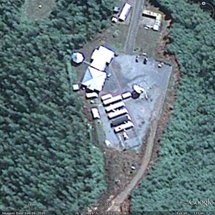
7 Example Core Site NASA Goddard Space Flight Center, Greenbelt MD, USA Goddard Geophysical and Astronomical Observatory (GGAO) has four techniques on site Legacy SLR, VLBI, GPS, DORIS NGSLR semi - operational VLBI2010 systems in testing GGAO will be the location for the prototype next generation multi-technique station

8 Concepcion, Chile VLBI SLR


9 New Co-located Sites in Russia Badary Zelenchukskaya
10 Techniques are all Making Progress Satellite Laser Ranging Many systems working in the Khz regime; Single photon detection; Increased data yield and daylight ranging on the GNSS satellites; Several new systems in Russia; Progress on the GPS-3 arrays; VLBI Prototype VLBI 2010 in testing at GSFC and Wettzell; New Systems Systems Tasmania, Katherine, Yarragadee Stations; Wettzell twin telescopes; GNSS Multiple constellations Additional frequencies New ground stations DORIS Nearly complete network already Additional satellites New beacons
11 SLR+VLBI Networks (with SLR/VLBI Co-locations noted) Current Situation: Too few co-location sites; Inadequate geographic coverage; Not all sites are well positioned geographically; Some sites have poor local conditions; Some sites are inadequately funded; Mix of new and legacy technologies and procedures


12 Core Site Ground Co-location Ground Survey and the essential role of the intersystem vector VLBI DORIS PROBLEM Reference Points are either not accessible or not well defined; Complex procedures and modeling required to estimate the reference points; Ground survey infrequently performed; Limited accuracy SLR GPS 11

")


13 Co-location in Space (Complimentary to Ground Survey) Compass GNSS/SLR GLONASS GNSS/SLR GPS GNSS/SLR GIOVE/Galileo GNSS/SLR Jason DORIS/GNSS/SLR CHAMP GNSS/SLR Envisat DORIS/SLR GRACE GNSS/SLR PROBLEM: Limited technique combinations and inadequate spacecraft calibrations 12

14 GRASP Geodetic Reference Antenna in Space Co-location of geodetic techniques contributing to the TRF. GPS receiver Determine TRF with 1 mm accuracy and 0.1 mm/yr stability. Orbit: H = km polar, sun-synchronous. SLR retroreflector DORIS receiver VLBI beacon Sept Unified Analysis Workshop Zürich 13


15 GGOS Site Requirements Document ( Introduction and Justification What is a Fundamental Station? Why do we need the Reference Frame? Why do we need a global network? What is the current situation? What do we need? Site Conditions Global consideration for the location Geology Site area Weather and sky conditions Radio frequency and optical Interference Horizon conditions Air traffic and aircraft Protection Communications Land ownership Local ground geodetic networks Site Accessibility Local infrastructure and accmmodations Electric power Site security and safety Local commitment
16 GGOS Call for Participation; The Global Geodetic Core Network: Foundation for Monitoring the Earth System (Issued 15 August 2011; due 15 November 2011) We seek proposals from organizations that would participate in the development, implementation and maintenance of the GGOS Global Geodetic Core Network. To implement and operate core space geodesy stations including: existing stations that already have the four techniques implemented and plan for upgrade to the next generation systems; existing stations that have one or more techniques operational, are planning for upgrade to the next generation systems and for the implementation of the remaining techniques; To support the network design and planning activity with analysis, simulations, site research (geology, weather, logistics, personnel, etc). To help design and develop the inter-technique vector systems and operational procedures. To provide applicable space geodetic instruments for implementation at a GGOS Global Geodetic Core Site in cooperation with a local organization. To implement and operate core stations offered by others; Call for Participation has been issued through the Services and the IAG. The Call is available on the NEWS page at:
17 Summary Requirements Document CfP issued Working with the GIAC to make contacts Meeting with groups to explore and convince GEO sub-task established Bureau meets at AGU and EGU; everyone is welcome
18 Session on Co-location on Ground and in Space September 16, 2011 Session: 11:00 12:15 Pearlman M., Schuh, H.,Pavlis E.: Position paper / introduction (15 ) Bar-Sever Y.: GRASP mission status and insights (10 ) Thaller D.: GNSS/SLR combination with co-location on satellites (10 ) Springer T.: Multi-technique analysis at ESOC, recent developments (10 ) Haas R.: Observation of GLONASS satellites with VLBI (10 ) Schuh H., Plank L., Schönberger C., Böhm J.: VLBI for Space Applications (10 ) Session: 13:45 14:30 Appleby G.: SLR target signature model improvements, SLR and co-locations with gravity measurements (10 ) Ma C.: NASA Space Geodesy Program at GGAO (10 ) Schreiber U.: The next generation timing system at the Geodetic Observatory Wettzell (goals and prospects) (10 ) Nothnagel A.: New options with twin telescopes in VLBI (10 )
Satellite Laser Retroreflectors for GNSS Satellites: ILRS Standard
 Satellite Laser Retroreflectors for GNSS Satellites: ILRS Standard Michael Pearlman Director Central Bureau International Laser Ranging Service Harvard-Smithsonian Center for Astrophysics Cambridge MA
Current State and Future Developments of the IVS and Geodetic VLBI. H. Schuh, D. Behrend, A. Niell, B. Petrachenko, and R.
 Current State and Future Developments of the IVS and Geodetic VLBI H. Schuh, D. Behrend, A. Niell, B. Petrachenko, and R. Heinkelmann Bologna, 26-Sept-2008 Geodetic VLBI Unique technique for CRF Precession/Nutation
The Geodetic Reference Antenna in Space (GRASP): A Mission to Enhance the Terrestrial Reference Frame
: A Mission to Enhance the Terrestrial Reference Frame") The Geodetic Reference Antenna in Space (GRASP): A Mission to Enhance the Terrestrial Reference Frame Yoaz Bar-Sever, R. Steven Nerem, and the GRASP Team The Most Complete Geodesy Mission Collocate all
The Geodetic Reference Antenna in Space (GRASP): A Mission to Enhance the Terrestrial Reference Frame Yoaz Bar-Sever, R. Steven Nerem, and the GRASP Team The Most Complete Geodesy Mission Collocate all
Atelier GRASP 23 octobre 2014 Salle de l Espace CNES/Paris
 Atelier GRASP 23 octobre 2014 Salle de l Espace CNES/Paris 10h00 - introduction au projet de mission GRASP (R. Biancale) 10h15 - contexte programmatique CNES (P. Ultré-Guérard) 10h30 -proposition d'instrumentation
Other Space Geodetic Techniques. E. Calais Purdue University - EAS Department Civil 3273
 Other Space Geodetic Techniques E. Calais Purdue University - EAS Department Civil 3273 ecalais@purdue.edu Satellite Laser Ranging = SLR Measurement of distance (=range) between a ground station and a
Other Space Geodetic Techniques. E. Calais Purdue University - EAS Department Civil 3273
 Other Space Geodetic Techniques E. Calais Purdue University - EAS Department Civil 3273 ecalais@purdue.edu Satellite Laser Ranging Measurement of distance (=range) between a ground station and a satellite
NASA MOBLAS 4. Goddard Space Flight Center Greenbelt, MD
 Annual HPWREN Users Meeting NASA MOBLAS 4 Goddard Space Flight Center Greenbelt, MD November 19, 2008 Howard Donovan Engineering and Operations Manager Ron Sebeny MOBLAS 4 Acting Station Manager NASA Satellite
CO-LOCATION: GUIDING PRINCIPLE OF THE DORIS DEPLOYMENT
 CO-LOCATION: GUIDING PRINCIPLE OF THE DORIS DEPLOYMENT IDS WORKSHOP 2016 Jérôme Saunier 1, Zuheir Altamimi 1, Xavier Collilieux 1, Bruno Garayt 1, Médéric Gravelle 2, Jean-Claude Poyard 1 1 IGN France
IAG School on Reference Systems June 7 June 12, 2010 Aegean University, Department of Geography Mytilene, Lesvos Island, Greece SCHOOL PROGRAM
 IAG School on Reference Systems June 7 June 12, 2010 Aegean University, Department of Geography Mytilene, Lesvos Island, Greece SCHOOL PROGRAM Monday June 7 8:00-9:00 Registration 9:00-10:00 Opening Session
The Promise and Challenges of Accurate Low Latency GNSS for Environmental Monitoring and Response
 Technical Seminar Reference Frame in Practice, The Promise and Challenges of Accurate Low Latency GNSS for Environmental Monitoring and Response John LaBrecque Geohazards Focus Area Global Geodetic Observing
Geodetic Reference Frame Theory
 Technical Seminar Reference Frame in Practice, Geodetic Reference Frame Theory and the practical benefits of data sharing Geoffrey Blewitt University of Nevada, Reno, USA http://geodesy.unr.edu Sponsors:
National Reference Systems of the RUSSIAN FEDERATION, used in GLONASS. including the user and fundamental segments
 National Reference Systems of the RUSSIAN FEDERATION, used in GLONASS. including the user and fundamental segments 8-th Meeting of the International Committee on Global Navigation Satellite Systems Dubai,
Observing the APOD satellite with the AuScope VLBI network
 10 th IVS General Meeting, June 3-8, 2018, Svalbard, Norway Observing the APOD satellite with the AuScope VLBI network Andreas Hellerschmied Johannes Böhm Technische Universität Wien, Austria Lucia McCallum
GPS and GNSS from the International Geosciences Perspective
 GPS and GNSS from the International Geosciences Perspective G. Beutler Astronomical Institute, University of Bern Member of IAG Executive Committee and of IGS Governing Board National Space-Based Positioning,
Update on the International Terrestrial Reference Frame (ITRF)
") Update on the International Terrestrial Reference Frame (ITRF) Zuheir Altamimi Head of the IERS ITRF Product Center Institut National de l Information Géographique et Forestière IGN, France E-mail: zuheir.altamimi@ign.fr
Update on the International Terrestrial Reference Frame (ITRF) Zuheir Altamimi Head of the IERS ITRF Product Center Institut National de l Information Géographique et Forestière IGN, France E-mail: zuheir.altamimi@ign.fr
Multi-technique combination at observation level with NAPEOS
 Multi-technique combination at observation level with NAPEOS Michiel Otten, Claudia Flohrer, Tim Springer, Werner Enderle EGU General Assembly 2012 Vienna Austria 27/04/2012 Introduction Combination of
The International GNSS Service (IGS): Product and Services
: Product and Services") The International GNSS Service (IGS): Product and Services Ruth E. Neilan 1, Chris Rizos 2 1 Director, IGS Central Bureau, NASA/JPL, Pasadena, USA 2 VP IAG, IGS Governing Board, UNSW, Sydney, Australia
The International GNSS Service (IGS): Product and Services Ruth E. Neilan 1, Chris Rizos 2 1 Director, IGS Central Bureau, NASA/JPL, Pasadena, USA 2 VP IAG, IGS Governing Board, UNSW, Sydney, Australia
About compliance of GLONASS S/C retroreflectors system with the requirements of International Laser Ranging Service standard
 FEDERAL SPACE AGENCY FGUP «Science-Research Institute for Precise Instrument Engineering» About compliance of GLONASS S/C retroreflectors system with the requirements of International Laser Ranging Service
Scheduling VLBI satellite observations with VieVS. Andreas Hellerschmied
 Scheduling VLBI satellite observations with VieVS Andreas Hellerschmied VLBI satellite observations Motivation for VLBI satellite observations Establish inter-technique ties in space Improve ITRF realization
VLBI and DDOR activities at ESOC
 VLBI and DDOR activities at ESOC Claudia Flohrer 1, Mattia Mercolino 2, Erik Schönemann 1, Tim Springer 1, Joachim Feltens 1, René Zandbergen 1, Werner Enderle 1, Trevor Morley 3 1) Navigation Support
Evaluation of Potential Systematic Bias in GNSS Orbital Solutions
 Evaluation of Potential Systematic Bias in GNSS Orbital Solutions Graham M. Appleby Space Geodesy Facility, Natural Environment Research Council Monks Wood, Abbots Ripton, Huntingdon PE28 2LE, UK Toshimichi
(The basics of) VLBI Basics. Pedro Elosegui MIT Haystack Observatory. With big thanks to many of you, here and out there
 VLBI Basics. Pedro Elosegui MIT Haystack Observatory. With big thanks to many of you, here and out there") (The basics of) VLBI Basics Pedro Elosegui MIT Haystack Observatory With big thanks to many of you, here and out there Some of the Points Will Cover Today Geodetic radio telescopes VLBI vs GPS concept
(The basics of) VLBI Basics Pedro Elosegui MIT Haystack Observatory With big thanks to many of you, here and out there Some of the Points Will Cover Today Geodetic radio telescopes VLBI vs GPS concept
ILRS Report. Mike Pearlman Carey Noll NASA GSFC. GGOS Bureau for Networks and Observations Vienna, Austria April 20, 2016
 ILRS Report Mike Pearlman Carey Noll NASA GSFC GGOS Bureau for Networks and Observations Vienna, Austria April 20, 2016 ILRS Ground Segment (2015) New initiatives: Russia, NASA SGP, ISRO, Ny Alesund, Wettzell,
DORIS NETWORK STATUS REPORT
 DORIS NETWORK STATUS REPORT IDS Workshop, Ponta Delgada, Azores 24 September 2018 Jérôme Saunier, IGN - France IGN 1 THE NETWORK SERVING THE SPACE ALTIMETRY MISSIONS FOR MORE THAN 25 YEARS Overall performance
DGFI reference frame solution as contribution to ITRF2008
 COST Action: ES0701, Vienna, Austria, November 16-17, 2010 WG2: Velocity determination / reference frame realization DGFI reference frame solution as contribution to ITRF2008 D. Angermann, M. Seitz, H.
Space Situational Awareness 2015: GPS Applications in Space
 Space Situational Awareness 2015: GPS Applications in Space James J. Miller, Deputy Director Policy & Strategic Communications Division May 13, 2015 GPS Extends the Reach of NASA Networks to Enable New
LASER GLONASS. Dr. Shargorodskiy Victor, dr. Kosenko Victor, dr. Chubykin Alexey, dr. Pasynkov Vladimir, dr. Sadovnikov Mikhail
 Dr. Shargorodskiy Victor, dr. Kosenko Victor, dr. Chubykin Alexey, dr. Pasynkov Vladimir, dr. Sadovnikov Mikhail Open Joint-stock Company «Research-and-Production Corporation «Precision Systems and Instruments»
Session 1.2 Regional and National Reference Systems. Asia Pacific. Dr John Dawson Leader - National Geodesy Program Geoscience Australia
 Session 1.2 Regional and National Reference Systems Asia Pacific Dr John Dawson Leader - National Geodesy Program Geoscience Australia Presentation Overview Part 1 Australia s contributions to the ITRF
Strengths and weaknesses of the IGS contribution to the ITRF. Zuheir Altamimi, Xavier Collilieux, Laurent Metivier, Paul Rebischung IGN, France
 Strengths and weaknesses of the IGS contribution to the ITRF Zuheir Altamimi, Xavier Collilieux, Laurent Metivier, Paul Rebischung IGN, France 1 Outline Summary of GNSS strengths & weaknesses Extended
GNSS: orbits, signals, and methods
 Part I GNSS: orbits, signals, and methods 1 GNSS ground and space segments Global Navigation Satellite Systems (GNSS) at the time of writing comprise four systems, two of which are fully operational and
Space geodetic techniques for remote sensing the ionosphere
 Space geodetic techniques for remote sensing the ionosphere Harald Schuh 1,2, Mahdi Alizadeh 1, Jens Wickert 2, Christina Arras 2 1. Institute of Geodesy and Geoinformation Science, Technische Universität
IVS Report 2016/17. Dirk Behrend & Chopo Ma. GGOS Bureau of N&O, Vienna, Austria April 26, 2017
 IVS Report 2016/17 Dirk Behrend & Chopo Ma GGOS Bureau of N&O, Vienna, Austria April 26, 2017 Directing Board Lead: Chair: Axel Nothnagel, Univ Bonn [1 st term ends in May 17] Director CC: Dirk Behrend,
Can we improve LAGEOS solutions by combining with LEO satellites?
 Can we improve LAGEOS solutions by combining with LEO satellites? Krzysztof Sośnica, Daniela Thaller, Adrian Jäggi, Rolf Dach, Christian Baumann, Gerhard Beutler Astronomical Institute, University of Bern,
2015 Nepal Earthquakes moved the DORIS station on Everest by a few centimeters
 2015 Nepal Earthquakes moved the DORIS station on Everest by a few centimeters Guilhem Moreaux (CLS) On 25 April, 2015, an earthquake with a magnitude of 7.8 on the Richter scale struck central Nepal approximately
Processing 20 years of SLR observations to GNSS satellites
 Processing 20 years of SLR observations to GNSS satellites K. Sośnica (1, 2), R. Dach (1), D. Thaller (3), A. Jäggi (1), G. Beutler (1), D. Arnold (1) (1) Astronomical Institute, University of Bern, Sidlerstrasse
Projetd antennevlbi à Tahiti
 Projetd antennevlbi à Tahiti Richard Biancale CNES/GRGS Atelier VLBI-GRGS, 13-15 mars 2017 Université de Bordeaux Observatoire Aquitain des Sciences de l Univers OGT The present OGT site is integrated
MEOSAR & GPS ICG WG-B Vienna Austria, June 2016
 MEOSAR & GPS ICG WG-B Vienna Austria, June 2016 Dr. Lisa Mazzuca, Mission Manager NASA Search and Rescue Office Goddard Space Flight Center 1 Overview Cospas-Sarsat System GNSS-enabled Medium Earth Orbit
Orbit Determination for CE5T Based upon GPS Data
 Orbit Determination for CE5T Based upon GPS Data Cao Jianfeng (1), Tang Geshi (2), Hu Songjie (3), ZhangYu (4), and Liu Lei (5) (1) Beijing Aerospace Control Center, 26 Beiqing Road, Haidian Disrtrict,
Recent achievements in photon counting laser time transfer
 Recent achievements in photon counting laser time transfer I. Prochazka 1, J. Kodet 1,2, J. Blazej 1 Presented at ACES Workshop Fundamental and applied science with clocks and cold atoms in space University
The International Scene: How Precise Positioning Will Underpin Critical GNSS Applications
 The International Scene: How Precise Positioning Will Underpin Critical GNSS Applications School of Civil & Environmental Engineering, UNSW, Sydney, Australia Chris Rizos Member of the IGS Governing Board
GPS for crustal deformation studies. May 7, 2009
 GPS for crustal deformation studies May 7, 2009 High precision GPS for Geodesy Use precise orbit products (e.g., IGS or JPL) Use specialized modeling software GAMIT/GLOBK GIPSY OASIS BERNESE These software
Current Earth Orientation Parameters and Global combinations
 Current Earth Orientation Parameters and Global combinations D. Gambis C. Bizouard O. Becker, J.Y. Richard, T. Carlucci Earth Orientation Center of the IERS Observatoire de Paris +Colleagues of GRGS Main
Global GPS-VLBI Hybrid Observation. Younghee Kwak
 Global GPS-VLBI Hybrid Observation Younghee Kwak Classical VLBI vs. Space Craft Tracking plane wave front stable sources curved wave front fast moving sources Plank(2013) 2/20 Space craft tracking by VieVS2tie
Contributions of Onsala Space Observatory to GGOS
 Contributions of Onsala Space Observatory to GGOS R. Haas, G. Elgered, T. Hobiger, H.-G. Scherneck, J. Johansson Abstract The Onsala Space Observatory (OSO) on the Swedish west coast is the fundamental
Consistency of parameters derived from global SLR, VLBI and GNSS solutions when using non-tidal loading deformation on the observation level
 Consistency of parameters derived from global SLR, VLBI and GNSS solutions when using non-tidal loading deformation on the observation level Ole Roggenbuck (1), D. Thaller (1), G. Engelhardt (1), R. Dach
GPS Geodetic Reference System WGS 84
 GPS Geodetic Reference System WGS 84 International Committee on GNSS Working Group D Saint Petersburg, Russia 16 September 2009 Barbara Wiley National Geospatial-Intelligence Agency United States of America
SLR residuals to GPS / GLONASS and combined GNSS-SLR analysis
 SLR residuals to GPS / GLONASS and combined GNSS-SLR analysis D. Thaller, K. Sośnica, R. Dach, A. Jäggi, C. Baumann Astronomical Institute, University of Bern, Switzerland International Technical Laser
TECHNOLOGICAL DEVELOPMENTS AT IGN INSTRUMENTATION AND TECHNOLOGICAL DEVELOPMENTS AT THE IGN
 INSTRUMENTATION AND TECHNOLOGICAL DEVELOPMENTS AT THE IGN Yebes Observatory is a Fundamental Geodetic Station where Astronomical, Geodetic and Geophysical techniques are combined. Yebes, Guadalajara, Spain
Integrated geodetic infrastructure at the Geodetic Observatory Pecný, Czech Republic, in service of national and international GNSS projects
 Integrated geodetic infrastructure at the Geodetic Observatory Pecný, Czech Republic, in service of national and international GNSS projects Pavel NOVÁK, Czech Republic Key words: geodesy, reference systems,
VLBI processing at ESOC
 VLBI processing at ESOC Claudia Flohrer, Erik Schönemann, Tim Springer, René Zandbergen, Werner Enderle ESOC - Navigation Support Office (OPS-GN), Darmstadt, Germany 9th IVS General Meeting Johannesburg
Applications, Products and Services of GPS Technology
 Applications, Products and Services of GPS Technology Enrico C. Paringit. Dr. Eng. University of the Philippines Training Center for Applied Geodesy and Photogrammetry 1 Outline of this Presentation GPS
IGS workshop 2018 Multi-GNSS through Global Collaboration Datum: 29 October - 2 November 2018 Plats: Wuhan, China Deltagare: Tong Ning (I0101)
") 2018-11-19 RESERAPPORT IGS workshop 2018 Multi-GNSS through Global Collaboration Datum: 29 October - 2 November 2018 Plats: Wuhan, China Deltagare: Tong Ning (I0101) Syfte med mötet The workshop programme
2018-11-19 RESERAPPORT IGS workshop 2018 Multi-GNSS through Global Collaboration Datum: 29 October - 2 November 2018 Plats: Wuhan, China Deltagare: Tong Ning (I0101) Syfte med mötet The workshop programme
VLBI2010: In search of Sub-mm Accuracy
 VLBI2010: In search of Sub-mm Accuracy Bill Petrachenko, Nov 6, 2007, University of New Brunswick What is VLBI2010? VLBI2010 is an effort by the International VLBI Service for Geodesy and Astrometry (IVS)
Reference Systems: Definition and Realization Associated IAG Services IAG Reference Frame Sub-commission for Europe (EUREF)
") Reference Systems: Definition and Realization Associated IAG Services IAG Reference Frame Sub-commission for Europe (EUREF) Zuheir ALTAMIMI Laboratoire de Recherche en Géodésie Institut Géographique National
Reference Systems: Definition and Realization Associated IAG Services IAG Reference Frame Sub-commission for Europe (EUREF) Zuheir ALTAMIMI Laboratoire de Recherche en Géodésie Institut Géographique National
Terrestrial reference frame solution with the Vienna VLBI Software VieVS and implication of tropospheric gradient estimation
 Terrestrial reference frame solution with the Vienna VLBI Software VieVS and implication of tropospheric gradient estimation H. Spicakova, L. Plank, T. Nilsson, J. Böhm, H. Schuh Abstract The Vienna VLBI
The realization of a 3D Reference System
 The realization of a 3D Reference System Standard techniques: topographic surveying and GNSS Observe angles and distances either between points on the Earth surface or to satellites and stars. Do not observe
System Status and Performance Improvement Prospects
 Communication Геодезия Navigation GLOBAL NAVIGATION SATELLITE SYSTEM (GLONASS): System Status and Performance Improvement Prospects Viktor KOSENKO, First Deputy General Designer First Deputy General Director
International Committee on Global Navigation Satellite Systems (ICG)
") International Committee on Global Navigation Satellite Systems (ICG) A forum to discuss global navigation satellite systems to benefit people around the world Sharafat Gadimova United Nations Office for
International Committee on Global Navigation Satellite Systems (ICG) A forum to discuss global navigation satellite systems to benefit people around the world Sharafat Gadimova United Nations Office for
Autonomous and Autonomic Systems: With Applications to NASA Intelligent Spacecraft Operations and Exploration Systems
 Walt Truszkowski, Harold L. Hallock, Christopher Rouff, Jay Karlin, James Rash, Mike Hinchey, and Roy Sterritt Autonomous and Autonomic Systems: With Applications to NASA Intelligent Spacecraft Operations
Korea Astronomy and Space Science Institute 2. National Institute of Information and Communications Technology 3. Ajou University 4.
 Kwak, Younghee 1 Tetsuro Kondo 2, Tadahiro Gotoh 2, Jun Amagai 2, Hiroshi Takiguchi 2, Mamoru Sekido 2, Ryuichi Ichikawa 2, Tetsuo Sasao 4, Junghe Cho 1, Tuhwan Kim 3 1 Korea Astronomy and Space Science
Services of the International Association of Geodesy and IGS - Global Geodetic Observing System Links & References
 Services of the International Association of Geodesy and IGS - Global Geodetic Observing System Links & References Ruth E. Neilan Director, IGS Central Bureau; Vice-Chair, GGOS www.igs.org www.ggos.org
BeiDou Space Service Volume Parameters and its Performance
 BeiDou Space Service Volume Parameters and its Performance Prof. Xingqun ZHAN, Shuai JING Shanghai Jiaotong University, China Xiaoliang WANG China Academy of Space Technology Contents 1 Background and
Very Long Baseline Interferometry (VLBI) Lecture I. H. Schuh, L. Plank
 Lecture I. H. Schuh, L. Plank") Very Long Baseline Interferometry (VLBI) Lecture I H. Schuh, L. Plank 1 1. Introduction: Very Long Baseline Interferometry 1933 (Karl Jansky): 1st measurement of radio signals Fast development after WW2
Very Long Baseline Interferometry (VLBI) Lecture I H. Schuh, L. Plank 1 1. Introduction: Very Long Baseline Interferometry 1933 (Karl Jansky): 1st measurement of radio signals Fast development after WW2
Understanding GPS/GNSS
 Understanding GPS/GNSS Principles and Applications Third Edition Contents Preface to the Third Edition Third Edition Acknowledgments xix xxi CHAPTER 1 Introduction 1 1.1 Introduction 1 1.2 GNSS Overview
EUREF Permanent GNSS Network Carine Royal Observatory of Belgium
 ENEON first workshop Observing Europe: Networking the Earth Observation Networks in Europe EUREF Permanent GNSS Network Carine Bruyninx/C.Bruyninx@oma.be Royal Observatory of Belgium 1. About your network
Impact of GLONASS in a rigorous combination with GPS
 Fakultät Umweltwissenschaften Professur für Geodätische Erdsystemforschung source: https://doi.org/10.7892/boris.44677 downloaded: 13.3.2017 Session 1.2a Strength, Weakness, Modeling Standards and Processing
International Committee on Global Navigation Satellite Systems
 International Committee on Global Navigation Satellite Systems Training Course on Global Navigation Satellite Systems 14 18 January 2019, Asian Institute of Technology, Bangkok, Thailand Sharafat Gadimova
Keeping the universe connected. Enabling a Fully Interoperable GNSS Space Service Volume
 Keeping the universe connected. Enabling a Fully Interoperable GNSS Space Service Volume James J. Miller, Deputy Director, Policy and Strategic Communications, NASA Michael C. Moreau, Ph.D., Navigation
Community Perspective: GeoSpace Observations and Analysis
 Community Perspective: GeoSpace Observations and Analysis Prof. Jeff Thayer Aerospace Engineering Sciences Department OBSERVATION AND ANALYSIS OPPORTUNITIES COLLABORATING WITH THE ICON AND GOLD MISSIONS,
SIRGAS: the geodetic reference frame for Latin America and the Caribbean
 SIRGAS: the geodetic reference frame for Latin America and the Caribbean C. Brunini UNLP, Argentina L. Sánchez DGFI, Germany V. Mackern UNCuyo, UJAM, Argentina W. Martínez IGAC, Colombia R. Luz IBGE, Brazil
Real-Time and Multi-GNSS Key Projects of the International GNSS Service
 Real-Time and Multi-GNSS Key Projects of the International GNSS Service Urs Hugentobler, Chris Rizos, Mark Caissy, Georg Weber, Oliver Montenbruck, Ruth Neilan EUREF 2013 Symposium Budapest, Hungary, May
A CubeSat-Based Optical Communication Network for Low Earth Orbit
 A CubeSat-Based Optical Communication Network for Low Earth Orbit Richard Welle, Alexander Utter, Todd Rose, Jerry Fuller, Kristin Gates, Benjamin Oakes, and Siegfried Janson The Aerospace Corporation
SSC space expertise on the ground
 SSC space expertise on the ground FMV Sensor Symposium Stockholm, September 2016 Björn Ohlson and Petrus Hyvönen Satellite Services for Surveillance & Reconnaissance Navigation Communication and Space
GFZ Potsdam contributions to ELT
 Aces workshop, Zürich, Switzerland, 29th 30th June 2017. GFZ Potsdam contributions to ELT S. Bauer 1, L. Grunwaldt 1, E.D. Hoffman 2 1 GFZ Potsdam, Brandenburg, Germany. 2 NASA GSFC, Greenbelt, Maryland,
EVGA Meeting March 7 th 2013
 Interface Current release and plans for the future Johannes Böhm Sigrid Böhm Hana Krásná Tobias Nilsson Lucia Plank Claudia Tierno Ros Harald Schuh Benedikt Soja Jing Sun Kamil Teke EVGA Meeting March
NASA Search and Rescue Cospas-Sarsat MEOSAR, Second Generation Beacons, and DF Receiver with UAS March 23, 2017
 NASA Search and Rescue Cospas-Sarsat MEOSAR, Second Generation Beacons, and DF Receiver with UAS March 23, 2017 Dr. Lisa Mazzuca Mission Manager NASA Search and Rescue Office Goddard Space Flight Center
Surveying in the Year 2020
 Surveying in the Year 2020 Johannes Schwarz Leica Geosystems My first toys 2 1 3 Questions Why is a company like Leica Geosystems constantly developing new surveying products and instruments? What surveying
Precise Positioning GNSS Applications
 Precise Point Positioning: Is the Era of Differential GNSS Positioning Drawing to an End? School of Surveying & Spatial Information Systems, UNSW, Sydney, Australia Chris Rizos 1, Volker Janssen 2, Craig
Status and future plans for the Vienna VLBI Software VieVS
 Status and future plans for the Vienna VLBI Software Johannes Böhm Sigrid Böhm Matthias Madzak Vahab Nafisi Lucia Plank Hana Spicakova Jing Sun Claudia Tierno Ros Harald Schuh Institute of Geodesy and
ICG-12 Kyoto Japan WG-B December Dr. Lisa Mazzuca
 ICG-12 Kyoto Japan WG-B December 5 2017 Dr. Lisa Mazzuca MEOSAR: SPACE SEGMENT BDS & Cospas-Sarsat: C-S JC-31 (Oct 2017) China Working Papers BDS 406 MHz MEOSAR REPEATER TECHNOLOGY STATUS (JC31-9/2) Executive
Experiences with Fugro's Real Time GPS/GLONASS Orbit/Clock Decimeter Level Precise Positioning System
 Return to Session Directory DYNAMIC POSITIONING CONFERENCE October 13-14, 2009 Sensors Experiences with Fugro's Real Time GPS/GLONASS Orbit/Clock Decimeter Level Precise Positioning System Ole Ørpen and
SPACE-BASED SOLUTIONS & ANALYTICS
 SPACE-BASED SOLUTIONS & ANALYTICS Enable development and optimisation of airspace use, and no aircraft to be lost again wherever on Earth C N S S y m p o s i u m E u r o c o n t r o l 2 & 3 O c t o b e
Implementation of New Positioning System in Riga
 Implementation of New Positioning System in Riga M.Abele (1), J.Balodis (1), K.Balodis (1), M.Caunite (1), I.Janpaule (1), A.Rubans (1), G.Silabriedis (1,2), I.Mitrofanovs(2), A.arinsjh (1) (1) University
IDS REPORT IERS Directing Board Meeting Vienna, AUSTRIA April 8, 2018
 IDS REPORT 2018 IERS Directing Board Meeting Vienna, AUSTRIA April 8, 2018 IDS IERS members: Hugues Capdeville (CLS) Jean-Michel Lemoine (CNES) Jérôme Saunier (IGN) Guilhem Moreaux (CLS) Pascale Ferrage
Galileo signal reflections used for monitoring waves and weather at sea
 Press Release Monday 26 th November 2007 Galileo signal reflections used for monitoring waves and weather at sea Surrey Satellite Technology Ltd (SSTL) and the University of Surrey have succeeded for the
Introduction to ILWS. George Withbroe. Office of Space Science Sun Earth Connection Division NASA Headquarters
 Introduction to ILWS George Withbroe Office of Space Science Sun Earth Connection Division NASA Headquarters GOAL: Stimulate and strengthen research in solar-terrestrial physics to improve understanding
NGSLR's measurement of the retro-reflector array response of various LEO to GNSS satellites
 NGSLR's measurement of the retro-reflector array response of various LEO to GNSS satellites Jan McGarry Christopher Clarke, John Degnan, Howard Donovan, Benjamin Han, Julie Horvath, Thomas Zagwodzki NASA/GSFC
Brazil and Russia space cooperation: recent projects and future perspectives in the field of GNSS monitoring and SLR stations
 Brazil and Russia space cooperation: recent projects and future perspectives in the field of GNSS monitoring and SLR stations Renato A. Borges (UnB) and Geovany A. Borges (UnB) Emails: raborges@ene.unb.br
Dimov Stojče Ilčev. CNS Systems
 Stratospheric Platform Systems (SPS) Presentation by: Dimov Stojče Ilčev Durban University of Technology (DUT) Space Science Centre (SSC) CNS Systems August 2011 SPS for Mobile CNS Applications Stratospheric
GPS/WAAS Program Update
 GPS/WAAS Program Update UN/Argentina Workshop on the Applications of GNSS 19-23 March 2018 Cordoba, Argentina GNSS: A Global Navigation Satellite System of Systems Global Constellations GPS (24+3) GLONASS
S a t e l l i t e T i m e a n d L o c a t i o n. N o v e m b e r John Fischer VP Advanced R&D
 STL - S a t e l l i t e T i m e a n d L o c a t i o n N o v e m b e r 2 0 1 7 John Fischer VP Advanced R&D jfischer@orolia.com 11/28/201 1 7 WHY AUGMENT GNSS? Recent UK Study Economic Input to UK of a
Nigerian Communications Satellite Ltd. (NIGCOMSAT)
") OVERVIEW OF NIGERIAN SATELLITE AUGMENTATION SYSTEM COMMENCING WITH PILOT DEMONSTRATION TO VALIDATE NATIONAL WORK PLAN presented by Dr. Lawal Lasisi Salami, NIGERIAN COMMUNICATIONS SATELLITE LTD UNDER FEDERAL
OVERVIEW OF NIGERIAN SATELLITE AUGMENTATION SYSTEM COMMENCING WITH PILOT DEMONSTRATION TO VALIDATE NATIONAL WORK PLAN presented by Dr. Lawal Lasisi Salami, NIGERIAN COMMUNICATIONS SATELLITE LTD UNDER FEDERAL
Apport du VLBI à l ITRF: forces et faiblesses
 Apport du VLBI à l ITRF: forces et faiblesses Zuheir Altamimi Paul Rebischung Laurent Métivier Xavier Collilieux IGN, France Email: zuheir.altamimi@ign.fr Présenté par David Coulot Introduction: Points-clé
SIRGAS: BASIS FOR GEOSCIENCES, GEODATA, AND NAVIGATION IN LATIN AMERICA
 SIRGAS: BASIS FOR GEOSCIENCES, GEODATA, AND NAVIGATION IN LATIN AMERICA Laura Sánchez SIRGAS Vice-president Deutsches Geodätisches Forschungsintitut Munich, Germany Claudio Brunini SIRGAS President Universidad
Chapter 2 Modernization of GNSS
 Chapter 2 Modernization of GNSS With four Global Navigation Satellite Systems fully operational by the end of the decade, users on Earth can enjoy signals, at multiple frequencies in the L-band of the
ASSEMBLY 37TH SESSION
 International Civil Aviation Organization WORKING PAPER A37-WP/195 1 22/9/10 (Information paper) ASSEMBLY 37TH SESSION TECHNICAL COMMISSION Agenda Item 35: The Global Air Traffic Management (ATM) System
Views on Interoperability
 Views on Interoperability International Committee on Global Navigation Satellite Systems Prague, November 10 th 14 th 2014 Navigation solutions powered by Europe INTRODUCTION The original purpose of the
FieldGenius Technical Notes GPS Terminology
 FieldGenius Technical Notes GPS Terminology Almanac A set of Keplerian orbital parameters which allow the satellite positions to be predicted into the future. Ambiguity An integer value of the number of
Worst-Case GPS Constellation for Testing Navigation at Geosynchronous Orbit for GOES-R
 Worst-Case GPS Constellation for Testing Navigation at Geosynchronous Orbit for GOES-R Kristin Larson, Dave Gaylor, and Stephen Winkler Emergent Space Technologies and Lockheed Martin Space Systems 36
ICG WG-B Achievements on Interoperable GNSS Space Service Volume (SSV) November, 2016 Sochi, Russian Federation
 November, 2016 Sochi, Russian Federation") ICG WG-B Achievements on Interoperable GNSS Space Service Volume (SSV) November, 2016 Sochi, Russian Federation ICG WG-B Action Group on SSV Action group on SSV was formed within WG-B in order to Establish
ICG WG-B Achievements on Interoperable GNSS Space Service Volume (SSV) November, 2016 Sochi, Russian Federation ICG WG-B Action Group on SSV Action group on SSV was formed within WG-B in order to Establish