Introduction. Mathematical Background Preparation using ENVI.
|
|
|
- Jesse Bridges
- 5 years ago
- Views:
Transcription
1 Andrew Nordquist Investigating Automatic Registration and Mosaicking in ENVI 3 December 2007 Project Proposal for EES Remote Sensing Class Introduction. Registering two images means we want to compare data between the two in a quantitative manner. The images may be rotated, displaced or even scaled differently compared to one another, depending on the source of each image. For instance, one may want to compare Landsat data with an equivalent Hyperion image. Usually, performing a registration means manually locating many points known as ground control points (GCPs) - that are known to be the same feature between the two images. It also turns out that automatic (computer) registration of two images can be done, provided there is enough common area. It may be possible to use this same technique to mosaic multiple adjacent images together into one image. Automatic image registration of two square map portions can be done using a Fourier Transform technique. This technique is described by Xie, et al, in a paper published in the Computers and Geosciences journal in March 2003 [1]. The paper was entitled, An IDL/ENVI implementation of the FFT-based algorithm for automatic image registration. I will go over what I did in ENVI and with the IDL routines provided from the abovementioned paper. When I refer to IDL routines, I am using them verbatim from the ZIP file provided by a link at the LRSG website. I will show results from my attempts to perform automatic registration on files other than what was provided. Mathematical Background. It turns out that if you perform a fourier transform on each of two images whose difference is only a shift, there is a simple relationship between them [2]. If you take the inverse fourier transform after normalizing by their absolute values, you end up with a delta function that is located at the point in the original image space that is equal to the shift, from the origin. This multiplication of two fourier transforms is very similar to what s known as a convolution, or a correlation. This is not to be confused with the statistical covariance of two distributions. Perhaps the fourier transforms give you an analog in a two-dimensional space to the rather one-dimensional distributions of numbers. Preparation using ENVI. I explored ENVI's capability for doing what was termed Automatic Registration. I compared registration techniques with ENVI and with the IDL routine provided. One example was a simple shift in the pixels. Both methods picked up the correct amount of shift. Another example was a simple scale and rotate. Again, both methods were successful in finding the amount of shift and rotation that was introduced. By both methods, I refer to 1) the Automatic Registration capability of ENVI, plus 2) the IDL routines. ENVI s Automatic Registration feature is located under the Map menu. The automatic part involves automatically generating GCPs so that the images can 1
2 be registered in more or less the old style. I will get into the details of the ENVI procedure shortly. Another example provided was a little more interesting. It was a set of Landsat images of nearly the same place at different times. One image was shifted from the reference; another was scaled and rotated. Again both methods gave expected results. By this point in time, I have repeated the work done in the Xie paper, but did parallel work in ENVI. The trouble was, ENVI work took a lot more time than just running the IDL routines, because of having to deal with GCPs. To proceed with Automatic Registration, select Map Registration Automatic Registration: Image to Image from the ENVI menu. There are other options that allow for working more directly with GCPs. Then it s time to select base and warp images. The base image is the unaltered reference file; the warp image is the one that will be altered to register with the base image. Next, some Automatic Registration parameters are selected. There s a choice for matching method: area-based or feature-based, with different parameters for each. I ve had trouble with the area-based matching method on a more complex image. I ve gotten better GCPs with the feature-based matching method. However, with a simpler region (i.e. the shifted image provided from the paper), I got excellent GCPs from using the area-based matching method. There s an option for examining the tie points before warping the image; I think it s always a good idea to examine those points. I ve seen some poor automatic choices with the cases that I ve run. If feature-based matching is chosen, some iteration goes on automatically. The program switches between building scale space images from image pyramid and finding feature points from difference of Gaussian, going through each procedure twice. Then it matches feature points and presents you with a GCP Selection window and Image-to- Image GCP list. After examining and adjusting the points, they can be saved. I found that if I was able to reduce the error that was displayed in the GCP table to less than 1 meter, I got good results on warping. Under the Options menu of the GCP Selection window is the provision to Warp Displayed Band. Up pops a Registration Parameters window. There are choices for method between RST, Polynomial (with degree), and (Delaunay) Triangulation. There are also some Resampling choices: Nearest Neighbor, Bilinear, or Cubic Convolution. I only had a chance to use the Polynomial method, up to degree 3 (depending on the number of GCPs), and the Bilinear or Nearest Neighbor resampling. Once the choices are made, the warped image becomes available. I ve seen some very good and some very bad warped images in the time that I ve worked with the procedure. If care is taken to get good GCPs, the warped image provides an excellent match to the base image, and a mosaic can be done (see below). Once the warped image comes away from the region where the two images overlap, it can warp quite noticeably. 2

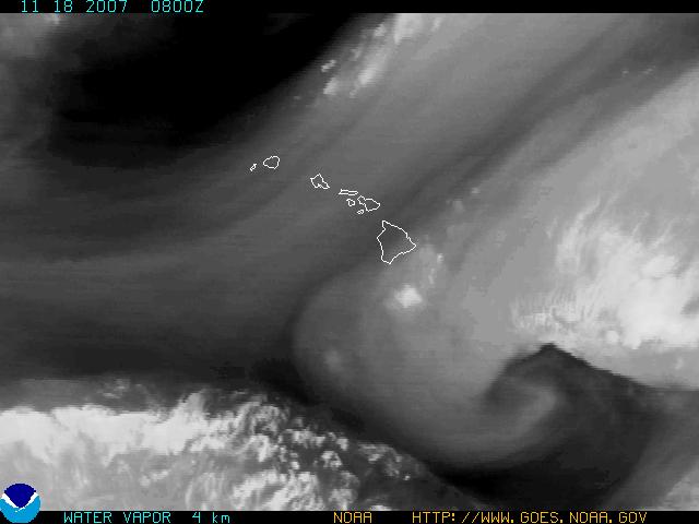
3 Sometimes I ve seen it, and sometimes I haven t. It seems to depend on many things, not the least of which is GCP selection and registration and resampling methods. The following image shows the mosaic I made from two of the images provided from the Xie Paper. There is some distortion in the warped image where it doesn t overlap with the base image; I think this is an average example with distortion that could be improved with more work on the GCPs and the registration methods. So there it is - the Automatic Registration procedure in ENVI. It s not so automatic; then again I would not want to select 25 GCPs manually. I think that would take longer. I then proceeded to find some images on the Internet that I could use the IDL routine on to find out if I could extract information from the process. I thought storm or hurricane weather patterns of the infrared or water vapor type would provide good input data. I found and downloaded GIF files from the NOAA website. They have an archive database going back up to 3 weeks on hourly weather images for the West Coast, Alaska, and Hawaii. I picked up one set of each, covering 27 hours of weather for the three areas, with four hours difference between the images. The images for Alaska are on the following page and Hawaii images are shown on the page after that. The set of Alaska images I think looks like a difficult thing to register; while the Hawaii images look like they would do a better job. 3


4 4


5 5
6 I thought a much better image to register would be a hurricane, so I was able to find GIF images of Katrina and Rita. The Katrina images are shown two pages following this one. Surely those two images would show some kind of shift or rotation! Results. I did not get any shift or rotation results from any of these images. I looked at the statistics and I think I found the problem. The histograms are pretty choppy; not all DN values are represented in these images. I had to convert the GIF files to TIF before I could read them into ENVI; and I tried JPEG, Bitmaps, PICT, and one or two other types, but the histograms remained the same. I stuck with TIF format. I always got three bands of data, with each band usually identical to the other two. The following page shows representative histograms for the data I obtained. I tried stretching the Alaska data, but the outcome did not change. I was able to bring the GIF file into ENVI with several different types of bitmaps: monochrome, 16-bit, 24-bit, and 256-bit. Each one gave me a different histogram, with more bits generally giving me more 0 s in the DN values between nonzero points. That is, there were more unused DN values the more bits worth of bitmap I tried. I think the solution rides within that clue: I think I need to read the GIF files into ENVI in a different way. Or, I need to process the GIF file in a different or special way. I m interested in pursuing this, to see if I can resolve the situation. Bibliography. [1] Xie H, Hicks N, Keller GR, Huang H, and Kreinovich V. An IDL/ENVI implementation of the FFT-based algorithm for automatic image registration. Computers and Geosciences 2003; 29: [2] Araiza R, Xie H, Starks SA, and Kreinovich V. Automatic referencing of multispectral images. Proc IEEE Southwest Symposium on Image Analysis and Interpretation 2002; pages


7 Histograms for the weather plots. Top, Alaska; middle, Hawaii; bottom, Katrina. 7


8 Katrina images from GIF files. These two images have the same scale and geographical placement, as indicated by the outline of the FL, LA, and TX coast shown in white near the top. It should be an ideal pair of images to attempt to register to each other. 8
ENVI Tutorial: Orthorectifying Aerial Photographs
 ENVI Tutorial: Orthorectifying Aerial Photographs Table of Contents OVERVIEW OF THIS TUTORIAL...2 ORTHORECTIFYING AERIAL PHOTOGRAPHS IN ENVI...2 Building the interior orientation...3 Building the exterior
Preparing Remote Sensing Data for Natural Resources Mapping (image enhancement, rectifications )
") Preparing Remote Sensing Data for Natural Resources Mapping (image enhancement, rectifications ) Why is this important What are the major approaches Examples of digital image enhancement Follow up exercises
Preparing Remote Sensing Data for Natural Resources Mapping (image enhancement, rectifications ) Why is this important What are the major approaches Examples of digital image enhancement Follow up exercises
Filters. Materials from Prof. Klaus Mueller
 Filters Materials from Prof. Klaus Mueller Think More about Pixels What exactly a pixel is in an image or on the screen? Solid square? This cannot be implemented A dot? Yes, but size matters Pixel Dots
Remote sensing image correction
 Remote sensing image correction Introductory readings remote sensing http://www.microimages.com/documentation/tutorials/introrse.pdf 1 Preprocessing Digital Image Processing of satellite images can be
CanImage. (Landsat 7 Orthoimages at the 1: Scale) Standards and Specifications Edition 1.0
 Standards and Specifications Edition 1.0") CanImage (Landsat 7 Orthoimages at the 1:50 000 Scale) Standards and Specifications Edition 1.0 Centre for Topographic Information Customer Support Group 2144 King Street West, Suite 010 Sherbrooke, QC
CanImage (Landsat 7 Orthoimages at the 1:50 000 Scale) Standards and Specifications Edition 1.0 Centre for Topographic Information Customer Support Group 2144 King Street West, Suite 010 Sherbrooke, QC
Application of GIS to Fast Track Planning and Monitoring of Development Agenda
 Application of GIS to Fast Track Planning and Monitoring of Development Agenda Radiometric, Atmospheric & Geometric Preprocessing of Optical Remote Sensing 13 17 June 2018 Outline 1. Why pre-process remotely
Basic Digital Image Processing. The Structure of Digital Images. An Overview of Image Processing. Image Restoration: Line Drop-outs
 Basic Digital Image Processing A Basic Introduction to Digital Image Processing ~~~~~~~~~~ Rev. Ronald J. Wasowski, C.S.C. Associate Professor of Environmental Science University of Portland Portland,
Image Fusion. Pan Sharpening. Pan Sharpening. Pan Sharpening: ENVI. Multi-spectral and PAN. Magsud Mehdiyev Geoinfomatics Center, AIT
 1 Image Fusion Sensor Merging Magsud Mehdiyev Geoinfomatics Center, AIT Image Fusion is a combination of two or more different images to form a new image by using certain algorithms. ( Pohl et al 1998)
GE 113 REMOTE SENSING
 GE 113 REMOTE SENSING Topic 8. Image Classification and Accuracy Assessment Lecturer: Engr. Jojene R. Santillan jrsantillan@carsu.edu.ph Division of Geodetic Engineering College of Engineering and Information
Remote Sensing Instruction Laboratory
 Laboratory Session 217513 Geographic Information System and Remote Sensing - 1 - Remote Sensing Instruction Laboratory Assist.Prof.Dr. Weerakaset Suanpaga Department of Civil Engineering, Faculty of Engineering
Satellite image classification
 Satellite image classification EG2234 Earth Observation Image Classification Exercise 29 November & 6 December 2007 Introduction to the practical This practical, which runs over two weeks, is concerned
The Airphoto Ortho Suite is an add-on to Geomatica. It requires Geomatica Core or Geomatica Prime as a pre-requisite.
 Airphoto Ortho Suite The Airphoto Ortho Suite includes rigorous models used to correct the geometry of analogue and digital/video cameras and to produce orthorectified air photos. These models compensate
GIS and Remote Sensing
 GE110 Fall 2008 Week 4 October 18, 2010 GIS and Remote Sensing Lab 2 LANDSAT 7 and ASTER In this lab, you will: 1. Process the LANDSAT 7 ETM+ image to emphasize the useful information a. Transformations
USE OF HISTOGRAM EQUALIZATION IN IMAGE PROCESSING FOR IMAGE ENHANCEMENT
 USE OF HISTOGRAM EQUALIZATION IN IMAGE PROCESSING FOR IMAGE ENHANCEMENT Sapana S. Bagade M.E,Computer Engineering, Sipna s C.O.E.T,Amravati, Amravati,India sapana.bagade@gmail.com Vijaya K. Shandilya Assistant
A Novel Method for Enhancing Satellite & Land Survey Images Using Color Filter Array Interpolation Technique (CFA)
") A Novel Method for Enhancing Satellite & Land Survey Images Using Color Filter Array Interpolation Technique (CFA) Suma Chappidi 1, Sandeep Kumar Mekapothula 2 1 PG Scholar, Department of ECE, RISE Krishna
A Novel Method for Enhancing Satellite & Land Survey Images Using Color Filter Array Interpolation Technique (CFA) Suma Chappidi 1, Sandeep Kumar Mekapothula 2 1 PG Scholar, Department of ECE, RISE Krishna
Image Scaling. This image is too big to fit on the screen. How can we reduce it? How to generate a halfsized
 Resampling Image Scaling This image is too big to fit on the screen. How can we reduce it? How to generate a halfsized version? Image sub-sampling 1/8 1/4 Throw away every other row and column to create
An Approach To Correct The Raw FCC Satellite Image
 An Approach To Correct The Raw FCC Satellite Image Satyanarayana Chanagala 1, Yedukondalu Kamatham 2, Appala Raju Uppala 3 And Najeemulla Baig 4 Dept. of ECE, ACE Engineering College, Ankushapur, Ghatkesar
[GEOMETRIC CORRECTION, ORTHORECTIFICATION AND MOSAICKING]
![[GEOMETRIC CORRECTION, ORTHORECTIFICATION AND MOSAICKING]](/thumbs/78/78211997.jpg "[GEOMETRIC CORRECTION, ORTHORECTIFICATION AND MOSAICKING]") 2013 Ogis-geoInfo Inc. IBEABUCHI NKEMAKOLAM.J [GEOMETRIC CORRECTION, ORTHORECTIFICATION AND MOSAICKING] [Type the abstract of the document here. The abstract is typically a short summary of the contents
2013 Ogis-geoInfo Inc. IBEABUCHI NKEMAKOLAM.J [GEOMETRIC CORRECTION, ORTHORECTIFICATION AND MOSAICKING] [Type the abstract of the document here. The abstract is typically a short summary of the contents
GEO/EVS 425/525 Unit 9 Aerial Photograph and Satellite Image Rectification
 GEO/EVS 425/525 Unit 9 Aerial Photograph and Satellite Image Rectification You have seen satellite imagery earlier in this course, and you have been looking at aerial photography for several years. You
IEEE TRANSACTIONS ON GEOSCIENCE AND REMOTE SENSING 1
 IEEE TRANSACTIONS ON GEOSCIENCE AND REMOTE SENSING 1 A Mixed Radiometric Normalization Method for Mosaicking of High-Resolution Satellite Imagery Yongjun Zhang, Lei Yu, Mingwei Sun, and Xinyu Zhu Abstract
Introduction to Remote Sensing Part 1
 Introduction to Remote Sensing Part 1 A Primer on Electromagnetic Radiation Digital, Multi-Spectral Imagery The 4 Resolutions Displaying Images Corrections and Enhancements Passive vs. Active Sensors Radar
GE 113 REMOTE SENSING. Topic 7. Image Enhancement
 GE 113 REMOTE SENSING Topic 7. Image Enhancement Lecturer: Engr. Jojene R. Santillan jrsantillan@carsu.edu.ph Division of Geodetic Engineering College of Engineering and Information Technology Caraga State
Remote Sensing. The following figure is grey scale display of SPOT Panchromatic without stretching.
 Remote Sensing Objectives This unit will briefly explain display of remote sensing image, geometric correction, spatial enhancement, spectral enhancement and classification of remote sensing image. At
v WMS 10.0 Tutorial Introduction Images Read images in a variety of formats and register the images to a coordinate projection
 v. 10.0 WMS 10.0 Tutorial Read images in a variety of formats and register the images to a coordinate projection Objectives Read various types of image files from different sources. Learn how to work with
Geomatica OrthoEngine v10.2 Tutorial DEM Extraction of GeoEye-1 Data
 Geomatica OrthoEngine v10.2 Tutorial DEM Extraction of GeoEye-1 Data GeoEye 1, launched on September 06, 2008 is the highest resolution commercial earth imaging satellite available till date. GeoEye-1
I have used Landsat imagery for over 25 years and am currently using the Landsat imagery
 I have used Landsat imagery for over 25 years and am currently using the Landsat imagery being distributed through the USGS EROS Data Center. Over the past year I have had some issues that I d like to
restoration-interpolation from the Thematic Mapper (size of the original
 METHOD FOR COMBINED IMAGE INTERPOLATION-RESTORATION THROUGH A FIR FILTER DESIGN TECHNIQUE FONSECA, Lei 1 a M. G. - Researcher MASCARENHAS, Nelson D. A. - Researcher Instituto de Pesquisas Espaciais - INPE/MCT
MATLAB 6.5 Image Processing Toolbox Tutorial
 MATLAB 6.5 Image Processing Toolbox Tutorial The purpose of this tutorial is to gain familiarity with MATLAB s Image Processing Toolbox. This tutorial does not contain all of the functions available in
LANDSAT-SPOT DIGITAL IMAGES INTEGRATION USING GEOSTATISTICAL COSIMULATION TECHNIQUES
 LANDSAT-SPOT DIGITAL IMAGES INTEGRATION USING GEOSTATISTICAL COSIMULATION TECHNIQUES J. Delgado a,*, A. Soares b, J. Carvalho b a Cartographical, Geodetical and Photogrammetric Engineering Dept., University
AUTOMATIC GENERATION OF CHANGE INFORMATION FOR MULTITEMPORAL, MULTISPECTRAL IMAGERY
 AUTOMATIC GENERATION OF CHANGE INFORMATION FOR MULTITEMPORAL, MULTISPECTRAL IMAGERY Morton J. Canty 1 and Allan A. Nielsen 2 1 Institute for Chemistry and Dynamics of the Geosphere, Forschungszentrum Jülich,
CSC 320 H1S CSC320 Exam Study Guide (Last updated: April 2, 2015) Winter 2015
 Winter 2015") Question 1. Suppose you have an image I that contains an image of a left eye (the image is detailed enough that it makes a difference that it s the left eye). Write pseudocode to find other left eyes in
Question 1. Suppose you have an image I that contains an image of a left eye (the image is detailed enough that it makes a difference that it s the left eye). Write pseudocode to find other left eyes in
Image Forgery. Forgery Detection Using Wavelets
 Image Forgery Forgery Detection Using Wavelets Introduction Let's start with a little quiz... Let's start with a little quiz... Can you spot the forgery the below image? Let's start with a little quiz...
Comparative Study of Different Wavelet Based Interpolation Techniques
 Comparative Study of Different Wavelet Based Interpolation Techniques 1Computer Science Department, Centre of Computer Science and Technology, Punjabi University Patiala. 2Computer Science Department,
Combination of IHS and Spatial PCA Methods for Multispectral and Panchromatic Image Fusion
 Combination of IHS and Spatial PCA Methods for Multispectral and Panchromatic Image Fusion Hamid Reza Shahdoosti Tarbiat Modares University Tehran, Iran hamidreza.shahdoosti@modares.ac.ir Hassan Ghassemian
Joint transform optical correlation applied to sub-pixel image registration
 Joint transform optical correlation applied to sub-pixel image registration Thomas J Grycewicz *a, Brian E Evans a,b, Cheryl S Lau a,c a The Aerospace Corporation, 15049 Conference Center Drive, Chantilly,
GEOG432: Remote sensing Lab 3 Unsupervised classification
 GEOG432: Remote sensing Lab 3 Unsupervised classification Goal: This lab involves identifying land cover types by using agorithms to identify pixels with similar Digital Numbers (DN) and spectral signatures
Resizing Images By Laurence Fenn
 Resizing Images By Laurence Fenn This article is an expansion of the talk I recently gave at the computer club about resizing images on your PC and getting the best results. I ve taken the basic notes
The Scientist and Engineer's Guide to Digital Signal Processing By Steven W. Smith, Ph.D.
 The Scientist and Engineer's Guide to Digital Signal Processing By Steven W. Smith, Ph.D. Home The Book by Chapters About the Book Steven W. Smith Blog Contact Book Search Download this chapter in PDF
v Introduction Images Import images in a variety of formats and register the images to a coordinate projection WMS Tutorials Time minutes
 v. 10.1 WMS 10.1 Tutorial Import images in a variety of formats and register the images to a coordinate projection Objectives Import various types of image files from different sources. Learn how to work
Change Detection using SAR Data
 White Paper Change Detection using SAR Data John Wessels: Senior Scientist PCI Geomatics Change Detection using SAR Data The ability to identify and measure significant changes in target scattering and/or
ENVI Orthorectification Module
 ENVI Orthorectification Module Orthorectify your imagery quickly and easily. CREASO - your partner for visual information solutions Rigorous Orthorectification. Simple Workflow. Trusted Method. The Need
Image Sampling. Moire patterns. - Source: F. Durand
 Image Sampling Moire patterns Source: F. Durand - http://www.sandlotscience.com/moire/circular_3_moire.htm Any questions on project 1? For extra credits, attach before/after images how your extra feature
EFFECT OF DEGRADATION ON MULTISPECTRAL SATELLITE IMAGE
 Journal of Al-Nahrain University Vol.11(), August, 008, pp.90-98 Science EFFECT OF DEGRADATION ON MULTISPECTRAL SATELLITE IMAGE * Salah A. Saleh, ** Nihad A. Karam, and ** Mohammed I. Abd Al-Majied * College
Spectral and spatial quality analysis of pansharpening algorithms: A case study in Istanbul
 European Journal of Remote Sensing ISSN: (Print) 2279-7254 (Online) Journal homepage: http://www.tandfonline.com/loi/tejr20 Spectral and spatial quality analysis of pansharpening algorithms: A case study
Spatial Analyst is an extension in ArcGIS specially designed for working with raster data.
 Spatial Analyst is an extension in ArcGIS specially designed for working with raster data. 1 Do you remember the difference between vector and raster data in GIS? 2 In Lesson 2 you learned about the difference
Planet Labs Inc 2017 Page 2
 SKYSAT IMAGERY PRODUCT SPECIFICATION: ORTHO SCENE LAST UPDATED JUNE 2017 SALES@PLANET.COM PLANET.COM Disclaimer This document is designed as a general guideline for customers interested in acquiring Planet
LAB 2: Sampling & aliasing; quantization & false contouring
 CEE 615: Digital Image Processing Spring 2016 1 LAB 2: Sampling & aliasing; quantization & false contouring A. SAMPLING: Observe the effects of the sampling interval near the resolution limit. The goal
The Radar Ortho Suite is an add-on to Geomatica. It requires Geomatica Core or Geomatica Prime as a pre-requisite.
 Technical Specifications Radar Ortho Suite The Radar Ortho Suite includes rigorous and rational function models developed to compensate for distortions and produce orthorectified radar images. Distortions
ASTER GDEM Readme File ASTER GDEM Version 1
 I. Introduction ASTER GDEM Readme File ASTER GDEM Version 1 The Advanced Spaceborne Thermal Emission and Reflection Radiometer (ASTER) Global Digital Elevation Model (GDEM) was developed jointly by the
Lab 3: Image Acquisition and Geometric Correction
 Geography 309 Lab 3 Answer Page 1 Objectives Preparation Lab 3: Image Acquisition and Geometric Correction Due Date: October 22 to introduce you to digital imagery and how it can be displayed and manipulated
PRACTICAL IMAGE AND VIDEO PROCESSING USING MATLAB
 PRACTICAL IMAGE AND VIDEO PROCESSING USING MATLAB OGE MARQUES Florida Atlantic University *IEEE IEEE PRESS WWILEY A JOHN WILEY & SONS, INC., PUBLICATION CONTENTS LIST OF FIGURES LIST OF TABLES FOREWORD
Testing Sensors & Actors Using Digital Oscilloscopes
 Testing Sensors & Actors Using Digital Oscilloscopes APPLICATION BRIEF February 14, 2012 Dr. Michael Lauterbach & Arthur Pini Summary Sensors and actors are used in a wide variety of electronic products
IMAGE PROCESSING PAPER PRESENTATION ON IMAGE PROCESSING
 IMAGE PROCESSING PAPER PRESENTATION ON IMAGE PROCESSING PRESENTED BY S PRADEEP K SUNIL KUMAR III BTECH-II SEM, III BTECH-II SEM, C.S.E. C.S.E. pradeep585singana@gmail.com sunilkumar5b9@gmail.com CONTACT:
ENVI Orthorectification Module
 Visual Information Solutions ENVI Orthorectification Module Orthorectify Your Imagery Quickly and Easily. Rigorous Orthorectification. Simple Workflow. Trusted Method. The Need for Orthorectification Satellite
7. RECTIFICATION (GEOMETRIC CORRECTION) OF IMAGES AND RESAMPLING
 OF IMAGES AND RESAMPLING") Rectification of images and resampling 7. RECTIFICATION (GEOMETRIC CORRECTION) OF IMAGES AND RESAMPLING Aim: To introduce you to methods of rectifying images and linking them to geographical coordinate
Rectification of images and resampling 7. RECTIFICATION (GEOMETRIC CORRECTION) OF IMAGES AND RESAMPLING Aim: To introduce you to methods of rectifying images and linking them to geographical coordinate
Midterm Examination CS 534: Computational Photography
 Midterm Examination CS 534: Computational Photography November 3, 2015 NAME: SOLUTIONS Problem Score Max Score 1 8 2 8 3 9 4 4 5 3 6 4 7 6 8 13 9 7 10 4 11 7 12 10 13 9 14 8 Total 100 1 1. [8] What are
Remote Sensing. Odyssey 7 Jun 2012 Benjamin Post
 Remote Sensing Odyssey 7 Jun 2012 Benjamin Post Definitions Applications Physics Image Processing Classifiers Ancillary Data Data Sources Related Concepts Outline Big Picture Definitions Remote Sensing
GEOG432: Remote sensing Lab 3 Unsupervised classification
 GEOG432: Remote sensing Lab 3 Unsupervised classification Goal: This lab involves identifying land cover types by using agorithms to identify pixels with similar Digital Numbers (DN) and spectral signatures
Digital Image Processing
 Digital Image Processing 1 Patrick Olomoshola, 2 Taiwo Samuel Afolayan 1,2 Surveying & Geoinformatic Department, Faculty of Environmental Sciences, Rufus Giwa Polytechnic, Owo. Nigeria Abstract: This paper
Lane Detection in Automotive
 Lane Detection in Automotive Contents Introduction... 2 Image Processing... 2 Reading an image... 3 RGB to Gray... 3 Mean and Gaussian filtering... 5 Defining our Region of Interest... 6 BirdsEyeView Transformation...
Mod. 2 p. 1. Prof. Dr. Christoph Kleinn Institut für Waldinventur und Waldwachstum Arbeitsbereich Fernerkundung und Waldinventur
 Histograms of gray values for TM bands 1-7 for the example image - Band 4 and 5 show more differentiation than the others (contrast=the ratio of brightest to darkest areas of a landscape). - Judging from
Camera Resolution and Distortion: Advanced Edge Fitting
 28, Society for Imaging Science and Technology Camera Resolution and Distortion: Advanced Edge Fitting Peter D. Burns; Burns Digital Imaging and Don Williams; Image Science Associates Abstract A frequently
The techniques with ERDAS IMAGINE include:
 The techniques with ERDAS IMAGINE include: 1. Data correction - radiometric and geometric correction 2. Radiometric enhancement - enhancing images based on the values of individual pixels 3. Spatial enhancement
Photoshop: Save for Web and Devices
 Photoshop: Save for Web and Devices Nigel Buckner 2011 nigelbuckner.com This handout explains how to use the Save for Web and Devices process in Photoshop. This process is useful for preparing images for
TEMPORAL ANALYSIS OF MULTI EPOCH LANDSAT GEOCOVER IMAGES IN ZONGULDAK TESTFIELD
 TEMPORAL ANALYSIS OF MULTI EPOCH LANDSAT GEOCOVER IMAGES IN ZONGULDAK TESTFIELD Şahin, H. a*, Oruç, M. a, Büyüksalih, G. a a Zonguldak Karaelmas University, Zonguldak, Turkey - (sahin@karaelmas.edu.tr,
Improving the Quality of Satellite Image Maps by Various Processing Techniques RUEDIGER TAUCH AND MARTIN KAEHLER
 Improving the Quality of Satellite Image Maps by Various Processing Techniques RUEDIGER TAUCH AND MARTIN KAEHLER Technical University of Berlin Photogrammetry and Cartography StraBe des 17.Juni 135 Berlin,
Course overview; Remote sensing introduction; Basics of image processing & Color theory
 GEOL 1460 /2461 Ramsey Introduction to Remote Sensing Fall, 2018 Course overview; Remote sensing introduction; Basics of image processing & Color theory Week #1: 29 August 2018 I. Syllabus Review we will
Image Pyramids. Sanja Fidler CSC420: Intro to Image Understanding 1 / 35
 Image Pyramids Sanja Fidler CSC420: Intro to Image Understanding 1 / 35 Finding Waldo Let s revisit the problem of finding Waldo This time he is on the road template (filter) image Sanja Fidler CSC420:
INTERNATIONAL JOURNAL OF GEOMATICS AND GEOSCIENCES Volume 2, No 2, 2011
 INTERNATIONAL JOURNAL OF GEOMATICS AND GEOSCIENCES Volume 2, No 2, 2011 Copyright 2010 All rights reserved Integrated Publishing services Research article ISSN 0976 4380 Pre processing of Hyperspectral
Remote Sensing in an
 Chapter 15: Spatial Enhancement of Landsat Imagery Remote Sensing in an ArcMap Environment Remote Sensing Analysis in an ArcMap Environment Tammy E. Parece Image source: landsat.usgs.gov Tammy Parece James
Steganography & Steganalysis of Images. Mr C Rafferty Msc Comms Sys Theory 2005
 Steganography & Steganalysis of Images Mr C Rafferty Msc Comms Sys Theory 2005 Definitions Steganography is hiding a message in an image so the manner that the very existence of the message is unknown.
Image analysis. CS/CME/BIOPHYS/BMI 279 Fall 2015 Ron Dror
 Image analysis CS/CME/BIOPHYS/BMI 279 Fall 2015 Ron Dror A two- dimensional image can be described as a function of two variables f(x,y). For a grayscale image, the value of f(x,y) specifies the brightness
Lab 3: Introduction to Image Analysis with ArcGIS 10
 Lab 3: Introduction to Image Analysis with ArcGIS 10 Peter E. Price TerraView 2010 Peter E. Price All rights reserved. Revised 03/2011. Revised for Geob 373 by BK Feb 7, 2017. V9 The information contained
Digital Image Processing - A Remote Sensing Perspective
 ISSN 2278 0211 (Online) Digital Image Processing - A Remote Sensing Perspective D.Sarala Department of Physics & Electronics St. Ann s College for Women, Mehdipatnam, Hyderabad, India Sunita Jacob Head,
How to put the Image Services in the Living Atlas to Work in Your GIS. Charlie Frye, Chief Cartographer Esri, Redlands
 How to put the Image Services in the Living Atlas to Work in Your GIS Charlie Frye, Chief Cartographer Esri, Redlands Image Services in the Living Atlas of the World Let s have a look: https://livingatlas.arcgis.com
8.2 IMAGE PROCESSING VERSUS IMAGE ANALYSIS Image processing: The collection of routines and
 8.1 INTRODUCTION In this chapter, we will study and discuss some fundamental techniques for image processing and image analysis, with a few examples of routines developed for certain purposes. 8.2 IMAGE
BIOMEDICAL SIGNAL PROCESSING (BMSP) TOOLS
 TOOLS") BIOMEDICAL SIGNAL PROCESSING (BMSP) TOOLS A Guide that will help you to perform various BMSP functions, for a course in Digital Signal Processing. Pre requisite: Basic knowledge of BMSP tools : Introduction
BIOMEDICAL SIGNAL PROCESSING (BMSP) TOOLS A Guide that will help you to perform various BMSP functions, for a course in Digital Signal Processing. Pre requisite: Basic knowledge of BMSP tools : Introduction
Digital Imaging and Image Editing
 Digital Imaging and Image Editing A digital image is a representation of a twodimensional image as a finite set of digital values, called picture elements or pixels. The digital image contains a fixed
Blacksburg, VA July 24 th 30 th, 2010 Remote Sensing Page 1. A condensed overview. For our purposes
 A condensed overview George McLeod Prepared by: With support from: NSF DUE-0903270 in partnership with: Geospatial Technician Education Through Virginia s Community Colleges (GTEVCC) The art and science
PLANET IMAGERY PRODUCT SPECIFICATION: PLANETSCOPE & RAPIDEYE
 PLANET IMAGERY PRODUCT SPECIFICATION: PLANETSCOPE & RAPIDEYE LAST UPDATED OCTOBER 2016 SALES@PLANET.COM PLANET.COM Table of Contents LIST OF FIGURES 3 LIST OF TABLES 3 GLOSSARY 5 1. OVERVIEW OF DOCUMENT
Vol.14 No.1. Februari 2013 Jurnal Momentum ISSN : X SCENES CHANGE ANALYSIS OF MULTI-TEMPORAL IMAGES FUSION. Yuhendra 1
 SCENES CHANGE ANALYSIS OF MULTI-TEMPORAL IMAGES FUSION Yuhendra 1 1 Department of Informatics Enggineering, Faculty of Technology Industry, Padang Institute of Technology, Indonesia ABSTRACT Image fusion
INTEGRATED DEM AND PAN-SHARPENED SPOT-4 IMAGE IN URBAN STUDIES
 INTEGRATED DEM AND PAN-SHARPENED SPOT-4 IMAGE IN URBAN STUDIES G. Doxani, A. Stamou Dept. Cadastre, Photogrammetry and Cartography, Aristotle University of Thessaloniki, GREECE gdoxani@hotmail.com, katerinoudi@hotmail.com
Image Interpolation. Image Processing
 Image Interpolation Image Processing Brent M. Dingle, Ph.D. 2015 Game Design and Development Program Mathematics, Statistics and Computer Science University of Wisconsin - Stout public domain image from
Background. Computer Vision & Digital Image Processing. Improved Bartlane transmitted image. Example Bartlane transmitted image
 Background Computer Vision & Digital Image Processing Introduction to Digital Image Processing Interest comes from two primary backgrounds Improvement of pictorial information for human perception How
Comparing CSI and PCA in Amalgamation with JPEG for Spectral Image Compression
 Comparing CSI and PCA in Amalgamation with JPEG for Spectral Image Compression Muhammad SAFDAR, 1 Ming Ronnier LUO, 1,2 Xiaoyu LIU 1, 3 1 State Key Laboratory of Modern Optical Instrumentation, Zhejiang
NOISE ESTIMATION IN A SINGLE CHANNEL
 SPEECH ENHANCEMENT FOR CROSS-TALK INTERFERENCE by Levent M. Arslan and John H.L. Hansen Robust Speech Processing Laboratory Department of Electrical Engineering Box 99 Duke University Durham, North Carolina
Adaptive Optimum Notch Filter for Periodic Noise Reduction in Digital Images
 Adaptive Optimum Notch Filter for Periodic Noise Reduction in Digital Images Payman Moallem i * and Majid Behnampour ii ABSTRACT Periodic noises are unwished and spurious signals that create repetitive
CS6670: Computer Vision Noah Snavely. Administrivia. Administrivia. Reading. Last time: Convolution. Last time: Cross correlation 9/8/2009
 CS667: Computer Vision Noah Snavely Administrivia New room starting Thursday: HLS B Lecture 2: Edge detection and resampling From Sandlot Science Administrivia Assignment (feature detection and matching)
Target detection in side-scan sonar images: expert fusion reduces false alarms
 Target detection in side-scan sonar images: expert fusion reduces false alarms Nicola Neretti, Nathan Intrator and Quyen Huynh Abstract We integrate several key components of a pattern recognition system
Standing Up NAIP and Landsat Image Services as a Processing Resource. Andrew Leason
 Standing Up NAIP and Landsat Image Services as a Processing Resource Andrew Leason NAIP and Landsat services Differences Different general uses - Landsat - Available from USGS - Designed as an analytical
Histogram Painting for Better Photomosaics
 Histogram Painting for Better Photomosaics Brandon Lloyd, Parris Egbert Computer Science Department Brigham Young University {blloyd egbert}@cs.byu.edu Abstract Histogram painting is a method for applying
GE 113 REMOTE SENSING
 GE 113 REMOTE SENSING Topic 5. Introduction to Digital Image Interpretation and Analysis Lecturer: Engr. Jojene R. Santillan jrsantillan@carsu.edu.ph Division of Geodetic Engineering College of Engineering
Registering and Distorting Images
 Written by Jonathan Sachs Copyright 1999-2000 Digital Light & Color Registering and Distorting Images 1 Introduction to Image Registration The process of getting two different photographs of the same subject
Speech Enhancement: Reduction of Additive Noise in the Digital Processing of Speech
 Speech Enhancement: Reduction of Additive Noise in the Digital Processing of Speech Project Proposal Avner Halevy Department of Mathematics University of Maryland, College Park ahalevy at math.umd.edu
A New Method to Fusion IKONOS and QuickBird Satellites Imagery
 A New Method to Fusion IKONOS and QuickBird Satellites Imagery Juliana G. Denipote, Maria Stela V. Paiva Escola de Engenharia de São Carlos EESC. Universidade de São Paulo USP {judeni, mstela}@sel.eesc.usp.br
ECC419 IMAGE PROCESSING
 ECC419 IMAGE PROCESSING INTRODUCTION Image Processing Image processing is a subclass of signal processing concerned specifically with pictures. Digital Image Processing, process digital images by means
A Study of Slanted-Edge MTF Stability and Repeatability
 A Study of Slanted-Edge MTF Stability and Repeatability Jackson K.M. Roland Imatest LLC, 2995 Wilderness Place Suite 103, Boulder, CO, USA ABSTRACT The slanted-edge method of measuring the spatial frequency
Geologic Mapping Using Combined Analysis of Airborne Visible/Infrared Imaging Spectrometer (AVIRIS) and SIR-C/X-SAR Data. Fred A.
 and SIR-C/X-SAR Data. Fred A.") Geologic Mapping Using Combined Analysis of Airborne Visible/Infrared Imaging Spectrometer (AVIRIS) and SIR-C/X-SAR Data Fred A. Kruse Analytical Imaging and Geophysics LLC, 4450 Arapahoe Ave., Suite 100,
Geologic Mapping Using Combined Analysis of Airborne Visible/Infrared Imaging Spectrometer (AVIRIS) and SIR-C/X-SAR Data Fred A. Kruse Analytical Imaging and Geophysics LLC, 4450 Arapahoe Ave., Suite 100,
8. EDITING AND VIEWING COORDINATES, CREATING SCATTERGRAMS AND PRINCIPAL COMPONENTS ANALYSIS
 Editing and viewing coordinates, scattergrams and PCA 8. EDITING AND VIEWING COORDINATES, CREATING SCATTERGRAMS AND PRINCIPAL COMPONENTS ANALYSIS Aim: To introduce you to (i) how you can apply a geographical
Remote Sensing 4113 Lab 10: Lunar Classification April 11, 2018
 Remote Sensing 4113 Lab 10: Lunar Classification April 11, 2018 Part I Introduction In this lab we ll explore the use of sophisticated band math to estimate composition, and we ll also explore the use