The power of the Cloud & the power of Partnerships Using satellite imagery in the SDGs: the case of 6.6.1
|
|
|
- Marilynn Blankenship
- 6 years ago
- Views:
Transcription

1 The power of the Cloud & the power of Partnerships Using satellite imagery in the SDGs: the case of UN-GGIM Side Event 27 November 2017 Rebecca Moore Director, Google Earth, Earth Engine & Earth Outreach

2

3 Operating NASA Earth Science Missions

4

5 6 Million Landsat images ( ) 2 Petabytes stored on tapes at USGS Earth Observation Data Archives

6 Often it turns out to be more efficient to move the questions than to move the data. -Jim Gray ( )

7 Google Cloud: Data Storage co-located with Processing

8


9
10

11

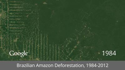
12 earthengine.google.com/timelapse

13 32 years of satellite data 5,000,000 + Landsat scenes analyzed 3 quadrillion pixels More than 2M hours of computation over 66,000 computers Elapsed time: ~1. 5 days to build the mosaics


14 The Earth Engine Public Data Catalog Our (long-term) mission: Organize all the world's Earth science data and make it universally accessible and useful, with computation on top. Today: > 200 public datasets > 6000 new images every day > 11 million images > 8 petabytes of data
15 Massive scale of Cloud-computation Parallel-processing on thousands of CPUs
16 Original Image
17 Original Image is divided into 256px sub-units.
18 Sub-units are distributed
19 Sub-units are distributed to separate machines where they can be processed in parallel.
20 Thousands can be processed simultaneously.
21 Result is reassembled
22 Result is reassembled into a finished image.

23 THE MAINBEGINNING Global Forests: Map, Measure, Monitor

24
")
25 Imagery + Compute Earth Engine (time series) StreetSmart
26 654,178 Landsat Scenes 700 Terapixels of Data Imagery + Compute Earth Engine (time series) 1,000,000 Hours of Computation 10,000 CPUs Used 4 Days to Complete StreetSmart

27

28 After citing Global Forest Watch on the floor, the Philippines House of Representatives approved a new bill prohibiting the destruction of mangrove forests. Illegal deforestation in Peru was revealed using GFW s monitoring systems.

29 "This study was made possible by free availability of satellite imagery, cloud computing services, and interactive web tools. We were able to analyze 14 years of high-resolution global forest loss data across 76 landscapes that span 13 countries." Photo: Dibyendu Ash,


30 Chasing deforestation through the clouds Lineal deforestation feature growing deep into a National Forest, identified by ISA in February using their SIRAD app on ESA Sentinel-1 radar data in Earth Engine. Confidential + Proprietary

31


32
33 Image credit: New York
34 Global-surface-water.appspot.com

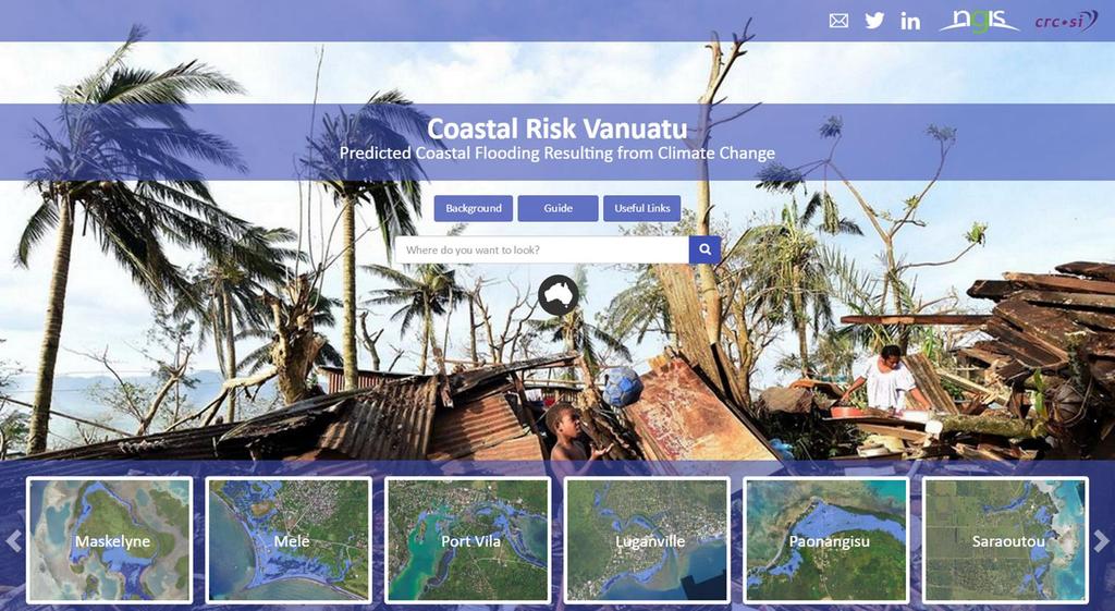
35 3,066,102 Landsat Scenes 1,823 Terapixels of Data 10,000,000 Hours of Computation 10,000 CPUs Used Global-surface-water.appspot.com

.")
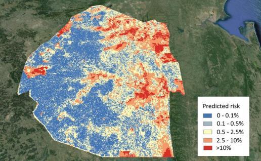
36 Processing 3 million scenes on one computer would have taken 1,212 years Processing 3 million scenes in Google s Earth Engine took 45 days Start your computer running just after Charlemagne conquers Saxony in leave it running 24 hours a day, 7 days a week and the water maps just might be ready today Charlemagne at dinner; detail of a miniature from BL Royal MS 15 E vi, f. 155r (the "Talbot Shrewsbury Book"). Held and digitised by the British Library.

37

38
39

40

41
42
43 680 Buildings in Maskelyne Community 150 Currently Inundated by High Tide 475 Inundated at High Tide by 2100

44


45 DiSARM: Maps, Machine Learning & Malaria Problem: How to prioritize villages for intervention and resource deployment, e.g. bed nets? UCSF and other orgs are using Earth Engine to generate automated highresolution malaria risk maps in Zimbabwe and Swaziland. DiSARM s mobile app can be used by the malaria programs and field teams to target interventions. The goal is to make their monitoring more efficient and effective, and to eliminate malaria in Swaziland in the next 3 years. Current maps used by the National Malaria Control Program in Swaziland. Monthly risk maps generated by the DiSARM platform, powered by Earth Engine. UCSF Global Health Group Learn more at disarm.io


46
47 Rebecca Moore, Google earth.google.com earthengine.google.com earth.google.com/outreach Thank you!
NASA Missions and Products: Update. Garik Gutman, LCLUC Program Manager NASA Headquarters Washington, DC
 NASA Missions and Products: Update Garik Gutman, LCLUC Program Manager NASA Headquarters Washington, DC 1 JPSS-2 (NOAA) SLI-TBD Formulation in 2015 RBI OMPS-Limb [[TSIS-2]] [[TCTE]] Land Monitoring at
Use of Big Data in Environmental Evaluation
 FOCUS SESSION ON USE OF NEW TECHNOLOGIES IN M&E AND IMPLICATIONS FOR EVALUATION Use of Big Data in Environmental Evaluation World Bank 19th Meeting of the DAC Network on Development Evaluation 26-27 April
Inter-Calibration of the RapidEye Sensors with Landsat 8, Sentinel and SPOT
 Inter-Calibration of the RapidEye Sensors with Landsat 8, Sentinel and SPOT Dr. Andreas Brunn, Dr. Horst Weichelt, Dr. Rene Griesbach, Dr. Pablo Rosso Content About Planet Project Context (Purpose and
Grant Boxer Consultant Geologist March 10th 2014 (Updated Nov 2014)
") Grant Boxer Consultant Geologist March 10th 2014 (Updated Nov 2014) Work flow for Landsat 8 Landgate Data Selecting and processing basic data Importing into MapInfo Applications SLIP Portal WMS access
Grant Boxer Consultant Geologist March 10th 2014 (Updated Nov 2014) Work flow for Landsat 8 Landgate Data Selecting and processing basic data Importing into MapInfo Applications SLIP Portal WMS access
OPEN DATA. POSITIVE IMPACT. INNOVATIVE TECHNOLOGIES. Radiant.Earth Annual Report,
 OPEN DATA. POSITIVE IMPACT. INNOVATIVE TECHNOLOGIES. Radiant.Earth Annual Report, 2017 www.radiant.earth Radiant.Earth drives new technology innovation and application to support the global development
Landsat 8 Pansharpen and Mosaic Geomatica 2015 Tutorial
 Landsat 8 Pansharpen and Mosaic Geomatica 2015 Tutorial On February 11, 2013, Landsat 8 was launched adding to the constellation of Earth imaging satellites. It is the seventh satellite to reach orbit
Lesson 9: Multitemporal Analysis
 Lesson 9: Multitemporal Analysis Lesson Description Multitemporal change analyses require the identification of features and measurement of their change through time. In this lesson, we will examine vegetation
Earth Observations from Space U.S. Geological Survey
 Earth Observations from Space U.S. Geological Survey Geography Land Remote Sensing Program Dr. Bryant Cramer April 1, 2009 U.S. Department of the Interior U.S. Geological Survey USGS Landsat Historical
Google earth map satellite imagery
 Zoom into new NASA satellite and aerial images of the Earth, updated every day. Interactive Map Online with Google Earth 2017 Satellite Image Hotels. Explore the far reaches of the world, right in your
Lecture 13: Remotely Sensed Geospatial Data
 Lecture 13: Remotely Sensed Geospatial Data A. The Electromagnetic Spectrum: The electromagnetic spectrum (Figure 1) indicates the different forms of radiation (or simply stated light) emitted by nature.
Accessing NASA Earth Science Data / Open Data Policy
 Accessing NASA Earth Science Data / Open Data Policy Presentation by Martha Maiden Program Executive Earth Science Data Systems NASA Headquarters martha.e.maiden@nasa.gov July 15, 2013 U.S. data policy
Tour the World with World Wind By Rob Rice
 Tour the World with World Wind By Rob Rice Lots of folks are familiar with Google Earth the free downloadable virtual globe program. Yet, I am finding that many have never heard of NASA S World Wind. World
Global Land Survey 2005
 Global Land Survey 2005 Jeff Masek, Shannon Franks, Terry Arvidson NASA GSFC Rachel Headley, Steve Covington USGS EROS April, 2008 1 Global Land Survey (GLS 2005) Follow-on to the GeoCover orthorectified
QUATERNARY PARK: RETRIEVAL OF LOST SATELLITE IMAGES FROM THE LATE 20TH CENTURY
 QUATERNARY PARK: RETRIEVAL OF LOST SATELLITE IMAGES FROM THE LATE 20TH CENTURY Grady Price Blount Department of Physical and Life Sciences Texas A & M University Corpus Christi, TX Thomas M. Holm U.S.
NASA Earth Exchange (NEX)
") NASA Earth Exchange (NEX) Ramakrishna Nemani Ames Research Center NASA Advanced Supercomputing (NAS) Division Moffett Field, CA LCLUC Meeting, Yangon, January 15, 2016 OVERVIEW + NEX is virtual collaborative
NASA Earth Exchange (NEX) Ramakrishna Nemani Ames Research Center NASA Advanced Supercomputing (NAS) Division Moffett Field, CA LCLUC Meeting, Yangon, January 15, 2016 OVERVIEW + NEX is virtual collaborative
Automated Damage Analysis from Overhead Imagery
 Automated Damage Analysis from Overhead Imagery EVAN JONES ANDRE COLEMAN SHARI MATZNER Pacific Northwest National Laboratory 1 PNNL FY2015 at a Glance $955 million in R&D expenditures 4,400 scientists,
PLANET: IMAGING THE EARTH EVERY DAY
 PLANET: IMAGING THE EARTH EVERY DAY Benjamin Trigona-Harany Mailiao Refinery, Taiwan May 31, 2016 To image the whole world every day, making change visible, accessible and actionable. HONG KONG January
Enabling Scientific Breakthroughs at the Petascale
 Enabling Scientific Breakthroughs at the Petascale Contents Breakthroughs in Science...................................... 2 Breakthroughs in Storage...................................... 3 The Impact
GEOMETRIC RECTIFICATION OF EUROPEAN HISTORICAL ARCHIVES OF LANDSAT 1-3 MSS IMAGERY
 GEOMETRIC RECTIFICATION OF EUROPEAN HISTORICAL ARCHIVES OF LANDSAT -3 MSS IMAGERY Torbjörn Westin Satellus AB P.O.Box 427, SE-74 Solna, Sweden tw@ssc.se KEYWORDS: Landsat, MSS, rectification, orbital model
The availability of cloud free Landsat TM and ETM+ land observations and implications for global Landsat data production
 14475 The availability of cloud free Landsat TM and ETM+ land observations and implications for global Landsat data production *V. Kovalskyy, D. Roy (South Dakota State University) SUMMARY The NASA funded
Online Resources: KEY FEATURES
 Explore key features of online Earth science data tools that can be useful for K 12 student investigations. Sources are color coded for relative level/ease-of-use: BLUE (introductory); ORANGE (intermediate)
Introduction. Introduction. Introduction. Introduction. Introduction
 Identifying habitat change and conservation threats with satellite imagery Extinction crisis Volker Radeloff Department of Forest Ecology and Management Extinction crisis Extinction crisis Conservationists
WGISS-42 USGS Agency Report
 WGISS-42 USGS Agency Report U.S. Department of the Interior U.S. Geological Survey Kristi Kline USGS EROS Center Major Activities Landsat Archive/Distribution Changes Land Change Monitoring, Assessment,
Status of Sentinel-1 and acquisition plans for GFOI
 Status of Sentinel-1 and acquisition plans for GFOI Frank Martin Seifert, Pierre Potin, Johannes Roeder, ESA Earth Observation Programme 5 th Space Data Coordination, ESRIN, Frascati, 24 February 2014
High-performance computing for soil moisture estimation
 High-performance computing for soil moisture estimation S. Elefante 1, W. Wagner 1, C. Briese 2, S. Cao 1, V. Naeimi 1 1 Department of Geodesy and Geoinformation, Vienna University of Technology, Vienna,
The Landsat Legacy: Monitoring a Changing Earth. U.S. Department of the Interior U.S. Geological Survey
 The Landsat Legacy: Monitoring a Changing Earth U.S. Department of the Interior U.S. Geological Survey Tom Loveland March 17, 2001 Landsat Science Mission Change is occurring at rates unprecedented in
A Web Application and Subscription Service for Landsat Forest Area Change Tools (LandsatFACT)
") A Web Application and Subscription Service for Landsat Forest Area Change Tools (LandsatFACT) Development Team N.C. Forest Service: David Jones & Brian McLean UNC Asheville s NEMAC: Jim Fox, Derek Morgan,
A Web Application and Subscription Service for Landsat Forest Area Change Tools (LandsatFACT) Development Team N.C. Forest Service: David Jones & Brian McLean UNC Asheville s NEMAC: Jim Fox, Derek Morgan,
Satellite data processing and analysis: Examples and practical considerations
 Satellite data processing and analysis: Examples and practical considerations Dániel Kristóf Ottó Petrik, Róbert Pataki, András Kolesár International LCLUC Regional Science Meeting in Central Europe Sopron,
Detection and Monitoring Through Remote Sensing....The Need For A New Remote Sensing Platform
 WILDFIRES Detection and Monitoring Through Remote Sensing...The Need For A New Remote Sensing Platform Peter Kimball ASEN 5235 Atmospheric Remote Sensing 5/1/03 1. Abstract This paper investigates the
The Global Mangrove Watch
 The Global Mangrove Watch Annual mapping of the status and changes of the world s mangroves Ake Rosenqvist and Masanobu Shimada (JAXA/Japan) Richard Lucas (Aberystwyth Univ./U.K.) Lisa Maria Rebelo (IWMI/Lao
GROßFLÄCHIGE UND HOCHFREQUENTE BEOBACHTUNG VON AGRARFLÄCHEN DURCH OPTISCHE SATELLITEN (RAPIDEYE, LANDSAT 8, SENTINEL-2)
") GROßFLÄCHIGE UND HOCHFREQUENTE BEOBACHTUNG VON AGRARFLÄCHEN DURCH OPTISCHE SATELLITEN (RAPIDEYE, LANDSAT 8, SENTINEL-2) Karsten Frotscher Produktmanager Landwirtschaft Slide 1 A Couple Of Words About The
GROßFLÄCHIGE UND HOCHFREQUENTE BEOBACHTUNG VON AGRARFLÄCHEN DURCH OPTISCHE SATELLITEN (RAPIDEYE, LANDSAT 8, SENTINEL-2) Karsten Frotscher Produktmanager Landwirtschaft Slide 1 A Couple Of Words About The
DATA STEWARDSHIP A FUNDAMENTAL PART OF THE SCIENTIFIC METHOD. Clinton Foster, Jonathon Ross, Lesley Wyborn
 DATA STEWARDSHIP A FUNDAMENTAL PART OF THE SCIENTIFIC METHOD Clinton Foster, Jonathon Ross, Lesley Wyborn Key points! Data stewardship a fundamental of science, and essential for community acceptance!
GMES DA COPERNICUS
 2014 Airbus Defence and Space All rights reserved. The reproduction, distribution and utilization of this document as well as the communication of its contents to others without express authorization is
USGS Welcome. 38 th CEOS Working Group on Calibration and Validation Plenary (WGCV-38)
") Landsat 5 USGS Welcome Prepared for 38 th CEOS Working Group on Calibration and Validation Plenary (WGCV-38) Presenter Tom Cecere International Liaison USGS Land Remote Sensing Program Elephant Butte Reservoir
Landsat 5 USGS Welcome Prepared for 38 th CEOS Working Group on Calibration and Validation Plenary (WGCV-38) Presenter Tom Cecere International Liaison USGS Land Remote Sensing Program Elephant Butte Reservoir
Visualizing a Pixel. Simulate a Sensor s View from Space. In this activity, you will:
 Simulate a Sensor s View from Space In this activity, you will: Measure and mark pixel boundaries Learn about spatial resolution, pixels, and satellite imagery Classify land cover types Gain exposure to
MONITORING LAND USE AND LAND USE CHANGES IN FRENCH GUIANA BY OPTICAL REMOTE SENSING
 MONITORING LAND USE AND LAND USE CHANGES IN FRENCH GUIANA BY OPTICAL REMOTE SENSING Photo : Valéry Gond Photo : : Valéry Gond Nicolas STACH IFN, French National Forest Inventory IFN - 32, rue Léon Bourgeois
National Aeronautics and Space Administration. Landsat Update. Jeff Masek, NASA GSFC Jim Irons, NASA GSFC. April 3, 2012 LCLUC Meeting.
 National Aeronautics and Space Administration Landsat Update Jeff Masek, NASA GSFC Jim Irons, NASA GSFC April 3, 2012 LCLUC Meeting www.nasa.gov Agenda Landsat-5/7 Update LDCM / Landsat-8 Mission Status
RADAR (RAdio Detection And Ranging)
") RADAR (RAdio Detection And Ranging) CLASSIFICATION OF NONPHOTOGRAPHIC REMOTE SENSORS PASSIVE ACTIVE DIGITAL CAMERA THERMAL (e.g. TIMS) VIDEO CAMERA MULTI- SPECTRAL SCANNERS VISIBLE & NIR MICROWAVE Real
RADAR (RAdio Detection And Ranging) CLASSIFICATION OF NONPHOTOGRAPHIC REMOTE SENSORS PASSIVE ACTIVE DIGITAL CAMERA THERMAL (e.g. TIMS) VIDEO CAMERA MULTI- SPECTRAL SCANNERS VISIBLE & NIR MICROWAVE Real
Managing Imagery and Raster Data. Peter Becker
 Managing Imagery and Raster Data Peter Becker ArcGIS is a Comprehensive Imagery Platform Empowering you to make informed decisions System of Engagement System of Insight Extract Information from Imagery
Lesson 3: Working with Landsat Data
 Lesson 3: Working with Landsat Data Lesson Description The Landsat Program is the longest-running and most extensive collection of satellite imagery for Earth. These datasets are global in scale, continuously
The USGEO Satellite Needs process provides the firstever whole-of-government approach to identifying desired satellite products across the civilian
 Observations (USGEO) Satellite Needs Identifying Federal Satellite User Needs Glenn Bethel / USDA SNWG Co-Chair The USGEO Satellite Needs process provides the firstever whole-of-government approach to
HARRIS GEOSPATIAL MARKETPLACE. HarrisGeospatial.com
 HARRIS GEOSPATIAL MARKETPLACE HarrisGeospatial.com Satellite image of Washington, D.C. Image courtesy of DigitalGlobe GET IT ALL IN ONE PLACE Data for Any Project Map Products Vis/Sim Products Geospatial
Field size estimation, past and future opportunities
 Field size estimation, past and future opportunities Lin Yan & David Roy Geospatial Sciences Center of Excellence South Dakota State University February 13-15 th 2018 Advances in Emerging Technologies
Global Land Survey Activities and Land Cover Analysis from Landsat
 Global Land Survey Activities and Land Cover Analysis from Landsat Shannon Franks, SGT/NASA Jeffrey G. Masek, NASA GSFC Garik Gutman, NASA HQ Rachel Headley, USGS CODATA, October 25, 2010 Background the
2017 REMOTE SENSING EVENT TRAINING STRATEGIES 2016 SCIENCE OLYMPIAD COACHING ACADEMY CENTERVILLE, OH
 2017 REMOTE SENSING EVENT TRAINING STRATEGIES 2016 SCIENCE OLYMPIAD COACHING ACADEMY CENTERVILLE, OH This presentation was prepared using draft rules. There may be some changes in the final copy of the
Green/Blue Metrics Meeting June 20, 2017 Summary
 Short round table introductions of participants Paul Villenueve, Carleton, Co-lead Green/Blue, Matilda van den Bosch, UBC, Co-lead Green/Blue Dan Crouse, UNB Lorien Nesbitt, UBC Audrey Smargiassi, Uof
Satellite Remote Sensing: Earth System Observations
 Satellite Remote Sensing: Earth System Observations Land surface Water Atmosphere Climate Ecosystems 1 EOS (Earth Observing System) Develop an understanding of the total Earth system, and the effects of
Deep Learning for Infrastructure Assessment in Africa using Remote Sensing Data
 Deep Learning for Infrastructure Assessment in Africa using Remote Sensing Data Pascaline Dupas Department of Economics, Stanford University Data for Development Initiative @ Stanford Center on Global
DEEP LEARNING A NEW COMPUTING MODEL. Sundara R Nagalingam Head Deep Learning Practice
 DEEP LEARNING A NEW COMPUTING MODEL Sundara R Nagalingam Head Deep Learning Practice snagalingam@nvidia.com THE ERA OF AI AI CLOUD MOBILE PC 2 DEEP LEARNING Raw data Low-level features Mid-level features
PILOTING A DECISION SUPPORT TOOL (DST) FOR MAPPING CYANOBACTERIAL HARMFUL ALGAL BLOOMS (CHABS) TO SUPPORT PUBLIC HEALTH AND RESOURCE MANAGEMENT.
 FOR MAPPING CYANOBACTERIAL HARMFUL ALGAL BLOOMS (CHABS) TO SUPPORT PUBLIC HEALTH AND RESOURCE MANAGEMENT.") PILOTING A DECISION SUPPORT TOOL (DST) FOR MAPPING CYANOBACTERIAL HARMFUL ALGAL BLOOMS (CHABS) TO SUPPORT PUBLIC HEALTH AND RESOURCE MANAGEMENT. Nathan Torbick, Applied Geosolutions Scott Stoodley, Director,
PILOTING A DECISION SUPPORT TOOL (DST) FOR MAPPING CYANOBACTERIAL HARMFUL ALGAL BLOOMS (CHABS) TO SUPPORT PUBLIC HEALTH AND RESOURCE MANAGEMENT. Nathan Torbick, Applied Geosolutions Scott Stoodley, Director,
Monitoring Natural Disasters with Small Satellites Smart Satellite Based Geospatial System for Environmental Protection
 Monitoring Natural Disasters with Small Satellites Smart Satellite Based Geospatial System for Environmental Protection Krištof Oštir, Space-SI, Slovenia Contents Natural and technological disasters Current
Satellite Monitoring of a Large Tailings Storage Facility
 Satellite Monitoring of a Large Tailings Storage Facility Benjamin Schmidt and Matt Malgesini, Golder Associates Inc., USA Jim Turner, PhotoSat Ltd, Canada Jeff Reinson, Goldcorp Inc., Canada Presentation
Remote Sensing Data Sources Outlook
 Remote Sensing Data Sources Outlook Dr Arnold Dekker Earth Observation Informatics FSP UN Big Data for Official Statistics Abu Dhabi 20-22 nd October 2015 EARTH OBSERVATION INFORMATICS FUTURE SCIENCE PLATFORM
2016 Winter. / ASF News & Notes / 2016 Winter
 Home Get Data Datasets Data Tools About SAR News About ASF / ASF News & Notes / 2016 Winter Latest News 2016 Winter 2014 Fall 2014 Spring 2013 Summer 2013 Spring 2012 Winter 2012 Fall 2012 Summer 2012
Monitoring agricultural plantations with remote sensing imagery
 MPRA Munich Personal RePEc Archive Monitoring agricultural plantations with remote sensing imagery Camelia Slave and Anca Rotman University of Agronomic Sciences and Veterinary Medicine - Bucharest Romania,
Practical Uses of Satellite Data in Forest Management
 Practical Uses of Satellite Data in Forest Management GCFF Conference April 2018 Copernicus: Sentinel-2 The Optical Imaging Mission for Land Services 1 Uses for Satellite Imagery 1. Introduction 2. Satellite
Introduction to Remote Sensing
 Introduction to Remote Sensing Outline Remote Sensing Defined Resolution Electromagnetic Energy (EMR) Types Interpretation Applications Remote Sensing Defined Remote Sensing is: The art and science of
Satellite Imagery and Remote Sensing. DeeDee Whitaker SW Guilford High EES & Chemistry
 Satellite Imagery and Remote Sensing DeeDee Whitaker SW Guilford High EES & Chemistry whitakd@gcsnc.com Outline What is remote sensing? How does remote sensing work? What role does the electromagnetic
Workshop on Application of Satellite Technologies for Emergencies Preparedness, Management and Response in Asia-Pacific Region - Presentation
 2013/SOM1/EPWG/008a Agenda Item: 8.1.2 Workshop on Application of Satellite Technologies for Emergencies Preparedness, Management and Response in Asia-Pacific Region - Presentation Purpose: Information
Google Earth Engine Image Pre-processing Tool: User guide
 Google Earth Engine Image Pre-processing Tool: Lukas Würsch, Kaspar Hurni, and Andreas Heinimann Centre for Development and Environment (CDE) University of Bern 2017 Introduction The image pre-processing
White paper brief IdahoView Imagery Services: LISA 1 Technical Report no. 1 Processing and Evaluation
 White paper brief IdahoView Imagery Services: LISA 1 Technical Report no. 1 Processing and Evaluation Keith T. Weber, GISP, GIS Director, Idaho State University, 921 S. 8th Ave., stop 8104, Pocatello,
PROGRESS IN ADDRESSING SCIENCE GOALS FOR GLACIER OBSERVATIONS BY MEANS OF SAR. Frank Paul & Thomas Nagler
 PROGRESS IN ADDRESSING SCIENCE GOALS FOR GLACIER OBSERVATIONS BY MEANS OF SAR Frank Paul & Thomas Nagler SAR Coordination Working Group Meeting, 13/11/2016 Observed glacier products and sensors Product
Data acquisition and access for the Congo Basin
 MRV Joint Workshop 22-24 June 2010, Guadalajara, Jalisco Mexico Data acquisition and access for the Congo Basin Landing Mané 1, Michael Brady 2, Chris Justice 3 and Alice Altstatt 3 1) Satellite Observatory
JECAM/SEN2AGRI CROSS SITES
 JECAM/SEN2AGRI CROSS SITES BENCHMARKING FOR CROP TYPE JECAM Annual Science Meeting 16-17 November 2015 Brussels, Belgium Sen2-Agri QR Meeting -ESRIN -October 30, 2015 CROP-TYPE PRODUCT Delivered as soon
DEVELOPMENT OF A NEW SOUTH AFRICAN LAND-COVER DATASET USING AUTOMATED MAPPING TECHINQUES. Mark Thompson 1
 DEVELOPMENT OF A NEW SOUTH AFRICAN LAND-COVER DATASET USING AUTOMATED MAPPING TECHINQUES. Mark Thompson 1 1 GeoTerraImage Pty Ltd, Pretoria, South Africa Abstract This talk will discuss the development
Warren Cartwright, Product Manager MDA Geospatial Services, Canada
 Advanced InSAR Techniques for Urban Infrastructure Monitoring Warren Cartwright, Product Manager MDA Geospatial Services, Canada www.mdacorporation.com RESTRICTION ON USE, PUBLICATION OR DISCLOSURE OF
NORMALIZING ASTER DATA USING MODIS PRODUCTS FOR LAND COVER CLASSIFICATION
 NORMALIZING ASTER DATA USING MODIS PRODUCTS FOR LAND COVER CLASSIFICATION F. Gao a, b, *, J. G. Masek a a Biospheric Sciences Branch, NASA Goddard Space Flight Center, Greenbelt, MD 20771, USA b Earth
Landsat Program Update
 Landsat Program Update Timothy Stryker Chief, Outreach and Collaboration Branch National Land Imaging Program Western States Water Council Spring Meetings March 19-22, 2019 Chandler, Arizona U.S. Geological
Japan's Greenhouse Gases Observation from Space
 1 Workshop on EC CEOS Priority on GHG Monitoring Japan's Greenhouse Gases Observation from Space 18 June, 2018@Ispra, Italy Masakatsu NAKAJIMA Japan Aerospace Exploration Agency Development and Operation
Satellite image classification
 Satellite image classification EG2234 Earth Observation Image Classification Exercise 29 November & 6 December 2007 Introduction to the practical This practical, which runs over two weeks, is concerned
ARGOS satellite system status & improvements
 PAGE 1 ARGOS satellite system status & improvements Yann Bernard CLS, Oceanography AST 14 th meeting, Wellington, New-Zealand METOP-B & SARAL satellites 2 new Argos satellites recently successfully launched!!!
Rapideye (2008 -> ) Not just another high resolution satellite sensor. 5 satellites RapidEye constellation. 5 million km² daily collection capacity
 Not just another high resolution satellite sensor. 5 satellites RapidEye constellation. 5 million km² daily collection capacity") Rapideye (2008 -> ) Not just another high resolution satellite sensor 5 satellites RapidEye constellation 5 million km² daily collection capacity Price: $1.40 / sq km ($2.50 rectified) Orbit: http://www.youtube.com/watch?feature=player_embedded&v=ovpulctoqgs
Rapideye (2008 -> ) Not just another high resolution satellite sensor 5 satellites RapidEye constellation 5 million km² daily collection capacity Price: $1.40 / sq km ($2.50 rectified) Orbit: http://www.youtube.com/watch?feature=player_embedded&v=ovpulctoqgs
LANDSAT 8 Level 1 Product Performance
 Réf: IDEAS-TN-10-CyclicReport LANDSAT 8 Level 1 Product Performance Cyclic Report Month/Year: May 2015 Date: 25/05/2015 Issue/Rev:1/0 1. Scope of this document On May 30, 2013, data from the Landsat 8
Sharing Oblique and Oriented Imagery. Cody Benkelman Cristelle D Souza UC2018
 Sharing Oblique and Oriented Imagery Cody Benkelman Cristelle D Souza UC2018 Image Orientation Image Orientation Mosaic Dataset Image Orientation Oriented Imagery Oblique Imagery Oblique imagery modes
to Geospatial Technologies
 What s in a Pixel? A Primer for Remote Sensing What s in a Pixel Development UNH Cooperative Extension Geospatial Technologies Training Center Shane Bradt UConn Cooperative Extension Geospatial Technology
Climate and Space. Leina Hutchinson April 8, 2019
 Climate and Space Leina Hutchinson April 8, 2019 NASA Background Originally founded as NACA (National Advisory Committee for Aeronautics) in 1915 Became NASA (National Aeronautics and Space Administration)
Application of Satellite Remote Sensing for Natural Disasters Observation
 Application of Satellite Remote Sensing for Natural Disasters Observation Prof. Krištof Oštir, Ph.D. University of Ljubljana Faculty of Civil and Geodetic Engineering Outline Earth observation current
DISTINGUISHING URBAN BUILT-UP AND BARE SOIL FEATURES FROM LANDSAT 8 OLI IMAGERY USING DIFFERENT DEVELOPED BAND INDICES
 DISTINGUISHING URBAN BUILT-UP AND BARE SOIL FEATURES FROM LANDSAT 8 OLI IMAGERY USING DIFFERENT DEVELOPED BAND INDICES Mark Daryl C. Janiola (1), Jigg L. Pelayo (1), John Louis J. Gacad (1) (1) Central
29 th Annual Louisiana RS/GIS Workshop April 23, 2013 Cajundome Convention Center Lafayette, Louisiana
 Landsat Data Continuity Mission 29 th Annual Louisiana RS/GIS Workshop April 23, 2013 Cajundome Convention Center Lafayette, Louisiana http://landsat.usgs.gov/index.php# Landsat 5 Sets Guinness World Record
Landsat: Today and Future Missions WSWC, Helena MT, July 15-18, 2014
 Landsat: Today and Future Missions WSWC, Helena MT, July 15-18, 2014 U.S. Department of the Interior U.S. Geological Survey Landsat 8 Operational Land Imager (OLI) October 22, 2013 Helena, MT Bands 4,3,2-8
Raster is faster but vector is corrector
 Account not required Raster is faster but vector is corrector The old GIS adage raster is faster but vector is corrector comes from the two different fundamental GIS models: vector and raster. Each of
OUR INDUSTRIAL LEGACY WHAT ARE WE LEAVING OUR CHILDREN REAAA Roadshow Taupo, August 2016 Young presenter s competition
 OUR INDUSTRIAL LEGACY WHAT ARE WE LEAVING OUR CHILDREN Preserving the country s aerial photography archive for future generations Abstract For over eighty years, aerial photography has captured the changing
Downloading and formatting remote sensing imagery using GLOVIS
 Downloading and formatting remote sensing imagery using GLOVIS Students will become familiarized with the characteristics of LandSat, Aerial Photos, and ASTER medium resolution imagery through the USGS
AT-SATELLITE REFLECTANCE: A FIRST ORDER NORMALIZATION OF LANDSAT 7 ETM+ IMAGES
 AT-SATELLITE REFLECTANCE: A FIRST ORDER NORMALIZATION OF LANDSAT 7 ETM+ IMAGES Chengquan Huang*, Limin Yang, Collin Homer, Bruce Wylie, James Vogelman and Thomas DeFelice Raytheon ITSS, EROS Data Center
Data Requirements Definition and Data Services Options for RAPP
 Data Requirements Definition and Data Services Options for RAPP Brian Killough CEOS Systems Engineering Office (SEO) 5 th GEOGLAM RAPP Workshop Frascati, Italy May 16-17, 2017 Requirements Update The observation
Remote Sensing Analysis Framework for Maritime Surveillance Application
 Remote Sensing Analysis Framework for Maritime Surveillance Application Olaf Frauenberger, Egbert Schwarz, Sergey Voinov Maritime Security Lab Neustrelitz (DFD) Maritime Big Data Workshop, 9-11 May, La
Please show the instructor your downloaded index files and orthoimages.
 Student Exercise 1: Sandia Forest Infestation Acquiring Orthophotos and Satellite Imagery Please show the instructor your downloaded index files and orthoimages. Objectives: Determine appropriate imagery
Image interpretation. Aliens create Indian Head with an ipod? Badlands Guardian (CBC) This feature can be found 300 KMs SE of Calgary.
 This feature can be found 300 KMs SE of Calgary.") Image interpretation Aliens create Indian Head with an ipod? Badlands Guardian (CBC) This feature can be found 300 KMs SE of Calgary. 50 1 N 110 7 W Milestones in the History of Remote Sensing 19 th century
Image interpretation Aliens create Indian Head with an ipod? Badlands Guardian (CBC) This feature can be found 300 KMs SE of Calgary. 50 1 N 110 7 W Milestones in the History of Remote Sensing 19 th century
Remote Sensing in an
 Chapter 8. Downloading Landsat Imagery using Earth Explorer Remote Sensing in an ArcMap Environment Remote Sensing Analysis in an ArcMap Environment Tammy E. Parece Image source: landsat.usgs.gov Tammy
Sommersemester Prof. Dr. Christoph Kleinn Institut für Waldinventur und Waldwachstum Arbeitsbereich Fernerkundung und Waldinventur.
 Basics of Remote Sensing Some literature references Franklin, SE 2001 Remote Sensing for Sustainable Forest Management Lewis Publishers 407p Lillesand, Kiefer 2000 Remote Sensing and Image Interpretation
How to Access Imagery and Carry Out Remote Sensing Analysis Using Landsat Data in a Browser
 How to Access Imagery and Carry Out Remote Sensing Analysis Using Landsat Data in a Browser Including Introduction to Remote Sensing Concepts Based on: igett Remote Sensing Concept Modules and GeoTech
Standard Chartered PLC Board Member Visits Ghana
 Standard Chartered PLC Board Member Visits Ghana Accra 4 June 2006 -- Mr. Richard Meddings, member of the Board of Standard Chartered PLC and Group Executive Director of Standard Chartered Bank with responsibility
KÜNSTLICHE INTELLIGENZ JOBKILLER VON MORGEN?
 KÜNSTLICHE INTELLIGENZ JOBKILLER VON MORGEN? Marc Stampfli https://www.linkedin.com/in/marcstampfli/ https://twitter.com/marc_stampfli E-Mail: mstampfli@nvidia.com INTELLIGENT ROBOTS AND SMART MACHINES
Mapping Open Water Bodies with Optical Remote Sensing
 Mapping Open Water Bodies with Optical Remote Sensing M. O Donnell 1,2 and E. Podest 1 1.Jet Propulsion Laboratory, California Institute of Technology 2 Alliance Gertz-Ressler High School, Los Angeles,
On the use of water color missions for lakes in 2021
 Lakes and Climate: The Role of Remote Sensing June 01-02, 2017 On the use of water color missions for lakes in 2021 Cédric G. Fichot Department of Earth and Environment 1 Overview 1. Past and still-ongoing
Treasure your archive
 Océ 3050 Treasure your archive Microfilm aperture card scanner for an integrated digital workflow Increase productivity with the Océ 3050 Batch processing Aperture cards to digital archive Quality, flexibility,
Chapter 1 Overview of imaging GIS
 Chapter 1 Overview of imaging GIS Imaging GIS, a term used in the medical imaging community (Wang 2012), is adopted here to describe a geographic information system (GIS) that displays, enhances, and facilitates
Land Remote Sensing Lab 4: Classication and Change Detection Assigned: October 15, 2017 Due: October 27, Classication
 Name: Land Remote Sensing Lab 4: Classication and Change Detection Assigned: October 15, 2017 Due: October 27, 2017 In this lab, you will generate several gures. Please sensibly name these images, save
Web Meets World Tim O Reilly O Reilly Media, Inc. Web 2.0 Expo Berlin October 21, 2008
 Web Meets World Tim O Reilly O Reilly Media, Inc. www.oreilly.com Web 2.0 Expo Berlin October 21, 2008 Something here about end of Web 2.0 web2.over 2 Deep trends behind Web 2.0 The internet as platform
Geospatial Technologies and Human Rights Project
 Geospatial Technologies and Human Rights Project Negeha, South Darfur: High-Resolution Satellite Imagery and Destruction of Housing Structures Negeha This report was produced by the Geospatial Technologies