Super Resolution with GF-4 for Finer Scale Earth Observing
|
|
|
- Edwin Gallagher
- 5 years ago
- Views:
Transcription


1 Super Resolution with GF-4 for Finer Scale Earth Observing Dr. Feng Li 8th Annual UN-SPIDER Conference

2 1 Backgrounds Gaofen 4 (GF 4) is a geostationary disaster relief satellite in the Gaofen series of Chinese civilian remote sensing satellites,which was launched on December 28, Each snapshot covers around 400 x 400 Square kilometres. A ground resolution of 50 meters is achieved in the visible wavelengths while the midwavelength infrared with 400 meters. Channel Wavelength (um) Spatial resolution (m) Field of view (km) Revisit cycle (seconds) Visible and near-infrared ~ ~ ~ ~ ~0.90 Mid-wavelength infrared 6 3.5~
,where F # is the f- number; It limits the spatial resolution that can be imaged with sensors; The Nyquist frequency for a sensor is defined as Nyquist = 1/2p (lp/mm), where p is the pixel")
3 Resolution: Definition: the ability to detect two closely spaced objects Twofold meaning: optical resolution and sensor resolution The optical cutoff frequency for an imaging system is 1/λ F # (lp/mm),where F # is the f- number; It limits the spatial resolution that can be imaged with sensors; The Nyquist frequency for a sensor is defined as Nyquist = 1/2p (lp/mm), where p is the pixel size; Bear in mind: λ F # /p=2 is perfect, but nothing is perfect Most of earth observing systems follows: λ F # /p<2 卫星 F # 像元尺寸 p (μm) λ F # /p GF


4 2 Super Resolution(SR) SR: restoring a high spatial resolution image from a series of low resolution images of the same scene SR Target detection Disaster relief Classification accuracy Lower cost n Make full use of remote sensing resources in orbit or in disk; n Lower the cost for the future optical remote sensing satellites;


5 3 HR Image z Group Sparse Representations based SR Warping M 1 Blur H 1 Downsampling D 1 Noise n 1 g 1 LR Images { } K i = Di HiMiz + ni i { g } K i i= 1 g = 1 z? ill-posed problem M K H K D K n K g K Group Sparse Representations (GSR) is proposed for solving ill-conditioned problem SR, GSR is regarded as a prior for Maximum a Posterior Imaging Procedure

6 Registration is an important step in SR,an elastic registration is proposed; Before After After Before After


7 超分辨率重构 超分辨率重构 超分辨率重构 超分辨率重构 CMOS 相机获取的图像 图像拼接 卫星运动方向 Moving target Sampling efficiency improves 46%
 4")


8 Original SR (2X GSD) 4 Experiments with GaoFen-4 Advantages: n High tempal resolution n CMOS array n Geo-stationary n Staring imaging Panchromatic band test Beijing, 3 frames within 2days Forbidden city


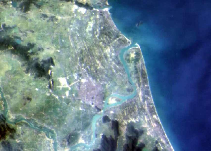
9 Panchromatic band test Original SR Original SR Google Earth Wanning, Hainan Provience,7frames on 26 Aug,2016
10 South of Hainan Original

11 South of Hainan SR


12 GF-4,Source Image GF-4,super-resolution Vietnam, images within minutes


13 Original Original SR Original SR SR 实景 Google Earth Google Earth SanYa, Hainan


14 Mid-wavelength infrared test Hainan Province Beijing Different scenes contain similar noise pattern
 are not suppose to have over 4 difference. The super resolved red box 28.2 28.3 25.7 28.0 27.3 27.")

15 Mid-wavelength infrared test(1) Temperature retrieved from the SR image is more reliable. One LR from Datacube Interpolated the red box Two neighbor pixels sea temperature (within 800 meters) are not suppose to have over 4 difference. The super resolved red box
 N20.")


16 Mid-wavelength infred test(2) N20.8 Longitude E103.0 E103.6 E104.2 E104.8 N20.6 N20.3 Latitude N20.1 N19.8 N19.6 Central area locates the border of Vietnam and Laos 37 frames within about 1 hour :30:01~15:25:21 Data fusion along time series

17 5 Conclusions n SR benifits:detection,measure,sub-pixel classification n SR reconstruction is possible, but not always! (needs aliasing, accurate image registration, enough frames, ). n Make full use of remote sensing resources in orbit or in disk; decrease the cost for the future optical remote sensing satellites n Airborn based CMOS cameras bring hopes ØDigital Time Delay Integration(TDI) ØSuper Resolution ØModulation Transfer Function Compensation (MTF ) Digital TDI SR MTFC
18 5 Relevant publications Journal Papers: [1] F. Li, L. Xin, Y. Guo, D Gao, X. Kong, X. Jia, Super Resolution for GaoFen-4 Remote Sensing Images, IEEE Geoscience and Remote Sensing Letters, Volume: 15 Issue: 1, 2018 [2] F. Li, L. Xin, Y. Guo, J. Gao, and X. Jia, A Framework of Mixed Sparse Representations for Remote Sensing Images, IEEE Transactions on Geoscience and Remote Sensing, Volume: 55, Issue: 2, Pages: , 2017 [3]Y. Guo, J.B. Gao, F. Li, Random Spatial Subspace Clustering, Knowledge-Based Systems, Vol 74, pp , 2015 [4] F. Li, C. Li, L Tang, Y.Guo, Elastic registration for airborne multispectral line scanners, J. Appl. Remote Sens., 8(1), (2014) [5] Y. Guo, J.B. Gao, F. Li, Spatial subspace clustering for drill hole spectral data. J.Appl. Remote Sens. 8 (1), (April 28, 2014); doi: /1.JRS [6] F. Li, S.Brown, T.Cornwell, and F. De Hoog. The Application of Compressive Sampling to Radio Astronomy II: Faraday Rotation Measure Synthesis, Astronomy & Astrophysics, Vol 531, 2011 [7] F. Li, T.Cornwell, and F. De Hoog. The Application of Compressive Sampling to Radio Astronomy I: Deconvolution, Astronomy & Astrophysics, Vol 528, 2011 [8] F. Li, X. Jia, D. Fraser and A. Lambert. Super resolution for remote sensing images based on a universal hidden Markov tree model. IEEE Transactions on Geoscience and Remote Sensing, Vol 48, Issue: 3, Pages: , [9]F. Li, X. Jia, and D. Fraser. Super resolution reconstruction of multi-spectral data for improved image Classification. IEEE Geoscience and Remote Sensing Letters, Vol 6, Issue: 4, Pages: , [10]F. Li, D. Fraser and X. Jia. Improved IBP for Super-resolving Remote Sensing Images. CPGIS, Vol.12, No.2, Pages , 2006 Books: [1] Introduction of Compressive Sensing Feng Li Yi Guo, ISBN: ,Science China Press, 2015 [2]Feng Li,Xiuping Jia, Donald Fraser, Andrew Lambert, Super resolution for multispectral image classification, in the book Image Restoration: Fundamentals and Advances, ISBN-13: , Taylor and Francis, 2012 Patents: [1]Group Group Sparse Representations based super resolution, , Feng Li,Lei Xin,Kun Zhan,Granted
Brief introduction on Chinese ocean colour satellite missions
 卫星海洋环境动力学国家重点实验室 Brief introduction on Chinese ocean colour satellite missions Zhihua Mao, Delu Pan State Key Laboratory of Satellite Ocean Environment Dynamics, Second Institute of Oceanography, SOA 卫星海洋环境动力学国家重点实验室国家海洋局第二海洋研究所
An Introduction to Geomatics. Prepared by: Dr. Maher A. El-Hallaq خاص بطلبة مساق مقدمة في علم. Associate Professor of Surveying IUG
 An Introduction to Geomatics خاص بطلبة مساق مقدمة في علم الجيوماتكس Prepared by: Dr. Maher A. El-Hallaq Associate Professor of Surveying IUG 1 Airborne Imagery Dr. Maher A. El-Hallaq Associate Professor
Super-Resolution of Multispectral Images
 IJSRD - International Journal for Scientific Research & Development Vol. 1, Issue 3, 2013 ISSN (online): 2321-0613 Super-Resolution of Images Mr. Dhaval Shingala 1 Ms. Rashmi Agrawal 2 1 PG Student, Computer
Blind Single-Image Super Resolution Reconstruction with Defocus Blur
 Sensors & Transducers 2014 by IFSA Publishing, S. L. http://www.sensorsportal.com Blind Single-Image Super Resolution Reconstruction with Defocus Blur Fengqing Qin, Lihong Zhu, Lilan Cao, Wanan Yang Institute
CHARACTERISTICS OF REMOTELY SENSED IMAGERY. Spatial Resolution
 CHARACTERISTICS OF REMOTELY SENSED IMAGERY Spatial Resolution There are a number of ways in which images can differ. One set of important differences relate to the various resolutions that images express.
SUPER RESOLUTION INTRODUCTION
 SUPER RESOLUTION Jnanavardhini - Online MultiDisciplinary Research Journal Ms. Amalorpavam.G Assistant Professor, Department of Computer Sciences, Sambhram Academy of Management. Studies, Bangalore Abstract:-
Remote Sensing Platforms
 Types of Platforms Lighter-than-air Remote Sensing Platforms Free floating balloons Restricted by atmospheric conditions Used to acquire meteorological/atmospheric data Blimps/dirigibles Major role - news
Int n r t o r d o u d c u ti t on o n to t o Remote Sensing
 Introduction to Remote Sensing Definition of Remote Sensing Remote sensing refers to the activities of recording/observing/perceiving(sensing)objects or events at far away (remote) places. In remote sensing,
Remote Sensing in Daily Life. What Is Remote Sensing?
 Remote Sensing in Daily Life What Is Remote Sensing? First time term Remote Sensing was used by Ms Evelyn L Pruitt, a geographer of US in mid 1950s. Minimal definition (not very useful): remote sensing
Chapter 1. Introduction
 Chapter 1 Introduction One of the major achievements of mankind is to record the data of what we observe in the form of photography which is dated to 1826. Man has always tried to reach greater heights
IKONOS High Resolution Multispectral Scanner Sensor Characteristics
 High Spatial Resolution and Hyperspectral Scanners IKONOS High Resolution Multispectral Scanner Sensor Characteristics Launch Date View Angle Orbit 24 September 1999 Vandenberg Air Force Base, California,
National Remote Sensing Center of China Agency Report
 National Remote Sensing Center of China Agency Report Presented by Chuanrong Li National Remote Sensing Center of China Ministry of Science and Technology, P. R. China Feb. 2014 CEOS/WGCV-37 Plenary Outline
The studies began when the Tiros satellites (1960) provided man s first synoptic view of the Earth s weather systems.
 provided man s first synoptic view of the Earth s weather systems.") Remote sensing of the Earth from orbital altitudes was recognized in the mid-1960 s as a potential technique for obtaining information important for the effective use and conservation of natural resources.
Remote sensing of the Earth from orbital altitudes was recognized in the mid-1960 s as a potential technique for obtaining information important for the effective use and conservation of natural resources.
1. INTRODUCTION. GOCI : Geostationary Ocean Color Imager
 1. INTRODUCTION The Korea Ocean Research and Development Institute (KORDI) releases an announcement of opportunity (AO) to carry out scientific research for the utilization of GOCI data. GOCI is the world
REMOTE SENSING. Topic 10 Fundamentals of Digital Multispectral Remote Sensing MULTISPECTRAL SCANNERS MULTISPECTRAL SCANNERS
 REMOTE SENSING Topic 10 Fundamentals of Digital Multispectral Remote Sensing Chapter 5: Lillesand and Keifer Chapter 6: Avery and Berlin MULTISPECTRAL SCANNERS Record EMR in a number of discrete portions
FUNDAMENTALS OF DIGITAL IMAGES
 FUNDAMENTALS OF DIGITAL IMAGES Lecture Image Data Structures Common Data Structures to Store Multiband Data BIL band interleaved by line BSQ band sequential BIP band interleaved by pixel Example Band Band
High resolution images obtained with uncooled microbolometer J. Sadi 1, A. Crastes 2
 High resolution images obtained with uncooled microbolometer J. Sadi 1, A. Crastes 2 1 LIGHTNICS 177b avenue Louis Lumière 34400 Lunel - France 2 ULIS SAS, ZI Veurey Voroize - BP27-38113 Veurey Voroize,
International Journal of Innovative Research in Engineering Science and Technology APRIL 2018 ISSN X
 HIGH DYNAMIC RANGE OF MULTISPECTRAL ACQUISITION USING SPATIAL IMAGES 1 M.Kavitha, M.Tech., 2 N.Kannan, M.E., and 3 S.Dharanya, M.E., 1 Assistant Professor/ CSE, Dhirajlal Gandhi College of Technology,
Module 3 Introduction to GIS. Lecture 8 GIS data acquisition
 Module 3 Introduction to GIS Lecture 8 GIS data acquisition GIS workflow Data acquisition (geospatial data input) GPS Remote sensing (satellites, UAV s) LiDAR Digitized maps Attribute Data Management Data
Satellite/Aircraft Imaging Systems Imaging Sensors Standard scanner designs Image data formats
 CEE 6150: Digital Image Processing 1 Satellite/Aircraft Imaging Systems Imaging Sensors Standard scanner designs Image data formats CEE 6150: Digital Image Processing 2 CEE 6150: Digital Image Processing
BEMD-based high resolution image fusion for land cover classification: A case study in Guilin
 IOP Conference Series: Earth and Environmental Science PAPER OPEN ACCESS BEMD-based high resolution image fusion for land cover classification: A case study in Guilin To cite this article: Lei Li et al
Cloud-removing Algorithm of Short-period Terms for Geostationary Satellite
 JOURNAL OF SIMULATION, VOL. 6, NO. 4, Aug. 2018 9 Cloud-removing Algorithm of Short-period Terms for Geostationary Satellite Weidong. Li a, Chenxi Zhao b, Fanqian. Meng c College of Information Engineering,
Some Basic Concepts of Remote Sensing. Lecture 2 August 31, 2005
 Some Basic Concepts of Remote Sensing Lecture 2 August 31, 2005 What is remote sensing Remote Sensing: remote sensing is science of acquiring, processing, and interpreting images and related data that
Abstract Quickbird Vs Aerial photos in identifying man-made objects
 Abstract Quickbird Vs Aerial s in identifying man-made objects Abdullah Mah abdullah.mah@aramco.com Remote Sensing Group, emap Division Integrated Solutions Services Department (ISSD) Saudi Aramco, Dhahran
On the use of water color missions for lakes in 2021
 Lakes and Climate: The Role of Remote Sensing June 01-02, 2017 On the use of water color missions for lakes in 2021 Cédric G. Fichot Department of Earth and Environment 1 Overview 1. Past and still-ongoing
Image Restoration and Super- Resolution
 Image Restoration and Super- Resolution Manjunath V. Joshi Professor Dhirubhai Ambani Institute of Information and Communication Technology, Gandhinagar, Gujarat email:mv_joshi@daiict.ac.in Overview Image
Sensor resolutions from space: the tension between temporal, spectral, spatial and swath. David Bruce UniSA and ISU
 Sensor resolutions from space: the tension between temporal, spectral, spatial and swath David Bruce UniSA and ISU 1 Presentation aims 1. Briefly summarize the different types of satellite image resolutions
Digital images. Digital Image Processing Fundamentals. Digital images. Varieties of digital images. Dr. Edmund Lam. ELEC4245: Digital Image Processing
 Digital images Digital Image Processing Fundamentals Dr Edmund Lam Department of Electrical and Electronic Engineering The University of Hong Kong (a) Natural image (b) Document image ELEC4245: Digital
Introduction to Remote Sensing Fundamentals of Satellite Remote Sensing. Mads Olander Rasmussen
 Introduction to Remote Sensing Fundamentals of Satellite Remote Sensing Mads Olander Rasmussen (mora@dhi-gras.com) 01. Introduction to Remote Sensing DHI What is remote sensing? the art, science, and technology
DESIS Applications & Processing Extracted from Teledyne & DLR Presentations to JACIE April 14, Ray Perkins, Teledyne Brown Engineering
 DESIS Applications & Processing Extracted from Teledyne & DLR Presentations to JACIE April 14, 2016 Ray Perkins, Teledyne Brown Engineering 1 Presentation Agenda Imaging Spectroscopy Applications of DESIS
Remote Sensing Platforms
 Remote Sensing Platforms Remote Sensing Platforms - Introduction Allow observer and/or sensor to be above the target/phenomena of interest Two primary categories Aircraft Spacecraft Each type offers different
9/12/2011. Training Course Remote Sensing Basic Theory & Image Processing Methods September 2011
 Training Course Remote Sensing Basic Theory & Image Processing Methods 19 23 September 2011 Popular Remote Sensing Sensors & their Selection Michiel Damen (September 2011) damen@itc.nl 1 Overview Low resolution
NON-PHOTOGRAPHIC SYSTEMS: Multispectral Scanners Medium and coarse resolution sensor comparisons: Landsat, SPOT, AVHRR and MODIS
 NON-PHOTOGRAPHIC SYSTEMS: Multispectral Scanners Medium and coarse resolution sensor comparisons: Landsat, SPOT, AVHRR and MODIS CLASSIFICATION OF NONPHOTOGRAPHIC REMOTE SENSORS PASSIVE ACTIVE DIGITAL
OVERVIEW OF KOMPSAT-3A CALIBRATION AND VALIDATION
 OVERVIEW OF KOMPSAT-3A CALIBRATION AND VALIDATION DooChun Seo 1, GiByeong Hong 1, ChungGil Jin 1, DaeSoon Park 1, SukWon Ji 1 and DongHan Lee 1 1 KARI(Korea Aerospace Space Institute), 45, Eoeun-dong,
The New Rig Camera Process in TNTmips Pro 2018
 The New Rig Camera Process in TNTmips Pro 2018 Jack Paris, Ph.D. Paris Geospatial, LLC, 3017 Park Ave., Clovis, CA 93611, 559-291-2796, jparis37@msn.com Kinds of Digital Cameras for Drones Two kinds of
Image sensor combining the best of different worlds
 Image sensors and vision systems Image sensor combining the best of different worlds First multispectral time-delay-and-integration (TDI) image sensor based on CCD-in-CMOS technology. Introduction Jonathan
Section 2 Image quality, radiometric analysis, preprocessing
 Section 2 Image quality, radiometric analysis, preprocessing Emmanuel Baltsavias Radiometric Quality (refers mostly to Ikonos) Preprocessing by Space Imaging (similar by other firms too): Modulation Transfer
Advanced Optical Satellite (ALOS-3) Overviews
 Overviews") K&C Science Team meeting #24 Tokyo, Japan, January 29-31, 2018 Advanced Optical Satellite (ALOS-3) Overviews January 30, 2018 Takeo Tadono 1, Hidenori Watarai 1, Ayano Oka 1, Yousei Mizukami 1, Junichi
K&C Science Team meeting #24 Tokyo, Japan, January 29-31, 2018 Advanced Optical Satellite (ALOS-3) Overviews January 30, 2018 Takeo Tadono 1, Hidenori Watarai 1, Ayano Oka 1, Yousei Mizukami 1, Junichi
Remote Sensing. The following figure is grey scale display of SPOT Panchromatic without stretching.
 Remote Sensing Objectives This unit will briefly explain display of remote sensing image, geometric correction, spatial enhancement, spectral enhancement and classification of remote sensing image. At
Comparison of various image fusion methods for impervious surface classification from VNREDSat-1
 International Journal of Advanced Culture Technology Vol.4 No.2 1-6 (2016) http://dx.doi.org/.17703/ijact.2016.4.2.1 IJACT-16-2-1 Comparison of various image fusion methods for impervious surface classification
CURRENT SCENARIO AND CHALLENGES IN THE ANALYSIS OF MULTITEMPORAL REMOTE SENSING IMAGES
 Remote Sensing Laboratory Dept. of Information Engineering and Computer Science University of Trento Via Sommarive, 14, I-38123 Povo, Trento, Italy CURRENT SCENARIO AND CHALLENGES IN THE ANALYSIS OF MULTITEMPORAL
Final Examination Introduction to Remote Sensing. Time: 1.5 hrs Max. Marks: 50. Section-I (50 x 1 = 50 Marks)
") Final Examination Introduction to Remote Sensing Time: 1.5 hrs Max. Marks: 50 Note: Attempt all questions. Section-I (50 x 1 = 50 Marks) 1... is the technology of acquiring information about the Earth's
Final Examination Introduction to Remote Sensing Time: 1.5 hrs Max. Marks: 50 Note: Attempt all questions. Section-I (50 x 1 = 50 Marks) 1... is the technology of acquiring information about the Earth's
Design and Performance Simulation of a Ku-Band Rotating Fan-Beam Scatterometer
 Design and Performance Simulation of a Ku-Band Rotating Fan-Beam Scatterometer Xiaolong DONG, Wenming LIN, Di ZHU, (CSSAR/CAS) PO Box 8701, Beijing, 100190, China Tel: +86-10-62582841, Fax: +86-10-62528127
Remote Sensing of the Environment An Earth Resource Perspective John R. Jensen Second Edition
 Remote Sensing of the Environment An Earth Resource Perspective John R. Jensen Second Edition Pearson Education Limited Edinburgh Gate Harlow Essex CM20 2JE England and Associated Companies throughout
ROLE OF SATELLITE DATA APPLICATION IN CADASTRAL MAP AND DIGITIZATION OF LAND RECORDS DR.T. RAVISANKAR GROUP HEAD (LRUMG) RSAA/NRSC/ISRO /DOS HYDERABAD
 RSAA/NRSC/ISRO /DOS HYDERABAD") ROLE OF SATELLITE DATA APPLICATION IN CADASTRAL MAP AND DIGITIZATION OF LAND RECORDS DR.T. RAVISANKAR GROUP HEAD (LRUMG) RSAA/NRSC/ISRO /DOS HYDERABAD WORKSHOP on Best Practices under National Land Records
ROLE OF SATELLITE DATA APPLICATION IN CADASTRAL MAP AND DIGITIZATION OF LAND RECORDS DR.T. RAVISANKAR GROUP HEAD (LRUMG) RSAA/NRSC/ISRO /DOS HYDERABAD WORKSHOP on Best Practices under National Land Records
DIGITAL EARTH: BRIDGING THE SCALES FROM GLOBAL TO LOCAL FOR SUSTAINABLE DEVELOPMENT
 DIGITAL EARTH: BRIDGING THE SCALES FROM GLOBAL TO LOCAL FOR SUSTAINABLE DEVELOPMENT GUO Huadong WANG Changlin Institute of Remote Sensing Applications Chinese Academy of Sciences P.O. Box 9718, Beijing
Fusion of Heterogeneous Multisensor Data
 Fusion of Heterogeneous Multisensor Data Karsten Schulz, Antje Thiele, Ulrich Thoennessen and Erich Cadario Research Institute for Optronics and Pattern Recognition Gutleuthausstrasse 1 D 76275 Ettlingen
Sharpness, Resolution and Interpolation
 Sharpness, Resolution and Interpolation Introduction There are a lot of misconceptions about resolution, camera pixel count, interpolation and their effect on astronomical images. Some of the confusion
remote sensing? What are the remote sensing principles behind these Definition
 Introduction to remote sensing: Content (1/2) Definition: photogrammetry and remote sensing (PRS) Radiation sources: solar radiation (passive optical RS) earth emission (passive microwave or thermal infrared
Aral Sea profile Selection of area 24 February April May 1998
 250 km Aral Sea profile 1960 1960 1985 1986 1987 1988 1989 1990 1991 1992 1993 1994 1995 1996 1997 1998 2010? Selection of area Area of interest Kzyl-Orda Dried seabed 185 km Syrdarya river Aral Sea Salt
KOMPSAT Constellation. November 2012 Satrec Initiative
 KOMPSAT Constellation November 2012 Satrec Initiative KOMPSAT Constellation KOMPSAT National program Developed and operated by KARI (Korea Aerospace Research Institute) Dual use : Government & commercial
DYNAMIC CONVOLUTIONAL NEURAL NETWORK FOR IMAGE SUPER- RESOLUTION
 Journal of Advanced College of Engineering and Management, Vol. 3, 2017 DYNAMIC CONVOLUTIONAL NEURAL NETWORK FOR IMAGE SUPER- RESOLUTION Anil Bhujel 1, Dibakar Raj Pant 2 1 Ministry of Information and
Consumer digital CCD cameras
 CAMERAS Consumer digital CCD cameras Leica RC-30 Aerial Cameras Zeiss RMK Zeiss RMK in aircraft Vexcel UltraCam Digital (note multiple apertures Lenses for Leica RC-30. Many elements needed to minimize
NEXT GENERATION HYPER RESOLUTION WIDE SWATH AND MULTI_CHANNEL OPTICAL PAYLOAD FOR CBERS SERIES
 CS 2014 nternational Conference on Space ptics 7-10 ctober 2014 E GEER HPER RES WE SWH _CHE PC P FR CBERS SERES Wang Weigang 1,2 1 Beijing nstitute of Space echanics and Electricity, China. 2 anjing niversity
Leica ADS80 - Digital Airborne Imaging Solution NAIP, Salt Lake City 4 December 2008
 Luzern, Switzerland, acquired at 5 cm GSD, 2008. Leica ADS80 - Digital Airborne Imaging Solution NAIP, Salt Lake City 4 December 2008 Shawn Slade, Doug Flint and Ruedi Wagner Leica Geosystems AG, Airborne
CHAPTER 7: Multispectral Remote Sensing
 CHAPTER 7: Multispectral Remote Sensing REFERENCE: Remote Sensing of the Environment John R. Jensen (2007) Second Edition Pearson Prentice Hall Overview of How Digital Remotely Sensed Data are Transformed
Effective Pixel Interpolation for Image Super Resolution
 IOSR Journal of Electronics and Communication Engineering (IOSR-JECE) e-iss: 2278-2834,p- ISS: 2278-8735. Volume 6, Issue 2 (May. - Jun. 2013), PP 15-20 Effective Pixel Interpolation for Image Super Resolution
Govt. Engineering College Jhalawar Model Question Paper Subject- Remote Sensing & GIS
 Govt. Engineering College Jhalawar Model Question Paper Subject- Remote Sensing & GIS Time: Max. Marks: Q1. What is remote Sensing? Explain the basic components of a Remote Sensing system. Q2. What is
Satellite Imagery and Remote Sensing. DeeDee Whitaker SW Guilford High EES & Chemistry
 Satellite Imagery and Remote Sensing DeeDee Whitaker SW Guilford High EES & Chemistry whitakd@gcsnc.com Outline What is remote sensing? How does remote sensing work? What role does the electromagnetic
/$ IEEE
 1446 IEEE TRANSACTIONS ON GEOSCIENCE AND REMOTE SENSING, VOL. 45, NO. 5, MAY 2007 Super-Resolution of Remotely Sensed Images With Variable-Pixel Linear Reconstruction Maria Teresa Merino and Jorge Núñez
Optimized Quality and Structure Using Adaptive Total Variation and MM Algorithm for Single Image Super-Resolution
 Optimized Quality and Structure Using Adaptive Total Variation and MM Algorithm for Single Image Super-Resolution 1 Shanta Patel, 2 Sanket Choudhary 1 Mtech. Scholar, 2 Assistant Professor, 1 Department
US Commercial Imaging Satellites
 US Commercial Imaging Satellites In the early 1990s, Russia began selling 2-meter resolution product from its archives of collected spy satellite imagery. Some of this product was down-sampled to provide
Monitoring Natural Disasters with Small Satellites Smart Satellite Based Geospatial System for Environmental Protection
 Monitoring Natural Disasters with Small Satellites Smart Satellite Based Geospatial System for Environmental Protection Krištof Oštir, Space-SI, Slovenia Contents Natural and technological disasters Current
Remote Sensing and Aerospace Technologies
 Remote Sensing and Aerospace Technologies Stefano Baronti Institute of Applied Physics Nello Carrara CNR Department of Engineering, ICT and Technologies for Energy and Transport Annual conference, CNR
TRUESENSE SPARSE COLOR FILTER PATTERN OVERVIEW SEPTEMBER 30, 2013 APPLICATION NOTE REVISION 1.0
 TRUESENSE SPARSE COLOR FILTER PATTERN OVERVIEW SEPTEMBER 30, 2013 APPLICATION NOTE REVISION 1.0 TABLE OF CONTENTS Overview... 3 Color Filter Patterns... 3 Bayer CFA... 3 Sparse CFA... 3 Image Processing...
Rectifying the Planet USING SPACE TO HELP LIFE ON EARTH
 Rectifying the Planet USING SPACE TO HELP LIFE ON EARTH About Me Computer Science (BS) Ecology (PhD, almost ) I write programs that process satellite data Scientific Computing! Land Cover Classification
Image Fusion. Pan Sharpening. Pan Sharpening. Pan Sharpening: ENVI. Multi-spectral and PAN. Magsud Mehdiyev Geoinfomatics Center, AIT
 1 Image Fusion Sensor Merging Magsud Mehdiyev Geoinfomatics Center, AIT Image Fusion is a combination of two or more different images to form a new image by using certain algorithms. ( Pohl et al 1998)
Recent Research progress of Cal&Val Comprehensive Site and payload performance Assessment
 Academy of Opto-Electronics, Chinese Academy of Sciences Recent Research progress of Cal&Val Comprehensive Site and payload performance Assessment Lingling Ma Mar. 19 2013 IVOS 25 Infrared and Visible
Geospatial Vision and Policies Korean Industry View 26 November, 2014 SI Imaging Services
 Geospatial Vision and Policies Korean Industry View 26 November, 2014 SI Imaging Services Distribution Limitation, SI Imaging Services Proprietary Data : The data contained in this document, without the
NORMALIZING ASTER DATA USING MODIS PRODUCTS FOR LAND COVER CLASSIFICATION
 NORMALIZING ASTER DATA USING MODIS PRODUCTS FOR LAND COVER CLASSIFICATION F. Gao a, b, *, J. G. Masek a a Biospheric Sciences Branch, NASA Goddard Space Flight Center, Greenbelt, MD 20771, USA b Earth
Use of Synthetic Aperture Radar images for Crisis Response and Management
 2012 IEEE Global Humanitarian Technology Conference Use of Synthetic Aperture Radar images for Crisis Response and Management Gerardo Di Martino, Antonio Iodice, Daniele Riccio, Giuseppe Ruello Department
INSTRUMENT DESIGN FOR THE PEGASUS HALE UAV PAYLOAD T. Van Achteren, B. Delauré, J. Everaerts
 INSTRUMENT DESIGN FOR THE PEGASUS HALE UAV PAYLOAD T. Van Achteren, B. Delauré, J. Everaerts Flemish Institute for Technological Research (VITO) Centre for Remote Sensing and Earth Observation (TAP) Boeretang
On-orbit spatial resolution estimation of IRS: CARTOSAT-1 Cameras with images of artificial and man-made targets Preliminary Results
 On-orbit spatial resolution estimation of IRS: CARTOSAT-1 Cameras with images of artificial and man-made targets Preliminary Results A. Senthil Kumar*, A.S. Manjunath, K.M.M. Rao, A.S. Kiran Kumar 1, R.R.
Comparison of Several Fusion Rule Based on Wavelet in The Landsat ETM Image
 Sciences and Engineering Comparison of Several Fusion Rule Based on Wavelet in The Landsat ETM Image Muhammad Ilham a *, Khairul Munadi b, Sofiyahna Qubro c a Faculty of Information Science and Technology,
Lecture 6: Multispectral Earth Resource Satellites. The University at Albany Fall 2018 Geography and Planning
 Lecture 6: Multispectral Earth Resource Satellites The University at Albany Fall 2018 Geography and Planning Outline SPOT program and other moderate resolution systems High resolution satellite systems
DIGITAL IMAGING. Handbook of. Wiley VOL 1: IMAGE CAPTURE AND STORAGE. Editor-in- Chief
 Handbook of DIGITAL IMAGING VOL 1: IMAGE CAPTURE AND STORAGE Editor-in- Chief Adjunct Professor of Physics at the Portland State University, Oregon, USA Previously with Eastman Kodak; University of Rochester,
GeoBase Raw Imagery Data Product Specifications. Edition
 GeoBase Raw Imagery 2005-2010 Data Product Specifications Edition 1.0 2009-10-01 Government of Canada Natural Resources Canada Centre for Topographic Information 2144 King Street West, suite 010 Sherbrooke,
COLOR FILTER PATTERNS
 Sparse Color Filter Pattern Overview Overview The Sparse Color Filter Pattern (or Sparse CFA) is a four-channel alternative for obtaining full-color images from a single image sensor. By adding panchromatic
Chuan-rong Li Vice President
 Chuan-rong Li Vice President (AOE), Chinese Academy of Sciences (CAS) May 13, 2013 1 Outline Brief Introduction in AOE Prospect 2 Brief Introduction In order to enhance the development of space and opto-electronic
3/31/03. ESM 266: Introduction 1. Observations from space. Remote Sensing: The Major Source for Large-Scale Environmental Information
 Remote Sensing: The Major Source for Large-Scale Environmental Information Jeff Dozier Observations from space Sun-synchronous polar orbits Global coverage, fixed crossing, repeat sampling Typical altitude
Improving Signal- to- noise Ratio in Remotely Sensed Imagery Using an Invertible Blur Technique
 Improving Signal- to- noise Ratio in Remotely Sensed Imagery Using an Invertible Blur Technique Linda K. Le a and Carl Salvaggio a a Rochester Institute of Technology, Center for Imaging Science, Digital
Super-resolution of Multispectral Images
 Super-resolution of Multispectral Images R. Molina, J. Mateos, M. Vega, Universidad de Granada, Granada, Spain. A. K. Katsaggelos Northwestern University, Evanston (IL). Erice, April 2007 Data Analysis
Detectors that cover a dynamic range of more than 1 million in several dimensions
 Detectors that cover a dynamic range of more than 1 million in several dimensions Detectors for Astronomy Workshop Garching, Germany 10 October 2009 James W. Beletic Teledyne Providing the best images
Philpot & Philipson: Remote Sensing Fundamentals Scanners 8.1 W.D. Philpot, Cornell University, Fall 2015
 Philpot & Philipson: Remote Sensing Fundamentals Scanners 8.1 8. SCANNERS 8.1 General Scanners are scanning radiometers which, when operated from an airborne or spaceborne platform, image the terrain in
Hyper-spectral, UHD imaging NANO-SAT formations or HAPS to detect, identify, geolocate and track; CBRN gases, fuel vapors and other substances
 Hyper-spectral, UHD imaging NANO-SAT formations or HAPS to detect, identify, geolocate and track; CBRN gases, fuel vapors and other substances Arnold Kravitz 8/3/2018 Patent Pending US/62544811 1 HSI and
Satellite Remote Sensing: Earth System Observations
 Satellite Remote Sensing: Earth System Observations Land surface Water Atmosphere Climate Ecosystems 1 EOS (Earth Observing System) Develop an understanding of the total Earth system, and the effects of
Wind Imaging Spectrometer and Humidity-sounder (WISH): a Practical NPOESS P3I High-spatial Resolution Sensor
: a Practical NPOESS P3I High-spatial Resolution Sensor") Wind Imaging Spectrometer and Humidity-sounder (WISH): a Practical NPOESS P3I High-spatial Resolution Sensor Jeffery J. Puschell Raytheon Space and Airborne Systems, El Segundo, California Hung-Lung Huang
Wind Imaging Spectrometer and Humidity-sounder (WISH): a Practical NPOESS P3I High-spatial Resolution Sensor Jeffery J. Puschell Raytheon Space and Airborne Systems, El Segundo, California Hung-Lung Huang
Abstract. 1. Introduction
 Title: Satellite surveillance for maritime border monitoring Author: H. Greidanus Number: File: GMOSSBordMon1-2.doc Version: 1-2 Project: GMOSS Date: 25 Aug 2004 Distribution: Abstract Present day remote
RESEARCH TRENDS IN HYPERSPECTRAL IMAGERY DATA
 International Journal of Computer Engineering & Technology (IJCET) Volume 10, Issue 2, March-April 2019, pp. 67-73, Article ID: IJCET_10_02_008 Available online at http://www.iaeme.com/ijcet/issues.asp?jtype=ijcet&vtype=10&itype=2
Use of digital aerial camera images to detect damage to an expressway following an earthquake
 Use of digital aerial camera images to detect damage to an expressway following an earthquake Yoshihisa Maruyama & Fumio Yamazaki Department of Urban Environment Systems, Chiba University, Chiba, Japan.
AVHRR/3 Operational Calibration
 AVHRR/3 Operational Calibration Jörg Ackermann, Remote Sensing and Products Division 1 Workshop`Radiometric Calibration for European Missions, 30/31 Aug. 2017`,Frascati (EUM/RSP/VWG/17/936014) AVHRR/3
Land Cover Analysis to Determine Areas of Clear-cut and Forest Cover in Olney, Montana. Geob 373 Remote Sensing. Dr Andreas Varhola, Kathry De Rego
 1 Land Cover Analysis to Determine Areas of Clear-cut and Forest Cover in Olney, Montana Geob 373 Remote Sensing Dr Andreas Varhola, Kathry De Rego Zhu an Lim (14292149) L2B 17 Apr 2016 2 Abstract Montana
Automated Damage Analysis from Overhead Imagery
 Automated Damage Analysis from Overhead Imagery EVAN JONES ANDRE COLEMAN SHARI MATZNER Pacific Northwest National Laboratory 1 PNNL FY2015 at a Glance $955 million in R&D expenditures 4,400 scientists,
Airborne hyperspectral data over Chikusei
 SPACE APPLICATION LABORATORY, THE UNIVERSITY OF TOKYO Airborne hyperspectral data over Chikusei Naoto Yokoya and Akira Iwasaki E-mail: {yokoya, aiwasaki}@sal.rcast.u-tokyo.ac.jp May 27, 2016 ABSTRACT Airborne
Outline. Introduction. Introduction: Film Emulsions. Sensor Systems. Types of Remote Sensing. A/Prof Linlin Ge. Photographic systems (cf(
 GMAT x600 Remote Sensing / Earth Observation Types of Sensor Systems (1) Outline Image Sensor Systems (i) Line Scanning Sensor Systems (passive) (ii) Array Sensor Systems (passive) (iii) Antenna Radar
Water Body Extraction Research Based on S Band SAR Satellite of HJ-1-C
 Cloud Publications International Journal of Advanced Remote Sensing and GIS 2016, Volume 5, Issue 2, pp. 1514-1523 ISSN 2320-0243, Crossref: 10.23953/cloud.ijarsg.43 Research Article Open Access Water
CS 548: Computer Vision REVIEW: Digital Image Basics. Spring 2016 Dr. Michael J. Reale
 CS 548: Computer Vision REVIEW: Digital Image Basics Spring 2016 Dr. Michael J. Reale Human Vision System: Cones and Rods Two types of receptors in eye: Cones Brightness and color Photopic vision = bright-light
The studies began when the Tiros satellites (1960) provided man s first synoptic view of the Earth s weather systems.
 provided man s first synoptic view of the Earth s weather systems.") Remote sensing of the Earth from orbital altitudes was recognized in the mid-1960 s as a potential technique for obtaining information important for the effective use and conservation of natural resources.
Remote sensing of the Earth from orbital altitudes was recognized in the mid-1960 s as a potential technique for obtaining information important for the effective use and conservation of natural resources.
Blacksburg, VA July 24 th 30 th, 2010 Remote Sensing Page 1. A condensed overview. For our purposes
 A condensed overview George McLeod Prepared by: With support from: NSF DUE-0903270 in partnership with: Geospatial Technician Education Through Virginia s Community Colleges (GTEVCC) The art and science
44 th CGMS, Biot France. New Era, System Capacity, Global Contribution, the Vision and Future of China Space
 44 th CGMS, Biot France New Era, System Capacity, Global Contribution, the Vision and Future of China Space China National Space Administration Wang Cheng, Jun 9 2016 Three Milestones of China s Space