Consumer digital CCD cameras
|
|
|
- Theresa Cameron
- 6 years ago
- Views:
Transcription
1 CAMERAS


2 Consumer digital CCD cameras


3 Leica RC-30 Aerial Cameras Zeiss RMK Zeiss RMK in aircraft Vexcel UltraCam Digital (note multiple apertures

4 Lenses for Leica RC-30. Many elements needed to minimize distortion and other aberrations


5 Leica digital aerial camera ADS40, 3-line scanner


6 Linear array scanning from aircraft platform (ADS40)
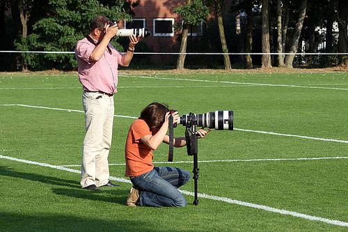
7 What if you are very far away (RS satellites in LEO are km) and you want to see lots of detail in the scene? What about a telephoto (long focal length) lens?

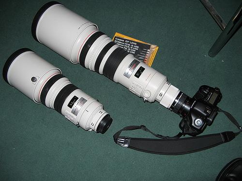
8 Canon EF 500mm F/4
9
10
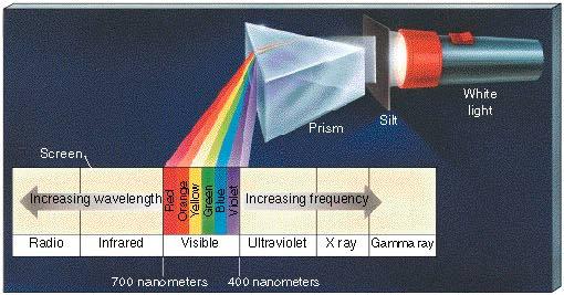
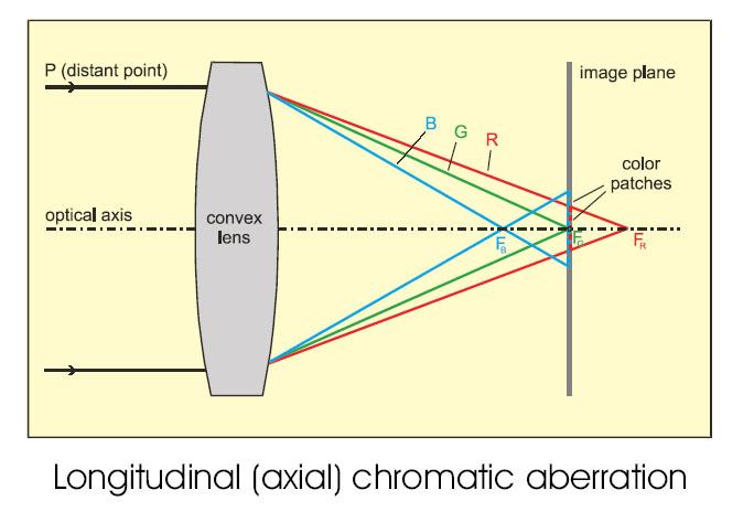
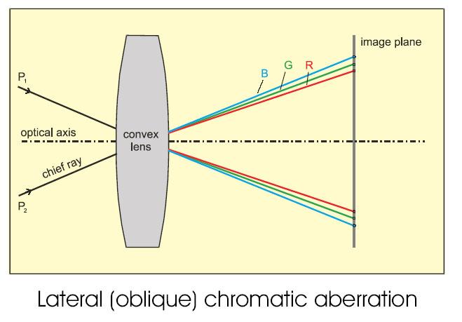
11 For a RS camera, there are two big problems with this approach. Speed / Aperture / Weight, need small f# (f/d). f fixed by scale requirements, therefore diameter must be large. Glass is heavy. Satellite payloads must minimize weight. Chromatic Aberration, refractive elements (lenses) affect different wavelengths differently. Produces color fringes. Reflective elements (mirrors) do not. In addition, RS cameras usually have RGBI not just RGB channels, that makes it even worse.
12
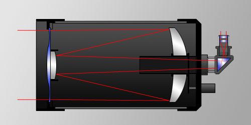
13
14
15 Some examples of chromatic aberration

16 Chromatic aberration from poor quality optics

17 Image obtained from test pattern

18 Note the famous purple fringe around the zoomed in images of the bright lights


19 Again, note the purple fringes around the bright patches in the zoomed in view


20 Refractive versus reflective optical elements
21 Schmidt-Cassegrain Telescope
22 Another advantage of reflective optical elements folded light path allows long focal length within a package that is much shorter

23 Scmidt-Cassegrain 500 mm optics for handheld camera compare size and bulk to earlier shown lens
 and do the focusing, like a lens. There can be more than 2 elements.")
24 Focal plane with linear array CCD detector Primary mirror (diameter determines the aperture size) Secondary mirror, with support vanes Cassegrain Telescope Typical layout of linear sensor based telescope camera used for remote sensing from space. Primary and secondary mirrors are powered (curved) and do the focusing, like a lens. There can be more than 2 elements. Sometimes there are flat mirrors to just fold the optical path for a needed long focal length. Area CCD arrays are not big enough for practical use. Dimension of linear array determines image width and cross-track GSD, orbit motion or body scanning plus sampling in time produce the image length, and determine the along-track GSD (usually these two GSD s are approximately the same) Parallel rays enter the aperture from terrestrial scenes

25 Worldview 1 Primary Mirror from the back, note material removal to reduce mass

26 Hubble backup mirror made by kodak, this one did not have defects as did the one from Perkin Elmer

27 Geoeye 1 Primary Mirror


28 Satellite camera resembles an astronomical telescope more than the conventional notion of a camera

29 Schematic of IKONOS camera Camera made by Kodak Cassegrain (Korsch TMA) telescope 10 meter focal length 12 micrometer detector size TDI: stages 11 bit quantization with APCM compression Aperture size 0.7m +/- 30 degree pointing 13,500 panchromatic pixels (1m), 3375 multispectral pixels (4m) 6500 lines / second km swath width at 680km alt.

30 Kodak Model 1000TM commercial version of the IKONOS camera Reduced size and mass for fitting into mini-satellites ~$ 1M ~ 2 year delivery time

31 Off-axis design to eliminate the obstruction of the secondary mirror, from Jena Optik Rapideye

32 Worldview 1 also has Off-axis TMA design for unobstructed aperture

33 IKONOS focal plane with mechanically displaced linear arrays to simulate 13,500 length, panchromatic, RGB, and near infrared
34 Emulate a continuous 40-pixel linear array with 3 16-pixel arrays, align left-right and displace by integer number of pixel dimensions Integer number of line widths Displacement in the focal plane for nadir scanning between linear array segments. V gs is the ground velocity of the viewpoint. n is any integer, for off nadir scanning, may adjust timing.
35 Quickbird Focal Plane Layout

36 Schematic of auxiliary components for the IKONOS sensor


37 IKONOS Space Imaging (GSD=0.82m)
 Orbview 3 -Orbimage Space")

38 GeoEye 1 - GeoEye (GSD=0.46m) Orbview 3 -Orbimage Space Imaging + Orbimage = GeoEye Digital Globe + GeoEye = Digital Globe

39 Quickbird Spacecraft and camera yielding 0.65m panchromatic imagery (operated by Digital Globe)

40 Worldview 2 - Digital Globe (GSD=0.46m)

41 Worldview 3 Digital Globe (GSD=0.31m)
42 Size Comparison Satellite Camera 2m Aerial Camera 1m Handheld Camera 0m
Satellite/Aircraft Imaging Systems Imaging Sensors Standard scanner designs Image data formats
 CEE 6150: Digital Image Processing 1 Satellite/Aircraft Imaging Systems Imaging Sensors Standard scanner designs Image data formats CEE 6150: Digital Image Processing 2 CEE 6150: Digital Image Processing
US Commercial Imaging Satellites
 US Commercial Imaging Satellites In the early 1990s, Russia began selling 2-meter resolution product from its archives of collected spy satellite imagery. Some of this product was down-sampled to provide
Remote Sensing Platforms
 Types of Platforms Lighter-than-air Remote Sensing Platforms Free floating balloons Restricted by atmospheric conditions Used to acquire meteorological/atmospheric data Blimps/dirigibles Major role - news
Philpot & Philipson: Remote Sensing Fundamentals Scanners 8.1 W.D. Philpot, Cornell University, Fall 2015
 Philpot & Philipson: Remote Sensing Fundamentals Scanners 8.1 8. SCANNERS 8.1 General Scanners are scanning radiometers which, when operated from an airborne or spaceborne platform, image the terrain in
Compact Dual Field-of-View Telescope for Small Satellite Payloads
 Compact Dual Field-of-View Telescope for Small Satellite Payloads James C. Peterson Space Dynamics Laboratory 1695 North Research Park Way, North Logan, UT 84341; 435-797-4624 Jim.Peterson@sdl.usu.edu
Chapters 1-3. Chapter 1: Introduction and applications of photogrammetry Chapter 2: Electro-magnetic radiation. Chapter 3: Basic optics
 Chapters 1-3 Chapter 1: Introduction and applications of photogrammetry Chapter 2: Electro-magnetic radiation Radiation sources Classification of remote sensing systems (passive & active) Electromagnetic
Chapter 25 Optical Instruments
 Chapter 25 Optical Instruments Units of Chapter 25 Cameras, Film, and Digital The Human Eye; Corrective Lenses Magnifying Glass Telescopes Compound Microscope Aberrations of Lenses and Mirrors Limits of
Chapters 1-3. Chapter 1: Introduction and applications of photogrammetry Chapter 2: Electro-magnetic radiation. Chapter 3: Basic optics
 Chapters 1-3 Chapter 1: Introduction and applications of photogrammetry Chapter 2: Electro-magnetic radiation Radiation sources Classification of remote sensing systems (passive & active) Electromagnetic
A 1m Resolution Camera For Small Satellites
 A 1m Resolution Camera For Small Satellites Paper SSC06-X-5 Presenter: Jeremy Curtis 1 Introduction TopSat launched October 2005 carrying RAL s 2.5m GSD camera into a 686km orbit Built and operated by
LECTURE NOTES 2016 CONTENTS. Sensors and Platforms for Acquisition of Aerial and Satellite Image Data
 LECTURE NOTES 2016 Prof. John TRINDER School of Civil and Environmental Engineering Telephone: (02) 9 385 5020 Fax: (02) 9 313 7493 j.trinder@unsw.edu.au CONTENTS Chapter 1 Chapter 2 Sensors and Platforms
INSTRUMENT DESIGN FOR THE PEGASUS HALE UAV PAYLOAD T. Van Achteren, B. Delauré, J. Everaerts
 INSTRUMENT DESIGN FOR THE PEGASUS HALE UAV PAYLOAD T. Van Achteren, B. Delauré, J. Everaerts Flemish Institute for Technological Research (VITO) Centre for Remote Sensing and Earth Observation (TAP) Boeretang
HIGH RESOLUTION IMAGERY FOR MAPPING AND LANDSCAPE MONITORING
 HIGH RESOLUTION IMAGERY FOR MAPPING AND LANDSCAPE MONITORING Karsten Jacobsen Leibniz University Hannover, Institute of Photogrammetry and Geoinformation Nienburger Str. 1, 30165 Hannover, Germany, jacobsen@ipi.uni-hannover.de
Remote Sensing Platforms
 Remote Sensing Platforms Remote Sensing Platforms - Introduction Allow observer and/or sensor to be above the target/phenomena of interest Two primary categories Aircraft Spacecraft Each type offers different
Chapters 1 & 2. Definitions and applications Conceptual basis of photogrammetric processing
 Chapters 1 & 2 Chapter 1: Photogrammetry Definitions and applications Conceptual basis of photogrammetric processing Transition from two-dimensional imagery to three-dimensional information Automation
COURSE NAME: PHOTOGRAPHY AND AUDIO VISUAL PRODUCTION (VOCATIONAL) FOR UNDER GRADUATE (FIRST YEAR)
 FOR UNDER GRADUATE (FIRST YEAR)") COURSE NAME: PHOTOGRAPHY AND AUDIO VISUAL PRODUCTION (VOCATIONAL) FOR UNDER GRADUATE (FIRST YEAR) PAPER TITLE: BASIC PHOTOGRAPHIC UNIT - 3 : SIMPLE LENS TOPIC: LENS PROPERTIES AND DEFECTS OBJECTIVES By
COURSE NAME: PHOTOGRAPHY AND AUDIO VISUAL PRODUCTION (VOCATIONAL) FOR UNDER GRADUATE (FIRST YEAR) PAPER TITLE: BASIC PHOTOGRAPHIC UNIT - 3 : SIMPLE LENS TOPIC: LENS PROPERTIES AND DEFECTS OBJECTIVES By
RECENT DEVELOPMENTS OF DIGITAL CAMERAS AND SPACE IMAGERY. Karsten JACOBSEN
 RECENT DEVELOPMENTS OF DIGITAL CAMERAS AND SPACE IMAGERY Abstract Karsten JACOBSEN Leibniz University Hannover, Institute of Photogrammetry and Geoinformation, Nienburger Str. 1, D-30167 Hannover, Germany
Leica ADS80 - Digital Airborne Imaging Solution NAIP, Salt Lake City 4 December 2008
 Luzern, Switzerland, acquired at 5 cm GSD, 2008. Leica ADS80 - Digital Airborne Imaging Solution NAIP, Salt Lake City 4 December 2008 Shawn Slade, Doug Flint and Ruedi Wagner Leica Geosystems AG, Airborne
Reflectors vs. Refractors
 1 Telescope Types - Telescopes collect and concentrate light (which can then be magnified, dispersed as a spectrum, etc). - In the end it is the collecting area that counts. - There are two primary telescope
Physics 1230 Homework 8 Due Friday June 24, 2016
 At this point, you know lots about mirrors and lenses and can predict how they interact with light from objects to form images for observers. In the next part of the course, we consider applications of
Building a Real Camera. Slides Credit: Svetlana Lazebnik
 Building a Real Camera Slides Credit: Svetlana Lazebnik Home-made pinhole camera Slide by A. Efros http://www.debevec.org/pinhole/ Shrinking the aperture Why not make the aperture as small as possible?
Two Fundamental Properties of a Telescope
 Two Fundamental Properties of a Telescope 1. Angular Resolution smallest angle which can be seen = 1.22 / D 2. Light-Collecting Area The telescope is a photon bucket A = (D/2)2 D A Parts of the Human Eye
Lecture PowerPoint. Chapter 25 Physics: Principles with Applications, 6 th edition Giancoli
 Lecture PowerPoint Chapter 25 Physics: Principles with Applications, 6 th edition Giancoli 2005 Pearson Prentice Hall This work is protected by United States copyright laws and is provided solely for the
Waves & Oscillations
 Physics 42200 Waves & Oscillations Lecture 33 Geometric Optics Spring 2013 Semester Matthew Jones Aberrations We have continued to make approximations: Paraxial rays Spherical lenses Index of refraction
Digital Aerial Photography UNBC March 22, Presented by: Dick Mynen TDB Consultants Inc.
 Digital Aerial Photography UNBC March 22, 2011 Presented by: Dick Mynen TDB Consultants Inc. Airborne Large Scale Digital Photography Who is using the technology in today s environment Options available
IKONOS High Resolution Multispectral Scanner Sensor Characteristics
 High Spatial Resolution and Hyperspectral Scanners IKONOS High Resolution Multispectral Scanner Sensor Characteristics Launch Date View Angle Orbit 24 September 1999 Vandenberg Air Force Base, California,
Introduction to Remote Sensing
 Introduction to Remote Sensing Spatial, spectral, temporal resolutions Image display alternatives Vegetation Indices Image classifications Image change detections Accuracy assessment Satellites & Air-Photos
Feasibility and Design for the Simplex Electronic Telescope. Brian Dodson
 Feasibility and Design for the Simplex Electronic Telescope Brian Dodson Charge: A feasibility check and design hints are wanted for the proposed Simplex Electronic Telescope (SET). The telescope is based
Int n r t o r d o u d c u ti t on o n to t o Remote Sensing
 Introduction to Remote Sensing Definition of Remote Sensing Remote sensing refers to the activities of recording/observing/perceiving(sensing)objects or events at far away (remote) places. In remote sensing,
CHARACTERISTICS OF REMOTELY SENSED IMAGERY. Spatial Resolution
 CHARACTERISTICS OF REMOTELY SENSED IMAGERY Spatial Resolution There are a number of ways in which images can differ. One set of important differences relate to the various resolutions that images express.
25 cm. 60 cm. 50 cm. 40 cm.
 Geometrical Optics 7. The image formed by a plane mirror is: (a) Real. (b) Virtual. (c) Erect and of equal size. (d) Laterally inverted. (e) B, c, and d. (f) A, b and c. 8. A real image is that: (a) Which
Remote Sensing of the Environment An Earth Resource Perspective John R. Jensen Second Edition
 Remote Sensing of the Environment An Earth Resource Perspective John R. Jensen Second Edition Pearson Education Limited Edinburgh Gate Harlow Essex CM20 2JE England and Associated Companies throughout
Mapping Cameras. Chapter Three Introduction
 Chapter Three Mapping Cameras 3.1. Introduction This chapter introduces sensors used for acquiring aerial photographs. Although cameras are the oldest form of remote sensing instrument, they have changed
Image Fusion. Pan Sharpening. Pan Sharpening. Pan Sharpening: ENVI. Multi-spectral and PAN. Magsud Mehdiyev Geoinfomatics Center, AIT
 1 Image Fusion Sensor Merging Magsud Mehdiyev Geoinfomatics Center, AIT Image Fusion is a combination of two or more different images to form a new image by using certain algorithms. ( Pohl et al 1998)
HIGH RESOLUTION COLOR IMAGERY FOR ORTHOMAPS AND REMOTE SENSING. Author: Peter Fricker Director Product Management Image Sensors
 HIGH RESOLUTION COLOR IMAGERY FOR ORTHOMAPS AND REMOTE SENSING Author: Peter Fricker Director Product Management Image Sensors Co-Author: Tauno Saks Product Manager Airborne Data Acquisition Leica Geosystems
CXCI. Optical design of a compact telescope for the next generation Earth Observation system CXCI. Vincent COSTES. Octobre 2012
 CXCI Optical design of a compact telescope for the next generation Earth Observation system Vincent COSTES Octobre 2012 CXCI CXCI SUMMARY INTRODUCTION CXCI TECHNOLOGICAL PROGRAM COMPACTNESS REQUIREMENT
The studies began when the Tiros satellites (1960) provided man s first synoptic view of the Earth s weather systems.
 provided man s first synoptic view of the Earth s weather systems.") Remote sensing of the Earth from orbital altitudes was recognized in the mid-1960 s as a potential technique for obtaining information important for the effective use and conservation of natural resources.
Remote sensing of the Earth from orbital altitudes was recognized in the mid-1960 s as a potential technique for obtaining information important for the effective use and conservation of natural resources.
Building a Real Camera
 Building a Real Camera Home-made pinhole camera Slide by A. Efros http://www.debevec.org/pinhole/ Shrinking the aperture Why not make the aperture as small as possible? Less light gets through Diffraction
Abstract Quickbird Vs Aerial photos in identifying man-made objects
 Abstract Quickbird Vs Aerial s in identifying man-made objects Abdullah Mah abdullah.mah@aramco.com Remote Sensing Group, emap Division Integrated Solutions Services Department (ISSD) Saudi Aramco, Dhahran
CALIBRATION OF OPTICAL SATELLITE SENSORS
 CALIBRATION OF OPTICAL SATELLITE SENSORS KARSTEN JACOBSEN University of Hannover Institute of Photogrammetry and Geoinformation Nienburger Str. 1, D-30167 Hannover, Germany jacobsen@ipi.uni-hannover.de
Telescopes and their configurations. Quick review at the GO level
 Telescopes and their configurations Quick review at the GO level Refraction & Reflection Light travels slower in denser material Speed depends on wavelength Image Formation real Focal Length (f) : Distance
CALIBRATION OF IMAGING SATELLITE SENSORS
 CALIBRATION OF IMAGING SATELLITE SENSORS Jacobsen, K. Institute of Photogrammetry and GeoInformation, University of Hannover jacobsen@ipi.uni-hannover.de KEY WORDS: imaging satellites, geometry, calibration
Why is There a Black Dot when Defocus = 1λ?
 Why is There a Black Dot when Defocus = 1λ? W = W 020 = a 020 ρ 2 When a 020 = 1λ Sag of the wavefront at full aperture (ρ = 1) = 1λ Sag of the wavefront at ρ = 0.707 = 0.5λ Area of the pupil from ρ =
Cameras. CSE 455, Winter 2010 January 25, 2010
 Cameras CSE 455, Winter 2010 January 25, 2010 Announcements New Lecturer! Neel Joshi, Ph.D. Post-Doctoral Researcher Microsoft Research neel@cs Project 1b (seam carving) was due on Friday the 22 nd Project
WorldView-2. WorldView-2 Overview
 WorldView-2 WorldView-2 Overview 6/4/09 DigitalGlobe Proprietary 1 Most Advanced Satellite Constellation Finest available resolution showing crisp detail Greatest collection capacity Highest geolocation
Geometry of Aerial Photographs
 Geometry of Aerial Photographs Aerial Cameras Aerial cameras must be (details in lectures): Geometrically stable Have fast and efficient shutters Have high geometric and optical quality lenses They can
BAFFLES DESIGN OF THE PROBA-V WIDE FOV TMA
 BAFFLES DESIGN OF THE PROBA-V WIDE FOV TMA A. Mazzoli 1, P. Holbrouck 2, Y. Houbrechts 1, L. Maresi 3, Y. Stockman 1, M.Taccola 3, J. Versluys 2. 1 Centre Spatial de Liège (CSL), University of Liège, Avenue
An Introduction to Geomatics. Prepared by: Dr. Maher A. El-Hallaq خاص بطلبة مساق مقدمة في علم. Associate Professor of Surveying IUG
 An Introduction to Geomatics خاص بطلبة مساق مقدمة في علم الجيوماتكس Prepared by: Dr. Maher A. El-Hallaq Associate Professor of Surveying IUG 1 Airborne Imagery Dr. Maher A. El-Hallaq Associate Professor
Vladimir Vassiliev UCLA
 Vladimir Vassiliev UCLA Reduce cost of FP instrumentation (small plate scale) Improve imaging quality (angular resolution) Minimize isochronous distortion (energy threshold, +) Increase FoV (sky survey,
REMOTE SENSING INTERPRETATION
 REMOTE SENSING INTERPRETATION Jan Clevers Centre for Geo-Information - WU Remote Sensing --> RS Sensor at a distance EARTH OBSERVATION EM energy Earth RS is a tool; one of the sources of information! 1
Applications of Optics
 Nicholas J. Giordano www.cengage.com/physics/giordano Chapter 26 Applications of Optics Marilyn Akins, PhD Broome Community College Applications of Optics Many devices are based on the principles of optics
CHARACTERISTICS OF VERY HIGH RESOLUTION OPTICAL SATELLITES FOR TOPOGRAPHIC MAPPING
 CHARACTERISTICS OF VERY HIGH RESOLUTION OPTICAL SATELLITES FOR TOPOGRAPHIC MAPPING K. Jacobsen Leibniz University Hannover, Institute of Photogrammetry and Geoinformation jacobsen@ipi.uni-hannover.de Commission
Utilizing Commercial DSLR for High Resolution Earth Observation Satellite
 SSC18-XII-03 Utilizing Commercial DSLR for High Resolution Earth Observation Satellite Nobutada Sako Canon Electronics Inc. 3-5-10, Shibakoen, Minato-ku, Tokyo 105-0011, Japan; +81-3-6910-1105 sako.nobutada@canon-elec.co.jp
Optical Components for Laser Applications. Günter Toesko - Laserseminar BLZ im Dezember
 Günter Toesko - Laserseminar BLZ im Dezember 2009 1 Aberrations An optical aberration is a distortion in the image formed by an optical system compared to the original. It can arise for a number of reasons
PLANET IMAGERY PRODUCT SPECIFICATIONS PLANET.COM
 PLANET IMAGERY PRODUCT SPECIFICATIONS SUPPORT@PLANET.COM PLANET.COM LAST UPDATED JANUARY 2018 TABLE OF CONTENTS LIST OF FIGURES 3 LIST OF TABLES 4 GLOSSARY 5 1. OVERVIEW OF DOCUMENT 7 1.1 Company Overview
Tutorial 10 Information extraction from high resolution optical satellite sensors
 Tutorial 10 Information extraction from high resolution optical satellite sensors Karsten Jacobsen 1, Emmanuel Baltsavias 2, David Holland 3 1 University of, ienburger Strasse 1, D-30167, Germany, jacobsen@ipi.uni-hannover.de
10/25/2017. Light and Telescope. Reflector - Mirror. Refractor - Lens. PHYS 1411 Introduction to Astronomy. Topics for Today s class
 PHYS 1411 Introduction to Astronomy Light and Telescope Chapter 6 Reminders Homework on Chapter 4, 5 and 6 due November 1 st. No extensions. Lab 8 handout is on class web page. Due Week of November 27
Phys 2310 Mon. Oct. 16, 2017 Today s Topics. Finish Chapter 34: Geometric Optics Homework this Week
 Phys 2310 Mon. Oct. 16, 2017 Today s Topics Finish Chapter 34: Geometric Optics Homework this Week 1 Homework this Week (HW #10) Homework this week due Mon., Oct. 23: Chapter 34: #47, 57, 59, 60, 61, 62,
There is a range of distances over which objects will be in focus; this is called the depth of field of the lens. Objects closer or farther are
 Chapter 25 Optical Instruments Some Topics in Chapter 25 Cameras The Human Eye; Corrective Lenses Magnifying Glass Telescopes Compound Microscope Aberrations of Lenses and Mirrors Limits of Resolution
Classical Optical Solutions
 Petzval Lens Enter Petzval, a Hungarian mathematician. To pursue a prize being offered for the development of a wide-field fast lens system he enlisted Hungarian army members seeing a distraction from
LE/ESSE Payload Design
 LE/ESSE4360 - Payload Design 3.2 Spacecraft Sensors Introduction to Sensors Earth, Moon, Mars, and Beyond Dr. Jinjun Shan, Professor of Space Engineering Department of Earth and Space Science and Engineering
Potential benefits of freeform optics for the ELT instruments. J. Kosmalski
 Potential benefits of freeform optics for the ELT instruments J. Kosmalski Freeform Days, 12-13 th October 2017 Summary Introduction to E-ELT intruments Freeform design for MAORY LGS Free form design for
CH. 23 Mirrors and Lenses HW# 6, 7, 9, 11, 13, 21, 25, 31, 33, 35
 CH. 23 Mirrors and Lenses HW# 6, 7, 9, 11, 13, 21, 25, 31, 33, 35 Mirrors Rays of light reflect off of mirrors, and where the reflected rays either intersect or appear to originate from, will be the location
Airborne or Spaceborne Images for Topographic Mapping?
 Advances in Geosciences Konstantinos Perakis, Editor EARSeL, 2012 Airborne or Spaceborne Images for Topographic Mapping? Karsten Jacobsen Leibniz University Hannover, Institute of Photogrammetry and Geoinformation,
High Resolution Satellite Data for Forest Management. - Algorithm for Tree Counting -
 High Resolution Satellite Data for Forest Management - Algorithm for Tree Counting - Kiyoshi HONDA ACRoRS, Asian Institute of Technology NASDA ALOS (NASDA JAPAN) 2.5m Resolution Launch in 2002 Panchromatic
Converging and Diverging Surfaces. Lenses. Converging Surface
 Lenses Sandy Skoglund 2 Converging and Diverging s AIR Converging If the surface is convex, it is a converging surface in the sense that the parallel rays bend toward each other after passing through the
The New Rig Camera Process in TNTmips Pro 2018
 The New Rig Camera Process in TNTmips Pro 2018 Jack Paris, Ph.D. Paris Geospatial, LLC, 3017 Park Ave., Clovis, CA 93611, 559-291-2796, jparis37@msn.com Kinds of Digital Cameras for Drones Two kinds of
RECONNAISSANCE PAYLOADS FOR RESPONSIVE SPACE
 3rd Responsive Space Conference RS3-2005-5004 RECONNAISSANCE PAYLOADS FOR RESPONSIVE SPACE Charles Cox Stanley Kishner Richard Whittlesey Goodrich Optical and Space Systems Division Danbury, CT Frederick
Hyperspectral Imager for Coastal Ocean (HICO)
") Hyperspectral Imager for Coastal Ocean (HICO) Detlev Even 733 Bishop Street, Suite 2800 phone: (808) 441-3610 fax: (808) 441-3601 email: detlev@nova-sol.com Arleen Velasco 15150 Avenue of Science phone:
Hyperspectral Imager for Coastal Ocean (HICO) Detlev Even 733 Bishop Street, Suite 2800 phone: (808) 441-3610 fax: (808) 441-3601 email: detlev@nova-sol.com Arleen Velasco 15150 Avenue of Science phone:
LPIS Orthoimagery An assessment of the Bing imagery for LPIS purpose
 LPIS Orthoimagery An assessment of the Bing imagery for LPIS purpose Slavko Lemajić Wim Devos, Pavel Milenov GeoCAP Action - MARS Unit - JRC Ispra Tallinn, 24 th November 2011 Outline JRC`s Ortho specifications
Geometrical Optics Optical systems
 Phys 322 Lecture 16 Chapter 5 Geometrical Optics Optical systems Magnifying glass Purpose: enlarge a nearby object by increasing its image size on retina Requirements: Image should not be inverted Image
1.6 Beam Wander vs. Image Jitter
 8 Chapter 1 1.6 Beam Wander vs. Image Jitter It is common at this point to look at beam wander and image jitter and ask what differentiates them. Consider a cooperative optical communication system that
Phase One 190MP Aerial System
 White Paper Phase One 190MP Aerial System Introduction Phase One Industrial s 100MP medium format aerial camera systems have earned a worldwide reputation for its high performance. They are commonly used
Lecture 22: Cameras & Lenses III. Computer Graphics and Imaging UC Berkeley CS184/284A, Spring 2017
 Lecture 22: Cameras & Lenses III Computer Graphics and Imaging UC Berkeley, Spring 2017 F-Number For Lens vs. Photo A lens s F-Number is the maximum for that lens E.g. 50 mm F/1.4 is a high-quality telephoto
Chapter 18 Optical Elements
 Chapter 18 Optical Elements GOALS When you have mastered the content of this chapter, you will be able to achieve the following goals: Definitions Define each of the following terms and use it in an operational
CubeSat-Scale Hyperspectral Imager for Middle Atmosphere Investigations
 CubeSat-Scale Hyperspectral Imager for Middle Atmosphere Investigations Rick Doe 1, Steve Watchorn 2, John Noto 2, Robert Kerr 2, Karl van Dyk 1, Kyle Leveque 1, and Christopher Sioris 3 1 SRI International
REMOTE SENSING. Topic 10 Fundamentals of Digital Multispectral Remote Sensing MULTISPECTRAL SCANNERS MULTISPECTRAL SCANNERS
 REMOTE SENSING Topic 10 Fundamentals of Digital Multispectral Remote Sensing Chapter 5: Lillesand and Keifer Chapter 6: Avery and Berlin MULTISPECTRAL SCANNERS Record EMR in a number of discrete portions
IMAGE SENSOR SOLUTIONS. KAC-96-1/5" Lens Kit. KODAK KAC-96-1/5" Lens Kit. for use with the KODAK CMOS Image Sensors. November 2004 Revision 2
 KODAK for use with the KODAK CMOS Image Sensors November 2004 Revision 2 1.1 Introduction Choosing the right lens is a critical aspect of designing an imaging system. Typically the trade off between image
Some Basic Concepts of Remote Sensing. Lecture 2 August 31, 2005
 Some Basic Concepts of Remote Sensing Lecture 2 August 31, 2005 What is remote sensing Remote Sensing: remote sensing is science of acquiring, processing, and interpreting images and related data that
Lecture 6: Multispectral Earth Resource Satellites. The University at Albany Fall 2018 Geography and Planning
 Lecture 6: Multispectral Earth Resource Satellites The University at Albany Fall 2018 Geography and Planning Outline SPOT program and other moderate resolution systems High resolution satellite systems
NON-PHOTOGRAPHIC SYSTEMS: Multispectral Scanners Medium and coarse resolution sensor comparisons: Landsat, SPOT, AVHRR and MODIS
 NON-PHOTOGRAPHIC SYSTEMS: Multispectral Scanners Medium and coarse resolution sensor comparisons: Landsat, SPOT, AVHRR and MODIS CLASSIFICATION OF NONPHOTOGRAPHIC REMOTE SENSORS PASSIVE ACTIVE DIGITAL
Nikon Capture NX "How To..." Series
 1 of 5 5/15/2007 1:34 PM Nikon Capture NX "How To..." Series Article 18: How to reduce the effects of Chromatic Aberration. Purpose: The "Color Aberration Tool" in Capture NX may be used to reduce or eliminate
Hyperspectral Sensor
 Hyperspectral Sensor Detlev Even 733 Bishop Street, Suite 2800 Honolulu, HI 96813 phone: (808) 441-3610 fax: (808) 441-3601 email: detlev@nova-sol.com Arleen Velasco 15150 Avenue of Science San Diego,
Compact High Resolution Imaging Spectrometer (CHRIS) siraelectro-optics
 siraelectro-optics") Compact High Resolution Imaging Spectrometer (CHRIS) Mike Cutter (Mike_Cutter@siraeo.co.uk) Summary CHRIS Instrument Design Instrument Specification & Performance Operating Modes Calibration Plan Data
Compact High Resolution Imaging Spectrometer (CHRIS) Mike Cutter (Mike_Cutter@siraeo.co.uk) Summary CHRIS Instrument Design Instrument Specification & Performance Operating Modes Calibration Plan Data
Congress Best Paper Award
 Congress Best Paper Award Preprints of the 3rd IFAC Conference on Mechatronic Systems - Mechatronics 2004, 6-8 September 2004, Sydney, Australia, pp.547-552. OPTO-MECHATRONIC IMAE STABILIZATION FOR A COMPACT
Binocular and Scope Performance 57. Diffraction Effects
 Binocular and Scope Performance 57 Diffraction Effects The resolving power of a perfect optical system is determined by diffraction that results from the wave nature of light. An infinitely distant point
PHY385H1F Introductory Optics. Practicals Session 7 Studying for Test 2
 PHY385H1F Introductory Optics Practicals Session 7 Studying for Test 2 Entrance Pupil & Exit Pupil A Cooke-triplet consists of three thin lenses in succession, and is often used in cameras. It was patented
LENSES. INEL 6088 Computer Vision
 LENSES INEL 6088 Computer Vision Digital camera A digital camera replaces film with a sensor array Each cell in the array is a Charge Coupled Device light-sensitive diode that converts photons to electrons
The Optics of Mirrors
 Use with Text Pages 558 563 The Optics of Mirrors Use the terms in the list below to fill in the blanks in the paragraphs about mirrors. reversed smooth eyes concave focal smaller reflect behind ray convex
OPAL Optical Profiling of the Atmospheric Limb
 OPAL Optical Profiling of the Atmospheric Limb Alan Marchant Chad Fish Erik Stromberg Charles Swenson Jim Peterson OPAL STEADE Mission Storm Time Energy & Dynamics Explorers NASA Mission of Opportunity
Calibration Report. Short Version. UltraCam L, S/N UC-L Vexcel Imaging GmbH, A-8010 Graz, Austria
 Calibration Report Short Version Camera: Manufacturer: UltraCam L, S/N UC-L-1-00612089 Vexcel Imaging GmbH, A-8010 Graz, Austria Date of Calibration: Mar-23-2010 Date of Report: May-17-2010 Camera Revision:
Computer Vision. The Pinhole Camera Model
 Computer Vision The Pinhole Camera Model Filippo Bergamasco (filippo.bergamasco@unive.it) http://www.dais.unive.it/~bergamasco DAIS, Ca Foscari University of Venice Academic year 2017/2018 Imaging device
The Imaging Chain in Optical Astronomy
 The Imaging Chain in Optical Astronomy Review and Overview Imaging Chain includes these elements: 1. energy source 2. object 3. collector 4. detector (or sensor) 5. processor 6. display 7. analysis 8.
The Imaging Chain in Optical Astronomy
 The Imaging Chain in Optical Astronomy 1 Review and Overview Imaging Chain includes these elements: 1. energy source 2. object 3. collector 4. detector (or sensor) 5. processor 6. display 7. analysis 8.
Ground Control Configuration Analysis for Small Area UAV Imagery Based Mapping
 Ground Control Configuration Analysis for Small Area UAV Imagery Based Mapping ASPRS IGTF 2017, Baltimore, MD March 15 th, 2017 Presenter: David Day, CP, GISP Wes Weaver Keystone Aerial Surveys, Inc. Summary
Topographic mapping from space K. Jacobsen*, G. Büyüksalih**
 Topographic mapping from space K. Jacobsen*, G. Büyüksalih** * Institute of Photogrammetry and Geoinformation, Leibniz University Hannover ** BIMTAS, Altunizade-Istanbul, Turkey KEYWORDS: WorldView-1,
Rochester Institute of Technology. Wildfire Airborne Sensor Program (WASP) Project Overview
 Project Overview") Rochester Institute of Technology Wildfire Airborne Sensor Program (WASP) Project Overview Introduction The following slides describe a program underway at RIT The sensor system described herein is being
Rochester Institute of Technology Wildfire Airborne Sensor Program (WASP) Project Overview Introduction The following slides describe a program underway at RIT The sensor system described herein is being
Better Imaging with a Schmidt-Czerny-Turner Spectrograph
 Better Imaging with a Schmidt-Czerny-Turner Spectrograph Abstract For years, images have been measured using Czerny-Turner (CT) design dispersive spectrographs. Optical aberrations inherent in the CT design
Chapter 23. Mirrors and Lenses
 Chapter 23 Mirrors and Lenses Mirrors and Lenses The development of mirrors and lenses aided the progress of science. It led to the microscopes and telescopes. Allowed the study of objects from microbes
Photogrammetry. Lecture 4 September 7, 2005
 Photogrammetry Lecture 4 September 7, 2005 What is Photogrammetry Photogrammetry is the art and science of making accurate measurements by means of aerial photography: Analog photogrammetry (using films:
IMAGE FORMATION. Light source properties. Sensor characteristics Surface. Surface reflectance properties. Optics
 IMAGE FORMATION Light source properties Sensor characteristics Surface Exposure shape Optics Surface reflectance properties ANALOG IMAGES An image can be understood as a 2D light intensity function f(x,y)