Crop and Irrigation Water Management Using High-resolution Airborne Remote Sensing
|
|
|
- Dustin Walton
- 6 years ago
- Views:
Transcription
1 Crop and Irrigation Water Management Using High-resolution Airborne Remote Sensing Christopher M. U. Neale and Hari Jayanthi Dept. of Biological and Irrigation Eng. Utah State University & James L.Wright USDA-ARS, Kimberly, Idaho
2 Remote Sensing of Crop Evapotranspiration Three basic approaches are being developed 1) Energy balance approach: Ground meteorological data and remotely sensed inputs in the shortwave and longwave bands are used to obtain parameters for estimating Rn, G and H => Energy balance equation obtain instantaneous latent heat fluxes (LE) that are extrapolated for the entire day and over time between satellite overpasses or airborne image acquisition flights
3 Remote Sensing of Crop Evapotranspiration 2) Reflectance-based crop coefficient approach: Remotely sensed inputs in the shortwave along with reference ET from ground meteorological stations are used to obtain daily actual crop ET in each field Interpolation over time between satellite or airborne images 3) Process models (SVAT models) that use RS for some input variables
4 Crop and Water Management Outline of Presentation Show how ground-based and airborne high resolution remotely sensed data can be used to develop and verify ET and yield models (precision agriculture perspective) Short description of the USU airborne multispectral digital remote sensing system Show recently developed Kcr for new crops Examples of applications at field and irrigation command area scales
5 Crop Coefficients Wright (1982) introduced the concept of basalcrop coefficients (Kcb): Kc = Kcb * Ka + Ks Where Ka and Ks are adjustments for limiting water in the root zone and wet soil surface respectively Allen et al (1998) FAO 56 presented crop coefficients for several crops
6 Reflectance-based Crop Coefficients Jackson et al. (1980), later Heilman et al. (1982) showed similarities with a ratio of the perpendicular vegetation index (PVI) with crop coefficient of wheat and alfalfa. Bausch and Neale (1987) and Neale et al. (1989) developed reflectance-based crop coefficients for corn using the Normalized Difference Vegetation Index (NDVI) from the TM bands Bausch (1993 and 1995) proposed the Soil Adjusted Vegetation Index (SAVI) instead of NDVI for the reflectance-based crop coefficient for corn Neale et al (1996) developed reflectance-based crop coefficients for cotton
7 Development of Reflectance-based Crop Coefficients: Rationale for Site Selection Kimberly, Idaho Was an area planted with the target crops of potato, sugar beets and beans Same agro-climatic region where Wright (1982) developed the basal crop curves with measured actual crop ET using lysimeters Wright (1982) conducted extensive crop biophysical parameter measurements which we used to relate the ET measurements to our remotely sensed data (Leaf area index, plant height, plant cover)
8 Approach: Development and Verification at Different Scales Small field scales: Ground-based radiometry and soil-moisture measurements Larger fields: Airborne imagery, flux measurements with Bowen Ratio and Eddy Covariance systems and soil moisture measurements Irrigation command areas and irrigation system scales: Airborne or satellite imagery, flux measurements and water balance (requiring inflow and outflow irrigation water measurements)
9 Source of Remotely Sensed Data EXOTECH 4-band radiometer with Thematic Mapper Bands TM1 4 => Canopy reflectance obtained with barium sulphate standard reflectance panel with know bidirectional properties High-resolution multispectral imagery from the USU airborne system with pixel resolution varying from 0.20 to 2.5 meters
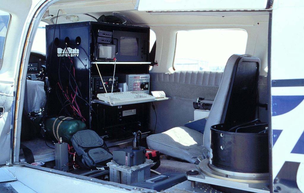
10 Description of the USU Airborne Multispectral Digital System 3 Kodak Megaplus 4.2i digital frame cameras with Nikon lenses contain narrow band interference filters in the green (0.55 µm), red (0.67 µm) and near- infrared (0.80 µm) Pentium III computer, 133 Mhz bus, with EPIX PCI controller boards and special software, 30 Gigabyte hard drive and 18 Gigabyte removables GPS for navigation and geo-positioning of images GPS encoded video-tape in color for record of flight

11 USU Piper Seneca II Remote Sensing Aircraft
12


13 Kodak 4.2i digital cameras, Nikon lenses with interference filters


14 Green Red NIR 3 band

15 Image Rectification using Digital Orthophotos or ground control points obtained with GPS Digital Orthophoto Map Base 3 Band Multispectral Imagery

16 Portion of 3-band Image Mosaic of Rio Grande Valley where 1400 Km2 of Irrigated Agriculture were Mapped
17 Processing of Multispectral Digital Imagery Backup of raw images from the aircraft and import to ERDAS Imagine Correction for geometric and radial distortions Correction for lens vignetting and radiance nonuniformities Registration into 3-band images Geo-registration and/or rectification to a map base Absolute radiometric calibration Formation of large image mosaics Spectral classification Editing and recoding Generation of final GIS layers and products

18 Processing: Lens Vignetting correction A typical lens will concentrate more energy in the center of the image than along the edges. This must be corrected before image registration and mosaicking and the analysis of the imagery. Images are acquired over a uniformly illuminated halon panel, and a correction coefficient matrix is obtained to bring the brightness to a common plane. A correction coefficient matrix is developed for each lens/camera combination and for several f-stop apertures.

19 Vignetting Correction Uncorrected image with bright Spot in the center Corrected image with uniform brightness

20 Calibration for Removal of Geometric Distortions A typical optical lens will create radial distortions which can be severe along the edges of the imagery. These must be removed before band registration and image rectification Images are acquired over a grid with known coordinates. Pixels are re-mapped to proper locations using the nearest neighbor transformation A transformation matrix is developed for each spectral band and camera and then applied to acquired imagery from aircraft


21 Radiometric Calibration of a Multispectral System
22 Absolute Image Calibration Curves Red Band Camera *DN R2= Radiance (w/m2) Image digital number Digital Camera Calibration Red Band 250 Radiance (w/m2) ms 15 ms Digital Number

23 Calibration in terms of Reflectance Concurrent measurements of incoming radiation in same spectral bands to obtain, along with system calibration the reflectance of each pixel in the image Use of Radiation Transfer Models such as MODTRAN to obtain reflectance and/or adjust for atmospheric effects: Need profile of temperature and water vapor in atmosphere
24 Advantages of Image Calibration: Allows for the spectral classification of imagery taken at different times of the day over a region Allows for the development of reflectance-based vegetation indices and their relationships with biophysical canopy parameters such as biomass, LAI, % cover etc. In vegetation and land use change monitoring it allows for the comparison of imagery taken in different years, under different conditions Results from developed models (yield, biomass etc.) can be reproduced and are consistent from year to year.
25 Basis of the Kcb to Kcr Transformation: Basal crop coefficients Kcb reach peak or maximum crop ET (effective full cover) when LAI is around 3 and percent cover is around 80% At this crop canopy development stage the NDVI and/or SAVI are becoming asymptotic (saturated) SAVI or NDVI values at effective full cover depend on canopy geometry, leaf distribution and whether the crop is planted in rows, drilled or broadcasted
26 Reflectance-based Crop Coefficient for Beans
27 SAVI versus LAI Relationship for Beans
28 Simulation of soil moisture in the bean crop root zone using both the basal and the reflectance-based Kc Kcr = * SAVI
29 Comparison of Accumulated Seasonal ET for Beans Kcr estimate of crop ET (mm/m) Measured crop ET (mm/m) Kcr estimate Kcb estimate
30 Basal crop coefficient for beans adjusted for date of emergence
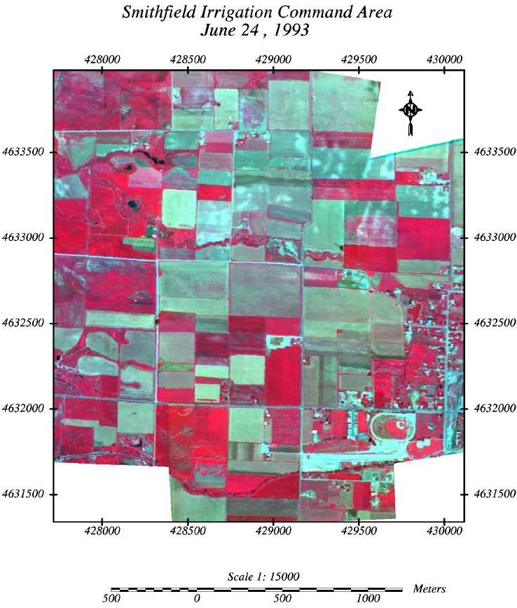
31 Development of the Reflectance-based Crop Coefficient for Potatoes
32 SAVI versus LAI Relationship for Potatoes
33 Simulation of soil moisture in the root zone of potato crop using both the basal and the reflectance-based Kc Kcr = * SAVI
34 Measured vs Estimated Soil Moisture

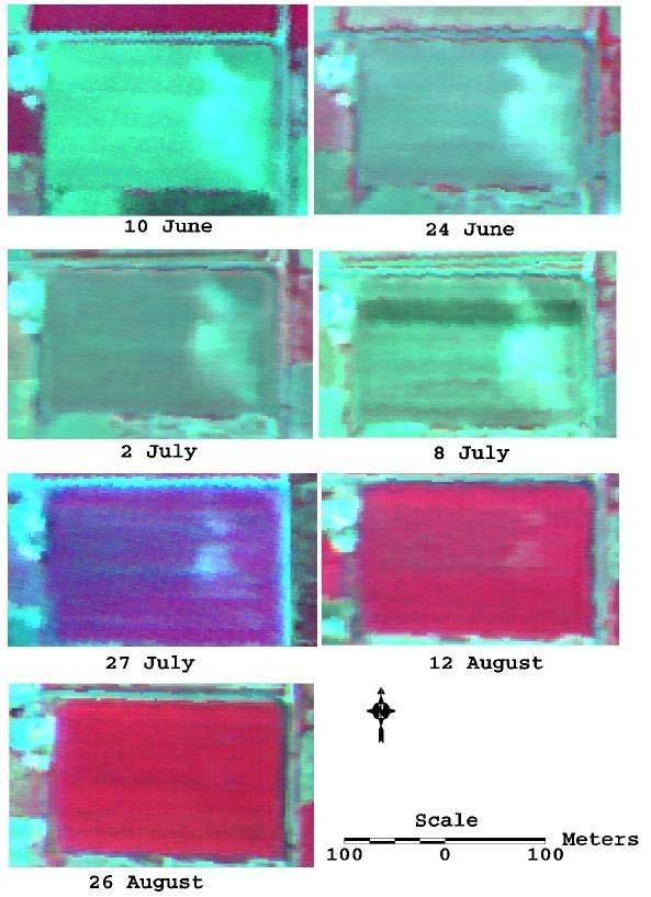
35 Cummins center pivot #3 with Russet Burbank Potatoes

36 In-field variability of crop growth has implications for both crop ET estimates and also yield
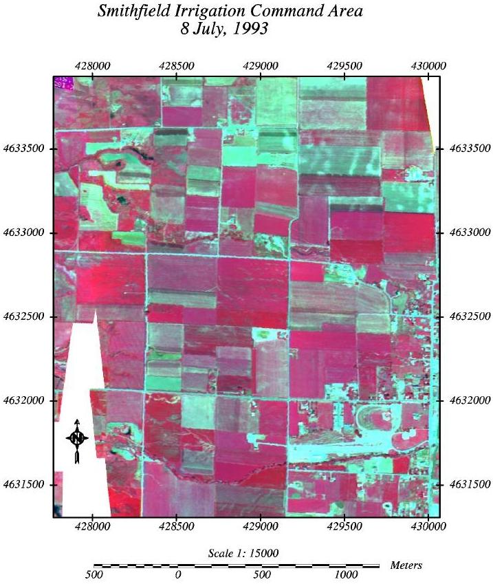
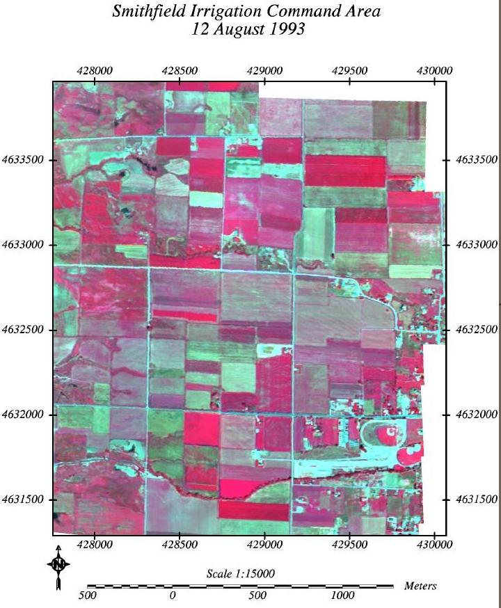
37 Verification of Crop Coefficient Methodology at Irrigation Command Area Scales Smithfield canal company (gravity fed sprinkler system with 347 ha) Irrigation water deliveries measured at inlet Crops: Alfalfa, barley, corn, pasture Airborne imagery acquired over 1993 season using USU airborne system GIS database with soil layer, crop layer Reference ET from nearby weather station Calibrated imagery used to obtain reflectance based crop coefficient for each field 7 flights throughout growing season
38 Cropping Pattern 1993 of Smithfield Command Area
39 Soil Type Layer of Smithfield Command Area
40
41
42
43
44

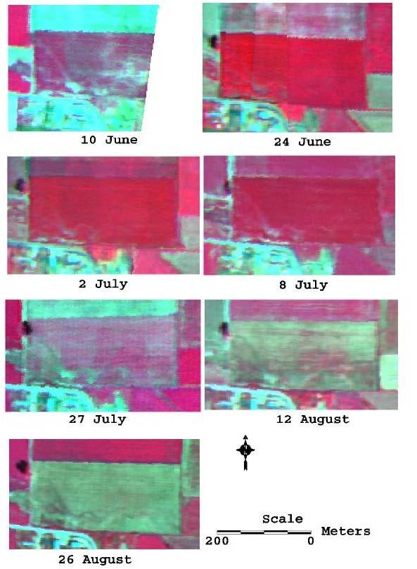
45 Crop Development Progression Alfalfa Barley Corn
46 Seasonal SAVI Trends
47 Estimated Demand and Measured Irrigation Water Deliveries for Smithfield Command Area in 1993
48 Final Comments Future research should consider the effects of irrigation water management on yield Energy Balance or Kcr models should be verified in irrigation systems where water balance can be performed Simple Kcr models can perform well Future potato and sugar beet yield models under development will include distributed actual ET estimates and localized stress within the fields High-resolution imagery is useful for precision agricultural applications
49 Thank you
Spatial mapping of évapotranspiration and energy balance components over riparian vegetation using airborne remote sensing
 Remole Sensing and Hydrology 2000 (Proceedings of a symposium held at Santa Fe, New Mexico, USA, April 2000). IAHS Publ. no. 267, 2001. 311 Spatial mapping of évapotranspiration and energy balance components
Monitoring Geothermal Activity in Yellowstone National Park Using Airborne Thermal Infrared Remote Sensing
 Monitoring Geothermal Activity in Yellowstone National Park Using Airborne Thermal Infrared Remote Sensing CMU Neale *a, S. Sivarajan a, O. Z. Akasheh b, C. Jaworowski c, H. Heasler c a Biological and
Central Platte Natural Resources District-Remote Sensing/Satellite Evapotranspiration Project. Progress Report September 2009 TABLE OF CONTENTS
 Central Platte Natural Resources District-Remote Sensing/Satellite Evapotranspiration Project Progress Report September 2009 Ayse Irmak, Ph.D. Assistant Professor School of Natural Resources, Department
MAPPING TURF EVAPOTRANSPIRATION WITH HIGH-RESOLUTION MULTISPECTRAL AERIAL IMAGERY
 MAPPING TURF EVAPOTRANSPIRATION WITH HIGH-RESOLUTION MULTISPECTRAL AERIAL IMAGERY M. J. Hattendorf Northern Colorado Water Conservancy District, 220 Water Ave, Berthoud, CO mhattendorf@northernwater.org
Enhancement of Multispectral Images and Vegetation Indices
 Enhancement of Multispectral Images and Vegetation Indices ERDAS Imagine 2016 Description: We will use ERDAS Imagine with multispectral images to learn how an image can be enhanced for better interpretation.
Remote Sensing Phenology. Bradley Reed Principal Scientist USGS National Center for Earth Resources Observation and Science Sioux Falls, SD
 Remote Sensing Phenology Bradley Reed Principal Scientist USGS National Center for Earth Resources Observation and Science Sioux Falls, SD Remote Sensing Phenology Potential to provide wall-to-wall phenology
SUGAR_GIS. From a user perspective. Provides spatial distribution of a wide range of sugarcane production data in an easy to use and sensitive way.
 SUGAR_GIS From a user perspective What is Sugar_GIS? A web-based, decision support tool. Provides spatial distribution of a wide range of sugarcane production data in an easy to use and sensitive way.
Remote sensing in FIGARO
 FIGARO FLEXIBLE AND PRECISE IRRIGATION PLATFORM TO IMPROVE FARM SCALE WATER PRODUCTIVITY Remote sensing in FIGARO Final Meeting, Brussels 19/09/2016 Technical University of Valencia Use of Remote sensing
746A27 Remote Sensing and GIS. Multi spectral, thermal and hyper spectral sensing and usage
 746A27 Remote Sensing and GIS Lecture 3 Multi spectral, thermal and hyper spectral sensing and usage Chandan Roy Guest Lecturer Department of Computer and Information Science Linköping University Multi
Center for Advanced Land Management Information Technologies (CALMIT), School of Natural Resources, University of Nebraska-Lincoln
, School of Natural Resources, University of Nebraska-Lincoln") Geoffrey M. Henebry, Andrés Viña, and Anatoly A. Gitelson Center for Advanced Land Management Information Technologies (CALMIT), School of Natural Resources, University of Nebraska-Lincoln Introduction
Geoffrey M. Henebry, Andrés Viña, and Anatoly A. Gitelson Center for Advanced Land Management Information Technologies (CALMIT), School of Natural Resources, University of Nebraska-Lincoln Introduction
Camera Requirements For Precision Agriculture
 Camera Requirements For Precision Agriculture Radiometric analysis such as NDVI requires careful acquisition and handling of the imagery to provide reliable values. In this guide, we explain how Pix4Dmapper
REMOTE SENSING. Topic 10 Fundamentals of Digital Multispectral Remote Sensing MULTISPECTRAL SCANNERS MULTISPECTRAL SCANNERS
 REMOTE SENSING Topic 10 Fundamentals of Digital Multispectral Remote Sensing Chapter 5: Lillesand and Keifer Chapter 6: Avery and Berlin MULTISPECTRAL SCANNERS Record EMR in a number of discrete portions
Camera Requirements For Precision Agriculture
 Camera Requirements For Precision Agriculture Radiometric analysis such as NDVI requires careful acquisition and handling of the imagery to provide reliable values. In this guide, we explain how Pix4Dmapper
typical spectral signatures of photosynthetically active and non-photosynthetically active vegetation (Beeri et al., 2007)
") typical spectral signatures of photosynthetically active and non-photosynthetically active vegetation (Beeri et al., 2007) Xie, Y. et al. J Plant Ecol 2008 1:9-23; doi:10.1093/jpe/rtm005 Copyright restrictions
typical spectral signatures of photosynthetically active and non-photosynthetically active vegetation (Beeri et al., 2007) Xie, Y. et al. J Plant Ecol 2008 1:9-23; doi:10.1093/jpe/rtm005 Copyright restrictions
Integrated Study of Systematic Monitoring and Mapping Thermal Springs and Features in Yellowstone National Park
 Integrated Study of Systematic Monitoring and Mapping Thermal Springs and Features in Yellowstone National Park Final Report For CESU Task Agreements J1580090425 and J1580050608 From 2008 to 2009 By Christopher
An Introduction to Remote Sensing & GIS. Introduction
 An Introduction to Remote Sensing & GIS Introduction Remote sensing is the measurement of object properties on Earth s surface using data acquired from aircraft and satellites. It attempts to measure something
RADIOMETRIC CALIBRATION
 1 RADIOMETRIC CALIBRATION Lecture 10 Digital Image Data 2 Digital data are matrices of digital numbers (DNs) There is one layer (or matrix) for each satellite band Each DN corresponds to one pixel 3 Digital
NON-PHOTOGRAPHIC SYSTEMS: Multispectral Scanners Medium and coarse resolution sensor comparisons: Landsat, SPOT, AVHRR and MODIS
 NON-PHOTOGRAPHIC SYSTEMS: Multispectral Scanners Medium and coarse resolution sensor comparisons: Landsat, SPOT, AVHRR and MODIS CLASSIFICATION OF NONPHOTOGRAPHIC REMOTE SENSORS PASSIVE ACTIVE DIGITAL
RICE EVAPOTRANSPIRATION ESTIMATION USING SATELLITE DATA
 RICE EVAPOTRANSPIRATION ESTIMATION USING SATELLITE DATA MSM Amin and SMH Hassan Department of Biological and Agricultural Engineering Universiti Putra Malaysia amin@eng.upm.edu.my and hilmi_aau@hotmail.com
[GEOMETRIC CORRECTION, ORTHORECTIFICATION AND MOSAICKING]
![[GEOMETRIC CORRECTION, ORTHORECTIFICATION AND MOSAICKING]](/thumbs/78/78211997.jpg "[GEOMETRIC CORRECTION, ORTHORECTIFICATION AND MOSAICKING]") 2013 Ogis-geoInfo Inc. IBEABUCHI NKEMAKOLAM.J [GEOMETRIC CORRECTION, ORTHORECTIFICATION AND MOSAICKING] [Type the abstract of the document here. The abstract is typically a short summary of the contents
2013 Ogis-geoInfo Inc. IBEABUCHI NKEMAKOLAM.J [GEOMETRIC CORRECTION, ORTHORECTIFICATION AND MOSAICKING] [Type the abstract of the document here. The abstract is typically a short summary of the contents
CLASSIFICATION OF VEGETATION AREA FROM SATELLITE IMAGES USING IMAGE PROCESSING TECHNIQUES ABSTRACT
 CLASSIFICATION OF VEGETATION AREA FROM SATELLITE IMAGES USING IMAGE PROCESSING TECHNIQUES Arpita Pandya Research Scholar, Computer Science, Rai University, Ahmedabad Dr. Priya R. Swaminarayan Professor
Comprehensive Vicarious Calibration and Characterization of a Small Satellite Constellation Using the Specular Array Calibration (SPARC) Method
 Method") This document does not contain technology or Technical Data controlled under either the U.S. International Traffic in Arms Regulations or the U.S. Export Administration Regulations. Comprehensive Vicarious
This document does not contain technology or Technical Data controlled under either the U.S. International Traffic in Arms Regulations or the U.S. Export Administration Regulations. Comprehensive Vicarious
Introduction to Remote Sensing Fundamentals of Satellite Remote Sensing. Mads Olander Rasmussen
 Introduction to Remote Sensing Fundamentals of Satellite Remote Sensing Mads Olander Rasmussen (mora@dhi-gras.com) 01. Introduction to Remote Sensing DHI What is remote sensing? the art, science, and technology
ENHANCED RESOLUTION OF EVAPOTRANSPIRATION BY SHARPENING THE LANDSAT THERMAL BAND
 ENHANCED RESOLUTION OF EVAPOTRANSPIRATION BY SHARPENING THE LANDSAT THERMAL BAND Richard G. Allen, Professor Clarence W. Robison, Research Associate Magali Garcia, Visiting Professor Jeppe Kjaersgaard,
Introduction of Satellite Remote Sensing
 Introduction of Satellite Remote Sensing Spatial Resolution (Pixel size) Spectral Resolution (Bands) Resolutions of Remote Sensing 1. Spatial (what area and how detailed) 2. Spectral (what colors bands)
Application of GIS to Fast Track Planning and Monitoring of Development Agenda
 Application of GIS to Fast Track Planning and Monitoring of Development Agenda Radiometric, Atmospheric & Geometric Preprocessing of Optical Remote Sensing 13 17 June 2018 Outline 1. Why pre-process remotely
Preparing for the exploitation of Sentinel-2 data for agriculture monitoring. JACQUES Damien, DEFOURNY Pierre UCL-Geomatics Lab 2 octobre 2013
 Preparing for the exploitation of Sentinel-2 data for agriculture monitoring JACQUES Damien, DEFOURNY Pierre UCL-Geomatics Lab 2 octobre 2013 Agriculture monitoring, why? - Growing speculation on food
Spectral Signatures. Vegetation. 40 Soil. Water WAVELENGTH (microns)
") Spectral Signatures % REFLECTANCE VISIBLE NEAR INFRARED Vegetation Soil Water.5. WAVELENGTH (microns). Spectral Reflectance of Urban Materials 5 Parking Lot 5 (5=5%) Reflectance 5 5 5 5 5 Wavelength (nm)
Spectral Signatures % REFLECTANCE VISIBLE NEAR INFRARED Vegetation Soil Water.5. WAVELENGTH (microns). Spectral Reflectance of Urban Materials 5 Parking Lot 5 (5=5%) Reflectance 5 5 5 5 5 Wavelength (nm)
MULTISPECTRAL AGRICULTURAL ASSESSMENT. Normalized Difference Vegetation Index. Federal Robotics INSPECTION & DOCUMENTATION
 MULTISPECTRAL AGRICULTURAL ASSESSMENT Normalized Difference Vegetation Index INSPECTION & DOCUMENTATION Federal Robotics Clearwater Dr. Amherst, New York 14228 716-221-4181 Sales@FedRobot.com www.fedrobot.com
Atmospheric Correction (including ATCOR)
") Technical Specifications Atmospheric Correction (including ATCOR) The data obtained by optical satellite sensors with high spatial resolution has become an invaluable tool for many groups interested in
Technical Specifications Atmospheric Correction (including ATCOR) The data obtained by optical satellite sensors with high spatial resolution has become an invaluable tool for many groups interested in
Remote Sensing for Rangeland Applications
 Remote Sensing for Rangeland Applications Jay Angerer Ecological Training June 16, 2012 Remote Sensing The term "remote sensing," first used in the United States in the 1950s by Ms. Evelyn Pruitt of the
Abstract Urbanization and human activities cause higher air temperature in urban areas than its
 Observe Urban Heat Island in Lucas County Using Remote Sensing by Lu Zhao Table of Contents Abstract Introduction Image Processing Proprocessing Temperature Calculation Land Use/Cover Detection Results
The techniques with ERDAS IMAGINE include:
 The techniques with ERDAS IMAGINE include: 1. Data correction - radiometric and geometric correction 2. Radiometric enhancement - enhancing images based on the values of individual pixels 3. Spatial enhancement
Camera Calibration Certificate No: DMC III 27542
 Calibration DMC III Camera Calibration Certificate No: DMC III 27542 For Peregrine Aerial Surveys, Inc. #201 1255 Townline Road Abbotsford, B.C. V2T 6E1 Canada Calib_DMCIII_27542.docx Document Version
REMOTE SENSING INTERPRETATION
 REMOTE SENSING INTERPRETATION Jan Clevers Centre for Geo-Information - WU Remote Sensing --> RS Sensor at a distance EARTH OBSERVATION EM energy Earth RS is a tool; one of the sources of information! 1
Dirty REMOTE SENSING Lecture 3: First Steps in classifying Stuart Green Earthobservation.wordpress.com
 Dirty REMOTE SENSING Lecture 3: First Steps in classifying Stuart Green Earthobservation.wordpress.com Stuart.Green@Teagasc.ie You have your image, but is it any good? Is it full of cloud? Is it the right
APPLICATIONS AND LESSONS LEARNED WITH AIRBORNE MULTISPECTRAL IMAGING
 APPLICATIONS AND LESSONS LEARNED WITH AIRBORNE MULTISPECTRAL IMAGING James M. Ellis and Hugh S. Dodd The MapFactory and HJW Walnut Creek and Oakland, California, U.S.A. ABSTRACT Airborne digital frame
Remote sensing image correction
 Remote sensing image correction Introductory readings remote sensing http://www.microimages.com/documentation/tutorials/introrse.pdf 1 Preprocessing Digital Image Processing of satellite images can be
Remote Sensing in Daily Life. What Is Remote Sensing?
 Remote Sensing in Daily Life What Is Remote Sensing? First time term Remote Sensing was used by Ms Evelyn L Pruitt, a geographer of US in mid 1950s. Minimal definition (not very useful): remote sensing
The New Rig Camera Process in TNTmips Pro 2018
 The New Rig Camera Process in TNTmips Pro 2018 Jack Paris, Ph.D. Paris Geospatial, LLC, 3017 Park Ave., Clovis, CA 93611, 559-291-2796, jparis37@msn.com Kinds of Digital Cameras for Drones Two kinds of
Introduction to Remote Sensing
 Introduction to Remote Sensing Spatial, spectral, temporal resolutions Image display alternatives Vegetation Indices Image classifications Image change detections Accuracy assessment Satellites & Air-Photos
Int n r t o r d o u d c u ti t on o n to t o Remote Sensing
 Introduction to Remote Sensing Definition of Remote Sensing Remote sensing refers to the activities of recording/observing/perceiving(sensing)objects or events at far away (remote) places. In remote sensing,
How to Access Imagery and Carry Out Remote Sensing Analysis Using Landsat Data in a Browser
 How to Access Imagery and Carry Out Remote Sensing Analysis Using Landsat Data in a Browser Including Introduction to Remote Sensing Concepts Based on: igett Remote Sensing Concept Modules and GeoTech
TEMPORAL ANALYSIS OF MULTI EPOCH LANDSAT GEOCOVER IMAGES IN ZONGULDAK TESTFIELD
 TEMPORAL ANALYSIS OF MULTI EPOCH LANDSAT GEOCOVER IMAGES IN ZONGULDAK TESTFIELD Şahin, H. a*, Oruç, M. a, Büyüksalih, G. a a Zonguldak Karaelmas University, Zonguldak, Turkey - (sahin@karaelmas.edu.tr,
Geometric Validation of Hyperion Data at Coleambally Irrigation Area
 Geometric Validation of Hyperion Data at Coleambally Irrigation Area Tim McVicar, Tom Van Niel, David Jupp CSIRO, Australia Jay Pearlman, and Pamela Barry TRW, USA Background RICE SOYBEANS The Coleambally
Satellite Remote Sensing: Earth System Observations
 Satellite Remote Sensing: Earth System Observations Land surface Water Atmosphere Climate Ecosystems 1 EOS (Earth Observing System) Develop an understanding of the total Earth system, and the effects of
Remote sensing in archaeology from optical to lidar. Krištof Oštir ModeLTER Scientific Research Centre of the Slovenian Academy of Sciences and Arts
 Remote sensing in archaeology from optical to lidar Krištof Oštir ModeLTER Scientific Research Centre of the Slovenian Academy of Sciences and Arts Introduction Optical remote sensing Systems Search for
Introduction to Remote Sensing Part 1
 Introduction to Remote Sensing Part 1 A Primer on Electromagnetic Radiation Digital, Multi-Spectral Imagery The 4 Resolutions Displaying Images Corrections and Enhancements Passive vs. Active Sensors Radar
Remote Sensing Platforms
 Types of Platforms Lighter-than-air Remote Sensing Platforms Free floating balloons Restricted by atmospheric conditions Used to acquire meteorological/atmospheric data Blimps/dirigibles Major role - news
An NDVI image provides critical crop information that is not visible in an RGB or NIR image of the same scene. For example, plants may appear green
 Normalized Difference Vegetation Index (NDVI) Spectral Band calculation that uses the visible (RGB) and near-infrared (NIR) bands of the electromagnetic spectrum NDVI= + An NDVI image provides critical
AT-SATELLITE REFLECTANCE: A FIRST ORDER NORMALIZATION OF LANDSAT 7 ETM+ IMAGES
 AT-SATELLITE REFLECTANCE: A FIRST ORDER NORMALIZATION OF LANDSAT 7 ETM+ IMAGES Chengquan Huang*, Limin Yang, Collin Homer, Bruce Wylie, James Vogelman and Thomas DeFelice Raytheon ITSS, EROS Data Center
Development of normalized vegetation, soil and water indices derived from satellite remote sensing data
 Development of normalized vegetation, soil and water indices derived from satellite remote sensing data Takeuchi, W. & Yasuoka, Y. IIS/UT, Japan E-mail: wataru@iis.u-tokyo.ac.jp Nov. 25th, 2004 ACRS2004
CALMIT Field Program. Center for Advanced Land Management Information Technologies (CALMIT) University of Nebraska Lincoln
 University of Nebraska Lincoln") CALMIT Field Program Center for Advanced Land Management Information Technologies (CALMIT) University of Nebraska Lincoln Field Program: Three Areas Agriculture Surface Waters Coastal / Marine 1) Agriculture
CALMIT Field Program Center for Advanced Land Management Information Technologies (CALMIT) University of Nebraska Lincoln Field Program: Three Areas Agriculture Surface Waters Coastal / Marine 1) Agriculture
On the sensitivity of Land Surface Temperature estimates in arid irrigated lands using MODTRAN
 21st International Congress on Modelling and Simulation, Gold Coast, Australia, 29 Nov to 4 Dec 2015 www.mssanz.org.au/modsim2015 On the sensitivity of Land Surface Temperature estimates in arid irrigated
Procedures for Correcting Digital Camera Imagery Acquired by the AggieAir Remote Sensing Platform
 Utah State University DigitalCommons@USU All Graduate Plan B and other Reports Graduate Studies 5-2012 Procedures for Correcting Digital Camera Imagery Acquired by the AggieAir Remote Sensing Platform
GIS Data Collection. Remote Sensing
 GIS Data Collection Remote Sensing Data Collection Remote sensing Introduction Concepts Spectral signatures Resolutions: spectral, spatial, temporal Digital image processing (classification) Other systems
Precision Remote Sensing and Image Processing for Precision Agriculture (PA)
") Precision Remote Sensing and Image Processing for Precision Agriculture (PA) Dr. Jack F. Paris Presented to Colorado State University, Fort Collins, CO October 20, 2005 Speaker s Current Activities: Consultant
Precision Remote Sensing and Image Processing for Precision Agriculture (PA) Dr. Jack F. Paris Presented to Colorado State University, Fort Collins, CO October 20, 2005 Speaker s Current Activities: Consultant
Image Band Transformations
 Image Band Transformations Content Band math Band ratios Vegetation Index Tasseled Cap Transform Principal Component Analysis (PCA) Decorrelation Stretch Image Band Transformation Purposes Image band transforms
MRLC 2001 IMAGE PREPROCESSING PROCEDURE
 MRLC 2001 IMAGE PREPROCESSING PROCEDURE The core dataset of the MRLC 2001 database consists of Landsat 7 ETM+ images. Image selection is based on vegetation greenness profiles defined by a multi-year normalized
Chapter 5. Preprocessing in remote sensing
 Chapter 5. Preprocessing in remote sensing 5.1 Introduction Remote sensing images from spaceborne sensors with resolutions from 1 km to < 1 m become more and more available at reasonable costs. For some
MSB Imagery Program FAQ v1
 MSB Imagery Program FAQ v1 (F)requently (A)sked (Q)uestions 9/22/2016 This document is intended to answer commonly asked questions related to the MSB Recurring Aerial Imagery Program. Table of Contents
An Analysis of Aerial Imagery and Yield Data Collection as Management Tools in Rice Production
 RICE CULTURE An Analysis of Aerial Imagery and Yield Data Collection as Management Tools in Rice Production C.W. Jayroe, W.H. Baker, and W.H. Robertson ABSTRACT Early estimates of yield and correcting
Lecture 13: Remotely Sensed Geospatial Data
 Lecture 13: Remotely Sensed Geospatial Data A. The Electromagnetic Spectrum: The electromagnetic spectrum (Figure 1) indicates the different forms of radiation (or simply stated light) emitted by nature.
APCAS/10/21 April 2010 ASIA AND PACIFIC COMMISSION ON AGRICULTURAL STATISTICS TWENTY-THIRD SESSION. Siem Reap, Cambodia, April 2010
 APCAS/10/21 April 2010 Agenda Item 8 ASIA AND PACIFIC COMMISSION ON AGRICULTURAL STATISTICS TWENTY-THIRD SESSION Siem Reap, Cambodia, 26-30 April 2010 The Use of Remote Sensing for Area Estimation by Robert
Geo-localization and Mosaicing System (GEMS): Enabling Precision Image Feature Location and Rapid Mosaicing General:
: Enabling Precision Image Feature Location and Rapid Mosaicing General:") Geo-localization and Mosaicing System (GEMS): Enabling Precision Image Feature Location and Rapid Mosaicing General: info@senteksystems.com www.senteksystems.com 12/6/2014 Precision Agriculture Multi-Spectral
Geo-localization and Mosaicing System (GEMS): Enabling Precision Image Feature Location and Rapid Mosaicing General: info@senteksystems.com www.senteksystems.com 12/6/2014 Precision Agriculture Multi-Spectral
Image transformations
 Image transformations Digital Numbers may be composed of three elements: Atmospheric interference (e.g. haze) ATCOR Illumination (angle of reflection) - transforms Albedo (surface cover) Image transformations
Urban Classification of Metro Manila for Seismic Risk Assessment using Satellite Images
 Urban Classification of Metro Manila for Seismic Risk Assessment using Satellite Images Fumio YAMAZAKI/ yamazaki@edm.bosai.go.jp Hajime MITOMI/ mitomi@edm.bosai.go.jp Yalkun YUSUF/ yalkun@edm.bosai.go.jp
Determining the green vegetation fraction from RapidEye data for use in regional climate simulations
 Research Unit 1695 Determining the green vegetation fraction from RapidEye data for use in regional climate simulations Kristina Imukova, Joachim Ingwersen and Thilo Streck Institute of Soil Science and
SUGARCANE GROUND REFERENCE DATA OVER FOUR FIELDS IN SÃO PAULO STATE
 SUGARCANE GROUND REFERENCE DATA OVER FOUR FIELDS IN SÃO PAULO STATE Document created: 23/02/2016 by R.A. Molijn. INTRODUCTION This document is meant as a guide to the dataset and gives an insight into
Remote Sensing. Measuring an object from a distance. For GIS, that means using photographic or satellite images to gather spatial data
 Remote Sensing Measuring an object from a distance For GIS, that means using photographic or satellite images to gather spatial data Remote Sensing measures electromagnetic energy reflected or emitted
Lecture 2. Electromagnetic radiation principles. Units, image resolutions.
 NRMT 2270, Photogrammetry/Remote Sensing Lecture 2 Electromagnetic radiation principles. Units, image resolutions. Tomislav Sapic GIS Technologist Faculty of Natural Resources Management Lakehead University
Mod. 2 p. 1. Prof. Dr. Christoph Kleinn Institut für Waldinventur und Waldwachstum Arbeitsbereich Fernerkundung und Waldinventur
 Histograms of gray values for TM bands 1-7 for the example image - Band 4 and 5 show more differentiation than the others (contrast=the ratio of brightest to darkest areas of a landscape). - Judging from
A map says to you, 'Read me carefully, follow me closely, doubt me not.' It says, 'I am the Earth in the palm of your hand. Without me, you are alone
 A map says to you, 'Read me carefully, follow me closely, doubt me not.' It says, 'I am the Earth in the palm of your hand. Without me, you are alone and lost. Beryl Markham (West With the Night, 1946
RETRIEVING BIOPHYSICAL DATA FROM AIRBORNE MULTISPECTRAL IMAGERY OF RICE CROPS
 RETRIEVING BIOPHYSICAL DATA FROM AIRBORNE MULTISPECTRAL IMAGERY OF RICE CROPS Sarah SPACKMAN, Gary McKENZIE*, David LAMB, John LOUIS CRC for Sustainable Rice Production, Charles Sturt University, Wagga
Analysis of vegetation indices derived from aerial multispectral and ground hyperspectral data
 September, 2009 Int J Agric & Biol Eng Open Access at http://www.ijabe.org Vol. 2 No.3 33 Analysis of vegetation indices derived from aerial multispectral and ground hyperspectral data Huihui Zhang 1,
Airborne hyperspectral data over Chikusei
 SPACE APPLICATION LABORATORY, THE UNIVERSITY OF TOKYO Airborne hyperspectral data over Chikusei Naoto Yokoya and Akira Iwasaki E-mail: {yokoya, aiwasaki}@sal.rcast.u-tokyo.ac.jp May 27, 2016 ABSTRACT Airborne
Sommersemester Prof. Dr. Christoph Kleinn Institut für Waldinventur und Waldwachstum Arbeitsbereich Fernerkundung und Waldinventur.
 Basics of Remote Sensing Some literature references Franklin, SE 2001 Remote Sensing for Sustainable Forest Management Lewis Publishers 407p Lillesand, Kiefer 2000 Remote Sensing and Image Interpretation
LAST GENERATION UAV-BASED MULTI- SPECTRAL CAMERA FOR AGRICULTURAL DATA ACQUISITION
 LAST GENERATION UAV-BASED MULTI- SPECTRAL CAMERA FOR AGRICULTURAL DATA ACQUISITION FABIO REMONDINO, Erica Nocerino, Fabio Menna Fondazione Bruno Kessler Trento, Italy http://3dom.fbk.eu Marco Dubbini,
HIGH RESOLUTION COLOR IMAGERY FOR ORTHOMAPS AND REMOTE SENSING. Author: Peter Fricker Director Product Management Image Sensors
 HIGH RESOLUTION COLOR IMAGERY FOR ORTHOMAPS AND REMOTE SENSING Author: Peter Fricker Director Product Management Image Sensors Co-Author: Tauno Saks Product Manager Airborne Data Acquisition Leica Geosystems
Remote Sensing. The following figure is grey scale display of SPOT Panchromatic without stretching.
 Remote Sensing Objectives This unit will briefly explain display of remote sensing image, geometric correction, spatial enhancement, spectral enhancement and classification of remote sensing image. At
Basic Digital Image Processing. The Structure of Digital Images. An Overview of Image Processing. Image Restoration: Line Drop-outs
 Basic Digital Image Processing A Basic Introduction to Digital Image Processing ~~~~~~~~~~ Rev. Ronald J. Wasowski, C.S.C. Associate Professor of Environmental Science University of Portland Portland,
Passive Microwave Sensors LIDAR Remote Sensing Laser Altimetry. 28 April 2003
 Passive Microwave Sensors LIDAR Remote Sensing Laser Altimetry 28 April 2003 Outline Passive Microwave Radiometry Rayleigh-Jeans approximation Brightness temperature Emissivity and dielectric constant
The studies began when the Tiros satellites (1960) provided man s first synoptic view of the Earth s weather systems.
 provided man s first synoptic view of the Earth s weather systems.") Remote sensing of the Earth from orbital altitudes was recognized in the mid-1960 s as a potential technique for obtaining information important for the effective use and conservation of natural resources.
Remote sensing of the Earth from orbital altitudes was recognized in the mid-1960 s as a potential technique for obtaining information important for the effective use and conservation of natural resources.
SWAT LAI calibration with local LAI measurements
 SWAT LAI calibration with local LAI measurements Carina Almeida Pedro Chambel-Leitão, Eduardo Jauch, Ramiro Neves Instituto Superior Técnico, Technical University of Lisbon Av. Rovisco Pais 1049-001 Lisbon,
Preparing Remote Sensing Data for Natural Resources Mapping (image enhancement, rectifications )
") Preparing Remote Sensing Data for Natural Resources Mapping (image enhancement, rectifications ) Why is this important What are the major approaches Examples of digital image enhancement Follow up exercises
Preparing Remote Sensing Data for Natural Resources Mapping (image enhancement, rectifications ) Why is this important What are the major approaches Examples of digital image enhancement Follow up exercises
Summary. Introduction. Remote Sensing Basics. Selecting a Remote Sensing Product
 K. Dalsted, J.F. Paris, D.E. Clay, S.A. Clay, C.L. Reese, and J. Chang SSMG-40 Selecting the Appropriate Satellite Remote Sensing Product for Precision Farming Summary Given the large number of satellite
A Digital Airborne Camera System for Photogrammetry and Thematic Applications
 A Digital Airborne Camera System for Photogrammetry and Thematic Applications Helmut Heier, Alexander Hinz Z/I Imaging GmbH 73442 Oberkochen, Germany Fax : +49-7364-20 3724 email: heier@zeiss.de KEYWORDS:
Outline for today. Geography 411/611 Remote sensing: Principles and Applications. Remote sensing: RS for biogeochemical cycles
 Geography 411/611 Remote sensing: Principles and Applications Thomas Albright, Associate Professor Laboratory for Conservation Biogeography, Department of Geography & Program in Ecology, Evolution, & Conservation
Module 3 Introduction to GIS. Lecture 8 GIS data acquisition
 Module 3 Introduction to GIS Lecture 8 GIS data acquisition GIS workflow Data acquisition (geospatial data input) GPS Remote sensing (satellites, UAV s) LiDAR Digitized maps Attribute Data Management Data
Satellite data processing and analysis: Examples and practical considerations
 Satellite data processing and analysis: Examples and practical considerations Dániel Kristóf Ottó Petrik, Róbert Pataki, András Kolesár International LCLUC Regional Science Meeting in Central Europe Sopron,
Valuable New Information for Precision Agriculture. Mike Ritter Founder & CEO - SLANTRANGE, Inc.
 Valuable New Information for Precision Agriculture Mike Ritter Founder & CEO - SLANTRANGE, Inc. SENSORS Accurate, Platform- Agnostic ANALYTICS On-Board, On-Location SLANTRANGE Delivering Valuable New Information
Environmental and Natural Resources Issues in Minnesota. A Remote Sensing Overview: Principles and Fundamentals. Outline. Challenges.
 A Remote Sensing Overview: Principles and Fundamentals Marvin Bauer Remote Sensing and Geospatial Analysis Laboratory College of Natural Resources University of Minnesota Remote Sensing for GIS Users Workshop,
Remote Sensing. in Agriculture. Dr. Baqer Ramadhan CRP 514 Geographic Information System. Adel M. Al-Rebh G Term Paper.
 Remote Sensing in Agriculture Term Paper to Dr. Baqer Ramadhan CRP 514 Geographic Information System By Adel M. Al-Rebh G199325390 May 2012 Table of Contents 1.0 Introduction... 4 2.0 Objective... 4 3.0
LIFE ENVIRONMENT STRYMON
 LIFE ENVIRONMENT STRYMON Ecosystem Based Water Resources Management to Minimize Environmental Impacts from Agriculture Using State of the Art Modeling Tools in Strymonas Basin LIFE03 ENV/GR/000217 Task
At-Satellite Reflectance: A First Order Normalization Of Landsat 7 ETM+ Images
 University of Nebraska - Lincoln DigitalCommons@University of Nebraska - Lincoln Publications of the US Geological Survey US Geological Survey 21 At-Satellite Reflectance: A First Order Normalization Of
High Resolution Multi-spectral Imagery
 High Resolution Multi-spectral Imagery Jim Baily, AirAgronomics AIRAGRONOMICS Having been involved in broadacre agriculture until 2000 I perceived a need for a high resolution remote sensing service to
Separation of crop and vegetation based on Digital Image Processing
 Separation of crop and vegetation based on Digital Image Processing Mayank Singh Sakla 1, Palak Jain 2 1 M.TECH GEOMATICS student, CEPT UNIVERSITY 2 M.TECH GEOMATICS student, CEPT UNIVERSITY Word Limit
Calibration Report. Short Version. Vexcel Imaging GmbH, A-8010 Graz, Austria
 Calibration Report Short Version Camera: Manufacturer: UltraCam D, S/N UCD-SU-2-0039 Vexcel Imaging GmbH, A-8010 Graz, Austria Date of Calibration: Mar-14-2011 Date of Report: Mar-17-2011 Camera Revision:
New capabilities in Earth Observation for agriculture
 New capabilities in Earth Observation for agriculture Prof. Katarzyna Dabrowska-Zielinska Head of Remote Sensing Department Institute of Geodesy and Cartography Modzelewskiego 27 Street 02-679 Warsaw Poland
Characterization of the atmospheric aerosols and the surface radiometric properties in the AGRISAR Campaign
 Characterization of the atmospheric aerosols and the surface radiometric properties in the AGRISAR Campaign V. Estellés Solar Radiation Unit Universitat de València T. Ruhtz, P. Zieger, S. Stapelberg Institute