CENTRA Technology, Inc. V 1.2
|
|
|
- Marcia West
- 6 years ago
- Views:
Transcription


1 CENTRA Technology, Inc. V 1.2
2 International Products Catalog 2013 CENTRA works to develop customized, affordable, and fully exportable technical solutions for our international clients priority missions. CENTRA operations professionals identify ready, off-the-shelf technologies and combine them with proven operational tradecraft and training programs to deliver sustainable, organic capabilities that meet or exceed mission requirements. Our professionals are technology agnostic and continuously review the marketplace for technology developments and products that could offer new or improved solutions at lower cost. CENTRA maintains relationships and reseller agreements with multiple manufacturers and vendors giving us ready access to a wide range of exportable products and technologies. These products include fully-integrated Intelligence, Surveillance and Reconnaissance (ISR) system networks tailored to various operating environments. Along with our range of technical products and solutions, CENTRA provides full spectrum Train, Equip, Advise, and Assist services to international partners. Our staff comes from the Special Operations, Intelligence and Law Enforcement Communities with experience in special collection activities, HUMINT and SIGINT operations, airborne and maritime activities, search and rescue, geo-location, Counter narcotic and Counterterrorism operations. CENTRA s professionals have managed highly complex technical operations programs worldwide and have demonstrated success in implementing technical advisory and training programs with foreign partners.
3 International Products Catalog Table of Contents Advanced Radio Direction Finder 4 (Series 7000MPT) Communication Systems & Network Services 5 Unattended Ground Sensor Node 6 Airborne Synthetic Aperture Radar (SAR) with Ground Moving Target Indication (GMTI) 7 Intelligence, Surveillance, Reconnaissance (ISR) System Components 8 Integrated ISR Solution #1 Mobile Optical Radar Sensor System (MORSS) 9 Integrated ISR Solution #2 Intelligent Border Surveillance Network (IBSN) 10


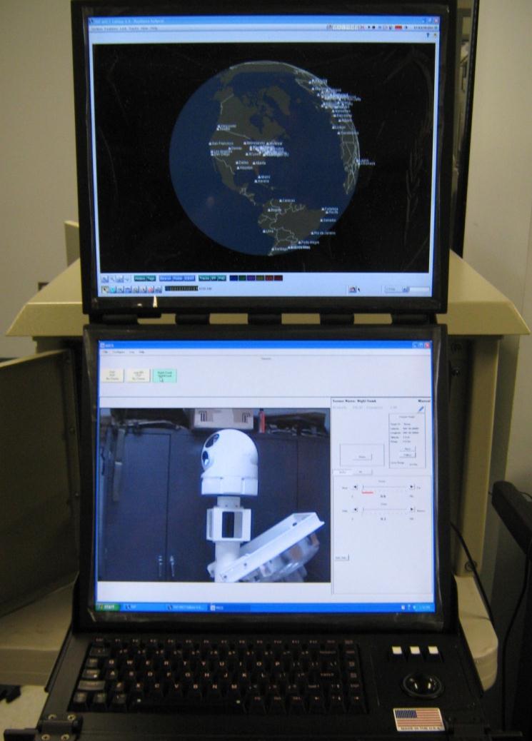
4 Advanced Radio Direction Finder (Series 7000 MPT) Integrates a DF processor and radio transceiver into a rugged modified Pelican case. Utilizing specialized antennas, the suite can quickly pinpoint VHF/UHF/THF signal locations from any combination of fixed or mobile configurations. The suite s software connects either directly or remotely via a network. The software provides results on an intuitive graphic interface based around a geospatial display combining audio collection, database, network communication, and receiver control at the operator s fingertips. Enhanced network operations enable signal collection using multiple sensors in various configurations either directly controlled or remotely operated to seamlessly communicate DF results in real-time to any computer on the network. ADVANTAGES Instantaneous target identification and geolocation via networked antennas Operates in many environments, from urban to austere; multiple mission configurations Easily converted from a mobile to fixed site; local or remote control; allows for unmanned sites and minimal staffing; monitors multiple frequencies with one antenna Rigorously engineered, calibrated and proven worldwide from the Baltic coastline to the mountains of Afghanistan DF Specifications DF Method: Pseudo-Doppler, Patented Smooth- Summing DF Coverage: 125* to 1000 MHz Bearing Accuracy: +/-1 RMS, Displayed in 0.1 increments Antenna Sensitivity: -123 dbm MPT Suite Size / Weight: 17 x11 x4 / 19 lbs MPT Suite Operating Temp: 0 C to 70 C Antenna Operating Temp: -25 C to 85 C Receiver Capabilities: Receiver Coverage: 25 MHz to 3 GHz Receiver Mode: NFM Additional Specifications: Input voltage: 12 VDC, ~0.6 amps* GUI Features Automated site frequency control across the entire network to include scan and search Real-time data from networked sites for automatic triangulation Target discrimination algorithms for multiple target identification Digital audio monitoring and recording for DF and additional receiver Database files with frequency, GPS, LOB, audio, DTMF and time Embedded transcript/reporting tool. Logging and playback options for review and auditing 4


5 Communication Systems & Network Services Smartphones Tablets Laptops Desktops CENTRA can provide a variety of integrated communications systems including fixed, mobile, terrestrial and satellite based communication systems engineered to our customer s needs. We specialize in providing secure, robust, highly configurable communications for permissive and non-permissive environments. In addition to mobile and fixed data transport systems, we can provide data storage, management and exploitation capabilities as well. We use a team of employees, consultants and mission partners with extensive experience operating and providing connectivity in difficult environments. Today, CENTRA Technology and our subsidiaries support over 200 network installations in 19 countries, providing reliable and secure communications to a variety of clients. Systems & Services Discriminating Factors Rapid technology insertion into austere, degraded environments Excellent network engineering teams Client focused Agile 24/7 worldwide customer support Secure Smartphone Systems Mobile Satellite Communications Fixed Satellite Data Transport & Storage Experienced smartphone systems integrator Voice, chat, & video over 3G, WiFi & satellite Chat & over 2G Push to Talk PTT functionality Map server with custom GIS data Command & control for multiple users Packaged turn-key secure fixed & mobile terrestrial and satellite based communication systems Thuraya Iridium NAL Research SBT Inmarsat BGAN Turn-key systems from sub 1 meter up to 3.6 meters Secure network management and data: transport, storage, management, visualization & exploitation capabilities 5


6 Unattended Ground Sensor Node Small, lightweight, adaptable, surveillance system for land forces Self-organizing, ad-hoc, secure wireless network communications 2.45 GHz Mesh-enabled network On-board and external sensors Radio Fence/ GPS/ Cameras/ Others Anti-tamper Four PIRs/ Accelerometer/ Magnetometer Standard interfaces and open data sharing standards for interoperability Rugged, power efficient, affordable Connected to a low bandwidth camera for TOI identification Alerts and images are relayed from the tripped node through the mesh network to a coordinator node and displayed on the monitoring software Tower-mounted optics can be slewed to focus on target area Useful for riverine and trail surveillance, high-density foliage environments RF Antenna External power connector 4 IR Motion detectors 360 deg. coverage 4 AA Battery compartment Lanyard attachment Radio Fence Feature Sentry Node Active GPS Antenna Serial and Analog Sensor interface connector Sealed toggle activate Thumbscrews for battery access The Radio Fence technology creates a trip-wire between nodes by continuously monitoring changes in the radio link signals The fence is triggered when a significant change in the radio link signal is detected indicating that something has passed between two nodes The detection between nodes is then reported to the user/collection point Allows long distance detection for perimeter security Operates at ranges between 50m to 100m clear-line-of-sight (CLOS) 6


7 Airborne MicroRAPTOR SAR/GMTI Radar All weather, day night wide area continuous synthetic aperture radar imaging and GMTI coverage from any small airborne platform Modular, expandable capture, processing and data storage architecture to support large area ISR missions High resolution SAR images can be generated across a 6km swath at up to 660 sq km per hour Enhances existing on board EO/IR camera capabilities by providing wide area radar surveillance cues Over 100x the search capability of EO/IR camera alone Open Architecture, Open Standard Design/Build (Non-Proprietary Interfaces and Data formats) Airborne Synthetic Aperture Radar (SAR) with Ground Moving Target Indication (GMTI) FEATURES & CAPABILITIES Detection/Tracking of vehicles out to 10+km Single Canopy FOPEN and coherent change detection (CCD) capable 7


 POP 300 EO/IR Sensor Combined electro-optic and infrared video sensor in")

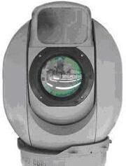
8 Intelligence, Surveillance, Reconnaissance (ISR) System Components ELM-2112 Multi-beam radar provides persistent ground surveillance and instantaneous target tracking over a wide area LCMR / LSTAR Radar L-band air defense radar adapted for detection and tracking of small low-flying UAVs A customizable mobile tower system for multiple ISR applications in remote areas Options include integrated air search/track radar, ground/coastal radar, EO/IR video sensors, track correlation software, communications, display and C2 Multiple cooperative towers linked by high speed data communications and controlled by a single command center or single tower Multi-threaded, modular, and expandable open architecture system External interfaces for two way real-time video and radar data sharing outside of tower network High-Bandwidth Wireless Data Link 108 Mbps (Range Dependent) Mobile Tower VZ-1000 Combined electro-optic and infrared video sensor in rugged gimbal mounted enclosure Operator Control Multi-Sensor Control System (MSCS) POP 300 EO/IR Sensor Combined electro-optic and infrared video sensor in rugged gimbal mounted enclosure FEATURES & CAPABILITIES Towers can be towed into place and erected to height of 80 ft in <30 min Self-contained or shore power Supports semi-automatic tower location, sensor orientation, and pointing of high speed intra-tower communications MSCS displays raw radar sensor tracks and/or correlated tracks from multiple radars (organic and external) 8

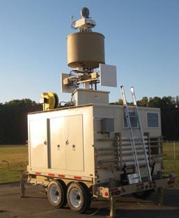
9 Integrated ISR Solution #1 Mobile Optical Radar Sensor System (MORSS) Modular ISR solution for the protection of airspace from UAVS or larger aircraft Delivers an automated, persistent wide-area airborne surveillance system with Common Operating Picture for monitoring airspace Detects, tracks, identifies, classifies airborne Targets of Interest and supports Automatic Target Identification Protection of airspace from Class II UAVS or larger aircraft Towers dispersed in pattern to protect form aircraft Each tower has EO/IR camera with airborne radar Towers auto-configure wireless communications can use any number for proper coverage Radar threats alert operator, Slew-to-Cue EO/IR capability from all towers Pedigree Mobile variants currently employed by DOD for the past 5 years Fixed tower variant in operation 24/7 by DHS for past 4 years Detect, track, and visually identify low flying, small aircraft in real-time at significant standoff ranges in challenging environments LCMR / LSTAR Radar L-band air defense radar adapted for detection and tracking of small low-flying UAVs POP 300 EO/IR Sensor Combined electro-optic and infrared video sensor in rugged gimbal mounted enclosure FEATURES Integrates COTS radars, camera systems, and 3rd party applications Can be utilized in fixed site or rapidly deployable mobile tower system EO/IR video sensor cueing in real time using correlated radar track picture generated by multiple radar correlator systems MORSS MORSS MORSS MSCS in Command Center 9


 each equipped with")
 Network")
 Command Operations Centers")
 Coverage can be enhanced by")
10 Integrated ISR Solution #2 Intelligent Border Surveillance Network (IBSN) Detect, track, and visually identify vehicles and personnel in real-time at significant standoff ranges in challenging environments EO/IR FOB National/Regional Watch Center COC Mobile RDF Fixed GCSP UGS Fixed RDF Fixed GCSP FOB Fixed RDF Mobile RDF UGS Mobile GCSP UGS UGS EO/IR 20 km EO/IR EO/IR 20 km IBSN includes Ground/Coastal Surveillance Platforms (GCSP) each equipped with a radar and thermal camera Radio Direction Finding (RDF) Network (UHF/VHF) Unattended Ground Sensors (UGS) Command Operations Centers (COC) and Field Operation Bases (FOB) Coverage can be enhanced by incorporating optional UAVs (new or existing aircraft) 40 km 10
11 International Products Catalog 2013 All of the products listed in this catalog and their associated training programs are fully exportable with the appropriate US ITAR or commercial export license. Any of these technologies can be acquired via US DoD foreign military sale (FMS) or by direct international commercial sale. Michael Townsend Program Manager, Special Technical Solutions CENTRA Technology, Inc. CENTRA Technology, Inc Wilson Blvd, Suite 302 Arlington, Virginia United States
720 VHF/UHF 80 to 500 MHz Maritime and Coastal Surveillance
 720 VHF/UHF 80 to 500 MHz Maritime and Coastal Surveillance Radio Direction Finding (RDF) System The TCI Model 720 is a high-performance radio direction finder that can be easily integrated into maritime
HALS-H1 Ground Surveillance & Targeting Helicopter
 ARATOS-SWISS Homeland Security AG & SMA PROGRESS, LLC HALS-H1 Ground Surveillance & Targeting Helicopter Defense, Emergency, Homeland Security (Border Patrol, Pipeline Monitoring)... Automatic detection
903S VHF/UHF Man-Portable COMINT System
 903S VHF/UHF Man-Portable COMINT System The TCI Model 903S is a compact, man-portable Communications Intelligence (COMINT) and direction finding (DF) system. At less than 40 Kg, it is ideal for two-man
DHS/U.S. Customs and Border Protection -
 DHS/U.S. Customs and Border Protection - Technology Solutions Program Office (TSPO) DHS/ Unmanned Aircraft System (UAS) October 31, 2006 1 Purpose Provide overall UAS program overview Program Description
Real-Time Spectrum Monitoring System Provides Superior Detection And Location Of Suspicious RF Traffic
 Real-Time Spectrum Monitoring System Provides Superior Detection And Location Of Suspicious RF Traffic By Malcolm Levy, Vice President, Americas, CRFS Inc., California INTRODUCTION TO RF SPECTRUM MONITORING
903S VHF/UHF/SHF Man-Portable COMINT System
 903S VHF/UHF/SHF Man-Portable COMINT System The TCI Model 903S is a compact, man-portable Communications Intelligence (COMINT) and direction finding (DF) system. At less than 40 Kg, it is ideal for two-man
Consultation Paper on Using a Portion of the Band GHz for Tactical Common Data Link (TCDL) Systems
 Systems") December 2008 Spectrum Management and Telecommunications Consultation Paper on Using a Portion of the Band 14.5-15.35 GHz for Tactical Common Data Link (TCDL) Systems Aussi disponible en français Department
December 2008 Spectrum Management and Telecommunications Consultation Paper on Using a Portion of the Band 14.5-15.35 GHz for Tactical Common Data Link (TCDL) Systems Aussi disponible en français Department
Targeting a Safer World
 Targeting a Safer World INTRODUCTION Accipiter Radar is a global provider of high performance radar surveillance solutions built upon its patented Radar Intelligence Network (RIN) Platform Technology.
723 Specialized 80 to 500 MHz Radio Direction Finding System For Airport Interference Detection
 723 Specialized 80 to 500 MHz Radio Direction Finding System For Airport Interference Detection The TCI Model 723 is a compact, high-performance radio direction finder that can be easily integrated into
Phantom Dome - Advanced Drone Detection and jamming system
 Phantom Dome - Advanced Drone Detection and jamming system *Picture for illustration only 1 1. The emanating threat of drones In recent years the threat of drones has become increasingly vivid to many
Discoverer II Space Based Radar Concept
 Discoverer II Space Based Radar Concept DARPATech 2000 Sept 2000 Allan Steinhardt Outline The Discoverer II Concept New Capabilities Active Electronic Scanned Antenna Space Based Information Processing
Wide-area Motion Imagery for Multi-INT Situational Awareness
 Wide-area Motion Imagery for Multi-INT Situational Awareness Bernard V. Brower Jason Baker Brian Wenink Harris Corporation TABLE OF CONTENTS ABSTRACT... 3 INTRODUCTION WAMI HISTORY... 4 WAMI Capabilities
737 LF/HF/VHF/UHF/SHF Spectrum Monitoring System
 737 LF/HF/VHF/UHF/SHF Spectrum Monitoring System The ITU-Compliant TCI Model 737 is the highest performance member of TCI s 700 series of fieldproven Spectrum Monitoring Systems (SMS), which addresses
Radar Systems.
 www.aselsan.com.tr Radar Systems With extensive radar heritage exceeding 20 years, ASELSAN is a new generation manufacturer of indigenous, state-ofthe-art radar systems. ASELSAN s radar product portfolio
Combining Ground Radars with Imaging Multisensors
 Combining Ground Radars with Imaging Multisensors FMV Sensors Symposium 2014 Anders GM Dahlberg Business Development Support & Key Account Manager anders.gm.dahlberg@flir.se Area surveillance day and night
RECONNAISSANCE PAYLOADS FOR RESPONSIVE SPACE
 3rd Responsive Space Conference RS3-2005-5004 RECONNAISSANCE PAYLOADS FOR RESPONSIVE SPACE Charles Cox Stanley Kishner Richard Whittlesey Goodrich Optical and Space Systems Division Danbury, CT Frederick
2006 CCRTS THE STATE OF THE ART AND THE STATE OF THE PRACTICE. Network on Target: Remotely Configured Adaptive Tactical Networks. C2 Experimentation
 2006 CCRTS THE STATE OF THE ART AND THE STATE OF THE PRACTICE Network on Target: Remotely Configured Adaptive Tactical Networks C2 Experimentation Alex Bordetsky Eugene Bourakov Center for Network Innovation
Cooperative navigation: outline
 Positioning and Navigation in GPS-challenged Environments: Cooperative Navigation Concept Dorota A Grejner-Brzezinska, Charles K Toth, Jong-Ki Lee and Xiankun Wang Satellite Positioning and Inertial Navigation
Wide-Area Motion Imagery for Multi-INT Situational Awareness
 Bernard V. Brower (U.S.) Jason Baker (U.S.) Brian Wenink (U.S.) Harris Corporation Harris Corporation Harris Corporation bbrower@harris.com JBAKER27@harris.com bwenink@harris.com 332 Initiative Drive 800
Mission Solution 300
 Mission Solution 300 Standard configuration for point defence Member of the Thales Mission Solution family Standard configuration of integrated sensors, effectors, CMS, communication system and navigation
KLEIN MARINE SYSTEMS, INC.
 Waterside Security System Concept Protection Requirements Constant monitoring of unattended waterside approaches to critical facilities Detect and identify vessels within the areas of interest surrounding
2012 PRODUCT INFORMATION SHEET. EagleEye 350 Multi-Role, Special Missions Aerial Surveillance Platform
 2012 PRODUCT INFORMATION SHEET EagleEye 350 Multi-Role, Special Missions Aerial Surveillance Platform The EagleEye 350 is a unique, highly-capable Airborne Multi-Role, Multi-Sensor, Special Missions -
MANNED AIRBORNE REAL-TIME SURVEILLANCE OBSERVATION SYSTEM
 MARSO WWW.MARSO.AERO MANNED AIRBORNE REAL-TIME SURVEILLANCE OBSERVATION & SYSTEM THE MARSO SYSTEM is a versatile surveillance system for a large class of missions ranging from large area ship detection
Special Projects Office. Mr. Lee R. Moyer Special Projects Office. DARPATech September 2000
 Mr. Lee R. Moyer DARPATech 2000 6-8 September 2000 1 CC&D Tactics Pose A Challenge to U.S. Targeting Systems The Challenge: Camouflage, Concealment and Deception techniques include: Masking: Foliage cover,
NETNode IP Mesh Overview. Audio and Video Products Cobham Tactical Communications & Surveillance
 NETNode IP Mesh Overview Audio and Video Products Cobham Tactical Communications & Surveillance NETNode IP MESH Radio NETNode IP Mesh Radio: The Performance of COFDM with the Flexibility of IP Enhanced
RFeye Arrays. Direction finding and geolocation systems
 RFeye Arrays Direction finding and geolocation systems Key features AOA, augmented TDOA and POA Fast, sensitive, very high POI of all signal types Capture independent of signal polarization Antenna modules
AIMS Radar Specifications
 Transmitted Frequency: Peak Radiated Power: Average Power: Antenna Beamwidth: 9.23 GHz 1 Watt (Optional 2 to 80 Watts) 6.25 microwatts up to 0.4 watts; < 1 milliwatt for most applications Fast-Scan (rotating):
NEXTMAP. P-Band. Airborne Radar Imaging Technology. Key Benefits & Features INTERMAP.COM. Answers Now
 INTERMAP.COM Answers Now NEXTMAP P-Band Airborne Radar Imaging Technology Intermap is proud to announce the latest advancement of their Synthetic Aperture Radar (SAR) imaging technology. Leveraging over
Wide Area Wireless Networked Navigators
 Wide Area Wireless Networked Navigators Dr. Norman Coleman, Ken Lam, George Papanagopoulos, Ketula Patel, and Ricky May US Army Armament Research, Development and Engineering Center Picatinny Arsenal,
BEYOND RADAR ERA MILITARY SOLUTIONS. Surveillance Reconnaissance Military ATM Command&Control Systems
 BEYOND RADAR ERA MILITARY SOLUTIONS Surveillance Reconnaissance Military ATM Command&Control Systems SEES WITHOUT BEING SEEN SENSORS SURVEILLANCE & RECONNAISSANCE VERA-NG Passive ESM Tracker VERA-NG addresses
RPAS & MANNED AIRCRAFT
 RPAS & MANNED AIRCRAFT Satcom Relay for Manned and Unmanned Airborne Platforms Unmanned aerial vehicles and manned aircrafts are increasingly being used as vehicles to capture intelligence data for defense,
Silent Sentry. Lockheed Martin Mission Systems. Jonathan Baniak Dr. Gregory Baker Ann Marie Cunningham Lorraine Martin.
 Silent Sentry Passive Surveillance Lockheed Martin Mission Systems Jonathan Baniak Dr. Gregory Baker Ann Marie Cunningham Lorraine Martin June 7, 1999 6/7/99 1 Contact: Lorraine Martin Telephone: (301)
Just how smart is your home?
 Just how smart is your home? A look at the features and benefits of LightwaveRF technology to control lighting, heating and security in your home. John Shermer Technology Choices Technology Choices Zigbee
HarborGuard-Pro. Integrated Maritime Security & Surveillance System
 HarborGuard-Pro Integrated Maritime Security & Surveillance System Klein Marine Systems, Inc. 11 Klein Drive, Salem, NH, USA 03079 Web: www.kleinmarinesystems.com This technical data and software is considered
Black Marlin radar systems may be purchased with a flat-top radome for mounting cameras on
 SPECIFICATIONS The Black Marlin is DMT s midrange security radar system. It may be used to search and track threats from land and sea. This radar is an X- Band, pulsed- Doppler system that operates in
Civil Radar Systems.
 Civil Radar Systems www.aselsan.com.tr Civil Radar Systems With extensive radar heritage exceeding 20 years, ASELSAN is a new generation manufacturer of indigenous, state-of-theart radar systems. ASELSAN
UNCLASSIFIED R-1 ITEM NOMENCLATURE FY 2013 OCO
 Exhibit R-2, RDT&E Budget Item Justification: PB 2013 Air Force DATE: February 2012 BA 3: Advanced Development (ATD) COST ($ in Millions) Program Element 75.103 74.009 64.557-64.557 61.690 67.075 54.973
Targeting a Safer World. Public Safety & Security
 Targeting a Safer World Public Safety & Security WORLD S MOST EFFECTIVE AND AFFORDABLE WIDE-AREA SITUATIONAL AWARENESS Accipiter provides the world s most effective and affordable wide-area situational
Dynamic Sciences International, Inc. Detection with Direction
 Dynamic Sciences International, Inc Detection with Direction CORPORATE OVERVIEW WHO WE ARE Dynamic Sciences International, Inc. (DSII) is a public corporation Serving customers worldwide since 1972. DSII
Jager UAVs to Locate GPS Interference
 JIFX 16-1 2-6 November 2015 Camp Roberts, CA Jager UAVs to Locate GPS Interference Stanford GPS Research Laboratory and the Stanford Intelligent Systems Lab Principal Investigator: Sherman Lo, PhD Area
BORDER CONTROL SUMMARY
 BORDER CONTROL BORDER CONTROL The protection of homeland territory requires the capability to secure national borders in both the land and maritime domains. Assuring borderline security, denying illegal
Channel Emulation Solution
 PROPSIM MANET Channel Emulation Solution SOLUTION BRIEF Mission Critical Communications Secured Highly Scalable Channel Emulation Solution for MANET and Mesh Radio Testing. The need for robust wireless
DEFENCE AND SPACE Security Solutions. STYRIS Coastal Surveillance Systems
 DEFENCE AND SPACE Security Solutions STYRIS Coastal Surveillance Systems Enforcing Border Integrity Maritime Domain Awareness through the provision of: Advanced Radar Processing for small targets Multi
Countering Weapons of Mass Destruction (CWMD) Capability Assessment Event (CAE)
 Capability Assessment Event (CAE)") Countering Weapons of Mass Destruction (CWMD) Capability Assessment Event (CAE) Overview 08-09 May 2019 Submit NLT 22 March On 08-09 May, SOFWERX, in collaboration with United States Special Operations
Countering Weapons of Mass Destruction (CWMD) Capability Assessment Event (CAE) Overview 08-09 May 2019 Submit NLT 22 March On 08-09 May, SOFWERX, in collaboration with United States Special Operations
Marine Monitor (M ) A Low Cost Radar Solution for Monitoring Nearshore Marine Protected Areas
 A Low Cost Radar Solution for Monitoring Nearshore Marine Protected Areas") 2 Marine Monitor (M ) A Low Cost Radar Solution for Monitoring Nearshore Marine Protected Areas 1 Problem The number of Marine Protected Areas (MPAs) are increasing globally making it challenging to effectively
2 Marine Monitor (M ) A Low Cost Radar Solution for Monitoring Nearshore Marine Protected Areas 1 Problem The number of Marine Protected Areas (MPAs) are increasing globally making it challenging to effectively
Integrated Microwave Assembly & Subsystem Solutions
 RF & microwave signal conditioning and electromagnetic spectrum management solutions, from components to complete subsystems. Integrated Microwave Assembly & Subsystem Solutions Integrated Microwave Assembly
Copyright 2016 Raytheon Company. All rights reserved. Customer Success Is Our Mission is a registered trademark of Raytheon Company.
 Make in India Paradigm : Roadmap for a Future Ready Naval Force Session 9: Coastal Surveillance, Response Systems and Platforms Nik Khanna, President, India April 19, 2016 "RAYTHEON PROPRIETARY DATA THIS
Hyper-spectral, UHD imaging NANO-SAT formations or HAPS to detect, identify, geolocate and track; CBRN gases, fuel vapors and other substances
 Hyper-spectral, UHD imaging NANO-SAT formations or HAPS to detect, identify, geolocate and track; CBRN gases, fuel vapors and other substances Arnold Kravitz 8/3/2018 Patent Pending US/62544811 1 HSI and
An Introduction to Airline Communication Types
 AN INTEL COMPANY An Introduction to Airline Communication Types By Chip Downing, Senior Director, Aerospace & Defense WHEN IT MATTERS, IT RUNS ON WIND RIVER EXECUTIVE SUMMARY Today s global airliners use
Fire Fighter Location Tracking & Status Monitoring Performance Requirements
 Fire Fighter Location Tracking & Status Monitoring Performance Requirements John A. Orr and David Cyganski orr@wpi.edu, cyganski@wpi.edu Electrical and Computer Engineering Department Worcester Polytechnic
INNOVATIVE SPECTRAL IMAGING
 INNOVATIVE SPECTRAL IMAGING food inspection precision agriculture remote sensing defense & reconnaissance advanced machine vision product overview INNOVATIVE SPECTRAL IMAGING Innovative diffractive optics
RFeye Node. Wideband intelligent spectrum system for remote distributed RF monitoring
 RFeye Node Wideband intelligent spectrum system for remote distributed RF monitoring Key features 6 GHz standard and 18 GHz frequency DF and geolocation capable extender Multiple RF ports for multi-antenna
DRS Signal Solutions. Capabilities and Product Overview. February 2014 Condensed Version
 DRS Signal Solutions Capabilities and Product Overview February 2014 Condensed Version Information included herein has been determined to not contain any controlled technical data or technology as these
MR-i. Hyperspectral Imaging FT-Spectroradiometers Radiometric Accuracy for Infrared Signature Measurements
 MR-i Hyperspectral Imaging FT-Spectroradiometers Radiometric Accuracy for Infrared Signature Measurements FT-IR Spectroradiometry Applications Spectroradiometry applications From scientific research to
Future Soldier Countering Emerging/Future Threats 3D RADAR MULTI-SENSOR by Weibel/CST proprietary 1
 Future Soldier Countering Emerging/Future Threats 3D RADAR MULTI-SENSOR by 2018-05-23 Weibel/CST proprietary 1 AUTHORITIES CHALLENGES Increasing number of intrusions on critical infrastructures, prisons,
MR-i. Hyperspectral Imaging FT-Spectroradiometers Radiometric Accuracy for Infrared Signature Measurements
 MR-i Hyperspectral Imaging FT-Spectroradiometers Radiometric Accuracy for Infrared Signature Measurements FT-IR Spectroradiometry Applications Spectroradiometry applications From scientific research to
39N6E KASTA-2E2 Low-Altitude 3D All-Round Surveillance Radar
 39N6E KASTA-2E2 Low-Altitude 3D All-Round Surveillance Radar The Kasta-2E2 low-altitude 3D all-round surveillance radar is designed to control airspace and to perform automatic detection, range/azimuth/altitude
Improving Performance through Superior Innovative Antenna Technologies
 Improving Performance through Superior Innovative Antenna Technologies INTRODUCTION: Cell phones have evolved into smart devices and it is these smart devices that have become such a dangerous weapon of
SMART CARPET A DISTRIBUTED COGNITIVE RADIO
 SMART CARPET A DISTRIBUTED COGNITIVE RADIO Topic Session: 6.11 Stephen P. Reichhart (Air Force Research Laboratory) (AFRL/IFGC, 525 Brooks Road, Rome, NY 13441) (Phone: 315 330-3918, Fax: 315 330-3908)
2006 CCRTS THE STATE OF THE ART AND THE STATE OF THE PRACTICE. Network on Target: Remotely Configured Adaptive Tactical Networks. C2 Experimentation
 2006 CCRTS THE STATE OF THE ART AND THE STATE OF THE PRACTICE Network on Target: Remotely Configured Adaptive Tactical Networks C2 Experimentation Alex Bordetsky Eugene Bourakov Center for Network Innovation
Model-Based Design for Sensor Systems
 2009 The MathWorks, Inc. Model-Based Design for Sensor Systems Stephanie Kwan Applications Engineer Agenda Sensor Systems Overview System Level Design Challenges Components of Sensor Systems Sensor Characterization
HTZ warfare MILITARY COMMUNICATION NETWORKS TECHNICAL SPECTRUM MANAGEMENT THE REFERENCE TOOL FOR ELECTRONIC WARFARE & TACTICAL COMMUNICATIONS
 THE REFERENCE TOOL FOR ELECTRONIC WARFARE & TACTICAL COMMUNICATIONS MILITARY COMMUNICATION NETWORKS ACCURATE BATTLEFIELD SIMULATION TECHNICAL SPECTRUM MANAGEMENT the most comprehensive radio planning solution
Deploy Quicker, Produce Faster. Agilent E3238 Signal Intercept and Collection Solutions Family Overview International Edition
 Deploy Quicker, Produce Faster Agilent E3238 Signal Intercept and Collection Solutions Family Overview International Edition Agilent E3238 Family of Signal Intercept and Collection Solutions Explosive
NET SENTRIC SURVEILLANCE BAA Questions and Answers 2 April 2007
 NET SENTRIC SURVEILLANCE Questions and Answers 2 April 2007 Question #1: Should we consider only active RF sensing (radar) or also passive (for detection/localization of RF sources, or using transmitters
BLACK MARLIN Specification SPECIFICATIONS. Black Marlin radar systems may be purchased with a flattop radome for mounting
 Black Marlin radar systems may be purchased with a flattop radome for mounting cameras on top. This gives 360 degrees of coverage for both the radar and camera. SPECIFICATIONS The Black Marlin is DMT s
A New Generation Tracking and Exploitation System
 B-08 JIFX 16-1 2-6 November 2015 Camp Roberts, CA A New Generation Tracking and Exploitation System Cyclops Technologies Principal Investigator: David Breville Area of Interest: Location, Tracking and
model 802C HF Wideband Direction Finding System 802C
 model 802C HF Wideband Direction Finding System 802C Complete HF COMINT platform that provides direction finding and signal collection capabilities in a single integrated solution Wideband signal detection,
APPENDIX H PRICE WORKSHEETS, REVISED 12/26/15 1. BATTERIES, MODULAR FLOODED LEAD-ACID 2. BATTERIES, MODULAR VALVE REGULATED LEAD ACID
 APPENDIX H PRICE WORKSHEETS, REVISED 12/26/15 BIDDER INSTRUCTIONS: All Bidder pricing must be based on the Sample Product provided in Appendix H Mandatory Requirements. Any category in Appendix H that
Advances in Digital Receiver Technology
 Andreas Radermacher February 2017 Advances in Digital Receiver Technology Raytheon Proprietary/Business Data This document contains proprietary business data or information pertaining to items, components,
Introduction Objective and Scope p. 1 Generic Requirements p. 2 Basic Requirements p. 3 Surveillance System p. 3 Content of the Book p.
 Preface p. xi Acknowledgments p. xvii Introduction Objective and Scope p. 1 Generic Requirements p. 2 Basic Requirements p. 3 Surveillance System p. 3 Content of the Book p. 4 References p. 6 Maritime
Coastal Surveillance. SCANTER Radar Solutions
 Coastal Surveillance SCANTER Radar Solutions Protecting Your Coastlines and Maritime Domain We provide radar coverage of the coastline to detect and track all types of surface vessels and air targets.
DEFENSE and SECURITY RIGEL ES AND. Defense and security in five continents. indracompany.com
 DEFENSE and SECURITY RIGEL ES AND EA Systems Defense and security in five continents indracompany.com RIGEL ES EA Systems RIGEL ES AND EA Systems RIGEL ES System The Naval Radar ES and EA systems provide
Reprint (R43) Polarmetric and Hyperspectral Imaging for Detection of Camouflaged Objects. Gooch & Housego. June 2009
 Polarmetric and Hyperspectral Imaging for Detection of Camouflaged Objects. Gooch & Housego. June 2009") Reprint (R43) Polarmetric and Hyperspectral Imaging for Detection of Camouflaged Objects Gooch & Housego June 2009 Gooch & Housego 4632 36 th Street, Orlando, FL 32811 Tel: 1 407 422 3171 Fax: 1 407 648
Reprint (R43) Polarmetric and Hyperspectral Imaging for Detection of Camouflaged Objects Gooch & Housego June 2009 Gooch & Housego 4632 36 th Street, Orlando, FL 32811 Tel: 1 407 422 3171 Fax: 1 407 648
Mission Solution 100
 Mission Solution 100 Standard configuration for littoral security Member of the Thales Mission Solution family Standard configuration of integrated sensors, effectors, CMS, communication system and navigation
Sang-Tae Kim, Seong-Yun Lee. Radio Technology Research Department
 Trends and Technology Of Radio Monitoring In Korea Sang-Tae Kim, Seong-Yun Lee Radio Technology Research Department 1 Contents I Trends of Radio Monitoring II Design Concepts of Radio Monitoring System
SOLUTIONS Paper Wi4 Fixed: Point-to-Point Wireless Broadband Solutions. Point-to-Point Connectivity in the 4.9 GHz Public Safety Band
 SOLUTIONS Paper Wi4 Fixed: Point-to-Point Wireless Broadband Solutions Point-to-Point Connectivity in the 4.9 GHz Public Safety Band Contents pg Section 3 FCC and the Public Safety RF Band 3 Qualified
KCS MULTI-FUNCTIONAL SENSOR NETWORK MANAGEMENT
 KCS MULTI-FUNCTIONAL SENSOR NETWORK MANAGEMENT KCS KEY FEATURES The KCS is a solution for the organisation, configuration, and monitoring of sensors. It embeds sensors for the detection, identification,
UAV + Onboard Pilot = enhanced performance Light Aircraft?
 Royal Aeronautical Society Light Aircraft Design: Methods and Tools 2014 17 November, 2014 UAV + Onboard Pilot = enhanced performance Light Aircraft? Dr Joseph Barnard joseph.barnard@barnardmicrosystems.com
AFRL. Technology Directorates AFRL
 Sensors Directorate and ATR Overview for Integrated Fusion, Performance Prediction, and Sensor Management for ATE MURI 21 July 2006 Lori Westerkamp Sensor ATR Technology Division Sensors Directorate Air
PEGASUS : a future tool for providing near real-time high resolution data for disaster management. Lewyckyj Nicolas
 PEGASUS : a future tool for providing near real-time high resolution data for disaster management Lewyckyj Nicolas nicolas.lewyckyj@vito.be http://www.pegasus4europe.com Overview Vito in a nutshell GI
IRIS PRODUCT LINE AND DATA INFORMATION
 PRODUCT LINE AND DATA INFORMATION IRIS I I I I I I I I I I I I I I I I I I I I I I I I I I I I I I I I I I I I I I I I I I I I I I I I I I I I I I I I I I I I I I I I I I I I I I I I I I I I I I I I I
Mini Market Study Report August 2011
 Naval Surface Warfare Center (NAVSEA) Crane Division Two Band Imaging System (US Patent No. 6,969,856) Mini Market Study Report August 2011 Sponsored by: Integrated Technology Transfer Network, California
Customer Showcase > Defense and Intelligence
 Customer Showcase Skyline TerraExplorer is a critical visualization technology broadly deployed in defense and intelligence, public safety and security, 3D geoportals, and urban planning markets. It fuses
The EDA SUM Project. Surveillance in an Urban environment using Mobile sensors. 2012, September 13 th - FMV SENSORS SYMPOSIUM 2012
 Surveillance in an Urban environment using Mobile sensors 2012, September 13 th - FMV SENSORS SYMPOSIUM 2012 TABLE OF CONTENTS European Defence Agency Supported Project 1. SUM Project Description. 2. Subsystems
Networked Targeting Technology
 Networked Targeting Technology Stephen Welby Next Generation Time Critical Targeting Future Battlespace Dominance Requires the Ability to Hold Opposing Forces at Risk: At Any Time In Any Weather Fixed,
Robust Wideband Waveforms for Synthetic Aperture Radar (SAR) and Ground Moving Target Indication (GMTI) Applications
 and Ground Moving Target Indication (GMTI) Applications") Robust Wideband Waveforms for Synthetic Aperture Radar (SAR) and Ground Moving Target Indication (GMTI) Applications DARPA SBIR Topic: SB82-2, Phase II Army Contract W31P4Q-11-C-43 Program Summary September
Robust Wideband Waveforms for Synthetic Aperture Radar (SAR) and Ground Moving Target Indication (GMTI) Applications DARPA SBIR Topic: SB82-2, Phase II Army Contract W31P4Q-11-C-43 Program Summary September
Realtime Airborne Imagery for Emergency GIS Applications
 Realtime Airborne Imagery for Emergency GIS Applications Demonstration and Evaluation with Monroe County Office of Emergency Management August - September 2010 Information Products Laboratory for Emergency
USE OF IMPROVISED REMOTELY SENSED DATA FROM UAV FOR GIS AND MAPPING, A CASE STUDY OF GOMA CITY, DR CONGO
 USE OF IMPROVISED REMOTELY SENSED DATA FROM UAV FOR GIS AND MAPPING, A CASE STUDY OF GOMA CITY, DR CONGO Cung Chin Thang United Nations Global Support Center, Brindisi, Italy, Email: thang@un.org KEY WORDS:
ILA Berlin Air Show 2016
 http://www.tencate.com/emea/images/milipol_paris_201328-2402328-25603.jpgv ILA Berlin Air Show 2016 Dear Customers and Business Partners, June 1 to 4, 2016 Berlin ExpoCenter Airport Hall 2, booth 319 The
BATS WIRELESS. Electronically Steered Antenna (ESA) Omni Antenna. Sector Antenna. High Gain High Mobility Hi Reliability
 Omni Antenna. Sector Antenna. High Gain High Mobility Hi Reliability") BATS WIRELESS High Gain High Mobility Hi Reliability Omni Antenna Omni antennas have been predominately used in mobile communications for their ease of use. Ease of use has provided no protection from
BATS WIRELESS High Gain High Mobility Hi Reliability Omni Antenna Omni antennas have been predominately used in mobile communications for their ease of use. Ease of use has provided no protection from
A Hybrid Indoor Tracking System for First Responders
 A Hybrid Indoor Tracking System for First Responders Precision Indoor Personnel Location and Tracking for Emergency Responders Technology Workshop August 4, 2009 Marc Harlacher Director, Location Solutions
TRINITY Standard configuration for littoral defence
 Standard configuration for littoral defence Member of the Thales Mission Solution family Unrivalled tracking and fire control solution for small manoeuvring targets Innovative approach and easy to install
LUXEMBOURG AND KLEOS COOPERATION WITHIN THE SPACERESOURCES.LU INITIATIVE CONFÉRENCE DE PRESSE. 24 juillet 2017
 LUXEMBOURG AND KLEOS COOPERATION WITHIN THE SPACERESOURCES.LU INITIATIVE CONFÉRENCE DE PRESSE 24 juillet 2017 Video Intro https://vimeo.com/212878439 Introduction UK based, Space engineering services for
IMAGE FORMATION THROUGH WALLS USING A DISTRIBUTED RADAR SENSOR NETWORK. CIS Industrial Associates Meeting 12 May, 2004 AKELA
 IMAGE FORMATION THROUGH WALLS USING A DISTRIBUTED RADAR SENSOR NETWORK CIS Industrial Associates Meeting 12 May, 2004 THROUGH THE WALL SURVEILLANCE IS AN IMPORTANT PROBLEM Domestic law enforcement and
Communicator II WIRELESS DATA TRANSCEIVER
 Communicator II WIRELESS DATA TRANSCEIVER C O M M U N I C A T O R I I The Communicator II is a high performance wireless data transceiver designed for industrial serial and serial to IP networks. The Communicator
Leadership built upon facts Cobham SATCOM Maritime communication solutions
 Friday, 10 April 2015 The most important thing we build is trust MARINE FleetBroadband VSAT solutions Satellite TV GMDSS VHF and MF/HF radios AIS, Navtex LAND BGAN Portable and Vehicular terminals VSAT
UAV CRAFT CRAFT CUSTOMIZABLE SIMULATOR
 CRAFT UAV CRAFT CUSTOMIZABLE SIMULATOR Customizable, modular UAV simulator designed to adapt, evolve, and deliver. The UAV CRAFT customizable Unmanned Aircraft Vehicle (UAV) simulator s design is based
Pharovision, LLC E FM 1097 Willis, Texas United States Tel. (936) , Fax. (936)
 , Fax. (936)") 1 General Interceptor Bird Detection System White Paper June 1, 2015 The Pharovision INTERCEPTOR bird detection system automatically detects individual birds and flocks of birds, day or night, using an
1 General Interceptor Bird Detection System White Paper June 1, 2015 The Pharovision INTERCEPTOR bird detection system automatically detects individual birds and flocks of birds, day or night, using an
New and Emerging Technologies
 New and Emerging Technologies Edwin E. Herricks University of Illinois Center of Excellence for Airport Technology (CEAT) Airport Safety Management Program (ASMP) Reality Check! There are no new basic
MULTI-MODE MULTI MISSION RADAR
 MULTI-MODE MULTI MISSION RADAR leonardocompany.com For more information please email infomarketing@leonardocompany.com Leonardo S.p.a. Via Tiburtina, Km 12.400-00131 Rome - Italy - Tel: +39 06 41501 -