Navigation and communication systems for autonomous ships
|
|
|
- Jennifer Watkins
- 5 years ago
- Views:
Transcription
1 1 2h Navigation and communication systems for autonomous ships 15 June 2017 Egil Eide Associate professor Radio Systems Department of Electronics Systems 1. Sensors for autonomous ships 2. LIDAR and Radar 3. Land based Radar network 4. Communication systems 5. Massive MIMO 6. Autonomous ferry project


2 2 Nikola Tesla demonstrated radio controlled boat i 1898 Century Magazine 1900: - Tesla believed that one day we may be able to endow a machine with its "own mind," where it can act on environmental stimuli of its own accord.
3 3 Sensors for autonomous ships Navigation sensors - GNSS - GNSS Compass - INS (MRU) Anti-collision sensors - Radar - Camera (visible plus IR) - Lidar Instrumentation - motors, batteries - monitoring Kongsberg Seapath
4 4 Lidar (Velodyne VLP-16) High update rata 16 parallel beams in the vertival plane +/- 15 deg Range 100 meter Law power consumption 8 Watt, 830 gram 3D-360 degree LIDAR (903 nm) Class 1 Eye-safe 5 20 Hz rpm ( points/sec) +/- 3cm range, 0.1deg Azimuth, 0.4 deg Elevation Sea clutter performance is still to be analyzed

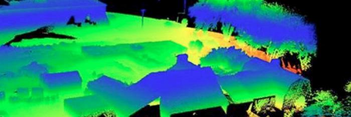
5 5 Example LIDAR data
6 6 Multi-channel laser for scanning LIDAR MEMS scanning LIDAR Field of view: 120deg Az, 20deg El Peak power 85 W Pulse length: 5 20ns Range: 300 meter (car) 70 meter (pedestrian) Angular accuracy: deg Osram Semiconductor 4-Channel LIDAR


7 7 Short range radar RfBeam 24 GHz radar 24 GHz Ka band GHz 76 GHz automotive FMCW and Doppler Radar Bandwidth 250 MHz 4 GHz Beamwidth: 7 80 degrees Range: meter


8 8 122 GHz mmw Radar
 =")
9 9 Radar Well proven technology Long range Limited resolution r c 2B Sea clutter rain clutter operator errors «Radar holes» due to multipath during calm sea ARPA only for large installations Small ships does not have ARPA «Blind zone» 25m at short ranges Low update rate ( updates/sec) =
10 10 Sea clutter Dependent on wind and sea state Directional clutter response May mask small objects
11 11 Rain clutter Highest clutter level at X- band ( GHz)


12 12 Detection and tracking of small objects Image: Navico
13 13 Radar network Broadcast ARPA processor Several radars cover a common area from different angles Sensor fusion on raw data or post detection data Centralized ARPA function with high quality Broadcasting of tracks to all user in the area Augmented AIS
14 14 Radar network in the Trondheim Fjord (proposal) 6 nm range VDES? 4G BROADCAST 3 nm range Hub Multi-frame ARPA processor
15 15 Advantages Stationary radars Solid state coherent radar (Chirp/FMCW) with Doppler filtering More suitable antenna patterns less rain clutter Observations from many angles reduction of sea clutter Combined S + X band processing ( GHz) ( GHz) Sensor fusion at raw data level Processed tracks can be broadcasted with low data rate
 Raw data transfer: 50 Mbit/s PPI transfer: 0.")
16 16 Technological challenges High capacity low latency data transfer from radar to central Fast multi-frame processing of large amounts of data Low total latency: < 1 sec (from recording to distributed tracks) Raw data transfer: 50 Mbit/s PPI transfer: 0.3 Mbit/s Broadcasting of tracks: 50bytes/track
17 17 Operational advantages Augmented AIS full ARPA functionality even for small vessels Tracking of small objects (small boats, kayaks etc) High reliability detection Avoid shadows behind headlands VTS functionality Better safety on sea Less risk of accidets
18 18 Autonomous ships and communication Need secure and robust communications system Authentication and encryption (resilient against hacking) Redundancy: several frequency bands several systems Correction data for GNSS (RTK) Commands from shore station (VTS) Narrowband telemetry (AIS - VDS) status updates Ship ship communication (collaborative navigation) Broadband telemetry, video, radar, lidar Voice relay (maritime VHF) Remote control during docking operations
 2 VHF")
")
19 19 VDES (VHF Data Exchange System) 2 VHF channels (25 khz) QPSK 156 kbit/s (shared) ITU-R M
20 20 Broadband Radio: Kongsberg Maritime Broadband Radio (5 GHz band) adaptive beamforming up to 60 antennas in an array
21 21 Autentication TDOA (Time Difference of Arrival) GNSS Timing Rx SDR SDR GNSS Timing Rx 15ns (1sigma) GNSS Timing Rx SDR 15ns (1sigma)


22 22 Radar +TDOA Radar +TDOA Radar +TDOA
23 23 LTE, WIFI and 5G Massive MIMO Communications in Maritime Propagation Environments MaMIME How to Make This Work in a Maritime Scenario Understand propagation Continue activity on channel modeling Antennas Large arrays Spatially distributed Measurement campaign From shore to ship Partners NTNU Kongsberg Seatex Teleplan Witelcom ZTE Super Radio
24 24 ReRaNP Reconfigurable Radio Network Platform "All the proof of a pudding is in the eating." Enabling research infrastructure for exploration validation demonstration of the next generation of radio systems Implement and test in environments of Norwegian interest Large cells, rural regions Maritime and Arctic environments
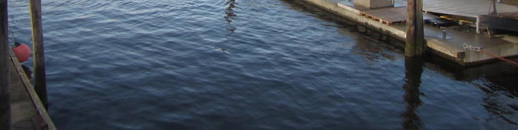
25 25 What is the Reconfigurable Radio Network Platform? National infrastructure project Funded by the Research Council of Norway A Software Defined Radio (SDR) lab Massive MIMO capabilities at NTNU o 64 SDR units in a rack give a BS with 128 antennas o 4 racks with 16 SDR units each gives 4 BS with 32 antennas o 5G demonstrator Roof-lab with 4 sites provided by Wireless Trondheim o 4 BS with 32 antennas each o 5G demonstrator in city environment
26 26 The SDR in ReRaNP NI USRP-2943R 64 units in racks 40MHz BW 1.2 GHz TO 6 GHz Kintex-7 FPGA PXI Express GPS disciplined oscillators NI USRP-2953R As nodes (7 units) Same as above with inbuilt GPS Clock PHY programmed with LabVIEW Communications System Design Suite GNU Radio
27 27 Antenna array Log-periodic antenna elements Gain 6 dbi Array made of 4 sub-arrays 32 elements in a 4x8 grid One array for the frequency range from 1.4-6GHz


28 28 Department of Electronics Systems Department of Engineering Cybernetics Department of Marine Technology Concept Illustration: Svein Aa Aanondsen, NTNU On-demand ferry - push the button for the ferry to come Traveling time: 1 minute low latency Passengers: 12 persons Electrical propulsion, Automatic charging of batteries Navigation: RTK GNSS compass with IMU plus backup system Anti-collision system (Lidar/camera/radar)


29 29 A new entrance for cruise tourists


30 30 New bridge for pedestrians


31 31 Illustration: Anders Engebakken, NTNU


32 32 Automatic docking and passenger access system Passenger registration using smartphone app On board camera + IR for verification Fail-safe gate sytem Illustration: Anders Engebakken, NTNU
33 33 Fase Phase 3: 3: Fullskala Scale ferge Ferry (2019) Size: L: 8 10m x W: 3.5 4m 12 passengers Automatic battery charging (induction or plug connector) Propulsion: 2 x 10kW azimuth thrusters RTK GNSS-compass + LIDAR system AIS and 2-way wireless communication including video
34 34 The Autosea project Courtesy: Edmund Førland Brekke, NTNU

35 35 The AUTOSEA project Funded under the MAROFF programme of the Research Council of Norway. Budget 11MNOK, with contributions from DNV GL, Kongsberg Maritime and Maritime Robotics. Duration: August 2015-Spring Competence building project: The aim is to educate PhDs with expertise on maritime collision avoidance. The project funds 2 PhD candidates and one postdoctoral fellow. In addition, 2 PhD candidates and several MSc candidates are affiliated with the project. Project is owned by the Department of Engineering Cybernetics at NTNU.
36 36 Photo: Egil Eide Time schedule Phase 1 (2016): Concept study, student projects. Webcamera and radar to monitor boat traffic i the harbour. Dynamic Position system to be tested onboard ReVolt from DNV-GL in Trondheim Harbour. Phase 2 (2017): Autonomous pilot ferry for concept testing and to study behaviour of the other boat traffic. Phase 3 (2018/2019): Full scale ferry certified for passengers.
 Photo: Egil Eide Radar +")

37 37 Phase 1: Monitoring of boat traffic (Collaboration with Maritime Robotics) Photo: Egil Eide Radar + webcam Image: Maritime Robotics boat traffic statistics kayaks and small wooden boats study behaviour of boaters


 Field of")
38 38 Phase 1: Monitoring of boat traffic (Collaboration with Maritime Robotics) Field of view Radar and webcamera
39 39 Photo: Egil Eide
Maritime Electronics Supporting Unmanned Vessels
 EU-Japan Policy Workshop Maritime Electronics Supporting Unmanned Vessels November 11 th, 2016 TAKUO KASHIWA, Ph.D Furuno Electric Co., Ltd. Agenda Positioning Technologies for Vessel s position Technologies
Author s Name Name of the Paper Session. DYNAMIC POSITIONING CONFERENCE October 10-11, 2017 SENSORS SESSION. Sensing Autonomy.
 Author s Name Name of the Paper Session DYNAMIC POSITIONING CONFERENCE October 10-11, 2017 SENSORS SESSION Sensing Autonomy By Arne Rinnan Kongsberg Seatex AS Abstract A certain level of autonomy is already
Vehicle-to-X communication using millimeter waves
 Infrastructure Person Vehicle 5G Slides Robert W. Heath Jr. (2016) Vehicle-to-X communication using millimeter waves Professor Robert W. Heath Jr., PhD, PE mmwave Wireless Networking and Communications
TECHNOLOGY DEVELOPMENT AREAS IN AAWA
 TECHNOLOGY DEVELOPMENT AREAS IN AAWA Technologies for realizing remote and autonomous ships exist. The task is to find the optimum way to combine them reliably and cost effecticely. Ship state definition
S a t e l l i t e T i m e a n d L o c a t i o n. N o v e m b e r John Fischer VP Advanced R&D
 STL - S a t e l l i t e T i m e a n d L o c a t i o n N o v e m b e r 2 0 1 7 John Fischer VP Advanced R&D jfischer@orolia.com 11/28/201 1 7 WHY AUGMENT GNSS? Recent UK Study Economic Input to UK of a
MMW sensors for Industrial, safety, Traffic and security applications
 MMW sensors for Industrial, safety, Traffic and security applications Philip Avery Director, Navtech Radar Ltd. Overview Introduction to Navtech Radar and what we do. A brief explanation of how FMCW radars
FURUNO DEEPSEA WORLD Class-A Universal AIS Automatic Identification System. The future today with FURUNO's electronics technology.
 R FURUNO DEEPSEA WORLD Class-A Universal AIS Automatic Identification System Model FA-100 The AIS improves the safety of navigation by assisting in the efficient navigation of ships, protection of the
Advances in RF and Microwave Measurement Technology
 1 Advances in RF and Microwave Measurement Technology Farris Alhorr Business Development Manager RF & Wireless Communication Farris.alhorr@ New Demands in Modern RF and Microwave Test In semiconductor
Absolute Positioning by Radar
 Absolute Positioning by Radar Dr Nick Ward, Research Director General Lighthouse Authorities of UK & Ireland 14th IAIN Congress 2012, 01-03 October, 2012 - Cairo, Egypt Seamless Navigation (Challenges
Simrad R5000 IMO/Solas Type Approved Radar Systems
 Simrad R5000 IMO/Solas Type Approved Radar Systems R5000 www.navico.com/commercial R5000 Radar Systems SIMRAD R5000 Radar Systems feature a modular plug & play design making it easy to create a cost effective
Vehicle-to-X communication for 5G - a killer application of millimeter wave
 2017, Robert W. W. Heath Jr. Jr. Vehicle-to-X communication for 5G - a killer application of millimeter wave Professor Robert W. Heath Jr. Wireless Networking and Communications Group Department of Electrical
COMMUNICATIONS FOR MARITIME SAFETY AND EFFICIENCY. Francis Zachariae, Secretary-General, IALA
 COMMUNICATIONS FOR MARITIME SAFETY AND EFFICIENCY Francis Zachariae, Secretary-General, IALA IALA and its Purpose Non profit, international technical association established in 1957 Two Goals aimed at
DURIP Distributed SDR testbed for Collaborative Research. Wednesday, November 19, 14
 DURIP Distributed SDR testbed for Collaborative Research Distributed Software Defined Radar Testbed Collaborative research resource based on software defined radar (SDR) platforms that can adaptively modify
Wide-Area Persistent Energy-Efficient Maritime Sensing
 DISTRIBUTION STATEMENT A. Approved for public release; distribution is unlimited. Wide-Area Persistent Energy-Efficient Maritime Sensing Robert Calderbank, Principal Investigator Matthew Reynolds, Co-Principal
A new Modular and Open Concept for the Maritime Integrated PNT System
 A new Modular and Open Concept for the Maritime Integrated PNT System T. Noack German Aerospace Center Institute of Communications and Navigation www.dlr.de Chart 2 MTS-2012 Maritime Integrated PNT Unit
Cooperative navigation (part II)
") Cooperative navigation (part II) An example using foot-mounted INS and UWB-transceivers Jouni Rantakokko Aim Increased accuracy during long-term operations in GNSS-challenged environments for - First responders
Cooperative navigation (part II) An example using foot-mounted INS and UWB-transceivers Jouni Rantakokko Aim Increased accuracy during long-term operations in GNSS-challenged environments for - First responders
CHAPTER 1 INTRODUCTION
 1 CHAPTER 1 INTRODUCTION In maritime surveillance, radar echoes which clutter the radar and challenge small target detection. Clutter is unwanted echoes that can make target detection of wanted targets
5G - The multi antenna advantage. Bo Göransson, PhD Expert, Multi antenna systems Systems & Technology
 5G - The multi antenna advantage Bo Göransson, PhD Expert, Multi antenna systems Systems & Technology Content What is 5G? Background (theory) Standardization roadmap 5G trials & testbeds 5G product releases
Cooperative localization (part I) Jouni Rantakokko
 Jouni Rantakokko") Cooperative localization (part I) Jouni Rantakokko Cooperative applications / approaches Wireless sensor networks Robotics Pedestrian localization First responders Localization sensors - Small, low-cost
Cooperative localization (part I) Jouni Rantakokko Cooperative applications / approaches Wireless sensor networks Robotics Pedestrian localization First responders Localization sensors - Small, low-cost
GPS-Aided INS Datasheet Rev. 3.0
 1 GPS-Aided INS The Inertial Labs Single and Dual Antenna GPS-Aided Inertial Navigation System INS is new generation of fully-integrated, combined GPS, GLONASS, GALILEO, QZSS, BEIDOU and L-Band navigation
Long Term Evolution (LTE) and 5th Generation Mobile Networks (5G) CS-539 Mobile Networks and Computing
 and 5th Generation Mobile Networks (5G) CS-539 Mobile Networks and Computing") Long Term Evolution (LTE) and 5th Generation Mobile Networks (5G) Long Term Evolution (LTE) What is LTE? LTE is the next generation of Mobile broadband technology Data Rates up to 100Mbps Next level of
Long Term Evolution (LTE) and 5th Generation Mobile Networks (5G) Long Term Evolution (LTE) What is LTE? LTE is the next generation of Mobile broadband technology Data Rates up to 100Mbps Next level of
M A R C H 2 6, Sheri DeTomasi 5G New Radio Solutions Lead Keysight Technologies. 5G New Radio Challenges and Redefining Test
 M A R C H 2 6, 2 0 1 8 Sheri DeTomasi 5G New Radio Solutions Lead Keysight Technologies 1 5G Market Trends 5G New Radio Specification and Implications New Measurement Challenges and Redefining Test Summary
Black Marlin radar systems may be purchased with a flat-top radome for mounting cameras on
 SPECIFICATIONS The Black Marlin is DMT s midrange security radar system. It may be used to search and track threats from land and sea. This radar is an X- Band, pulsed- Doppler system that operates in
High Precision GNSS in Automotive
 High Precision GNSS in Automotive Jonathan Auld, VP Engineering and Safety 6, March, 2018 2 Global OEM Positioning Solutions and Services for Land, Sea, and Air. GNSS in Automotive Today Today the primary
White paper on CAR150 millimeter wave radar
 White paper on CAR150 millimeter wave radar Hunan Nanoradar Science and Technology Co.,Ltd. Version history Date Version Version description 2017-02-23 1.0 The 1 st version of white paper on CAR150 Contents
NI Technical Symposium ni.com
 NI Technical Symposium 2016 1 Build 5G Systems Today Avichal Kulshrestha 2 How We Consume Data is Changing 3 Where We Are Today Explosion of wireless data and connected devices Last year s mobile data
AIMS Radar Specifications
 Transmitted Frequency: Peak Radiated Power: Average Power: Antenna Beamwidth: 9.23 GHz 1 Watt (Optional 2 to 80 Watts) 6.25 microwatts up to 0.4 watts; < 1 milliwatt for most applications Fast-Scan (rotating):
Autonomous and remotely operated ships
 MARITIME Autonomous and remotely operated ships Tekna Havneteknisk gruppe og Marinteknisk Selskap Fremtidens skip og fortøyningssystmer Øystein Engelhardtsen 24 October 2017 1 DNV GL 2016 24 October 2017
Millimeter-wave wireless R&D status in Panasonic and future research
 Millimeter-wave wireless R&D status in Panasonic and future research 4th Japan-EU Symposium 19 th January, 2012 Michiaki MATSUO Kazuaki TAKAHASHI Panasonic corporation Outline Panasonic s R&D activities
KLEIN MARINE SYSTEMS, INC.
 Waterside Security System Concept Protection Requirements Constant monitoring of unattended waterside approaches to critical facilities Detect and identify vessels within the areas of interest surrounding
Systems characteristics of automotive radars operating in the frequency band GHz for intelligent transport systems applications
 Recommendation ITU-R M.257-1 (1/218) Systems characteristics of automotive s operating in the frequency band 76-81 GHz for intelligent transport systems applications M Series Mobile, radiodetermination,
RADius, a New Contribution to Demanding. Close-up DP Operations
 Author s Name Name of the Paper Session DYNAMIC POSITIONING CONFERENCE September 28-30, 2004 Sensors RADius, a New Contribution to Demanding Close-up DP Operations Trond Schwenke Kongsberg Seatex AS, Trondheim,
GPS-Aided INS Datasheet Rev. 2.6
 GPS-Aided INS 1 GPS-Aided INS The Inertial Labs Single and Dual Antenna GPS-Aided Inertial Navigation System INS is new generation of fully-integrated, combined GPS, GLONASS, GALILEO and BEIDOU navigation
Radar Reprinted from "Waves in Motion", McGourty and Rideout, RET 2005
 Radar Reprinted from "Waves in Motion", McGourty and Rideout, RET 2005 What is Radar? RADAR (Radio Detection And Ranging) is a way to detect and study far off targets by transmitting a radio pulse in the
«INTRARADAR» Port of Corfu
 «INTRARADAR» Port of Corfu INTERREG IIIA Greece-Italy IMPETUS was the contractor of the Prefecture of Corfu for the INTRARADAR project. The project focused on the provision, installation of hardware/software
Mission Solution 300
 Mission Solution 300 Standard configuration for point defence Member of the Thales Mission Solution family Standard configuration of integrated sensors, effectors, CMS, communication system and navigation
Synchronization in distributed SDR for localization applications
 Synchronization in distributed SDR for localization applications The challenge of nanosecond accuracy Johannes Schmitz, Manuel Hernández January 31, 2016 Institute for Theoretical Information Technology
Tomorrow s Wireless - How the Internet of Things and 5G are Shaping the Future of Wireless
 Tomorrow s Wireless - How the Internet of Things and 5G are Shaping the Future of Wireless Jin Bains Vice President R&D, RF Products, National Instruments 1 We live in a Hyper Connected World Data rate
NCUBE: The first Norwegian Student Satellite. Presenters on the AAIA/USU SmallSat: Åge-Raymond Riise Eystein Sæther
 NCUBE: The first Norwegian Student Satellite Presenters on the AAIA/USU SmallSat: Åge-Raymond Riise Eystein Sæther Motivation Build space related competence within: mechanical engineering, electronics,
5GCHAMPION. mmw Hotspot Trial, Results and Lesson Learned. Dr. Giuseppe Destino, University of Oulu - CWC Dr. Gosan Noh, ETRI
 5GCHAMPION mmw Hotspot Trial, Results and Lesson Learned Dr. Giuseppe Destino, University of Oulu - CWC Dr. Gosan Noh, ETRI EU-KR Symposium on 5G From the 5G challenge to 5GCHAMPION Trials at Winter Olympic
Centre for Autonomous Marine Operations and Systems
 2013-2022 Centre for Autonomous Marine Operations and Systems AMOS CoE - Centre of Excellence Norwegian University of Science and Technology (NTNU) 11 th April 2014 SMI Seminar: Automation and Autonomy
Reinventing Radar SIMRAD-YACHTING.COM
 2012 Broadband 4G Radar Reinventing Radar SIMRAD-YACHTING.COM Reinventing Radar Simrad Yachting has pioneered a new standard of dome radar, first with the award-winning BR24, and more recently with the
5G ANTENNA TEST AND MEASUREMENT SYSTEMS OVERVIEW
 5G ANTENNA TEST AND MEASUREMENT SYSTEMS OVERVIEW MVG, AT THE FOREFRONT OF 5G WIRELESS CONNECTIVITY! VISION The connected society enabled by 5G Smart cities Internet of Things 5G lays the foundation for
GPS-Aided INS Datasheet Rev. 2.7
 1 The Inertial Labs Single and Dual Antenna GPS-Aided Inertial Navigation System INS is new generation of fully-integrated, combined GPS, GLONASS, GALILEO, QZSS and BEIDOU navigation and highperformance
A Hybrid Indoor Tracking System for First Responders
 A Hybrid Indoor Tracking System for First Responders Precision Indoor Personnel Location and Tracking for Emergency Responders Technology Workshop August 4, 2009 Marc Harlacher Director, Location Solutions
Cooperative navigation: outline
 Positioning and Navigation in GPS-challenged Environments: Cooperative Navigation Concept Dorota A Grejner-Brzezinska, Charles K Toth, Jong-Ki Lee and Xiankun Wang Satellite Positioning and Inertial Navigation
SAFE TO SEA (S2S) FOR THE SAFETY OF NAVIGTION.
 FOR THE SAFETY OF NAVIGTION.") SAFE TO SEA (S2S) FOR THE SAFETY OF NAVIGTION. GRAFINTA.S.A. Company founded in 1964 and located in Madrid. With 11 people on our payroll from which 8 are engineers specialized in new technologies and
SAFE TO SEA (S2S) FOR THE SAFETY OF NAVIGTION. GRAFINTA.S.A. Company founded in 1964 and located in Madrid. With 11 people on our payroll from which 8 are engineers specialized in new technologies and
Robust Positioning for Urban Traffic
 Robust Positioning for Urban Traffic Motivations and Activity plan for the WG 4.1.4 Dr. Laura Ruotsalainen Research Manager, Department of Navigation and positioning Finnish Geospatial Research Institute
MARITIME. Digital Twins. for Design, Testing and Verification of Autonomous Systems. Ungraded. 13 June 2016 SAFER, SMARTER, GREENER
 MARITIME Digital Twins for Design, Testing and Verification of Autonomous Systems 1 SAFER, SMARTER, GREENER 2011 2 2017 3 Key digital trends shaping the (maritime) industry s future Internet of Things
Space Frequency Coordination Group
 Space Frequency Coordination Group Report SFCG 38-1 POTENTIAL RFI TO EESS (ACTIVE) CLOUD PROFILE RADARS IN 94.0-94.1 GHZ FREQUENCY BAND FROM OTHER SERVICES Abstract This new SFCG report analyzes potential
02 Issue. e-navigation News. GNSS Vulnerability. Dublin Bay Digital Diamond. e-navigation. Demonstrator Update International. e-navigation.
 CORPORATE SECURITY TEAMWORK EVENTS 02 Issue e-navigation News GNSS Vulnerability Dublin Bay Digital Diamond e-navigation Demonstrator Update International e-navigation update June 2014 www.cil.ie +353
Multi Band Passive Forward Scatter Radar
 Multi Band Passive Forward Scatter Radar S. Hristov, A. De Luca, M. Gashinova, A. Stove, M. Cherniakov EESE, University of Birmingham Birmingham, B15 2TT, UK m.cherniakov@bham.ac.uk Outline Multi-Band
Satellite Sub-systems
 Satellite Sub-systems Although the main purpose of communication satellites is to provide communication services, meaning that the communication sub-system is the most important sub-system of a communication
Integrated Vessel Traffic Control System
 International Journal on Marine Navigation and Safety of Sea Transportation Volume 6 Number 3 September 2012 Integrated Vessel Traffic Control System M. Kwiatkowski, J. Popik & W. Buszka Telecommunication
A bluffer s guide to Radar
 A bluffer s guide to Radar Andy French December 2009 We may produce at will, from a sending station, an electrical effect in any particular region of the globe; (with which) we may determine the relative
Satellite Navigation (and positioning)
") Satellite Navigation (and positioning) Picture: ESA AE4E08 Instructors: Sandra Verhagen, Hans van der Marel, Christian Tiberius Course 2010 2011, lecture 1 Today s topics Course organisation Course contents
Satellite Navigation (and positioning) Picture: ESA AE4E08 Instructors: Sandra Verhagen, Hans van der Marel, Christian Tiberius Course 2010 2011, lecture 1 Today s topics Course organisation Course contents
Measuring Galileo s Channel the Pedestrian Satellite Channel
 Satellite Navigation Systems: Policy, Commercial and Technical Interaction 1 Measuring Galileo s Channel the Pedestrian Satellite Channel A. Lehner, A. Steingass, German Aerospace Center, Münchnerstrasse
Ultra-small, economical and cheap radar made possible thanks to chip technology
 Edition March 2018 Radar technology, Smart Mobility Ultra-small, economical and cheap radar made possible thanks to chip technology By building radars into a car or something else, you are able to detect
Characteristics of the Land Mobile Navigation Channel for Pedestrian Applications
 Characteristics of the Land Mobile Navigation Channel for Pedestrian Applications Andreas Lehner German Aerospace Center Münchnerstraße 20 D-82230 Weßling, Germany andreas.lehner@dlr.de Co-Authors: Alexander
Superior Radar Imagery, Target Detection and Tracking SIGMA S6 RADAR PROCESSOR
 Superior Radar Imagery, Target Detection and Tracking SIGMA S6 S TA N D A R D F E AT U R E S SIGMA S6 Airport Surface Movement Radar Conventional Radar Image of Sigma S6 Ice Navigator Image of Radar Inputs
Business Opportunity. The wave is coming. The Opportunity. Time Synchronization as a first-order concept You take care of it, or you will pay for it!
 Business Opportunity. The wave is coming. The Opportunity Time Synchronization as a first-order concept You take care of it, or you will pay for it! www.sevensols.com Seven Solutions - When every nanosecond
Low Power Gelocation Solution. Stéphane BOUDAUD CTO Abeeway Jonathan DAVID Polytech Student
 Low Power Gelocation Solution Stéphane BOUDAUD CTO Abeeway Jonathan DAVID Polytech Student Disruptive radio technologies is taking off for IoT 2 An estimated 50 billions of connected objects by 2020 [CISCO]
Automotive Radar Sensors and Congested Radio Spectrum: An Urban Electronic Battlefield?
 Automotive Radar Sensors and Congested Radio Spectrum: An Urban Electronic Battlefield? By Sefa Tanis Share on As automotive radars become more widespread, the heavily occupied RF spectrum will resemble
White paper on SP25 millimeter wave radar
 White paper on SP25 millimeter wave radar Hunan Nanoradar Science and Technology Co.,Ltd. Version history Date Version Version description 2016-08-22 1.0 the 1 st version of white paper on SP25 Contents
BLACK MARLIN Specification SPECIFICATIONS. Black Marlin radar systems may be purchased with a flattop radome for mounting
 Black Marlin radar systems may be purchased with a flattop radome for mounting cameras on top. This gives 360 degrees of coverage for both the radar and camera. SPECIFICATIONS The Black Marlin is DMT s
RF and Microwave Test and Design Roadshow Cape Town & Midrand
 RF and Microwave Test and Design Roadshow Cape Town & Midrand Advanced PXI Technologies Signal Recording, FPGA s, and Synchronization Philip Ehlers Outline Introduction to the PXI Architecture PXI Data
Wave Sensing Radar and Wave Reconstruction
 Applied Physical Sciences Corp. 475 Bridge Street, Suite 100, Groton, CT 06340 (860) 448-3253 www.aphysci.com Wave Sensing Radar and Wave Reconstruction Gordon Farquharson, John Mower, and Bill Plant (APL-UW)
NEW FOR Radar. Broadband. The evolution of the radar revolution.
 NEW FOR 2011 Broadband Radar The evolution of the radar revolution. The evolution of the radar revolution. The original BR24 Broadband Radar, the frequency modulated continuous wave (FMCW) radar, has captured
Fundamental Concepts of Radar
 Fundamental Concepts of Radar Dr Clive Alabaster & Dr Evan Hughes White Horse Radar Limited Contents Basic concepts of radar Detection Performance Target parameters measurable by a radar Primary/secondary
Wireless Technology for Aerospace Applications. June 3 rd, 2012
 Wireless Technology for Aerospace Applications June 3 rd, 2012 OUTLINE The case for wireless in aircraft and aerospace applications System level limits of wireless technology Security Power (self powered,
JCG GMDSS Symposium NAVDAT : Navigational Data
 JCG GMDSS Symposium 2013 NAVDAT : Navigational Data - System Presentation - Pascal OLIVIER NAVDAT Presentation Page 1/35 From analog to digital in maritime radio communications The current analog radio
GNSS in Maritime and Education in Egypt
 GNSS in Maritime and Education in Egypt GNSS IN MARITIME PORTS SHIPS PORTS WATERWAYS GNSS maritime applications will help to improve: navigation. Ship operations. Traffic management. Seaport operations.
Broadband 4G Radar. Reinventing Radar
 2012 Broadband 4G Radar Reinventing Radar Reinventing Radar Simrad Yachting has pioneered a new standard of Dome Radars the first with the award-winning BR24, and more recently, with the Broadband 3G Radar.
WRC-12 Implications for Terrestrial Services other than Mobile Broadband. John Mettrop BDT Expert. Scope
 WRC-12 Implications for Terrestrial Services other than Mobile Broadband John Mettrop BDT Expert Scope Areas addressed Aeronautical Amateur Maritime Radiodetermination Public protection & disaster relief
COGNITIVE ANTENNA RADIO SYSTEMS FOR MOBILE SATELLITE AND MULTIMODAL COMMUNICATIONS ESA/ESTEC, NOORDWIJK, THE NETHERLANDS 3-5 OCTOBER 2012
 COGNITIVE ANTENNA RADIO SYSTEMS FOR MOBILE SATELLITE AND MULTIMODAL COMMUNICATIONS ESA/ESTEC, NOORDWIJK, THE NETHERLANDS 3-5 OCTOBER 2012 Norbert Niklasch (1) (1) IABG mbh, Einsteinstrasse 20, D-85521
DP Operator Course Training Manual HPR
 - Hydroacoustic Position Reference System consists of transducer(s) onboard a vessel communicating with transponder(s) placed on the seabed. The transducers are lowered beneath the hull, and when a transponder
Overview. Measurement of Ultra-Wideband Wireless Channels
 Measurement of Ultra-Wideband Wireless Channels Wasim Malik, Ben Allen, David Edwards, UK Introduction History of UWB Modern UWB Antenna Measurements Candidate UWB elements Radiation patterns Propagation
UWB medical radar with array antenna
 UWB medical radar with array antenna UWB Implementations Workshop Jan Hammerstad PhD student FFI MELODY project 04. May 2009 Overview Role within the MELODY project. Stepped frequency continuous wave radar
Sharing scenarios of 5G (IMT-2020) networks with the incumbent and future satellite communication systems
 networks with the incumbent and future satellite communication systems") Sharing scenarios of 5G (IMT-2020) networks with the incumbent and future satellite communication systems AGENDA Past and Present: IMT VS. FSST AGENDA 5GT Satellite Communications Future: IMT AND FSST
Sharing scenarios of 5G (IMT-2020) networks with the incumbent and future satellite communication systems AGENDA Past and Present: IMT VS. FSST AGENDA 5GT Satellite Communications Future: IMT AND FSST
Inertial Navigation System
 Apogee Marine Series ULTIMATE ACCURACY MEMS Inertial Navigation System INS MRU AHRS ITAR Free 0.005 RMS Navigation, Motion & Heave Sensing APOGEE SERIES makes high accuracy affordable for all surveying
2015 The MathWorks, Inc. 1
 2015 The MathWorks, Inc. 1 What s Behind 5G Wireless Communications? 서기환과장 2015 The MathWorks, Inc. 2 Agenda 5G goals and requirements Modeling and simulating key 5G technologies Release 15: Enhanced Mobile
GPS-Aided INS Datasheet Rev. 2.3
 GPS-Aided INS 1 The Inertial Labs Single and Dual Antenna GPS-Aided Inertial Navigation System INS is new generation of fully-integrated, combined L1 & L2 GPS, GLONASS, GALILEO and BEIDOU navigation and
ORBCOMM Machine-To-Machine (M2M)
") ORBCOMM Machine-To-Machine (M2M) Texas V & C-Sigma November 2012 Global M2M Connecting the World s Assets Machine-To-Machine (M2M) Applications Global M2M Wireless Network for Narrowband Data Applications
ORBCOMM Machine-To-Machine (M2M) Texas V & C-Sigma November 2012 Global M2M Connecting the World s Assets Machine-To-Machine (M2M) Applications Global M2M Wireless Network for Narrowband Data Applications
Opportunistic Vehicular Networks by Satellite Links for Safety Applications
 1 Opportunistic Vehicular Networks by Satellite Links for Safety Applications A.M. Vegni, C. Vegni, and T.D.C. Little Outline 2 o o o Opportunistic Networking as traditional connectivity in VANETs. Limitation
802.16s SOFTWARE PLATFORM
 General Software s 802.16s SOFTWARE PLATFORM Architecture Operation system Embedded Linux 1. MAC layer application running on ARM processor 2. PHY layer application running on DSP Application software
High Gain Advanced GPS Receiver
 High Gain Advanced GPS Receiver NAVSYS Corporation 14960 Woodcarver Road, Colorado Springs, CO 80921 Introduction The NAVSYS High Gain Advanced GPS Receiver (HAGR) is a digital beam steering receiver designed
Wireless Physical Layer Concepts: Part III
 Wireless Physical Layer Concepts: Part III Raj Jain Professor of CSE Washington University in Saint Louis Saint Louis, MO 63130 Jain@cse.wustl.edu These slides are available on-line at: http://www.cse.wustl.edu/~jain/cse574-08/
UWB for Lunar Surface Tracking. Richard J. Barton ERC, Inc. NASA JSC
 UWB for Lunar Surface Tracking Richard J. Barton ERC, Inc. NASA JSC Overview NASA JSC is investigating ultrawideband (UWB) impulse radio systems for location estimation and tracking applications on the
Assessing & Mitigation of risks on railways operational scenarios
 R H I N O S Railway High Integrity Navigation Overlay System Assessing & Mitigation of risks on railways operational scenarios Rome, June 22 nd 2017 Anja Grosch, Ilaria Martini, Omar Garcia Crespillo (DLR)
Mechanical. General Mobile Networked MIMO (MN-MIMO ) Power. Interfaces
 Power. Interfaces") Waveform General Mobile Networked MIMO (MN-MIMO ) Ambient Temp. Mechanical -40 to +65 C Channel Bandwidth 5, 10, 20 MHz (1.25*, 2.5*) Encryption DES Standard, AES/GCM 128/256 Optional (FIPS 140-2), Suite
Waveform General Mobile Networked MIMO (MN-MIMO ) Ambient Temp. Mechanical -40 to +65 C Channel Bandwidth 5, 10, 20 MHz (1.25*, 2.5*) Encryption DES Standard, AES/GCM 128/256 Optional (FIPS 140-2), Suite
Comparison of Collision Avoidance Systems and Applicability to Rail Transport
 Comparison of Collision Avoidance Systems and Applicability to Rail Transport Cristina Rico García, Andreas Lehner, Thomas Strang and Matthias Röckl Institute of Communication and Navigation Page 1 Cristina
Ground Segment Technology Developments at ESA for Maritime Communications
 Ground Segment Technology Developments at ESA for Maritime Communications Nicolas Girault Telecommunications and Integrated Applications ESA/ESTEC, The Netherlands 12 th BroadSky Workshop Salerno, Italy
L AGENCE NATIONALE DES FREQUENCES (ANFR) From Titanic to satellite from Morse to digital Entry in a new era for the maritime community
 From Titanic to satellite from Morse to digital Entry in a new era for the maritime community") L AGENCE NATIONALE DES FREQUENCES (ANFR) From Titanic to satellite from Morse to digital Entry in a new era for the maritime community ITU regional seminar 6-8 June 2018 St-Petersburg, Russian Federation
L AGENCE NATIONALE DES FREQUENCES (ANFR) From Titanic to satellite from Morse to digital Entry in a new era for the maritime community ITU regional seminar 6-8 June 2018 St-Petersburg, Russian Federation
Advanced Technologies & Intelligent Autonomous Systems in Alberta. Ken Brizel CEO ACAMP
 Advanced Technologies & Intelligent Autonomous Systems in Alberta Ken Brizel CEO ACAMP Who and What is ACAMP ACAMP is a unique industry led product development centre supporting advanced technology commercialization
Wireless technologies Test systems
 Wireless technologies Test systems 8 Test systems for V2X communications Future automated vehicles will be wirelessly networked with their environment and will therefore be able to preventively respond
Vehicle-to-X communication using millimeter waves (just in time for 5G)
") Vehicle-to-X communication using millimeter waves (just in time for 5G) Professor Robert W. Heath Jr., PhD, PE Wireless Networking and Communications Group Department of Electrical and Computer Engineering
Vehicle-to-X communication using millimeter waves (just in time for 5G) Professor Robert W. Heath Jr., PhD, PE Wireless Networking and Communications Group Department of Electrical and Computer Engineering
5G Outlook Test and Measurement Aspects Mark Bailey
 5G Outlook Test and Measurement Aspects Mark Bailey mark.bailey@rohde-schwarz.com Application Development Rohde & Schwarz Outline ı Introduction ı Prospective 5G requirements ı Global 5G activities and
Positioning Challenges in Cooperative Vehicular Safety Systems
 Positioning Challenges in Cooperative Vehicular Safety Systems Dr. Luca Delgrossi Mercedes-Benz Research & Development North America, Inc. October 15, 2009 Positioning for Automotive Navigation Personal
Scalable Ionospheric Analyser SIA 24/6
 Scalable Ionospheric Analyser SIA 24/6 Technical Overview Functional description The ATRAD Scalable Ionospheric Analyser SIA24/6 is designed to observe ionospheric irregularities and their drift in the
Choosing the Optimum Mix of Sensors for Driver Assistance and Autonomous Vehicles
 Choosing the Optimum Mix of Sensors for Driver Assistance and Autonomous Vehicles Ali Osman Ors May 2, 2017 Copyright 2017 NXP Semiconductors 1 Sensing Technology Comparison Rating: H = High, M=Medium,