PART 6 LORAN-C NAVIGATION SYSTEM
|
|
|
- Diana Nichols
- 6 years ago
- Views:
Transcription
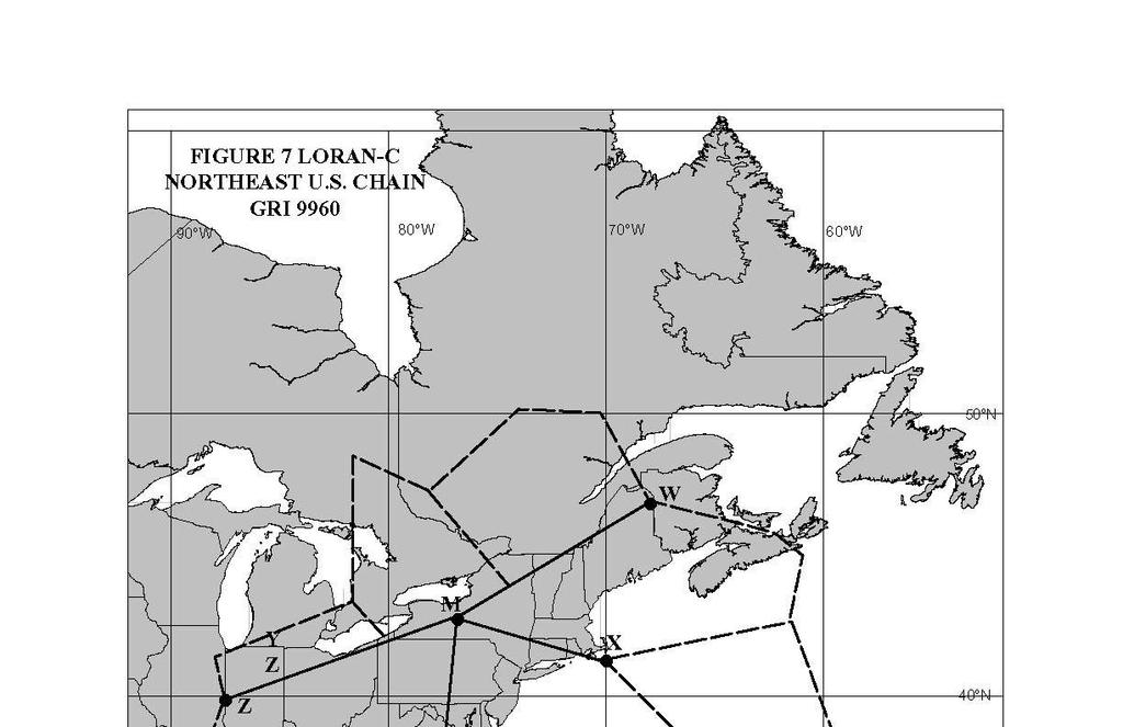
1 PART 6 LORAN-C NAVIGATION SYSTEM TABLES FIGURES 1 NEWFOUNDLAND EAST COAST LORAN-C CHAIN GRI CANADIAN EAST COAST LORAN-C CHAIN GRI GREAT LAKES LORAN-C CHAIN - GRI NORTHEAST U.S. LORAN-C CHAIN GRI LORAN-C CHAIN COVERAGE OF NORTH AMERICA 2 LORAN-C COVERAGE DIAGRAM - EAST COAST 3 LORAN-C COVERAGE DIAGRAM - GREAT LAKES 4 NEWFOUNDLAND EAST COAST CHAIN COVERAGE DIAGRAM 5 CANADIAN EAST COAST CHAIN COVERAGE DIAGRAM 6 GREAT LAKES CHAIN COVERAGE DIAGRAM 7 NORTHEAST U.S. CHAIN COVERAGE DIAGRAM 8 INDEX AND CHARTLETS SHOWING ADDITIONAL SECONDARY FACTOR CORRECTIONS- EAST COAST 9 INDEX AND CHARTLETS SHOWING ADDITIONAL SECONDARY FACTOR CORRECTIONS- GREAT LAKES A. Loran-C Chain Coverage Figure 1 shows the North American coverage of Loran-C while Figures 2 and 3 show the Loran-C coverage existing on the East Coast of Canada and on the Great Lakes (respectively). They show the recommended Loran-C chains, and the station pairs within a particular chain, to be used within the various coverage areas. The following note pertains to Figure 2 and 3. Note: The dividing lines between the Loran-C rates do not necessarily mean there are no other suitable Loran-C stations/chains which could be used to safely navigate in an area. Example Figure 2, while it is recommended to use 5930XY (Caribou - Nantucket - Cape Race on rate 5930) off Halifax, coverage also exists there for 9960WZ and 5930XZ. It is simply estimated that 5930XY provides better coverage in this area. Example Figure 3, while it is recommended to use 9960YZ (i.e., Seneca Carolina Beach Dana on rate 9960) in Lake Erie, coverage also exists there for 9960WZ and 8970XY. It is simply estimated that 9960YZ provides better coverage in Lake Erie. The individual coverage patterns shown in Figures 4, 5 & 7 are provided by the Newfoundland East Coast, Canadian East Coast and Northeast U.S. Loran-C chains respectively. Those patterns provided by the Great Lakes coverage are shown in Figure 6. B. Chain Details Technical details of chains that provide coverage in waters off Eastern Canada are shown in Tables 1&2 and coverage in the Great Lakes is shown in Table 3. Table 4 shows the Northeast U.S. chains which cover the Great Lakes and East Coast. C. Loran-C Coordinate Converters Listing of vectors from the Loran-C coordinate converter position to the true position. 6-1
2 D. Loran-C Receiver Latitude/Longitude Corrections Today s Loran-C receivers are equipped with microprocessors which are designed to internally compute the latitude and longitude coordinates of the receiver, based on the Time Difference (TD) readings, and directly display these values. This reduces the need to possess to Loran-C charts, though it is still recommended that they be procured. The latitude/longitude computation may be based upon a pure seawater path. This leads to errors if the Loran-C signals from the various stations involve appreciable overland paths since the speed of the signal will decrease by varying amounts, depending on the nature of the earth s surface over which it is passing. Loran-C operates by measuring the difference in arrival times of the signals from the different stations in the Loran-C chain, and thus any unforeseen variation in the speed of a signal will result in an error in the latitude/longitude reading. Note that when the receiver is being used in the time difference mode (time difference readings being used to manually plot lines of position on a Loran-C chart), these errors are minimal and the system should be accurate to within 1 /4 nautical mile. This is because the Loran-C lattice on a nautical chart has already been adjusted to allow for the signal variation as it travels over land. It is recommended that mariners using the latitude/longitude feature of their receiver check the manufacturer s operating manual to determine if corrections are necessary and how they may be applied to compensate for overland paths in order to obtain a greater fix accuracy. The correction can be applied in either of two forms: (i) insertion of a correction when the vessel is at a known location, or (ii) the insertion of a correction factor that is determined from a table or chartlet. The latter is called an Additional Secondary Phase Factor (ASF) correction, and the chartlets in Figures 8 & 9 can be used to ascertain the numeric value to apply. These corrections will normally be valid only within 50 to 100 miles of the location at which the correction was inserted because of the changing effects of land mass on the Loran signals in the different areas. E. Waypoint Navigation Cautionary Note Mariners are cautioned that an error can exist between the waypoint navigation information provided by their Locan-C receiver and the desired straight-line track plotted on a chart. A straight line course plotted between two waypoints on a mercator chart is a rhumb line, defined as a line on the earth s surface cutting the meridians of longitude at the same angle. The course and distance displayed by a microprocessor-based Loran-C receiver, used in the waypoint mode, are normally computed for a great circle track, not a rhumb line. In the northern hemisphere, a great circle track between two normal waypoints lies to the north of a rhumb line joining those same waypoints. This offset distance, or error, is a maximum when sailing East-West at a latitude of approximately 45 degrees, decreasing to zero at the equator and at the North and South Poles. It also decreases to zero as your track becomes North-South, regardless of the latitude. As an example of the offset error possible, a journey from St. John s, Newfoundland, to the Lands End area, England, a distance of roughly 1850 nm, would have a maximum offset of approximately 140 nm when comparing a rhumb line and a great circle track between the two places. The rhumb line versus great circle path offset becomes a danger only if the mariner has not laid off a great circle course on a Gnomonic chart, ensuring the vessel will pass clear of all navigation dangers. F. Loran-C Skywave Interference It has been found that the skywave effects are minimal if the receiver is properly installed and operated. Special attention should be given to receiver grounding, placement of the antenna and the elimination of shipboard interference. G. Loran-C System Status Information Up-to-date Loran-C status information is available by telephoning: Loran-C Chain/Rate Newfoundland East Coast Chain 7270 Canadian East Coast/5930 Northeast U.S./9960 Great Lakes/8970 Phone Number/Location (709) Control/Monitor, St. Anthony, Nfld. (709) Control/Monitor, St. Anthony, Nfld. (703) USCG NAVCEN, Alexandria, Va (703) USCG NAVCEN, Alexandria, Va 6-2
3 H. Loran-C NOTSHIPs Loran-C Notices to Shipping (NOTSHIPs) concerning the status of Loran-C signals in eastern Canadian waters and in the Great Lakes, the immediate proximity are broadcast from the following Marine Communications and Traffic Services Centres (MCTS) and their respective remotely-controlled facilities: St. Anthony Labrador Saint John Quebec Sarnia St. John s Halifax Rivière-au-Renard Montreal Thunder Bay Port-aux-Basques Sydney Les Escoumins Prescott Note that these broadcasts may only be made from those MCTS Centres located in the general area where the Loran-C signal normally exists. TABLE 1 NEWFOUNDLAND EAST COAST LORAN-C CHAIN GRI 7270 STATION LOCATION (NAD83) FUNCTION EMISSION DELAY THEORETICAL BASELINE TRAVEL TIME (1) RADIATED PEAK POWER COMFORT COVE, Newfoundland N W MASTER 185 kw CAPE RACE, Newfoundland FOX HARBOUR, Labrador N W N W WHISKEY SECONDARY XRAY SECONDARY µs µs 500 kw µs µs 800 kw (1) Theoretical baseline travel time is based on all-seawater transmission path between master and secondary. (2) Vessels passing in the immediate vicinity of the Fox Harbour station may experience interference on their communication receivers. Reception of weak communication signals may not be possible on vessels that are within 10 miles of Fox Harbour. STATION TABLE 2 CANADIAN EAST COAST LORAN-C CHAIN GRI 5930 LOCATION (NAD 83) THEORETICAL FUNCTION EMISSION DELAY THEORETICAL BASELINE TRAVEL TIME (1) RADIATED PEAK POWER CARIBOU, Maine (2) NANTUCKET, Massachusetts (2) CAPE RACE, Newfoundland FOX HARBOUR, Labrador (3) N W N W N W N W MASTER 800 kw X SECONDARY µs µs 375 kw Y SECONDARY µs µs 500 kw Z SECONDARY µs µs 800 kw (1) Theoretical baseline travel time is based on all-seawater transmission path between master and secondary. (2) This station operated by United States of America. (3) Vessels passing in the immediate vicinity of the Fox Harbour station may experience interference on their communication receivers. Reception of weak communication signals may not be possible on vessels that are within 10 miles of Fox Harbour. 6-3
4 TABLE 3 GREAT LAKES LORAN-C CHAIN GRI 8970 STATION LOCATION (1) FUNCTION EMISSION DELAY THEORETICAL BASELINE TRAVEL TIME (2) RADIATED PEAK POWER DANA, Indiana (3) MALONE, Florida (3) SENECA, New York (3) BAUDETTE, Minnesota (3) BOISE CITY, Oklahoma (3) N W N W N W N W N W MASTER 400 kw W SECONDARY µs µs 800 kw X SECONDARY µs µs 800 kw Y SECONDARY µs µs 800 kw Z SECONDARY µs µs 800 kw (1) Based on WGS 84 (coordinate system for charting) (2) Theoretical baseline travel time is based on all-seawater transmission path between master and secondary (3) This station is operated by the United States of America TABLE 4 NORTHEAST U.S. LORAN-C CHAIN GRI 9960 STATION LOCATION (NAD 83) FUNCTION EMISSION DELAY THEORETICAL BASELINE (2) TRAVEL TIME RADIATED PEAK POWER SENECA, New York (3) CARIBOU, Maine (3) NANTUCKET, Massachusetts (3) CAROLINA BEACH North Carolina (3) DANA, Indiana (3) N W N W N W N W N W MASTER 800 kw W SECONDARY µ s µ s 800 Kw X SECONDARY µ s µ s 375 kw Y SECONDARY µ s µ s 800 kw Z SECONDARY µ s µ s 400 kw (1) Based on WGS 84 (Coordinated system for charting) (2) Theoretical baseline travel time is based on all-seawater transmission path between master and secondary (3) This station operated by United States of America. 6-4
5 Loran-C Coordinate Converters Many of the Loran-C Coordinate Converters on the market do not compensate for the overland propagation errors caused by radio waves travelling more slowly over land than they do over seawater. These converters assume that the radio waves are travelling over an all seawater path from the transmitters to the ship. Because the amount of the time delay in each pattern varies with location, as does the width for 1 microsecond in each pattern, and the angle of cut between patterns, and which two patterns are being used for the position determination, there can be no over-all simple error statement. It is important to note that a Loran-C coordinate converter that does not incorporate the overland propagation corrections (Additional Secondary Factor, or ASF) within its computations will produce a systematic geographic position error. This error is often in the dangerous direction; namely, it will compute a position that is farther offshore. If you are transiting along a coast, thinking that you are safely outside the dangerous shoals, you may find yourself closer to shore than you think you are. The Canadian Hydrographic Service (CHS) has determined the overland propagation (ASF) errors through actual observations. The overland propagation corrections were incorporated into the lattices that were/are on CHS nautical charts. These maps have been published showing the corrections to observed Time Differences (TD s) necessary to make them theoretical TD s that can be used with algorithms using just the seawater velocity to compute the geographic position. Manufacturers have their own methods to compute geographic positions, which may incorporate some approximations. The receivers may or may not tell the mariner which TD s it is using to compute the position hopefully the pair with the best repeatable geometry. Some receivers use more than two TD s to compute positions. Some manufacturers have incorporated the overland propagation corrections into their algorithms and those receivers should perform more accurately than those that do not. The industry self-imposed standard set by the Radio Technical Commission on Marine Services - Special Committee 75 on Minimum Performance Standards for Loran-C Coordinate Converters (1980) is a ¼ mile positioning accuracy. The following tables give the vectors from the Loran-C coordinate converter position to the true position. These will give some guide as to the possible errors. It is suggested, however, that mariners NOT correct their positions by the stated amounts, but to use the listed information as an advisory. Your coordinate converter may behave differently Canadian East Coast Chain Information in Bold is for the TD pair that gives the best repeatability. Vicinity of: Latitude Longitude 5930XY 5930XZ 5930YZ Gulf of Maine Georges Bank N W T Georges Bank N W T Bay of Fundy Machias Seal I N W T Saint John N W T Cape d'or N W T Digby N W T Brier Island N W T Western Nova Scotia Yarmouth N W T Seal Island N W T South Shore, Nova Scotia Shelburne N W T Mahone Bay N W T Mahone Bay N W T Sambro Island N W T 5930 Canadian East Coast Chain 6-5
6 Information in Bold is for the TD pair that gives the best repeatability. Vicinity of: Latitude Longitude 5930XY 5930XZ 5930YZ Eastern Shore, Nova Scotia Sheet Harbour N W T Country Harbour N W T Canso N W T Pt Michaud N W T Sable Island West end N W T T T East end N W T T T Cape Breton Island Scaterie Island N W T T T Sydney N W T T T Cape Egmont N W 0.0 nm 0.0 nm T Gulf of St. Lawrence, southern part Cheticamp N W T T T Cape George N W T T T S of Magdalen Is N W T T 0.0 nm North Cape, PEI N W T T 0.0 nm Cape Egmont N W T T T Gulf of St. Lawrence, western part Miscou Island N W T T T Baie des Chaleurs N W T T Gaspe N W T T Grande-Vallee N W T T Marsoui N W 0.0 nm River St. Lawrence Pte des Monts N W T Baie Comeau N W T Pte Mitis N W T T Les Escoumins N W T T T Malbaie N W T T T Ile aux Coudres N W T T T Ile aux Ruaux N W Gulf of St. Lawrence, northern part Sept Iles N W T Sheldrake N W T Mingan N W T Natashquan N W T Pointe Heath N W T T T R aux Oiseaux N W T T T Cap Whittle N W T B de St. Augustin N W T Greely Island N W T 6-6
7 5930 Canadian East Coast Chain Information in Bold is for the TD pair that gives the best repeatability. Vicinity of: Latitude Longitude 5930XY 5930XZ 5930YZ Gulf of St. Lawrence, eastern part Pte Riche N W T Bay of Islands N W T T T C St George N W T T T C Anguille N W T T T South Coast of Newfoundland Cape Ray N W 0.0 nm T T Ramea N W 0.0 nm T T Pass Island N W T T T St Pierre N W T T T off Placentia Bay N W T T T Argentia N W T T 0.0 nm C St Mary's N W T T T Cape Race N W T T T East Coast of Newfoundland Virgin Rocks N W T Ferryland Head N W T St John's N W T Baccalieu Island N W T Bonavista N W T Cape Freels N W T Funk Island N W T North Coast of Newfoundland Fogo Island N W T Gull Island N W T Grey Islands N W T Quirpon N W T St Lewis Sound N W T Strait of Belle Isle N W T Offshore, near 200 nm Limit N W T N W T N W T T T N W T T Parallel LOP's N W T T T N W T N W T N W T East Newfoundland Chain Information in Bold is for the TD pair that gives the best repeatability. Vicinity of: Latitude Longitude 7270WX East Coast of Newfoundland Virgin Rocks N W T Ferryland Head N W T 6-7
8 East Newfoundland Chain Information in Bold is for the TD pair that gives the best repeatability. Vicinity of: Latitude Longitude 7270WX St John's N W T Baccalieu Island N W T Bonavista N W T Cape Freels N W T Funk Island N W T North Coast of Newfoundland Fogo Island N W T Gull Island N W Baseline ext. Grey Islands N W Baseline ext. Quirpon N W Baseline ext. St Lewis Sound N W Baseline ext. Strait of Belle Isle N W Baseline ext. Offshore, near 200 nm Limit N W Baseline ext N W T N W T N W T 9960 North East United States Chain Information in Bold is for the TD pair that gives the best repeatability. Vicinity of: Latitude Longitude 9960WX 9960WY Gulf of Maine Georges Bank N W Baseline ext T Georges Bank N W T T Bay of Fundy Machias Seal I N W T T Saint John N W T Cape d'or N W Digby N W T Brier Island N W T T Western Nova Scotia Yarmouth N W T T Seal Island N W T T River St. Lawrence Baie Comeau N W T Pte Mitis N W T Les Escoumins N W T Malbaie N W T Île aux Coudres N W T Île aux Ruaux N W T 6-8
9 8970 Great Lakes Chain Information in Bold is for the TD pair that gives the best repeatability. Vicinity of: Latitude Longitude 9960WZ 9960YZ 8970XY Lake Ontario Kingston N W T Cobourg N W T T Hamilton N W T T Lake Erie Port Colborne N W T T Long Point N W T T Rondeau N W T T Amherstburg N W T T Lake St. Clair mid-lake N W T T Lake Huron Sarnia N W T Point Clark N W T Cape Hurd N W T Great Duck Island N W T Detour Passage N W T North Channel, Lake Huron Thessalon N W T Gore Bay N W T Georgian Bay Squaw Island N W T Cabot Head N W T Collingwood N W T Parry Sound N W T French River N W T Lake Superior Île Parisienne N W T Caribou Island N W T Brule Point N W T Superior Shoal N W T Marathon N W T Passage Island N W T Thunder Bay N W T 6-9

10 6-10
11 6-11

12 6-12

13 6-13

14 6-14


15 6-15

16 6-16

17 6-17
18 6-18
RADIO AIDS TO MARINE NAVIGATION (Atlantic, St. Lawrence, Great Lakes, Lake Winnipeg and Eastern Arctic) CANADIAN COAST GUARD
 CANADIAN COAST GUARD") RADIO AIDS TO MARINE NAVIGATION (Atlantic, St Lawrence, Great Lakes, Lake Winnipeg and Eastern Arctic) CANADIAN COAST GUARD Marine Communications and Traffic Services Annual Edition 2006 IMPORTANT This
RADIO AIDS TO MARINE NAVIGATION (Atlantic, St Lawrence, Great Lakes, Lake Winnipeg and Eastern Arctic) CANADIAN COAST GUARD Marine Communications and Traffic Services Annual Edition 2006 IMPORTANT This
1.1.2 Change to Maritime Mobile Service Identity (MMSI) Numbers
 Numbers") PART 1 FOREWORD 1.1 ADVANCE NOTICES In order that mariners may have advance knowledge of proposed changes to existing facilities to be provided, additions, deletions and changes to such facilities under
PART 1 FOREWORD 1.1 ADVANCE NOTICES In order that mariners may have advance knowledge of proposed changes to existing facilities to be provided, additions, deletions and changes to such facilities under
RADIO AIDS TO MARINE NAVIGATION (Pacific and Western Arctic) CANADIAN COAST GUARD. Marine Communications and Traffic Services. Annual Edition 2007
 CANADIAN COAST GUARD. Marine Communications and Traffic Services. Annual Edition 2007") RADIO AIDS TO MARINE NAVIGATION (Pacific and Western Arctic) CANADIAN COAST GUARD Marine Communications and Traffic Services Annual Edition 2007 IMPORTANT This publication is revised on a monthly basis
RADIO AIDS TO MARINE NAVIGATION (Pacific and Western Arctic) CANADIAN COAST GUARD Marine Communications and Traffic Services Annual Edition 2007 IMPORTANT This publication is revised on a monthly basis
Essentials of Navigation
 Essentials of Navigation Latitudes & Longitudes, GPS, and more For Race Officers and Mark Boat Operators by Ed Bottrell eztrap Developer Glen Haven, Nova Scotia CANADA v13 email: info@bottrell.ca Website:
Radio Aids to Marine Navigation 2016 (Atlantic, St. Lawrence, Great Lakes, Lake Winnipeg and Arctic)
") Radio Aids to Marine Navigation 2016 (Atlantic, St. Lawrence, Great Lakes, Lake Winnipeg and Arctic) EKME #3564491 Radio Aids to Marine Navigation 2016 (Atlantic, St. Lawrence, Great Lakes, Lake Winnipeg
Radio Aids to Marine Navigation 2016 (Atlantic, St. Lawrence, Great Lakes, Lake Winnipeg and Arctic) EKME #3564491 Radio Aids to Marine Navigation 2016 (Atlantic, St. Lawrence, Great Lakes, Lake Winnipeg
SECTION III NM 15/12 MARINE INFORMATION
 SECTION III NM 15/12 MARINE INFORMATION CHANGES TO BROADCAST OF WEATHER FORECASTS FOR THE OFFSHORE SOUTHWEST NORTH ATLANTIC, CARIBBEAN, AND GULF OF MEXICO Effective Tuesday April 03, 2012 at 2:00 pm Eastern
GPS & DGPS Made Easy
 NOTE GPS & DGPS Made Easy This booklet is intended to provide mariners with a basic understanding of the Global Positioning System (GPS) and the Differential Global Positioning System (DGPS), and to assist
2. CHARTS. 2.1 Chart projections Mercator projections. Maps which are used for marine or aeronautical navigation are called charts.
 Maps which are used for marine or aeronautical navigation are called charts. In Canadian waters, mariners are required to carry the latest editions of the paper charts, at the largest scale available (see
ST. VINCENT AND THE GRENADINES
 ST. VINCENT AND THE GRENADINES MARITIME ADMINISTRATION CIRCULAR N GEN 012 INTERNATIONAL ICE PATROL SERVICES - 2011-02-23 IMO Circular SN.1/Circ.299 TO: APPLICABLE TO: EFFECTIVE AS FROM: SHIPOWNERS, SHIPS
NEWFOUNDLAND AND LABRADOR COAST. List of Lights, Buoys and Fog Signals. CANADIAN COAST GUARD Maritime Services
 NEWFOUNDLAND AND LABRADOR COAST List of Lights, Buoys and Fog Signals CANADIAN COAST GUARD Maritime Services LIGHTS, BUOYS AND FOG SIGNALS NEWFOUNDLAND AND LABRADOR COAST Canadian Coast Guard MARITIME
Radio Aids to Marine Navigation 2017 (Atlantic, St. Lawrence, Great Lakes, Lake Winnipeg, Arctic and Pacific)
") Radio Aids to Marine Navigation 2017 (Atlantic, St. Lawrence, Great Lakes, Lake Winnipeg, Arctic and Pacific) EKME #3608779 Radio Aids to Marine Navigation 2017 (Atlantic, St. Lawrence, Great Lakes, Lake
Radio Aids to Marine Navigation 2017 (Atlantic, St. Lawrence, Great Lakes, Lake Winnipeg, Arctic and Pacific) EKME #3608779 Radio Aids to Marine Navigation 2017 (Atlantic, St. Lawrence, Great Lakes, Lake
CHAPTER 24 LORAN NAVIGATION
 CHAPTER 24 LORAN NAVIGATION INTRODUCTION TO LORAN 2400. History and Role of Loran The theory behind the operation of hyperbolic navigation systems was known in the late 1930s, but it took the urgency of
CHAPTER 12 HYPERBOLIC SYSTEMS
 CHAPTER 12 HYPERBOLIC SYSTEMS INTRODUCTION TO LORAN C 1200. History The theory behind the operation of hyperbolic radionavigation systems was known in the late 1930 s, but it took the urgency of World
SECTION III NM 24/15 MARINE INFORMATION
 SECTION III NM 24/15 MARINE INFORMATION NATIONAL GEOSPATIAL-INTELLIGENCE AGENCY'S (NGA) GUIDANCE ON THE PROPER DISPLAY SCALE OF DIGITAL NAUTICAL CHART (DNC) DATA The DNC portfolio was originally created
Radio Aids to Marine Navigation 2018 (Atlantic, St. Lawrence, Great Lakes, Lake Winnipeg, Arctic and Pacific)
") Radio Aids to Marine Navigation 2018 (Atlantic, St. Lawrence, Great Lakes, Lake Winnipeg, Arctic and Pacific) EKME #3870409 Radio Aids to Marine Navigation 2018 (Atlantic, St. Lawrence, Great Lakes, Lake
Radio Aids to Marine Navigation 2018 (Atlantic, St. Lawrence, Great Lakes, Lake Winnipeg, Arctic and Pacific) EKME #3870409 Radio Aids to Marine Navigation 2018 (Atlantic, St. Lawrence, Great Lakes, Lake
WWNWS9/3/2/XVII_XVIII Meeting 9 21 July 2017 Agenda Item 3.2. MSI Self Assessment NAVAREA XVII_XVIII. Submitted by Canada (Canadian Coast Guard)
") WWNWS WWNWS9/3/2/XVII_XVIII Meeting 9 21 July 2017 Agenda Item 3.2 MSI Self Assessment NAVAREA XVII_XVIII Submitted by Canada (Canadian Coast Guard) SUMMARY Executive Summary: Summary of activities within
WWNWS WWNWS9/3/2/XVII_XVIII Meeting 9 21 July 2017 Agenda Item 3.2 MSI Self Assessment NAVAREA XVII_XVIII Submitted by Canada (Canadian Coast Guard) SUMMARY Executive Summary: Summary of activities within
PART 1 FOREWORD 1-1 ADVANCE NOTICES
 PART 1 FOREWORD ADVANCE NOTICES In order that mariners may have advance knowledge of proposed changes to existing facilities to be provided, additions, deletions and changes to such facilities under the
SECTION III NM 17/15 MARINE INFORMATION
 SECTION III NM 17/15 MARINE INFORMATION NOAA CHART NEW EDITIONS AND THEIR AVAILABILITY NOAA produces nautical chart products to support Federal chart carriage requirements. These nautical charts are available
SUMMARY: The Coast Guard is declaring Sea Area A1 in certain. areas off the coast of the United States based upon the
 DEPARTMENT OF HOMELAND SECURITY Coast Guard [Docket No. USCG-2015-0002] Declaration of Sea Area A1 ACTION: Notice. This document is scheduled to be published in the Federal Register on 01/20/2015 and available
Improvement of GPS Ambiguity Resolution Using Height Constraint for Bathymetric Surveys
 Improvement of GPS Ambiguity Resolution Using Height Constraint for Bathymetric Surveys Mami Ueno (Centre for Research in Geomatics, Laval University, Ste-Foy, QC G1K 7P4, Canada; (418) 656-2131 #7149;
NEWFOUNDLAND AND LABRADOR COAST. List of Lights, Buoys and Fog Signals CANADIAN COAST GUARD
 NEWFOUNDLAND AND LABRADOR COAST List of Lights, Buoys and Fog Signals CANADIAN COAST GUARD LIGHTS, BUOYS AND FOG SIGNALS NEWFOUNDLAND AND LABRADOR COAST Canadian Coast Guard Cette publication est aussi
Sea Duck Joint Venture Annual Project Summary for Endorsed Projects FY 2010 (October 1, 2009 to Sept 30, 2010)
") Sea Duck Joint Venture Annual Project Summary for Endorsed Projects FY 2010 (October 1, 2009 to Sept 30, 2010) Project Title: SDJV # 117 Population Delineation, Migratory Connectivity and Habitat Use of
Sea Duck Joint Venture Annual Project Summary for Endorsed Projects FY 2010 (October 1, 2009 to Sept 30, 2010) Project Title: SDJV # 117 Population Delineation, Migratory Connectivity and Habitat Use of
The Canadian Population: Age and Sex
 Protected Document The Canadian Population: Age and Sex 2011 Census of Canada Presentation of the main results from the age and sex release by France-Pascale Ménard and Laurent Martel (Demography Division)
NOTICES TO MARINERS PUBLICATION EASTERN EDITION. CANADIAN COAST GUARD
 NOTICES TO MARINERS PUBLICATION EASTERN EDITION MONTHLY EDITION N O 1 January 30th, 2015 Published monthly by the CANADIAN COAST GUARD www.notmar.gc.ca/subscribe CONTENTS Section 1 Safety and General Information...
Standard Operating Procedures for: VHF Marine Radio
 Serenity Houseboat I. Overview Standard Operating Procedures for: VHF Marine Radio VHF, or Very High Frequency, marine radio is the standard method of communication between vessels. Marine radio equipment
DSC WATCH - Coast stations participating in MF, HF and VHF watch-keeping using digital selective calling techniques
 CAN - Canada NOTES DSC WATCH - Coast stations participating in MF, HF and VHF watch-keeping using digital selective calling techniques DC1 Open only during the season of navigation, as advertised in the
SECTION III NM 39/13 MARINE INFORMATION NGA CHART NEW EDITIONS AND THEIR AVAILABILITY
 SECTION III NM 39/13 MARINE INFORMATION NGA CHART NEW EDITIONS AND THEIR AVAILABILITY NGA standard nautical hardcopy chart products are made available and distributed by three different authorized methods:
SECTION III NM 41/14 MARINE INFORMATION
 MARINE INFORMATION NOAA CHART NEW EDITIONS AND THEIR AVAILABILITY NOAA recognizes two paper nautical chart products: Print-on-Demand (POD) and traditional paper charts. - Print-on-Demand (POD) charts are
Providing a Resilient Timing and UTC Service Using eloran in the United States. Charles Schue - ION PTTI Monterey, CA
 Providing a Resilient Timing and UTC Service Using eloran in the United States Charles Schue - ION PTTI Monterey, CA January 27, 2016 Motivation For a Resilient Timing and UTC Service GPS/GNSS Vulnerabilities
CAN LORAN MEET GPS BACKUP REQUIREMENTS?
 To be presented at the 11 th Saint Petersburg International Conference on Integrated Navigation Systems, 24 26 May 24 CAN LORAN MEET GPS BACKUP REQUIREMENTS? Gregory Johnson, MSEE, Ruslan Shalaev, BSCS
NOTICES TO MARINERS PUBLICATION EASTERN EDITION
 NOTICES TO MARINERS PUBLICATION EASTERN EDITION MONTHLY EDITION N O 8 AUGUST 28 th, 2015 Published monthly by the CANADIAN COAST GUARD www.notmar.gc.ca/subscribe CONTENTS Section 1 Safety and General Information...
SECTION III NM 34/14 MARINE INFORMATION
 MARINE INFORMATION AREAS TO BE AVOIDED (OCEANOGRAPHIC MOORINGS) IN THE EQUATORIAL PACIFIC OCEAN The National Oceanic and Atmospheric Administration (NOAA) maintains various buoys in the Equatorial Pacific
7 Picturing energy: image cards Illustrer l énergie: fiches d images. Photo: istockphoto.com
 7 Picturing energy: image cards Illustrer l énergie: fiches d images Photo: istockphoto.com Sarnia Solar Project Projet énergie solaire de Sarnia 42.94, -82.34 Sarnia, Ontario Sarnia, Ontario 7 Picturing
THE ELECTRONIC CHART DISPLAY AND INFORMATION SYSTEM (ECDIS) IN CHINA
 IN CHINA") International Hydrographic 'Review, Monaco, LXIX(2), September 1992 THE ELECTRONIC CHART DISPLAY AND INFORMATION SYSTEM (ECDIS) IN CHINA by The Research Group on ECDIS 1 Abstract This paper presents a
International Hydrographic 'Review, Monaco, LXIX(2), September 1992 THE ELECTRONIC CHART DISPLAY AND INFORMATION SYSTEM (ECDIS) IN CHINA by The Research Group on ECDIS 1 Abstract This paper presents a
IMO/IHO World-wide Navigational Warning Service (WWNWS)
") IMO/IHO World-wide Navigational Warning Service (WWNWS) 1 WWNWS 1972 PROPOSAL TO SET UP AN Ad Hoc IHO/IMO COMMITTEE TO DEVELOP AN INTER- NATIONALLY CO-ORDINATED SYSTEM FOR PROMULGATING LONG RANGE NAVIGATIONAL
IMO/IHO World-wide Navigational Warning Service (WWNWS) 1 WWNWS 1972 PROPOSAL TO SET UP AN Ad Hoc IHO/IMO COMMITTEE TO DEVELOP AN INTER- NATIONALLY CO-ORDINATED SYSTEM FOR PROMULGATING LONG RANGE NAVIGATIONAL
SECTION III NM 40/17 MARINE INFORMATION
 SECTION III NM 40/17 MARINE INFORMATION NEW EDITION OF COAST PILOT U.S. Coast Pilot 4, Atlantic Coast: Cape Henry, VA to Key West, FL, forty-ninth edition, 2017, has been issued and is ready for free download
SECTION III NM 32/13 MARINE INFORMATION NOAA CHART NEW EDITIONS AND THEIR AVAILABILITY
 MARINE INFORMATION NOAA CHART NEW EDITIONS AND THEIR AVAILABILITY NOAA recognizes two paper nautical chart products: Print-on-Demand (POD) and traditional paper charts. - Print-on-Demand (POD) charts are
Nova Scotia Public Safety and Field Communications
 Nova Scotia Public Safety and Field Communications Agency roundup March 7-8 2017 Wildfire Communications Workshop Nova Scotia TMR2 Video https://youtu.be/iingcdobm9e Maritime Public Safety Radio Network
SECTION III NM 4/16 MARINE INFORMATION
 MARINE INFORMATION NOAA CHART NEW EDITIONS AND THEIR AVAILABILITY NOAA produces nautical chart products to support Federal chart carriage requirements. These nautical charts are available as Print on Demand
NOTICE TO USERS MAILING LIST SUBSCRIPTION RENEWAL
 NOTICE TO USERS MAILING LIST SUBSCRIPTION RENEWAL Dear Client: We appreciate your continued interest in receiving the Monthly Edition of Notices to Mariners. As technology evolves, the Canadian Coast Guard
Marine Weather Program
 Marine Weather Program Shipping Federation of Canada Marine Workshop 2018 Montreal daniel.huang@canada.ca Meteorological Service of Canada Jan 31, 2018 ECCC is actively adapting its marine weather observing
SECTION III NM 50/12 MARINE INFORMATION NOAA CHART NEW EDITIONS AND THEIR AVAILABILITY
 SECTION III NM 50/12 MARINE INFORMATION NOAA CHART NEW EDITIONS AND THEIR AVAILABILITY NOAA recognizes two paper nautical chart products: - the Print-on-Demand (POD) chart distributed by OceanGrafix (www.oceangrafix.com),
RECOMMENDATION ITU-R P Prediction of sky-wave field strength at frequencies between about 150 and khz
 Rec. ITU-R P.1147-2 1 RECOMMENDATION ITU-R P.1147-2 Prediction of sky-wave field strength at frequencies between about 150 and 1 700 khz (Question ITU-R 225/3) (1995-1999-2003) The ITU Radiocommunication
LEw s, Banding European Cormorants [11. banded in JNorth America only at two breeding colonies on the
 Vol. ¾III 10a7 LEw s, Banding European Cormorants [11 RESULTS FRQM BANDING EUROPEAN CORMORANTS By HAnatso F. LEwts, t EU} OrEA COa OaA TS (Phalacrocorax carbo carbo) have been banded in JNorth America
Airport ASF Mapping Methodology Update
 Airport ASF Mapping Methodology Update Peter F. Swaszek, University of Rhode Island Gregory Johnson, Mark Wiggins, Michael Kuhn, Alion Science & Technology Richard Hartnett, US Coast Guard Academy Kevin
UNIT 26 ELECTRONIC AIDS TO NAVIGATION
 UNIT 26 ELECTRONIC AIDS TO NAVIGATION Basic terms aid to navigation >Loran-C >Omega >Transit satellite >GPS >hyperbolic systems > satellite navigation system >fix accuracy small-screen >satnav receiver
NOTICES TO MARINERS PUBLICATION WESTERN EDITION
 Fisheries and Oceans Canada Pêches et Océans Canada VOL. 32, MONTHLY EDITION N O 09 SEPTEMBER 28, 2007 Publication Number 40063779 NOTICES TO MARINERS PUBLICATION WESTERN EDITION Published monthly by the
3. GPS receiver instruction cards GPS receivers
 Subject: GPS (& how its applications with Agriculture) Date: June 10, 2010 Lesson Title: Where exactly are we? Grade Level: Upper Elementary/Middle School Time period: 60-90 minutes Lesson Objectives:
INLAND WATERS. List of Lights, Buoys and Fog Signals CANADIAN COAST GUARD
 INLAND WATERS List of Lights, Buoys and Fog Signals CANADIAN COAST GUARD LIGHTS, BUOYS AND FOG SIGNALS INLAND WATERS INCLUDING (WEST OF MONTRÉAL AND EAST OF BRITISH COLUMBIA) Canadian Coast Guard Cette
by Williston Shor nd St., N.W. Washington, D.C
 BANDING RECOVERIES OF ARCTIC MIGRANT PEREGRINES OF THE ATLANTIC COAST AND GREENLAND POPULATIONS by Williston Shor 6614 32nd St., N.W. Washington, D.C. 20015 A strong/'all migration of pere ine falcons
PACIFIC COAST. List of Lights, Buoys and Fog Signals CANADIAN COAST GUARD
 PACIFIC COAST List of Lights, Buoys and Fog Signals CANADIAN COAST GUARD LIGHTS, BUOYS AND FOG SIGNALS PACIFIC COAST INCLUDING THE COASTAL WATERS, RIVERS AND LAKES OF BRITISH COLUMBIA Canadian Coast Guard
Mapping The Study Area
 While on the beach you will need to take some measurements to show where the study area is relative to the rest of the world and to show what is inside the study area. Once the measurements have been taken,
Implementing a Wide Area High Accuracy UTC Service via eloran
 Implementing a Wide Area High Accuracy UTC Service via eloran ION PTTI, Boston, MA December 3, 2014 Dr. Gerard Offermans Overview Basis for consideration of eloran as a source of precise time, frequency,
BookletChart. Intracoastal Waterway Grassy Key to Bahia Honda Key NOAA Chart A reduced-scale NOAA nautical chart for small boaters
 BookletChart Intracoastal Waterway Grassy Key to Bahia Honda Key NOAA Chart 11453 A reduced-scale NOAA nautical chart for small boaters When possible, use the full-size NOAA chart for navigation. Published
CPRNW. WWNWS9/3/3/3.2 Meeting 9 20 July 2017 Agenda Item Joint MET/NAVAREA XVII and XVIII Client Survey
 CPRNW WWNWS WWNWS9/3/3/3.2 Meeting 9 20 July 2017 Agenda Item 3.3.3.2 Joint MET/NAVAREA XVII and XVIII Client Survey Submitted by Canada, NAVAREA XVII_XVIII SUMMARY Executive Summary: This document describes
Modernized LORAN-C Timing Test Bed Status and Results
 Modernized LORAN-C Timing Test Bed Status and Results Tom Celano and Casey Biggs Timing Solutions Corporation 4775 Walnut St Boulder, CO tpcelano@timing.com Benjamin Peterson Peterson Integrated Positioning
Written Comment: Sydney Basin and Orpheus Graben Areas
 December 23, 2015 Written Comment: Sydney Basin and Orpheus Graben Areas Based on the draft Strategic Environmental Assessment 202 Brownlow Ave. Suite A305, Cambridge 1 Dartmouth, NS B3B 1T5 (902) 425-4774
What you should know about Loran-C receivers
 What you should know about Loran-C receivers Another title in the series Marine electronics by Daniel A. Panshin Extension Oceanographer Oregon State University Are you ready for Loran-C? What kind of
NOAA s National Ocean Service / Office of Coast Survey
 Coast Survey OCS 1807 2007 Maintains over 1000 nautical charts & 9 Coast Pilots Surveys over 3.4M SNM of oceans and lakes Conducts research and development in hydrography Thomas Jefferson Founder of The
Assessment of HF Radar for Significant Wave Height Determination. Desmond Power VP, Remote Sensing, C-CORE
 Assessment of HF Radar for Significant Wave Height Determination Desmond Power VP, Remote Sensing, C-CORE Study Rationale Agenda Technology Overview Technology Assessment for CNLOPB Proposed Go Forward
CanImage. (Landsat 7 Orthoimages at the 1: Scale) Standards and Specifications Edition 1.0
 Standards and Specifications Edition 1.0") CanImage (Landsat 7 Orthoimages at the 1:50 000 Scale) Standards and Specifications Edition 1.0 Centre for Topographic Information Customer Support Group 2144 King Street West, Suite 010 Sherbrooke, QC
CanImage (Landsat 7 Orthoimages at the 1:50 000 Scale) Standards and Specifications Edition 1.0 Centre for Topographic Information Customer Support Group 2144 King Street West, Suite 010 Sherbrooke, QC
Revisiting the freezing spray forecast algorithms used in Canada Une revisite des algorithmes de prévision d embruns verglaçants utilisés au Canada
 Revisiting the freezing spray forecast algorithms used in Canada Une revisite des algorithmes de prévision d embruns verglaçants utilisés au Canada par Serge Desjardins Mark Pilon Ted Mcildoon* National
NOTICES TO MARINERS PUBLICATION WESTERN EDITION
 VOL. 36, MONTHLY EDITION N O 02 February 25, 2011 Publication Number 40063779 NOTICES TO MARINERS PUBLICATION WESTERN EDITION Published monthly by the CANADIAN COAST GUARD http://www.notmar.gc.ca/subscribe/
How Automatic Identification System (AIS) Is Being Used to Improve Navigation Safety Lock Operations Management Application Michael Winkler
 Is Being Used to Improve Navigation Safety Lock Operations Management Application Michael Winkler") How Automatic Identification System (AIS) Is Being Used to Improve Navigation Safety Lock Operations Management Application Michael Winkler June 2016 LOMA system overview USCG AIS data capabilities: AIS
How Automatic Identification System (AIS) Is Being Used to Improve Navigation Safety Lock Operations Management Application Michael Winkler June 2016 LOMA system overview USCG AIS data capabilities: AIS
Enhancing Regional Connections: A Local/Regional Strategy
 Enhancing Regional Connections: A Local/Regional Strategy February 2, 2005 Local/Regional Reflection The Committee is very concerned that CBC budget cuts have led to a reduction of local reflection in
COAST GUARD PRECISION NAVIGATION PROGRAMS USING LORAN-C
 GLEN E. BAER and JOSEPH G. WALL COAST GUARD PRECISION NAVIGATION PROGRAMS USING LORAN-C This article is an overview of recent u.s. Coast Guard programs that use Loran-C for precision navigation in restricted
RESOLUTION MSC.278(85) (adopted on 1 December 2008) ADOPTION OF THE NEW MANDATORY SHIP REPORTING SYSTEM "OFF THE COAST OF PORTUGAL - COPREP"
 (adopted on 1 December 2008) ADOPTION OF THE NEW MANDATORY SHIP REPORTING SYSTEM OFF THE COAST OF PORTUGAL - COPREP") MSC 85/26/Add.1 RESOLUTION MSC.278(85) SYSTEM OFF THE COAST OF PORTUGAL COPREP THE MARITIME SAFETY COMMITTEE, RECALLING Article 28 of the Convention on the International Maritime Organization concerning
MSC 85/26/Add.1 RESOLUTION MSC.278(85) SYSTEM OFF THE COAST OF PORTUGAL COPREP THE MARITIME SAFETY COMMITTEE, RECALLING Article 28 of the Convention on the International Maritime Organization concerning
REVISED QUESTIONNAIRE ON SHORE-BASED FACILITIES FOR THE GLOBAL MARITIME DISTRESS AND SAFETY SYSTEM (GMDSS)
") E 4 ALBERT EMBANKMENT LONDON SE1 7SR Telephone: +44 (0)20 7735 7611 Fax: +44 (0)20 7587 3210 MSC.1/Circ.1382/Rev.2 24 June 2013 REVISED QUESTIONNAIRE ON SHORE-BASED FACILITIES FOR THE GLOBAL MARITIME DISTRESS
E 4 ALBERT EMBANKMENT LONDON SE1 7SR Telephone: +44 (0)20 7735 7611 Fax: +44 (0)20 7587 3210 MSC.1/Circ.1382/Rev.2 24 June 2013 REVISED QUESTIONNAIRE ON SHORE-BASED FACILITIES FOR THE GLOBAL MARITIME DISTRESS
Radio Station Licensing Procedure for Radiocommunication Service Providers System Licensing
 Issue 2 June 2011 Spectrum Management and Telecommunications Client Procedures Circular Radio Station Licensing Procedure for Radiocommunication Service Providers System Licensing Note: Editorial modifications
Math 11 Essentials -- Assignment - Chapter 7 -- Taking a Trip Name: Due: March 10, 2006
 Math 11 Essentials -- Assignment - Chapter 7 -- Taking a Trip Name: Due: March 10, 2006 The past few classes your have been researching a trip destination within a reasonable driving distance from your
SECTION III NM 35/10 MARINE INFORMATION NOAA CHART NEW EDITIONS AND THEIR AVAILABILITY
 SECTION III NM 35/10 MARINE INFORMATION NOAA CHART NEW EDITIONS AND THEIR AVAILABILITY NOAA recognizes two paper nautical chart products: - the Print-on-Demand (POD) chart distributed by OceanGrafix (www.oceangrafix.com),
NOTICES TO MARINERS PUBLICATION WESTERN EDITION
 NOTICES TO MARINERS PUBLICATION WESTERN EDITION MONTHLY EDITION N O 12 December 26, 2014 Published monthly by the CANADIAN COAST GUARD www.notmar.gc.ca/subscribe CONTENTS Section 1 Safety and General Information...
The Nautel Difference
 The Nautel Difference NAUTEL HAS A LONG HISTORY AND THE RESOURCES TO DELIVER THE BEST SOLUTION Founded in 1969 Over 11,000 systems shipped Systems installed in 177 countries Over 200 employees More than
NEW AND AMENDED TRAFFIC SEPARATION SCHEMES
 E 4 ALBERT EMBANKMENT LONDON SE1 7SR Telephone: +44 (0)20 7735 7611 Fax: +44 (0)20 7587 3210 NEW AND AMENDED TRAFFIC SEPARATION SCHEMES COLREG.2/Circ.67 20 May 2016 1 The Maritime Safety Committee, at
NOTICES TO MARINERS PUBLICATION EASTERN EDITION
 NOTICES TO MARINERS PUBLICATION EASTERN EDITION MONTHLY EDITION Nº06 June 29 th, 2018 Safety First, Service Always Published Monthly by the CANADIAN COAST GUARD www.notmar.gc.ca/subscribe CONTENTS Page
Standards for the Operation of Radio Stations in the Amateur Radio Service
 Issue 2 January 2014 Spectrum Management and Telecommunications Regulation by Reference Standards for the Operation of Radio Stations in the Amateur Radio Service Aussi disponible en français IPR-4 Preface
EASTERN EDITION OF NOTICES TO MARINERS
 Canada Canada VOL 23 MONTHLY EDITION NO 11 NOVEMBER 27,1998 EASTERN EDITION OF NOTICES TO MARINERS Published monthly by the CANADIAN COAST GUARD NOTICES 2100 to 2168 CONTENTS Page SEC. I Safety and General
National Marine Electronics Association International Marine Electronics Association. Technical Bulletin
 National Marine Electronics Association International Marine Electronics Association Technical Bulletin Amendment to NMEA 0183 Version 4.10 # AT 0183 20130815 NMEA 0183 Amendment An amendment is a technical
NEWFOUNDLAND AND LABRADOR COAST List of Lights, Buoys and Fog Signals. Focal Height in m. above water. Nominal. Range WHITE BAY
 NEWFOUNDLAND AND LABRADOR COAST List of s, Buoys and in meters 235 Quirpon N. end of Jacques- Cartier Island. 51 35 59.5 055 27 22 Fl W 6s 2 6 Square skeleton tower, red Flash 0.5 s; eclipse 4.5 s. 235.2
CONTENTS. INTRODUCTION 1 INTRODUCTION TO GPSPlus 3
 CONTENTS INTRODUCTION 1 INTRODUCTION TO GPSPlus 3 OPERATION OF GPSPlus 5 INTRODUCTION 6 SWITCHING ON 6 INITIAL DISPLAYS 6 USING THE LIGHTS KEY 7 NOTES ABOUT ENTERING DATA 7 USING THE POS KEY 8 USING WAYPOINTS
Defining Primary, Secondary, Additional Secondary Factors for RTCM Minimum Performance Specifications (MPS)
") Defining Primary, Secondary, Additional Secondary Factors for RTCM Minimum Performance Specifications (MPS) Sherman Lo, Stanford University, Michael Leathem, Cross Rate Technologies, Gerard Offermans,
Defining Primary, Secondary, Additional Secondary Factors for RTCM Minimum Performance Specifications (MPS) Sherman Lo, Stanford University, Michael Leathem, Cross Rate Technologies, Gerard Offermans,
RESOLUTION A.659(16) adopted on 19 October 1989 PROVISION OF RADIO SERVICES FOR THE GLOBAL MARITIME DISTRESS AND SAFETY SYSTEM
 adopted on 19 October 1989 PROVISION OF RADIO SERVICES FOR THE GLOBAL MARITIME DISTRESS AND SAFETY SYSTEM") INTERNATIONAL MARITIME ORGANIZATION RESOLUTION A.659(16) adopted on 19 October 1989 A 16/Res.659 30 November 1989 Original: ENGLISH ASSEMBLY - 16th session Agenda item 10 IMO RESOLUTION A.659(16) adopted
INTERNATIONAL MARITIME ORGANIZATION RESOLUTION A.659(16) adopted on 19 October 1989 A 16/Res.659 30 November 1989 Original: ENGLISH ASSEMBLY - 16th session Agenda item 10 IMO RESOLUTION A.659(16) adopted
IT'S YOUR TIME. BlueChart. g2 Vision HD
 IT'S YOUR TIME BlueChart g2 Vision HD Auto Guidance Garmin's patented Auto Guidance is now capable of providing routing guidance to virtually any accessible destination on the water. Auto Guidance provides
Wide Area Time distribution Via eloran. NASPI WG Meeting
 Wide Area Time distribution Via eloran NASPI WG Meeting March 22 2017 This work is supported through a Cooperative Research and Development Agreement (CRADA) with the Department of Homeland Security (DHS)
POLISH MARITIME DGPS REFERENCE STATIONS COVERAGE AFTER THE IMPLEMENTATION OF NEW FREQUENCY NET PRELIMINARY RESULTS.
 POLISH MARITIME DGPS REFERENCE STATIONS COVERAGE AFTER THE IMPLEMENTATION OF NEW FREQUENCY NET PRELIMINARY RESULTS. Cezary Specht Institute of Navigation and Hydrography of Naval University in Gdynia ABSTRACT
Ian D Souza (1), David Martin (2)
, David Martin (2)") NANO-SATTELITE DEMONSTRATION MISSION: THE DETECTION OF MARITIME AIS SIGNALS FROM LOW EARTH ORBIT SMALL SATELLITE SYSTEMS AND SERVICES SYMPOSIUM Pestana Conference Centre Funchal, Madeira - Portugal 31
NANO-SATTELITE DEMONSTRATION MISSION: THE DETECTION OF MARITIME AIS SIGNALS FROM LOW EARTH ORBIT SMALL SATELLITE SYSTEMS AND SERVICES SYMPOSIUM Pestana Conference Centre Funchal, Madeira - Portugal 31
Schooner MADELINE CREW TRAINING MANUAL SECTION C SAFETY
 Schooner MADELINE CREW TRAINING MANUAL SECTION C SAFETY C1 SAFETY RULES & GUIDELINES The safety and health of all crew members are of up most importance to MHA, its Captains and Mates. Fires, accidents,
RESOLUTION MSC.230(82) (adopted on 5 December 2006) ADOPTION OF AMENDMENTS TO THE EXISTING MANDATORY SHIP REPORTING SYSTEM "IN THE STOREBÆLT (GREAT
 (adopted on 5 December 2006) ADOPTION OF AMENDMENTS TO THE EXISTING MANDATORY SHIP REPORTING SYSTEM IN THE STOREBÆLT (GREAT") MSC 82/24/Add.2 RESOLUTION MSC.230(82) MANDATORY SHIP REPORTING SYSTEM IN THE STOREBÆLT (GREAT BELT) TRAFFIC AREA THE MARITIME SAFETY COMMITTEE, RECALLING Article 28(b) of the Convention on the International
MSC 82/24/Add.2 RESOLUTION MSC.230(82) MANDATORY SHIP REPORTING SYSTEM IN THE STOREBÆLT (GREAT BELT) TRAFFIC AREA THE MARITIME SAFETY COMMITTEE, RECALLING Article 28(b) of the Convention on the International
ENVIRONMENTAL ASSESSMENT (EA) PROCESS
 PROCESS") ENVIRONMENTAL ASSESSMENT (EA) PROCESS THE PROJECT Emera Newfoundland & Labrador (ENL) is seeking environmental regulatory approvals to construct and operate the Maritime Link Transmission Project between
ENVIRONMENTAL ASSESSMENT (EA) PROCESS THE PROJECT Emera Newfoundland & Labrador (ENL) is seeking environmental regulatory approvals to construct and operate the Maritime Link Transmission Project between
Theoretical and Practical Results from the Cloudnet Orkney Isles Ferries TVWS Pilot
 BAE Systems Naval Ships Bob Willmot BSc (Hons) CEng MIET Electronic Systems Design Engineer Theoretical and Practical Results from the Cloudnet Orkney Isles Ferries TVWS Pilot Glasgow TVWS Pilot Event,
1 Introduction. Neustrelitz. Halver. Dresden. Darmstadt. Figure 1: Test measurement sites
 Results of the MultiNav Project with Focus on H-Field Antenna Measurements The MultiNav Project is supported by the German Aerospace Centre (DLR) and financed by the Federal Ministry of Education and Research
NOTICES TO MARINERS PUBLICATION WESTERN EDITION
 NOTICES TO MARINERS PUBLICATION WESTERN EDITION MONTHLY EDITION Nº10 October 26 th, 2018 Safety First, Service Always Published Monthly by the CANADIAN COAST GUARD www.notmar.gc.ca/subscribe CONTENTS Page
ROUTEING OF SHIPS, SHIP REPORTING AND RELATED MATTERS. Establishment of a Mandatory Ship Reporting System in the
 INTERNATIONAL MARITIME ORGANIZATION E SUB-COMMITTEE ON SAFETY OF NAVIGATION 48th session Agenda item 3 IMO NAV 48/3/2 11 April 2002 Original: ENGLISH ROUTEING OF SHIPS, SHIP REPORTING AND RELATED MATTERS
LC DELTA: Low Cost Digitally Enhanced Loran for Tactical Applications
 1 LC DELTA: Low Cost Digitally Enhanced Loran for Tactical Applications Tom Celano Dr. Ben Peterson Chuck Schue 2 outline introduction / soapbox what is lc delta, aka tactical loran? requirements for tactical
Working Party 5B DRAFT NEW RECOMMENDATION ITU-R M.[500KHZ]
![Working Party 5B DRAFT NEW RECOMMENDATION ITU-R M.[500KHZ]](/thumbs/92/109768647.jpg "Working Party 5B DRAFT NEW RECOMMENDATION ITU-R M.[500KHZ]") Radiocommunication Study Groups Source: Subject: Document 5B/TEMP/376 Draft new Recommendation ITU-R M.[500kHz] Document 17 November 2011 English only Working Party 5B DRAFT NEW RECOMMENDATION ITU-R M.[500KHZ]
Radiocommunication Study Groups Source: Subject: Document 5B/TEMP/376 Draft new Recommendation ITU-R M.[500kHz] Document 17 November 2011 English only Working Party 5B DRAFT NEW RECOMMENDATION ITU-R M.[500KHZ]
The Eleventh Annual Convention Chairman and committee thank supporters of the llth Annual WGA Convention.
 BOARD OF DIRECTORS B. AMBROSENO...President W. N. DEAN... Vice President L. F. FEHLNER.....Secretary C. S. ANDREN..... Treasurer R. ABRACZINSKAS J.M. BEUKERS J. F. CULBERTSON G. G. HARO ULES L.D. HIGGINBOTHAM
NOTICES TO MARINERS PUBLICATION EASTERN EDITION. CANADIAN COAST GUARD
 NOTICES TO MARINERS PUBLICATION MONTHLY EDITION Nº10 October 28 th, 2016 Safety First, Service Always Published monthly by the CANADIAN COAST GUARD www.notmar.gc.ca/subscribe CONTENTS Page Section 1 Safety
CHAPTER 6 LONG RANGE NAVIGATIONAL AIDS PART I LORAN-C
 CHAPTER 6 LONG RANGE NAVIGATIONAL AIDS PART I LORAN-C 600A. Acronyms.............................................................................. 6-3 600B. Definitions.............................................................................
RESOLUTION MSC.229(82) (adopted on 5 December 2006) ADOPTION OF A NEW MANDATORY SHIP REPORTING SYSTEM "IN THE GALAPAGOS PARTICULARLY SENSITIVE SEA
 (adopted on 5 December 2006) ADOPTION OF A NEW MANDATORY SHIP REPORTING SYSTEM IN THE GALAPAGOS PARTICULARLY SENSITIVE SEA") MSC 82/24/Add.2 RESOLUTION MSC.229(82) IN THE GALAPAGOS PARTICULARLY SENSITIVE SEA AREA (PSSA) (GALREP) THE MARITIME SAFETY COMMITTEE, RECALLING Article 28(b) of the Convention on the International Maritime
MSC 82/24/Add.2 RESOLUTION MSC.229(82) IN THE GALAPAGOS PARTICULARLY SENSITIVE SEA AREA (PSSA) (GALREP) THE MARITIME SAFETY COMMITTEE, RECALLING Article 28(b) of the Convention on the International Maritime
This circular summarizes the various important aspects of the LRIT system with a view to enabling companies to ensure compliance in a timely manner.
 Luxembourg, 29/10/2008 CIRCULAR CAM 02/2008 N/Réf. : AH/63353 Subject : Long-Range Identification and Tracking of Ships (LRIT) To : All ship owners, ship operators and designated persons of Luxembourg