Laura Bourgeau-Chavez and Amanda Grimm, Michigan Technological Research Institute Jason Carlson, Applied Ecological Services November 11, 2015
|
|
|
- Christopher Gordon
- 5 years ago
- Views:
Transcription

1 Remote Sensing Series Part I: Monitoring and Assessment of the Treatment and Control of non-native Phragmites australis in terms of Habitat Restoration Laura Bourgeau-Chavez and Amanda Grimm, Michigan Technological Research Institute Jason Carlson, Applied Ecological Services November 11, 2015 The webinar is listen only. You can listen by phone or through your computer s speakers. The webinar will be recorded and posted at greatlakesphragmites.net We will begin shortly


2 Monitoring and Assessment of the Treatment and Control of Phragmites australis in terms of Habitat Restoration MTRI: Laura Bourgeau-Chavez, Colin Brooks, Amanda Grimm, Sarah Endres, Elizabeth Banda, Eleanor Serocki, Liz Schold, Michael Battaglia AES: Jason Carlson, Steve Apfelbaum, Michael McGraw, Ry Thompson, Fugui Wang CMU: Donald Uzarski Great Lakes Phragmites Collaborative Webinar 11 Nov 2015

3 Introduction Millions of dollars have been spent on treatment of Phragmites infested wetlands with herbicide and other control methods But, few studies or management efforts have included standardized monitoring or an assessment of the effectiveness of treatment in terms of habitat restoration Therefore, a standardized method for assessment of the effectiveness of treatment is needed for adaptive management and control Field and remote sensing data were analyzed in a nested design to help develop standardized methods for monitoring treatment success and provide recommendations Saginaw Bay Walking through an Untreated Stand of Phragmites, Summer 2014
4 Remote Sensing/GIS Adaptive Managment Information needed for landscape-scale management and control of Invasive Phragmites { 1. What is the current Phragmites distribution? 2. Where are the leading edges? 3. Where have past-treatments occurred? { 4. What was the effectiveness of past treatments (i.e. where is there regrowth/standing dead, what other species have come in post-treatment)? Has the habitat been restored? 5. What is the definition of success? }Remote Sensing/ Field Monitoring 6. What other factors drive the invasion and/or inhibit effectiveness of treatment and can these be mitigated?
5 Background and Approach Scientific literature shows a lack of studies evaluating the effectiveness of treatment Most have observed only post-treatment presence/absence of the invader Few evaluate beyond 1-2 years post-treatment Few studies address issue in the landscape context 2, 3 Post treatment surveys concentrate on number of Phragmites stems 1 Studies do not focus on recovery of native ecosystems Our goal was to assess effectiveness of management controls through scientific evaluation of the changes to habitat biodiversity Treatment effectiveness was assessed in a nested design of scales, from field surveys to high resolution aerial imagery to moderate resolution satellite imagery. Remote sensing and ground surveys help estimate effectiveness of control at Landscape scale Comparison of Treated and Untreated Phragmites wetlands allows us to measure resilience of species abundance and diversity 1)Reid et al 2009; 2) Hazelton et al 2014; 3) Hazelton GLPC webinar 30 Sept 2014
6 Tiered Approach to Monitoring Remote Sensing Monitoring Field Monitoring High-Resolution, multispectral aerial Imagery (July/Sept, 2014) Vegetation Mapping at 15 cm resolution Field Surveying: Vegetation, Amphibians, Birds (April-July, 2014/2015) WorldView-2 acquisition (July 2015) Vegetation Mapping at submeter resolution Assessment of Post- Treatment Recovery and Biodiversity (April-July, 2014/2015) Satellite Remote Sensing Landsat-PALSAR-2 (2014, 2015) Vegetation Mapping at 30 m resolution Adaptive Management Recommendations (2015)
7 Study Areas (1) Green Bay, WI where 3,300 acres were treated with blanket herbicide treatment/follow up in ; (2) Saginaw Bay, MI where treatment occurs by land ownership, with many areas treated in Fall 2013


8
9 Field Monitoring in Green and Saginaw Bays Site Selection Identified treated sites based on MDEQ permits, communications with agencies and landowners Paired treated sites with untreated controls of similar hydrogeomorphology, ecology, hydrology Pre-treatment data available at some sites where Phragmites treatment areas coincided with GLCWC monitoring points; Used GLCWC monitoring protocols post-treatment to obtain comparable data 9 site pairs (18 total sites) in Saginaw Bay; 6 treated sites with 4 controls (10 total sites) in Green Bay Treatment 461 Spring 14 9 bird species, 1 focal marsh species in vegetation IBI: 24 Control 461 Spring 14 7 bird species, 2 focal marsh species in vegetation IBI: 17
 developed and")
,")
 and mean conservatism ratio (measures degradation of the")
10 Field Monitoring in Green and Saginaw Bays Biodiversity Data Collection and Processing Amphibian and bird diversity Surveyed using point count protocols Calculated Indices of Biotic Integrity (IBIs) developed and recommended by the GLCWC for assessing community condition Also analyzed simple species diversity for anurans Vegetation diversity Calculated the GLCWC vegetation IBI (standardized measure of community condition), native species diversity, site-wide Phragmites cover, Phragmites cover in the emergent plant zone, mean conservatism index (measure of community intactness) and mean conservatism ratio (measures degradation of the site by invasions)

11 GLCWC Vegetation Sampling Design Transect design 25m from upland edge to 25m into bay m in length Three zones: Wet Meadow Emergent Submergent 11
12 Site Name Field Monitoring in Green and Saginaw Bays Amphibians Birds Vegetation Pretreatment Post- Treatment Saginaw Bay Pretreatment Post- Treatment Pretreatment Post- Treatment 499A 2014, , , C 2011* 2014, , , Awest 2012* 2014, * 2014, * 2014, Aeast , , * A , , , Ceast 2014, , , A , , , A 2014, * 2014, , A Green Bay KE 2013, , 2014, PE 2013, , 2014, LO * * 2014, LO * * 2014, * 2014 LI , *, 2014*, DXT 2011* 2015* 2011* 2013, 2014*, 2015* 2011* 2014* *data only available for treated site, not control
13 Field Monitoring in Green and Saginaw Bays Statistical framework: comparison of 3 designs Post-treatment data available for 15 treated wetlands across 2 bays Spatial-matched pairs design compares post-treatment condition between matched pairs of treated and control sites, Diagram from Schwarz 2005
14 Field Monitoring in Green and Saginaw Bays Statistical framework: comparison of 3 designs Pre-treatment data available for a subset of those sites (varies among amphibian/bird/veg) Temporal baseline design compares the same sites before and after treatment Diagram from Schwarz 2005
15 Field Monitoring in Green and Saginaw Bays Statistical framework: comparison of 3 designs Paired pre-treatment data available for an even smaller subset Enables classical before-after control impact (BACI) design with highest statistical rigor BACI Design Diagram from Schwarz 2014


16 Field Monitoring in Green and Saginaw Bays Amphibian Community Condition

: higher diversity in the treated site in 4 pairs and in the")
17 Field Monitoring in Green and Saginaw Bays Amphibian Diversity: Spatial Matched-Pairs Design No significant differences in IBI or species diversity between control and treated sites post-treatment Pairwise, no obvious patterns across treatment types 2014: higher diversity in the treated site at 4 pairs, in the control site at 6 pairs, and equal diversity at 3 pairs 2015 (Saginaw only): higher diversity in the treated site in 4 pairs and in the control site at 5 pairs


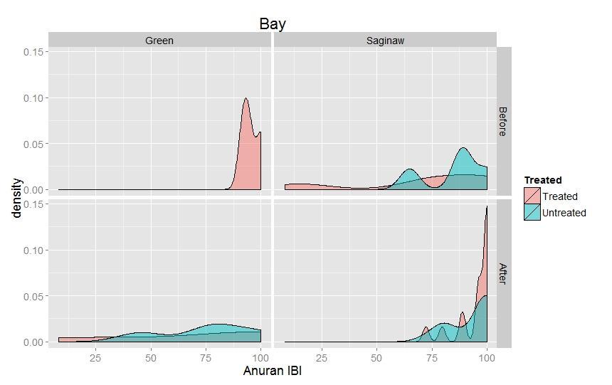
18 Field Monitoring in Green and Saginaw Bays Amphibian Diversity: Temporal Baseline Design Compared values before and after treatment using a paired t- test No significant changes in amphibian IBI Amphibian species diversity decreased significantly over time (p < 0.001) in both bays.

19 Field Monitoring in Green and Saginaw Bays Amphibian Diversity: BACI Design Mean BACI effect (estimated by two-factor mixed-effect ANOVA) was not significant for IBI or species diversity Amphibian Monitoring Takeaways Species diversity, but not IBI, shows significant decrease over time choice of indicator metric is important! Phragmites treatment appears to have no significant effect on amphibian diversity for the two years of study Highlights value of control sites: looking at change over time in treated sites alone, we might assume a negative effect of treatment, but control sites show this is not the case
 calculation Mean values are calculated for relative abundance of non-aerial foragers, relative")

20 Field Monitoring in Green and Saginaw Bays Bird Community Condition Bird Index of Biotic Integrity (IBI) calculation Mean values are calculated for relative abundance of non-aerial foragers, relative abundance of marsh nesting obligates (MNO), and species richness of area-sensitive marsh nesting obligates (AMNO; bitterns, rails, coots, cranes, etc.) Standardized and combined to create a metric ranging from 0-100

 and in the treated site at 2 pairs, with interannual variations for the")
21 Field Monitoring in Green and Saginaw Bays Bird Diversity: Spatial Matched-Pairs Design On average, paired treated and control sites did not differ significantly in bird IBI values, regardless of whether a stressor gradient was included as a covariate, whether treatment was stratified by treatment type, or whether all pairs were considered together or separated by bay At the pairwise level, IBI was consistently higher in the control site at 6 pairs (including all 3 mowing sites) and in the treated site at 2 pairs, with interannual variations for the remaining pairs


22 Field Monitoring in Green and Saginaw Bays Bird Diversity: Spatial Matched-Pairs Design Treated sites that had been mowed were associated with significantly lower bird IBI values than either unmowed treated sites or untreated sites (p = 0.03)


23 Field Monitoring in Green and Saginaw Bays Bird Diversity: Temporal Baseline Design No significant changes over time Bird Diversity: BACI Design BACI effect was not significant
24 Field Monitoring in Green and Saginaw Bays Bird Monitoring Takeaways Large year-to-year variations require either more surveys per year (pseudo-replicates) or more years of surveys to increase statistical power Indicator taxa respond differently and on different timescales. The GLCWC bird IBI emphasizes cryptic marsh nesting obligate species (rails, bitterns), which may benefit from Phragmites treatment over the long term but not the short term if mowing removes the thick emergent vegetation they prefer. More suitable sampling approach may be applied when monitoring begins prior to treatment
25 Vegetation Monitoring in Green and Saginaw Bays Measuring success: Is Phragmites cover lower in treated sites compared to similar, nearby untreated sites? Work is underway to assess Phragmites cover post-treatment and biodiversity of vegetation Qualitative analysis from field photos and aerial imagery/obliques shows mixed success


26 Saginaw Bay in 2015 Treated Site Untreated Dense Site


27 Imagery Port Austin Saginaw Bay Site 461 Treatment 461 Spring 14 9 bird species, 1 focal marsh species in vegetation IBI: 24 Control 461 Spring B 461A 7 bird species, 2 focal marsh species in vegetation IBI: : higher amphibian IBI in 461A than 461B (100 vs. 65) 2014: equal IBI


28 Phragmites in Port Austin, Site 461 Treated and mowed in 2012, photo in B Untreated Site Treated Site 461A 2014: Phragmites cover at treated site 1/3 that at control site 2015: Phragmites cover similar at the two sites 28

, likely due to lack of cover for wading birds at treated site, but many more")
29 Treatment and Control Site Comparisons in 2015 Untreated 515A Treated 515B Annual mowing since 990s, tractor herbicide in mid-summer In 2015, much higher bird IBI at untreated site (19.6 vs. 91.7), likely due to lack of cover for wading birds at treated site, but many more plant species recorded in treated site (52 vs. 23) 29


 52 Plant Species Landowners")

30 September 2015 UAV and Field Reconnaissance Saginaw Bay Shoreline Untreated Phragmites Mixed Wetland-post treatment Untreated Phragmites Treated 515B Untreated 515A 40 acre Treated site mowed since late 1990s and herbicide treated for 4 years ( ) 52 Plant Species Landowners report observing huge change in bird species post-herbicide Paired control site with untreated Phragmites 23 Plant species


31 AES Oblique 2014 Aerial Images Site 515B treated Site 515A untreated
32 Remote Sensing Mapping Satellite Sensors Radar ~24 cm wavelength L-band PALSAR-2 (10 m resolution) Optical multi-wavelength Landsat 8 (30 m resolution) Worldview-2 (1 to 2 meter resolution) Aerial Imaging AES multi-wavelength system 15 cm resolution Timely collections


33 Machine Learning Algorithms and/or Object Based Image Analysis Imagery Stack and Ancillary Data spring summer fall Classifier Land Cover Training Data Wetland Map Field Data Aerial Image Interp.


34 Moderate Resolution Radar and Optical Sensor Mapping PALSAR-2 Fall and Spring Imagery Sept and April Landsat 8 Fall and Spring Sept 9 14 and May 7 15 Large area covered by single scene Classification quick Not able to capture small (<0.25 acre) stands

35


36 July 2015 Worldview 2 Image Sub-meter WorldView-2 compared to Landsat/PALSAR-2 Mapping

37 15 cm Aerial Imagery compared to Landsat/PALSAR-2 Mapping

38 15 cm Aerial Imagery compared to Worldview and Landsat/PALSAR-2 Mapping AES June 2014 Image


39 Multi-temporal: Timing and Vegetation - Phenology Summer Fall


40 Multi-temporal, Object-based Classification Process Legend Aerial Spraying Class Name Water Emergent Wetland Tree Shrub Tree 2 Wet Prairie Phragmites Live Phragmites Detritus 2013 NAIP 2013 Spring 2013 Fall Phragmites Dead Stems Impervious Wet Meadow I Wet Meadow I Cattail Vegetation Map Legend Aerial Spraying Class Names Phragmites Live Phragmites Detritus Phragmites Dead Stems Phragmities Map

41 Field Work: Biodiversity-> Amphibian, Bird, Vegetation Legend Aerial Spraying Class Names Phragmites Live Phragmites Detritus Phragmites Dead Stems


42 Pensaukee Site Untreated Treated Coastal Strand Treated/Untreated


43 Little Tail Point Site Treated Untreated Back bay and Sand Spit Treated/Untreated


44 Ken Euers Site Treated Untreated River mouth Treated/Untreated

45 Using Maps to Inform Adaptive Management Legend Aerial Spraying Class Names Phragmites Live Phragmites Detritus Phragmites Dead Stems Areas of standing dead Phrag- cutting, mulching or prescribed burn Areas of dense thatch require mulching, raking or prescribed burn Medium sized areas Phrag Re-sprout- ATV herbicide Edges missed by herbicide treatment ATV/backpack herbicide Large Areas of dense Live Phrag- Helicopter or ATV Herbicide Small areas of Phrag Re sprout- Backpack herbicide


46 Using Maps to Inform Adaptive Management Helicopter or ATV Herbicide ATV/backpack herbicide
47 Comparison of Benefits/Limitations of Remote Sensing/Mapping at various scales Source Resolution MMU Capture Leading edges? Cost of Imagery (High-Low) Timeliness/ limitations Aerial Imaging Worldview 2 Rapid Eye/ Radarsat-2 15 cm 15 cm All Medium High 1.85 m 2 m many Free for Federal Agencies 5-8 m 0.05 ha Cloud cover and satellite orbits many High Cloud cover and satellite orbits Landsat/ PALSAR m 0.12 Ha some Landsatfree; PALSAR-2 (high) Cloud cover for Landsat and satellite orbits/collection plans
48 Summary Aerial and Satellite imagery can be very effective tools in mapping extent of Phragmites invasion, standing dead, dead fallen stems, leading edges and other vegetation cover to put treatment areas into landscape context Choice of resolution and data source needs to fit the needs of the resource managers/researchers Monitoring methods need to be developed specifically for assessing treatment effects We used the GLCWC protocols to take advantage of pretreatment data that had already been collected and for continuity Long term monitoring is really necessary to see the effects on habitat biodiversity and control sites will help to distinguish natural trends from treatment effects
49 Next Steps Complete the Vegetation Biodiversity Analysis Develop recommendations for monitoring and adaptive management based on literature/research Webinar Part 2: Applying adaptive management to the control of invasive Phragmites australis in the Midwest Thursday December 10 th 2-3 pm Working with land managers to develop a strategic approach to adaptive management for Phragmites control and restoration that includes mapping, monitoring and modeling

50 Thank you Questions?

 913-6873 lchavez@mtu.")
51 Laura Bourgeau-Chavez, Ph.D. Senior Research Scientist, Adjunct Assistant Professor The School of Forest Resources and Environmental Science Michigan Technological University Michigan Tech Research Institute 3600 Green Ct. Suite 100 Ann Arbor, MI (734) Amanda Grimm, Michigan Technological Research Institute, Jason Carlson, Applied Ecological Services,
52 Remote Sensing Series Part II: Applying Adaptive Management to the Control of non-native Phragmites australis in the Midwest Colin Brooks, Michigan Technological Research Institute December 10, 2015 Register now!

53 Great Lakes Phragmites Collaborative
Detecting and Mapping Invasive Phragmites australis in the Coastal Great Lakes with ALOS PALSAR Imagery
 Detecting and Mapping Invasive Phragmites australis in the Coastal Great Lakes with ALOS PALSAR Imagery Brian Huberty U.S Fish & Wildlife Service Region 3 Ecological Services Laura L. Bourgeau-Chavez,
Detecting and Mapping Invasive Phragmites australis in the coastal Great Lakes with ALOS PALSAR imagery
 Detecting and Mapping Invasive Phragmites australis in the coastal Great Lakes with ALOS PALSAR imagery Laura L. Bourgeau-Chavez, Kirk Scarbrough, Liza Jenkins, Kevin Riordan, Richard Powell, Colin Brooks,
Implementing Adaptive Management and Monitoring for Restoration of Invasive Phragmites Comprehensive Invasive Phragmites Management Planning: PI:
 Implementing Adaptive Management and Monitoring for Restoration of Invasive Phragmites - Funded by EPA Comprehensive Invasive Phragmites Management Planning: Funded by MISGP PI: Laura L. Bourgeau-Chavez,
Final report to the Utah Division of Water Quality. Mapping wetland vegetation in the Great Salt Lake Ecosystem
 Photo by: K.M. Kettenring Final report to the Utah Division of Water Quality Mapping wetland vegetation in the Great Salt Lake Ecosystem Karin M. Kettenring, Chad Cranney, and Eric L.G. Hazelton Utah State
Great Lakes Coastal Wetland Monitoring: Providing a Basis for Prioritizing and Evaluating Restoration
 Webinar Series 2.14.15 Great Lakes Coastal Wetland Monitoring: Providing a Basis for Prioritizing and Evaluating Restoration Webinar Agenda Coastal Wetland Priorities under the GLRI Kevin O Donnell, U.S.
Protecting our Natural Areas from Phragmites and other Invaders
 Protecting our Natural Areas from Phragmites and other Invaders by Laurie Kaufman www.stewardshipnetwork.org/midmich Asclepias incarnata, photo by Laurie Kaufman What do we mean by Invasive Species? The
Phragmites australis control projects at Long Point and Rondeau
 Ministry of Natural Resources and Forestry Phragmites australis control projects at Long Point and Rondeau Emergency Use Registration for application of herbicide over water Saturday April 22, 2017 Dustin
American Bittern Minnesota Conservation Summary
 Credit Jim Williams American Bittern Minnesota Conservation Summary Audubon Minnesota Spring 2014 The Blueprint for Minnesota Bird Conservation is a project of Audubon Minnesota written by Lee A. Pfannmuller
Lake St. Clair Coastal Wetlands in 2050: Modelling Wetland Community Responses to Climate Change Water Level Scenarios
 Lake St. Clair Coastal Wetlands in 2050: Modelling Wetland Community Responses to Climate Change Water Level Scenarios Joel W. Ingram 1, Linda D. Mortsch 2, Susan E. Doka 3, Andrea J. Hebb 2, Shawn W.
Treating Phragmites in High Quality Natural Communities
 Treating Phragmites in High Quality Natural Communities Phyllis Higman Michigan Natural Features Inventory Thanks to Sue Tangora, Mark Sargent, Brian Piccolo, Pam Grassmick, Suzan Campbell, Daria Hyde,
Oregon Dunes National Recreation Area BCS Number: 47-5
 Oregon Dunes National Recreation Area BCS Number: 47-5 ***NOTE: We were unable to determine all necessary information for this site description. If you would like to contribute the needed information to
Beaver Island Archipelago: Invasive Species Control Final Report Submitted by:
 Beaver Island Archipelago: Invasive Species Control Final Report Submitted by: 4371 N Long Lake Rd Traverse City, MI 49684 wildlife@wildlifewetlands.com (231) 943-0762 Project Plan and Schedule 2014 Treatment
A Landowner s Guide to. Jennifer M. Granholm, Governor. Michigan Department of Environmental Quality. Michigan DNR. Dave Brenner
 Jennifer M. Granholm, Governor Steven E. Chester, Director Michigan Department of Environmental Quality www.michigan.gov/deq Todd Marsee, Michigan Sea Grant Dave Brenner A Landowner s Guide to Phragmites
Klamath Marsh National Wildlife Refuge BCS number: 48-16
 Oregon Coordinated Aquatic Bird Monitoring: Description of Important Aquatic Bird Site Klamath Marsh National Wildlife Refuge BCS number: 48-16 Site description author(s) Carol Damberg, Klamath Marsh NWR
Baskett Slough National Wildlife Refuge BCS number: 47-4
 Baskett Slough National Wildlife Refuge BCS number: 47-4 Site description author(s) Daphne E. Swope, Research and Monitoring Team, Klamath Bird Observatory Primary contact for this site N/A Location (UTM)
Control of Non native Phragmites within the Great Lakes Basins: A Case Study in Invasive Species Strategic Planning and Implementation
 Thursday, April 6 2017 Mindful Management of Aquatic Invasive Species Control of Non native Phragmites within the Great Lakes Basins: A Case Study in Invasive Species Strategic Planning and Implementation
Invasive Phragmites Control at Long Point Region and Rondeau Provincial Park
 Invasive Phragmites Control at Long Point Region and Rondeau Provincial Park Implementation Plan Ministry of Natural Resources and Forestry Natural Resources Conservation Policy Branch, Natural Heritage
Relicensing Study 3.5.1
 Relicensing Study 3.5.1 BASELINE INVENTORY OF WETLAND, RIPARIAN AND LITTORAL HABITAT IN THE TURNERS FALLS IMPOUNDMENT, AND ASSESSMENT OF OPERATIONAL IMPACTS ON SPECIAL-STATUS SPECIES Updated Study Report
Oak Woodlands and Chaparral
 Oak Woodlands and Chaparral Aligning chaparral-associated bird needs with oak woodland restoration and fuel reduction in southwest Oregon and northern California Why conservation is needed Oak woodland
Non-native Phragmites in the Midwest: Status & Control. Brock Woods UWEX & WDNR (608)
") Non-native Phragmites in the Midwest: Status & Control Brock Woods UWEX & WDNR (608) 266-2554 Brock.woods@wi.gov Phragmites threatens waters & wetlands everywhere Reduces plant & animal diversity Reduces
Non-native Phragmites in the Midwest: Status & Control Brock Woods UWEX & WDNR (608) 266-2554 Brock.woods@wi.gov Phragmites threatens waters & wetlands everywhere Reduces plant & animal diversity Reduces
Ladd Marsh Wildlife Area BCS number: 49-3
 Oregon Coordinated Aquatic Bird Monitoring: Description of Important Aquatic Bird Site Ladd Marsh Wildlife Area BCS number: 49-3 Site description author M. Cathy Nowak, Ladd Marsh Wildlife Area Biologist
Mud Slough Wetland Reserve BCS number: 47-19
 Mud Slough Wetland Reserve BCS number: 47-19 ***NOTE: We were unable to determine all necessary information for this site description. If you would like to contribute the needed information to this description,
Blue-winged Teal. Blue-winged Teal Minnesota Conservation Summary
 Credit Rebecca Field Blue-winged Teal Blue-winged Teal Minnesota Conservation Summary Audubon Minnesota Spring 2014 The Blueprint for Minnesota Bird Conservation is a project of Audubon Minnesota written
Overview and Identification of Introduced Exotic and Native Forms of Common Reed (Phragmites australis)
") Overview and Identification of Introduced Exotic and Native Forms of Common Reed (Phragmites australis) Prepared by Jil M Swearingen, National Park Service June 14, 2006 Description Phragmites is a tall,
Overview and Identification of Introduced Exotic and Native Forms of Common Reed (Phragmites australis) Prepared by Jil M Swearingen, National Park Service June 14, 2006 Description Phragmites is a tall,
Phragmites australis invasion into disturbances in Chesapeake Bay tidal wetlands: Dispersal, colonization, fitness, and restoration
 Phragmites australis invasion into disturbances in Chesapeake Bay tidal wetlands: Dispersal, colonization, fitness, and restoration Karin Kettenring 1,4, Eric Hazelton 1,4, Sally Gallagher 2,4, Heather
Visualizing a Pixel. Simulate a Sensor s View from Space. In this activity, you will:
 Simulate a Sensor s View from Space In this activity, you will: Measure and mark pixel boundaries Learn about spatial resolution, pixels, and satellite imagery Classify land cover types Gain exposure to
Wanaket Wildlife Area BCS number: 48-30
 Oregon Coordinated Aquatic Bird Monitoring: Description of Important Aquatic Bird Site Wanaket Wildlife Area BCS number: 48-30 Site description author(s) M. Cathy Nowak, ODFW, Ladd Marsh Wildlife Area
Fernhill Wetlands BCS number: 47-13
 Fernhill Wetlands BCS number: 47-13 ***NOTE: We were unable to determine all necessary information for this site description. If you would like to contribute the needed information to this description,
Riparian Conservation Project Monitoring and Avian Habitat in Colorado
 Riparian Conservation Project Monitoring and Avian Habitat in Colorado October 14, 2004 Colorado Riparian Association Alison Banks Cariveau Rocky Mountain Bird Observatory Conserving birds of the Rocky
Smith River Mouth BCS number: 86-6
 Smith River Mouth BCS number: 86-6 ***NOTE: We were unable to determine all necessary information for this site description. If you would like to contribute the needed information to this description,
FACT SHEET: GIANT REED
 FACT SHEET: GIANT REED Common Reed Phragmites australis (Cav.) Trin. ex Steud. Grass family (Poaceae) NATIVE RANGE Eurasia DESCRIPTION Common reed, or Phragmites, is a tall, perennial grass that can grow
Jackson Bottom Wetlands Preserve BCS Number: 47-14
 Jackson Bottom Wetlands Preserve BCS Number: 47-14 Site description author(s) Greg Gillson, Jackson Bottom Wetlands Preserve Primary contact for this site Ed Becker, Natural Resources Manager, Jackson
NRS 415 Remote Sensing of Environment
 NRS 415 Remote Sensing of Environment 1 High Oblique Perspective (Side) Low Oblique Perspective (Relief) 2 Aerial Perspective (See What s Hidden) An example of high spatial resolution true color remote
Automated Damage Analysis from Overhead Imagery
 Automated Damage Analysis from Overhead Imagery EVAN JONES ANDRE COLEMAN SHARI MATZNER Pacific Northwest National Laboratory 1 PNNL FY2015 at a Glance $955 million in R&D expenditures 4,400 scientists,
Monitoring the vegetation success of a rehabilitated mine site using multispectral UAV imagery. Tim Whiteside & Renée Bartolo, eriss
 Monitoring the vegetation success of a rehabilitated mine site using multispectral UAV imagery Tim Whiteside & Renée Bartolo, eriss About the Supervising Scientist Main roles Working to protect the environment
Application of Satellite Remote Sensing for Natural Disasters Observation
 Application of Satellite Remote Sensing for Natural Disasters Observation Prof. Krištof Oštir, Ph.D. University of Ljubljana Faculty of Civil and Geodetic Engineering Outline Earth observation current
Red-breasted Merganser Minnesota Conservation Summary
 Credit Jim Williams Red-breasted Merganser Minnesota Conservation Summary Audubon Minnesota Spring 2014 The Blueprint for Minnesota Bird Conservation is a project of Audubon Minnesota written by Lee A.
Introduction. Introduction. Introduction. Introduction. Introduction
 Identifying habitat change and conservation threats with satellite imagery Extinction crisis Volker Radeloff Department of Forest Ecology and Management Extinction crisis Extinction crisis Conservationists
18 July Keith Greer SANDAG 401 B Street, Suite 800 San Diego, CA Subject: Mission Bay Park Project Quarterly Report
 18 July 2012 Keith Greer SANDAG 401 B Street, Suite 800 San Diego, CA 92101 Subject: Mission Bay Park Project Quarterly Report Dates Reporting: April 6 th -July 6 th, 2012 Project Summary: The project
Pre-Cutting (before the first chemical treatment) My biggest mistake in 10 years of Phragmites Control
 My biggest mistake in 10 years of Phragmites Control") Pre-Cutting, Multi-treatments and Project Scale July 2015 The initial problem By Bob Williams Bob@Phragmites.org Phragmites.org 2 The later problem The Solution Maximum control before native plants begin
Pre-Cutting, Multi-treatments and Project Scale July 2015 The initial problem By Bob Williams Bob@Phragmites.org Phragmites.org 2 The later problem The Solution Maximum control before native plants begin
Black-crowned Night-heron Minnesota Conservation Summary
 Credit Deborah Reynolds Black-crowned Night-heron Minnesota Conservation Summary Audubon Minnesota Spring 2014 The Blueprint for Minnesota Bird Conservation is a project of Audubon Minnesota written by
Research Background: Students collecting salinity data at a point along the transect. The tall, tan grass is invasive Phragmites.
 Can a salt marsh recover after restoration? Featured scientists: Liz Duff from Mass Audubon, Eric Hutchins from NOAA, & Rockport Middle School science club. Written by: Bob Allia, Cindy Richmond, & Dave
Smith and Bybee Wetlands Natural Area BCS number 47-33
 Smith and Bybee Wetlands Natural Area BCS number 47-33 Site description author(s) Elaine Stewart, Smith and Bybee Lakes Wildlife Area Manager Danielle Morris, Research and Monitoring Team, Klamath Bird
Catch the Citizen Science Buzz!
 Catch the Citizen Science Buzz! Utilizing Citizen Science to Inform Land Management Decisions Tina Stephens, Volunteer and Outreach Coordinator Becky Gajewski, Stewardship Specialist Why are you here?
Chesapeake Bay adaptation Designing marshes for David Curson, National Audubon Society Erik Meyers, The Conservation Fund
 Chesapeake Bay adaptation Designing marshes for 2100 David Curson, National Audubon Society Erik Meyers, The Conservation Fund Blackwater National Wildlife Refuge Maryland s Everglades Biological Resources:
Project Updates
 2013 2014 Project Updates Serving Keweenaw, Houghton, Gogebic, Ontonagon, Iron, Baraga, Alger, Delta, Dickinson, Marquette, Menominee, Schoolcraft, Chippewa, Luce, and Mackinac Counties UP RC&D Council
A Project to Map and Monitor Baldcypress Forests in Coastal Louisiana, using Landsat, MODIS, and ASTER Satellite Data
 A Project to Map and Monitor Baldcypress Forests in Coastal Louisiana, using Landsat, MODIS, and ASTER Satellite Data Presented to the 2012 Louisiana RS/GIS Workshop by: Joseph Spruce, Computer Sciences
Trinity River Bird and Vegetation Monitoring: 2015 Report Card
 Trinity River Bird and Vegetation Monitoring: 2015 Report Card Ian Ausprey 2016 KBO 2016 Frank Lospalluto 2016 Frank Lospalluto 2016 Background The Trinity River Restoration Program (TRRP) was formed in
AGuide to the. Control and Management. INVASIVE phragmites
 AGuide to the Control and Management INVASIVE phragmites . A Guide to the Control and Management of invasive phragmites Partial funding for this program is supported by a Cooperative Agreement from the
Marsh Bird and Amphibian Communities in the Thunder Bay AOC,
 Marsh and Amphibian Communities in the Thunder Bay AOC, 995. Purpose of the MMP The Marsh Monitoring Program (MMP) was established to provide baseline surveys of marsh bird and amphibian populations and
MULTI-TEMPORAL IMAGE ANALYSIS OF THE COASTAL WATERSHED, NH INTRODUCTION
 MULTI-TEMPORAL IMAGE ANALYSIS OF THE COASTAL WATERSHED, NH Meghan Graham MacLean, PhD Student Alexis M. Rudko, MS Student Dr. Russell G. Congalton, Professor Department of Natural Resources and the Environment
PART FIVE: Grassland and Field Habitat Management
 PART FIVE: Grassland and Field Habitat Management PAGE 64 15. GRASSLAND HABITAT MANAGEMENT Some of Vermont s most imperiled birds rely on the fields that many Vermonters manage as part of homes and farms.
MULTI-TEMPORAL SATELLITE IMAGES WITH BATHYMETRY CORRECTION FOR MAPPING AND ASSESSING SEAGRASS BED CHANGES IN DONGSHA ATOLL
 MULTI-TEMPORAL SATELLITE IMAGES WITH BATHYMETRY CORRECTION FOR MAPPING AND ASSESSING SEAGRASS BED CHANGES IN DONGSHA ATOLL Chih -Yuan Lin and Hsuan Ren Center for Space and Remote Sensing Research, National
Background on Invasive Phragmites. Presented By: Sue Tangora Date: 03/29/11
 Background on Invasive Phragmites Presented By: Sue Tangora Date: 03/29/11 Introduction Dispersal Distribution Background on Invasive Phragmites Native vs. non-native phragmites Impacts Challenges Introduction
Hydrologically induced seasonal changes in cypress forest aquatic fauna communities. Shawn E. Liston, Nicole M. Katin & Jerome J.
 Hydrologically induced seasonal changes in cypress forest aquatic fauna communities Shawn E. Liston, Nicole M. Katin & Jerome J. Lorenz The Big Cypress Region Little is known about the long-term history
Northern Remnant of the. Everglades Ecosystem. Sylvia R. Pelizza
 Arthur R. Marshall Loxahatchee Nation nal Wildlife Refuge Northern Remnant of the Everglades Ecosystem Sylvia R. Pelizza Project tleader National Wildli fe Refuge System Administered i d by the U.S. Fish
Relationship Between Landsat 8 Spectral Reflectance and Chlorophyll-a in Grand Lake, Oklahoma
 Relationship Between Landsat 8 Spectral Reflectance and Chlorophyll-a in Grand Lake, Oklahoma Presented by: Abu Mansaray Research Team Dr. Andrew Dzialowski (PI), Oklahoma State University Dr. Scott Stoodley
Costal region of northern Peru, the pacific equatorial dry forest there is recognised for its unique endemic biodiversity
 S.Baena@kew.org http://www.kew.org/gis/ Costal region of northern Peru, the pacific equatorial dry forest there is recognised for its unique endemic biodiversity Highly threatened ecosystem affected by
Tualatin River NWR and Wapato Lake BCS number: 47-37
 Tualatin River NWR and Wapato Lake BCS number: 47-37 ***NOTE: We were unable to determine all necessary information for this site description. If you would like to contribute the needed information to
T.S Roberts Bird Sanctuary Improvements Project
 T.S Roberts Bird Sanctuary Improvements Project Dr. David Zumeta Ornithology and Forest Habitat Expert Jason Aune Landscape Architect, AFLA Tyler Pederson Project Manager Michael Schroeder Assistant Superintendent
2016 Winter. / ASF News & Notes / 2016 Winter
 Home Get Data Datasets Data Tools About SAR News About ASF / ASF News & Notes / 2016 Winter Latest News 2016 Winter 2014 Fall 2014 Spring 2013 Summer 2013 Spring 2012 Winter 2012 Fall 2012 Summer 2012
2017 Monarch Butterfly Conservation Fund Grant Slate
 2017 Monarch Butterfly Conservation Fund Grant Slate NFWF CONTACT Todd Hogrefe Director, Central Regional Office todd.hogrefe@nfwf.org 612-564-7286 PARTNERS Monarch butterflies ABOUT NFWF The National
Warner Wetlands / Warner Valley BCS number: 48-31
 Oregon Coordinated Aquatic Bird Monitoring: Description of Important Aquatic Bird Site Warner Wetlands / Warner Valley BCS number: 48-31 Site description author(s) Vernon Stofleth, Lakeview BLM District
Malheur National Wildlife Refuge BCS number: 48-18
 Oregon Coordinated Aquatic Bird Monitoring: Description of Important Aquatic Bird Site Malheur National Wildlife Refuge BCS number: 48-18 Site description author(s) Sally Hall, Volunteer, Malheur NWR Roger
ASSESSING HABITAT QUALITY FOR PRIORITY WILDLIFE SPECIES IN COLORADO WETLANDS
 C O L O R A D O P A R K S Dabbling Ducks & W I L D L I F E GADWALL TOM KOERNER, USFWS / AMERICAN WIGEON BILL GRACEY NORTHERN PINTAIL GEORGIA HART / MALLARD MICHAEL MENEFEE, CNHP / ALL TEAL PHOTOS TOM KOERNER,
Overview of how remote sensing is used by the wildland fire community.
 Overview of how remote sensing is used by the wildland fire community. Presented to the ASEN 6210 Remote Sensing Seminar on 2/18/04 by: Jeff Baranyi ESRI Denver Reported by Gary Fager. Images are from
PILOTING A DECISION SUPPORT TOOL (DST) FOR MAPPING CYANOBACTERIAL HARMFUL ALGAL BLOOMS (CHABS) TO SUPPORT PUBLIC HEALTH AND RESOURCE MANAGEMENT.
 FOR MAPPING CYANOBACTERIAL HARMFUL ALGAL BLOOMS (CHABS) TO SUPPORT PUBLIC HEALTH AND RESOURCE MANAGEMENT.") PILOTING A DECISION SUPPORT TOOL (DST) FOR MAPPING CYANOBACTERIAL HARMFUL ALGAL BLOOMS (CHABS) TO SUPPORT PUBLIC HEALTH AND RESOURCE MANAGEMENT. Nathan Torbick, Applied Geosolutions Scott Stoodley, Director,
PILOTING A DECISION SUPPORT TOOL (DST) FOR MAPPING CYANOBACTERIAL HARMFUL ALGAL BLOOMS (CHABS) TO SUPPORT PUBLIC HEALTH AND RESOURCE MANAGEMENT. Nathan Torbick, Applied Geosolutions Scott Stoodley, Director,
Remote Sensing Part 3 Examples & Applications
 Remote Sensing Part 3 Examples & Applications Review: Spectral Signatures Review: Spectral Resolution Review: Computer Display of Remote Sensing Images Individual bands of satellite data are mapped to
Varying levels of bird activity within a forest understory dominated by the invasive glossy buckthorn (Rhamnus frangula)
") 1 Varying levels of bird activity within a forest understory dominated by the invasive glossy buckthorn (Rhamnus frangula) Tamara M. Baker Biology Department, College of Letters and Sciences, University
1 Varying levels of bird activity within a forest understory dominated by the invasive glossy buckthorn (Rhamnus frangula) Tamara M. Baker Biology Department, College of Letters and Sciences, University
Green/Blue Metrics Meeting June 20, 2017 Summary
 Short round table introductions of participants Paul Villenueve, Carleton, Co-lead Green/Blue, Matilda van den Bosch, UBC, Co-lead Green/Blue Dan Crouse, UNB Lorien Nesbitt, UBC Audrey Smargiassi, Uof
Matagorda Island Marsh Restoration An Adaptive Management Approach by Coastal Bend Bays & Estuaries Program
 Matagorda Island Marsh Restoration An Adaptive Management Approach by Coastal Bend Bays & Estuaries Program 1957: After Levees 1930: Before Levees Matagorda Island: Site Location Texas Coastal Bend Calhoun
Sauvie Island Wildlife Area BCS number: 47-28
 Sauvie Island Wildlife Area BCS number: 47-28 Site description author(s) Mark Nebeker, Oregon Department of Fish and Wildlife, Sauvie Island Wildlife Area Manager Primary contact for this site Mark Nebeker,
Title Marsh Bird Habitat Restoration and Management on Private and Public land in Arkansas Mississippi Alluvial Valley
 Title Marsh Bird Habitat Restoration and Management on Private and Public land in Arkansas Mississippi Alluvial Valley Project Summary: Changes in habitat and hydrology have caused serious declines in
Mapping Open Water Bodies with Optical Remote Sensing
 Mapping Open Water Bodies with Optical Remote Sensing M. O Donnell 1,2 and E. Podest 1 1.Jet Propulsion Laboratory, California Institute of Technology 2 Alliance Gertz-Ressler High School, Los Angeles,
Phragmites Identification, Ecology, and Management
 Phragmites Identification, Ecology, and Management Noelle Orloff Montana State University Montana Weed Control Association Annual Conference January 13, 2016 Outline Phragmites history, competitive interactions,
MAPPING OPTIONS TO TRACK INVASIVE PHRAGMITES AUSTRALIS IN THE GREAT LAKES BASIN IN CANADA
 3 rd International Conference - Water resources and wetlands. 8-10 September, 2014 Tulcea (Romania); Available online at http://www.limnology.ro/wrw2016/proceedings.html Editors: Petre Gâştescu, Petre
Wisconsin Department of Natural Resources
 Managing Invasive Plants on Private Lands; A Multi-partner, Large-scale Approach to Control Phragmites australis (Common Reed) and Leymus arenarius (Lyme Grass) Joe Henry District Ecologist, Bureau of
Species Response to Habitat Restoration and Management in San Francisco Bay
 Species Response to Habitat Restoration and Management in San Francisco Bay Joy Albertson, U.S. Fish and Wildlife Service October 11, 2017 2017 State of the San Francisco Estuary Conference Past (~1850)
Chapter 15.11: Phragmites Common Reed
 Chapter 15.11: Phragmites Common Reed Jack M. Whetstone: Clemson University, Georgetown SC; jwhtstn@clemson.edu Phragmites australis (Cav.) Trin. Ex Steud.; emergent plant in the Poaceae (grass) family
Division: Habitat and Species Conservation Authors: Claire Sunquist Blunden and Brad Gruver
 Division: Habitat and Species Conservation Authors: Claire Sunquist Blunden and Brad Gruver Report date: December 13, 2018 All photos by FWC unless otherwise acknowledged Presenting 6 new guidelines 1
Killin Wetland (Cedar Canyon Marsh) BCS number: 47-15
 BCS number: 47-15") Killin Wetland (Cedar Canyon Marsh) BCS number: 47-15 ***NOTE: We were unable to determine all necessary information for this site description. If you would like to contribute the needed information to
Killin Wetland (Cedar Canyon Marsh) BCS number: 47-15 ***NOTE: We were unable to determine all necessary information for this site description. If you would like to contribute the needed information to
McKay Creek National Wildlife Refuge BCS number: 48-19
 Oregon Coordinated Aquatic Bird Monitoring: Description of Important Aquatic Bird Site McKay Creek National Wildlife Refuge BCS number: 48-19 Site description author(s) Howard Browers, Supervisory Wildlife
Environment and Natural Resources Trust Fund 2019 Request for Proposals (RFP)
") Environment and Natural Resources Trust Fund 2019 Request for Proposals (RFP) Project Title: Implementing Conservation Plans for Avian Species of Concern Category: H. Proposals seeking 200,000 or less
Environment and Natural Resources Trust Fund 2019 Request for Proposals (RFP) Project Title: Implementing Conservation Plans for Avian Species of Concern Category: H. Proposals seeking 200,000 or less
Implementing the pilot Federal Marshbird Monitoring Program in Wisconsin
 Implementing the pilot Federal Marshbird Monitoring Program in Wisconsin Initial results and future plans Andy Paulios and Ryan Brady: WI-DNR Mark Seamans: USFWS Patuxent SECRETIVE MARSHBIRDS Not well-monitored
Quantifying Change in. Quality Effects on a. Wetland Extent & Wetland. Western and Clark s Grebe Breeding Population
 Quantifying Change in Wetland Extent & Wetland Quality Effects on a Western and Clark s Grebe Breeding Population Eagle Lake, CA: 1998-2010 Renée E. Robison 1, Daniel W. Anderson 2,3, and Kristofer M.
Dr. P Shanmugam. Associate Professor Department of Ocean Engineering Indian Institute of Technology (IIT) Madras INDIA
 Madras INDIA") Dr. P Shanmugam Associate Professor Department of Ocean Engineering Indian Institute of Technology (IIT) Madras INDIA Biography Ph.D (Remote Sensing and Image Processing for Coastal Studies) - Anna University,
Dr. P Shanmugam Associate Professor Department of Ocean Engineering Indian Institute of Technology (IIT) Madras INDIA Biography Ph.D (Remote Sensing and Image Processing for Coastal Studies) - Anna University,
1.0 Performance Measure Title Wetland Trophic Relationships Wading Bird Nesting Patterns. 2.0 Justification
 1.0 Performance Measure Title Wetland Trophic Relationships Wading Bird Nesting Patterns Last Date Revised: December 2006 2.0 Justification Over the past several decades, wading bird reproduction in the
North American Wetlands Conservation Act
 North American Wetlands Conservation Act WISCONSIN Wisconsin currently has 85 NAWCA projects either completed or underway. These projects have conserved a total of 151,974 acres of wildlife habitat. NAWCA
Data acquisition and access for the Congo Basin
 MRV Joint Workshop 22-24 June 2010, Guadalajara, Jalisco Mexico Data acquisition and access for the Congo Basin Landing Mané 1, Michael Brady 2, Chris Justice 3 and Alice Altstatt 3 1) Satellite Observatory
Tahkenitch Creek Estuary BCS number: 47-35
 Tahkenitch Creek Estuary BCS number: 47-35 ***NOTE: We were unable to determine all necessary information for this site description. If you would like to contribute the needed information to this description,
Grey County Natural Heritage System Study
 Grey County Natural Heritage System Study Green in Grey Technical Advisory Committee Meeting #1 February 25, 2015 225 Labrador Drive, Unit 1, Waterloo, Ontario, N2K 4M8 Tel: (519) 725-2227 Web: www.nrsi.on.ca
Oil Spill Funds and the Opportunities they Present for Galveston Bay
 Oil Spill Funds and the Opportunities they Present for Galveston Bay A presentation to Texas Environmental Grantmakers Group By Bob Stokes, President, Galveston Bay Foundation Friday, October 31, 2014
APCAS/10/21 April 2010 ASIA AND PACIFIC COMMISSION ON AGRICULTURAL STATISTICS TWENTY-THIRD SESSION. Siem Reap, Cambodia, April 2010
 APCAS/10/21 April 2010 Agenda Item 8 ASIA AND PACIFIC COMMISSION ON AGRICULTURAL STATISTICS TWENTY-THIRD SESSION Siem Reap, Cambodia, 26-30 April 2010 The Use of Remote Sensing for Area Estimation by Robert
Conservation Objectives
 Conservation Objectives Overall Conservation Goal: Sustain the distribution, diversity, and abundance of native landbird populations and their habitats in Ontario's Bird Conservation Regions High Level
In late April of 1986 a nuclear accident damaged a reactor at the Chernobyl nuclear
 CHERNOBYL NUCLEAR POWER PLANT ACCIDENT Long Term Effects on Land Use Patterns Project Introduction: In late April of 1986 a nuclear accident damaged a reactor at the Chernobyl nuclear power plant in Ukraine.
Reducing NN Phragmites and Tall Manna Grass Threats to Your Waters! Brock Woods UWEX & WDNR (608)
") Reducing NN Phragmites and Tall Manna Grass Threats to Your Waters! Brock Woods UWEX & WDNR (608) 266-2554 Brock.woods@wi.gov Phragmites australis in Wisconsin (Common reed grass) Native Phrag grows statewide
Reducing NN Phragmites and Tall Manna Grass Threats to Your Waters! Brock Woods UWEX & WDNR (608) 266-2554 Brock.woods@wi.gov Phragmites australis in Wisconsin (Common reed grass) Native Phrag grows statewide
USING GENETIC TESTING TO INFORM MANAGEMENT OF PHRAGMITES IN COLORADO. Patty York EDRR & List A Specialist Colorado Dept of Agriculture
 USING GENETIC TESTING TO INFORM MANAGEMENT OF PHRAGMITES IN COLORADO Patty York EDRR & List A Specialist Colorado Dept of Agriculture THREE SUBSPECIES IN THE US Phragmites australis subspecies americanus
Land Cover Analysis to Determine Areas of Clear-cut and Forest Cover in Olney, Montana. Geob 373 Remote Sensing. Dr Andreas Varhola, Kathry De Rego
 1 Land Cover Analysis to Determine Areas of Clear-cut and Forest Cover in Olney, Montana Geob 373 Remote Sensing Dr Andreas Varhola, Kathry De Rego Zhu an Lim (14292149) L2B 17 Apr 2016 2 Abstract Montana
Sandhill Cranes and Waterfowl of the North Platte River Valley: Evaluation of Habitat Selection to Guide Conservation Delivery
 Sandhill Cranes and Waterfowl of the North Platte River Valley: Evaluation of Habitat Selection to Guide Conservation Delivery { Emily Munter, Wildlife Biologist U.S. Fish and Wildlife Service Nebraska
Project Summary. Predicting waterbird nest distributions on the Yukon-Kuskokwim Delta of Alaska
 Project Summary 1. PROJECT INFORMATION Title Project ID Predicting waterbird nest distributions on the Yukon-Kuskokwim Delta of Alaska WA2012_22 Project Period July 1, 2012 to June 30, 2014 Report submission