CROSSTOWN PARKWAY/I-95 INTERCHANGE PD&E STUDY ENDANGERED SPECIES BIOLOGICAL ASSESSMENT EXECUTIVE SUMMARY
|
|
|
- Milo Spencer
- 6 years ago
- Views:
Transcription
1
2
3 CROSSTOWN PARKWAY/I-95 INTERCHANGE PD&E STUDY ENDANGERED SPECIES BIOLOGICAL ASSESSMENT EXECUTIVE SUMMARY The City of Port St. Lucie (City) is conducting a Project Development and Environment (PD&E) Study to evaluate new interchange ramps at Crosstown Parkway and Interstate 95 (I-95) in the City, St. Lucie County, Florida. The need to provide connections to the interstate highway system is driven by extraordinary growth in the City, and proposed growth west of I-95. The forecasted future demands reflect an additional 200,000 people by 2030 and over 26 million square feet of non-residential development just within the City limits of Port St Lucie and in the newly annexed areas west of I-95. This will add several hundred thousand new vehicles each day to the area roadway and interchange network. Associated with the growth being approved by the City for areas west of I-95, a series of new roadways are proposed to be constructed by 2010 with ultimate 2025 roadway improvements. By 2025 Crosstown Parkway is programmed as a four-lane roadway from Range Line Road to west of Community Boulevard where it will transition to a six-lane roadway and continue as a six-lane facility to Floresta Drive. The proposed bridge over I-95 will be constructed as a six-lane facility. A new bridge at Crosstown Parkway and Florida s Turnpike is currently under construction. Although most of these improvements are programmed for 2010, the City will be advancing the proposed Crosstown Parkway improvements to be completed by In addition, the City has accelerated selected components of the 2025 improvements including six-laning Becker Road just east of I-95 to just west of Community Boulevard. For this PD&E Study, all of these improvements are planned to be complete by 2010, and for this study will be considered existing and will define the No Build Alternative for all study years. Using the proposed roadway network outlined above, a System Interchange Justification Report (SIJR) dated March 27, 2006, was prepared for this project. The report recommended a tight diamond interchange at Crosstown Parkway and I-95, as well as a tight diamond interchange at Becker Road and I- 95. The SIJR evaluated the complete I-95 interchange system from St. Lucie West Boulevard south to Martin Highway (SR 714), and determined that the two proposed interchange locations along with the three existing interchanges would meet the projected future traffic demand in the area. The purpose of this report is to present the findings of an endangered species biological assessment for the proposed interchange area. The assessment was conducted using field investigations, agency coordination, and mapped resources. Field surveys were conducted on November 5, 2004, March 11, 2005, and April 10, The surveys qualitatively documented the existing flora and fauna throughout the study area, to assess the land use patterns in the project area, and to examine the habitats for threatened and endangered species. Most of the lands in the northern half of the project area are highly disturbed. The northwestern quadrant is under development for residential land uses. Much of the upland habitat in the southern quadrants can be described as Scrubby Flatwoods. Three depression wetlands are located within the flatwoods habitats. There are no recorded occurrences of listed threatened or endangered species within the project area. A list of potential plant and animal species that could occur in the project area was examined to assess their likelihood of occurrence. Fifteen plant and eighteen animal species protected by the US Fish and Wildlife Service (FWS), the Florida Fish and Wildlife Conservation Commission (FFWCC), or the Florida Executive Summary i
4 CROSSTOWN PARKWAY/I-95 INTERCHANGE PD&E STUDY ENDANGERED SPECIES BIOLOGICAL ASSESSMENT Department of Agriculture and Consumer Services were determined to potentially occur within the project area. No State or Federal listed plant species were observed and the specialized habitat that would support the listed plants was not present in the project area. The proposed project would have no effect on any listed plant species. The exotic dominated scrubby flatwoods and the depression wetlands could potentially provide habitat for several listed wildlife species. These include the gopher tortoise, eastern indigo snake, gopher frog, Florida pine snake, Florida mouse, American alligator, little blue heron, reddish egret, snowy egret, tricolored heron, white ibis and wood stork. The project area is within the core foraging area of documented nesting colonies of wood storks. The C-24 Canal and the freshwater wetlands may provide foraging or resting habitat for wading birds and wood storks. The habitat provided by the C-24 Canal would not be affected by the construction of the interchange. The wetlands would be minimally affected. The proposed project may affect, but is not likely to adversely affect these State and Federal listed animal species. However, no State or Federal listed wildlife species were observed during field investigations. Executive Summary ii
5 CROSSTOWN PARKWAY/I-95 INTERCHANGE PD&E STUDY ENDANGERED SPECIES BIOLOGICAL ASSESSMENT TABLE OF CONTENTS Section Description Page Number 1.0 INTRODUCTION PROJECT NEED PROJECT DESCRIPTION ASSESSMENT METHODOLOGY HABITAT DESCRIPTIONS FRESHWATER WETLANDS SURFACE WATERS AND AQUATIC COMMUNITIES TERRESTRIAL HABITATS LISTED SPECIES LISTED PLANTS Lakela s Mint (Dicerandra immaculata) Tiny Polygala (Polygala smallii) Four-petal Pawpaw (Asimina tetramera) Large-flowered False Rosemary (Conradina grandiflora) Airplants (Tillandsia spp.) Perforated Reindeer Moss (Cladonia perforata) Florida Butterfly Orchid (Encyclia tampensis) Nodding Pinweed (Lechea cernua) Hand Fern (Ophioglossum palmatum) Erect Prickly Pear (Opuntia stricta) Cinnamon Fern (Osmunda cinnomonea) and Royal Fern (Osmunda regalis) LISTED ANIMALS Gopher Tortoise (Gopherus polyphemus) Eastern Indigo Snake (Drymarchon corais couperi) Gopher Frog (Rana capito) Florida Pine Snake (Pituophis melanoleucus mugitis) Florida Mouse (Podomys floridanus) American Alligator (Alligator mississippiensis) Florida Scrub Jay (Aphelocoma coerulescens) Red-cockaded Woodpecker (Picoides borealis) Herons Wood Stork (Mycteria americana) Bald Eagle (Haliaeetus lecocephalus) Osprey (Pandion haliaetus) Audubon s Crested Caracara (Polyborus plancus audobonii) Arctic Peregrine Falcon (Falco peregrinus tundrius) Southeastern American Kestrel (Falco sparverius paulus) Everglades Snail Kite (Rostrhamus sociabilis plumbeus) Sherman s Fox Squirrel (Sciurus niger shermanii) IMPACT ANALYSIS COORDINATION BIBLIOGRAPHY Table of Contents iii
6 CROSSTOWN PARKWAY/I-95 INTERCHANGE PD&E STUDY ENDANGERED SPECIES BIOLOGICAL ASSESSMENT Table of Contents (continued) LIST OF FIGURES Section Description Page Number FIGURE 1.1 PROJECT LOCATION... 3 FIGURE 2.1 YEAR 2025 DEVELOPMENTS... 4 FIGURE 2.2 YEAR 2010 WESTERN ANNEXATION ROADWAYS... 5 FIGURE 2.3 YEAR 2025 WESTERN ANNEXATION ROADWAYS... 6 FIGURE 2.4 EXISTING ROADWAY CONDITIONS... 7 FIGURE 3.1 PROPOSED INTERCHANGE... 9 FIGURE 3.2 RAMP TYPICAL SECTION FIGURE 3.3 AUXILIARY LANE TYPICAL SECTION FIGURE 3.4 PROPOSED I95 BRIDGE OVER C-24 CANAL FIGURE 5.1 FLORIDA LAND USE, COVER AND FORMS CLASSIFICATION SYSTEM FIGURE 5.2 FWS WETLAND CLASSIFICATION SYSTEM LIST OF TABLES Section Description Page Number TABLE 6.1 LISTED SPECIES RECORDED IN ST. LUCIE COUNTY APPENDICES APPENDIX A CORRESPONDENCE Table of Contents iv
7 CROSSTOWN PARKWAY/I-95 INTERCHANGE PD&E STUDY ENDANGERED SPECIES BIOLOGICAL ASSESSMENT 1.0 INTRODUCTION The City of Port St. Lucie (City) is conducting the Crosstown Parkway/I-95 Interchange Project Development and Environment (PD&E) Study to evaluate new interchange ramps at Crosstown Parkway (formerly known as West Virginia Drive) and I-95. The project is located between the existing I-95 interchanges at Gatlin and St. Lucie West Boulevards. The study area is primarily located in the City; a portion of the northwest quadrant is located in St. Lucie County, as indicated in Figure 1.1. As a part of this PD&E Study, an Endangered Species Biological Assessment (ESBA) is being prepared to present the findings of a biological assessment for the proposed interchange project study area. This report will meet the requirements of Section 7 of the Endangered Species Act (ESA) of 1973, as amended. The ESA requires Federal agencies, in consultation with and with the assistance of the Secretary of the Department of Interior (DOI), to insure that their actions are not likely to jeopardize the continued existence of endangered or threatened species or result in the destruction or adverse modification of critical habitat of such species. Under the law, the Secretary of the DOI, acting through the Fish and Wildlife Service (FWS), has broad powers to protect and conserve all forms of wildlife and plants, they find in serious jeopardy. 2.0 PROJECT NEED Currently, a mixture of new developments is located west of I-95 and residential development is located east of I-95. Eight approved/proposed Developments of Regional Impact (DRIs) are anticipated to add about 49,000 homes west of I-95 by As a result, the City has extended its boundaries further west and annexed areas extending westward to Range Line Road (CR 609) and north of Glades Cut-Off Road. The proposed development and the extent of the annexation area are shown in Figure 2.1. As part of the Southwest Quadrant Annexation Agreement (July 14, 2004) (a.k.a. Western Annexation) executed for the DRIs, a series of new roadways are proposed to be constructed west of I-95 by 2010 as shown in Figure 2.2 with ultimate 2025 roadway improvements shown in Figure 2.3. To provide improved east-west traffic movement through the City in this area, a new four-lane to six-lane roadway, Crosstown Parkway, is planned to extend from Range Line Road eastward to U.S. 1, a distance of approximately 12 miles. The six-lane section from Village Parkway to Floresta Drive, including bridges over I-95 and Florida s Turnpike, is funded by the City and was programmed to be completed by However, the City has accelerated the construction schedule with the completion date anticipated by Construction of the bridge over Florida s Turnpike began in February For this Study, this section of Crosstown Parkway, from Village Parkway to Floresta Drive, as presented in Figure 2.4 will be considered existing. Other commitments/studies are underway to complete the remaining western and eastern segments of Crosstown Parkway. As a part of an approved DRI agreement, a four-lane Crosstown Parkway will be extended from Village Parkway westward to Range Line Road by Additionally, a PD&E Study from Floresta Drive to U.S. 1 is currently underway to determine the location of a new bridge across the North Fork of the St. Lucie River. The City s population has grown rapidly from 14,700 in 1980 to over 130,000 in A projected increase to approximately 313,000 by 2030 is anticipated, including areas both east and west of I-95. According to the U.S. Census Bureau, the City of Port St. Lucie is the nation s fastest growing city among those with Keith and Schnars P.A. 1
8 CROSSTOWN PARKWAY/I-95 INTERCHANGE PD&E STUDY ENDANGERED SPECIES BIOLOGICAL ASSESSMENT more than 100,000 people for the period from 2003 to As a result, the City currently issues over 650 single-family building permits a month. The permits are due primarily from the build-out of the 80,000 vested platted residential lots originally designed by General Development Corporation in the 1960s east of I-95. In addition to the build-out of these platted residential areas east of I-95, eight approved/proposed DRIs west of I-95 are anticipated to be near completion by The combination of these DRIs and the mostly built-out St. Lucie West DRI will collectively add over 57,000 homes; schools for over 26,000 students; and over 26,000,000 square feet of non-residential development, including industrial, commercial, office, civic, and institutional land uses. The existing I-95 interchanges located at St. Lucie West and Gatlin Boulevards, to the north and south, respectively, are inadequate to support the capacity demands of these developments. The System Interchange Justification Report (SIJR) prepared for this project recommended a tight diamond interchange at Crosstown Parkway and I-95 in order to help alleviate and improve existing and future traffic conditions within the City. Traffic modeling conducted as a part of the SIJR revealed traffic projections for the proposed interchange to be 23,300 Annual Average Daily Traffic (AADT) for opening year 2010 and 40,900 AADT for the year 2030, confirming the need for the proposed interchange. Based on the need for this project, the Crosstown Parkway/I-95 Interchange PD&E Study was initiated in order to study the potential environmental impacts of providing a new interchange on the surrounding area. The study will determine whether or not there are environmental impacts associated with a new interchange on the surrounding area, examine ways to avoid or minimize potential impacts, and to determine the project costs associated with building the new interchange. On June 1, 2005, the St. Lucie County Metropolitan Planning Organization (MPO) voted to add this interchange to the needs list of the Long Range Transportation Plan (LRTP). On February 1, 2006, the MPO approved the 2030 LRTP Update that included the Crosstown Parkway/I-95 interchange. Keith and Schnars P.A. 2
9

10

11

12
13 north 95 Existing ROW Crosstown Parkway Existing I-95 Limited Access ROW Line MacKenzie St Bellevue Ave Azure Ave So uth wo rth Te rra ce Janette Ave D M W SF Banos Ave C 4-2 C z:\projects\graphics\psl\psl0393 al an CITY of PORT ST. LUCIE KEITH and SCHNARS, P.A. ENGINEERS, PLANNERS, SURVEYORS CITY OF PORT ST. LUCIE Crosstown Parkway/I-95 Interchange PD&E Study Existing Roadway Conditions Figure No
14 CROSSTOWN PARKWAY/I-95 INTERCHANGE PD&E STUDY ENDANGERED SPECIES BIOLOGICAL ASSESSMENT 3.0 PROJECT DESCRIPTION The proposed interchange ramps will connect a six-lane Crosstown Parkway Bridge to I-95 forming a tight diamond interchange, as presented in Figure 3.1. The typical section, as presented in Figure 3.2, is identical for each of the four ramps. The elements that comprise this typical section include: 15-foot travel lane; Six-foot inside shoulder (two feet paved); and Six-foot outside shoulder (two feet paved). The distance from the edge of the outside shoulder to the right-of-way (ROW) line is 94 feet. A drainage swale is located within this area and Type B fence is located at the limited access ROW line. A northbound and a southbound 12-foot auxiliary lane on I-95 will be added between Crosstown Parkway and St. Lucie West Boulevard, as indicated in Figure 3.3. The southbound bridge over the South Florida Water Management District (SFWMD) C-24 Canal will be widened from three to four lanes to accommodate the interchange ramp from Crosstown Parkway to I-95, as indicated in Figure 3.4. The limits of the northbound exit ramp begins north of the bridge, therefore, widening of the northbound canal bridge is not required. 4.0 ASSESSMENT METHODOLOGY The following sources were utilized for field investigations to document habitats present in the study area and the potential occurrence of, and impacts to, listed species within the project study area. Aerial photographs dated 2003 and 2005 at a scale of 1" = 300'; United States Geological Service 7.5 minute quadrangle topographic maps; United States Department of Agriculture Soil Conservation Service Soil Survey, St. Lucie County; Various Geographic Information System (GIS) maps for the area; Written and verbal correspondence with the Florida Department of Environmental Protection (FDEP), FWS, the Florida Fish and Wildlife Conservation Commission (FFWCC), SFWMD, and the Florida Natural Areas Inventory (FNAI); Review of Florida Land Use, Cover and Forms Classification System (FLUCCS), Florida Department of Transportation (FDOT), September 1985; Review of FWS federally listed candidate species and designated critical habitats occurrences in South Florida; U.S. Environmental Protection Agency Endangered Species List for Florida; Review of the Field Guide to Rare Plants and Animals of Florida Online (Florida Natural Areas Inventory) by County; and Review of published and unpublished literature. Keith and Schnars P.A. 8
 95 Existing ROW D C Crosstown Parkway A B Proposed Limited Access ROW Line Existing I-95 Limited Access ROW Line MacKenzie St Bellevue Ave Azure Ave So uth wo rth Te rra ce")
15 north PGA Village St. Lucie West (Lake Charles) 95 Existing ROW D C Crosstown Parkway A B Proposed Limited Access ROW Line Existing I-95 Limited Access ROW Line MacKenzie St Bellevue Ave Azure Ave So uth wo rth Te rra ce Janette Ave M W SF Banos Ave D C 4-2 Project Study Limits z:\projects\graphics\psl\psl0387 al an C CITY of PORT ST. LUCIE KEITH and SCHNARS, P.A. ENGINEERS, PLANNERS, SURVEYORS CITY OF PORT ST. LUCIE Crosstown Parkway/I-95 Interchange PD&E Study Proposed Interchange Figure No
16

17
18
19 CROSSTOWN PARKWAY/I-95 INTERCHANGE PD&E STUDY ENDANGERED SPECIES BIOLOGICAL ASSESSMENT Field surveys were conducted by Keith and Schnars biologists on November 5, 2004, March 11, 2005, and April 10, 2006 to qualitatively document the existing flora and fauna, to assess the land use patterns, and to examine the habitats for threatened and endangered species. Habitats were classified using the definitions of FLUCCS and FWS (Cowardin et al. 1979). Boundaries between habitats were assessed using visual surveys of the habitats. Animal species observed (directly or indirectly) were also noted. Keith and Schnars P.A. 13
20 CROSSTOWN PARKWAY/I-95 INTERCHANGE PD&E STUDY ENDANGERED SPECIES BIOLOGICAL ASSESSMENT 5.0 HABITAT DESCRIPTIONS In general, the project area can be characterized as a pine flatwoods community with three freshwater wetlands located within the flatwoods. Natural habitats are mapped using FLUCCS (Figure 5.1) and wetland habitats are classified using the FWS system (Figure 5.2). To be consistent with the Wetlands Evaluation Report, each wetland will be identified as an Assessment Area (AA). 5.1 FRESHWATER WETLANDS Three freshwater marshes were observed in the study area - two (AA1 and AA2) were located west of I-95 and one (AA3) was located east of I-95. The marshes are shallow, generally rounded depressions in sand substrate with vegetation in concentric bands and bordered by a band of saw palmetto (Serenoa repens). Pine flatwoods (uplands) surround the wetlands, although in some places (AA2), the wetland is bordered by the invasive exotic, Brazilian pepper (Schinus terebinthefolius). AA 1, located in the southwest quadrant of the interchange, is a depressional marsh surrounded by pine flatwoods. On the days of the field investigations, the inner band had standing water and was dominated by maidencane (Panicum hemitomon), broomsedge (Andropogon virginicus), and peelbark St. John s wort (Hypericum fasciculatum). The somewhat drier outer bands were dominated by swamp fern (Blechnum serrulatum), wax myrtle (Myrica cerifera), bloodroot (Lachnanthes caroliniana), corkwood (Stillingia aquatica), and yellow-eyed grass (Xyris sp.) in addition to lesser amounts of the species present in the inner band. AA2, located in the southwest quadrant of the interchange, is a hydrologically connected series of three depressional wetlands. It is similar to AA1 although the western one-third has areas of standing water dominated by buttonbush (Cephalanthus occidentalis) and coastal plains willow (Salix caroliniana). AA3, located in the southeast quadrant of the interchange, is a hydrologically connected pair of depressional wetlands surrounded by a thick band of saw palmetto. During the field investigations, the wetland had standing water and appeared to be inundated or saturated during most of the year. The center was dominated by a sawgrass (Cladium jamaicense) and emergent freshwater species, such as pickerelweed (Pontederia cordata) and duck potato (Sagittaria latifolia). Shallower water areas were dominated by maidencane. The wetland has been damaged to some degree by all-terrain vehicles on the southern shore and by tracks through the wetland. Keith and Schnars P.A. 14
21
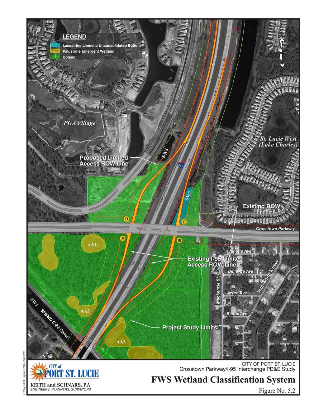
22
23 CROSSTOWN PARKWAY/I-95 INTERCHANGE PD&E STUDY ENDANGERED SPECIES BIOLOGICAL ASSESSMENT 5.2 SURFACE WATERS AND AQUATIC COMMUNITIES Three surface waters (SW) are located in the project area. The C-24 Canal (SW1) is located to the south of the proposed interchange. Two stormwater ponds, SW2 and SW3, are located in the northeast and northwest quadrants, respectively, of the proposed interchange. SW2 has steep rock-rubble banks and no littoral zone is present. The center of the pond has a colony of spatterdock (Nuphar lutea) and the pond edges have patches of maidencane and Peruvian primrose willow (Ludwigia peruviana). SW3 was recently constructed as part of the Montage Reserve development. The total area of each of the surface waters is 3.3 acres for SW2 and 1.5 acres for SW3. Calculating the total surface area of the C-24 Canal (SW1) is not feasible. Runoff from I-95 currently drains to SW2, which is also connected to the St. Lucie West development lake system via existing swales that drain to the north. This section was prepared in accordance with FDOT s PD&E Manual Part 2, Chapter 18 (4/14/99). The locations of surface waters are shown on Figures 5.1 and TERRESTRIAL HABITATS Most of the lands in the northern half of the project area are highly disturbed, as shown in Figure 5.1. The northwest quadrant is under development for residential land uses. Much of the upland habitat in the southern quadrants can be described as Scrubby Flatwoods. The southeast quadrant serves as upland mitigation lands for the City. The ROW required for the I-95 northbound ramp will require mitigation as outlined in the letter, dated September 9, 2005, from the City of Port St. Lucie, Director of Planning and Zoning, provided in Appendix A. The three wetlands described above are contained within the flatwoods habitats. The flatwoods have an open canopy consisting primarily of slash pines with a dense understory of gallberry (Ilex glabra), saw palmetto, wax myrtle, fetterbush (Lyonnia lucida), and rusty staggerbush (Lyonia ferruginea). The dense understory suggests this habitat is fire suppressed. The flatwoods east of I-95 have been impacted by all-terrain vehicles that have created a maze of trails within the forest. The areas adjacent to the C-24 Canal and along the western side of the I-95 ROW are dominated by nearly monotypic stands of dense Brazilian pepper. 6.0 LISTED SPECIES The state listed plant and animal species are maintained by the Florida Fish and Wildlife Conservation Commission (FFWCC) and are categorized as endangered, threatened, and species of special concern. They constitute Rules , and , Florida Administrative Code (FAC). The state lists of plants are categorized into endangered, threatened and commercially exploited, and are administered and maintained by the Florida Department of Agriculture and Consumer Services (FDACS) via Chapter 5B-40, FAC. The federal lists of animals and plants are administered by the FWS and categorized into endangered and threatened, and are published in 50 Code of Federal Regulations (CFR) (fauna) and 50 CFR (flora). On March 29, 2005, the Advance Notification (AN) for the project was distributed to the FWS, the FFWCC, and other governmental agencies. According to the FWS response letter, dated April 21, 2005, there are no recorded occurrences of listed threatened or endangered species within the project area (see Appendix A). In addition to providing the listed species, Table 6.1 also includes those species that could occur in the project area due to the presence of habitats that could potentially support them. The following sections discuss the species listed. Keith and Schnars P.A. 17
24 CROSSTOWN PARKWAY/I-95 INTERCHANGE PD&E STUDY ENDANGERED SPECIES BIOLOGICAL ASSESSMENT TABLE 6.1 LISTED SPECIES RECORDED IN ST. LUCIE COUNTY Scientific Name Common Name Agency Classification Plants Asimina tetramera Four-petal pawpaw FFWCC/FWS E Cladonia perforata Perforated reindeer moss FFWCC/FWS E Conradina grandiflora Large-flowered false rosemary FFWCC E Dicerandra immaculata Lakela s mint FFWCC/FWS E Encyclia tampensis Florida butterfly orchid FFWCC C Lechea cernua Nodding pinweed FFWCC T Ophioglossum palmatum Hand fern FFWCC E Opuntia stricta Erect prickly pear FFWCC T Osmunda cinnamonea Cinnamon fern FFWCC C Osmunda regalis Royal fern FFWCC C Polygala smallii Tiny polygala FFWCC/FWS E Tillandsia balbisiana Inflated wild pine FFWCC T Tillandsia fasciculata Common wild pine FFWCC E Tillandsia flexuosa Twisted airplant FFWCC E Tillandsia uticulata Giant airplant FFWCC E Amphibians Rana capito Gopher frog FFWCC SSC Reptiles Alligator mississippiensis American alligator FFWCC/FWS SSC (state) SA federall) Drymarchon corais couperi Eastern indigo snake FFWCC/FWS T Gopherus polyphemus Gopher tortoise FFWCC SSC Pituophis melanoleucus mugitis Florida pine snake FFWCC SSC Birds Aphelocoma coerulescens Florida scrub jay FFWCC/FWS T Egretta caerulea Little blue heron FFWCC SSC Egretta thula Snowy egret FFWCC SSC Egretta tricolor Tricolored heron FFWCC SSC Eudocimus albus White Ibis FFWCC SSC Falco peregrinus tundrius Arctic peregrine falcon FFWCC E (federal delisted) Falco sparverius paulus Southeastern American kestrel FFWCC T Haliaeetus lecocephalus Bald eagle FFWCC/FWS T Mycteria americana Wood stork FFWCC/FWS E Pandion haliaetus Osprey FFWCC SSC (Monroe Co. Only) Picoides borealis Red-cockaded woodpecker FFWCC/FWS E (federal) T (state) Polyborus plancus audubonii Audubon s crested caracara FFWCC/FWS T Rostrhamus sociabilis plumbeus Everglades snail kite FFWCC/FWS E Mammals Sciurus niger shermanii Sherman s fox squirrel FFWCC SSC Podomys floridanus Florida mouse FFWCC SSC (T) = threatened, (E) = endangered, (SA) = similarity of appearance, (C) = commercially exploited (SSC) = species of special concern, FFWCC = Florida Fish and Wildlife Conservation Commission FWS = U.S. Fish and Wildlife Service Keith and Schnars P.A. 18
25 CROSSTOWN PARKWAY/I-95 INTERCHANGE PD&E STUDY ENDANGERED SPECIES BIOLOGICAL ASSESSMENT 6.1 LISTED PLANTS Most of the listed plant species in St. Lucie County are found in open scrub habitats with open sandy areas, maintained by fire or fire-mimicking practices. No listed plants were observed in the project area, although it is possible that some of them could be present in the seed banks and could occur if these management practices could resume Lakela s Mint (Dicerandra immaculata) Lakela s mint is listed by the FWS and the FFWCC as an endangered species. It is a low-growing shrub found in light shade in scrub habitats along the Atlantic Coastal Ridge. It occupies sites with varying degrees of litter, from partly covered to bare sand. It is a gap species, thriving in open sunlight and becomes weakened as woody plants and saw palmetto invade open areas. It is endangered because of its extremely small range and levels of habitat destruction. Prescribed burning or equivalent management is recommended to maintain the quality of its habitat. However, little is known of its long-term requirements (FWS 1999). This species could occur in the project area although open gaps are scarce due to fire suppression. No Lakela s mint plants were observed during site investigations. The proposed project will have no effect on Lakela s mint Tiny Polygala (Polygala smallii) The tiny polygala is listed by the FWS and the FFWCC as an endangered species. It is a small rosetteforming species, known only from sand pockets of open pine rocklands, sand pine scrub, high pine, and open coastal spoil. The common characteristic of these habitats is that they are extremely dry and prone to periodic fires. Within these habitats, it requires high light levels and open sand with little to no organic litter accumulation. Reproduction from a seed bank appears to be important (FWS 1999). Populations are threatened because of fire suppression and exotic plant invasion. Suitable habitat is not present in the project area and this species was not observed during the site investigations. The proposed project will have no effect on the tiny polygala Four-petal Pawpaw (Asimina tetramera) The four-petal pawpaw is listed by the FWS and the FFWCC as an endangered species. It is found only in sand pine scrub in old, coastal dunes, ranging from open to mature canopy. It is adapted to periodic fires. It is endangered due to habitat destruction and fragmentation (FWS 1999). Sand pine scrub is not present in the project area and this species was not observed during the site investigations. The proposed project will have no effect on the four-petal pawpaw Large-flowered False Rosemary (Conradina grandiflora) The large-flowered false rosemary is listed by the FFWCC as an endangered species. It is endemic to the southeastern part of peninsular Florida and it occurs in sandy, upland habitats, especially in sand pine scrub (Austin et al. 1993). It is associated with sand pines and scrub oaks. Suitable habitat does not appear to be habitat in the project area and this species was not observed during the site investigations. The proposed project will have no effect on the large-flowered false rosemary. Keith and Schnars P.A. 19
26 CROSSTOWN PARKWAY/I-95 INTERCHANGE PD&E STUDY ENDANGERED SPECIES BIOLOGICAL ASSESSMENT Airplants (Tillandsia spp.) All of Florida's native species of bromeliads are epiphytic 1, although some species may sometimes be found growing terrestrially (Tillandsia utriculata and Tillandsia fasciculata). They are on the State's list of threatened and endangered species because of habitat destruction, collecting, and recently, due to the attack by the Mexican bromeliad weevil (Metamasius callizona). Airplants were observed in a live oak hammock outside the project area. The proposed project will have no effect on any species of airplants Perforated Reindeer Moss (Cladonia perforata) The perforated reindeer moss is listed by the FWS and the FFWCC as endangered species. It is restriced to high, well-drained white sand scrub communities, usually found on the Atlantic Coastal Ridge or the Lake Wales Ridge. It typically occurs in open patches between shrubs in areas of sparse or no herbaceous cover. This type of habitat is not present in the project area and this species was not observed during the site investigations. The proposed project will have no effect on the perforated reindeer moss Florida Butterfly Orchid (Encyclia tampensis) The Florida butterfly orchid is a fairly common orchid but it is listed by the FFWCC as a commercially exploited species. It is an epiphytic species that is found on several tree and palm species in forests and hammocks. It was not observed in the project area during the site investigations. The proposed project will have no effect on this species Nodding Pinweed (Lechea cernua) The nodding pinweed is listed by the FFWCC as a threatened species. It is found on bare, well-drained soils of white sand communities. This type of habitat is not present in the project area and this species was not observed during the site investigations. The proposed project will have no effect on the nodding pinweed Hand Fern (Ophioglossum palmatum) The hand fern is listed by the FFWCC as an endangered species. It is a small evergreen fern that inhabits old leaf bases of cabbage palms (Sabal palmetto) found in maritime or wet hammocks. This type of habitat is not found in the project area and it was not observed during the site investigations. The proposed project will have no effect on the hand fern Erect Prickly Pear (Opuntia stricta) The erect prickly pear is listed by the FFWCC as a threatened species. It is an erect or sprawling cactus that is found on calcareous shell mounds, dunes and coastal hammocks. This habitat is not found in the project area and this species was not observed during the site investigations. The proposed project will have no effect on the erect prickly pear. 2 Epiphyte a plant that lives independently but depends only on the physical support of another living plant Keith and Schnars P.A. 20
27 CROSSTOWN PARKWAY/I-95 INTERCHANGE PD&E STUDY ENDANGERED SPECIES BIOLOGICAL ASSESSMENT Cinnamon Fern (Osmunda cinnomonea) and Royal Fern (Osmunda regalis) The cinnamon and royal ferns are listed by the FFWCC as commercially exploited species. They are large, erect ferns that are usually found in partially shaded forested wetlands that have inundated or saturated soils throughout most of the year. Although the depression wetlands are located partially within the project area, they do not provide the suitable shaded habitat. Neither species was observed during the site investigations. The proposed project will have no effect on these fern species. 6.2 LISTED ANIMALS Gopher Tortoise (Gopherus polyphemus) Gopher tortoises are listed by the FFWCC as a Species of Special Concern (SSC) (this species is not listed by the FWS). Several commensal species that use gopher tortoise burrows are also listed, including the gopher frog (Rana capito), Florida pine snake (Pituophis melanoleucus mugitis), Florida mouse (Podomys floridanus), and the eastern indigo snake (Drymarchon corais couperi). The preferred habitat of the gopher tortoise and its commensal species is predominantly dry land-cover types, including sandhill, oak scrub and sand pine scrub. Suitable gopher tortoise habitat does not appear to be present within the proposed rightof-way. No gopher tortoises or their burrows were observed in the project area during the three site investigations over a three-year period although it is possible that they may be present in the dense undergrowth. The proposed project limits are included in the City s permit application to the FFWCC for all impacts to this species along the Crosstown Parkway corridor. This permit will ensure that the proposed project may affect, but is not likely to adversely affect the gopher tortoise Eastern Indigo Snake (Drymarchon corais couperi) The Eastern indigo snake is a large, black non-venomous snake found in sandhill habitats of Florida. It is listed by the FWS and FFWCC as a threatened species due to over-collecting and habitat loss and fragmentation. The species needs a mosaic of habitats to complete their annual cycle. In dry habitats, it is closely associated with the gopher tortoise and its burrows that provide shelter from winter cold and from desiccation. In the warmer climate of South Florida, it can be found in a wider range of habitats, such as hollow logs or the burrows of other animals, although they are uncommon in and near high-density human developments (FWS 1999). The probability of occurrence for this species is low due to the overgrown nature of the scrubby flatwoods. However, to assure the protection of this species during construction, The City will require that Standard Protection Measures for the Eastern Indigo Snake are followed. These protection guidelines will be implemented during construction. Thus, the proposed project may affect, but is not likely to adversely affect the eastern indigo snake Gopher Frog (Rana capito) Gopher frogs are listed by the State as a SSC and inhabit dry, sandy uplands, typically sandhill and scrub habitats. Nearby isolated wetlands or ponds are required for reproduction. They are nocturnal, spending daytimes hidden in shallow depressions or in the burrows of pocket gophers or gopher tortoises (Hipes et al. 2001). There is a low probability that this species is present in the project area. It is anticipated that the proposed project may affect, but is not likely to adversely affect the gopher frog. Keith and Schnars P.A. 21
28 CROSSTOWN PARKWAY/I-95 INTERCHANGE PD&E STUDY ENDANGERED SPECIES BIOLOGICAL ASSESSMENT Florida Pine Snake (Pituophis melanoleucus mugitis) The Florida pine snake is listed by the State as a SSC and inhabit areas with open canopies and dry sandy soils of sandhills, pine scrub, scrubby flatwoods, and old fields. Its pointed conical head is well adapted to burrowing. It often co-exists in the burrows of pocket gophers or gopher tortoises. Most of its time is spent below ground with occasional surface activity in the spring and fall. It has become rare due to collecting and habitat loss (Hipes et al. 2001). There is a low probability that this species is present in the project area. The proposed project may affect, but is not likely to adversely affect the Florida pine snake Florida Mouse (Podomys floridanus) The Florida mouse is listed as a SSC in Florida. It is found in dry upland communities, such as scrub, sandhill, and dry fields where they inhabit gopher tortoise burrows. When gopher tortoises are absent, they will dig their own burrows or use the burrows of other oldfield mice. There is a low probability that this species is present in the project area. The proposed project may affect, but is not likely to adversely affect the Florida mouse American Alligator (Alligator mississippiensis) The alligator is listed by the FWS as Threatened by Similarity of Appearance (to the endangered American Crocodile) and as a SSC by the FFWCC. It is likely that the alligator would be found in the C-24 Canal and it is possible that it could occasionally inhabit the depression wetlands. However, because of the minimal impacts to these habitats, the proposed project may affect, but is not likely to adversely affect the American alligator Florida Scrub Jay (Aphelocoma coerulescens) The preferred habitat of the scrub jay is predominantly oak scrub, sand pine scrub and dry prairie. The presence of scrub oaks is usually the key indicator of scrub habitat. The Florida scrub jay is listed by the FFWCC and the FWS as a threatened species. Scrub jays have not been documented within or near the project area and none were observed during the site investigations. The proposed project will have no effect on this species Red-cockaded Woodpecker (Picoides borealis) The red-cockaded woodpecker is listed by the FFWCC as a threatened species and by the FWS as an endangered species. The preferred habitat for this species is pine-dominated or pine/hardwood stands with a low or sparse understory and ample old-growth pines for nesting cavities and roosting. Suitable habitat for this species is not present in the project so that the proposed project will have no effect on this species Herons Wading birds, including the little blue heron (Egretta caerulea), reddish egret (Egretta rufescens), snowy egret (Egretta thula), tricolored heron (Egretta tricolor) and white ibis (Eudocimus albus) are listed by the FFWCC as SSC. These wading birds are not listed by the FWS. The preferred habitat of wading birds is predominantly forested wetlands and marshes. The depression marshes would likely be used by these Keith and Schnars P.A. 22
29 CROSSTOWN PARKWAY/I-95 INTERCHANGE PD&E STUDY ENDANGERED SPECIES BIOLOGICAL ASSESSMENT species although no evidence of nesting by these species was observed. None of these species were observed during the field investigations. Because of the minimal impacts to these habitats, the proposed project may affect, but is not likely to adversely affect these wading bird species Wood Stork (Mycteria americana) The wood stork is listed by the FFWCC and the FWS as an endangered species. The preferred habitat of the wood stork is similar to that of wading birds; however, the wood stork requires shallow water (about 12 inches in depth) with slow flowing conditions to feed. The project is located within the geographic range of and in the core foraging area of three active nesting colonies (Appendix A). At the time the field surveys were conducted, wood storks were not observed in the project area. In addition, the three wetlands do not have suitable foraging habitat for the wood stork. Impacts to the three wetlands are minimal so that the proposed project may affect, but is not likely to adversely affect the wood stork Bald Eagle (Haliaeetus lecocephalus) The bald eagle is currently listed by the FWS and FFWCC as a threatened species, although it is under consideration to become de-listed. It is a water-dependent species and is found near bodies of water. The C-24 Canal may be used for foraging but no eagle s nests (active or inactive) have been observed or recorded in the project area. The project does not fall within the primary or secondary zones of an active or inactive nest. The proposed project will have no effect on the bald eagle Osprey (Pandion haliaetus) The osprey is listed by the FFWCC as a species of special concern in Monroe County only; it is not listed outside of this county. Like bald eagles, they are water dependent for foraging and for feeding their young. Suitable habitat for osprey is not present in or near the project area. The proposed project will have no effect on osprey Audubon s Crested Caracara (Polyborus plancus audobonii) The Audubon s crested caracara is currently listed by the FWS and FFWCC as a threatened species. It is commonly found in dry or wet prairie (including improved pastures) with scattered cabbage palms or in lightly wooded areas (FWS 1999). Suitable habitat is not present in or near the project area. The proposed project will have no effect on the Audubon s crested caracara Arctic Peregrine Falcon (Falco peregrinus tundrius) The Arctic peregrine falcon is listed by FFWCC as endangered although it has been federally de-listed. The Arctic peregrine falcon breeds on the Arctic tundra. In winter, it migrates to and inhabits coastlines and mountains from Florida to South America. Thus, it is possible that the species may feed and roost in the project area but it is unlikely to inhabit the project area. None were observed during the site investigations and none have been reported. The proposed project will have no effect on this species Southeastern American Kestrel (Falco sparverius paulus) The Southeastern American kestrel is a small falcon that migrates to Florida during the winter months. It is listed by the FFWCC as a threatened species due to habitat loss and lack of suitable nesting sites. It nests Keith and Schnars P.A. 23
30 CROSSTOWN PARKWAY/I-95 INTERCHANGE PD&E STUDY ENDANGERED SPECIES BIOLOGICAL ASSESSMENT in cavities in dead trees, particularly long leaf or slash pines with an open, short understory to be able to see and catch their prey. The scrubby flatwoods in the project area do not appear to offer suitable habitat for this species and it is unlikely to inhabit the project area. The proposed project will have no effect on this species Everglades Snail Kite (Rostrhamus sociabilis plumbeus) The Everglades snail kite is a medium-sized raptor that feeds almost exclusively on apple snails. Thus, the species is highly dependent on the hydrology and water quality of freshwater emergent, long-hydroperiod marshes and shallow areas of freshwater lakes in which the snail can be found. Preferred habitat includes a mosaic of open water and emergent vegetation. The species has been reported in the Savannas Preserve State Park to the east of the project area (FWS 1999). Although it is possible that the species occurs in the small freshwater marshes located within the project area, these habitats do not exhibit the suitable characteristics for the occurrence of apple snails. This it is not likely the snail kite inhabits the project area. The proposed project will have no effect on the Everglades snail kite Sherman s Fox Squirrel (Sciurus niger shermanii) Sherman s fox squirrel is listed by the FFWCC as a SSC. It inhabits sandhills (high pine), pine flatwoods, pastures and other open, weedy habitats with scattered pines and oaks. It depends on a variety of oak trees for seasonal food and nest material. It usually nests in oak trees and nests are constructed of oak leaves and Spanish moss. This type of habitat is present only in the small oak hammock that will not be affected by the proposed project. The proposed project will have no effect on Sherman s fox squirrel. 7.0 IMPACT ANALYSIS Fifteen plant and eighteen animal species protected by the FWS, FFWCC, or the FDACS were determined to potentially occur within the project area. No State or Federal listed plant species were observed and the specialized habitat that would support the listed plants was not present in the project area. The proposed project would have no effect on any listed plant species. No State or Federal listed wildlife species were observed during field investigations although the exotic dominated scrubby flatwoods and the depression wetlands could potentially provide habitat for several listed wildlife species. These included the gopher tortoise, eastern indigo snake, gopher frog, Florida pine snake, Florida mouse, American alligator, little blue heron, reddish egret, snowy egret, tricolored heron, white ibis and wood stork. The project area is within the core foraging area of documented nesting colonies of wood storks. The C-24 Canal and the freshwater wetlands may provide foraging or resting habitat for wading birds and wood storks. The habitat provided by the C-24 Canal would not be affected by the construction of the interchange. The wetlands would be minimally affected. The proposed project may affect, but is not likely to adversely affect these State and Federal listed animal species. Therefore, the proposed project is consistent with the Endangered Species Act. Keith and Schnars P.A. 24
31 CROSSTOWN PARKWAY/I-95 INTERCHANGE PD&E STUDY ENDANGERED SPECIES BIOLOGICAL ASSESSMENT 8.0 COORDINATION Pre-application meetings were held with the SFWMD on June 27, 2005, and October 18, 2005, to discuss drainage, environmental, and wetlands issues. In response to the AN, only the FWS commented on listed species in the vicinity of the project (Appendix A). 9.0 BIBLIOGRAPHY Austin, D., P. Honychurch, and S. Bass. Scrub Plant Guide. Gumbo Limbo Nature Center of South Palm Beach County, Florida, Chafin, L.G. Field guide to the rare plants of Florida. Florida Natural Areas Inventory. Tallahassee, Florida, Cowardin, L. M., V. Carter, F.C. Golet, and E.T. LaRoe. Classification of wetlands and deepwater habitats of the United States. FWS. Washington, D.C., Hipes, D., D. R. Jackson, K. NeSmith, D. Printiss, and K. Brandt. Field guide to the rare animals of Florida. Florida Natural Areas Inventory. Tallahassee, Florida, 2001 Florida Department of Agriculture and Consumer Services, Division of Plant Industry. Notes on Florida s Endangered and Threatened Plants, 1998 Florida Fish and Wildlife Conservation Commission. Closing the Gaps in Florida s Wildlife Habitat Conservation System, Florida Natural Areas Inventory and Florida Department of Natural Resources. Guide to the Natural Communities of Florida, Fitzpatrick, J.W., G.E. Woolfenden, and M.T. Kopeny. Ecology and development-related habitat requirements of the Florida scrub-jay (Amhelocoma coerulescens). Florida Game and Freshwater Fish Commission, Nongame Wildlife Program Technical Report No. 8. Tallahassee, FL., U.S. Fish and Wildlife Service. South Florida Multi-species Recovery Plan. U.S. Fish and Wildlife Service, Southeast Region. Atlanta Georgia, Wunderlin, R.P. and B.F. Hansen. Guide to the vascular plants of Florida. 2 nd ed. University Press of Florida, Gainesville, Florida, Keith and Schnars P.A. 25
32 APPENDIX A COORDINATION
33 April 2 1,2005 Walter England City of Port St. Lucie 121 SW Port St. Lucie Boulevard Port St. Lucie, Florida Service Log No.: PL Date Received: April 12,2005 Project: Interstate 95 Interchange at West Virginia Drive County: St. Lucie Dear Mr. England: Thank you for your letter dated March 29,2005, in which you requested the Fish and Wildlife Service s (Service) technical assistance for the project referenced above. PROJECT DESCRIPTION The project consists of constructing a new interchange to Interstate 95 at West Virginia Drive. The purpose of the project is to meet traffic demands due to tlie ongoing growth and development in the region. The project is located in St. Lucie County, Florida. THREATENED AND ENDANGERED SPECIES The Service has reviewed its Geographic Information System (GIS) database for recorded locatioiis of federally listed threatened and endangered species on or adjacent to your project. The GIS database is a coinpilation of data received from several sources. Wood stork The project occurs within the geographic range of the endangered wood stork (Mycterin nnzericnna). We have identified three active wood stork nesting colonies located near the project area. The project is located in the core foraging area (CFA) (within 18.6 miles) of these nesting colonies. These colonies are located approximately 6.2 miles and 15.6 miles southeast and 12.9 miles west of the project corridor. The Service believes tlie loss of wetlands within a CFA due to an action could result in tlie loss of foraging habitat for the wood stork. To minimize adverse effects to the wood stork, we recommend any lost foraging habitat resulting from the project be replaced within the CFA of the affected nesting colony. Moreover, wetlands provided
Preliminary Environmental Site Assessment Report
 Science Working For You Preliminary Environmental Site Assessment Report Wetland and Wildlife Survey Volusia County Parcel 06-19-32-00-00-0030 Prepared for: Orange Blossom Trail Orlando LLC 8650-12 Old
Draft Biological Assessment Report Design Update Technical Memorandum I-75 (SR 93) at SR 884 (Colonial Blvd) Interchange Lee County, Florida
 at SR 884 (Colonial Blvd) Interchange Lee County, Florida") Draft Biological Assessment Report Design Update I-75 (SR 93) at SR 884 (Colonial Blvd) Interchange Lee County, Florida Financial Project ID No. 413065-1-32-01 Prepared for: Florida Department of Transportation
Draft Biological Assessment Report Design Update I-75 (SR 93) at SR 884 (Colonial Blvd) Interchange Lee County, Florida Financial Project ID No. 413065-1-32-01 Prepared for: Florida Department of Transportation
M E M O R A N D U M. Dianne Rosensweig, Scheda Ecological Associates, Inc. Environmental Assessment and Jurisdictional Determination
 M E M O R A N D U M TO: FROM: RE: Stephen Suau, P.E. Dianne Rosensweig, Scheda Ecological Associates, Inc. Environmental Assessment and Jurisdictional Determination Palmer Ranch Proposed Infill Project
Picayune Strand Restoration Project in Southwest Florida A Landscape Perspective
 U.S. Fish and Wildlife Service Restoring America s Everglades-Recovering Multiple Species Picayune Strand Restoration Project in Southwest Florida A Landscape Perspective Kim Dryden U.S. Fish and Wildlife
December 16, Florida Fish and Wildlife Conservation Commission. Re:
 December 16, 20 15 Florida Fish and Wildlife Conservation Commission Tracy Hurst Tampa Permits Section U.S. Army Corps of Engineers 10117 Princess Palm Avenue, Suite 120 Tampa, FL 33610 Tracy.E.Hurst@usace.anny.mil
PUBLIC NOTICE. Permit Application No. SAJ (IP-MJD)
") DEPARTMENT OF THE ARMY JACKSONVILLE DISTRICT CORPS OF ENGINEERS FORT MYERS REGULATORY OFFICE 1520 ROYAL PALM SQUARE BOULEVARD, SUITE 310 FORT MYERS, FLORIDA 33919 Regulatory Division South Permits Branch/West
DEPARTMENT OF THE ARMY JACKSONVILLE DISTRICT CORPS OF ENGINEERS FORT MYERS REGULATORY OFFICE 1520 ROYAL PALM SQUARE BOULEVARD, SUITE 310 FORT MYERS, FLORIDA 33919 Regulatory Division South Permits Branch/West
Jackson Bottom Wetlands Preserve BCS Number: 47-14
 Jackson Bottom Wetlands Preserve BCS Number: 47-14 Site description author(s) Greg Gillson, Jackson Bottom Wetlands Preserve Primary contact for this site Ed Becker, Natural Resources Manager, Jackson
Environmental Assessment Report. Siena Lakes PUD (aka: LCS Naples CCRC PUD)
") Environmental Assessment Report of Siena Lakes PUD (aka: LCS Naples CCRC PUD) 29.25 acre Parcel Sec. 01, T49S, R25E Orange Blossom Drive, Collier County, FL September 29, 2008 Revised: April 2, 2009 Updated:
Environmental Assessment Report of Siena Lakes PUD (aka: LCS Naples CCRC PUD) 29.25 acre Parcel Sec. 01, T49S, R25E Orange Blossom Drive, Collier County, FL September 29, 2008 Revised: April 2, 2009 Updated:
BV-24A DMMA Florida Scrub-Jay Survey Brevard County
 REPORT BV-24A DMMA Florida Scrub-Jay Survey Brevard County Submitted to: David L. Stites, Ph.D. Director of Environmental Services Taylor Engineering, Inc. 10199 Southside Blvd Suite 310 Jacksonville,
SEBASTIAN AREA-WIDE SCRUB-JAY HABITAT CONSERVATION PLAN & Public Use Improvements
 SEBASTIAN AREA-WIDE SCRUB-JAY HABITAT CONSERVATION PLAN & Public Use Improvements Beth Powell Conservation Lands Manager Parks Division Indian River County Description of the HCP Allows for Incidental
2012 Wading Bird Nesting in the Everglades
 Wading Bird Nesting in the Everglades Large scale Restoration Needed to Recover Wading Bird Populations Introduction The annual South Florida Wading Bird Report 1 provides an overview of wading bird nesting
Louisiana quillwort Current Federal Status: Endangered throughout its range.
 Threatened & Endangered Species Report for the Plains Southcap, LLC 41-mile-long Ten-Mile Facility to Chevron Pascagoula Refinery Project Determination of Impact: The Escatawpa River, will be crossed via
Arendt, R. (1994). Rural by Design: Maintaining Small Town Character. Chicago, IL: American Planning Association.
. Rural by Design: Maintaining Small Town Character. Chicago, IL: American Planning Association.") Bald Eagle Management Plan FWC 2008. Bald Eagle Management Plan (Haliaeetus leucocephalus). Florida Fish and Wildlife Conservation Commission. Tallahassee, April 9. Buffer slopes Castelle, A.J., A.W. Johnson
Bald Eagle Management Plan FWC 2008. Bald Eagle Management Plan (Haliaeetus leucocephalus). Florida Fish and Wildlife Conservation Commission. Tallahassee, April 9. Buffer slopes Castelle, A.J., A.W. Johnson
DEPARTMENT OF THE ARMY JACKSONVILLE DISTRICT CORPS OF ENGINEERS PRINCESS PALM AVENUE, SUITE 120 TAMPA, FLORIDA
 DEPARTMENT OF THE ARMY JACKSONVILLE DISTRICT CORPS OF ENGINEERS 10117 PRINCESS PALM AVENUE, SUITE 120 TAMPA, FLORIDA 33610 REPLY TO ATTENTION OF October 12, 2012 Tampa Permits Section SAJ-2011-00551 (IP-TEH)
FWC and Florida s Imperiled Species Management Laura DiGruttolo Florida Fish and Wildlife Conservation Commission Division of Habitat and Species
 FWC and Florida s Imperiled Species Management Laura DiGruttolo Florida Fish and Wildlife Conservation Commission Division of Habitat and Species Conservation Imperiled Species Management Goal With broad
Marine Corps Support Facility-Blount Island: Integrated Natural Resources Program Successes. E2S2 Conference May 12, 2011
 Marine Corps Support Facility-Blount Island: Integrated Natural Resources Program Successes E2S2 Conference May 12, 2011 Shari Kennedy, MCSF-BI Robert Price, CH2M HILL Location Mission The mission of Marine
Tiered Species Habitats (Terrestrial and Aquatic)
") Tiered Species Habitats (Terrestrial and Aquatic) Dataset Description Free-Bridge Area Map The Department of Game and Inland Fisheries (DGIF s) Tiered Species Habitat data shows the number of Tier 1, 2
Tiered Species Habitats (Terrestrial and Aquatic) Dataset Description Free-Bridge Area Map The Department of Game and Inland Fisheries (DGIF s) Tiered Species Habitat data shows the number of Tier 1, 2
Habitat Use by Wildlife in Agricultural and Ranching Areas in the Pantanal and Everglades. Dr. Júlio Cesar de Souza and Dr. Elise V.
 Habitat Use by Wildlife in Agricultural and Ranching Areas in the Pantanal and Everglades Dr. Júlio Cesar de Souza and Dr. Elise V. Pearlstine Pantanal 140,000 km 2 of wetlands with a monomodal flood pulse
PRELIMINARY ECOLOGICAL ASSESSMENT REPORT Lake Hamilton Parcels: Polk County, Florida
 PRELIMINARY ECOLOGICAL ASSESSMENT REPORT Lake Hamilton Parcels: 272817829501000010 272817829503000040 272817829503000030 Polk County, Florida PREPARED BY: INWOOD CONSULTING ENGINEERS, INC. 3000 Dovera
PART FIVE: Grassland and Field Habitat Management
 PART FIVE: Grassland and Field Habitat Management PAGE 64 15. GRASSLAND HABITAT MANAGEMENT Some of Vermont s most imperiled birds rely on the fields that many Vermonters manage as part of homes and farms.
Baskett Slough National Wildlife Refuge BCS number: 47-4
 Baskett Slough National Wildlife Refuge BCS number: 47-4 Site description author(s) Daphne E. Swope, Research and Monitoring Team, Klamath Bird Observatory Primary contact for this site N/A Location (UTM)
Bald Eagle Annual Report February 1, 2016
 Bald Eagle Annual Report 2015 February 1, 2016 This page intentionally blank. PROJECT SUMMARY Project Title: Bald Eagle HCP Monitoring Subject Area: Habitat Conservation Plan (HCP) monitoring Date initiated:
DEPARTMENT OF THE ARMY JACKSONVILLE DISTRICT CORPS OF ENGINEERS PRINCESS PALM AVENUE, SUITE 120 TAMPA, FLORIDA
 DEPARTMENT OF THE ARMY JACKSONVILLE DISTRICT CORPS OF ENGINEERS 1117 PRINCESS PALM AVENUE, SUITE 12 TAMPA, FLORIDA 3361 REPLY TO ATTENTION OF July 3, 212 Tampa Permits Section SAJ-211-551 (IP-TEH) Ms.
Wulfert Bayous Land Acquisition Campaign. Preserve. Protect. Inspire. Ding Darling Wildlife Society
 Wulfert Bayous Land Acquisition Campaign Preserve. Protect. Inspire. Ding Darling Wildlife Society Project Overview Wulfert Bayous is the largest unprotected property on Sanibel Island, and is adjacent
18. Endangered Species
 Northern Branch Corridor SDEIS March 207 8. Endangered Species 8.. Chapter Overview 8... Introduction This chapter discusses the changes to the potential for project improvements to adversely affect threatened
Florida Keys National Wildlife Refuge Complex. Key West NWR Great White Heron NWR National Key Deer NWR Crocodile Lake NWR
 Florida Keys National Wildlife Refuge Complex Key West NWR Great White Heron NWR National Key Deer NWR Crocodile Lake NWR Key West NWR Marquesas Keys and 13 other keys Mission as a preserve and protect
RECENT CHANGES TO THE ILLINOIS SMCRA THREATENED AND ENDANGERED SPECIES (T&E) REQUIREMENTS
 REQUIREMENTS") RECENT CHANGES TO THE ILLINOIS SMCRA THREATENED AND ENDANGERED SPECIES (T&E) REQUIREMENTS William O Leary, M.S. and Amanda Pankau, M.S. HDR Engineering Murphysboro, IL ILLINOIS SMCRA T&E HISTORY 1983 2009
RECENT CHANGES TO THE ILLINOIS SMCRA THREATENED AND ENDANGERED SPECIES (T&E) REQUIREMENTS William O Leary, M.S. and Amanda Pankau, M.S. HDR Engineering Murphysboro, IL ILLINOIS SMCRA T&E HISTORY 1983 2009
Key Findings of the 2017 South Florida Wading Bird Report
 The 2017 wading bird nesting season produced some of the highest nest counts in a decade, with a total of 46,248 nests which represents a moderate improvement from the 10-year annual average of 39,065
WATER BIRDS OF PALM BEACH COUNTY
 WATER BIRDS OF PALM BEACH COUNTY Presented by : The Audubon Society of the Everglades www.auduboneverglades.org Text and Photographs by Larry Hess Types of Water Birds Seen in Palm Beach County Ducks and
Mexican Spotted Owl Monitoring and Inventory from in the Lincoln National Forest, New Mexico
 Mexican Spotted Owl Monitoring and Inventory from 2001-2005 in the Lincoln National Forest, New Mexico Submitted to: Rene Guaderrama Lincoln National Forest Sacramento Ranger District P. O. Box 288 Cloudcroft,
1.0 Performance Measure Title Wetland Trophic Relationships Wading Bird Nesting Patterns. 2.0 Justification
 1.0 Performance Measure Title Wetland Trophic Relationships Wading Bird Nesting Patterns Last Date Revised: December 2006 2.0 Justification Over the past several decades, wading bird reproduction in the
Sauvie Island Wildlife Area BCS number: 47-28
 Sauvie Island Wildlife Area BCS number: 47-28 Site description author(s) Mark Nebeker, Oregon Department of Fish and Wildlife, Sauvie Island Wildlife Area Manager Primary contact for this site Mark Nebeker,
Division: Habitat and Species Conservation Authors: Claire Sunquist Blunden and Brad Gruver
 Division: Habitat and Species Conservation Authors: Claire Sunquist Blunden and Brad Gruver Report date: December 13, 2018 All photos by FWC unless otherwise acknowledged Presenting 6 new guidelines 1
Mud Slough Wetland Reserve BCS number: 47-19
 Mud Slough Wetland Reserve BCS number: 47-19 ***NOTE: We were unable to determine all necessary information for this site description. If you would like to contribute the needed information to this description,
Golden Eagle (Aquila chrysaetos) Management Indicator Species Assessment Ochoco National Forest
 Management Indicator Species Assessment Ochoco National Forest") Golden Eagle (Aquila chrysaetos) Management Indicator Species Assessment Ochoco National Forest I. Introduction The golden eagle was chosen as a terrestrial management indicator species (MIS) on the Ochoco
Golden Eagle (Aquila chrysaetos) Management Indicator Species Assessment Ochoco National Forest I. Introduction The golden eagle was chosen as a terrestrial management indicator species (MIS) on the Ochoco
McKay Creek National Wildlife Refuge BCS number: 48-19
 Oregon Coordinated Aquatic Bird Monitoring: Description of Important Aquatic Bird Site McKay Creek National Wildlife Refuge BCS number: 48-19 Site description author(s) Howard Browers, Supervisory Wildlife
Oregon Dunes National Recreation Area BCS Number: 47-5
 Oregon Dunes National Recreation Area BCS Number: 47-5 ***NOTE: We were unable to determine all necessary information for this site description. If you would like to contribute the needed information to
Mixed Conifer Working Group Meeting February 17, 2011 Wildlife Habitat Management Considerations
 Mixed Conifer Working Group Meeting February 17, 2011 Wildlife Habitat Management Considerations Overview 1. Existing mixed conifer habitat 2. Habitat trends 3. Factors influencing wildlife habitat suitability
Learning about Forests (LEAF) Ireland. What Habitat do I Live in?
 Ireland. What Habitat do I Live in?") Learning about Forests (LEAF) Ireland What Habitat do I Live in? Activity Instructions: Print each individual slide (Think Green! laminate if you wish to reuse them) 12 Species cards & 12 Habitat cards
Learning about Forests (LEAF) Ireland What Habitat do I Live in? Activity Instructions: Print each individual slide (Think Green! laminate if you wish to reuse them) 12 Species cards & 12 Habitat cards
SOUTHWEST FLORIDA LANDSCAPE CONSERVATION DESIGN Document Appendices
 SOUTHWEST FLORIDA LANDSCAPE CONSERVATION DESIGN Document Appendices 2017 Southwest Florida Landscape Conservation Design: Document Appendices December 2017 Prepared by: National Wildlife Refuge Association
Listed Birds along the Stony Brook Corridor Impacted by BMS Zoning Change
 Listed Birds along the Stony Brook Corridor Impacted by BMS Zoning Change Washington Crossing Audubon Society (WCAS) opposes the zoning change to allow high density housing on the Bristol-Meyers Squibb
U.S. Fish & Wildlife Service. My project. IPaC Trust Resource Report. Generated May 07, :40 AM MDT
 U.S. Fish & Wildlife Service My project Generated May 07, 2015 10:40 AM MDT US Fish & Wildlife Service Project Description NAME My project PROJECT CODE LOCATION Prince William County, Virginia No description
Upper Klamath National Wildlife Refuge Complex Upper Klamath Unit and Hank s Marsh Unit BCS Number: 48-29
 Oregon Coordinated Aquatic Bird Monitoring: Description of Important Aquatic Bird Site Upper Klamath National Wildlife Refuge Complex Upper Klamath Unit and Hank s Marsh Unit BCS Number: 48-29 Site description
Florida Birds East Coast
 Florida Birds East Coast The very best place to see and photograph birds and other wildlife during the frigid northern winter months is warm, sunny Florida. It s at this time of year that the flow of people
The Long Point Causeway: a history and future for reptiles. Scott Gillingwater
 The Long Point Causeway: a history and future for reptiles Scott Gillingwater Environmental Effects Long Point World Biosphere Reserve UNESCO designated the Long Point World Biosphere Reserve in April
WISCONSIN BIRD CONSERVATION INITIATIVE IMPORTANT BIRD AREAS PROGRAM
 WISCONSIN BIRD CONSERVATION INITIATIVE IMPORTANT BIRD AREAS PROGRAM NOMINATION FORM The Wisconsin Bird Conservation Initiative (WBCI) is conducting an inventory of areas that may qualify as Important Bird
Ladd Marsh Wildlife Area BCS number: 49-3
 Oregon Coordinated Aquatic Bird Monitoring: Description of Important Aquatic Bird Site Ladd Marsh Wildlife Area BCS number: 49-3 Site description author M. Cathy Nowak, Ladd Marsh Wildlife Area Biologist
Wanaket Wildlife Area BCS number: 48-30
 Oregon Coordinated Aquatic Bird Monitoring: Description of Important Aquatic Bird Site Wanaket Wildlife Area BCS number: 48-30 Site description author(s) M. Cathy Nowak, ODFW, Ladd Marsh Wildlife Area
Killin Wetland (Cedar Canyon Marsh) BCS number: 47-15
 BCS number: 47-15") Killin Wetland (Cedar Canyon Marsh) BCS number: 47-15 ***NOTE: We were unable to determine all necessary information for this site description. If you would like to contribute the needed information to
Killin Wetland (Cedar Canyon Marsh) BCS number: 47-15 ***NOTE: We were unable to determine all necessary information for this site description. If you would like to contribute the needed information to
Eastern Lake Ontario Dunes D-3 Assessment SLELO-PRISM Buckthorn and Swallow-wort Surveillance/Dune Willow Monitoring
 St. Lawrence Eastern Lake Ontario Partnership for Regional Invasive Species Management Eastern Lake Ontario Dunes D-3 Assessment Buckthorn and Swallow-wort Surveillance/Dune Willow Monitoring July 13 &
Buckner Preserve Shrubland Habitat Management Recommendations
 Buckner Preserve Shrubland Habitat Management Recommendations Margaret Fowle & Mark LaBarr Audubon Vermont 255 Sherman Hollow Rd Huntington, VT 05462 October 2015 Background Information The following pages
Riparian Raptors Potentially Impacted by USACE Reservoir Operations
 Riparian Raptors Potentially Impacted by USACE Reservoir Operations Osprey (Photo by Les Turner) Bald Eagle (Photo by Tom Barnes) Peregrine Falcon (Photo by Greg Gothard) Red-shouldered hawk (Photo by
King Mill Lambert DRI# 2035 Henry County, Georgia
 Transportation Analysis King Mill Lambert DRI# 2035 Henry County, Georgia Prepared for: The Alter Group, Ltd. Prepared by: Kimley-Horn and Associates, Inc. Norcross, GA Kimley-Horn and Associates, Inc.
Environmental Protection
 Myakka Wild and Scenic River Program 2017 Annual Report 1 A. Permitting & Regulatory issues 1. Construction continues at the bridge replacement at C.R. 780. MRP030314 was issued to Sarasota County on March
Instructions for Joining the Webinar.
 New Recovery Plan Review from the Gulf of Mexico Alliance Caroline Gorga, Wildlife Legacy Biologist, Florida Fish & Wildlife Conservation Commission Julia Lightner, Fisheries Biologist, Louisiana Department
Establishment of Additional Monarch Butterfly Host Plants at the Sand Hill Lakes Mitigation Bank
 Establishment of Additional Monarch Butterfly Host Plants at the Sand Hill Lakes Mitigation Bank David Clayton Environmental Scientist III David.Clayton@nwfwater.com Northwest Florida Water Management
Toronto s Urban Wilderness
 Tommy Thompson Park Toronto s Urban Wilderness Park History Early Construction Construction began in 1959 by Toronto Harbour Commissioners Expand port related facilities Dispose of rubble and fill from
Humboldt Bay NWR BCS number: 86-4
 Humboldt Bay NWR BCS number: 86-4 ***NOTE: We were unable to determine all necessary information for this site description. If you would like to contribute the needed information to this description, please
APPENDIX G. Biological Resources Reports
 APPENDIX G Biological Resources Reports November 9, 2009 David Geiser Merlone Geier Management, LLC 3580 Carmel Mountain Rd., Suite 260 San Diego, California 92130 RE: Neighborhood at Deer Creek, Petaluma,
Hardrock Project GRT Terrestrial Working Group Environmental Baseline
 Hardrock Project GRT Terrestrial Working Group Environmental Baseline February 24, 2015 : Presentation Overview Introductions Project Overview Terrestrial Objectives / methods Results / key takeaways Discussion
4-H Conservation Guidelines
 4-H Conservation Guidelines The following are guidelines for providing learning experiences in the conservation project area. THE GUIDELINES FOR ALL MEMBERS Understand what Natural Resources are; how to
Black-crowned Night-heron Minnesota Conservation Summary
 Credit Deborah Reynolds Black-crowned Night-heron Minnesota Conservation Summary Audubon Minnesota Spring 2014 The Blueprint for Minnesota Bird Conservation is a project of Audubon Minnesota written by
BALD EAGLE MANAGEMENT 2014 ANNUAL REPORT
 SETTLEMENT AGREEMENT ARTICLE 513 BALD EAGLE MANAGEMENT 2014 ANNUAL REPORT REPORTING PERIOD JANUARY 1 DECEMBER 31, 2014 BAKER RIVER HYDROELECTRIC PROJECT FERC No. 2150 September 2015 PUGET SOUND ENERGY
ASSESSING HABITAT QUALITY FOR PRIORITY WILDLIFE SPECIES IN COLORADO WETLANDS
 C O L O R A D O P A R K S Dabbling Ducks & W I L D L I F E GADWALL TOM KOERNER, USFWS / AMERICAN WIGEON BILL GRACEY NORTHERN PINTAIL GEORGIA HART / MALLARD MICHAEL MENEFEE, CNHP / ALL TEAL PHOTOS TOM KOERNER,
Northern Remnant of the. Everglades Ecosystem. Sylvia R. Pelizza
 Arthur R. Marshall Loxahatchee Nation nal Wildlife Refuge Northern Remnant of the Everglades Ecosystem Sylvia R. Pelizza Project tleader National Wildli fe Refuge System Administered i d by the U.S. Fish
Species Conclusions Table
 Species Conclusions Table Project Manager: Theresita Crockett-Augustine Date: May 9, 2016 Project Name: Huntington Run Levee Project Number: NAO-2014-00272 Consultation Code: 05E2VA00-2016-SLI-1964 Event
Pine Lake Preserve Land Management Plan
 Pine Lake Preserve Land Management Plan 2 nd Edition 12750 East Terry Street Bonita Springs, Florida 34135 Prepared by the Land Stewardship Section Lee County Department of Parks and Recreation Approved
Least Bell's Vireo & Western Burrowing Owl Surveys
 I - 15 CORRIDOR CAMPUS MASTER PLAN DRAFT EIR MT. SAN JACINTO COMMUNITY COLLEGE DISTRICT Appendices Appendix D5 Least Bell's Vireo & Western Burrowing Owl Surveys August 2017 I - 15 CORRIDOR CAMPUS MASTER
CORE *REQUIRED OF ALL COMMUNITIES* CIIY TOWN COUNIY YES YES YES YES YES
 CORE *REQUIRED OF ALL COMMUNITIES* ACTIVIIY COUNIY CIIY SEMI 1. Host a Community Wildlife Project Meeting 2. Add at least 4 books or videos dealing with wildlife or wildlife conservation to a school or
Erie County Van Trip. Pipe Creek Wildlife Area
 Erie County Van Trip ***See red markings on maps indicating the best birding options at each location. Please note that you are not limited to these areas, they are just the areas we feel will be most
Natural Heritage Inventory and Evaluation for the Medway Valley Heritage Forest South ESA. Public Meeting January 27, 2014
 Natural Heritage Inventory and Evaluation for the Medway Valley Heritage Forest South ESA Welcome! Tonight you will have the opportunity to learn and comment on: Purpose of the Inventory and Evaluation
Tualatin River NWR and Wapato Lake BCS number: 47-37
 Tualatin River NWR and Wapato Lake BCS number: 47-37 ***NOTE: We were unable to determine all necessary information for this site description. If you would like to contribute the needed information to
Threatened & Endangered Species and T&E Habitats Encountered during Road and Bridge Projects
 Threatened & Endangered Species and T&E Habitats Encountered during Road and Bridge Projects Keto Gyekis Wetland Identification Program (WIP) Coordinator T&E Species Technical Review Coordinator Project
Expansion Work Has Begun The perimeter dike for Cell 7 is now visible
 Summer/Fall 2017 In This Issue Poplar Island Expansion Wetland Cell 5AB Development Wildlife Update Birding tours on Poplar Island Expansion Work Has Begun The perimeter dike for Cell 7 is now visible
Alvord Lake BCS number: 48-2
 Oregon Coordinated Aquatic Bird Monitoring: Description of Important Aquatic Bird Site Alvord Lake BCS number: 48-2 Site description author(s) Whitney Haskell, Data Management Intern, Klamath Bird Observatory
Agency Approvals of Listed Species Survey Protocol Document
 Sabal Trail Project Sabal Trail Transmission, LLC Federal and State Species Specific Survey Report Alabama, Georgia, Florida APPENDIX C Agency Approvals of Listed Species Survey Protocol Document Sabal
Shrubland Bird Ecology & Management. What are shrublands?
 Shrubland Bird Ecology & Management Matt Tarr Associate Extension Professor Wildlife Specialist University of New Hampshire Cooperative Extension Shrublands are habitats: dominated by shrubs and young
APPENDIX A Vernal Field Office Best Management Practices for Raptors and Associated Habitats
 APPENDIX A Vernal Field Office Best Management Practices for Raptors and Associated Habitats A-1 A-2 APPENDIX A VERNAL FIELD OFFICE BEST MANAGEMENT PRACTICES FOR RAPTORS AND ASSOCIATED HABITATS September
Relicensing Study 3.5.1
 Relicensing Study 3.5.1 BASELINE INVENTORY OF WETLAND, RIPARIAN AND LITTORAL HABITAT IN THE TURNERS FALLS IMPOUNDMENT, AND ASSESSMENT OF OPERATIONAL IMPACTS ON SPECIAL-STATUS SPECIES Updated Study Report
Ferruginous Hawk Buteo regalis
 Photo by Teri Slatauski Habitat Use Profile Habitats Used in Nevada Sagebrush Pinyon-Juniper (Salt Desert Scrub) Key Habitat Parameters Plant Composition Sagebrush spp., juniper spp., upland grasses and
2011 Wood River Wetland Yellow Rail (Coturnicops neveboracensis noveboracensis) Survey Report
 Survey Report") 2011 Wood River Wetland Yellow Rail (Coturnicops neveboracensis noveboracensis) Survey Report Project Description The Bureau of Land Management s Wood River Wetland is located in T34S-R 7 1/2E; the wetland
2011 Wood River Wetland Yellow Rail (Coturnicops neveboracensis noveboracensis) Survey Report Project Description The Bureau of Land Management s Wood River Wetland is located in T34S-R 7 1/2E; the wetland
APPENDIX B NATURAL FEATURES INVENTORY
 APPENDIX B NATURAL FEATURES INVENTORY Environmental Existing Conditions The following sections provide a summary of the literature review and preliminary environmental overview of the existing natural
Grey County Natural Heritage System Study
 Grey County Natural Heritage System Study Green in Grey Technical Advisory Committee Meeting #1 February 25, 2015 225 Labrador Drive, Unit 1, Waterloo, Ontario, N2K 4M8 Tel: (519) 725-2227 Web: www.nrsi.on.ca
2017 Monarch Butterfly Conservation Fund Grant Slate
 2017 Monarch Butterfly Conservation Fund Grant Slate NFWF CONTACT Todd Hogrefe Director, Central Regional Office todd.hogrefe@nfwf.org 612-564-7286 PARTNERS Monarch butterflies ABOUT NFWF The National
Fernhill Wetlands BCS number: 47-13
 Fernhill Wetlands BCS number: 47-13 ***NOTE: We were unable to determine all necessary information for this site description. If you would like to contribute the needed information to this description,
Party With a Purpose: MARSTEL-DAY GREEN GALA
 Party With a Purpose: MARSTEL-DAY GREEN GALA Tree Fredericksburg Eastern Shore Virginia I Featherstone I Fisherman Island I James River I Mason Neck Nansemond I Occoquan Bay I Plum Tree Island I Presquile
Overview and Identification of Introduced Exotic and Native Forms of Common Reed (Phragmites australis)
") Overview and Identification of Introduced Exotic and Native Forms of Common Reed (Phragmites australis) Prepared by Jil M Swearingen, National Park Service June 14, 2006 Description Phragmites is a tall,
Overview and Identification of Introduced Exotic and Native Forms of Common Reed (Phragmites australis) Prepared by Jil M Swearingen, National Park Service June 14, 2006 Description Phragmites is a tall,
September 16, Hi,
 September 16, 2014 State of New Jersey Department of Environmental Protection Natural Heritage Data Request Form The New Jersey Natural Heritage Program DEP-Office of Natural Lands Management Mail Code
Peregrine Falcon Falco peregrinus
 Plant Composition and Density Mosaic Distance to Water Prey Populations Cliff Properties Minimum Patch Size Recommended Patch Size Home Range Photo by Christy Klinger Habitat Use Profile Habitats Used
United States Department of the Interior
 United States Department of the Interior FISH AND WILDLIFE SERVICE New England Field Office 70 Commercial Street, Suite 300 Concord, Nil 03301-5087 http://www.fws. gov/newengland Environmental Division
Smith River Mouth BCS number: 86-6
 Smith River Mouth BCS number: 86-6 ***NOTE: We were unable to determine all necessary information for this site description. If you would like to contribute the needed information to this description,
Step-by-Step Instructions for Documenting Compliance on the Bald Eagle Form For WSDOT s On-Call Consultants
 Introduction Step-by-Step Instructions for Documenting Compliance on the Bald Eagle Form For WSDOT s On-Call Consultants WSDOT Environmental Services Office Updated June 2011 This form is intended to document
Gulf of Mexico Avian Monitoring Network: Birds of Conservation Concern (August 2017)
") Bachman's Sparrow Landbird X X Upland Evergreen Forest Brown-headed Nuthatch Landbird X X Upland Evergreen Forest Chuck-will's-Widow Landbird X X Upland Mixed Forest, Upland Evergreen Forest Common Ground-
Bachman's Sparrow Landbird X X Upland Evergreen Forest Brown-headed Nuthatch Landbird X X Upland Evergreen Forest Chuck-will's-Widow Landbird X X Upland Mixed Forest, Upland Evergreen Forest Common Ground-
APPENDIX L1. U.S. FISH AND WILDLIFE SERVICE LETTER
 APPENDIX L1. U.S. FISH AND WILDLIFE SERVICE LETTER Environmental Assessment May 2016 South Central Light Rail Extension This page is intentionally left blank. Environmental Assessment May 2016 South Central
Wildlife Habitat Management on State Forest and Wildlife Lands
 Wildlife Habitat Management on State Forest and Wildlife Lands State Forests are managed within a sustainable forestry framework under an approved management plan. Sustainability includes managing the
Klamath Marsh National Wildlife Refuge BCS number: 48-16
 Oregon Coordinated Aquatic Bird Monitoring: Description of Important Aquatic Bird Site Klamath Marsh National Wildlife Refuge BCS number: 48-16 Site description author(s) Carol Damberg, Klamath Marsh NWR
Survey of Emergent and Submerged Vegetation along the Bagdad, Florida waterfront
 Survey of Emergent and Submerged Vegetation along the Bagdad, Florida waterfront Prepared for: Blackwater River Foundation Prepared by: Wendy Eash Joel Worrell Richard A. Snyder Center for Environmental
Sugar Creek Audubon Nature Sanctuary
 Sugar Creek Audubon Nature Sanctuary Sugar Creek Audubon Nature Sanctuary S ugar Creek Audubon Nature Sanctuary is a 49-acre preserve five miles west of Grinnell just off U.S. Highway 6. It is owned and
Malheur National Wildlife Refuge BCS number: 48-18
 Oregon Coordinated Aquatic Bird Monitoring: Description of Important Aquatic Bird Site Malheur National Wildlife Refuge BCS number: 48-18 Site description author(s) Sally Hall, Volunteer, Malheur NWR Roger
Siletz Bay BCS number: 47-29
 Siletz Bay BCS number: 47-29 ***NOTE: We were unable to determine all necessary information for this site description. If you would like to contribute the needed information to this description, please