Young Scientists and Global Change Research
|
|
|
- Christian Daniel
- 5 years ago
- Views:
Transcription
1 APN Data Service Infrastructure for Global Change Research Join Session Under ISDE conference with CODATA & WGISS September 10th, 2009, Beijing International Convention Center, Beijing, B China Young Scientists and Global Change Research Tomoko Doko -PhD candidate, Keio University -Research Fellow of the Japan Society for the Promotion of Science -The UN GAID e-sddc e Young Scientists Forum (YSF) team
2 Section 1: Young Scientists Introduction to activities of The UN GAID e-sddc Young Scientists Forum (YSF)
3 Background Information Given the strategic importance of the areas that the e-e SDDC focuses on and the potential positive impact of its action items on the future development and advancement of science and scientific communities, especially in the less economically developed nations, the e-sddc e recognizes the important role that young scientists can play in these areas and promotes more active involvement and participation of young scientists in the different e-sddc e activities, as well in the broader area of science and technology policy. To that end, the e-sddc e co-chairs chairs Prof. Liu Chuang and Mr. Paul Uhlir decided to create a Young Scientists Forum (YSF) in January 2008.
4 Main goal of YSF The main goal of the Young Scientists Forum is to enhance the role of young scientists in maximizing the value of science, especially scientific data,, in the information age.
5 The e-sddc e Young Scientists Forum activities Awareness raising activities for young scientists in areas of special importance to their future scientific careers Specialized capacity building and training Communication mechanisms and tools Mentorship and partnership programs Active presence and participation of young scientists at scientific (and other) conferences and meetings
6 YSF Membership Membership in the YSF will be free and open to all who meet the following criteria: Undergraduate student, graduate student or a recent graduate from any scientific field. Less than 40 years old. Interested in scientific data access, sharing, management and preservation.
7 Year 2008 Action Plan For the year 2008, the YSF core team put together the following plan in January 2008: Build a website for the YSF as part of the main e-sddc e website Recruit members from all over the world, with special focus on the less economically developed countries Develop an educational toolkit about scientific open access models and tools Create a digital repository of educational materials relevant to the YSF members Actively participate in Shanghai, May 2008 and Kyiv, October 2008 meetings.
8 YSF Structure Experts from Latin America, Africa, China, the Middle East, the USA and Europe YSF capacity building and training officers YSF communication officers YSF chair YSF web design officers YSF membership officer YSF fund raising and events organization officers
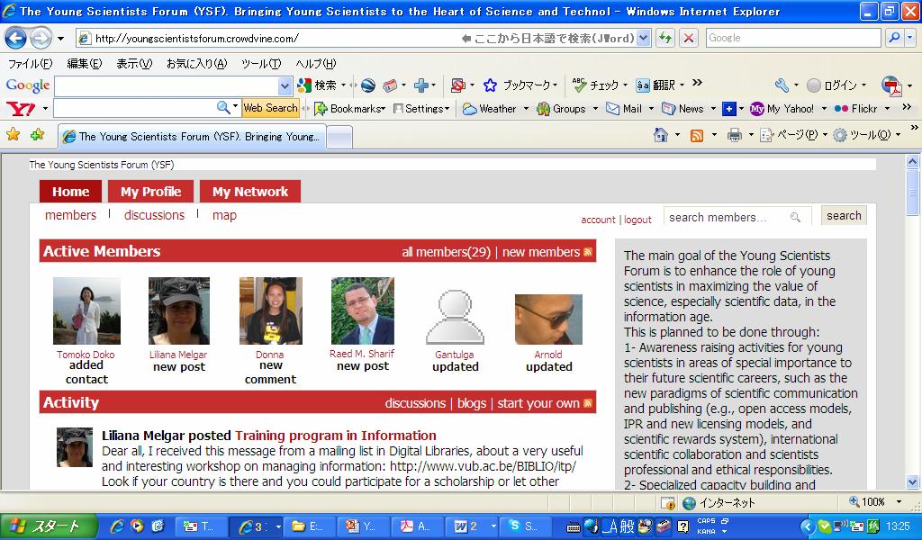
9 YSF communication platform
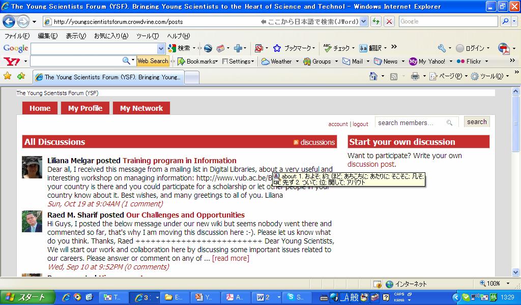
10 Discussion board
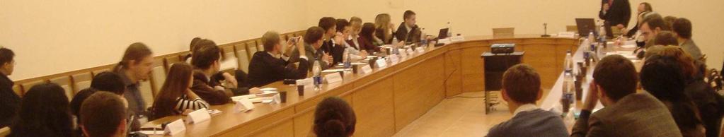
11 Young Scientists Participation at the 21st CODATA International Conference the 21st CODATA International Conference held in Kyiv, Ukraine, Oct.5-8, On October 8, 2008 around 35 young scientists and researchers representing different regions, different scientific disciplines discuss issues of importance and concern to their studies and future careers
12 Discussion topic The possibility to create a Young Scientist Prize. The major obstacles facing young scientists in their fields and/or countries and some potential solutions to overcome these obstacles The role of CODATA in promoting more and better involvement of young scientists in these areas. Suggestions for activities or projects to enhance the role of young scientists in the science and technology policy-making areas, and in maximizing the value of science in the information age in general. The role of young scientists in the science and technology policy making processes


13 Hi, my name is Raed M. Sharif, Ph.D. Candidate in Information Science and Technology at Syracuse University, USA I organized this session. I am a leader of The UN GAID e-sddc Young Scientists Forum!


14

15 Section 2: Global Change Research Case study of Himalayan Glacial Lakes Changes

16 Flood Monitoring and Warning System Imja Glacial Lake Leaded by Prof. Hiromichi FUKUI Professor, Faculty of Policy Management Graduate School of Media and Governance Keio University
17 Objectives To Monitor hydrological and meteorological data affected GLOF hazard. To Establish an effective early warning system for monitoring GLOF hazard using RS, GIS and web mapping in Imja Glacial Lake, a case study. To Disseminate the system to the relevant organization in the region that could maintain and make use of this spatial information for GLOF hazard warning and mitigation planning.
, in the")

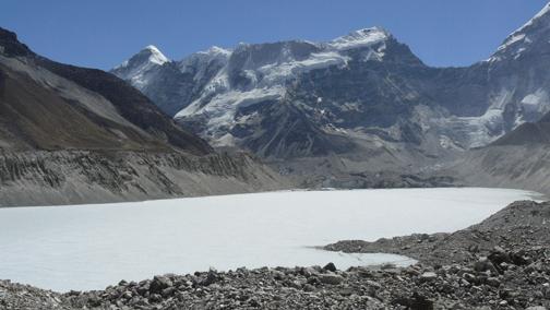
18 Study Area Imja Glacial Lake located at the southern slope of Island Peak (Imja Tse), in the Himalayan Khumbu Range of Eastern Nepal. ASTER Image Date: April, 2001 Resolution: 15 meters R:4G:3B:2
19 Methodology Monitoring Data Collection An inventory of glaciers and glacial lakes In situ Data Satelite Image RS images GIS data Layers Administrative Web Interface Web GIS RSS Others SMS DB Interface PHP Database Server & Communication RDBMS (Postgresql) FTP RSS Boundaries Settlements Digital Elevation Models Geology Soils TCP/IP SMS Gateway Roads River Land Use Geospatial Web Browser SMS/Mobile E Mail RSS

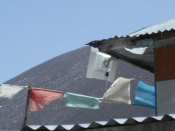
20 Field Server Wireless Antenna A Field Server is a sensor node which can create a wireless sensor network and simultaneously serve as Wi Fi hotspots in open fields. Research and educational applications A global sensor network for Earth observation, food safety/it agriculture, advanced sensor technology in fields and image monitoring for urban areas. Field Server


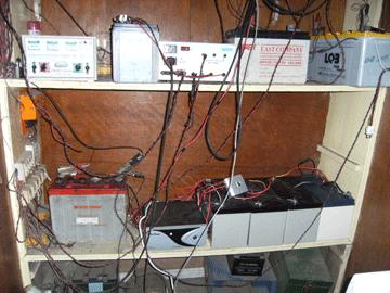
21 Data Transfer Field Server Net National Agricultural Research Center, NARC FS Agent Box IMJA SERVER
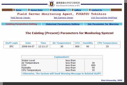
22 Warning System Use Case Warning System Disaster Management Director Setup Initial Values of Meteorological and Hydrological Parameters Responsible Staff I Check Events Responsible Staff n Responsible Staff II
23 Verify User Account [true] Set Parameter Verify User Input behaviour Decision Node [false] Return Login Page Activity Diagram: Verify User Account
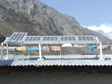
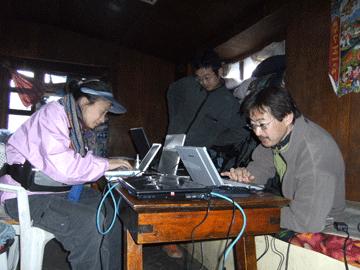
24 Monitoring Parameter Setup sd Set Initial Values - Parameters <<user>> Disaster Management Director <<system>> Set Initial Values for Warning Message 1: Login to the System 2: Parameters Display 3: Set Values 4: Ask for Confirmation 5: Settle Confirmation 6: Displays Setting Values 7: Logout
25 Expected Output Sensor Data Stream, Data Mining and Flood Detection in Data Stream Implement an early warning system for GLOF hazard monitoring to a potential risk lake. Sensoring and Processing system through Web-based. Create useful Information from sensor system and to human engaged in decision making. To disseminate the result to the relevant and potential organization.
26 Chhukung Ri 5,550m. Dingboche 4,410m. Chhukung 4,730m. IMJA 5,010m. Namche Bazarr 3,440m. Internet Networking and Transmission Station
27 Dingboche


28 Wireless Relay at Chhukung Ri (5550 m.)


29 FS Site: End of Moraine (5,100 m.) (Water Level Sensor)


30 FS Site: Island Peak Air Temperature Humidity PPFD (Photosynthetic Photon Flux Density -- Light environment concerning the photosynthesis)


31 Image Capture (11.00 A.M May 29,2009) Namche I National Park Kathmandu NamcheII, Khum Lodge End of Moraine Island Peak Site


32 Imja Website Warning System Data Transfer

33 Message Sent
Frequency Allocations in Remote Sensing (FARS) Technical Committee
 Technical Committee") Frequency Allocations in Remote Sensing (FARS) Technical Committee Annual Meeting! July 14, 2014! Sidharth Misra (Chair)! Paolo de Matthaeis (Co-chair)! Slide 1 Geoscience and Remote Sensing Society GPM
Frequency Allocations in Remote Sensing (FARS) Technical Committee Annual Meeting! July 14, 2014! Sidharth Misra (Chair)! Paolo de Matthaeis (Co-chair)! Slide 1 Geoscience and Remote Sensing Society GPM
United Nations Statistics Division Programme in Support of the 2020 Round of Population and Housing Censuses
 United Nations Statistics Division Programme in Support of the 2020 Round of Population and Housing Censuses Session 2 Srdjan Mrkić United Nations Statistics Division Resolution UN Statistical Commission
UNISDR Science & Technical Committee report and related activities
 UNISDR Science & Technical Committee report and related activities Professor Virginia Murray Member of Science and technical committee for UN International Strategy for Disaster Reduction (UNISDR) International
WFEO STANDING COMMITTEE ON ENGINEERING FOR INNOVATIVE TECHNOLOGY (WFEO-CEIT) STRATEGIC PLAN ( )
 STRATEGIC PLAN ( )") WFEO STANDING COMMITTEE ON ENGINEERING FOR INNOVATIVE TECHNOLOGY (WFEO-CEIT) STRATEGIC PLAN (2016-2019) Hosted by The China Association for Science and Technology March, 2016 WFEO-CEIT STRATEGIC PLAN (2016-2019)
WFEO STANDING COMMITTEE ON ENGINEERING FOR INNOVATIVE TECHNOLOGY (WFEO-CEIT) STRATEGIC PLAN (2016-2019) Hosted by The China Association for Science and Technology March, 2016 WFEO-CEIT STRATEGIC PLAN (2016-2019)
Climate Change and the Himalayan Glaciers: Problems and Prospects
 Climate Change and the Himalayan Glaciers: Problems and Prospects Resolutions of the global e-conference on Climate Change and the Himalayan Glaciers 7-30 May, 2007 Tek Jung Mahat and Samjwal R. Bajracharya
Chapter 11 Cooperation, Promotion and Enhancement of Trade Relations
 Chapter 11 Cooperation, Promotion and Enhancement of Trade Relations Article 118: General Objective 1. The objective of this Chapter is to establish a framework and mechanisms for present and future development
Information Day on EO Exploitation Activities of ESA's Strategic Initiative
 Information Day on EO Exploitation Activities of ESA's Strategic Initiative Norwegian Space Centre Oslo, Norway 2011 March 15 Diego Fernandez Prieto, Espen Volden 1 ESA CLIMATE CHANGE INITIATIVE ESA DATA
- Avenues and Requisites for Successful Collaboration - Indian Space Research Organisation Department of Space Government of India
 Strengthening Regional Resilience with Geo-Information Programme on Trans-boundary Cooperation in South and South East Asia for geospatial information - Avenues and Requisites for Successful Collaboration
Introduction of CSRSR Image product processing systems in CSRSR Disaster monitoring and data processing
 3 rd Joint Project Team Meeting for Sentinel Asia STEP3 Data Analysis Node Report Li-Yu Chang Associate Research Engineer Center for Space and Remote Sensing Research National Central University, Taiwan
GLOF project in Bhutan
 Mt. Khang Bum (6494m) GLOF project in Bhutan Masaru ARAKIDA (Mr) Makoto IKEDA (Mr) Asian Disaster Reduction Center Table of Contents 1. Outline of GLOF Project 2. Past Disaster 3. Output of GLOF Project
SSTDM 2014 _IUSSTF. Team of Students. 1.Sharwan Ram, 2. Abhishek Saini, 3. Ashok Tak, 4. Rahul E B, 5. Sourav Choudhury and 6.
 SSTDM 2014 _IUSSTF CANEUS SSTDM 2014 Technical Presentation of A Concept Paper on A UAV based Autonomous System for surveillance and proclamation of warning during disaster PI Dr. (Er.) Jayanta Kumar Ghosh,
Asia Disaster Reduction Science and Technology Forum on December 4, 2006 BPPT Building II, Jakarta, Indonesia. Tatsuo Narafu
 Outline of Collaborative R&D Project on Network of Research Institutes in Earthquake Prone Areas in Asia supported by Ministry of Education, Culture, Sports, Science and Technology (MEXT) Asia Disaster
ITU Radiocommunication Sector (ITU-R) and Climate Change. Alexandre VASSILIEV ITU Radiocommunication Bureau
 and Climate Change. Alexandre VASSILIEV ITU Radiocommunication Bureau") ITU Radiocommunication Sector (ITU-R) and Climate Change Alexandre VASSILIEV ITU Radiocommunication Bureau WSIS FORUM 2009, Geneva, 18-22 May 2009 Radio and Information Society Today radio technologies
ITU Radiocommunication Sector (ITU-R) and Climate Change Alexandre VASSILIEV ITU Radiocommunication Bureau WSIS FORUM 2009, Geneva, 18-22 May 2009 Radio and Information Society Today radio technologies
NRS 415 Remote Sensing of Environment
 NRS 415 Remote Sensing of Environment 1 High Oblique Perspective (Side) Low Oblique Perspective (Relief) 2 Aerial Perspective (See What s Hidden) An example of high spatial resolution true color remote
Abstract. Keywords: landslide, Control Point Detection, Change Detection, Remote Sensing Satellite Imagery Data, Time Diversity.
 Sensor Network for Landslide Monitoring With Laser Ranging System Avoiding Rainfall Influence on Laser Ranging by Means of Time Diversity and Satellite Imagery Data Based Landslide Disaster Relief Kohei
第 XVII 部 災害時における情報通信基盤の開発
 XVII W I D E P R O J E C T 17 1 LifeLine Station (LLS) WG LifeLine Station (LLS) WG was launched in 2008 aiming for designing and developing an architecture of an information package for post-disaster
Foreword...i Table of Contents... iii List of Figures...vi List of Tables...vi. Executive Summary...vii
 i FOREWORD Timely information on scientific and engineering developments occurring in laboratories around the world provides a critical input to maintaining the economic and technological strength of the
Technische Universität Berlin
 Technische Universität Berlin Content The TU Berlin Habitat Unit Manufacturing Group Water center The DAAD-project History 1770-1821 Founding of the antecedent academies: Mining Academy, Building Academy,
Introduction To Wireless Sensor Networks
 Introduction To Wireless Sensor Networks Wireless Sensor Networks A wireless sensor network (WSN) is a wireless network consisting of spatially distributed autonomous devices using sensors to cooperatively
BRI R&D Initiative on Housing Safety to Mitigate Earthquake Disasters in Collaboration with Research Institutes
 BRI R&D Initiative on Housing Safety to Mitigate Earthquake Disasters in Collaboration with Research Institutes Expert meeting for the Anti-seismic Building Code Dissemination Project (ABCD) for the Housing
An Automated Rainfall Monitoring System
 ENGINEER - Vol. XXXIX, No. 02, pp. 53-58,2006 The Institution of Engineers, Sri Lanka The following paper received... An Automated Rainfall Monitoring System S.P.K.A Gunawardena, B.M.D Rangana & M.M Siriwardena
Article Evolution and controls of large glacial lakes in the Nepal Himalaya
 Article Evolution and controls of large glacial lakes in the Nepal Himalaya Umesh K. Haritashya 1, *, Jeffrey S. Kargel 2, Dan H. Shugar 3, Gregory J. Leonard 4, Katherine Strattman 1, C. Scott Watson
Remote Sensing Science and Sensors for Agricultural Applications
 Remote Sensing Science and Sensors for Agricultural Applications (Feb 20-24, 2018) Venue: Indian Institute of Technology Roorkee, Roorkee-247667, Uttarakhand, India Overview... In the era of smart agriculture,
TOWARD AN INTEGRATED NATIONAL SURFACE OBSERVING NETWORK MALAYSIAN METEOROLOGICAL DEPARTMENT. Nik Mohd Riduan Nik Osman
 TOWARD AN INTEGRATED NATIONAL SURFACE OBSERVING NETWORK MALAYSIAN METEOROLOGICAL DEPARTMENT By Nik Mohd Riduan Nik Osman Malaysian Meteorological Department, Jalan Sultan, 46667 Petaling Jaya, Selangor,
Building the ERA of Knowledge for Growth. Proposals for the 7 th Research Framework Programme
 Building the ERA of Knowledge for Growth Proposals for the 7 th Research Framework Programme 2007-2013 1 Specific Programmes Cooperation Collaborative research Ideas Frontier Research People Human Potential
Profile description of the Chair of Ports and Waterways
 Faculty Civil Engineering and Geosciences Department of Hydraulic Engineering Profile description of the Chair of Ports and Waterways 1. Position of the Chair of Ports and Waterways 1.1 Background With
Result Report on MDRU Joint Project. March, 2016
 Result Report on MDRU Joint Project March, 2016 Contents 1 1.MDRU Overview 2 2.Joint Project Background 3 3.Joint Project Overview 4 4.Feasibility Study Activities 6 5.Conclusion 15 1. MDRU Overview 2
American Chemical Society The ACS International Center
 American Chemical Society The ACS International Center Introduction American Chemical Society (ACS) ACS Vision: Improving people s lives through the transforming power of chemistry ACS Mission: Advance
A COMPREHENSIVE DATABASE OF HIGH-QUALITY RESEARCH. natureindex.com. Track top papers Explore collaborations Compare research performance
 Track top papers Explore collaborations Compare research performance A COMPREHENSIVE DATABASE OF HIGH-QUALITY RESEARCH Compare research output across 165 countries Track research from 375,000+ articles
International initiatives in data sharing: OECD, CODATA and GICSI. Yukiko Fukasaku Innovmond Padova 21 September 2007
 International initiatives in data sharing: OECD, CODATA and GICSI Yukiko Fukasaku Innovmond Padova 21 September 2007 OECD Recommendation with Principles and Guidelines on Access to Research Data from Public
HIGH IMPACT INNOVATIONS TRANSFORMING AUSTRALIAN AGRICULTURE
 NATIONAL RURAL ISSUES HIGH IMPACT INNOVATIONS TRANSFORMING AUSTRALIAN AGRICULTURE Horizon Scan Agriculture is being transformed by technologies that have the capacity to make the entire agricultural supply
Contents of Presentation
 Outline of Collaborative R&D Project on Network of Research Institutes in Earthquake Prone Areas in Asia supported by Ministry of Education, Culture, Sports, Science and Technology (MEXT) Tokyo International
Role of Manufacturers to support Geodetic Infrastructure
 FIG / UN-GGIM-AP / JUPEM Geospatial and GNSS CORS Infrastructure Forum Kuala Lumpur, Malaysia 16-17 Oct 2016 Role of Manufacturers to support Geodetic Infrastructure Neil Ashcroft Leica Geosystems Information
OTB Research Institute for Urban, Housing and Mobility Studies
 OTB Research Institute for Urban, Housing and Mobility Studies Independent research and consultancy services in housing, construction and the built environment OTB Research Institute for Urban, Housing
Supportive publishing practices in DRR: Leaving no scientist behind
 UNISDR Science and Technology Conference on the implementation of the Sendai Framework for Disaster Risk Reduction 2015-2030 Launching UNISDR Science and Technology Partnership and the Science and Technology
Haodong Yang, Ph.D. Candidate
 Haodong Yang, Ph.D. Candidate College of Computing and Informatics Drexel University, Philadelphia, PA 19104 Cell: +1(215)-858-8879 Email: haodong.yang@drexel.edu EDUCATION Ph.D., Information Studies Drexel
Connected Living -- Smart Cities Developing collaborative mobile-based city solutions for smart cities
 Connected Living -- Smart Cities Developing collaborative mobile-based city solutions for smart cities Connected Living Summit, Shanghai, 24 June 2013 Table of Contents Introduction to the GSMA s Smart
Virginia s IFLOWS System and Future Approaches to Dam Safety
 Virginia s IFLOWS System and Future Approaches to Dam Safety Sam Utley Division Manager, Environmental Monitoring Services 3154 State Street, Blacksburg, VA 24060 PH: 540-961-7894 x427 March 10, 2008 MapTech
The Study on the Application of the Intelligent Technology in the Sightseeing Agricultural Parks
 Abstract The Study on the Application of the Intelligent Technology in the Sightseeing Agricultural Parks Lei Feng, Jie Zhao Department of Architecture, Henan Technical College of Construction, Zhengzhou
LEDC state of play in research data management: reports, challenges and perspectives IFLA Building Bridges for Research Data
 LEDC state of play in research data management: reports, challenges and perspectives IFLA Building Bridges for Research Data Librarianship: 17 August 2015 Daisy Selematsela (PhD) daisys@nrf.ac.za Outline
Global Navigation Satellite Systems (GNSS): GPS, GLONASS, GALILEO
: GPS, GLONASS, GALILEO") Global Navigation Satellite Systems ():,, Dr Guergana Guerova Marie Curie Fellow Department of Meteorology and Geophysics Physics Faculty, Sofia University National Culture High School, 13 November 2012,
Global Navigation Satellite Systems ():,, Dr Guergana Guerova Marie Curie Fellow Department of Meteorology and Geophysics Physics Faculty, Sofia University National Culture High School, 13 November 2012,
General Assembly. United Nations A/AC.105/946
 United Nations A/AC.105/946 General Assembly Distr.: General 16 November 2009 Original: English Committee on the Peaceful Uses of Outer Space Report on the United Nations/Azerbaijan/United States of America/European
. Faye Goldman. July Contents
 July 2018 Contents Background... 2 Introduction... 2 A new strategy for 2018-21... 2 Project overview... 2 Project partners... 3 Digital Product Development... 4 What we re looking for... 4 Deliverables...
Design of WSN for Environmental Monitoring Using IoT Application
 Design of WSN for Environmental Monitoring Using IoT Application Sarika Shinde 1, Prof. Venkat N. Ghodke 2 P.G. Student, Department of E and TC Engineering, DPCOE Engineering College, Pune, Maharashtra,
Dialog meeting Convergence Environment Finn-Eirik Johansen, Chair of the board, UiO:Life Science
 Dialog meeting Convergence Environment 2018-2019 Finn-Eirik Johansen, Chair of the board, UiO:Life Science What are life sciences? All scientific disciplines studying the composition, structure and functions
High Performance Computing Systems and Scalable Networks for. Information Technology. Joint White Paper from the
 High Performance Computing Systems and Scalable Networks for Information Technology Joint White Paper from the Department of Computer Science and the Department of Electrical and Computer Engineering With
Evaluation of Connected Vehicle Technology for Concept Proposal Using V2X Testbed
 AUTOMOTIVE Evaluation of Connected Vehicle Technology for Concept Proposal Using V2X Testbed Yoshiaki HAYASHI*, Izumi MEMEZAWA, Takuji KANTOU, Shingo OHASHI, and Koichi TAKAYAMA ----------------------------------------------------------------------------------------------------------------------------------------------------------------------------------------------------------------------------------------------------------
9/12/2011. Training Course Remote Sensing Basic Theory & Image Processing Methods September 2011
 Training Course Remote Sensing Basic Theory & Image Processing Methods 19 23 September 2011 Introduction to Remote Sensing Michiel Damen (September 2011) damen@itc.nl 1 Overview Some definitions Remote
Integrated Data Handling and Visualization
 Integrated Data Handling and Visualization Module of Remote Sensing and GIS Integration Course 2017 Lammert Kooistra, Ron van Lammeren, John Stuiver Environmental Resource Management in the Anthropocene
International Committee on Global Navigation Satellite Systems (ICG) and its Programme on Global Navigation Satellite Systems (GNSS) Applications
 and its Programme on Global Navigation Satellite Systems (GNSS) Applications") and its Programme on Global Navigation Satellite Systems (GNSS) Applications Sharafat Gadimova ICG Executive Secretariat Office for Outer Space Affairs United Nations Office at Vienna a forum to discuss
and its Programme on Global Navigation Satellite Systems (GNSS) Applications Sharafat Gadimova ICG Executive Secretariat Office for Outer Space Affairs United Nations Office at Vienna a forum to discuss
Addressing Global Challenges:
 Addressing Global Challenges: Focusing STI Policy and Funding through a Gendered Lens Sophia Huyer w i g s a t women, technology, society Addressing Global Challenges: Gender and STI for socio-economic
Global Navigation Satellite Systems (GNSS): GPS, GLONASS, GALILEO
: GPS, GLONASS, GALILEO") Global Navigation Satellite Systems ():,, Dr Guergana Guerova Marie Curie Fellow Department of Meteorology and Geophysics Physics Faculty, Sofia University Actual topics in the modern physics, Sofia University,
Global Navigation Satellite Systems ():,, Dr Guergana Guerova Marie Curie Fellow Department of Meteorology and Geophysics Physics Faculty, Sofia University Actual topics in the modern physics, Sofia University,
Radio Mobile. Software for Wireless Systems Planning
 Latin American Networking School (EsLaRed) Universidad de Los Andes Merida Venezuela Javier Triviño and E.Pietrosemoli Radio Mobile Software for Wireless Systems Planning About Radio Mobile It is a tool
AP-FAST: Facility for Accelerating Science & Technology Knowledge Services for SDGs into National Development Plans in Asia and the Pacific
 International Conference: Asia Pacific Policy Dialogue on Water, Energy and Food Security for Poverty Alleviation in Dryland Regions 23 25 November 2016, Rawalpindi, Pakistan AP-FAST: Facility for Accelerating
Space Technology and its Applications for National Development. V Bhanumurthy Outstanding Scientist Scientist, Associate Director, NRSC/ISRO
 Space Technology and its Applications for National Development V Bhanumurthy Outstanding Scientist Scientist, Associate Director, NRSC/ISRO GEO4SDGs THEME: GEO-KNOWLEDGE CONDUIT TO SDGs SUCCESS Geospatial
Annual Progress Report Form
 Appendix 1 Danida Fellowship Centre (DFC) Research Unit Hostrupsvej 22 1950 Frederiksberg Annual Progress Report Form For Danida Fellowship Centre use only Received Date Annual Progress Report Form for
European Nuclear Education Network Association
 European Nuclear Education Network Association STARTING POINT Although the number of nuclear scientists and technologists may appear to be sufficient today in some countries, there are indicators that
Strategic Plan Approved by Council 7 June 2010
 Strategic Plan Approved by Council 7 June 2010 Core Mission The purpose of the American Geophysical Union is to promote discovery in Earth and space science for the benefit of humanity. Core Principles
S&T roadmap and implementation strategy: Perspective from the DRR process
 S&T roadmap and implementation strategy: Perspective from the DRR process Brussels, 29 th November 2018 Annisa Triyanti Young scientists representative, UNISDR Science and Technology Advisory Group (STAG)
Presentation Outline
 Presentation Outline Who and what is RANET? What does RANET do? Core RANET principles and philosophies. Overview of Technologies Satellite Community FM Where does RANET work? Who are we? Just tell me where
n campus Get up and running Your guide to setting up a student community
 n campus Get up and running Your guide to setting up a student community www.theiet.org/oncampus Contents 3 What is an On Campus student community? 3 What sort of activities will the IET support? 4 What
SINCIERE. Sino-Norwegian Centre for Interdisciplinary Environmental Research. Rolf D. Vogt, UiO
 SINCIERE Sino-Norwegian Centre for Interdisciplinary Environmental Research Rolf D. Vogt, UiO OUTLINE Scientific challenges Sustainability Integrated assessment DPSIR philosophy Facilitating cooperation
Self-Read Web Portal User Guide
 Self-Read Web Portal User Guide How to submit your meter reading online This guide covers the following topics: 1. Before you start 2. Submitting your meter reading 3. How to set your reminder preferences
PACIFIC SCIENCE AND TECHNOLOGY ADVISORY GROUP TO UNISDR (PSTAG)
") PACIFIC SCIENCE AND TECHNOLOGY ADVISORY GROUP TO UNISDR (PSTAG) H. JACOT DES COMBES, S.L. HEMSTOCK, T. WILCOX, P. TAYLOR, C. WHITE PRESENTED BY KEVIN MAITAVA OUTLINE International context Regional context
PACIFIC SCIENCE AND TECHNOLOGY ADVISORY GROUP TO UNISDR (PSTAG) H. JACOT DES COMBES, S.L. HEMSTOCK, T. WILCOX, P. TAYLOR, C. WHITE PRESENTED BY KEVIN MAITAVA OUTLINE International context Regional context
EU expert briefing: Thematic context of the Seminar: Overall strategic approach
 EU-China experts seminar on developing a joint initiative for cooperation in research and innovation on Food, Agriculture and Biotechnologies (FAB), Beijing 10-11 October 2013 EU expert briefing: Thematic
Designing Reliable Wi-Fi for HD Delivery throughout the Home
 WHITE PAPER Designing Reliable Wi-Fi for HD Delivery throughout the Home Significant Improvements in Wireless Performance and Reliability Gained with Combination of 4x4 MIMO, Dynamic Digital Beamforming
Signal Processing Techniques for Energy and Spectrum Efficient Wireless Transmitters for 4G/5G Communication
 Signal Processing Techniques for Energy and Spectrum Efficient Wireless Transmitters for 4G/5G Communication (December 22-26, 2017) Venue: Indian Institute of Technology Roorkee, Roorkee-247667, Uttarakhand,
ITU Telecom World 2018 SMART ABC
 Durban 10-13 September ITU Telecom World 2018 SMART ABC Artificial Intelligence Banking Cities Organized by ITU-T Smart ITU Smart solutions make innovative use of ICTs to improve quality of life, efficiency
Global Libraries Challenges - e-libraries on the Agenda!
 - e-libraries on the Agenda! Claudia Lux IFLA President Bielefeld 5.2. 2009 Libraries and Scientists 300 B.C. - Antic Period 6th - 15th Century 16th - 19th Century in Europe Expanding the role of libraries
IGFA BELMONT FORUM (BF)
") IGFA BELMONT FORUM (BF) National Centre for Sustainable Coastal Management (NCSCM), under a Memorandum of Understanding (MoU) with the IGFA BELMONT FORUM (BF) has undertaken research study focusing on
IGFA BELMONT FORUM (BF) National Centre for Sustainable Coastal Management (NCSCM), under a Memorandum of Understanding (MoU) with the IGFA BELMONT FORUM (BF) has undertaken research study focusing on
Satellite Remote Sensing: Earth System Observations
 Satellite Remote Sensing: Earth System Observations Land surface Water Atmosphere Climate Ecosystems 1 EOS (Earth Observing System) Develop an understanding of the total Earth system, and the effects of
DEVELOPMENT OF A HARDWARE AND SOFTWARE SYSTEM FOR METEOROLOGICAL OBSERVATIONS
 DEVELOPMENT OF A HARDWARE AND SOFTWARE SYSTEM FOR METEOROLOGICAL OBSERVATIONS Mikhail Shcherbakov *, Alexey Borisov Altai State Technical University, 656000, Barnaul, Russia Abstract. Article is devoted
Inter and Transdisciplinarity in Social Sciences. Approaches and lessons learned
 Inter and Transdisciplinarity in Social Sciences Approaches and lessons learned Symposium on Sustainability Science, 19 December 2016 Overview 1. The ISSC: short intro 2. ID and TD research 3. ISSC s initiatives:
International comparison of education systems: a European model? Paris, November 2008
 International comparison of education systems: a European model? Paris, 13-14 November 2008 Workshop 2 Higher education: Type and ranking of higher education institutions Interim results of the on Assessment
STRATEGIC FRAMEWORK Updated August 2017
 STRATEGIC FRAMEWORK Updated August 2017 STRATEGIC FRAMEWORK The UC Davis Library is the academic hub of the University of California, Davis, and is ranked among the top academic research libraries in North
Great Minds. Internship Program IBM Research - China
 Internship Program 2017 Internship Program 2017 Jump Start Your Future at IBM Research China Introduction invites global candidates to apply for the 2017 Great Minds internship program located in Beijing
Table of Contents. Graduate and Postdoctoral Studies Fellowship Awards Database GPS-FAD 2012
 Table of Contents Introduction... 2 Where to find GPS-FAD and how to access it:... 2 Log in... 3 Step 1: Enter Departmental Contact Information... 4 Step 2: Choose a competition... 5 Step 3: Add an applicant...
Monitoring Natural Disasters with Small Satellites Smart Satellite Based Geospatial System for Environmental Protection
 Monitoring Natural Disasters with Small Satellites Smart Satellite Based Geospatial System for Environmental Protection Krištof Oštir, Space-SI, Slovenia Contents Natural and technological disasters Current
Increasing Access to Certain North Carolina Environmental Data -- North Carolina Policy Collaboratory Project Update
 Increasing Access to Certain North Carolina Environmental Data -- North Carolina Policy Collaboratory Project Update Submitted on behalf of the North Carolina Policy Collaboratory by W. Christopher Lenhardt,
Role of the amateur and amateur-satellite services in support of disaster mitigation and relief
 Report ITU-R M.2085-1 (11/2011) Role of the amateur and amateur-satellite services in support of disaster mitigation and relief M Series Mobile, radiodetermination, amateur and related satellite services
Computing Requirements of Sri Lankan Scientific Community
 Computing Requirements of Sri Lankan Scientific Community Asanka Dias Faculty of Graduate Studies University of Colombo asankadias@yahoo.com H. M. N. Dilum Bandara HPC Lab, Dept. of Computer Science and
PANELISTS. Towards a Pollution-Free Planet: Accelerating the Sound Management of Chemicals and Waste
 PANELISTS Towards a Pollution-Free Planet: Accelerating the Sound Management of Chemicals and Waste #BeatPollution #Detox Rolph Payet is the Executive Secretary of the Basel, Rotterdam and Stockholm Conventions.
2. Measurement Range / Further specifications of the LOG_aLevel system
 1. Introduction General Acoustics, e.k., founded in 1996, with its origins as an acoustics and sensors research and services partnership, is now a high-end technology producer of sophisticated water level
FIRST BRAIN STORMING SESSION FOR SOUTHERN ENVIS CENTRES ENVIS CENTRE KERALA KERALA STATE COUNCIL FOR SCIENCE TECHNOLOGY AND ENVIRONMENT (KSCSTE)
") FIRST BRAIN STORMING SESSION FOR SOUTHERN ENVIS CENTRES ENVIS CENTRE KERALA KERALA STATE COUNCIL FOR SCIENCE TECHNOLOGY AND ENVIRONMENT (KSCSTE) Dr. Kamalakshan Kokkal Joint Director and ENVIS Coordinator
FIRST BRAIN STORMING SESSION FOR SOUTHERN ENVIS CENTRES ENVIS CENTRE KERALA KERALA STATE COUNCIL FOR SCIENCE TECHNOLOGY AND ENVIRONMENT (KSCSTE) Dr. Kamalakshan Kokkal Joint Director and ENVIS Coordinator
Low-Power WSN-Based Solar-Cell Monitoring System
 Low-Power WSN-Based Solar-Cell Monitoring System Raden Arief Setyawan 1, Soeprapto 1, Hadi Suyono 1, and Rini Nur Hasanah 1 1 Universitas Brawijaya, Malang, Indonesia rarief@ub.ac.id, prapto@ub.ac.id,
Improving Accuracy of FingerPrint DB with AP Connection States
 Improving Accuracy of FingerPrint DB with AP Connection States Ilkyu Ha, Zhehao Zhang and Chonggun Kim 1 Department of Computer Engineering, Yeungnam Umiversity Kyungsan Kyungbuk 712-749, Republic of Korea
Multi Robot Navigation and Mapping for Combat Environment
 Multi Robot Navigation and Mapping for Combat Environment Senior Project Proposal By: Nick Halabi & Scott Tipton Project Advisor: Dr. Aleksander Malinowski Date: December 10, 2009 Project Summary The Multi
Remote sensing radio applications/ systems for environmental monitoring
 Remote sensing radio applications/ systems for environmental monitoring Alexandre VASSILIEV ITU Radiocommunication Bureau phone: +41 22 7305924 e-mail: alexandre.vassiliev@itu.int 1 Source: European Space
ELECTRONIC COMMUNICATIONS COMMITTEE
 ELECTRONIC COMMUNICATIONS COMMITTEE ECC Decision of 12 November 2010 on sharing conditions in the 10.6-10.68 GHz band between the fixed service, mobile service and Earth exploration satellite service (passive)
The European Science Foundation (ESF) is the European association of 78 national research organisations in 30 countries, devoted to scientific
 is the European association of 78 national research organisations in 30 countries, devoted to scientific") The European Science Foundation (ESF) is the European association of 78 national research organisations in 30 countries, devoted to scientific research. ESF Member Organisations 78 in 30 countries Research
The European Science Foundation (ESF) is the European association of 78 national research organisations in 30 countries, devoted to scientific research. ESF Member Organisations 78 in 30 countries Research
IFT STRATEGIC PLAN. 2017/18 Strategic Objectives
 IFT STRATEGIC PLAN 2017/18 Strategic Objectives STRATEGIC STRUCTURE Feeding Tomorrow Mission IFT Mission IFTSA Mission Strategic Priorities Vision Vision Vision Core Values Strategic Objectives VISION
IEEE Project m as an IMT-Advanced Technology
 2008-09-25 IEEE L802.16-08/057r2 IEEE Project 802.16m as an IMT-Advanced Technology IEEE 802.16 Working Group on Broadband Wireless Access 1 IEEE 802.16 A Working Group: The IEEE 802.16 Working Group on
IOT Based Landslide Detection & Prevention System
 IOT Based Landslide Detection & Prevention System Jadhav Kanchan eknath, Nalegaonkar Abhilash Dashrath, Salunke Vaishnavi Pandurang, Rajole Savita Dinkar 1 Author, computer Department, Matoshri college
RESPONSIBLE RESEARCH AND INNOVATION
 RESPONSIBLE RESEARCH AND INNOVATION Jeroen van den Hoven Professor Ethics and Technology Delft University of Technology Chair Expert Group Responsible Research and Innovation Klaus Jacob, e.a. Lino Paula,
2010 World Population and Housing Census Programme. United Nations Statistics Division
 2010 World Population and Housing Census Programme United Nations Statistics Division Overview What is the 2010 World Population and Housing Census Programme? Implementation of Population and Housing Censuses
Detecting Intra-Room Mobility with Signal Strength Descriptors
 Detecting Intra-Room Mobility with Signal Strength Descriptors Authors: Konstantinos Kleisouris Bernhard Firner Richard Howard Yanyong Zhang Richard Martin WINLAB Background: Internet of Things (Iot) Attaching
GENERAL DEVELOPMENT APPLICATIONS. General Submission Requirements
 COMPLETE APPLICATION CHECKLIST Jan 2016 The following checklist has been compiled to assist the applicant in preparing their application for approval pursuant to Ontario Regulation 162/06. This checklist
Bloodhound RMS Product Overview
 Page 2 of 10 What is Guard Monitoring? The concept of personnel monitoring in the security industry is not new. Being able to accurately account for the movement and activity of personnel is not only important
Characteristics and protection criteria for non-geostationary mobile-satellite service systems operating in the band
 Recommendation ITU-R M.2046 (12/2013) Characteristics and protection criteria for non-geostationary mobile-satellite service systems operating in the band 399.9-400.05 MHz M Series Mobile, radiodetermination,
AUTOMATIC WEATHER AND HYDROLOGICAL STATIONS
 AUTOMATIC WEATHER AND HYDROLOGICAL STATIONS METEODATA/HYDRODATA-3000C SERIES Brochure nº 9722.0044 GEONICA, S.A. - Alejandro Rodríguez, nº 22-28039 Madrid - Spain Tel. +34 91 450 51 18 Fax +34 91 459 46