UTILIZING EFCOS DATA FOR DISASTER MMDRRMOC/MMDA-FCIC
|
|
|
- Marion Shields
- 5 years ago
- Views:
Transcription
1 UTILIZING EFCOS DATA FOR DISASTER MMDRRMOC/MMDA-FCIC By RAMON J. SANTIAGO Consultant/Adviser on DRRM Seminar/Workshop on EFCOS Operations 18 February 2016


2 FLOOD CONTROL INFORMATION CENTER & DISASTER RISK REDUCTION AND MANAGEMENT OPERATION CENTER (3 August 2012)
3 SERVE AS AN OPERATIONS COORDINATION AND CONTROL FACILITY FOR MMDA AND MMDRRMC DURING INCLEMENT WEATHER AND EMERGENCIES PROVIDE DECISION SUPPORT SYSTEM FOR MMDA AND MMDRRMC ESTABLISH AND PROVIDE COMMUNICATIONS AND DECISION LINKS AMONG MMDA OPERATING UNITS, METRO LGUS, MMDRRMC, AND NDRRMC DURING CRITICAL SITUATIONS SERVE AS INFORMATION AND KNOWLEDGE CENTER FOR MMDA AND OTHER CLIENTS ON HYDRO- METEOROLOGICAL CONCERNS PROVIDE COMPLEMENTARY PUBLIC SAFETY ADVISORIES AND WARNING MISSION AND FUNCTION
4 MMDA FLOOD CONTROL INFORMATION CENTER/METRO MANILA DISASTER RISK REDUCTION AND MANAGEMENT OPERATION CENTER (FCIC - MMDRRMOC) ORGANIZATIONAL STRUCTURE HEAD ASST HEAD ADMIN SPT STAFF COMMO SPT STAFF PUBLIC INFO SECTION HAZARDS MONITORING & ANALYSIS SECTION MOBILIZATION, OPNS CONTROL & COORDINATION SECTION RESOURCES INVENTORY, PLANS, & RESEARCH SECTION
5 MMDA FLOOD CONTROL INFORMATION CENTER/METRO MANILA DISASTER RISK REDUCTION AND MANAGEMENT OPERATION CENTER (FCIC - MMDRRMOC) FUNCTIONAL STRUCTURE HEAD DIRECTION, GUIDANCE, CONTROL, OVER-ALL SUPERVISION ASST. HEAD ASSIST IN ADMINISTRATION AND TECHNICAL SUPERVISION PERSONNEL, TRAINING & SUPPLY MEDIA, PUBLIC QUERRIES, COMPLAINTS, CENTER BRIEFING ADMIN SPT STAFF PUBLIC AFFAIRS & INFO SECTION COMMO SPT STAFF RADIO, SMS, TELEPHONE, INFO COLLECTION, DISSEMINATION, COMMO MAINT HAZARDS & IMPACT MONITORING & ANALYSIS SECTION MOBILIZATION, OPERATIONS CONTROL, & COORDINATION SECTION RESOURCES INVENTORY, PLANS, & RESEARCH SECTION WEB BROWSING, WARNING RECEPTION & ALERT DISSEMINATION, IMPACT ANALYSIS EMERGENCY MOBILIZATION NOTIFICATION, DEPLOYMENT AND DISPATCH, SERVICES COORDINATION PLANS, RESEARCH, DOCUMENTATION, INVENTORY DATABASE & UPDATE,


6 WARNING/ADVISORY/ SERVICE/RESPONSE DECISION -MAKER/S HAZARD, FLOOD, DISASTER OR EMERGENCY IMPACT AREA, COMMUNITY, PUBLIC FEEDBACK VALIDATION MMDA FCIC MMDRRMOC ACTION AGENCY/IES EMERGENCY RESPONDER/S INFO SOURCE/MED IUM KNOWLEDGE BASE & DECISION SUPPORT TOOLS SUPPORT UNITS WORK PROCESS & COMMUNICATIONS FLOW

7 THUNDERSTORM WARNING
 MEANING WARNING Rainfall of 7.")


8 Philippine Atmospheric, Geophysical and Astronomical Services Administration (PAGASA) HEAVY RAINFALL WARNING LEVELS RAINFALL VALUES (mm) MEANING WARNING Rainfall of 7.5 to 15 mm per hour has fallen or expected to fall and most likely to continue for the next 3 hours. Rainfall of more than 15mm up to 30mm within 1 hour has fallen or expected to fall or if continuous rainfall for the past 3 hours is more than 45mm to 65mm and most likely to continue for the next 3hours. Rainfall of more than 30mm within 1 hour has fallen or expected to fall or if continuous rainfall for the past 3 hours is more than 65mm and most likely to continue for the next 3 hours. Community FLOODING is POSSIBLE in low lying areas and near river channels For flooded areas, receding of flood is expected due to less rainfall. Community FLOODING is THREATHENING in low lying areas and near river channels If flooding occurs, expect a recession of flooding due to less rainfall. Community SERIOUS FLOODING is EXPECTED Take necessary precautionary measures Action Disclaimer: Rainfall threshold values are arbitrary and may vary depending on the area of concern. These will be refined as soon as more data become available.
9 FLOOD IMPACT TO MOTORISTS Flood Depth Flood Level Impact to Motorist Extremely High 36 - above Not passable to all types of vehicle Very High High Not passable to medium vehicles but passable to buses and trucks Not passable to light vehicle but passable to medium vehicles Medium 6-12 Flooded but passable to all types of vehicles Low Below 6 Flooded but passable
10 FCIC protocol when alert is raised by PAGASA or when rain is observed in MM Alert Color Code Rainfall values Duration Rain Category Potential Impact Action Level FCIC Action/s None < 2.5 mm/hr 30 min. Light None Awareness Monitor None mm/hr 1 Hour Moderate Ponding; congestion Awareness Monitor Yellow mm/hr 3 Hours Heavy Pocket flooding Awareness Relay Monitor Orange mm/hr 6 Hours Intense Flooding is threatening Red > 30 mm/hr 12 Hours + Torrential Evacuation on low lying areas for possible flash flood Preparatory Emergency Action Relay Monitor Alert Relay Monitor Mobilize or Dispatch Coordinate

11

12


13

14

15

16

17

18

19

20


21 MMDA FLOOD CONTROL & SEW MGT OFFICE METRO MANILA EMERGENCY COMMUNICATIONS NETWORK NDRRMOC THREATENED OR AFFECTED COMMUNITIES AND GENERAL PUBLIC MMDA EFCOS & PUMPING STATIONS GMA 7 MMDA FCSMO District Opns Engineers MM DRRMC Action Agencies MMDA FCIC/ MMDRRMOC Volunteers 10 Flood Ctrl Bayanihan Zone Alliances MMDA Metro Base 17 Metro LGUs MM Emergency Strike Force HPSEPO Pub Sfty Div Emerg Response Group Task Force UNOS Other MMDA Operating Units TDO Road Emergency Group Task Force RAINBOW

22
23 ISSUES AND NEEDS PRESENTED TO WORLD BANK, 4 JUNE 2014 Latency of Information-crucial to timely decision and credibility Almost real-time links to data source to serves as trigger of timely action and response prior to processed warning from PAGASA (such as Doppler Radar, Project Noah, etc ) Improved Platform for Plotting and Sharing Information and Actions that can be viewed by numerous stakeholders Improved archiving and reporting application to aid flood control measures programming

24
25
26

27

28

29
30

31

32
33

34
35 CONCLUSION IMPROVED ACCESS TO HYDRO-MET INFORMATION TIMELY INFORMATION APPLICABLE TO DISASTER RISK REDUCTION SUCH AS FLOOD FORECASTING FEATURES RELIABLE DATA TRANSMISSION BACKBONE IMPROVED ARCHIVING FOR FLOOD INCIDENCE CORRELATION AND REPORTING
36 OUR VISION.. BECOME ONE OF THE PHILIPPINES CENTERS OF EXCELLENCE ON DISASTER RISK REDUCTION AND MITIGATION
37 THANK YOU VERY MUCH FOR YOUR ATTENTION! HAVE A NICE DAY!


38 Department of Science and Technology Philippine Atmospheric, Geophysical and Astronomical Services Administration FLOOD FORECASTING & WARNING SYSTEM FOR METRO MANILA ENG R. MAXIMO F. PERALTA HYDROMETEOROLOGY DIVISION Philippine Atmospheric Geophysical and Astronomical Services Administration


39 BACKGROUND : T.S. Ketsana crossing Central Luzon

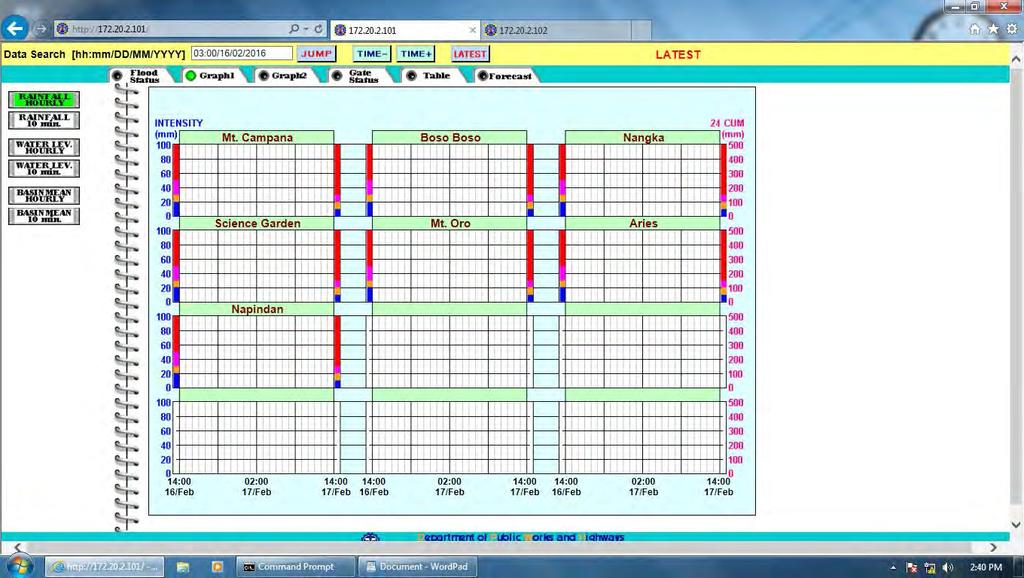
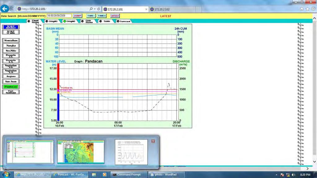
40 IMPACT OF T.C. KETSANA (Ondoy) September 26, 2009 tracking the sky.helping the country


41 Case study: Flood in Metro Manila due to TS Ondoy In 2003, Bankoff described in depth that Metro Manila s vulnerability to flooding has evolved as a result of the degree of interplay between climate, topography, resource use, and culture over time. The flood due to TS Ondoy in Sep 2009 proved it. Intense rainfall Insufficient carrying capacities High/dense population High urbanization level INSUFFICIENT WARNINGS Unabated/rampant development tracking the sky.helping the country Deforestation Informal settlers


42 WATER-RELATED DISASTER MITIGATION MEASURES STRUCTURAL MEASURES NON-STRUCTURAL MEASURES Reduce upstream runoff inflow Dam, reservoir Upstream rain gauge network. Retarding areas Bypass, floodway Channel enlarging Embankment-dike Hydrological stations, Telemetering network. Flood monitoring and early warning system. Evacuation and mitigation operation MOVE THE WATER AWAY FROM THE PEOPLE!! MOVE THE PEOPLE AWAY FROM THE WATER!!

43 To complement the EFCOS Project: ESTABLISHMENT OF EARLY WARNING SYSTEM AND MONITORING SYSTEM FOR DISASTER MITIGATION IN METRO MANILA OR EWS 2 PROJECT TARGET AREA : PASIG-MARIKINA RIVER BASIN - Funded by Korean Government - Established in 2010 after Typhoon Ondoy - Installation was completed in IEC Conducted in Fully Operational in 2014 Project Component : 1. Data Collection System 2. Flood Forecast System 3. Early Warning System 4. Communication Network


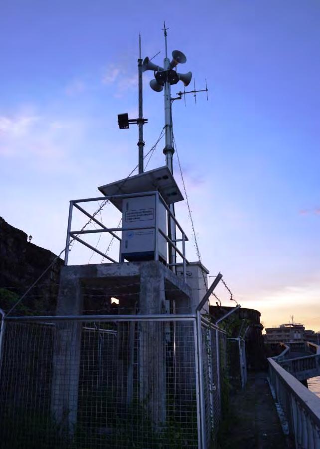


44 Example of Flood Monitoring Equipment:


45 Data Collection System Module: 4 Automatic Weather Stations 10 Rainfall Gauging Stations 10 Waterlevel Gauging Stations

46 Expanded Data Collection System Module: - EFCOS Stations were considered in the design of the Hydrological Network intended for Pasig Marikina River Basin. - The collected data on the said stations were integrated to the system. Location Map of EFCOS Stations 7 Rainfall Stations 11 Waterlevel Gauging Stations


47 FLOOD FORECASTING SYSTEM: PAGASA DIC Monitoring Decision making support
 OF THE")
48 FLOOD FORECASTING SYSTEM: SCREEN SHOT OF GRAPHICAL UNIT INTERFACE (GUI) OF THE SYSTEM


49 EARLY WARNING SYSTEM:

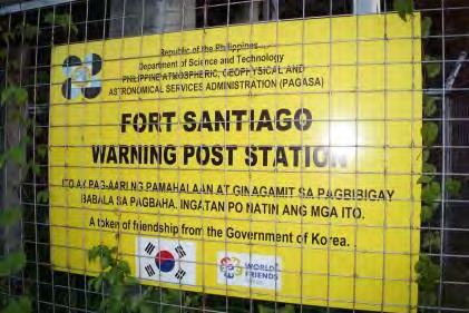
50 EARLY WARNING SYSTEM: - Location of 20 Warning Post along Pasig Marikina River Basin

51 COMMUNICATION SYSTEM: Microwave Communication


52 COMMUNICATION SYSTEM: VHF Radio Communication VHF-1 CH3 data VHF-1 CH4 data VHF-2 CH7 voice PAGASA VHF-1 CH1 데이타용 VHF-1 CH2 데이타용 VHF-2 CH7 음성용 30MHz ~ 300MHz PAGASA Station Data Terminal Marikina River 30MHz ~ 300MHz Mt.Mataba Relay Station VHF communication equipment AWS(4EA) RG (7EA) WL (10EA) WP (20EA) DRR (7EA) Data Terminal DRR Office Pasig River 30MHz ~ 300MHz Antipolo Relay Station VHF-1 CH5 data VHF-1 CH6 data VHF-2 CH7 voice L e g e n d VHF voice

 PAGASA(1EA) Data Terminal Antipolo Relay Station 이동통신사기지국 Pasig River L e g e n")
53 COMMUNICATION SYSTEM: GSM Communication GSM service provider Data Terminal PAGASA PAGASA Station repeater Marikina River Mt.Mataba Relay Station GSM Communication Equipment AWS (4EA) RG (7EA) WL (10EA) WP (20EA) DRR (7EA) PAGASA(1EA) Data Terminal Antipolo Relay Station 이동통신사기지국 Pasig River L e g e n d GSM service provider network Designated line Radio network


54 PAGASA WEBSITE:
55 EXAMPLE OF FLOOD WARNING ACTIVATION DURING THE PASSAGE OF TYPHOON MARIO (SEPTEMBER 14, 2014)

56 RAINFALL INTENSITY of PMRB as of 1:40 AM September 19, 2014
57 STATUS OF WATERLEVEL of PMRB as of 1:40 AM September 19, 2014
58 Rainfall Intensity of PMRB as of 5:40 AM

59 WATERLEVEL of PMRB as of 5:40 AM


60 Alarm Level Alert Level Critical Level
61 STATUS OF WATERLEVEL STATIONS Station Name Alert Alarm Critical 1. MONTALBAN 2. BURGOS 3. SAN MATEO 1 4. NANGKA 5. TUMANA 6. STO.NIÑO 7. MARCOS HIGHWAY 8. ROSARIO JS 9. ROSARIO LS 10. NAPINDAN NAPINDAN MINDANAO 13. SAN JUAN SCHOOL 14. PANDACAN (12:40 AM-Sept 19) (1:50 AM-Sept 19) (3:00 AM-Sept 19) (2:00 AM-Sept 19) (4:30 AM Sept 19 ) (3:10 AM Sept 19) (4:10 AM Sept 19) (2:00AM Sept 19) (6:10 AM Sept 19) (2:50 AM) (6:40 PM Sept 18) (2:20 AM-Sept 19) (2:40 AM-Sept 19) (3:50 AM-Sept 19) (2:40 AM-Sept 19) (6:00 AM-Sept 19) (4:20 AM-Sept 19) (6:00 AM Sept 19) (5:40 AM Sept 19) (7:00 AM Sept 19) (3:00 AM) (2:40 AM Sept 19) (2:40 AM-Sept 19) (3:10 AM-Sept 19) (5:20 AM-Sept 19) (3:00 AM-Sept 19) (6:50 AM-Sept 19) (6:00 AM Sept 19) (7:00 AM Sept 19) (7:30 AM Sept 19) (8:50 AM Sept 19) DID NOT REACHED FLOOD WARNING LEVELS (6:20 PM-Sept 18) (2:50 AM-Sept 19) (6:00 AM) (3:00 AM Sept 19) (6:20 AM-Sept 19)
62 Summary of Warning Post Activation Station Name Alert Alarm Critical REMARKS 1. Eastwood Rodriguez 3:36 AM 4:04 AM 5:52 AM 2. Rodriguez 2 3:36 AM 4:04 AM 5:52 AM 3. Rodriguez 1 3:40 AM 4:04 AM 5:52 AM 4. De la Costa Subdivision 1:35 AM 2:31 AM 4:19 AM 5. Burgos Station 1:45 AM 2:37 AM 3:16 AM 6. San Mateo 2 1:36 AM 2:31 AM 4:19 AM 7. San Mateo 1 3:07 AM 4:01 AM 5:52 AM 8. Nangka 3:10 AM 4:08 AM 5:52 AM 9. Tumana Bridge 3:10 AM 4:08 AM 5:52 AM 10. Sto. Niño 3:10 AM 4:09 AM 5:52 AM 11. Marcos Highway 4:08 AM 5:56 AM 6:27 AM 12. Rosario J.S. 2:11 AM 6:06 AM 13. Rosario L.S. 6:29 AM 10:17 AM 14. People s Park 2:41 AM 3:23 AM 6:02 AM Failure of the Amplifier at the Station caused the unsuccessful sounding of the warning post during the actual operation. 15. San Juan (Pumping 3:06 AM 3:23 AM 6:02 AM

63

64 STRENGTHENING OF EWS2 : AUTOMATION OF FLOOD EARLY WARNING SYSTEM FOR DISASTER MITIGATION IN GREATER METRO MANILA OR EWS 3 PROJECT
 rainfall gauging station and 4 waterlevel gauging stations for PMTRB - To establish 14 warning post and flood monitoring facilities such as CCTV at Tullahan RB - To integrate a flood")
65 Automation of Flood Early Warning System for Disaster Mitigation in Greater Metro Manila or EWS 3 Project Target Areas: Pasig-Marikina-Tullahan River Basin Expected Outcomes: - to establish additional (15) rainfall gauging station and 4 waterlevel gauging stations for PMTRB - To establish 14 warning post and flood monitoring facilities such as CCTV at Tullahan RB - To integrate a flood forecasting and warning system for TRB with the existing system of PMRB On-going Project Target Date of Completion : 2017
66
MARCH 2000 JAPAN INTERNATIONAL COOPERATION AGENCY CTI ENGINEERING INTERNATIONAL CO., LTD.
 DEPARTMENT OF PUBLIC WORKS AND HIGHWAYS REPUBLIC OF THE PHILIPPINES BASIC DESIGN STUDY REPORT ON THE PROJECT FOR REHABILITATION OF THE FLOOD CONTROL OPERATION AND WARNING SYSTEM IN METRO MANILA IN THE
DELAWARE COUNTY PUBLIC WARNING SYSTEM
 Appendix III-3 DELAWARE COUNTY PUBLIC WARNING SYSTEM Appendix III- 3-1 EMERGENCY ALERT SYSTEM (EAS) PLAN FOR DELAWARE COUNTY, NEW YORK PURPOSE 1. To meet Federal guidelines set down for a plan by each
Improvement of emergency response with technology-based solutions
 National Science & Technology Center for Disaster Reduction Improvement of emergency response with technology-based solutions - Pre-disaster relief for reducing impacts by typhoon Liang-Chun Chen Chinese
PUBLIC ALERT: Delivers Emergency All-Hazard Warnings, Everywhere, All the Time
 PUBLIC ALERT: Delivers Emergency All-Hazard Warnings, Everywhere, All the Time DELIVERS EMERGENCY ALL-HAZARD WARNINGS In November 2002, the National Oceanic and Atmospheric Administration (NOAA) and National
ESF 2. Communications
 ESF 2 Communications This page left blank intentionally. 1 Introduction: Purpose and Scope ESF 2 organizes, establishes, and maintains the communications capabilities among appropriate agencies/entities
Metrological Telecommunication System Development Project
 Philippines Metrological Telecommunication System Development Project 1. Project Profile and Japan s ODA Loan Report Date: March 2001 Field Survey: September 2000 The Philippines Manila Cebu Site Map:
Wildland Residents Association, Inc. San Marcos Pass Volunteer Fire Department
 Wildland Residents Association, Inc. San Marcos Pass Volunteer Fire Department By Michael S. Williams President-Executive Director BACKGROUND Recent developments in the commercial broadcasting business
DOST- ASTI Initiatives on the Development of Monitoring Stations and Application of Satellite Technology in Philippine Agriculture
 DOST- ASTI Initiatives on the Development of Monitoring Stations and Application of Satellite Technology in Philippine Agriculture Alvin E. Retamar Chief Science Research Specialist Advanced Science and
PULSE-DOPPLER RADAR-SYSTEM FOR ALPINE MASS MOVEMENT MONITORING
 PULSE-DOPPLER RADAR-SYSTEM FOR ALPINE MASS MOVEMENT MONITORING KOSCHUCH R. IBTP Koschuch e.u., Langegg 31, 8463 Leutschach, Austria, office@ibtp-koschuch.com Monitoring of alpine mass movement is a major
Lincoln County Fire and Rescue Association Standard Operating Guideline (SOG)
") Number: 113 Title: Fire Dispatch Guidelines Purpose: To provide an overview of communications guidelines for fire and rescue departments. 1. Radio Etiquette All Radio users shall comply with all pertinent
Number: 113 Title: Fire Dispatch Guidelines Purpose: To provide an overview of communications guidelines for fire and rescue departments. 1. Radio Etiquette All Radio users shall comply with all pertinent
Targeting a Safer World. Public Safety & Security
 Targeting a Safer World Public Safety & Security WORLD S MOST EFFECTIVE AND AFFORDABLE WIDE-AREA SITUATIONAL AWARENESS Accipiter provides the world s most effective and affordable wide-area situational
System Overview 10/25/2010
 800 MHz CCCS Training 1 As the Emergency Communications Manager for OCSD/Communications and Technology, these are some of the responsibilities of my position. 800 MHz CCCS Training 2 What we want to focus
Urban Classification of Metro Manila for Seismic Risk Assessment using Satellite Images
 Urban Classification of Metro Manila for Seismic Risk Assessment using Satellite Images Fumio YAMAZAKI/ yamazaki@edm.bosai.go.jp Hajime MITOMI/ mitomi@edm.bosai.go.jp Yalkun YUSUF/ yalkun@edm.bosai.go.jp
GAMA Emergency Alerting System Activation Procedures. Ascension Parish, Louisiana February 8, 2008
 GAMA Emergency Alerting System Activation Procedures Ascension Parish, Louisiana February 8, 2008 1 1. For the purpose of integrated emergency management, and to provide guidance for the use and management
Communications and Warning Annex C. County of Kings. Communication & Warning Annex. November County of Kings EOP, 2013 Page 1
 C County of Kings Communication & Warning Annex November 2015 County of Kings EOP, 2013 Page 1 Table of Contents INTRODUCTION... 3 PURPOSE... 3 COMMUNICATION SYSTEMS... 3 COMMUNICATION SYSTEMS VULNERABILITIES...
Comprehensive Emergency Management Plan
 Comprehensive Emergency Management Plan Section 6-Communications Annex Blank Intentionally 2 CEMP Annex 6 5 Communications Annex I. PURPOSE II. POLICY The purpose of this annex is to describe the communications
Fielding of Consultants 04 September November February July 2004
 TECHNICAL ASSISTANCE COMPLETION REPORT Division: AFRM TA No. and Name TA: AFG 3875: Disaster Preparedness and Management Capacity Building Executing Agency: Source of Funding: TASF Department of Disaster
RECOMMENDATION ITU-R M.1310* TRANSPORT INFORMATION AND CONTROL SYSTEMS (TICS) OBJECTIVES AND REQUIREMENTS (Question ITU-R 205/8)
 OBJECTIVES AND REQUIREMENTS (Question ITU-R 205/8)") Rec. ITU-R M.1310 1 RECOMMENDATION ITU-R M.1310* TRANSPORT INFORMATION AND CONTROL SYSTEMS (TICS) OBJECTIVES AND REQUIREMENTS (Question ITU-R 205/8) Rec. ITU-R M.1310 (1997) Summary This Recommendation
Rec. ITU-R M.1310 1 RECOMMENDATION ITU-R M.1310* TRANSPORT INFORMATION AND CONTROL SYSTEMS (TICS) OBJECTIVES AND REQUIREMENTS (Question ITU-R 205/8) Rec. ITU-R M.1310 (1997) Summary This Recommendation
There are not any on site emergency medical facilities in Holberg.
 12.2 HOLBERG Holberg is located on Holberg Inlet which has access to the Pacific Ocean on the west coast of Vancouver Island. Population is approximately 70 persons with the village located mainly at the
2 ESF 2 Communications
 2 ESF 2 Communications THIS PAGE LEFT BLANK INTENTIONALLY ESF 2 Communications Table of Contents 1 Purpose and Scope... ESF 2-1 2 Policies and Agreements... ESF 2-1 3 Situation and Assumptions... ESF 2-1
(P.27)
") (P.27) 27 7 210 120 8 * Navigation and Anchoring Prohibited Area has been changed since June, 2017. 9 Port of Osaka The Guidelines of Measures for preventing Typhoon Disaster ( Objective )
(P.27) 27 7 210 120 8 * Navigation and Anchoring Prohibited Area has been changed since June, 2017. 9 Port of Osaka The Guidelines of Measures for preventing Typhoon Disaster ( Objective )
EMERGENCY SUPPORT FUNCTION #2 COMMUNICATIONS, INFORMATION SYSTEMS AND WARNINGS
 EMERGENCY SUPPORT FUNCTION #2 COMMUNICATIONS, INFORMATION SYSTEMS AND WARNINGS ESF COORDINATOR: LEAD AGENCIES: SUPPORT AGENCIES: Fire Chief Fire Department Communications Program Manager/PIO Department
Game Ready! PARTNERS FOR RESILIENCE Disaster Risk Reduction Game Kit. Facilitator Guidelines RED C R OSS / RED CR ESCENT CLI M AT E C E N T R E
 PARTNERS FOR RESILIENCE Disaster Risk Reduction Game Kit Game Ready! Facilitator Guidelines RED C R OSS / RED CR ESCENT CLI M AT E C E N T R E International Federation of Red Cross and Red Crescent Societies
Emergency Support Function 2. Communications. Iowa County Emergency Management Agency
 Emergency Support Function 2 Communications ESF Coordinator: Iowa County Emergency Management Agency Primary Agencies: Iowa County Communications E 9-1-1 Center Support Agencies: Iowa County Emergency
United nation, Vienna, 9-13 February 2015
 United nation, Vienna, 9-13 February 2015 RUSSIAN FEDERAL SPACE AGENCY In the Russian Federation, the federal agency in charge of space activities is the Russian Federal Space Agency (Roscosmos) Earth
Appendix D Warning System Guidelines. Draft
 Appendix D Draft Dane County/Madison Metropolitan Area Evacuation Plan Appendix D Warning System Guidelines Draft Version 2.0 11/21/2007 Dane County Guidelines for Local Officials Contents: Dane County
Allied Radio Matrix for Emergency Response (ARMER) Standards, Protocols, Procedures
 Standards, Protocols, Procedures") Allied Radio Matrix for Emergency Response (ARMER) Standards, Protocols, Procedures Document Section: 3 Interoperability Standards Status: Complete Sub Section: State Procedure Title: 800 MHz Statewide
Allied Radio Matrix for Emergency Response (ARMER) Standards, Protocols, Procedures Document Section: 3 Interoperability Standards Status: Complete Sub Section: State Procedure Title: 800 MHz Statewide
Virginia s IFLOWS System and Future Approaches to Dam Safety
 Virginia s IFLOWS System and Future Approaches to Dam Safety Sam Utley Division Manager, Environmental Monitoring Services 3154 State Street, Blacksburg, VA 24060 PH: 540-961-7894 x427 March 10, 2008 MapTech
WIRELESS FLOOD DETECTION SYSTEM
 WIRELESS FLOOD DETECTION SYSTEM Dr. Jillella Venkateswara Rao Professor, Department of ECE, Vignan Institute of Technology and Science, Hyderabad, (India) ABSTRACT This paper aims to create a reasonable
Water Level Monitoring and Flood Alert System
 Water Level Monitoring and Flood Alert System Shivaray shenoy.a, Shrinath P.S, Sharath. S, Balapradeep K.N shivaray9414@gmail.com, shrinathps0099@gmail.com, sharath.s55@gmail.com, deepkatoor@gmail.com
Introduction to Systems Approach and Backwards Planning
 Tuesday, 14 October, 14:15 15:00 PM Session 2 Introduction to Systems Approach and Backwards Planning John T. Snow, PhD, CCM CTA Meteorology, Climate Monitoring and Forecasting Caveat and Disclaimer Caveat:
Business Plan Summary
 Owner: 2012-2016 Business Plan Summary Program Corporate, Operational & Council Services Service grouping Corporate Services Service Type Internal Service Mike Bushby Division Manager Fleet Services and
VOLUSIA COUNTY SHERIFF S OFFICE FIRE/EMS COMMUNICATIONS CENTER
 VOLUSIA COUNTY SHERIFF S OFFICE FIRE/EMS COMMUNICATIONS CENTER COMMUNICATIONS POLICIES AND PROCEDURES POLICY# C-01.01 SUBJECT: RADIO INFORMATION ISSUING AUTHORITY: RESCINDS: 07 SEPTEMBER 2002 DATE ISSUED:
Appendixes. 1. Member List of the Study Team. 2. Study Schedule. 3. List of Parties Concerned in the Recipient Country
 Appendixes 1. Member List of the Study Team 2. Study Schedule 3. List of Parties Concerned in the Recipient Country 4. Minutes of Discussions (Study Period) 5. Minutes of Discussions (Explanation of the
Drones and Broadband Data for the PSAP The Role of Robotics and Artificial Intelligence
 Drones and Broadband Data for the PSAP The Role of Robotics and Artificial Intelligence Barry H. Luke, Deputy Executive Director Thursday, April 13, 2017 APCO Western Regional Conference Ontario, California
GNSS-R for Land Bio-Geophysical Parameters Monitoring: the LEiMON Project
 GNSS-R for Land Bio-Geophysical Parameters Monitoring: the LEiMON Project Alejandro Egido(1), Marco Caparrini(1), Leila Guerriero(2), Nazzareno Pierdicca(2), Simonetta Paloscia(3), Marco Brogioni(3), Nicolas
Collection and processing system of hydrological data during flash floods on the River Yodo
 Collection and processing system of hydrological data during flash floods on the River Yodo Tojiro Ishihara, Yutaka Inada and Masao Hayashi Abstract. The data collection and processing system required
ABIS 16 th Annual Colloquium Sustainable Development Goals and Data Science. Jikyeong Kang, PhD. President, CEO, and Dean.
 ABIS 16 th Annual Colloquium Sustainable Development Goals and Data Science Jikyeong Kang, PhD President, CEO, and Dean 16 November 2017 Today I will speak on 1 2 3 Sustainable Development and AIM An Overview
A Wireless Smart Sensor Network for Flood Management Optimization
 A Wireless Smart Sensor Network for Flood Management Optimization 1 Hossam Adden Alfarra, 2 Mohammed Hayyan Alsibai Faculty of Engineering Technology, University Malaysia Pahang, 26300, Kuantan, Pahang,
Amateur Radio Emergency Communications Interoperability Plan
 Amateur Radio Emergency Communications Interoperability Plan Washington State Regional Homeland Security Coordination District IV Clark County Cowlitz County Skamania County Wahkiakum County v1.0 adopted:
EMERGENCY SUPPORT FUNCTION #2 COMMUNICATIONS
 COORDINATING AGENCY PRIMARY AGENCIES: Guernsey County Emergency Management Agency Guernsey County Sheriff s Office Cambridge Police Department SUPPORT AGENCIES: I. Introduction Guernsey County Fire Departments
THE BEST FIT DIGITAL TELEVISION STANDARD FOR THE PHILIPPINES
 ISDB T (Integrated Services Digital Broadcast Terrestrial) THE BEST FIT DIGITAL TELEVISION STANDARD FOR THE PHILIPPINES October 10, 2008 James Rodney P. Santiago Consultant ARIB/Digital Broadcast Experts
Contents. Radar and Flood Forecast System. Study Area and Biseulsan Radar. Hydrologic Analysis of Radar Rainfall. Conclusions
 Contents 1 Motivations and Objective 2 3 4 5 Radar and Flood Forecast System Study Area and Biseulsan Radar Hydrologic Analysis of Radar Rainfall Conclusions Motivations and Objective In order to prevent
Weather Alert Clock Radio with Flashing Beacon. Owner s manual
 Weather Alert Clock Radio with Flashing Beacon Owner s manual NEED HELP? CONTACT US. Etón Corporation, 1015 Corporation Way, Palo Alto, CA 94303, USA. 1-800-872-2228 (U.S.); 1-800-637-1648 (Canada); 650-903-3866
Public Safety Interoperable Communications (PSIC)
") State of New Mexico Department of Information Technology 2013 National Association of State Chief Information Officers State IT Recognition Awards Public Safety Interoperable Communications (PSIC) Category:
State of New Mexico Department of Information Technology 2013 National Association of State Chief Information Officers State IT Recognition Awards Public Safety Interoperable Communications (PSIC) Category:
Pierce County Comprehensive Emergency Management Plan EMERGENCY SUPPORT FUNCTION 2 COMMUNICATIONS
 EMERGENCY SUPPORT FUNCTION 2 COMMUNICATIONS ESF COORDINATOR Pierce County Department of Emergency Management JOINT PRIMARY AGENCIES Pierce County Department of Emergency Management Pierce County Information
ITU and ITU-R Vadim Nozdrin Study Group Department Radiocommunication Bureau
 ITU and ITU-R Vadim Nozdrin Study Group Department Radiocommunication Bureau International Telecommunication Union ITU Facts Founded in 1865 193 Member States > 700 Sector members > 100 Academies 4 regional
A FRENCH PILOT FLOOD WARNING SYSTEM : THE GARI) EXPERIMENT.
 EXPERIMENT.") A FRENCH PLOT FLOOD WARNNG SYSTEM : THE GAR) EXPERMENT. 22 q 13 Jean LEO US SO^ Direction Départementale de 1'Equipement du Gard 89, Avenue Weber 30032 Nîmes cedex. France. T W m b277y nstitut Francais
A FRENCH PLOT FLOOD WARNNG SYSTEM : THE GAR) EXPERMENT. 22 q 13 Jean LEO US SO^ Direction Départementale de 1'Equipement du Gard 89, Avenue Weber 30032 Nîmes cedex. France. T W m b277y nstitut Francais
Royal Canadian Mounted Police Port Hardy Detachment There are no on-site emergency medical facilities in Holberg.
 PART 4.3 HOLBERG 4.3.1 Overview Holberg is located on Holberg Inlet which has access to the Pacific Ocean on the west coast of Vancouver Island. Population is approximately 100 persons, with the village
Basic IMS A R E S. Amateur Radio Emergency Communications. IMS For Amateur Radio. Self Study Training Course. Amateur Radio Emergency Service
 AR-IMS-013 Self Study Training Course Amateur Radio Emergency Communications A R E S Amateur Radio Emergency Service IMS For Amateur Radio Basic IMS Prepared By: Peter Gamble VE3BQP Last Change: 2011-04-10
A Distributed Collaborative Adaptive Sensing System: A Feasibility Plan for Korea. Sanghun Lim Colorado State University Dec.
 A Distributed Collaborative Adaptive Sensing System: A Feasibility Plan for Korea Sanghun Lim Colorado State University Dec. 17 2009 Outline q The DCAS concept q X-band Radar Network and severe storms
ESF 2. Communications
 ESF 2 Communications This page left blank intentionally. 1 Introduction: Purpose and Scope ESF 2 organizes, establishes, and maintains the communications capabilities among appropriate agencies/entities
DELIVERING THE INDUSTRY S FIRST DISASTER AND SAFETY AUTOMATIONS
 DELIVERING THE INDUSTRY S FIRST DISASTER AND SAFETY AUTOMATIONS About Us - Only Disaster Automations company in existence with our extensive partnerships and capabilities - Covering 98% of the US population
NIMS UPDATE 2017 RUPERT DENNIS, FEMA REGION IV, NIMS COORDINATOR. National Preparedness Directorate / National Integration Center.
 NIMS UPDATE 2017 RUPERT DENNIS, FEMA REGION IV, NIMS COORDINATOR National Preparedness Directorate / National Integration Center May 8, 2018 National Incident Management System (NIMS) Overview NIMS provides
4-3-2 Renewal of the Radars of Rainfall Information System: Tokyo Amesh
 4-3-2 Renewal of the Radars of Rainfall Information System: Tokyo Amesh Tadahisa KOBUNA, Yoshinori YABUKI Staff Member and Senior Staff, Facilities Management Section, Facilities Management and Maintenance
International Amateur Radio Union Region 3 report to the Global Amateur Radio Conference 2013, Zurich, Switzerland.
 International Amateur Radio Union Region 3 report to the Global Amateur Radio Conference 2013, Zurich, Switzerland. Author: Jim Linton VK3PC, Chairman, IARU R3, Disaster Communications Committee. Disasters
Philippines Promotes Technological Self- Reliance: Achievements, Current Activities and Future Plans on Space Technology Applications
 Philippines Promotes Technological Self- Reliance: Achievements, Current Activities and Future Plans on Space Technology Applications Clarinda G. Reyes Department of Science and Technology Philippine Council
Strategic Plan Approved by Council 7 June 2010
 Strategic Plan Approved by Council 7 June 2010 Core Mission The purpose of the American Geophysical Union is to promote discovery in Earth and space science for the benefit of humanity. Core Principles
INNOVATIVE DEPLOYMENT OF DYNAMIC MESSAGE SIGNS IN SAFETY APPLICATIONS
 INNOVATIVE DEPLOYMENT OF DYNAMIC MESSAGE SIGNS IN SAFETY APPLICATIONS L.A. Griffin Director of Expressway Operations, Orlando-Orange County Expressway Authority 4974 ORL Tower Road Orlando, FL 32807 (407)
Simulated Emergency Test 2018 Communications Exercise Plan Saturday, October 13, a.m. to 12 noon HST
 Simulated Emergency Test 2018 Communications Exercise Plan Saturday, October 13, 2018 9 a.m. to 12 noon HST Introduction: The Simulated Emergency Test (SET) is an annual communications exercise sponsored
2017 NIMS Update. John Ford, National Integration Center
 2017 NIMS Update John Ford, National Integration Center Outline NIMS Update Background Key Changes NIMS Roll Out Discussion 2 NIMS Refresh History FEMA led a whole community effort to review and refresh
SAN DIEGO COUNTY MUTUAL AID RADIO PLAN
 ATTACHMENT A SAN DIEGO COUNTY MUTUAL AID RADIO PLAN 1.1 General Mutual aid channels are a critical part of San Diego County's radio system requirements. The San Diego County Mutual Aid Radio Plan will
Flood Notice / Information (by Dial-up Connection) Local Authority. (by Dial-up Connection) Flood Notice / Information
 Local Authority. (by Dial-up Connection) Flood Notice / Information") Station of DRHT [Meteo-hydrological Obserbation] (Manual Observation) Flood Information (Tel. by Voice Communication) Flood Information (BLU or VHF by Voice Communication) DPE DRHT [Data Collection] Provincial
Station of DRHT [Meteo-hydrological Obserbation] (Manual Observation) Flood Information (Tel. by Voice Communication) Flood Information (BLU or VHF by Voice Communication) DPE DRHT [Data Collection] Provincial
ISO Environmental Technology Verification
 Framework ISO 14034 Environmental Technology Verification Process Solutions Results TRIECA 2018 Conference - March 21-22, 2018 John Neate, VerifiGlobal Global performance testing and verification platform
I-85 Integrated Corridor Management. Jennifer Portanova, PE, CPM Sreekanth Sunny Nandagiri, PE, PMP
 Jennifer Portanova, PE, CPM Sreekanth Sunny Nandagiri, PE, PMP SDITE Meeting, Columbia, SC March 2017 Agenda The I-85 ICM project in Charlotte will serve as a model to deploy similar strategies throughout
Location of assessment:
 INITIAL RAPID ASSESSMENT COMMUNITY ENGAGEMENT AND ACCOUNTABILITY SULAWESI EARTHQUAKE AND TSUNAMI 10 October, 2018 Initial Rapid Assessment CEA Sulawesi Earthquake and Tsunami Page 2 EARTHQUAKE AND TSUNAMI
San Mateo County Fire Service POLICIES AND STANDARDS MANUAL
 Purpose: Policy: The purpose of this policy is to establish a standard procedure for the use of radio frequencies. This standard radio procedure will be used in the four geographical radio zones that currently
TETRA Association Seminar 2015 OIL & GAS MARKET. Bangkok
 TETRA Association Seminar 2015 TETRA FOR RAIL AND OIL & GAS MARKET Bangkok 9 June 2015 AGENDA Motorola Solutions TETRA for Rail TETRA for Oil & Gas OUR FOCUS WE HELP CREATE SAFER CITIES AND THRIVING BUSINESSES
Cutting-edge Technology for Data and Communications
 Cutting-edge Technology for Data and Communications PAGE 1 Guido Perez Business Development Manager 617-671-5747 g.perez@mstglobal.com Table of Contents TUNNEL & COMMUNICATION EVOLUTION CHALLENGES IN TUNNELS
National Incident Management System
 National Incident Management System Overview Briefing September, 2006 Shelley S. Boone, II DHS-FEMA, Region IV Homeland Security Presidential Directive 5 National Incident Management System (NIMS) A consistent
Customer Showcase > Defense and Intelligence
 Customer Showcase Skyline TerraExplorer is a critical visualization technology broadly deployed in defense and intelligence, public safety and security, 3D geoportals, and urban planning markets. It fuses
911 Telephone Outage Emergency (TOE)
") 911 Telephone Outage Emergency (TOE) An emergency message that defines a local or state 9-1-1 telephone network outage by geographic area or telephone exchange. Authorized officials should provide alternative
911 Telephone Outage Emergency (TOE) An emergency message that defines a local or state 9-1-1 telephone network outage by geographic area or telephone exchange. Authorized officials should provide alternative
WiForWater. Value from information. Hydrologic risk monitoring and advanced management
 WiForWater Value from information Hydrologic risk monitoring and advanced management Scenario The future of the hydrological risk The future of the hydrological risk management is prevention through monitoring
FY 2008 (October 1, 2007 September 30, 2008) NIMS Compliance Objectives and Metrics for Local Governments
 NIMS Compliance Objectives and Metrics for Local Governments") FY 2008 (October 1, 2007 September 30, 2008) NIMS Compliance Objectives and Metrics for Local Governments Introduction Homeland Security Presidential Directive (HSPD)- 5 Management of Domestic Incidents
FY 2008 (October 1, 2007 September 30, 2008) NIMS Compliance Objectives and Metrics for Local Governments Introduction Homeland Security Presidential Directive (HSPD)- 5 Management of Domestic Incidents
Transportation. Growth Management Policy Board April 4, 2019
 Transportation Growth Management Policy Board April 4, 2019 Overview Transportation in VISION 2040 Changes since the adoption of VISION 2040 Feedback to date Potential updates to the Transportation chapter
The Philippines SHARE Program in Aerial Imaging
 The Philippines SHARE Program in Aerial Imaging G. Tangonan, N. Libatique, C. Favila, J. Honrado, D. Solpico Ateneo Innovation Center This presentation is about our ongoing aerial imaging research in the
Emergency Response/Recovery Plan
 Emergency Response/Recovery Plan Revised June 2010 Introduction This document outlines the WGCU Public Media personnel and procedures plan in response to a hurricane or other declared natural disaster.
San Francisco Bay Area Regional Emergency Coordination Plan
 San Francisco Bay Area Regional Emergency Coordination Plan RECP Communications Subsidiary Plan Prepared by Governor s Office of Emergency Services Cities of Oakland, San Francisco, and San Jose Counties
Finding New Ground for Advancing Hydro-Climatic Information Use Among Small Water Systems
 Finding New Ground for Advancing Hydro-Climatic Information Use Among Small Water Systems Rebecca Page University of Colorado Boulder Environmental Studies Program Western Water Assessment April 25, 2018
Disaster Prevention System Utilizing Social Media Information
 Disaster Prevention System Utilizing Social Media Information Naoshi Morita Makoto Hayakawa Norisuke Takao Information on disasters has conventionally been obtained by using physical sensors such as water/rain
Concept of Periodic Synthesis Report
 Concept of Periodic Synthesis Report There is no lack of scientific knowledge, but it is fragmented and not easily accessible to policy makers and practitioners. The Sendai Science and Technology Roadmap
Amarillo College Emergency Notification Systems and Procedures
 Amarillo College Emergency Notification Systems and Procedures Amarillo College (AC) utilizes overlapping communication tools to provide immediate campus-wide emergency notification to the students and
Meeting 10 8 August 2018 Agenda Item 2.1. MSI Self Assessment NAVAREA XVI. Submitted by PERÚ - DIRECTORATE OF HYDROGRAPHY AND NAVIGATION SUMMARY
 WWNWS10 WWNWS10/2/1-XVI Meeting 10 8 August 2018 Agenda Item 2.1 MSI Self Assessment NAVAREA XVI Submitted by PERÚ - DIRECTORATE OF HYDROGRAPHY AND NAVIGATION SUMMARY Executive Summary: Report of activities
JOB DESCRIPTION. Coachella Valley Water District October 12, DEPARTMENT: Facilities and Maintenance REPORTING RELATIONSHIP:
 Coachella Valley Water District October 12, 2017 TITLE: Electronic Technician II SECTION: Electronics Shop DEPARTMENT: Facilities and Maintenance REPORTING RELATIONSHIP: Reports to: Electronics Supervisor,
SAN FRANCISCO EMERGENCY MEDICAL SERVICES AGENCY EMS COMMUNICATIONS EQUIPMENT AND PROCEDURES
 I. PURPOSE SAN FRANCISCO EMERGENCY MEDICAL SERVICES AGENCY Policy Reference No.: 3010 Review Date: January 1, 2011 Supersedes: June 1, 2004 EMS COMMUNICATIONS EQUIPMENT AND PROCEDURES A. To prescribe and
DATACAR ADVANCED MULTILANE TRAFFIC MONITORING SYSTEM
 DATACAR Doc 9723 0030 ADVANCED MULTILANE TRAFFIC MONITORING SYSTEM Suitable both for permanent and temporary installations Non-Intrusive System Accurate detection, speed, counting and classifying traffic
Concept of Operations. Emergency Support Function (ESF) # 2 Communications
 # 2 Communications") Concept of Operations Lead Agency Support Agencies Emergency Support Function (ESF) # 2 Communications Franklin County Sheriff s Office (FCSO) Amateur Radio Emergency Services (ARES) Apalachicola Police
Concept of Operations Lead Agency Support Agencies Emergency Support Function (ESF) # 2 Communications Franklin County Sheriff s Office (FCSO) Amateur Radio Emergency Services (ARES) Apalachicola Police
SYSTEM ARCHITECTURE OF RADAR NETWORK FOR MONITORING OF HAZARDOUD WEATHER
 SYSTEM ARCHITECTURE OF RADAR NETWORK FOR MONITORING OF HAZARDOUD WEATHER 2008. 11. 21 HOON LEE Gwangju Institute of Science and Technology &. CONTENTS 1. Backgrounds 2. Pulse Compression 3. Radar Network
Bhutan: Adapting to Climate Change through Integrated Water Resources Management
 Completion Report Project Number: 46463-002 Technical Assistance Number: 8623 August 2017 Bhutan: Adapting to Climate Change through Integrated Water Resources Management This document is being disclosed
An Automated Rainfall Monitoring System
 ENGINEER - Vol. XXXIX, No. 02, pp. 53-58,2006 The Institution of Engineers, Sri Lanka The following paper received... An Automated Rainfall Monitoring System S.P.K.A Gunawardena, B.M.D Rangana & M.M Siriwardena
Active Road Management Assisted by Satellite. ARMAS Phase II
 Active Road Management Assisted by Satellite ARMAS Phase II European Roundtable on Intelligent Roads Brussels, 26 January 2006 1 2 Table of Contents Overview of ARMAS System Architecture Field Trials Conclusions
Digital Applications for Smart / Intelligent Cities
 Digital Applications for Smart / Intelligent Cities Contents URENIO RESEARCH AT THE ARISTOTLE UNIVERSITY OF THESSALONIKI AND INTELSPACE S.A. An integrated portfolio of applications for smart cities...
In preparing any country program or strategy, financing any project, or by making any designation of or reference to a particular territory or
 April 2018 Quarterly Summary Report on Approved (A) Transaction Technical Assistance Not Exceeding $5,000,000; (B) Knowledge and Support Technical Assistance Projects Not Exceeding $225,000; and (C) Technical
GLOF project in Bhutan
 Mt. Khang Bum (6494m) GLOF project in Bhutan Masaru ARAKIDA (Mr) Makoto IKEDA (Mr) Asian Disaster Reduction Center Table of Contents 1. Outline of GLOF Project 2. Past Disaster 3. Output of GLOF Project
A State Toolkit for Adopting IPAWS
 A State Toolkit for Adopting IPAWS The State Toolkit for adopting IPAWS supports State emergency management officials communications, with county and local officials and the people they serve, about the
A STUDY OF FREEWAY TRAFFIC INFORMATION REPORTED VIA COMMERCIAL RADIO. Conrad L. Dudek. John D. Friebele. and. Roy C. Lautzenheiser
 A STUDY OF FREEWAY TRAFFIC INFORMATION REPORTED VIA COMMERCIAL RADIO by Conrad L. Dudek John D. Friebele and Roy C. Lautzenheiser Research Report Number 139-8 Freeway Control and Information Systems Research
Disaster Emergency Communications (DEC) Group
 Group") Disaster Emergency Communications (DEC) Group Overview 5/13/2013 Greg Boren Region VI RECC Coordinator 1 Denton FRC Communications Capability HF Two groups of transmitters Voice/Phone Patch/Data (Rockwell
Disaster Emergency Communications (DEC) Group Overview 5/13/2013 Greg Boren Region VI RECC Coordinator 1 Denton FRC Communications Capability HF Two groups of transmitters Voice/Phone Patch/Data (Rockwell
4-10 Development of the CRL Okinawa Bistatic Polarimetric Radar
 4-10 Development of the CRL Okinawa Bistatic Polarimetric Radar NAKAGAWA Katsuhiro, HANADO Hiroshi, SATOH Shinsuke, and IGUCHI Toshio Communications Research Laboratory (CRL) has developed a new C-band
TRAINING BULLETIN. EFFECTIVE DATE: 05/06 DOC NO: TB198 CROSS REF: Communications Checklists
 INTRODUCTION Communications Support 131 (CS131) is an important asset of the District and plays a significant role in the county and region. The unit has many communications assets, including radios on
Weather Radar Systems. General Description
 General Description Our weather radars are designed for precipitation monitoring at both regional and urban scales. They can be advantageously used as gap filler of existing radar networks particularly