GLOF project in Bhutan
|
|
|
- Veronica Johns
- 5 years ago
- Views:
Transcription
 Makoto IKEDA (Mr) Asian Disaster Reduction")
1 Mt. Khang Bum (6494m) GLOF project in Bhutan Masaru ARAKIDA (Mr) Makoto IKEDA (Mr) Asian Disaster Reduction Center
2 Table of Contents 1. Outline of GLOF Project 2. Past Disaster 3. Output of GLOF Project 4. Conclusion
3 1. Outline of GLOF Project
4 Background n Some of Asian countries have GLOF risk, and building measures are urgent. n There are many documents of GLOF, however it is not easy to recognize the mechanism and countermeasure of GLOF. n It is necessary to make handbook or brochure to explain local residents. n It is also important to share information and to building capability in regional level.


5 Cooperation Glacial Lake Outburst Flood Monitoring Working Group Information Sharing through SA Step2 Proposal for Satellite Application Field Survey IMJA Project Chubu Unv. Monitoring Imja Glacial Lake International Community ICIMOD* ADRC GLOF Project (Bhutan) ADRC** EWS Hazard Risk Mapping Capacity Building JAXA*** * The International Centre for Integrated Mountain Development ** Asian Disaster Reduction Center *** Japan Aerospace Exploration Agency Providing digital elevation data
6 GLOF project in Bhutan Term n FY 2010 FY 2011 Goal n n Sharing experience of countermeasures of GLOF in other area in Bhutan and other countries Strengthen capacity building concerning GLOF
7 GLOF project in Bhutan / Output n Development methods to develop hazard map. n Supporting capacity building of disaster risk reduction though workshop. n Making Countermeasure Manual of GLOF for Bhutan and other countries has similar risk.

8 GLOF project in Bhutan / Activity Gathering data Making hazard risk map Integrate sustainable early warning system Capacity development in school and community Making manual Sharing information
9 GLOF project in Bhutan / Inputs From Japan side (ADRC) n n n n n n Digital elevation data for making Topographic map (JAXA) Some simulation model for making hazard maps Flooding scenario Setting-up monitoring and EWS Town watching method International Workshop


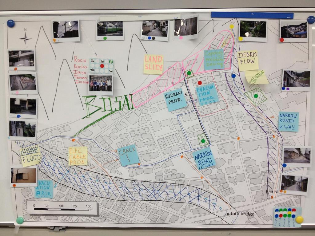
10 Community Based Hazard Mapping ~Effective tool for raising public awareness~ Step 1 Field Survey Residents, Officers in Local Govt. and Experts survey the positive and negative features relating to the disaster risk by walking around in the town. Step 2 Develop a Map Visualize the observations and findings on the map. Enhance the awareness and cooperation through the task. Step 3 Discussion and Presentation What are the problems? Who is responsible? What are the countermeasures? Share the information.
11
12 GLOF project in Bhutan / Inputs From Bhutan n n n n n n Gathering data for past disaster events Gathering documents of GLOF Investigation of upstream side (residents, communication) Conducting land-use planning in river basin Disaster education in Punakha Local Workshop

13 GLOF project / Pilot area n Mo-Chhu West side of Po-Chhu, GLOF occurred in Punakha-Zong is the meeting point of two rivers. Targeted area for hazard mapping is Punakha city area. Punakha


14 Potential disaster risk area of GLOF
15


16 Potential disaster risk area of GLOF
17 2. Past Disaster

18 GLOF in 1994 Po Chhu Mo Chhu

19
20
21


22 Mo River of rainy season and dry season (6km upper from the junction Local resident indicates the flood level in 2009
23 3. Outputs of GLOF Project
24 Outputs n Development methods to develop hazard map. n Supporting capacity building of disaster risk reduction though workshop. n Making Countermeasure Manual of GLOF for Bhutan and other countries has similar risk.

25 Developing Hazard Map altitude high low Part of GLOF Hazard map of Mo River

26 Developing Hazard Map Part of GLOF Hazard map of Mo River
27 Workshops for capacity building According to request from the principal of local school, project team conducted various activity for capacity building of government officers, teacher and students. Explanation about GLOF Hazard Map Basic Disaster Education Iza! Kaeru Caravan workshop Community based Rain gauge and River gauge

 2012 With Students")
28 Workshops for capacity building Disaster Education Date: 24 Feb. (KHURUTHANG INSTITUTE OF ELECTRICAL ENGINEERING) 2012 With Students Lectures on DM

 2012 Disaster management card")
29 Workshops for capacity building Disaster Education Date: 24 Feb. (KHURUTHANG INSTITUTE OF ELECTRICAL ENGINEERING) 2012 Disaster management card game Practices in earnest


30 Workshops for capacity building Disaster Management Exercise Iza! Kaeru Caravan! Date: 25 Feb. (KHURUTHANG INSTITUTE OF ELECTRICAL ENGINEERING) 2012 Bucket bridge against fire Card game for emergency situation


31 Workshops for capacity building Disaster Management Exercise Iza! Kaeru Caravan! Date: 25 Feb. (KHURUTHANG INSTITUTE OF ELECTRICAL ENGINEERING) 2012 Blanket stretcher First Aid Training using the items around you


32 Making Countermeasure Manual of GLOF Community based Rain gauge and River gauge ADRC handed over the River Gauge Making Manual for further activities in this school. + River gauge making manual
33 4. Conclusion
34 [Opinions] Elder students well facilitated on the workshop. It seems that elder students teaching for younger students is effective as a way of disaster education. The principal of junior high school said they had this kind of disaster education first time and student would like to continue this activity. Department of Disaster Management (DDM) committed that they would like to conduct this activity not only in Punakha district but in all the parts of Bhutan. Participants motivation concerning disaster management activity was quite high. It is necessary to carry out these program continuously.
3-3. Transmitting Image of Disaster Area and Offering Image Analysis Technique
 3. Collection and Distribution of Disaster Information 3-3. Transmitting Image of Disaster Area and Offering Image Analysis Technique 3-3-1. Basic Research on Hazard Map for Glacial Lake Outburst Flood
Japan s View on Opportunities and New Approaches for Enhanced Multinational S&T Co-operation
 Japan s View on Opportunities and New Approaches for Enhanced Multinational S&T Co-operation March 25, 2009 Kimikazu IWASE Deputy Director General, Science and Technology Policy Bureau Ministry of Education,
Potential use of QZSS monitoring station for future research. Kavinda Gunasekara Geoinformatics Center Asian Institute of Technology
 Potential use of QZSS monitoring station for future research Kavinda Gunasekara Geoinformatics Center Asian Institute of Technology Geoinformatics Center Established in 1999 Over 1,600 Graduate students
KNOWLEDGE NOTE 5-3. Risk Communication. CLUSTER 5: Hazard and Risk Information and Decision Making. Risk Communication
 KNOWLEDGE NOTE 5-3 CLUSTER 5: Hazard and Risk Information and Decision Making 1 Prepared by Rajib Shaw, Yukiko Takeuchi, and Shohei Matsuura, Kyoto University; and Keiko Saito, World Bank 2 KNOWLEDGE NOTE
Bhutan: Adapting to Climate Change through Integrated Water Resources Management
 Completion Report Project Number: 46463-002 Technical Assistance Number: 8623 August 2017 Bhutan: Adapting to Climate Change through Integrated Water Resources Management This document is being disclosed
in Developing Countries in FY2008
 Study on Economic Partnership Projects in Developing Countries in FY2008 Study on Research and Development Center for Space Technology of Vietnam Academy of Science and Technology in Hoa Lac in Socialist
Ye Htut Deputy Director Nature and wildlife Conservation Division Forest Department
 Ye Htut Deputy Director Nature and wildlife Conservation Division Forest Department 9-14 June, 2013 I. Introduction Myanmar possesses diverse form of wetlands due to its unique topographic nature Water
Maximize Utilization of the performance of EOSs and strengthen. The First Steering Committee Secretariat JAXA
 Maximize Utilization of the performance of EOSs and strengthen cooperation among DPN/DAN The First Steering Committee Secretariat JAXA ALOS 2 observation is strong tool for disaster monitoring Wide area/range
Young Scientists and Global Change Research
 APN Data Service Infrastructure for Global Change Research Join Session Under ISDE conference with CODATA & WGISS September 10th, 2009, Beijing International Convention Center, Beijing, B China Young Scientists
Overview of Utilization of WINDS
 Overview of Utilization of WINDS 2nd Joint Project Team Meeting for Sentinel Asia STEP3 Yangon, Myanmar Sachiko Hozawa Space Application and Promotion Center (SAPC) Japan Aerospace Exploration Agency (JAXA)
EXPERT GROUP MEETING ON CONTEMPORARY PRACTICES IN CENSUS MAPPING AND USE OF GEOGRAPHICAL INFORMATION SYSTEMS New York, 29 May - 1 June 2007
 EXPERT GROUP MEETING ON CONTEMPORARY PRACTICES IN CENSUS MAPPING AND USE OF GEOGRAPHICAL INFORMATION SYSTEMS New York, 29 May - 1 June 2007 STATEMENT OF DR. PAUL CHEUNG DIRECTOR OF THE UNITED NATIONS STATISTICS
Intellectual Property Initiatives
 Intellectual Property Initiatives Customers Casio is actively promoting intellectual property activities in line with its management strategy through cooperation between its R&D and business divisions.
Workshop on Application of Satellite Technologies for Emergencies Preparedness, Management and Response in Asia-Pacific Region - Presentation
 2013/SOM1/EPWG/008a Agenda Item: 8.1.2 Workshop on Application of Satellite Technologies for Emergencies Preparedness, Management and Response in Asia-Pacific Region - Presentation Purpose: Information
Republic of Moldova, Romania and Ukraine
 Assistance Programme s project for Republic of Moldova, Romania and Ukraine Svetlana Stirbu, Republic of Moldova Francisc Senzaconi, Romania Conference of Parties of TEIA Convention 14-16 November, 2012
PageNET: In Support of the Surveying Community
 Philippine Active Geodetic Network : In Support of the Surveying Community ICG Experts Meeting: Global Navigation Satellite Systems Services Vienna International Center, Vienna, Austria December 14-18,
Use of Satellite Remote Sensing in Tsunami Damage Assessment
 Japan-Peru Workshop on Earthquake Disaster Mitigation, Lima 2005 Use of Satellite Remote Sensing in Tsunami Damage Assessment August 10, 2005 Fumio Yamazaki Chiba University, Chiba, Japan 1 World Tsunami
MICRODIS Southeast Asia Photo Album
 MICRODIS Southeast Asia Photo Album Vietnam / Philippines / Indonesia Prepared by: Citizens' Disaster Response Center 30 January 2010 Information given in this document reflects the authors' views only.
Results of Implementation of National Strategy for Research and Application of Space Technology up to 2020 ( )
") Results of Implementation of National Strategy for Research and Application of Space Technology up to 2020 (2016-2017) Dao Ngoc Chien, Ph.D Deputy Director-General Department of High Technologies, Ministry
Results of Implementation of National Strategy for Research and Application of Space Technology up to 2020 (2016-2017) Dao Ngoc Chien, Ph.D Deputy Director-General Department of High Technologies, Ministry
Increasing Access to Certain North Carolina Environmental Data -- North Carolina Policy Collaboratory Project Update
 Increasing Access to Certain North Carolina Environmental Data -- North Carolina Policy Collaboratory Project Update Submitted on behalf of the North Carolina Policy Collaboratory by W. Christopher Lenhardt,
Game Ready! PARTNERS FOR RESILIENCE Disaster Risk Reduction Game Kit. Facilitator Guidelines RED C R OSS / RED CR ESCENT CLI M AT E C E N T R E
 PARTNERS FOR RESILIENCE Disaster Risk Reduction Game Kit Game Ready! Facilitator Guidelines RED C R OSS / RED CR ESCENT CLI M AT E C E N T R E International Federation of Red Cross and Red Crescent Societies
ENGAGING SPACE TOOLS FOR DEVELOPMENT ON EARTH: CONTRIBUTION OF SPACE TECHNOLOGY AND APPLICATIONS TO THE POST-2015 DEVELOPMENT AGENDA
 ENGAGING SPACE TOOLS FOR DEVELOPMENT ON EARTH: CONTRIBUTION OF SPACE TECHNOLOGY AND APPLICATIONS TO THE POST-2015 DEVELOPMENT AGENDA SIMONETTA DI PIPPO, DIRECTOR United Nations Office for Outer Space Affairs
BookletChart. Sacramento River Andrus Island to Sacramento NOAA Chart A reduced-scale NOAA nautical chart for small boaters
 BookletChart Sacramento River Andrus Island to Sacramento NOAA Chart 18662 A reduced-scale NOAA nautical chart for small boaters When possible, use the full-size NOAA chart for navigation. Included Area
Maldives: Strengthening Capacity for Operations Management
 Completion Report Project Number: 45416-001 Technical Assistance Number: 8070 July 2018 Maldives: Strengthening Capacity for Operations Management This document is being disclosed to the public in accordance
BookletChart. Sacramento River Sacramento to Fourmile Bend NOAA Chart A reduced-scale NOAA nautical chart for small boaters
 BookletChart Sacramento River Sacramento to Fourmile Bend NOAA Chart 18664 A reduced-scale NOAA nautical chart for small boaters When possible, use the full-size NOAA chart for navigation. Included Area
SWAN LAKE INTEGRATED WATERSHED MANAGEMENT PLAN SURFACE WATER HYDROLOGY REPORT 1
 SWAN LAKE INTEGRATED WATERSHED MANAGEMENT PLAN SURFACE WATER HYDROLOGY REPORT 1 1. General Description Figure 1 provides a map of the Swan Lake Watershed. The watershed is characterized by two major parallel
Introduction of The Iraqi Marshlands
 Introduction of The Iraqi Marshlands Urgent needs for the long-term sustainable management Dr Ali Al-Lami Advisor to the Minister Ministry of Environment, Republic of Iraq 1 CBD COP10 side event for Long-term
Maximizing the Outcome of the ISS and Kibo Innovative launch opportunity for Micro/Nano-satellite by using one and only function on Kibo/ISS
 Maximizing the Outcome of the ISS and Kibo Innovative launch opportunity for Micro/Nano-satellite by using one and only function on Kibo/ISS 31st AIAA/USU Conference on Small Satellites August 8, 2017
Disaster Prevention System Utilizing Social Media Information
 Disaster Prevention System Utilizing Social Media Information Naoshi Morita Makoto Hayakawa Norisuke Takao Information on disasters has conventionally been obtained by using physical sensors such as water/rain
Plan Peoria AZ 2040 General Plan Update. Public Workshop #1: Presentation April 24, 2017
 Plan Peoria AZ 2040 General Plan Update Public Workshop #1: Presentation April 24, 2017 Introductions City of Peoria Planning Staff Chris Jacques, AICP Planning Director Lorie Dever Senior Planner (Project
IGFA BELMONT FORUM (BF)
") IGFA BELMONT FORUM (BF) National Centre for Sustainable Coastal Management (NCSCM), under a Memorandum of Understanding (MoU) with the IGFA BELMONT FORUM (BF) has undertaken research study focusing on
IGFA BELMONT FORUM (BF) National Centre for Sustainable Coastal Management (NCSCM), under a Memorandum of Understanding (MoU) with the IGFA BELMONT FORUM (BF) has undertaken research study focusing on
Term Two 2013 Library Update
 Term Two 2013 Library Update Electrical Circuits 23 Minutes Subject: Physics We use electrical circuits every day. In the home, the car, at work and school they are a vital part of our lives. This program
Strategies for the 2010 Population Census of Japan
 The 12th East Asian Statistical Conference (13-15 November) Topic: Population Census and Household Surveys Strategies for the 2010 Population Census of Japan Masato CHINO Director Population Census Division
Annual Progress Report Form
 Appendix 1 Danida Fellowship Centre (DFC) Research Unit Hostrupsvej 22 1950 Frederiksberg Annual Progress Report Form For Danida Fellowship Centre use only Received Date Annual Progress Report Form for
Building Sustainable and Resilient Communities
 2015/SOM1/EPWG/032 Agenda Item: 8.6 Building Sustainable and Resilient Communities Purpose: Information Submitted by: China 7 th Emergency Preparedness Working Group Meeting Subic, Philippines 28-29 January
Digital Applications for Smart / Intelligent Cities
 Digital Applications for Smart / Intelligent Cities Contents URENIO RESEARCH AT THE ARISTOTLE UNIVERSITY OF THESSALONIKI AND INTELSPACE S.A. An integrated portfolio of applications for smart cities...
Project on Capacity Development for the Implementation of Nepal Economic Census 2018
 Project on Capacity Development for the Implementation of Nepal Economic Census 2018 F. Nishi Chief Advisor of the Project Statistical Research and Training Institute, Ministry of Internal Affairs and
Presentation Outline
 Presentation Outline Who and what is RANET? What does RANET do? Core RANET principles and philosophies. Overview of Technologies Satellite Community FM Where does RANET work? Who are we? Just tell me where
Concept of Periodic Synthesis Report
 Concept of Periodic Synthesis Report There is no lack of scientific knowledge, but it is fragmented and not easily accessible to policy makers and practitioners. The Sendai Science and Technology Roadmap
MANAGEMENT OF INFRASTRUCTURE FACILITIES AS DISASTER PROTECTION
 MANAGEMENT OF INFRASTRUCTURE FACILITIES AS DISASTER PROTECTION by Tadayuki TAZAKI 1,Takeo NAKAJIMA 2, Kazuhiro Nishikawa 3 ABSTRACT NILIM was established in April, 2001 following the reform of the central
BACKGROUND INFORMATION
 Build an Island INTRODUCTION For this assignment, you will be creating a topographic map and three-dimensional model of a fictional island that you have designed. You will start by exploring some basic
State of Shimane Nuclear Power Station
 Investors Meeting for FY2017 Financial Results State of Shimane Nuclear Power Station May 11, 2017 The Chugoku Electric Power Co., Inc. 1. Process of Compliance Examinations 1 In December 2013, we submitted
Article 6 of UNFCCC & The New Delhi Work Programme. An overview. Laurence Pollier, Programme Officer Article 6 Climate Change Secretariat (UNFCCC)
") Article 6 of UNFCCC & The New Delhi Work Programme An overview Laurence Pollier, Programme Officer Article 6 Climate Change Secretariat (UNFCCC) 1 Outline Commitments under the Convention Article 6 of
Article 6 of UNFCCC & The New Delhi Work Programme An overview Laurence Pollier, Programme Officer Article 6 Climate Change Secretariat (UNFCCC) 1 Outline Commitments under the Convention Article 6 of
Gendered Perspective on Co-management and Conservation of Fisheries Resources: Roles and Research Priorities Lalit K. Tyagi, A.S. Bisht and Amar Pal
 Gendered Perspective on Co-management and Conservation of Fisheries Resources: Roles and Research Priorities Lalit K. Tyagi, A.S. Bisht and Amar Pal ICAR - National Bureau of Fish Genetic Resources, Canal
Preparedness, Response and Assessment of Oil Spill (PRAOS) Phase I
 Phase I") Preparedness, Response and Assessment of Oil Spill (PRAOS) Phase I Contents Introduction of PRAOS I Outcomes of PRAOS I Evaluation of PRAOS I Future Outlook 70% of oil consumed globally is transported
Preparedness, Response and Assessment of Oil Spill (PRAOS) Phase I Contents Introduction of PRAOS I Outcomes of PRAOS I Evaluation of PRAOS I Future Outlook 70% of oil consumed globally is transported
LOCATION MAP. Central dry zone MANDALAY MAGWAY. Nyaung U. Union of Myanmar SAGAING
 LOCATION MAP Union of Myanmar 23.0 Central dry zone 22.5 SAGAING 22.0 north latitude (degree) 21.5 Nyaung U MANDALAY 21.0 20.5 20.0 MAGWAY 19.5 19.0 94.0 94.5 95.0 95.5 96.0 96.5 97.0 east longitude (degree)
Second explosion at Japan nuclear plant
 www.breaking News English.com Ready-to-use ESL/EFL Lessons by Sean Banville 1,000 IDEAS & ACTIVITIES FOR LANGUAGE TEACHERS The Breaking News English.com Resource Book http://www.breakingnewsenglish.com/book.html
Bhutan Thimphu Tsechu Festival. 06 Nights 07 Days
 Bhutan Thimphu Tsechu Festival 06 Nights 07 Days Day 01 Paro Thimphu Arrive at Paro airport (PBH), your visa will be stamped on your passport at the immigration counter, your guide and driver shall meet
Micro-STAR Potential Contribution to Human Safety and Security
 Micro-STAR Potential Contribution to Human Safety and Security Toto Marnanto Kadri Aeronautics Electronic Technology Center National Institute of Aeronautics and Space - LAPAN The 16 th Session of Asia
Wireless Power Transmission of Solar Energy from Space to Earth Using Microwaves
 Wireless Power Transmission of Solar Energy from Space to Earth Using Microwaves Raghu Amgothu Contract Lecturer in ECE Dept., Government polytechnic Warangal Abstract- In the previous stages, we are studying
Fielding of Consultants 04 September November February July 2004
 TECHNICAL ASSISTANCE COMPLETION REPORT Division: AFRM TA No. and Name TA: AFG 3875: Disaster Preparedness and Management Capacity Building Executing Agency: Source of Funding: TASF Department of Disaster
 HEAD QUARTERS Tsuanmai in Indonesia :without the International Recovery Platform Recovery Support Humanitarian Support OCHA IASC - SG Rep for tsunami with Rep in Aceh, Regular weekly information - Financial
Contribution of IAEA, FNRBA and ANNuR as Networking in Developing and Maintaining Capacity Building for a nuclear power programme: comparative study.
 Contribution of IAEA, FNRBA and ANNuR as Networking in Developing and Maintaining Capacity Building for a nuclear power programme: comparative study. Omer. E. Osman Sudanese Nuclear & Radiological Regulatory
UNITED NATIONS EDUCATIONAL, SCIENTIFIC AND CULTURAL ORGANIZATION. Address by Mr Koïchiro Matsuura
 UNITED NATIONS EDUCATIONAL, SCIENTIFIC AND CULTURAL ORGANIZATION Address by Mr Koïchiro Matsuura Director-General of the United Nations Educational, Scientific and Cultural Organization (UNESCO) on the
Title: How steep are those hills? Engineering Grade: Estimated Time: 3 hours (2 days) Groups: 3 to 4 students
 Groups: 3 to 4 students") Title: How steep are those hills? Engineering Grade: 10-12 Estimated Time: 3 hours (2 days) Groups: 3 to 4 students Synopsis: Students will be able to understand the concept of surveying and mapping ground
Title: How steep are those hills? Engineering Grade: 10-12 Estimated Time: 3 hours (2 days) Groups: 3 to 4 students Synopsis: Students will be able to understand the concept of surveying and mapping ground
Research on the Promotion of Public Understanding of Science & Technology and science communication
 Outline Research on the Promotion of Public Understanding of Science & Technology and science communication (Research Material-100) Masataka Watanabe, Kan Imai 2 nd Policy-Oriented Research Group National
SUBMISSION ON PLAN CHANGE 34 (LAKE TAUPO EROSION AND FLOOD STRATEGY): BY NGATI KURAUIA HAPŪ.
: BY NGATI KURAUIA HAPŪ.") SUBMISSION ON PLAN CHANGE 34 (LAKE TAUPO EROSION AND FLOOD STRATEGY): BY NGATI KURAUIA HAPŪ. Map 1: Ngāti Kurauia Customary Area of Interest SUMMARY OF KEY SUBMISSION POINTS: 1) Land ownership of Ngati
SUBMISSION ON PLAN CHANGE 34 (LAKE TAUPO EROSION AND FLOOD STRATEGY): BY NGATI KURAUIA HAPŪ. Map 1: Ngāti Kurauia Customary Area of Interest SUMMARY OF KEY SUBMISSION POINTS: 1) Land ownership of Ngati
Contents. Radar and Flood Forecast System. Study Area and Biseulsan Radar. Hydrologic Analysis of Radar Rainfall. Conclusions
 Contents 1 Motivations and Objective 2 3 4 5 Radar and Flood Forecast System Study Area and Biseulsan Radar Hydrologic Analysis of Radar Rainfall Conclusions Motivations and Objective In order to prevent
INCORPORATING CLIMATE DATA IN THE DEVELOPMENT PLAN OF AN URBAN AREA: A CASE STUDY OF LETHEM IN REGION 9, GUYANA
 INCORPORATING CLIMATE DATA IN THE DEVELOPMENT PLAN OF AN URBAN AREA: A CASE STUDY OF LETHEM IN REGION 9, GUYANA DENISE SIMMONS AND DR. PAULETTE BYNOE SCHOOL OF EARTH AND ENVIRONMENTAL SCIENCES, UNIVERSITY
7 th Asia Smart City Conference
 7 th Asia Smart City Conference In Yokohama 13-15 Nov. 2018 Program Outline (tentative) Organizers Organizer :City of Yokohama Co-organizer :Tokyo Development Learning Center (World Bank Group) Asian Development
In preparing any country program or strategy, financing any project, or by making any designation of or reference to a particular territory or
 April 2018 Quarterly Summary Report on Approved (A) Transaction Technical Assistance Not Exceeding $5,000,000; (B) Knowledge and Support Technical Assistance Projects Not Exceeding $225,000; and (C) Technical
The Population Estimation Survey (PESS)
") Population Estimation Survey The Population Estimation Survey (PESS) December, 2013 update Appreciation Note The PESS became a reality due to generous contributions, tangible support and commitment of
Population Estimation Survey The Population Estimation Survey (PESS) December, 2013 update Appreciation Note The PESS became a reality due to generous contributions, tangible support and commitment of
State of Shimane Nuclear Power Station
 Investors Meeting for FY2017-2Q Financial Results State of Shimane Nuclear Power Station November 8, 2016 The Chugoku Electric Power Co., Inc. 1. Process of Compliance Examinations 1 In December 2013,
ARES/RACES AMATEUR RADIO EMERGENCY COMMUNICATIONS DURING DISASTERS
 ARES/RACES AMATEUR RADIO EMERGENCY COMMUNICATIONS DURING DISASTERS Lawrence W. Carr Chief Radio Officer, Santa Clara County OES District Emergency Coordinator, SCCo ARES Chief Radio Officer, SCCo RACES
ABIS 16 th Annual Colloquium Sustainable Development Goals and Data Science. Jikyeong Kang, PhD. President, CEO, and Dean.
 ABIS 16 th Annual Colloquium Sustainable Development Goals and Data Science Jikyeong Kang, PhD President, CEO, and Dean 16 November 2017 Today I will speak on 1 2 3 Sustainable Development and AIM An Overview
PPRD SOUTH PROGRAMME A REGIONAL EXPERIENCE
 THE ADVISORY GROUP ON ENVIRONMENTAL EMERGENCIES FORUM PPRD SOUTH PROGRAMME A REGIONAL EXPERIENCE BY PIERLUIGI SODDU, PPRD SOUTH EXECUTIVE DIRECTOR GENEVA, 16 MAY 2013 SPECIFIC PROGRAMME BACKGROUND Pilot
Korean scientific cooperation network with the European Research Area KORANET. Korean scientific cooperation network with the European Research Area
 KORANET Korean scientific cooperation network with the European Research Area Facts Title: KORANET (Korean scientific cooperation network with the ERA) Aim: To intensify and strengthen the S&T cooperation
Science, Technology & Innovation Policy: A Global Perspective. Dr Lauren Palmer Australian Academy of Technological Sciences & Engineering (ATSE)
") A presentation from the conference 9-10 Dec 2013 Science, Technology & Innovation Policy: A Global Perspective Dr Lauren Palmer Australian Academy of Technological Sciences & Engineering (ATSE) Science,
A presentation from the conference 9-10 Dec 2013 Science, Technology & Innovation Policy: A Global Perspective Dr Lauren Palmer Australian Academy of Technological Sciences & Engineering (ATSE) Science,
Agenda. The disaster cycle. Elements of a community-based warning system*
 Elements of a community-based system* * and its relation to a public system Rohan Samarajiva Presentation at Workshop on Sharing Knowledge 5 March 2008, Jakarta Agenda The disaster cycle and the role of
UNIVERSITY OF NAIROBI
 1 UNIVERSITY OF NAIROBI REMARKS BY THE VICE-CHANCELLOR, PROF. PETER M.F. MBITHI DURING THE INTELLECTUAL PROPERTY AUDIT WORKSHOP FOR PRINCIPALS, DEANS, CHAIRMEN, HoDS, AND SELECTED RESEARCHERS HELD AT THE
GNSS in Maritime and Education in Egypt
 GNSS in Maritime and Education in Egypt GNSS IN MARITIME PORTS SHIPS PORTS WATERWAYS GNSS maritime applications will help to improve: navigation. Ship operations. Traffic management. Seaport operations.
WATER AND THE LANDSCAPE 1
 WATER AND THE LANDSCAPE 1 TUESDAY ART SCHOOL FALL 2011 FIRST AND SECOND GRADES UNIT: WATER AND SUSTAINABILITY LESSON PLAN 1: WATER AND THE LANDSCAPE PART II SEPTEMBER 27th, 2011 TEACHING TEAM STUDENT ART
Climate Change Adaptation and Humanitarian Aid: The case of Pakistan
 Climate Change Adaptation and Humanitarian Aid: The case of Pakistan Ingrid Nyborg, Noragric, NMBU Bahadar Nawab Khattak, CIIT Courting Catastrophe? Policy and Practice in a Changing Climate FAO Food Security
Royal University of Bhutan, College of Natural Resources, Bhutan and Punakha, Lobesa
 Exchange Report from studies in Bhutan Royal University of Bhutan, College of Natural Resources, Bhutan and Punakha, Lobesa, Jonathan.sigvant@gmail.com In any inquiries regarding studying in Bhutan, please
FLOOD ESTIMATE FROM POSSIBLE DAM BREAK SCENARIO OF SUN KOSI LAND SLIDE DAM, NEPAL. O. P. GUPTA Director Central Water Commission
 FLOOD ESTIMATE FROM POSSIBLE DAM BREAK SCENARIO OF SUN KOSI LAND SLIDE DAM, NEPAL by O. P. GUPTA Director Central Water Commission Introduction Landslide dams are natural phenomenon that poses a major
International Efforts for Transparency and Confidence-Building Measures (TCBM) and Japan s Contribution
 and Japan s Contribution") International Efforts for Transparency and Confidence-Building Measures (TCBM) and Japan s Contribution Atsushi SAITO 4 th March, 2016 1 1. International Rules On Outer Space (1) Committee on the Peaceful
International Efforts for Transparency and Confidence-Building Measures (TCBM) and Japan s Contribution Atsushi SAITO 4 th March, 2016 1 1. International Rules On Outer Space (1) Committee on the Peaceful
Lecture 1 Introduction to Remote Sensing
 Lecture 1 Introduction to Remote Sensing Dr Ian Leiper School of Environmental and Life Sciences Bldg Purple 12.2.27 1 2 Lecture Outline Introductions Unit admin Learning outcomes Unit outline Practicals
Simulation of Water Inundation Using Virtual Reality Tools for Disaster Study: Opportunity and Challenges
 Simulation of Water Inundation Using Virtual Reality Tools for Disaster Study: Opportunity and Challenges Deepak Mishra Associate Professor Department of Avionics Indian Institute of Space Science and
UNOSAT Satellite Imagery and GIS Solutions for DRR and Emergency Management
 UNOSAT Satellite Imagery and GIS Solutions for DRR and Emergency Management Francesco Pisano Director, Research, Technology Applications & Knowledge Systems January 2013 Introduction to UNOSAT 2 About
Technology Needs Assessments under GEF Enabling Activities Top Ups
 National Communications Support Programme United Nations Development Programme Global Environment Facility Technology Needs Assessments under GEF Enabling Activities Top Ups UNFCCC/UNDP Expert Meeting
Implementation of the integrated emerging contractor development model: Towards enhanced competition for small construction firms
 Implementation of the integrated emerging contractor development model: Towards enhanced competition for small construction firms WS DLUNGWANA*, E ROUX, L SETSWALO, S LAZARUS *CSIR Built Environment Research
Creating Local Innovation through the Quadruple Helix
 Creating Local Innovation through the Quadruple Helix and the INTERREG IVC Programme Co-Financed by European Regional Development Fund CLIQ Aim: to optimise the benefits of globalisation and innovation
Scientists warn of space junk danger
 www.breaking News English.com Ready-to-use ESL/EFL Lessons by Sean Banville 1,000 IDEAS & ACTIVITIES FOR LANGUAGE TEACHERS The Breaking News English.com Resource Book http://www.breakingnewsenglish.com/book.html
The 1st AOSWA Workshop Chiang Mai, 22-24/2/2012
 The 1st AOSWA Workshop Chiang Mai, 22-24/2/2012 SPACE TECHNOLOGY DEVELOPMENT & APPLICATIONS FOR CLIMATE CHANGE MITIGATION IN VIETNAM Doan Minh Chung Space Technology Institute (STI) Vietnam Academy of
Assessing and Monitoring Social Protection Programs in Asia and the Pacific
 Completion Report Project Number: 47215-001 Technical Assistance Number: 8677 February 2018 Assessing and Monitoring Social Protection Programs in Asia and the Pacific This document is being disclosed
CHAPTER 3 MARGINAL INFORMATION AND SYMBOLS
 CHAPTER 3 MARGINAL INFORMATION AND SYMBOLS A map could be compared to any piece of equipment, in that before it is placed into operation the user must read the instructions. It is important that you, as
Field Observations and One-Dimensional Flow Modeling of Summit Creek in Mack Park, Smithfield, Utah
 Sediment Transport Workshop, Utah State University, 1 August 2017 Field Observations and One-Dimensional Flow Modeling of Summit Creek in Mack Park, Smithfield, Utah I. Goals for learning and discussion:
NEAR REAL TIME GLOBAL LAKE AND RIVER MONITORING USING THE ENVISAT RA-2 P.A.M.
 NEAR REAL TIME GLOBAL LAKE AND RIVER MONITORING USING THE ENVISAT RA-2 P.A.M. Berry (1), J.A. Freeman (1), R.G. Smith (1) & J. Benveniste (2) (1) EAPRS Laboratory, De Montfort University, Leicester LE9
- Avenues and Requisites for Successful Collaboration - Indian Space Research Organisation Department of Space Government of India
 Strengthening Regional Resilience with Geo-Information Programme on Trans-boundary Cooperation in South and South East Asia for geospatial information - Avenues and Requisites for Successful Collaboration
Japanese Aerospace Industries Requests to the Government
 航宇工第 20-387 Japanese Aerospace Industries Requests to the Government Yuji Hanawa Engineering Division (Space) The Society of Japanese Aerospace Companies (SJAC) October 6, 2008 2008.10.6 JAXA-MEWS 21 1
Case Study Protocol NCPI Project 5.1
 Case Study Protocol NCPI Project 5.1 Introduction Project 5.1 of the National Center for Postsecondary Improvement is primarily responsible for researching the dynamics and effects of the assessment policies
Public Education and Outreach for Supporting Nuclear Program in Indonesia
 Public Education and Outreach for Supporting Nuclear Program in Indonesia S. Ariyanto 1, D. Irawan 2, T.E. Wijayanti 2 1) Center for Education and Training, National Nuclear Energy Agency of Indonesia
Subject: Training workshop for staffs and partners
 3 DAYS TRAINNING WORKSHOP FOR STAFFS AND PARTNERS DATE: 3 rd APRIL to 5 th April 2018 ORGANIZED BY: DEPP LAB BANGLADESH VENUE: DCH Gallery Subject: Training workshop for staffs and partners Major Objectives:
International Committee on Global Navigation Satellite Systems
 International Committee on Global Navigation Satellite Systems Training Course on Global Navigation Satellite Systems 14 18 January 2019, Asian Institute of Technology, Bangkok, Thailand Sharafat Gadimova
Deepening the Relationship between STI and Society
 Chapter 6 Deepening the Relationship between STI and Society In order to respond to social changes and economic/social challenges in the future, we need dialogue and collaboration with diverse stakeholders.
From the JUSTSAP to the PISA
 From the JUSTSAP to the PISA Osamu Odawara, Tokyo Institute of Technology Japan-US Science, Technology, and Space Application Program Pacific International Space Alliance JUSTSAP ( established in 1990
Drafting Committee for the Asia Pacific Plan of Action for Space Applications for Sustainable Development ( ) Republic of Korea
 Republic of Korea") Drafting Committee for the Asia Pacific Plan of Action for Space Applications for Sustainable Development (2018 2030) Republic of Korea Bangkok, Thailand 31 May 1 June 2018 김 1 KARI Introduction Government
Drafting Committee for the Asia Pacific Plan of Action for Space Applications for Sustainable Development (2018 2030) Republic of Korea Bangkok, Thailand 31 May 1 June 2018 김 1 KARI Introduction Government
OPEN PARTIAL AGREEMENT ON THE PREVENTION OF, PROTECTION AGAINST, AND ORGANISATION OF RELIEF IN MAJOR NATURAL AND TECHNOLOGICAL DISASTERS
 Council of Europe Conseil de l'europe AP/CAT (97) 83 Or. English OPEN PARTIAL AGREEMENT ON THE PREVENTION OF, PROTECTION AGAINST, AND ORGANISATION OF RELIEF IN MAJOR NATURAL AND TECHNOLOGICAL DISASTERS
QUALITY ASSURANCE/QUALITY CONTROL DOCUMENTATION SERIES SITE SELECTION FOR SCENE MONITORING EQUIPMENT STANDARD OPERATING PROCEDURE
 QUALITY ASSURANCE/QUALITY CONTROL DOCUMENTATION SERIES TITLE SITE SELECTION FOR SCENE MONITORING EQUIPMENT TYPE STANDARD OPERATING PROCEDURE NUMBER 4055 DATE DECEMBER 1993 AUTHORIZATIONS TITLE NAME SIGNATURE
PLAN DE VALORIZACIÓN DE IPOT January 2012
 PLAN DE VALORIZACIÓN DE IPOT January 2012 IPOT Project BirdLife International is a network of organizations working for the conservation of birds and their habitats on five continents. A network that has
ETSON: Role and activities for harmonizing safety assessment practices. Benoit De Boeck ETSON President. N2017 ETSON - Pitesti (May 2017) 1
 1") ETSON: Role and activities for harmonizing safety assessment practices Benoit De Boeck ETSON President N2017 ETSON - Pitesti (May 2017) 1 CONTENTS 1 The rationale for ETSON Core values, members, organisation
ETSON: Role and activities for harmonizing safety assessment practices Benoit De Boeck ETSON President N2017 ETSON - Pitesti (May 2017) 1 CONTENTS 1 The rationale for ETSON Core values, members, organisation