New Underwater Positioning Solution using Underwater Acoustic and Inertial technologies
|
|
|
- Bryan Cook
- 5 years ago
- Views:
Transcription

1 New Underwater Positioning Solution using Underwater Acoustic and Inertial technologies Hubert Pelletier Wedneday October 30th, 2013


2 2 ixblue SAS in a few words A 100% French independent worldwide established group Designing and delivering first-grade differentiated technologies, products, systems and integrated solutions, 500 employees ; Revenues: 100MEUR. 8 divisions / factories in France


3 3 The acoustic products division, located in Brest Developing and manufacturing OCEANO (releasers & transponders) GAPS, POSIDONIA USBL RAMSES & positioning solutions DELPH INS post-processing software DELPH software (SSD)
 which is using its initial state")
 to measure and calculate its subsequent")

 is offered.")
4 4 Inertial Navigation Sensor in brief An instrument (electronic + sensors) which is using its initial state (position) and internal motion sensors (gyroscopes + accelerometers) to measure and calculate its subsequent positions in space with high accuracy, stability and update rate Proprietary ixblue FOG technology is proven, robust, reliable, accurate A range of sensors (HARS) and systems (INS) is offered. Some of them became de facto standards: OCTANS, PHINS, ROVINS, etc

 and systems (INS) is offered.")

 0.02 0.05 0.")
")
 0.23 0.")
5 5 Inertial products in one slide FOG technology is proven, robust, reliable, accurate A range of sensors (HARS) and systems (INS) is offered. Some of them became de facto standards! From lower end to higher standard INS HARS HYDRINS ROVINS PHINS Heading (deg x sec.lat) pitch/roll (deg) Position (Free inertial, 2min) 3.2m 6nm 3,2m ATLANS OCTANS Heading (deg x sec.lat) pitch/roll (deg) Position (with DVL) n/a 0.2% 0.1%


6 6 Underwater USBL Acoustic Positioning System in brief Θ R Acoustic waves propagate very well in water, the lower the frequency the longest the range Principle 1 single transponder installed on the target to track 1 acoustic array on surface to interrogate/ receive Interrogate (tone modulation) Get answers from 4 receiving hydrophones Calculate slant range R and angle Θ, then position commercial in confidence


7 7 Underwater Acoustics in one slide POSIDONIA II GAPS-NG RAMSES A standard USBL architecture LF band system 10,000m range 0.2% x range The first INS/USBL combined system Compact, pre-integrated, precalibrated solution Operates in most deployment conditions 4,000m range 0.2% x range accuracy, all errors included Synthetic Acoustic Positioning System Provides distance to transponders with sub metric accuracy (typ <10cm) SLAM algorithm Sparse array capability


8 8 Acoustic Transponders are used on tracked vehicles or sea bed ALL can be used in transponder or responder mode Can be fitted with remote transducer head Have batteries inside, with external power input commercial in confidence

9 9 Combining Acoustics and Inertial is the key to innovation and performance inertial only Acoustic only Combined: inertial & acoustics Position smooth Jumpy smooth Update rate high low high Drift yes no no Inertial + Acoustic, a perfect combination! INS + acoustics: keep the best of each technology Unfold the performance Added unique features The ixblue building block concept commercial in confidence


10 10 LF (Low Frequency) band developed for extreme long range tracking systems for scientific customers (institutes) and deep tow vehicles. POSIDONIA USBL IFREMER SHOM IPEV AWI GEOMAR MARUN CSIC COMRA KRISO GSI BGR DOS FUKADA NIO NIOT WASSOC Etc MF (Medium Frequency) band addressing the O&G market segment with operation range 4,000m as well as extreme shallow applications
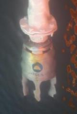
11 11 A few examples to demonstrate the concept IFREMER (French Oceanographic Research Institute) with POSIDONIA COMRA (China) with POSIDONIA & RAMSES tracking JiaoLong Manned submersible GAPS, Global Acoustic Positioning System deployable in a few minutes GAPS + INS, the solution for performance and productivity ComMet, ixblue O&G subsea metrology solution

 aimed at surveying and")


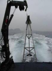
12 12 POSIDONIA II Tracking deep sea ROV in West Africa waters Who: IFREMER (Research Institute) The CONGOLOBE mission (Dec2011~Jan 2012) aimed at surveying and sampling subsea materials at the estuary of the Congo River. equipment R/V Atalante and its deep sea VICTOR ROV POSIDONIA II and FLUSH mount antenna Standard omni (192dB) transponder Five subsea location surveyed between 4,700 to 5,000m WD Performance: 0.12% x slant distance

13 13 POSIDONIA II & RAMSES acoustic tracking systems JIAOLONG manned submersible Who: COMRA, R/V Xiang Yang Hong 9 Final deep sea qualification of the vehicle and scientific experiments. equipment POSIDONIA II USBL positioning system RAMSES 6,000 low frequency synthetic Acoustic Positioning System A set of transponders on sea bed The deepest 7,000m water depth dive achieved in 2013 with JiaoLong
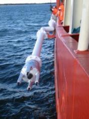
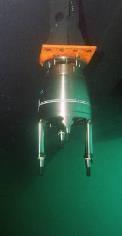


14 GAPS, the underwater positioning made simple Pre-calibrated, compact, all-in-one solution Installation cannot be simpler! (15kg in air, one cable to plug, all included) 14
 In order to save time and get immediate result from sonar surveys (with no or limited postprocessing), the addition of an INS allows usable absolute positioning and heading.")
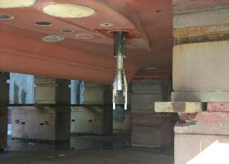
15 15 GAPS + INS on the tracked vehicle No need to post-process the navigation anymore The project Sonar data acquisition requires re-processing before the result can be considered as good enough for use (build mosaic image) In order to save time and get immediate result from sonar surveys (with no or limited postprocessing), the addition of an INS allows usable absolute positioning and heading. The performance shall be declared good with an absolute real time accuracy of 1m. Job done! Distance (m) N-S S-N W-E E-W N-S S-N W-E 0,65 0,68-0,3 E-W 0,52 0,47 0,3 -
, RAMSES (acoustics) and transponders in a ready-to-use configuration Performance better than 5cm")

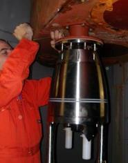
16 16 ComMet, subsea metrology (O&G) with PHINS INS and RAMSES The fastest metrology solution on the market ComMet Combines PHINS (INS), RAMSES (acoustics) and transponders in a ready-to-use configuration Performance better than 5cm Extremely redundant and safe (QA/QC) World record with 8 metrologies completed in 2 days by 1,000m WD ComMet Operated in South China Sea by SAIPEM for CNOOC on the LIWAN field. More than 80 metrologies planned, 21 jumpers already installed
17 New Underwater Positioning Solution using Underwater Acoustic and Inertial technologies Thank you for your attention
global acoustic positioning system GAPS usbl acoustic with integrated INS positioning system Ixsea Oceano GAPS page 1
 global acoustic positioning system usbl acoustic positioning system with integrated INS positioning system page 1 THE MERGER OF INERTIAL AND UNDERWATER ACOUSTIC TECHNOLOGIES is a unique Global Acoustic
PHINS, An All-In-One Sensor for DP Applications
 DYNAMIC POSITIONING CONFERENCE September 28-30, 2004 Sensors PHINS, An All-In-One Sensor for DP Applications Yves PATUREL IXSea (Marly le Roi, France) ABSTRACT DP positioning sensors are mainly GPS receivers
SUBSEA OPERATIONS SUBSEA OPERATIONS 1
 SUBSEA OPERATIONS SUBSEA OPERATIONS 1 SUBSEA OPERATIONS 2 SUBSEA OPERATIONS SUBSEA OPERATIONS 3 VISION 4 SUBSEA OPERATIONS SUBSEA OPERATIONS 5 ixblue stands as a global leader in the design and manufacturing
INS for life of field
 INS for life of field Mark Carter Business Development Manager : Inertial Oceanology 2012 Positioning Requirements Drilling Construction Pipe Lay IRM Decommissioning Rig DP (Dual Redundant) Site Survey
Survey Sensors. 18/04/2018 Danny Wake Group Surveyor i-tech Services
 Survey Sensors 18/04/2018 Danny Wake Group Surveyor i-tech Services What do we need sensors for? For pure hydrographic surveying: Depth measurements Hazard identification Seabed composition Tides & currents
Inertial Systems. Ekinox Series TACTICAL GRADE MEMS. Motion Sensing & Navigation IMU AHRS MRU INS VG
 Ekinox Series TACTICAL GRADE MEMS Inertial Systems IMU AHRS MRU INS VG ITAR Free 0.05 RMS Motion Sensing & Navigation AEROSPACE GROUND MARINE EKINOX SERIES R&D specialists usually compromise between high
Gyrocompass and motion sensor. octans. navigation and positioning
 Gyrocompass and motion sensor octans navigation and positioning the best in fog technology The technological heart of is the Fibre-Optic Gyroscope (FOG), the only truly-solid-state answer to rotation sensing.
MARINE SURVEY MARINE SURVEY 1
 MARINE SURVEY MARINE SURVEY 1 MARINE SURVEY 2 MARINE SURVEY MARINE SURVEY 3 SOLUTIONS 4 MARINE SURVEY MARINE SURVEY 5 MARINE SURVEY 5 ixblue stands as a global leader in the design and manufacturing of
Positioning Small AUVs for Deeper Water Surveys Using Inverted USBL
 Positioning Small AUVs for Deeper Water Surveys Using Inverted USBL Presented at Hydro12, Rotterdam, November 2012 Dr. T.M. Hiller, thiller@teledyne.com Overview Introduction to Gavia AUV Gavia Acoustic
Applications of iusbl Technology overview
 Applications of iusbl Technology overview Tom Bennetts Project Manager Summary 1. What is iusbl and its target applications 2. Advantages of iusbl and sample data 3. Technical hurdles and Calibration methods
Experiences with Hydrographic Data Budgets Using a Low-logistics AUV Platform. Thomas Hiller Teledyne Marine Systems
 Experiences with Hydrographic Data Budgets Using a Low-logistics AUV Platform Thomas Hiller Teledyne Marine Systems 1 Teledyne Marine Systems Strategic Business Units 2 What is the Gavia? The Gavia is
USBL positioning and communication SyStEmS. product information GUidE
 USBL positioning and communication SyStEmS product information GUidE evologics s2c R usbl - series underwater positioning and communication systems EvoLogics S2CR USBL is a series of combined positioning
LBL POSITIONING AND COMMUNICATION SYSTEMS PRODUCT INFORMATION GUIDE
 LBL POSITIONING AND COMMUNICATION SYSTEMS PRODUCT INFORMATION GUIDE EvoLogics S2C LBL Underwater Positioning and Communication Systems EvoLogics LBL systems bring the benefi ts of long baseline (LBL) acoustic
WORLD CLASS through people, technology and dedication
 WORLD CLASS through people, technology and dedication WORLD CLASS through people, technology and dedication 1 2 Acoustic Positioning Systems Hydrofest Robert Gordon University Scott Sutherland Building
WORLD CLASS through people, technology and dedication WORLD CLASS through people, technology and dedication
 WORLD CLASS through people, technology and dedication WORLD CLASS through people, technology and dedication 1 2 Acoustic Positioning Systems Hydrofest Aberdeen University Wednesday 31 st March Ian Florence
EIS - Electronics Instrumentation Systems for Marine Applications
 Coordinating unit: Teaching unit: Academic year: Degree: ECTS credits: 2015 230 - ETSETB - Barcelona School of Telecommunications Engineering 710 - EEL - Department of Electronic Engineering MASTER'S DEGREE
Acoustic INS aiding NASNet & PHINS
 NAUTRONIX MARINE TECHNOLOGY SOLUTIONS Acoustic INS aiding NASNet & PHINS Sam Hanton Aberdeen Houston Rio Positioning Options Satellites GPS, GLONASS, COMPASS Acoustics LBL, SBL, USBL Relative sensors Laser
TORSTEIN PEDERSEN. Improving the Common DVL: A New Standard in Doppler Velocity Logs
 TORSTEIN PEDERSEN Improving the Common DVL: A New Standard in Doppler Velocity Logs VOLVO OCEAN RACE 2011 Precursor to Nortek s DVL story Nortek Background for DVLs Technology Company with expertise in
Subsea Positioning In deep water
 Subsea Positioning In deep water PETRONAS - PETRAD - INTSOK CCOP DEEPWATER SUBSEA TIE-BACK Damai Puri Resort & Spa, Kuching, Sarawak, MALAYSIA 24TH - 26TH January, 2011 Supplier to the oil & gas industry
08/10/2013. Marine Positioning Systems Surface and Underwater Positioning. egm502 seafloor mapping
 egm502 seafloor mapping lecture 8 navigation and positioning Marine Positioning Systems Surface and Underwater Positioning All observations at sea need to be related to a geographical position. To precisely
USBL positioning and communication systems. Applications
 USBL positioning and communication systems Offering a powerful USBL transceiver functionality with full benefits of an S2C technology communication link Applications Positioning of offshore equipment >
Ranger USBL Acoustic Positioning System for DP Reference and Survey
 Acoustic Positioning System for DP Reference and Survey cc 545000m N 544990m 544980m 544970m 6027910m 6027900m W 6027890m 6027880m S Contents Introduction 01 Ranger USBL System Overview 02 Ranger USBL
MARKSMAN DP-INS DYNAMIC POSITIONING INERTIAL REFERENCE SYSTEM
 cc MARKSMAN DP-INS DYNAMIC POSITIONING INERTIAL REFERENCE SYSTEM Sonardyne s Marksman DP-INS is an advanced navigation-based Position Measuring Equipment (PME) source for dynamically positioned (DP) rigs.
Tsunami Detection System Nick Street, Project Engineer David Mould, Presenter.
 Tsunami Detection System Nick Street, Project Engineer David Mould, Presenter Agenda 1. Need for Tsunami Detection System 2. System Overview 3. Tsunami Detection System requirements 4. Seabed Unit - Tsunameter
Under Water Systems. Sidescan SAS image mapping for Automatic Detection and Classification
 0 Sidescan SAS image mapping for Automatic Detection and Classification Plan Sidescan SAS image mapping for ADC Sidescan Synthetic Aperture Sonar Images Interest of SAS for automatic detection and classification
Author s Name Name of the Paper Session. PDynamic. Positioning Committee. Marine Technology Society
 Author s Name Name of the Paper Session PDynamic Positioning Committee Marine Technology Society DYNAMIC POSITIONING CONFERENCE September 17-18, 2002 Acoustic Positioning Flexible Acoustic Positioning
Hydroacoustic Aided Inertial Navigation System - HAIN A New Reference for DP
 Return to Session Directory Return to Session Directory Doug Phillips Failure is an Option DYNAMIC POSITIONING CONFERENCE October 9-10, 2007 Sensors Hydroacoustic Aided Inertial Navigation System - HAIN
Teledyne Marine Oil and Gas.
 Oil and Gas www.teledynemarine.com/energy Applications in Oil and Gas Teledyne Marine encompasses over 20 brands that offer innovative, highly reliable technology spanning the life cycle of an oil field,
Construction Survey Positioning Systems Wideband Fusion LBL and USBL
 cc Construction Survey Positioning Systems Wideband Fusion LBL and USBL Contents Introduction 01 Fusion USBL 02 Fusion USBL System Specifications 05 Fusion LBL 06 Fusion LBL System Specifications 09 Precise,
PRINCIPLE OF SEISMIC SURVEY
 PRINCIPLE OF SEISMIC SURVEY MARINE INSTITUTE Galway, Ireland 29th April 2016 Laurent MATTIO Contents 2 Principle of seismic survey Objective of seismic survey Acquisition chain Wave propagation Different
A Subsea Structural Deflection Monitoring System designed by RTS AS, Norway. 51st Marine Measurement Forum Adil Ali Seatronics Limited
 A Subsea Structural Deflection Monitoring System designed by RTS AS, Norway. 51st Marine Measurement Forum Adil Ali Seatronics Limited Seatronics and RTS Seatronics Limited : Established: 1978, Aberdeen-based
Inertial Navigation System
 Apogee Marine Series ULTIMATE ACCURACY MEMS Inertial Navigation System INS MRU AHRS ITAR Free 0.005 RMS Navigation, Motion & Heave Sensing APOGEE SERIES makes high accuracy affordable for all surveying
MARINS Series. Very high performance inertial navigation system
 MARINS Series Very high performance inertial navigation system MARINS M-Series Very high-performance inertial navigation system MARINS M-Series is a family of state-of-the-art naval inertial navigation
The Oil & Gas Industry Requirements for Marine Robots of the 21st century
 The Oil & Gas Industry Requirements for Marine Robots of the 21st century www.eninorge.no Laura Gallimberti 20.06.2014 1 Outline Introduction: fast technology growth Overview underwater vehicles development
Hybrid system using both USBL and LBL for shallow waters
 OI2013 Underwater Positioning & Communication Hybrid system using both USBL and LBL for shallow waters Nicolas LARUELLE Sales Manager at OSEAN September 4th,2013 OI2013 Page 1 OVERVIEW SPECIFICATIONS PRINCIPLES
Marine Construction Support & Dimensional Control
 Page 1 of 5 Marine Construction Support & Dimensional Control Key Specifications Surface and Subsurface Positioning IRM Support Lay Support Trench Suport Installation Support Metrology As-Built Heavy Lift
MIMO Transceiver Systems on AUVs
 MIMO Transceiver Systems on AUVs Mohsen Badiey 107 Robinson Hall College of Marine and Earth Studies, phone: (302) 831-3687 fax: (302) 831-6521 email: badiey@udel.edu Aijun Song 114 Robinson Hall College
ATLANS-C. mobile mapping position and orientation solution
 mobile mapping position and orientation solution mobile mapping position and orientation solution THE SMALLEST ATLANS-C is a high performance all-in-one position and orientation solution for both land
Underwater Vehicle Systems at IFREMER. From R&D to operational systems. Jan Opderbecke IFREMER Unit for Underwater Systems
 Underwater Vehicle Systems at IFREMER From R&D to operational systems Jan Opderbecke IFREMER Unit for Underwater Systems Operational Engineering Mechanical and systems engineering Marine robotics, mapping,
Subsea positioning through the ages
 Subsea positioning through the ages Jonathan Martin Navigation Systems Engineer Sonardyne International What is sound and how can we make use of it in navigation? Applied Voltage Induced Voltage The dawn
CODEVINTEC. Miniature and accurate IMU, AHRS, INS/GNSS Attitude and Heading Reference Systems
 45 27 39.384 N 9 07 30.145 E Miniature and accurate IMU, AHRS, INS/GNSS Attitude and Heading Reference Systems Aerospace Land/Automotive Marine Subsea Miniature inertial sensors 0.1 Ellipse Series New
Teledyne Oil & Gas Innovation and Subsea Reliability
 A Member of Innovation and Subsea Reliability www.teledyneoilandgas.com Technologies A Member of Seismic Instruments Imaging Vehicles Photo Courtesy BMT has been proudly serving the oil and gas industry
MINE SEARCH MISSION PLANNING FOR HIGH DEFINITION SONAR SYSTEM - SELECTION OF SPACE IMAGING EQUIPMENT FOR A SMALL AUV DOROTA ŁUKASZEWICZ, LECH ROWIŃSKI
 MINE SEARCH MISSION PLANNING FOR HIGH DEFINITION SONAR SYSTEM - SELECTION OF SPACE IMAGING EQUIPMENT FOR A SMALL AUV DOROTA ŁUKASZEWICZ, LECH ROWIŃSKI Gdansk University of Technology Faculty of Ocean Engineering
Teledyne Marine Acoustic Imagining
 RESON SeaBat high performance sonars for long range object detection and MCM applications Navigation, object avoidance & up close inspection with BlueView Greg Probst Sales Manager, Defense Teledyne Marine
Deep. Navigating the. High Accuracy Positioning Support for Deep Water Construction. Copyright Journal of Ocean Technology 2017
 Navigating the Deep High Accuracy Positioning Support for Deep Water Construction by Will Primavesi, Tamir Frydenrych, and Drew Nicholson ISTOCKPHOTO.COM/CHERT61 The Journal of Ocean Technology, Vol. 12,
Inertial Systems. Ekinox 2 Series TACTICAL GRADE MEMS. Motion Sensing & Navigation IMU AHRS MRU INS VG
 Ekinox 2 Series TACTICAL GRADE MEMS Inertial Systems IMU AHRS MRU INS VG ITAR Free 0.02 RMS Motion Sensing & Navigation AEROSPACE GROUND MARINE EKINOX 2 SERIES R&D specialists usually compromise between
ACOUSTIC TRACKING OF AN UNMANNED UNDERWATER VEHICLE USING A PASSIVE ULTRASHORT BASELINE ARRAY AND A SINGLE LONG BASELINE BEACON. Kyle L.
 ACOUSTIC TRACKING OF AN UNMANNED UNDERWATER VEHICLE USING A PASSIVE ULTRASHORT BASELINE ARRAY AND A SINGLE LONG BASELINE BEACON by Kyle L. Seaton A Thesis Submitted to the Faculty of The College of Engineering
Author s Name Name of the Paper Session. DYNAMIC POSITIONING CONFERENCE October 8-10, 2012 SENSORS II SESSION
 Author s Name Name of the Paper Session DYNAMIC POSITIONING CONFERENCE October 8-10, 2012 SENSORS II SESSION Acoustically Aided Inertial Navigation - Proven, Robust, and Efficient, Positioning Solutions
Inertial Systems. Ekinox 2 Series TACTICAL GRADE MEMS. Motion Sensing & Navigation IMU AHRS MRU INS VG
 Ekinox 2 Series TACTICAL GRADE MEMS Inertial Systems IMU AHRS MRU INS VG ITAR Free 0.02 RMS Motion Sensing & Navigation AEROSPACE GROUND MARINE EKINOX 2 SERIES R&D specialists usually compromise between
High Precision Acoustic Positioning HiPAP
 High Precision Acoustic Positioning HiPAP www.kongsberg.com The HiPAP Family: HiPAP 501 HiPAP 451 HiPAP 351 HiPAP 351P series HiPAP 101 Maximizing performance by providing The Full Picture Our mission
Multibeam data quality assurance at Genavir. Karine Abel Michaux
 Multibeam data quality assurance at Genavir Hervé Bisquay hbisquay@genavir.fr Karine Abel Michaux kabelmic@genavir.fr Pascal Viollette pviollette@genavir.fr GENAVIR Genavir is the operator of the civilian
SIGNAL PROCESSING ALGORITHMS FOR HIGH-PRECISION NAVIGATION AND GUIDANCE FOR UNDERWATER AUTONOMOUS SENSING SYSTEMS
 SIGNAL PROCESSING ALGORITHMS FOR HIGH-PRECISION NAVIGATION AND GUIDANCE FOR UNDERWATER AUTONOMOUS SENSING SYSTEMS Daniel Doonan, Chris Utley, and Hua Lee Imaging Systems Laboratory Department of Electrical
Structure Deflection Monitoring System
 Structure Deflection Monitoring System Generation II All rights reserved. This document may be distributed within receiving entity (from RTS/Seatronics) and utilized as tender documentation. However, due
SAFE TO SEA (S2S) FOR THE SAFETY OF NAVIGTION.
 FOR THE SAFETY OF NAVIGTION.") SAFE TO SEA (S2S) FOR THE SAFETY OF NAVIGTION. GRAFINTA.S.A. Company founded in 1964 and located in Madrid. With 11 people on our payroll from which 8 are engineers specialized in new technologies and
SAFE TO SEA (S2S) FOR THE SAFETY OF NAVIGTION. GRAFINTA.S.A. Company founded in 1964 and located in Madrid. With 11 people on our payroll from which 8 are engineers specialized in new technologies and
Seafloor Mapping Using Interferometric Sonars: Advances in Technology and Techniques
 Seafloor Mapping Using Interferometric Sonars: Advances in Technology and Techniques Tom Hiller, Advanced Products Manager, GeoAcoustics Ltd. WORLD CLASS through people, technology and dedication Brest,
SeaWATCH ADCP. Self-Contained 300 khz / 600 khz / 1200 khz
 SeaWATCH ADCP Self-Contained 300 khz / 600 khz / 1200 khz The Rowe Technologies SeaWATCH product family is the most versatile self-contained Acoustic Doppler Current Profilers (ADCPs) and represent the
New GENERATION ACOUSTIC. single solution for all underwater communication needs.
 MATS 3G // New GENERATION ACOUSTIC TELEMETRY SYSTEM MATS 3G is an underwater acoustic modem that offers a single solution for all underwater communication needs. Its state-of-the-art DSP (Digital Signal
The KM3NeT acoustic positioning system. S. Viola INFN Laboratorio Nazionali del Sud - via Santa Sofia,62 - Catania, Italy
 S. Viola INFN Laboratorio Nazionali del Sud - via Santa Sofia,62 - Catania, Italy E-mail: sviola@lns.infn.it INFN Laboratorio Nazionali del Sud - via Santa Sofia,62 - Catania, Italy E-mail: coniglione@lns.infn.it
Underwater GPS User Manual
 Underwater GPS Document number W-DN-17002-2 Project Classification - Rev Prepared by Checked by Approved by Short description 1 2017-08-03 O. Skisland Initial 2 O. Skisland Minor changes References [1]
Underwater Acoustic Communication and Positioning State of the Art and New Uses
 Underwater Acoustic Communication and Positioning State of the Art and New Uses Radio signals Work only on very short distances Salty water particularly problematic No underwater GPS Cables Too heavy,
Fundamentals of Marine Technology Level 1
 The Marine Center 1701 East Front Street Level 1 Course Overview focuses on the basic understanding of systems, applications, troubleshooting, calibration and safety requirements specific to marine technology
Combined USBL and Inertial Navigation
 SENSORS Combined USBL and Inertial Navigation Mikael Bliksted Larsen Sonardyne International October 13-14, 2009 Return to Session Directory Combined USBL and Inertial Navigation - an alternative and improved
Integrity Monitoring using AUVs
 Integrity Monitoring using AUVs Andrew McMurtrie Business Development Manager NCS Survey Limited Subsea Europe, 27-28 October, in Paris Content Introduction to NCS Survey Low logistics, man-portable AUVs
Shallow Water Array Performance (SWAP): Array Element Localization and Performance Characterization
: Array Element Localization and Performance Characterization") Shallow Water Array Performance (SWAP): Array Element Localization and Performance Characterization Kent Scarbrough Advanced Technology Laboratory Applied Research Laboratories The University of Texas
Shallow Water Array Performance (SWAP): Array Element Localization and Performance Characterization Kent Scarbrough Advanced Technology Laboratory Applied Research Laboratories The University of Texas
Acoustics Digital, Spread Spectrum, DSP, Wideband What does this mean for Real World DP Operations? Jonathan Davis Sonardyne Inc
 Subsea Positioning & Communications Acoustics Digital, Spread Spectrum, DSP, Wideband What does this mean for Real World DP Operations? Jonathan Davis Sonardyne Inc Outline Introduction Signal Processing
Subsea UK 2014 Developments in ROV Technology
 Subsea UK 2014 Developments in ROV Technology Smarter Technologies Enable Smarter Platforms (ROVs) => Improved Offshore Operations Nick Lawson What does an ROV do? Any ROVs primary function is to provide
Underwater GPS User Manual
 Underwater GPS Document number W-DN-17002-3 Project Classification - Rev Prepared by Checked by Approved by Short description 1 2017-08-03 T. Trøite O. Skisland T. Trøite Initial 2 2017-08-04 T. Trøite
Inertial Navigation System
 Apogee Series ULTIMATE ACCURACY MEMS Inertial Navigation System INS MRU AHRS ITAR Free 0.005 RMS Motion Sensing & Georeferencing APOGEE SERIES makes high accuracy affordable for all surveying companies.
Autonomous Underwater Vehicles
 Autonomous Underwater Vehicles New Autonomous Underwater Vehicle technology development at WHOI to support the growing needs of scientific, commercial and military undersea search and survey operations
Side-Scan Sonar Presentation STS
 Training Module Side-Scan Sonar Presentation STS SIDE-SCAN SONAR SAFETY Training Module Content: This module includes information on: Types of Side-Scan Benefits and Disadvantages System Configuration
Cooperative navigation (part II)
") Cooperative navigation (part II) An example using foot-mounted INS and UWB-transceivers Jouni Rantakokko Aim Increased accuracy during long-term operations in GNSS-challenged environments for - First responders
Cooperative navigation (part II) An example using foot-mounted INS and UWB-transceivers Jouni Rantakokko Aim Increased accuracy during long-term operations in GNSS-challenged environments for - First responders
Eelume: The Next Evolution in Underwater Robotics. Richard Mills Director of Sales Marine Robotics Kongsberg Maritime AS
 Eelume: The Next Evolution in Underwater Robotics Richard Mills Director of Sales Marine Robotics Kongsberg Maritime AS A brief history of Marine Robotics First controlled underwater vehicle developed
Surveyors in The Oil & Gas Industry. Walter Jardine Lead Surveyor, BP North Sea Region Hydrofest 13 April 2011
 Surveyors in The Oil & Gas Industry what on earth do those guys do? Walter Jardine Lead Surveyor, BP North Sea Region Hydrofest 13 April 2011 Why Geography Matters in the O&G Industry Around 80% of the
AN AIDED NAVIGATION POST PROCESSING FILTER FOR DETAILED SEABED MAPPING UUVS
 MODELING, IDENTIFICATION AND CONTROL, 1999, VOL. 20, NO. 3, 165-175 doi: 10.4173/mic.1999.3.2 AN AIDED NAVIGATION POST PROCESSING FILTER FOR DETAILED SEABED MAPPING UUVS Kenneth Gade and Bjørn Jalving
GPS-Aided INS Datasheet Rev. 2.3
 GPS-Aided INS 1 The Inertial Labs Single and Dual Antenna GPS-Aided Inertial Navigation System INS is new generation of fully-integrated, combined L1 & L2 GPS, GLONASS, GALILEO and BEIDOU navigation and
OPT Commercialization Update
 OPT Commercialization Update Forward Looking Statements In addition to historical information, this presentation contains forward-looking statements that are within the safe harbor provisions of the Private
Robots at Work The growing role of robotic systems in the Oceans and Subsea Engineering. David Brookes Senior Advisor, Upstream Engineering, BP
 Robots at Work The growing role of robotic systems in the Oceans and Subsea Engineering David Brookes Senior Advisor, Upstream Engineering, BP Synopsis ROV s History Current Capabilities and Examples AUV
Observations of the deep-water mid-frequency ambient noise spatial structure and temporal fluctuation characteristics.
 Mid-Frequency Ambient Noise Experiment 4-21 August 2018 Objective Observations of the deep-water mid-frequency ambient noise spatial structure and temporal fluctuation characteristics. Background The 2D
From Torpedo Fire Control to Sonar at Librascope by Dave Ghen
 From Torpedo Fire Control to Sonar at Librascope by Dave Ghen Librascope made a business decision in the late 1960 s or early 1970 s to try to expand its very successful surface ship and submarine torpedo
GeoSwath Plus Wide swath bathymetry and georeferenced side scan
 GeoSwath Plus Wide swath bathymetry and georeferenced side scan www.geoacoustics.com GeoSwath Plus Wide Swath Bathymetry and co-registered georeferenced side scan system We maximise marine performance
GPS-Aided INS Datasheet Rev. 3.0
 1 GPS-Aided INS The Inertial Labs Single and Dual Antenna GPS-Aided Inertial Navigation System INS is new generation of fully-integrated, combined GPS, GLONASS, GALILEO, QZSS, BEIDOU and L-Band navigation
DP Operator Course Training Manual HPR
 - Hydroacoustic Position Reference System consists of transducer(s) onboard a vessel communicating with transponder(s) placed on the seabed. The transducers are lowered beneath the hull, and when a transponder
HiPAP HIGH PRECISION ACOUSTIC POSITIONING
 HiPAP HIGH PRECISION ACOUSTIC POSITIONING OUR MISSION We shall earn the respect and recognition for our dedication to provide innovative and reliable marine electronics that ensure optimal operation at
Advances in Subsea Integrity Monitoring Systems. Ross Macleod Business Development Director, Ashtead Technology
 Advances in Subsea Integrity Monitoring Systems Ross Macleod Business Development Director, Ashtead Technology Introduction to Ashtead Technology The market leading independent subsea sensor and ROV equipment
Acoustic Communications and Navigation for Mobile Under-Ice Sensors
 DISTRIBUTION STATEMENT A. Approved for public release; distribution is unlimited. Acoustic Communications and Navigation for Mobile Under-Ice Sensors Lee Freitag Applied Ocean Physics and Engineering 266
Pipeline Inspection and Environmental Monitoring Using AUVs
 Pipeline Inspection and Environmental Monitoring Using AUVs Bjørn Jalving, Bjørn Gjelstad, Kongsberg Maritime AUV Workshop, IRIS Biomiljø, 7 8 September 2011 WORLD CLASS through people, technology and
MULTIPATH EFFECT ON DPCA MICRONAVIGATION OF A SYNTHETIC APERTURE SONAR
 MULTIPATH EFFECT ON DPCA MICRONAVIGATION OF A SYNTHETIC APERTURE SONAR L. WANG, G. DAVIES, A. BELLETTINI AND M. PINTO SACLANT Undersea Research Centre, Viale San Bartolomeo 400, 19138 La Spezia, Italy
OFFSHORE ANALYSIS & RESEARCH SOLUTIONS HOUSTON PETROLEUM SURVEYORS GROUP PERSONNEL DATA PROCESSING PARTNERSHIPS
 OFFSHORE ANALYSIS & RESEARCH SOLUTIONS HOUSTON PETROLEUM SURVEYORS GROUP KEEPING YOUR PROJECTS IN MOTION OARS-HPSG combines the experience of two highly complementary organizations providing expanded capabilities,
Outline Use phase/channel tracking, DFE, and interference cancellation techniques in combination with physics-base time reversal for the acoustic MIMO
 High Rate Time Reversal MIMO Communications Aijun Song Mohsen nbdi Badiey University of Delaware Newark, DE 19716 University of Rhode Island, 14-1616 Oct. 2009 Outline Use phase/channel tracking, DFE,
Cooperative navigation: outline
 Positioning and Navigation in GPS-challenged Environments: Cooperative Navigation Concept Dorota A Grejner-Brzezinska, Charles K Toth, Jong-Ki Lee and Xiankun Wang Satellite Positioning and Inertial Navigation
Autonomous Underwater Vehicle Navigation.
 Autonomous Underwater Vehicle Navigation. We are aware that electromagnetic energy cannot propagate appreciable distances in the ocean except at very low frequencies. As a result, GPS-based and other such
Tightly Integrated Second Generation Acoustic-Inertial Position Reference Systems
 Return to Session Menu DYNAMIC POSITIONING CONFERENCE October 15-16, 2013 SENSORS SESSION II Tightly Integrated Second Generation Acoustic-Inertial Position Reference Systems Mark Carter Sonardyne International
SWIMMER: Hybrid AUV/ROV concept. Alain FIDANI Innovative Projects and R&D Manager Oil&Gas Division CYBERNETIX SA, France
 SWIMMER: Hybrid AUV/ROV concept Alain FIDANI Innovative Projects and R&D Manager Oil&Gas Division CYBERNETIX SA, France CONTENT OF PRESENTATION 1. SWIMMER context and concept 2. SWIMMER background information
NASNet DPR: NASNet as a Deepwater Acoustic DP Position Reference
 NAUTRONIX MARINE TECHNOLOGY SOLUTIONS NASNet DPR: NASNet as a Deepwater Acoustic DP Position Reference Aberdeen Houston Rio Overview Offshore positioning introduction Considerations of acoustic positioning
AUV Self-Localization Using a Tetrahedral Array and Passive Acoustics
 AUV Self-Localization Using a Tetrahedral Array and Passive Acoustics Nicholas R. Rypkema Erin M. Fischell Henrik Schmidt Background - Motivation Motivation: Accurate localization for miniature, low-cost
KONGSBERG seafloor-mapping echosounders
 KONGSBERG seafloor-mapping echosounders Berit Horvei WORLD CLASS through people, technology and dedication AGENDA Historical overview EM series Multibeam echosounder and Subbottom profiler Topside software.
DOWNLOAD OR READ : ADVANCES IN UNDERWATER TECHNOLOGY OCEAN SCIENCE AND OFFSHORE ENGINEERING OFFSHORE SITE INVESTIGATIO PDF EBOOK EPUB MOBI
 DOWNLOAD OR READ : ADVANCES IN UNDERWATER TECHNOLOGY OCEAN SCIENCE AND OFFSHORE ENGINEERING OFFSHORE SITE INVESTIGATIO PDF EBOOK EPUB MOBI Page 1 Page 2 investigatio advances in underwater technology pdf
Navigation Sensor Technology Aids Marine Seismic Survey
 Page 1 of 5 Navigation Sensor Technology Aids Marine Seismic Survey Al Hise, NCS SubSea; John Thorson, Sparton Navigation and Exploration; Craig Lippus, Geometrics April 1, 2012 A new digital compass provides
ROV TRAINING & SUBSEA SOLUTIONS.
 ROV TRAINING & SUBSEA SOLUTIONS www.qstar.es www.rovs.eu The Company The company THE COMPANY Founded in 2007, QSTAR - ROV TRAINING & SUBSEA SOLUTIONS, located in the Canary Islands & Barcelona (Spain)
Underwater acoustics Measurement of radiated underwater sound from percussive pile driving
 INTERNATIONAL STANDARD ISO 18406 First edition 2017-04 Underwater acoustics Measurement of radiated underwater sound from percussive pile driving Acoustique sous-marine Mesurage du son sous-marin émis