Assessment of instrument STability and Retrieval Algorithms for SMOS data (ASTRA)
|
|
|
- Laureen Singleton
- 5 years ago
- Views:
Transcription
1 Assessment of instrument STability and Retrieval Algorithms for SMOS data (ASTRA) S.Paloscia IFAC-CNR MRSG - Microwave Remote Sensing Group Florence (Italy) Microwave Remote Sensing Group
2 I - DOMEX-2 : long time stability of L-band emission at Dome-C Antarctica Giovanni Macelloni, Marco Brogioni, Simonetta Paloscia, Simone Pettinato (CNR-IFAC) Mark Drinkwater (ESA/ESTEC) Andrea Crepaz (CVA-ARPAV)
3 Objectives Verify the use of the East Antarctic plateau as an extended target for calibrating and monitoring the performances of SMOS: Evaluation of the long-time stability of L-band microwave emission by using ground data collected at Concordia station in (Domex-2) and comparison with the results obtained during Domex-1 ( ) Evaluation of spatial stability of microwave emission by using active and passive satellite data
4 Dome C: Location CSA Dome C The site is view on a sub-daily frequency by polar-orbiting satellites, at a variety of incidence and azimuth angles. Homogeneity of snow surface at the 100 km scale. Small surface roughness relative to other ice sheets. Low snow accumulation rate (around 3.7cm/yr). Clear sky, and extremely dry and stable atmosphere. Well known topography and environmental condition Concordia Station (Dome C): S, E 3270 a.s.l
5 Expected L-band stability Tbv Annual Variation (K) L Amsre-2005 SMMR-SSM/I C X Frequency (GHz) Ku Ka Extrapolation to L-band indicates average seasonal amplitude << 1 K C-band suggests that DC T b s are sufficiently stable to identify drifts in SMOS calibration But experiments needed to verify annual L-band stability
6 SMOS coverage at Dome-C Typically 2-7 overlapping passes/day N Azimuth variation Dome C 75S 125E numerous overpasses per day distributed in incidence, azimuth N Incidence variation Dome C 75S 125E Azymuth (deg) Incidence (deg)
7 DOMEX-2 Preparation L-band radiometer : New antenna Potter Horn New thermal system : 1 year experiment in extreme environmental conditions Temp = -80 C / -15 C thermal stability Minimize sun effect (during summer) Radiometer Tests and Calibration

8 The Instrument IR radiometer 180 cm 70 cm Actuator RaDomeX - Radiometer Frequency : 1413 MHz Bandwidth: 27 MHz Sensitivity = 0.2 K (Ti =2 sec) Polarization: H and V Antenna: Potter Antenna HPBW: 20 L- Band Potter Antenna

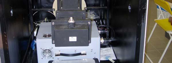


9 The Instrument Antenna : Potter horn IR -radiom 180 cm OMT Radiometer 70 cm PC

10 Thermal Tests THERMAL CHAMBER -25 /-65 C Diurnal Cycle IR Lamps solar effect ESA TEC model and design
11 Thermal test results : OMT 12 External Temperature Variation = Negligible Internal Temperature Variation


12 Radiometer Calibration Lake and Sky Measurements Anechoic Chamber
13 Radiometer Calibration Theoretical Tb (K) Tv y = x R 2 = Theoretical Tb (K) y = x R2 = Th Measured Tb (K) Measured Tb (K)
14 Domex-2 Experiment An experimental campaign (DOMEX-2) with ground based radiometers started at Concordia Base in Austral Summer 2008 to check the stability of L band emission at yearly scale, within the framework of the ESA-SMOS calibration and validation activities Snow measurements (including ice core) were carried out during the summer campaign in order to characterize physical snow properties of the first 10 meters. These data will be used as inputs to a multilayer electromagnetic model able to simulate Tb

15 The DOMEX Campaign TOWER VIEW Concordia base Air temperature Mean: - 53 degs Max: - 23 degs Min: - 78 degs
16 Tower Installation RADOMEX support RADOMEX

17 Tower Installation 15 m
18 DOMEX-2 Schedule Start : 29 November 2008 End: November 2009 (TBC) Data Transfer : Tower Base Italy (1 day) Measurements cycle: LAN 140 Incidence Angle (degs) ICE SHEET Sky (calib.) Time (min.) SMOS Fixed Angle 42
19 Complementary Snow measurements Summer Snow deposition: Grains shape and Size Classification (precipitation, hoar, wind, etc.) Winter Snow layers: Temperature Hardness Density Grains shape and Size Dielectric Constant
20 Domex-2 Preliminary results Brightness Temperature (K) Not calibrated data Tv Th Theta Tv Th Theta SNOW SKY SNOW (Fix. Ang.) Time (sec.) Incidence angle (degs)
21 Domex-2 Preliminary results Instrument Temperature Monitoring Temperature (degs.) RF components Cables and connectors Time (min.) DAILY Fluctuations < 1.5 C as expected by ESA-TEC model
22 DOMEX-2 Temporal Stability Tb - Vertical Pol (K) January / March Comparison January = blue March = pink Time (min.) Not calibrated & not temperature corrected TB differences < 1 K
23 DOMEX-2 Status and Summary The instrument has been developed and successfully tested in Italy The instrument has been installed at Concordia base Experiment started at the end of November and is now in progress Thermal stability of the instrument is confirmed (as predicted by the ESA-TEC model) First results are promising Absolute calibration will be considered in the next months (temperature correction and deconvolution effect) Satellite data analysis (spatial variability) is in progress
L-band brightness temperature at Dome-C Antarctica: intercomparison between DOMEX-3, SMOS and Aquarius data
 SMOS & AQUARIUS SCIENCE WORKSHOP Brest 15 17 April 2013 L-band brightness temperature at Dome-C Antarctica: intercomparison between DOMEX-3, SMOS and Aquarius data Marco Brogioni, Giovanni Macelloni, Simone
GNSS-R for studies of the cryosphere
 GNSS-R for studies of the cryosphere F. Fabra 1, E. Cardellach 1, O. Nogués-Correig 1, S. Oliveras 1, S. Ribó 1, J.C. Arco 1, A. Rius 1, M. Belmonte-Rivas 2, M. Semmling 3, G. Macelloni 4, S. Pettinato
Passive Microwave Sensors LIDAR Remote Sensing Laser Altimetry. 28 April 2003
 Passive Microwave Sensors LIDAR Remote Sensing Laser Altimetry 28 April 2003 Outline Passive Microwave Radiometry Rayleigh-Jeans approximation Brightness temperature Emissivity and dielectric constant
Microwave Radiometry Laboratory Experiment
 Microwave Radiometry Laboratory Experiment JEFFREY D. DUDA Iowa State University Department of Geologic and Atmospheric Sciences ABSTRACT A laboratory experiment involving the use of a microwave radiometer
Dual Polarized Radiometers DPR Series RPG DPR XXX. Applications. Features
 Dual Polarized Radiometers Applications Soil moisture measurements Rain observations Discrimination of Cloud Liquid (LWC) and Rain Liquid (LWR) Accurate LWP measurements during rain events Cloud physics
The SMOS Field Campaigns Status report on 10 May 2006
 Page 1/22 The SMOS Field Campaigns Status report on 10 May 2006 Patrick Wursteisen Presentation structure Page 2/22 Earlier campaigns for initial work on SMOS: WISE experiments at Oil Platform near Barcelona
GNSS-R for Ocean and Cryosphere Applications
 GNSS-R for Ocean and Cryosphere Applications E.Cardellach and A. Rius Institut de Ciències de l'espai (ICE/IEEC-CSIC), Spain Contents Altimetry with Global Navigation Satellite Systems: Model correlation
Advanced Radiometer for Sea Surface Temperature Observations
 Advanced Radiometer for Sea Surface Temperature Observations Harp Technologies Oy: J. Kainulainen, J. Uusitalo, J. Lahtinen TERMA A/S: M. Hansen, M. Pedersen Finnish Remote Sensing Days 2014 Finnish Meteorological
Are Radiometers and Scatterometers Seeing the Same Wind Speed?
 Are Radiometers and Scatterometers Seeing the Same Wind Speed? Frank J. Wentz and Thomas Meissner Remote Sensing Systems NASA Ocean Vector Wind Science Team Meeting May 18-, 9 Boulder, CO Radiometer and
RPG-MWR-PRO-TN Page 1 / 12 Radiometer Physics GmbH
 Applications Tropospheric profiling of temperature, humidity and liquid water High-resolution boundary layer temperature profiles, better resolution than balloons Input for weather and climate models (data
Sea surface temperature observation through clouds by the Advanced Microwave Scanning Radiometer 2
 Sea surface temperature observation through clouds by the Advanced Microwave Scanning Radiometer 2 Akira Shibata Remote Sensing Technology Center of Japan (RESTEC) Tsukuba-Mitsui blds. 18F, 1-6-1 Takezono,
GNSS-R for Land Bio-Geophysical Parameters Monitoring: the LEiMON Project
 GNSS-R for Land Bio-Geophysical Parameters Monitoring: the LEiMON Project Alejandro Egido(1), Marco Caparrini(1), Leila Guerriero(2), Nazzareno Pierdicca(2), Simonetta Paloscia(3), Marco Brogioni(3), Nicolas
Forest Fire Detection by Low-Cost 13GHz Radiometer
 Forest Fire Detection by Low-Cost 13GHz Radiometer F. Alimenti, S. Bonafoni, G. Tasselli, S. Leone, L. Roselli, K. Solbach, P. Basili 1 Summary Introduction Principle of operation Sensor architecture Radiometer
Aquarius/SAC-D and Soil Moisture
 Aquarius/SAC-D and Soil Moisture T. J. Jackson P. O Neill February 24, 2011 Aquarius/SAC-D and Soil Moisture + L-band dual polarization + Combined active and passive Coarse spatial resolution (~100 km)
EVLA System Commissioning Results
 EVLA System Commissioning Results EVLA Advisory Committee Meeting, March 19-20, 2009 Rick Perley EVLA Project Scientist t 1 Project Requirements EVLA Project Book, Chapter 2, contains the EVLA Project
 ENVISAT Microwave Radiometer Assessment Report Cycle 051 04-09-2006 09-10-2006 Prepared by : M. DEDIEU, CETP L. EYMARD, LOCEAN/IPSL E. OBLIGIS, CLS OZ. ZANIFE, CLS F. FERREIRA, CLS Checked by : Approved
Environmental Data Records from Special Sensor Microwave Imager and Sounder (SSMIS)
") Environmental Data Records from Special Sensor Microwave Imager and Sounder (SSMIS Fuzhong Weng Center for Satellite Applications and Research National Environmental, Satellites, Data and Information Service
Environmental Data Records from Special Sensor Microwave Imager and Sounder (SSMIS Fuzhong Weng Center for Satellite Applications and Research National Environmental, Satellites, Data and Information Service
ENVISAT/MWR : 36.5 GHz Channel Drift Status
 CLS.DOS/NT/03.695 Issue : 1rev1 Ramonville, 10 March 2003 Nomenclature : - : 36.5 GHz Channel Drift Status PREPARED BY M. Dedieu L. Eymard C. Marimont E. Obligis N. Tran COMPANY DATE INITIALS CETP CETP
Microwave Sensors Subgroup (MSSG) Report
 Report") Microwave Sensors Subgroup (MSSG) Report Feb 17-20, 2014, ESA ESRIN, Frascati, Italy DONG, Xiaolong, MSSG Chair National Space Science Center Chinese Academy of Sciences (MiRS,NSSC,CAS) Email: dongxiaolong@mirslab.cn
Microwave Sensors Subgroup (MSSG) Report Feb 17-20, 2014, ESA ESRIN, Frascati, Italy DONG, Xiaolong, MSSG Chair National Space Science Center Chinese Academy of Sciences (MiRS,NSSC,CAS) Email: dongxiaolong@mirslab.cn
Aquarius/SAC-D Mission Mission Simulators - Gary Lagerloef 6 th Science Meeting; Seattle, WA, USA July 2010
 Aquarius/SAC-D Mission Mission Simulators - Gary Lagerloef 6 th Science Meeting; Seattle, WA, USA Mission Design and Sampling Strategy Sun-synchronous exact repeat orbit 6pm ascending node Altitude 657
Simulation study for the Stratospheric Inferred Wind (SIW) sub-millimeter limb sounder
 sub-millimeter limb sounder") Simulation study for the Stratospheric Inferred Wind (SIW) sub-millimeter limb sounder Philippe Baron1, Donal Murtagh2 (PI), Patrick Eriksson2, Kristell Pérot2 and Satoshi Ochiai1 (1) National Institute
Simulation study for the Stratospheric Inferred Wind (SIW) sub-millimeter limb sounder Philippe Baron1, Donal Murtagh2 (PI), Patrick Eriksson2, Kristell Pérot2 and Satoshi Ochiai1 (1) National Institute
 ENVISAT Microwave Radiometer Assessment Report Cycle 045 07-02-2006 13-03-2006 Prepared by : M. DEDIEU, CETP L. EYMARD, LOCEAN/IPSL E. OBLIGIS, CLS OZ. ZANIFE, CLS F. FERREIRA, CLS Checked by : Approved
Soil moisture retrieval using ALOS PALSAR
 Soil moisture retrieval using ALOS PALSAR T. J. Jackson, R. Bindlish and M. Cosh USDA ARS Hydrology and Remote Sensing Lab, Beltsville, MD J. Shi University of California Santa Barbara, CA November 6,
Spacecraft Communications
 Antennas Orbits Modulation Noise Link Budgets 1 2012 David L. Akin - All rights reserved http://spacecraft.ssl.umd.edu The Problem Pointing Loss Polarization Loss Atmospheric Loss, Rain Loss Space Loss
A Climate Record of Enhanced Spatial Resolution Microwave Radiometer Data
 A Climate Record of Enhanced Spatial Resolution Microwave Radiometer Data D. G. Long*, A. Paget*, and M. J. Brodzik * Brigham Young University National Snow and Ice Data Center Earth observing Passive
Lecture Notes Prepared by Prof. J. Francis Spring Remote Sensing Instruments
 Lecture Notes Prepared by Prof. J. Francis Spring 2005 Remote Sensing Instruments Material from Remote Sensing Instrumentation in Weather Satellites: Systems, Data, and Environmental Applications by Rao,
AGRON / E E / MTEOR 518 Laboratory
 AGRON / E E / MTEOR 518 Laboratory Brian Hornbuckle, Nolan Jessen, and John Basart April 5, 2018 1 Objectives In this laboratory you will: 1. identify the main components of a ground based microwave radiometer
An intercomparison of SMAP, SMOS, AMSR2, FY3B and ESA CCI soil moisture products at different spatial scales over two dense network regions
 An intercomparison of SMAP, SMOS, AMSR2, FY3B and ESA CCI soil moisture products at different spatial scales over two dense network regions Jiangyuan Zeng 1, Kun-Shan Chen 1, Chenyang Cui 2, Haiyun Bi
MODULE 9 LECTURE NOTES 1 PASSIVE MICROWAVE REMOTE SENSING
 MODULE 9 LECTURE NOTES 1 PASSIVE MICROWAVE REMOTE SENSING 1. Introduction The microwave portion of the electromagnetic spectrum involves wavelengths within a range of 1 mm to 1 m. Microwaves possess all
Earth Exploration-Satellite Service (EESS) - Passive Spaceborne Remote Sensing
 - Passive Spaceborne Remote Sensing") Earth Exploration-Satellite Service (EESS) - Passive Spaceborne Remote Sensing John Zuzek Vice-Chairman ITU-R Study Group 7 ITU/WMO Seminar on Spectrum & Meteorology Geneva, Switzerland 16-17 September
Earth Exploration-Satellite Service (EESS) - Passive Spaceborne Remote Sensing John Zuzek Vice-Chairman ITU-R Study Group 7 ITU/WMO Seminar on Spectrum & Meteorology Geneva, Switzerland 16-17 September
ERS2 Microwave Radiometer Assessment Report. Cycle L. EYMARD, CETP C. MARIMONT, CETP E. OBLIGIS, CLS N.
 ERS2 Microwave Radiometer Assessment Report Cycle 084 29-04-2003 02-06-2003 Prepared by : M. DEDIEU, CETP L. EYMARD, CETP C. MARIMONT, CETP E. OBLIGIS, CLS N. TRAN, CLS Checked by : Approved by : L. EYMARD,
Description of the Instruments and Algorithm Approach
 Description of the Instruments and Algorithm Approach Passive and Active Remote Sensing SMAP uses active and passive sensors to measure soil moisture National Aeronautics and Space Administration Applied
RPG-HATPRO-G5 series High-precision microwave radiometers for continuous atmospheric profi ling
 High-precision microwave radiometers for continuous atmospheric profi ling Applications Tropospheric Profiling of temperature, humidity, and liquid water Water Vapour Monitoring e.g. at astronomical sites
THE MICROWAVE RADIOMETER PAYLOAD
 University of L Aquila and University La Sapienza of Rome THE MICROWAVE RADIOMETER PAYLOAD 9th ILEWG International Conference on Exploration and Utilisation of the Moon (ICEUM9/ILC007) -6 October, 007,
Prototype Software-based Receiver for Remote Sensing using Reflected GPS Signals. Dinesh Manandhar The University of Tokyo
 Prototype Software-based Receiver for Remote Sensing using Reflected GPS Signals Dinesh Manandhar The University of Tokyo dinesh@qzss.org 1 Contents Background Remote Sensing Capability System Architecture
Design and Development of a Ground-based Microwave Radiometer System
 PIERS ONLINE, VOL. 6, NO. 1, 2010 66 Design and Development of a Ground-based Microwave Radiometer System Yu Zhang 1, 2, Jieying He 1, 2, and Shengwei Zhang 1 1 Center for Space Science and Applied Research,
Antennas Orbits Modulation Noise Link Budgets U N I V E R S I T Y O F. Spacecraft Communications MARYLAND. Principles of Space Systems Design
 Antennas Orbits Modulation Noise Link Budgets The Problem Pointing Loss Polarization Loss Atmospheric Loss, Rain Loss Space Loss Pointing Loss Transmitter Antenna SPACE CHANNEL Receiver Power Amplifier
The Global Imager (GLI)
") The Global Imager (GLI) Launch : Dec.14, 2002 Initial check out : to Apr.14, 2003 (~L+4) First image: Jan.25, 2003 Second image: Feb.6 and 7, 2003 Calibration and validation : to Dec.14, 2003(~L+4) for
The Global Imager (GLI) Launch : Dec.14, 2002 Initial check out : to Apr.14, 2003 (~L+4) First image: Jan.25, 2003 Second image: Feb.6 and 7, 2003 Calibration and validation : to Dec.14, 2003(~L+4) for
Microwave Sensors Subgroup (MSSG) Report
 Report") Microwave Sensors Subgroup (MSSG) Report CEOS WGCV-35 May 13-17, 2013, Shanghai, China DONG, Xiaolong, MSSG Chair CAS Key Laboratory of Microwave Remote Sensing National Space Science Center Chinese Academy
Microwave Sensors Subgroup (MSSG) Report CEOS WGCV-35 May 13-17, 2013, Shanghai, China DONG, Xiaolong, MSSG Chair CAS Key Laboratory of Microwave Remote Sensing National Space Science Center Chinese Academy
Sources classification
 Sources classification Radiometry relates to the measurement of the energy radiated by one or more sources in any region of the electromagnetic spectrum. As an antenna, a source, whose largest dimension
Remote Sensing 1 Principles of visible and radar remote sensing & sensors
 Remote Sensing 1 Principles of visible and radar remote sensing & sensors Nick Barrand School of Geography, Earth & Environmental Sciences University of Birmingham, UK Field glaciologist collecting data
WIESON TECHNOLOGIES CO., LTD.
 WIESON 3D CHAMBER TEST REPORT G121HT632-1 Page 1 of 2 I. Summary: This report to account for the measurement setup and result of the Antenna. The measurement setup includes s-parameter, pattern, and gain
Low-cost water vapour radiometry
 Low-cost water vapour radiometry Prospects and progress Tinus Stander, Pr.Eng, PhD, SMIEEE Hilo, 13 June 2017 Agenda Introduction to CEFIM mm-wave group Project Context An engineer s view of WVR Current
GPS Active Antenna With GPRS Measurement Report
 GPS Active Antenna With GPRS Measurement Report Summary: This report is to account for the measurement setup and results of 4x23mm and mm height GPS active antenna combined with GPRS antenna measurement.
WindSat L2A Product Specification Document
 WindSat L2A Product Specification Document Kyle Hilburn Remote Sensing Systems 30-May-2014 1. Introduction Purpose of this document is to describe the data provided in Remote Sensing Systems (RSS) L2A
A Climate Record of Enhanced Spatial Resolution Radiometer Data
 Scatterometer Climate Record Pathfinder BYU Center for Remote Sensing Microwave Earth Remote Sensing Laboratory (MERS) A Climate Record of Enhanced Spatial Resolution Radiometer Data Aaron C Paget, David
Topic 7: PASSIVE MICROWAVE SYSTEMS
 CEE 6100 / CSS 6600 Remote Sensing Fundamentals 1 Topic 7: PASSIVE MICROWAVE SYSTEMS GOALS: At the end of this Section you should be able to: 1. Define the effective wavelength range of microwave systems,
Introduction Active microwave Radar
 RADAR Imaging Introduction 2 Introduction Active microwave Radar Passive remote sensing systems record electromagnetic energy that was reflected or emitted from the surface of the Earth. There are also
Chapter 7 HF Propagation. Ionosphere Solar Effects Scatter and NVIS
 Chapter 7 HF Propagation Ionosphere Solar Effects Scatter and NVIS Ionosphere and Layers Radio Waves Bent by the Ionosphere Daily variation of Ionosphere Layers Ionospheric Reflection Conduction by electrons
The Biomass Mission, status of the satellite system
 The Biomass Mission, status of the satellite system M. Arcioni, P. Bensi, M. Fehringer, F. Fois, F. Heliere, K. Scipal PolInSAR/Biomass Meeting 2015, ESRIN 29/01/2015 1. Key facts (lifetime, duty cycle
SATELLITE OCEANOGRAPHY
 SATELLITE OCEANOGRAPHY An Introduction for Oceanographers and Remote-sensing Scientists I. S. Robinson Lecturer in Physical Oceanography Department of Oceanography University of Southampton JOHN WILEY
and Spectrum Protection
 Earth Remote Sensing and Spectrum Protection Steven C. Reising Microwave Systems Laboratory Colorado State University Steven.Reising@ColoState.edu Jff Jeffrey R. Piepmeieri NASA s Goddard Space Flight
Active and Passive Microwave Remote Sensing
 Active and Passive Microwave Remote Sensing Passive remote sensing system record EMR that was reflected (e.g., blue, green, red, and near IR) or emitted (e.g., thermal IR) from the surface of the Earth.
RECOMMENDATION ITU-R SM * Measuring of low-level emissions from space stations at monitoring earth stations using noise reduction techniques
 Rec. ITU-R SM.1681-0 1 RECOMMENDATION ITU-R SM.1681-0 * Measuring of low-level emissions from space stations at monitoring earth stations using noise reduction techniques (2004) Scope In view to protect
Theoretical Simulations of GNSS Reflections from Bare and Vegetated Soils
 Theoretical Simulations of GNSS Reflections from Bare and Vegetated Soils R. Giusto 1, L. Guerriero, S. Paloscia 3, N. Pierdicca 1, A. Egido 4, N. Floury 5 1 DIET - Sapienza Univ. of Rome, Rome DISP -
CHARACTERIZATION OF PHASE SHIFTERS ON A KU-BAND PHASED ARRAY ANTENNA ESA/ESTEC, NOORDWIJK, THE NETHERLANDS 3-5 OCTOBER 2012
 CHARACTERIZATION OF PHASE SHIFTERS ON A KU-BAND PHASED ARRAY ANTENNA ESA/ESTEC, NOORDWIJK, THE NETHERLANDS 3-5 OCTOBER 2012 J. Arendt (1), R. Wansch (1), H. Frühauf (1) (1) Fraunhofer IIS, Am Wolfsmantel
GMES Sentinel-1 Transponder Development
 GMES Sentinel-1 Transponder Development Paul Snoeij Evert Attema Björn Rommen Nicolas Floury Malcolm Davidson ESA/ESTEC, European Space Agency, Noordwijk, The Netherlands Outline 1. GMES Sentinel-1 overview
RECOMMENDATION ITU-R S.733-1* (Question ITU-R 42/4 (1990))**
)**") Rec. ITU-R S.733-1 1 RECOMMENDATION ITU-R S.733-1* DETERMINATION OF THE G/T RATIO FOR EARTH STATIONS OPERATING IN THE FIXED-SATELLITE SERVICE (Question ITU-R 42/4 (1990))** Rec. ITU-R S.733-1 (1992-1993)
Rec. ITU-R S.733-1 1 RECOMMENDATION ITU-R S.733-1* DETERMINATION OF THE G/T RATIO FOR EARTH STATIONS OPERATING IN THE FIXED-SATELLITE SERVICE (Question ITU-R 42/4 (1990))** Rec. ITU-R S.733-1 (1992-1993)
4GHz / 6GHz Radiation Measurement System
 4GHz / 6GHz Radiation Measurement System The MegiQ Radiation Measurement System (RMS) is a compact test system that performs 3-axis radiation pattern measurement in non-anechoic spaces. With a frequency
Improvement of Antenna System of Interferometric Microwave Imager on WCOM
 Progress In Electromagnetics Research M, Vol. 70, 33 40, 2018 Improvement of Antenna System of Interferometric Microwave Imager on WCOM Aili Zhang 1, 2, Hao Liu 1, *,XueChen 1, Lijie Niu 1, Cheng Zhang
Microwave Remote Sensing (1)
") Microwave Remote Sensing (1) Microwave sensing encompasses both active and passive forms of remote sensing. The microwave portion of the spectrum covers the range from approximately 1cm to 1m in wavelength.
Microwave Remote Sensing (1) Microwave sensing encompasses both active and passive forms of remote sensing. The microwave portion of the spectrum covers the range from approximately 1cm to 1m in wavelength.
Remote sensing radio applications/ systems for environmental monitoring
 Remote sensing radio applications/ systems for environmental monitoring Alexandre VASSILIEV ITU Radiocommunication Bureau phone: +41 22 7305924 e-mail: alexandre.vassiliev@itu.int 1 Source: European Space
Current and Future Meteorological Satellite Program of China
 Current and Future Meteorological Satellite Program of China ZHANG Wenjian, DONG Chaohua XU Jianmin, YANG Jun China Meteorological Administration May 30, 2005 Beijing, CHINA Outline of the Presentation
Table 9-1 Operating characteristics of upper-air meteorological monitoring systems. BOUNDARY LAYER VARIABLES RADIOSONDE DOPPLER SODAR
 Table 9-1 VARIABLES p, T, RH Vector winds (WS, WD) Vector winds (WS, WD) Virtual temperature (T v ) Measured Vector winds (WS, WD) u,v,w wind components u,v,w wind components w wind component Altitude
Implementation of the Instrument Only Correction
 Implementation of the Instrument Only Correction Sidharth Misra and Shannon Brown Jet Propulsion Laboratory, California Institute of Technology 03/29/2016 Copyright 2016 California Institute of Technology
Introduction to Radar
 National Aeronautics and Space Administration ARSET Applied Remote Sensing Training http://arset.gsfc.nasa.gov @NASAARSET Introduction to Radar Jul. 16, 2016 www.nasa.gov Objective The objective of this
More Radio Astronomy
 More Radio Astronomy Radio Telescopes - Basic Design A radio telescope is composed of: - a radio reflector (the dish) - an antenna referred to as the feed on to which the radiation is focused - a radio
Earth Observation and Sensing Technologies: a focus on Radar Imaging Developments. Riccardo Lanari
 Earth Observation and Sensing Technologies: a focus on Radar Imaging Developments Riccardo Lanari Institute for Electromagnetic Sensing of the Environment (IREA) National Research Council of Italy (CNR)
Receiver Design for Passive Millimeter Wave (PMMW) Imaging
 Imaging") Introduction Receiver Design for Passive Millimeter Wave (PMMW) Imaging Millimeter Wave Systems, LLC Passive Millimeter Wave (PMMW) sensors are used for remote sensing and security applications. They rely
Introduction Receiver Design for Passive Millimeter Wave (PMMW) Imaging Millimeter Wave Systems, LLC Passive Millimeter Wave (PMMW) sensors are used for remote sensing and security applications. They rely
Sub-Mesoscale Imaging of the Ionosphere with SMAP
 Sub-Mesoscale Imaging of the Ionosphere with SMAP Tony Freeman Xiaoqing Pi Xiaoyan Zhou CEOS Workshop, ASF, Fairbanks, Alaska, December 2009 1 Soil Moisture Active-Passive (SMAP) Overview Baseline Mission
Mobile System for Remote Sensing of Wind, Humidity, Temperature and Precipitation Microstructure Profiles during Special Events and Sport Competitions
 Mobile System for Remote Sensing of Wind, Humidity, Temperature and Precipitation Microstructure Profiles during Special Events and Sport Competitions Introduction By Alexander Gusev, Viktor Ignatov, Arkadiy
Test specification: Section (e)(1), Radiated emissions below 40 GHz Test procedure: ANSI C63.4, Sections 8.3.2, 13.2, 13.4 Test mode: Compliance
(1), Radiated emissions below 40 GHz Test procedure: ANSI C63.4, Sections 8.3.2, 13.2, 13.4 Test mode: Compliance") Test specification: Section 15.253(e)(1), Radiated emissions below 40 GHz Test procedure: ANSI C63.4, Sections 8.3.2, 13.2, 13.4 Plot 7.2.7 Radiated emission measurements at frequency 7280 MHz Low channel
Test specification: Section 15.253(e)(1), Radiated emissions below 40 GHz Test procedure: ANSI C63.4, Sections 8.3.2, 13.2, 13.4 Plot 7.2.7 Radiated emission measurements at frequency 7280 MHz Low channel
Signal Flow & Radiometer Equation. Aletha de Witt AVN-Newton Fund/DARA 2018 Observational & Technical Training HartRAO
 Signal Flow & Radiometer Equation Aletha de Witt AVN-Newton Fund/DARA 2018 Observational & Technical Training HartRAO Understanding Radio Waves The meaning of radio waves How radio waves are created -
Calibration Concepts for Future Low Frequency SAR Systems. Jens Reimann, Marco Schwerdt, Sravan Kumar Aitha and Manfred Zink
 Calibration Concepts for Future Low Frequency SAR Systems Jens Reimann, Marco Schwerdt, Sravan Kumar Aitha and Manfred Zink DLR.de Chart 2 Low Frequency SAR Missions OHB DLR.de Chart 3 BIOMASS - Facts
Outlines. Attenuation due to Atmospheric Gases Rain attenuation Depolarization Scintillations Effect. Introduction
 PROPAGATION EFFECTS Outlines 2 Introduction Attenuation due to Atmospheric Gases Rain attenuation Depolarization Scintillations Effect 27-Nov-16 Networks and Communication Department Loss statistics encountered
ALOS and PALSAR. Masanobu Shimada
 ALOS and PALSAR Masanobu Shimada Earth Observation Research Center, National Space Development Agency of Japan, Harumi 1-8-10, Harumi island triton square office tower X 22, Chuo-Ku, Tokyo-To, Japan, 104-6023,
Algorithm Development GCOM-W AMSR-2 Ocean Product Suite
 Algorithm Development GCOM-W AMSR-2 Ocean Product Suite Joint PI Workshop of Global Environment Observation Mission Otemachi, Tokyo, Japan December 6-9, 2010 Chelle Gentemann Marty Brewer Kyle Hilburn
A Method for Gain over Temperature Measurements Using Two Hot Noise Sources
 A Method for Gain over Temperature Measurements Using Two Hot Noise Sources Vince Rodriguez and Charles Osborne MI Technologies: Suwanee, 30024 GA, USA vrodriguez@mitechnologies.com Abstract P Gain over
AGRON / E E / MTEOR 518: Microwave Remote Sensing
 AGRON / E E / MTEOR 518: Microwave Remote Sensing Dr. Brian K. Hornbuckle, Associate Professor Departments of Agronomy, ECpE, and GeAT bkh@iastate.edu What is remote sensing? Remote sensing: the acquisition
Characterization of GOCE GPS Antennas
 Characterization of GOCE GPS Antennas Florian Dilßner, Günter Seeber (IfE), Universität Hannover, Germany Martin Schmitz, Gerhard Wübbena Geo++ GmbH, Garbsen, Germany Giovanni Toso, Damien Maeusli European
Outline. GPS RO Overview. COSMIC Overview. COSMIC-2 Overview. Summary 9/29/16
 Bill Schreiner and UCAR/COSMIC Team UCAR COSMIC Program Observation and Analysis Opportunities Collaborating with the ICON and GOLD Missions Sept 27, 216 GPS RO Overview Outline COSMIC Overview COSMIC-2
9 Moisture Monitoring
 9 Moisture Monitoring Microwave techniques have been considered for moisture sensing in many food processing and agriculture-related industries (Trabelsi, et al. 1998b). Chapter 7 highlighted the strong
Radio Frequency Interference Characterization and Detection in L-band Microwave Radiometry DISSERTATION
 Radio Frequency Interference Characterization and Detection in L-band Microwave Radiometry DISSERTATION Presented in Partial Fulfillment of the Requirements for the Degree Doctor of Philosophy in the Graduate
PASSIVE MICROWAVE PROTECTION: IMPACT OF RFI INTERFERENCE ON SATELLITE PASSIVE OBSERVATIONS
 PASSIVE MICROWAVE PROTECTION: IMPACT OF RFI INTERFERENCE ON SATELLITE PASSIVE OBSERVATIONS Jean PLA CNES, Toulouse, France Frequency manager 1 Description of the agenda items 1.2 and 1.20 for the next
Dave McGinnis Rich Kelley Jean Pla NESDIS spectrum manager Alion Science CNES Silver Spring, MD Suitland, MD Toulouse, FR
 Dave McGinnis Rich Kelley Jean Pla NESDIS spectrum manager Alion Science CNES Silver Spring, MD 20910 Suitland, MD 20746 Toulouse, FR New ITU R report Identification of degradation due to interference
Microwave Remote Sensing
 Provide copy on a CD of the UCAR multi-media tutorial to all in class. Assign Ch-7 and Ch-9 (for two weeks) as reading material for this class. HW#4 (Due in two weeks) Problems 1,2,3 and 4 (Chapter 7)
Thomas Meissner, Frank Wentz, Kyle Hilburn Remote Sensing Systems
 Thomas Meissner, Frank Wentz, Kyle Hilburn Remote Sensing Systems meissner@remss.com presented at the 8th Aquarius/SAC-D Science Team Meeting November 12-14, 2013 Buenos Aires, Argentina 1. Improved Surface
EE 529 Remote Sensing Techniques. Introduction
 EE 529 Remote Sensing Techniques Introduction Course Contents Radar Imaging Sensors Imaging Sensors Imaging Algorithms Imaging Algorithms Course Contents (Cont( Cont d) Simulated Raw Data y r Processing
Near-Field Antenna Measurements using a Lithium Niobate Photonic Probe
 Near-Field Antenna Measurements using a Lithium Niobate Photonic Probe Vince Rodriguez 1, Brett Walkenhorst 1, and Jim Toney 2 1 NSI-MI Technologies, Suwanee, Georgia, USA, Vrodriguez@nsi-mi.com 2 Srico,
CDAAC Ionospheric Products
 CDAAC Ionospheric Products Stig Syndergaard COSMIC Project Office COSMIC retreat, Oct 13 14, 5 COSMIC Ionospheric Measurements GPS receiver: { Total Electron Content (TEC) to all GPS satellites in view
GBT Spectral Baseline Investigation Rick Fisher, Roger Norrod, Dana Balser (G. Watts, M. Stennes)
") GBT Spectral Baseline Investigation Rick Fisher, Roger Norrod, Dana Balser (G. Watts, M. Stennes) Points to Note: Wider bandwidths than were used on 140 Foot Cleaner antenna so other effects show up Larger
GBT Spectral Baseline Investigation Rick Fisher, Roger Norrod, Dana Balser (G. Watts, M. Stennes) Points to Note: Wider bandwidths than were used on 140 Foot Cleaner antenna so other effects show up Larger
Calibration of RapidScat Instrument Drift. F. Dayton Minor
 Calibration of RapidScat Instrument Drift F. Dayton Minor A thesis submitted to the faculty of Brigham Young University in partial fulfillment of the requirements for the degree of Master of Science David
Chapter 15: Radio-Wave Propagation
 Chapter 15: Radio-Wave Propagation MULTIPLE CHOICE 1. Radio waves were first predicted mathematically by: a. Armstrong c. Maxwell b. Hertz d. Marconi 2. Radio waves were first demonstrated experimentally
Radiometric performance of Second Generation Global Imager (SGLI) using integrating sphere
 using integrating sphere") Radiometric performance of Second Generation Global Imager (SGLI) using integrating sphere Taichiro Hashiguchi, Yoshihiko Okamura, Kazuhiro Tanaka, Yukinori Nakajima Japan Aerospace Exploration Agency
Radiometric performance of Second Generation Global Imager (SGLI) using integrating sphere Taichiro Hashiguchi, Yoshihiko Okamura, Kazuhiro Tanaka, Yukinori Nakajima Japan Aerospace Exploration Agency
4/29/2012. General Class Element 3 Course Presentation. Radio Wave Propagation. Radio Wave Propagation. Radio Wave Propagation.
 General Class Element 3 Course Presentation ti ELEMENT 3 SUB ELEMENTS General Licensing Class Subelement G3 3 Exam Questions, 3 Groups G1 Commission s Rules G2 Operating Procedures G3 G4 Amateur Radio
The Sounding Instruments on Second Generation of Chinese Meteorological Satellite FY-3
 The Sounding Instruments on Second Generation of Chinese Meteorological Satellite FY-3 DONG Chaohua ZHANG Wenjian National Satellite Meteorological Center China Meteorological Administration Beijing 100081,
DESIGN AND CONSTRUCTION OF THE COSMIC MICROWAVE RADIOMETER
 DESIGN AND CONSTRUCTION OF THE COSMIC MICROWAVE RADIOMETER Jack Gelfand PhD Portland, ME USA Jack.gelfand@oswego.edu HOW CAN I DETECT THE COSMIC MICROWAVE BACKGROUND? Difficult to find the important design
Development of a noval Switched Beam Antenna for Communications
 Master Thesis Presentation Development of a noval Switched Beam Antenna for Communications By Ashraf Abuelhaija Supervised by Prof. Dr.-Ing. Klaus Solbach Institute of Microwave and RF Technology Department
EVLA Scientific Commissioning and Antenna Performance Test Check List
 EVLA Scientific Commissioning and Antenna Performance Test Check List C. J. Chandler, C. L. Carilli, R. Perley, October 17, 2005 The following requirements come from Chapter 2 of the EVLA Project Book.
Microwave Radiometer (MWR) Counts to Tb (Brightness Temperature) Algorithm Development (Version 6.0) and On-Orbit Validation
 Counts to Tb (Brightness Temperature) Algorithm Development (Version 6.0) and On-Orbit Validation") Microwave Radiometer (MWR) Counts to Tb (Brightness Temperature) Algorithm Development (Version 6.0) and On-Orbit Validation Zoubair Ghazi CFRSL Central Florida Remote Sensing Lab Dissertation Defense
Microwave Radiometer (MWR) Counts to Tb (Brightness Temperature) Algorithm Development (Version 6.0) and On-Orbit Validation Zoubair Ghazi CFRSL Central Florida Remote Sensing Lab Dissertation Defense