Hi-resolution Data in a Low-resolution Landscape:
|
|
|
- Mervin Booth
- 5 years ago
- Views:
Transcription

1 Hi-resolution Data in a Low-resolution Landscape: Squeezing More Value from Digital Airphotos when Ancillary Data are Lacking Andrew Balser, October 17, 2008
2 Airphotos versus Satellite Imagery: Trade-offs for high-resolution information Airphotos -Cost * -Adaptability -Specs -Timing -Weather -Resolution * Satellite Imagery -Cost * -Radiometric measurement -Single-frame coverage area -Automation *
3 Airphotos versus Satellite Imagery: Trade-offs for high-resolution information Airphotos -Cost * -Adaptability -Specs -Timing -Weather -Resolution * Satellite Imagery -Cost * -Radiometric measurement -Single-frame coverage area -Automation * Bottom line: There are situations where aerial photography is still the best choice

4
5 Airphotos versus Satellite Imagery: Thermokarst Project Airphotos -Cost $3, Adaptability -Timing -Weather -Resolution * Satellite Imagery -Cost ~$10, $20, Radiometric measurement -Single-frame coverage area -Automation * Bottom line: There are situations where aerial photography is still the best choice
6 Airphotos versus Satellite Imagery: Thermokarst Project Airphotos -Cost $3, Adaptability -Timing -Weather -Resolution * Satellite Imagery -Cost ~$10, $20, Radiometric measurement n/a -Single-frame coverage area -Automation * Bottom line: There are situations where aerial photography is still the best choice
7 Airphotos versus Satellite Imagery: Thermokarst Project Airphotos -Cost $3, Adaptability -Timing -Weather -Resolution * Satellite Imagery -Cost ~$10, $20, Radiometric measurement n/a -Single-frame coverage area -Automation * Bottom line: There are situations where aerial photography is still the best choice
8 Airphotos versus Satellite Imagery: Thermokarst Project Airphotos -Cost $3, Adaptability -Timing -Weather -Resolution * Satellite Imagery -Cost ~$10, $20, Radiometric measurement n/a -Single-frame coverage area -Automation * Bottom line: There are situations where aerial photography is still the best choice
9 Airphotos versus Satellite Imagery: Thermokarst Project Airphotos -Cost $3, Adaptability -Timing -Weather -Resolution * Satellite Imagery -Cost ~$10, $20, Radiometric measurement n/a -Single-frame coverage area -Automation * Bottom line: There are situations where aerial photography is still the best choice
10 Airphotos versus Satellite Imagery: Thermokarst Project Airphotos -Cost $3, Adaptability -Timing -Weather -Resolution * Satellite Imagery -Cost ~$10, $20, Radiometric measurement n/a -Single-frame coverage area -Automation * Bottom line: There are situations where aerial photography is still the best choice
11 Airphotos versus Satellite Imagery: Thermokarst Project Airphotos -Cost $3, Adaptability -Timing -Weather -Resolution * Satellite Imagery -Cost ~$10, $20, Radiometric measurement n/a -Single-frame coverage area -Automation * Bottom line: There are situations where aerial photography is still the best choice
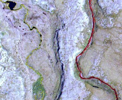
12 What sort of airphotos? In our region there are no high-res or contemporary DEM products DEMs from the National Elevation Dataset (NED) Interpolated from 1 : 63,360 contour lines on USGS quads many not updated since 1950s Automated orthorectification not really an option for high-resolution imagery (unless we want to fly an ifsar or LiDAR DEM as well) That leaves us with a stopgap method....
13 What sort of airphotos? In our region there are no high-res or contemporary DEM products DEMs from the National Elevation Dataset (NED) Interpolated from 1 : 63,360 contour lines on USGS quads many not updated since 1950s Automated orthorectification not really an option for high-resolution imagery (unless we want to fly an ifsar or LiDAR DEM as well) That leaves us with a stopgap method For now it works, but I look forward to the day when it s no longer necessary....


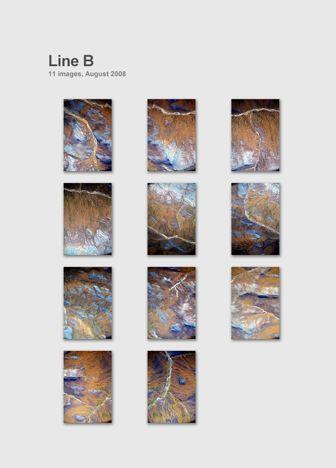
14 Camera: Nikon D2X Plane: Cessna 185 (192 shown)
15

16

17

18

19

20

21

22

23

24 2006

25 1985

26

27

28

29

30

31 Questions?
Aerial photography: Principles. Frame capture sensors: Analog film and digital cameras
 Aerial photography: Principles Frame capture sensors: Analog film and digital cameras Overview Introduction Frame vs scanning sensors Cameras (film and digital) Photogrammetry Orthophotos Air photos are
1. Introduction 2. Tectonics of NE Iceland Krafla rifting crisis (constraints from spy image matching)
") 1. Introduction 2. Tectonics of NE Iceland 3. 1975-1984 Krafla rifting crisis (constraints from spy image matching) 4. 1975-1984 Krafla rifting crisis (constraints from aerial photos) 5. Conclusions Tuesday
1. Introduction 2. Tectonics of NE Iceland 3. 1975-1984 Krafla rifting crisis (constraints from spy image matching) 4. 1975-1984 Krafla rifting crisis (constraints from aerial photos) 5. Conclusions Tuesday
Lesson 4: Photogrammetry
 This work by the National Information Security and Geospatial Technologies Consortium (NISGTC), and except where otherwise Development was funded by the Department of Labor (DOL) Trade Adjustment Assistance
Basics of Photogrammetry Note#6
 Basics of Photogrammetry Note#6 Photogrammetry Art and science of making accurate measurements by means of aerial photography Analog: visual and manual analysis of aerial photographs in hard-copy format
HARRIS GEOSPATIAL MARKETPLACE. HarrisGeospatial.com
 HARRIS GEOSPATIAL MARKETPLACE HarrisGeospatial.com Satellite image of Washington, D.C. Image courtesy of DigitalGlobe GET IT ALL IN ONE PLACE Data for Any Project Map Products Vis/Sim Products Geospatial
Flood modelling and management. Glasgow University. 8 September Paul Shaw - GeoVision
 Flood modelling and management Glasgow University 8 September 2004 Paul Shaw - GeoVision How important are heights in flood modelling? Comparison of data collection technologies GPS - Global Positioning
An Introduction to Geomatics. Prepared by: Dr. Maher A. El-Hallaq خاص بطلبة مساق مقدمة في علم. Associate Professor of Surveying IUG
 An Introduction to Geomatics خاص بطلبة مساق مقدمة في علم الجيوماتكس Prepared by: Dr. Maher A. El-Hallaq Associate Professor of Surveying IUG 1 Airborne Imagery Dr. Maher A. El-Hallaq Associate Professor
Lecture 13: Remotely Sensed Geospatial Data
 Lecture 13: Remotely Sensed Geospatial Data A. The Electromagnetic Spectrum: The electromagnetic spectrum (Figure 1) indicates the different forms of radiation (or simply stated light) emitted by nature.
ENVI Tutorial: Orthorectifying Aerial Photographs
 ENVI Tutorial: Orthorectifying Aerial Photographs Table of Contents OVERVIEW OF THIS TUTORIAL...2 ORTHORECTIFYING AERIAL PHOTOGRAPHS IN ENVI...2 Building the interior orientation...3 Building the exterior
Photogrammetry. Lecture 4 September 7, 2005
 Photogrammetry Lecture 4 September 7, 2005 What is Photogrammetry Photogrammetry is the art and science of making accurate measurements by means of aerial photography: Analog photogrammetry (using films:
Managing and serving large collections of imagery
 IOP Conference Series: Earth and Environmental Science OPEN ACCESS Managing and serving large collections of imagery To cite this article: V Viswambharan 2014 IOP Conf. Ser.: Earth Environ. Sci. 18 012062
9/13/2011. Training Course Remote Sensing Basic Theory & Image Processing Methods September 2011
 Training Course Remote Sensing Basic Theory & Image Processing Methods 19 23 September 2011 DIGITAL TERRAIN MODELS Introduction Michiel Damen (April 2011) damen@itc.nl 1 Digital Elevation and Terrain Models
The Airphoto Ortho Suite is an add-on to Geomatica. It requires Geomatica Core or Geomatica Prime as a pre-requisite.
 Airphoto Ortho Suite The Airphoto Ortho Suite includes rigorous models used to correct the geometry of analogue and digital/video cameras and to produce orthorectified air photos. These models compensate
EarthData International
 (Part 2) EarthData International >> By Marc S. Cheves, LS In the Charter Issue we ran a story about Bryan Logan and EarthData International. In this issue we serve up another slice of the EarthData information:
Leica - 3 rd Generation Airborne Digital Sensors Features / Benefits for Remote Sensing & Environmental Applications
 Leica - 3 rd Generation Airborne Digital Sensors Features / Benefits for Remote Sensing & Environmental Applications Arthur Rohrbach, Sensor Sales Dir Europe, Middle-East and Africa (EMEA) Luzern, Switzerland,
Monitoring the vegetation success of a rehabilitated mine site using multispectral UAV imagery. Tim Whiteside & Renée Bartolo, eriss
 Monitoring the vegetation success of a rehabilitated mine site using multispectral UAV imagery Tim Whiteside & Renée Bartolo, eriss About the Supervising Scientist Main roles Working to protect the environment
Progress Towards the Seamless Combination of Bathymetric and Topographic Data in New Zealand
 Progress Towards the Seamless Combination of Bathymetric and Topographic Data in New Zealand Matt Amos Senior Technical Advisor National Geodetic Office Introduction Datasets usually defined in terms of
MSB Imagery Program FAQ v1
 MSB Imagery Program FAQ v1 (F)requently (A)sked (Q)uestions 9/22/2016 This document is intended to answer commonly asked questions related to the MSB Recurring Aerial Imagery Program. Table of Contents
What is the scale of this vertical aerial photo? Small or large scale??
 What is the scale o this vertical aerial photo? Small or large scale?? SCALE what does it mean? the relationship between linear distance on a photo (or a map) and the corresponding actual distance on the
ENVI Orthorectification Module
 ENVI Orthorectification Module Orthorectify your imagery quickly and easily. CREASO - your partner for visual information solutions Rigorous Orthorectification. Simple Workflow. Trusted Method. The Need
SAR Imagery: Airborne or Spaceborne? Presenter: M. Lorraine Tighe PhD
 SAR Imagery: Airborne or Spaceborne? Presenter: M. Lorraine Tighe PhD Introduction The geospatial community has seen a plethora of spaceborne SAR imagery systems where there are now extensive archives
EVALUATION OF PLEIADES-1A TRIPLET ON TRENTO TESTFIELD
 EVALUATION OF PLEIADES-1A TRIPLET ON TRENTO TESTFIELD D. Poli a, F. Remondino b, E. Angiuli c, G. Agugiaro b a Terra Messflug GmbH, Austria b 3D Optical Metrology Unit, Fondazione Bruno Kessler, Trento,
remote sensing? What are the remote sensing principles behind these Definition
 Introduction to remote sensing: Content (1/2) Definition: photogrammetry and remote sensing (PRS) Radiation sources: solar radiation (passive optical RS) earth emission (passive microwave or thermal infrared
Remote Sensing of Active-Fire and Post-Fire Effects. Presentation 1-3 A Brief History of Fire-Related Remote Sensing
 Remote Sensing of Active-Fire and Post-Fire Effects Presentation 1-3 A Brief History of Fire-Related Remote Sensing Good Day! This lecture is entitled a brief history of fire-related remote sensing. In
Lab #10 Digital Orthophoto Creation (Using Leica Photogrammetry Suite)
") Lab #10 Digital Orthophoto Creation (Using Leica Photogrammetry Suite) References: Leica Photogrammetry Suite Project Manager: Users Guide, Leica Geosystems LLC. Leica Photogrammetry Suite 9.2 Introduction:
Lab #10 Digital Orthophoto Creation (Using Leica Photogrammetry Suite) References: Leica Photogrammetry Suite Project Manager: Users Guide, Leica Geosystems LLC. Leica Photogrammetry Suite 9.2 Introduction:
Technical Evaluation of Khartoum State Mapping Project
 Technical Evaluation of Khartoum State Mapping Project Nagi Zomrawi 1 and Mohammed Fator 2 1 School of Surveying Engineering, Collage of Engineering, Sudan University of Science and Technology, Khartoum,
VERTICAL AERIAL PHOTOGRAPHY
 VERTICAL AERIAL PHOTOGRAPHY Mike Craig Cooperative Research Centre for Landscape Environments and Mineral Exploration, Geoscience Australia. PO Box 378, Canberra, ACT 2601. E-mail: mike.craig@ga.gov.au
PROGRESS IN ADDRESSING SCIENCE GOALS FOR GLACIER OBSERVATIONS BY MEANS OF SAR. Frank Paul & Thomas Nagler
 PROGRESS IN ADDRESSING SCIENCE GOALS FOR GLACIER OBSERVATIONS BY MEANS OF SAR Frank Paul & Thomas Nagler SAR Coordination Working Group Meeting, 13/11/2016 Observed glacier products and sensors Product
Na6onal Agricultural Imagery Program (NAIP)
") Spa$al Workshop: Part 3 Other imagery sources CIR imagery NAIP, TM, Lidar/Radar NEXTMAP, others SNAMP Data sharing server How to access SNAMP data SNAMP website: Stay in touch! Na6onal Agricultural Imagery
Spa$al Workshop: Part 3 Other imagery sources CIR imagery NAIP, TM, Lidar/Radar NEXTMAP, others SNAMP Data sharing server How to access SNAMP data SNAMP website: Stay in touch! Na6onal Agricultural Imagery
Remote sensing in archaeology from optical to lidar. Krištof Oštir ModeLTER Scientific Research Centre of the Slovenian Academy of Sciences and Arts
 Remote sensing in archaeology from optical to lidar Krištof Oštir ModeLTER Scientific Research Centre of the Slovenian Academy of Sciences and Arts Introduction Optical remote sensing Systems Search for
GEO 428: DEMs from GPS, Imagery, & Lidar Tuesday, September 11
 GEO 428: DEMs from GPS, Imagery, & Lidar Tuesday, September 11 Global Positioning Systems GPS is a technology that provides Location coordinates Elevation For any location with a decent view of the sky
Sources of Geographic Information
 Sources of Geographic Information Data properties: Spatial data, i.e. data that are associated with geographic locations Data format: digital (analog data for traditional paper maps) Data Inputs: sampled
Active and Passive Microwave Remote Sensing
 Active and Passive Microwave Remote Sensing Passive remote sensing system record EMR that was reflected (e.g., blue, green, red, and near IR) or emitted (e.g., thermal IR) from the surface of the Earth.
Automatic geo-registration of satellite imagery
 Fjärranalysdagarna 10-11 mars 2009 Automatic geo-registration of satellite imagery Torbjörn Westin Lars-Åke Edgardh Ian Spence Spacemetric AB www.spacemetric.com Keystone Image Server Keystone is an automatic
What is Photogrammetry
 Photogrammetry What is Photogrammetry Photogrammetry is the art and science of making accurate measurements by means of aerial photography: Analog photogrammetry (using films: hard-copy photos) Digital
DETAILED CHANGE DETECTION USING HIGH SPATIAL RESOLUTION FRAME CENTER MATCHED AERIAL PHOTOGRAPHY INTRODUCTION
 DETAILED CHANGE DETECTION USING HIGH SPATIAL RESOLUTION FRAME CENTER MATCHED AERIAL PHOTOGRAPHY Lloyd L. Coulter, Steven J. Lathrop, and Douglas A. Stow Department of Geography San Diego State University
Peace Project Water Use Plan. Williston Air Photos and DEM. Reference: GMSWORKS #14. Williston Air Photos and DEM 2011
 Peace Project Water Use Plan Williston Air Photos and DEM Reference: GMSWORKS #14 Williston Air Photos and DEM 2011 Study Period: May 2011 to December 2011 Les Giles Transmission Engineering, Photogrammetry
Govt. Engineering College Jhalawar Model Question Paper Subject- Remote Sensing & GIS
 Govt. Engineering College Jhalawar Model Question Paper Subject- Remote Sensing & GIS Time: Max. Marks: Q1. What is remote Sensing? Explain the basic components of a Remote Sensing system. Q2. What is
Planning urban areas
 Planning urban areas Wizards Map production 3D presentations Annotation Orthophoto Surface gridding Contouring Image mosaicing Data compression Geocoding Spatial analysis Raster to vector Land use classification
TEMPORAL ANALYSIS OF MULTI EPOCH LANDSAT GEOCOVER IMAGES IN ZONGULDAK TESTFIELD
 TEMPORAL ANALYSIS OF MULTI EPOCH LANDSAT GEOCOVER IMAGES IN ZONGULDAK TESTFIELD Şahin, H. a*, Oruç, M. a, Büyüksalih, G. a a Zonguldak Karaelmas University, Zonguldak, Turkey - (sahin@karaelmas.edu.tr,
Planet Labs Inc 2017 Page 2
 SKYSAT IMAGERY PRODUCT SPECIFICATION: ORTHO SCENE LAST UPDATED JUNE 2017 SALES@PLANET.COM PLANET.COM Disclaimer This document is designed as a general guideline for customers interested in acquiring Planet
PEGASUS : a future tool for providing near real-time high resolution data for disaster management. Lewyckyj Nicolas
 PEGASUS : a future tool for providing near real-time high resolution data for disaster management Lewyckyj Nicolas nicolas.lewyckyj@vito.be http://www.pegasus4europe.com Overview Vito in a nutshell GI
Using High-Res. Orthoimagery for Environmental Change Detection & Analysis in Northern Alaska
 Using High-Res. Orthoimagery for Environmental Change Detection & Analysis in Northern Alaska William F. Manley Leanne R. Lestak INSTAAR, University of Colorado INSTAAR, University of Colorado 1 Talk Outline
First Exam. Geographers Tools: Gathering Information. Photographs and Imagery. SPIN 2 Image of Downtown Atlanta, GA 1995 REMOTE SENSING 9/19/2016
 First Exam Geographers Tools: Gathering Information Prof. Anthony Grande Hunter College Geography Lecture design, content and presentation AFG 0616. Individual images and illustrations may be subject to
Working with Elevation Services. Cody Benkelman
 Working with Elevation Services Cody Benkelman Outline ArcGIS Online World Elevation & 3D Elevation Cache for Pro What is included? - Data and Tools How can I use it? - Modes of use - Client Applications
APCAS/10/21 April 2010 ASIA AND PACIFIC COMMISSION ON AGRICULTURAL STATISTICS TWENTY-THIRD SESSION. Siem Reap, Cambodia, April 2010
 APCAS/10/21 April 2010 Agenda Item 8 ASIA AND PACIFIC COMMISSION ON AGRICULTURAL STATISTICS TWENTY-THIRD SESSION Siem Reap, Cambodia, 26-30 April 2010 The Use of Remote Sensing for Area Estimation by Robert
OUR INDUSTRIAL LEGACY WHAT ARE WE LEAVING OUR CHILDREN REAAA Roadshow Taupo, August 2016 Young presenter s competition
 OUR INDUSTRIAL LEGACY WHAT ARE WE LEAVING OUR CHILDREN Preserving the country s aerial photography archive for future generations Abstract For over eighty years, aerial photography has captured the changing
Correcting topography effects on terrestrial radar maps
 Correcting topography effects on terrestrial radar maps M. Jaud, R. Rouveure, P. Faure, M-O. Monod, L. Moiroux-Arvis UR TSCF Irstea, National Research Institute of Science and Technology for Environment
ENVI Orthorectification Module
 Visual Information Solutions ENVI Orthorectification Module Orthorectify Your Imagery Quickly and Easily. Rigorous Orthorectification. Simple Workflow. Trusted Method. The Need for Orthorectification Satellite
First Exam: New Date. 7 Geographers Tools: Gathering Information. Photographs and Imagery REMOTE SENSING 2/23/2018. Friday, March 2, 2018.
 First Exam: New Date Friday, March 2, 2018. Combination of multiple choice questions and map interpretation. Bring a #2 pencil with eraser. Based on class lectures supplementing chapter 1. Review lecture
Aerial photography and Remote Sensing. Bikini Atoll, 2013 (60 years after nuclear bomb testing)
") Aerial photography and Remote Sensing Bikini Atoll, 2013 (60 years after nuclear bomb testing) Computers have linked mapping techniques under the umbrella term : Geomatics includes all the following spatial
Aerial photography and Remote Sensing Bikini Atoll, 2013 (60 years after nuclear bomb testing) Computers have linked mapping techniques under the umbrella term : Geomatics includes all the following spatial
THREE-DIMENSIONAL MAPPING USING BOTH AIRBORNE AND SPACEBORNE IFSAR TECHNOLOGIES ABSTRACT INTRODUCTION
 THREE-DIMENSIONAL MAPPING USING BOTH AIRBORNE AND SPACEBORNE IFSAR TECHNOLOGIES Trina Kuuskivi Manager of Value Added Products and Services, Intermap Technologies Corp. 2 Gurdwara Rd, Suite 200, Ottawa,
Geographic information - Imagery and gridded data. Wolfgang Kresse
 Geographic information - Imagery and gridded data Wolfgang Kresse kresse@fh-nb.de Imagery Data taken by IRS-1C and LandsatTM Eftas, Münster, Germany Gridded data Grid Value Matrix Associated Metadata Attribute
A (very) brief introduction to Remote Sensing: From satellites to maps!
 brief introduction to Remote Sensing: From satellites to maps!") Spatial Data Analysis and Modeling for Agricultural Development, with R - Workshop A (very) brief introduction to Remote Sensing: From satellites to maps! Earthlights DMSP 1994-1995 https://wikimedia.org/
Spatial Data Analysis and Modeling for Agricultural Development, with R - Workshop A (very) brief introduction to Remote Sensing: From satellites to maps! Earthlights DMSP 1994-1995 https://wikimedia.org/
EnsoMOSAIC Aerial mapping tools
 EnsoMOSAIC Aerial mapping tools Jakarta and Kuala Lumpur, 2013 Contents MosaicMill MM Application examples Software introduction System introduction Rikola HS sensor UAV platform examples SW Syst HS UAV
Use of digital aerial camera images to detect damage to an expressway following an earthquake
 Use of digital aerial camera images to detect damage to an expressway following an earthquake Yoshihisa Maruyama & Fumio Yamazaki Department of Urban Environment Systems, Chiba University, Chiba, Japan.
First Exam: Thurs., Sept 28
 8 Geographers Tools: Gathering Information Prof. Anthony Grande Hunter College Geography Lecture design, content and presentation AFG 0917. Individual images and illustrations may be subject to prior copyright.
SPOT 5 / HRS: a key source for navigation database
 SPOT 5 / HRS: a key source for navigation database CONTENT DEM and satellites SPOT 5 and HRS : the May 3 rd 2002 revolution Reference3D : a tool for navigation and simulation Marc BERNARD Page 1 Report
7 Geographers Tools: Gathering Information
 FIRST EXAM TODAY ExCr ATLAS EXERCISE for EXAM I is DUE. Bubble in your vtues., Feb. 26, 2019. Pass Scantrons forward. name on the back. Combination of multiple choice questions and map interpretation.
UltraCam and UltraMap Towards All in One Solution by Photogrammetry
 Photogrammetric Week '11 Dieter Fritsch (Ed.) Wichmann/VDE Verlag, Belin & Offenbach, 2011 Wiechert, Gruber 33 UltraCam and UltraMap Towards All in One Solution by Photogrammetry ALEXANDER WIECHERT, MICHAEL
Outline Remote Sensing Defined Resolution Electromagnetic Energy (EMR) Types Interpretation Applications
 Types Interpretation Applications") Introduction to Remote Sensing Outline Remote Sensing Defined Resolution Electromagnetic Energy (EMR) Types Interpretation Applications Remote Sensing Defined Remote Sensing is: The art and science of
Introduction to Remote Sensing Outline Remote Sensing Defined Resolution Electromagnetic Energy (EMR) Types Interpretation Applications Remote Sensing Defined Remote Sensing is: The art and science of
Geomatica OrthoEngine v10.2 Tutorial DEM Extraction of GeoEye-1 Data
 Geomatica OrthoEngine v10.2 Tutorial DEM Extraction of GeoEye-1 Data GeoEye 1, launched on September 06, 2008 is the highest resolution commercial earth imaging satellite available till date. GeoEye-1
USE OF SMALL FORMAT DIGITAL AERIAL IMAGES FOR CLASSIFICATION OF SATELLITE IMAGES
 USE OF SMALL FORMAT DIGITAL AERIAL IMAGES FOR CLASSIFICATION OF SATELLITE IMAGES A. Abd-Elrahman 1, L. Pearlstine 1, S. Smith 1 and P. Princz 2 1 Geomatics Program, University of Florida Gainesville, FL
The Investigation of Classification Methods of High-Resolution Imagery
 The Investigation of Classification Methods of High-Resolution Imagery Tracey S. Frescino 1, Gretchen G. Moisen 2, Larry DeBlander 3, and Michel Guerin 4 Abstract. As remote-sensing technology advances,
EarthData International
 (Part 3) EarthData International >> By Marc S. Cheves, LS I recently met with Jeff Leonard, President and General Manager of EarthData International in Frederick, Maryland, and Tom Harrington, President
Orthoimagery Standards. Chatham County, Georgia. Jason Lee and Noel Perkins
 1 Orthoimagery Standards Chatham County, Georgia Jason Lee and Noel Perkins 2 Table of Contents Introduction... 1 Objective... 1.1 Data Description... 2 Spatial and Temporal Environments... 3 Spatial Extent
Application of Satellite Remote Sensing for Natural Disasters Observation
 Application of Satellite Remote Sensing for Natural Disasters Observation Prof. Krištof Oštir, Ph.D. University of Ljubljana Faculty of Civil and Geodetic Engineering Outline Earth observation current
Suveying Lectures for CE 498
 Suveying Lectures for CE 498 SURVEYING CLASSIFICATIONS Surveying work can be classified as follows: 1- Preliminary Surveying In this surveying the detailed data are collected by determining its locations
Acquisition of Aerial Photographs and/or Satellite Imagery
 Acquisition of Aerial Photographs and/or Satellite Imagery Acquisition of Aerial Photographs and/or Imagery From time to time there is considerable interest in the purchase of special-purpose photography
Workshop on Network Planning for English speaking African Countries
 Welcome! Workshop on Network Planning for English speaking African Countries (ITU COE, Nairobi, Kenya, 7-11 October 2002) 1 Welcome! Session 5.6 Supporting Network Planning Tools I by Roland Götz 2 Dipl.-Ing.
Geomatica OrthoEngine Orthorectifying SPOT6 data
 Geomatica OrthoEngine Orthorectifying SPOT6 data On September 9, 2012, SPOT 6 was launched adding to the constellation of Earthimaging satellites designed to provide 1.5m high-resolution data. The architecture
WGISS-42 USGS Agency Report
 WGISS-42 USGS Agency Report U.S. Department of the Interior U.S. Geological Survey Kristi Kline USGS EROS Center Major Activities Landsat Archive/Distribution Changes Land Change Monitoring, Assessment,
Looking at the new ASTER 30 m DEMs not so impressive relative to SRTM 90 m
 ASU Blogs Feedback Next Blog >> Arrowsmith blog Part of the blog.asu.edu community «Analysis of LiDAR data covering Luke Wash area west of Phoenix: notes on processing and comparison with USGS DEMs M6.9
Using Freely Available. Remote Sensing to Create a More Powerful GIS
 Using Freely Available Government Data and Remote Sensing to Create a More Powerful GIS All rights reserved. ENVI, E3De, IAS, and IDL are trademarks of Exelis, Inc. All other marks are the property of
PROGRESS IN ADDRESSING SCIENCE GOALS FOR GLACIER OBSERVATIONS BY MEANS OF SAR
 PROGRESS IN ADDRESSING SCIENCE GOALS FOR GLACIER OBSERVATIONS BY MEANS OF SAR Frank Paul, Thomas Nagler, Dana Floricioiu, et al. PSTG, 13/9/2016 Panmah, Karakoram Observed glacier products and sensors
FOR 474: Forest Inventory. FOR 474: Forest Inventory. Why do we Care About Forest Sampling?
 FOR 474: Forest Inventory 1. Advanced Forest Inventory The Need for Forest Sampling Brief Intro to Remote Sensing and GIS Readings: FOR 474: Forest Inventory Related Courses! FOR 274: Forest Measurements
Can Satellite Image Analysis Replace Manual Digitization?
 Can Satellite Image Analysis Replace Manual Digitization? GeoDATA London 30 th Nov 2017 LUCY KENNEDY Spottitt CEO Lucy.Kennedy@spottitt.com +44 772 594 4643 Agenda Why develop processes and services based
UAV PHOTOGRAMMETRY COMPARED TO TRADITIONAL RTK GPS SURVEYING
 UAV PHOTOGRAMMETRY COMPARED TO TRADITIONAL RTK GPS SURVEYING Brad C. Mathison and Amber Warlick March 20, 2016 Fearless Eye Inc. Kansas City, Missouri www.fearlesseye.com KEY WORDS: UAV, UAS, Accuracy
Land cover change methods. Ned Horning
 Land cover change methods Ned Horning Version: 1.0 Creation Date: 2004-01-01 Revision Date: 2004-01-01 License: This document is licensed under a Creative Commons Attribution-Share Alike 3.0 Unported License.
The Normal Baseline. Dick Gent Law of the Sea Division UK Hydrographic Office
 The Normal Baseline Dick Gent Law of the Sea Division UK Hydrographic Office 2 The normal baseline for measuring the breadth of the territorial sea is the low water line along the coast as marked on large
Introduction to Remote Sensing
 Introduction to Remote Sensing Outline Remote Sensing Defined Resolution Electromagnetic Energy (EMR) Types Interpretation Applications Remote Sensing Defined Remote Sensing is: The art and science of
AERIAL SURVEYS COMPANY PROFILE
 AERIAL SURVEYS COMPANY PROFILE Aerial Surveys, previously known as GeoSmart, is an innovative aerial photography and geospatial mapping service provider Our services enable customers to make better business
Old aerial view of my house
 Мобильный портал WAP версия: wap.altmaster.ru Old aerial view of my house Vintage Aerial has more than 18 million photos, taken in 41 states over the second half of the twentieth century. If you are looking
Project Planning and Cost Estimating
 CHAPTER 17 Project Planning and Cost Estimating 17.1 INTRODUCTION Previous chapters have outlined and detailed technical aspects of photogrammetry. The basic tasks and equipment required to create various
Chapter 1 Overview of imaging GIS
 Chapter 1 Overview of imaging GIS Imaging GIS, a term used in the medical imaging community (Wang 2012), is adopted here to describe a geographic information system (GIS) that displays, enhances, and facilitates
New Constellations, New Capabilities, and Future Opportunities
 New Constellations, New Capabilities, and Future Opportunities PETER KINNE REGIONAL DIRECTOR DIGITALGLOBE See a better world. The Past HOW FAR HAVE WE COME? See a better world. 1783 - Take couple of French
Baldwin and Mobile Counties, AL Orthoimagery Project Report. Submitted: March 23, 2016
 2015 Orthoimagery Project Report Submitted: Prepared by: Quantum Spatial, Inc 523 Wellington Way, Suite 375 Lexington, KY 40503 859-277-8700 Page i of iii Contents Project Report 1. Summary / Scope...
Phase One 190MP Aerial System
 White Paper Phase One 190MP Aerial System Introduction Phase One Industrial s 100MP medium format aerial camera systems have earned a worldwide reputation for its high performance. They are commonly used
DEMS BASED ON SPACE IMAGES VERSUS SRTM HEIGHT MODELS. Karsten Jacobsen. University of Hannover, Germany
 DEMS BASED ON SPACE IMAGES VERSUS SRTM HEIGHT MODELS Karsten Jacobsen University of Hannover, Germany jacobsen@ipi.uni-hannover.de Key words: DEM, space images, SRTM InSAR, quality assessment ABSTRACT
GXL 2015 Technical Description
 GXL 2015 Technical Description Table of Contents SYSTEM ARCHITECTURE... 4 GXL SYSTEM OVERVIEW... 4 GXL SYSTEM COMPONENTS... 5 GXL Processing Server(s)... 5 GXL Controller... 5 GXL Interface (thin Client)...
HIGH RESOLUTION COLOR IMAGERY FOR ORTHOMAPS AND REMOTE SENSING. Author: Peter Fricker Director Product Management Image Sensors
 HIGH RESOLUTION COLOR IMAGERY FOR ORTHOMAPS AND REMOTE SENSING Author: Peter Fricker Director Product Management Image Sensors Co-Author: Tauno Saks Product Manager Airborne Data Acquisition Leica Geosystems
IMAGE ACQUISITION GUIDELINES FOR SFM
 IMAGE ACQUISITION GUIDELINES FOR SFM a.k.a. Close-range photogrammetry (as opposed to aerial/satellite photogrammetry) Basic SfM requirements (The Golden Rule): minimum of 60% overlap between the adjacent
Geometry of Aerial Photographs
 Geometry of Aerial Photographs Aerial Cameras Aerial cameras must be (details in lectures): Geometrically stable Have fast and efficient shutters Have high geometric and optical quality lenses They can
APPLICATIONS AND LESSONS LEARNED WITH AIRBORNE MULTISPECTRAL IMAGING
 APPLICATIONS AND LESSONS LEARNED WITH AIRBORNE MULTISPECTRAL IMAGING James M. Ellis and Hugh S. Dodd The MapFactory and HJW Walnut Creek and Oakland, California, U.S.A. ABSTRACT Airborne digital frame
Hydraulics and Floodplain Modeling Managing HEC-RAS Cross Sections
 WMS 10.1 Tutorial Hydraulics and Floodplain Modeling Managing HEC-RAS Cross Sections Modify cross sections in an HEC-RAS model to use surveyed cross section data v. 10.1 Objectives Build a basic HEC-RAS
Spatial Analyst is an extension in ArcGIS specially designed for working with raster data.
 Spatial Analyst is an extension in ArcGIS specially designed for working with raster data. 1 Do you remember the difference between vector and raster data in GIS? 2 In Lesson 2 you learned about the difference
Image Acquisition Campaign 2008
 Madrid, 12-14 November, 2007 Geomatics in Support of the CAP 1 Image Acquisition Campaign 2008 Pär Johan Åstrand, Maria Erlandsson Mihaela Fotin, Cherith Aspinall JRC, CID JRC, CID Madrid, 12-14 November,
LECTURE NOTES 2016 CONTENTS. Sensors and Platforms for Acquisition of Aerial and Satellite Image Data
 LECTURE NOTES 2016 Prof. John TRINDER School of Civil and Environmental Engineering Telephone: (02) 9 385 5020 Fax: (02) 9 313 7493 j.trinder@unsw.edu.au CONTENTS Chapter 1 Chapter 2 Sensors and Platforms
Stereo satellite elevation mapping for stakeless 3D seismic surveying. Demonstration Project BP Libya
 Stereo satellite elevation mapping for stakeless 3D seismic surveying. Demonstration Project BP Libya Project Location Gerry Mitchell PhotoSat 16 km 50cm resolution stereo WorldView-2 2 satellite photo
High Resolution Sensor Test Comparison with SPOT, KFA1000, KVR1000, IRS-1C and DPA in Lower Saxony
 High Resolution Sensor Test Comparison with SPOT, KFA1000, KVR1000, IRS-1C and DPA in Lower Saxony K. Jacobsen, G. Konecny, H. Wegmann Abstract The Institute for Photogrammetry and Engineering Surveys