EnsoMOSAIC Aerial mapping tools
|
|
|
- Cuthbert Jackson
- 6 years ago
- Views:
Transcription
1 EnsoMOSAIC Aerial mapping tools Jakarta and Kuala Lumpur, 2013
2 Contents MosaicMill MM Application examples Software introduction System introduction Rikola HS sensor UAV platform examples SW Syst HS UAV MosaicMill Ltd
 Main businesses EnsoMOSAIC image processing software sales UAV and conventional EnsoMOSAIC aerial imaging system sales conventional Clients Mapping organizations UAV manufacturers Forestry")
3 MM Company introduction MosaicMill founded in 2009 Technology EnsoMOSAIC since 1995 (Stora Enso Ltd.) Main businesses EnsoMOSAIC image processing software sales UAV and conventional EnsoMOSAIC aerial imaging system sales conventional Clients Mapping organizations UAV manufacturers Forestry organizations Oil companies Plantation companies Mining companies Universities Power line companies MosaicMill Ltd
4 MM MosaicMill and partners ESPA Systems 3D M. Rantasuo Electronics Rikola Hyperspectral Simosol Programming MosaicMill Marketing Sales Support PIEneering Photogrammetry Direct sales ~50 % 30 Resellers 100+ clients 30+ countries MosaicMill Ltd

5 MM Why EnsoMOSAIC? Gatewing x100, TSKAY; Malaysia MosaicMill Ltd

6 MM EnsoMOSAIC applications examples Topographic mapping Volume calculations Agriculture HS sensor Corridors and power lines Forestry Large area mapping MosaicMill Ltd
7 MM Why EnsoMOSAIC benefits Substitute ground topographic survey Low-altitude UAV very high GSD (e.g. 5 cm vs. 10 m) Cost and speed Substitute LiDAR Create LiDAR-like elevation point cloud DSM Contours Huge cost difference, both in investment and operation. Benefits compared to Conventional big frame aerial photos: Flexible, low cost and quick reaction : Client request fly deliver, same day Operate under cloud cover No own aircraft required low investment cost EnsoMOSAIC is target-specific Mapping of only the change area low costs Monitor frequently Control volume and value of assets regularly. Control the entire production chain Benefits compared to high resolution satellite imagery Cloudy areas: No satellite imagery EnsoMOSAIC provides accurate DEM MosaicMill Ltd
8 EnsoMOSAIC Software EnsoMOSAIC image rectification Rapidterrain point cloud EnsoMOSAIC 3D


 Spatial resolution: 0.05-2.")
 Radiometric resolution: 8-14 bits /")
9 SW EnsoMOSAIC specifications INPUTS Small, medium or large format images GPS coordinates for each image Optional: Camera (or aircraft) exterior orientation FUNCTIONS Automatic processing of ortho-mosaics from airborne digital images Thousands of digital images on one run OUTPUTS Orthomosaics, Orthoimages and Oriented images: Horizontal accuracy: 1-2 pix (ground control, DEM) 2 m (single freq GPS only) Spatial resolution: m Spectral resolution: RGB, CIR, Thermal (camera-dependent) Radiometric resolution: 8-14 bits / channel (camera-dependent) MosaicMill Ltd


10 SW EnsoMOSAIC orthorectification processing steps Ground Control Points Aerial triangulation and Block adjustment Quality control Orthomosaicking MosaicMill Ltd

11 SW Rapid Terrain point cloud Input: EnsoMOSAIC ortho results: image external orientation, mosaic Functions: automatic calculating very dense point clouds. Generating DEM and DSM, applicable in the most demanding application areas with e.g. vertical cliffs or very high buildings. Output: ASCII XYZ point cloud, RASTER DEM, editable in EnsoMOSAIC 3D. MosaicMill Ltd

 OUTPUTS Surface models, Terrain models Contours,")
 Max Z point density: 1 pixel")
12 SW EnsoMOSAIC 3D specifications INPUTS Oriented images from EnsoMOSAIC or Point cloud from RapidTerrain FUNCTIONS Photogrammetric extraction of elevations 3D-digitizing 3D-viewing Volume calculation (between two elevation models) OUTPUTS Surface models, Terrain models Contours, 3D-vectors 3D-visualization Vertical accuracy: pix (when all error sources controlled) Max Z point density: 1 pixel Max DSM density: 2 pixels MosaicMill Ltd
13 SW Camera calibration WHY? Standard cameras have lens distortion not suitable for professional mapping Camera parameters are required for fast automatic image processing FUNCTIONS Calculate exact camera interior orientation (camera parameters) to convert standard camera into metric one for accurate mapping OUTPUTS Focal length Principal point Radial and tangential lens distortion MosaicMill Ltd

14 SW Camera calibration Testfield dimensions Testfield hardware Labelled marks on corners Optimal calibration geometry, exposure locations WS Business Intelligence 17/12/
15 SW DigiPreProcess Image enhancement WHY? Part of information in digital camera images lost or unused Enable image capture in RAW format instead of JPG improve image quality (12-14 bits instead of 8 bits) FUNCTIONS Convert RAW images into optimized TIF images Adaptive modeling of lens vignetting and hot spots OUTPUTS Corrected and spectrally optimized images MosaicMill Ltd


16 SW DigiPreProcess Image enhancement Before DigiPreProcess - RAW 12-bit image After DigiPreProcess - TIF 8-bit CIR image MosaicMill Ltd
17 SW SeamLineEditor Mosaic enhancement WHY? In areas with sharp elevation differences and without a perfect elevation model, there seem to be linear cuts in mosaics. This effect is especially visible in urban areas. FUNCTIONS Define seam lines for image blocks (typically digitize centerlines of principal roads) OUTPUTS Corrected continuous mosaic without cut lines MosaicMill Ltd


18 SW SeamLineEditor Mosaic enhancement Before applying seam lines After applying seam lines MosaicMill Ltd
19 EnsoMOSAIC Complete imaging system


20 Syst EnsoMOSAIC complete system Imaging hardware Processing hardware Software EnsoMOSAIC for conventional flight + + Control box with GPS Digital camera: RGB, CIR, hyperspectral Laptop PC for navigation or Any UAV platform Standard PC 3D screen NavCam: Navigation EnsoMOSAIC ortho EnsoMOSAIC point cloud EnsoMOSAIC 3D + Training Maintenance Support MosaicMill Ltd

21 Syst Work flow conventional system 1. Planning 2. Imaging 3. Orthorectification 4. 3D-processing EnsoMOSAIC FlyPlan EnsoMOSAIC imaging Hardware + NavCam EnsoMOSAIC ortho EnsoMOSAIC point cloud or EnsoMOSAIC 3D numeric and graphical planning Typical altitude m Productivity 15,000 30,000 ha / h Ground resolution cm Input from flight control First results same day Automatic: aerotriangulation and mosaicking Input from aerotriangulation Automatic: Surface models and contours Manual: 3D vectors + detailed 3D mapping Images Orthophotos, Image mosaics City models Topo maps 3D measurements Volumes MosaicMill Ltd
22 Syst Work flow UAV platform 1. Planning 2. Imaging 3. Orthorectification 4. 3D-processing Planning tools by UAV manufacturer Practically any UAV system EnsoMOSAIC UAV EnsoMOSAIC point cloud or EnsoMOSAIC 3D Mission planning Typical altitude m Productivity ha / h Ground resolution 5 10 cm Input from autopilot First results same day Automatic: aerotriangulation and mosaicking Input from aerotriangulation Automatic: Surface models and contours Manual: 3D vectors + detailed 3D mapping Images Orthophotos, Image mosaics City models Topo maps 3D measurements Volumes MosaicMill Ltd
23 Syst Business opportunities Imaging service Georeferenced imagery VALUE Mapping service Orthoimages Image maps Value-added service Interpretation Classification 3D-modelling For companies and organizations managing their own assets or land resources For start-up businesses - low initial investment and easy to apply For ground survey companies utilize alternative tools For aerial imaging companies use efficient software MosaicMill Ltd
24 Syst Achieved accuracies System accuracy depends on applied GPS technology and GCP measurements Example 1 standard single frequency GPS 2 meters accuracy Example 2 standard single frequency GPS + GCPs 1 pixel XY accuracy 2 pixels Z accuracy Example 3 double frequency DGPS 0.1 m 0.5 m XY accuracy Example 4 - DGPS + IMU m XY accuracy System accuracy should be defined according to application needs, higher accuracy means higher investment costs MosaicMill Ltd

 Outputs image data cubes MosaicMill")
25 HS Rikola HS camera Frame based hyperspectral solution Lightweight, small and handheld size High accuracy image mosaics at low cost for UAV platform Fabry- Perot Interferometer (FPI) Outputs image data cubes MosaicMill Ltd
 Total time, e.g. data cube of 32 bands 1.4 sec Optical system: focal length 6mm, F-number 2.")
26 HS Technical specifications Weight: < 600g Max 50 bands by data cube Min. spectral resolution: 10nm Image resolution max x 1024 Spectral range: nm (spectral step 1nm) Total time, e.g. data cube of 32 bands 1.4 sec Optical system: focal length 6mm, F-number 2.7, FOV 39 o MosaicMill Ltd
27 HS Fabry-Perot Courtesy of Heikki Saari/VTT, Novel MEMS and Piezoactuated Fabry-Perot spectral imagers for atmospherics studies, 38th Annual European Meeting on Atmospheric Studies by Optical Methods MosaicMill Ltd


28 HS Hyperspectral mosaics 667nm 771nm 834nm One-band mosaics created by EnsoMOSAIC MosaicMill Ltd
 Red band 668nm and NIR")
29 HS applications NDVI vs. NRVI (Normalized Ratio Vegetation Index) Red band 668nm and NIR band 834nm MosaicMill Ltd


30 EnsoMOSAIC single orthorectified image MosaicMill Ltd


31 EnsoMOSAIC orthorectified mosaic MosaicMill Ltd

32 EnsoMOSAIC Hyperspectral mosaic Hyperspectral (up to 25 channels) are processed same way as standard mosaics Rikola hyperspectral camera applied MosaicMill Ltd

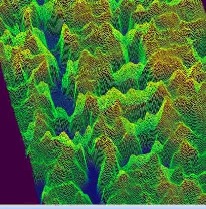
33 EnsoMOSAIC contour maps and 3D models MosaicMill Ltd


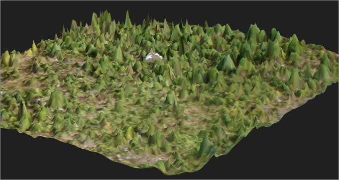
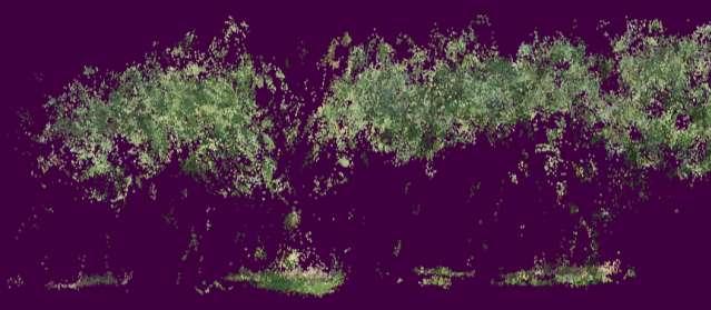
34 EnsoMOSAIC 3D point clouds MosaicMill Ltd

35 3D - results DSM, photogrammetric process only, 0.5 m resolution MosaicMill Ltd

36 EnsoMOSAIC FOREST INVENTORY AND MANAGEMENT PLANNING MosaicMill Ltd
37 EnsoMOSAIC TOPOGRAPHIC MAPPING MosaicMill Ltd
38 EnsoMOSAIC PLANTATIONS MONITORING MosaicMill Ltd


39 EnsoMOSAIC LOG YARD AND STOCK PILE INVENTORY MosaicMill Ltd

40 EnsoMOSAIC CIR mosaic CIR mosaics (Colour Infra Red) are processed same way as standard mosaics Camera modified from standard digital camera to capture infra red MosaicMill Ltd
41 EnsoMOSAIC UAV platforms
")

42 UAV UAVs for mapping UAV = Unmanned Aerial Vehicle Autonomous = with pre-programmable autopilot Excludes radio controlled aircraft (for hobby) Civil sector Excludes military (95+ % of ) For remote sensing With a compact or SLR camera Excludes research (e.g. High altitude high endurance) MosaicMill Ltd


43 UAV Platforms By weight Light (micro) < 2 kg Small 3-15 kg (e.g. Bramor, Idetec) Medium < 150 kg By engine type Electric Combustible (piston, turbine) By design Fixed wing Helicopter By endurance Short (<45 min) Short+ (<1.5 hours Medium (2-6 hours) Most UAVs suitable for mapping, fixed wing vehicles more stable, payload should be at least 0.3 kg MosaicMill Ltd
44 UAV Bottlenecks of UAV mapping All hardware and software related problems solved, high accuracy orthomaps and DEMs can be processed if the following issues controlled: Mission planning with high image overlap Platform with proper payload and endurance Fixed focal length camera GPS + IMU + Image synchronization Proper camera calibration Camera calibration software Ground Control few GCPs / project to meet the highest standards Advanced photogrammetry for hundreds or thousands of images EnsoMOSAIC UAV and EnsoMOSAIC 3D Legislation the only real bottleneck MosaicMill Ltd

45 UAV Limitations Rules and regulations Do not exist for autonomous UAVs - Under development (EU USA) Flying in-sight only in many countries Physical Endurance, power source Training, operator skills Professional use Risk of accident Use UAVs only for small or medium size areas, areas over 50 km2 always with manned vehicle MosaicMill Ltd

46 UAV example: Bramor by C-Astral Cruise speed 58 km/h Endurance up to 120 min Area coverage up to 10 km2 Optimum weight 3.3. kg Parachute landing 25 Mpix sensor 100 % compatibility with EnsoMOSAIC MosaicMill Ltd

47 UAV example: Idetec MosaicMill Ltd

48 UAV example: Idetec Stardust II MosaicMill Ltd


49 UAV example: Cropcam MosaicMill Ltd

50 UAV Examples: Gatewing UX5 MosaicMill Ltd


51 UAV Examples: UAVER MosaicMill Ltd
52 Supporting slides MosaicMill Ltd
53 EnsoMOSAIC complete system Delivery and installation Licensing through MosaicMill ( Evaluation licenses available for one month Training provided in user s premises, both for flying and processing Typical training times Survey planning 1 day Hardware installations to the plane 1 day Imaging 2 3 days Mosaicking 3 4 days Mosaic utilization in GIS 1 day 3D measurements 5 days Maintenance and support available via web and In-site trouble shooting and project support available upon request MosaicMill Ltd


 Can be converted to CIR Camera MUST be calibrated regularly,")
54 UAV Sensors Standard cameras - compact or SLR Fixed focal length lenses preferred Weight is the key issue: bigger camera better quality Light-weight models from 0.3 kg Sony Alpha NEX series Olympus PEN series Panasonic Lumix GF series Full frame SLR cameras for medium size UAVs Stability unknown (harsh landings) Can be converted to CIR Camera MUST be calibrated regularly, usable for most accurate jobs MosaicMill Ltd
Phase One 190MP Aerial System
 White Paper Phase One 190MP Aerial System Introduction Phase One Industrial s 100MP medium format aerial camera systems have earned a worldwide reputation for its high performance. They are commonly used
Leica - 3 rd Generation Airborne Digital Sensors Features / Benefits for Remote Sensing & Environmental Applications
 Leica - 3 rd Generation Airborne Digital Sensors Features / Benefits for Remote Sensing & Environmental Applications Arthur Rohrbach, Sensor Sales Dir Europe, Middle-East and Africa (EMEA) Luzern, Switzerland,
UAV Technologies for 3D Mapping. Rolf Schaeppi Director Geospatial Solutions APAC / India
 UAV Technologies for 3D Mapping Rolf Schaeppi Director Geospatial Solutions APAC / India Some main application areas? Market situation Analyst statements billion dollars 7,3 defense market 2,5 civil market
Phase One ixu-rs1000 Accuracy Assessment Report Yu. Raizman, PhaseOne.Industrial, Israel
 17 th International Scientific and Technical Conference FROM IMAGERY TO DIGITAL REALITY: ERS & Photogrammetry Phase One ixu-rs1000 Accuracy Assessment Report Yu. Raizman, PhaseOne.Industrial, Israel 1.
HIGH RESOLUTION COLOR IMAGERY FOR ORTHOMAPS AND REMOTE SENSING. Author: Peter Fricker Director Product Management Image Sensors
 HIGH RESOLUTION COLOR IMAGERY FOR ORTHOMAPS AND REMOTE SENSING Author: Peter Fricker Director Product Management Image Sensors Co-Author: Tauno Saks Product Manager Airborne Data Acquisition Leica Geosystems
Baldwin and Mobile Counties, AL Orthoimagery Project Report. Submitted: March 23, 2016
 2015 Orthoimagery Project Report Submitted: Prepared by: Quantum Spatial, Inc 523 Wellington Way, Suite 375 Lexington, KY 40503 859-277-8700 Page i of iii Contents Project Report 1. Summary / Scope...
Aerial photography: Principles. Frame capture sensors: Analog film and digital cameras
 Aerial photography: Principles Frame capture sensors: Analog film and digital cameras Overview Introduction Frame vs scanning sensors Cameras (film and digital) Photogrammetry Orthophotos Air photos are
Validation of the QuestUAV PPK System
 Validation of the QuestUAV PPK System 3cm in xy, 400ft, no GCPs, 100Ha, 25 flights Nigel King 1, Kerstin Traut 2, Cameron Weeks 3 & Ruairi Hardman 4 1 Director QuestUAV, 2 Data Analyst QuestUAV, 3 Production
UAV PHOTOGRAMMETRY COMPARED TO TRADITIONAL RTK GPS SURVEYING
 UAV PHOTOGRAMMETRY COMPARED TO TRADITIONAL RTK GPS SURVEYING Brad C. Mathison and Amber Warlick March 20, 2016 Fearless Eye Inc. Kansas City, Missouri www.fearlesseye.com KEY WORDS: UAV, UAS, Accuracy
PEGASUS : a future tool for providing near real-time high resolution data for disaster management. Lewyckyj Nicolas
 PEGASUS : a future tool for providing near real-time high resolution data for disaster management Lewyckyj Nicolas nicolas.lewyckyj@vito.be http://www.pegasus4europe.com Overview Vito in a nutshell GI
2019 NYSAPLS Conf> Fundamentals of Photogrammetry for Land Surveyors
 2019 NYSAPLS Conf> Fundamentals of Photogrammetry for Land Surveyors George Southard GSKS Associates LLC Introduction George Southard: Master s Degree in Photogrammetry and Cartography 40 years working
MSB Imagery Program FAQ v1
 MSB Imagery Program FAQ v1 (F)requently (A)sked (Q)uestions 9/22/2016 This document is intended to answer commonly asked questions related to the MSB Recurring Aerial Imagery Program. Table of Contents
Monitoring the vegetation success of a rehabilitated mine site using multispectral UAV imagery. Tim Whiteside & Renée Bartolo, eriss
 Monitoring the vegetation success of a rehabilitated mine site using multispectral UAV imagery Tim Whiteside & Renée Bartolo, eriss About the Supervising Scientist Main roles Working to protect the environment
ScienceDirect. The potential of UAV-based remote sensing for supporting precision agriculture in Indonesia
 Available online at www.sciencedirect.com ScienceDirect Procedia Environmental Sciences 24 (2015 ) 245 253 The 1st International Symposium on LAPAN-IPB Satellite for Food Security and Environmental Monitoring
IGI Ltd. Serving the Aerial Survey Industry for more than 20 Years
 'Photogrammetric Week 05' Dieter Fritsch, Ed. Wichmann Verlag, Heidelberg 2005. Kremer 33 IGI Ltd. Serving the Aerial Survey Industry for more than 20 Years JENS KREMER, Kreuztal ABSTRACT Since 1982 IGI
22/11/2013. UAV: Overview of systems, applications and processing Kris Nackaerts, Peter Strigencz
 22/11/2013 UAV: Overview of systems, applications and processing Kris Nackaerts, Peter Strigencz Introduction» Systems» Applications» Non-imaging» Imaging» Processing, focus on photogrammetry» Use case
REMOTE SENSING WITH DRONES. YNCenter Video Conference Chang Cao
 REMOTE SENSING WITH DRONES YNCenter Video Conference Chang Cao 08-28-2015 28 August 2015 2 Drone remote sensing It was first utilized in military context and has been given great attention in civil use
Overview. Objectives. The ultimate goal is to compare the performance that different equipment offers us in a photogrammetric flight.
 Overview At present, one of the most commonly used technique for topographic surveys is aerial photogrammetry. This technique uses aerial images to determine the geometric properties of objects and spatial
How Farmer Can Utilize Drone Mapping?
 Presented at the FIG Working Week 2017, May 29 - June 2, 2017 in Helsinki, Finland How Farmer Can Utilize Drone Mapping? National Land Survey of Finland Finnish Geospatial Research Institute Roope Näsi,
RPAS Photogrammetric Mapping Workflow and Accuracy
 RPAS Photogrammetric Mapping Workflow and Accuracy Dr Yincai Zhou & Dr Craig Roberts Surveying and Geospatial Engineering School of Civil and Environmental Engineering, UNSW Background RPAS category and
Processing of stereo scanner: from stereo plotter to pixel factory
 Photogrammetric Week '03 Dieter Fritsch (Ed.) Wichmann Verlag, Heidelberg, 2003 Bignone 141 Processing of stereo scanner: from stereo plotter to pixel factory FRANK BIGNONE, ISTAR, France ABSTRACT With
Introduction to Photogrammetry
 Introduction to Photogrammetry Presented By: Sasanka Madawalagama Geoinformatics Center Asian Institute of Technology Thailand www.geoinfo.ait.asia Content Introduction to photogrammetry 2D to 3D Drones
Aerial efficiency, photogrammetric accuracy
 Aerial efficiency, photogrammetric accuracy Why sensefly 3 reasons to choose the ebee Plus Large coverage for optimal efficiency The ebee Plus can map more square kilometres per flight, than any drone
Introduction to Remote Sensing Lab 6 Dr. Hurtado Wed., Nov. 28, 2018
 Lab 6: UAS Remote Sensing Due Wed., Dec. 5, 2018 Goals 1. To learn about the operation of a small UAS (unmanned aerial system), including flight characteristics, mission planning, and FAA regulations.
ACCURACY ASSESSMENT OF DIRECT GEOREFERENCING FOR PHOTOGRAMMETRIC APPLICATIONS ON SMALL UNMANNED AERIAL PLATFORMS
 ACCURACY ASSESSMENT OF DIRECT GEOREFERENCING FOR PHOTOGRAMMETRIC APPLICATIONS ON SMALL UNMANNED AERIAL PLATFORMS O. Mian a, J. Lutes a, G. Lipa a, J. J. Hutton a, E. Gavelle b S. Borghini c * a Applanix
Experimental aerial photogrammetry with professional non metric camera Canon EOS 5D
 Experimental aerial photogrammetry with professional non metric camera Canon EOS 5D Ante Sladojević, Goran Mrvoš Galileo Geo Sustavi, Croatia 1. Introduction With this project we wanted to test professional
APPLICATIONS AND LESSONS LEARNED WITH AIRBORNE MULTISPECTRAL IMAGING
 APPLICATIONS AND LESSONS LEARNED WITH AIRBORNE MULTISPECTRAL IMAGING James M. Ellis and Hugh S. Dodd The MapFactory and HJW Walnut Creek and Oakland, California, U.S.A. ABSTRACT Airborne digital frame
IMAGE ACQUISITION GUIDELINES FOR SFM
 IMAGE ACQUISITION GUIDELINES FOR SFM a.k.a. Close-range photogrammetry (as opposed to aerial/satellite photogrammetry) Basic SfM requirements (The Golden Rule): minimum of 60% overlap between the adjacent
Aerial Image Acquisition and Processing Services. Ron Coutts, M.Sc., P.Eng. RemTech, October 15, 2014
 Aerial Image Acquisition and Processing Services Ron Coutts, M.Sc., P.Eng. RemTech, October 15, 2014 Outline Applications & Benefits Image Sources Aircraft Platforms Image Products Sample Images & Comparisons
An Introduction to Geomatics. Prepared by: Dr. Maher A. El-Hallaq خاص بطلبة مساق مقدمة في علم. Associate Professor of Surveying IUG
 An Introduction to Geomatics خاص بطلبة مساق مقدمة في علم الجيوماتكس Prepared by: Dr. Maher A. El-Hallaq Associate Professor of Surveying IUG 1 Airborne Imagery Dr. Maher A. El-Hallaq Associate Professor
VisionMap Sensors and Processing Roadmap
 Vilan, Gozes 51 VisionMap Sensors and Processing Roadmap YARON VILAN, ADI GOZES, Tel-Aviv ABSTRACT The A3 is a family of digital aerial mapping cameras and photogrammetric processing systems, which is
The drone for precision agriculture
 The drone for precision agriculture Reap the benefits of scouting crops from above If precision technology has driven the farming revolution of recent years, monitoring crops from the sky will drive the
NAVIGATION AND REMOTE SENSING PAYLOADS AND METHODS OF THE SARVANT UNMANNED AERIAL SYSTEM
 NAVIGATION AND REMOTE SENSING PAYLOADS AND METHODS OF THE SARVANT UNMANNED AERIAL SYSTEM P. Molina, P. Fortuny, I. Colomina Institute of Geomatics -- Castelldefels (ES) M. Remy, K.A.C. Macedo, Y.R.C. Zúnigo,
sensefly Camera Collection
 Camera Collection A professional sensor for every application Introducing S.O.D.A. 3D 3D mapping, redefined Image: S.O.D.A. 3D oblique image (left) merging into 3D mesh (right). Stunning digital 3D reconstructions
Assessment of Unmanned Aerial Vehicle for Management of Disaster Information
 Journal of the Korea Academia-Industrial cooperation Society Vol. 16, No. 1 pp. 697-702, 2015 http://dx.doi.org/10.5762/kais.2015.16.1.697 ISSN 1975-4701 / eissn 2288-4688 Assessment of Unmanned Aerial
Lecture 7. Leica ADS 80 Camera System and Imagery. Ontario ADS 80 FRI Imagery. NRMT 2270, Photogrammetry/Remote Sensing
 NRMT 2270, Photogrammetry/Remote Sensing Lecture 7 Leica ADS 80 Camera System and Imagery. Ontario ADS 80 FRI Imagery. Tomislav Sapic GIS Technologist Faculty of Natural Resources Management Lakehead University
PRELIMINARY RESULTS FROM THE PORTABLE IMAGERY QUALITY ASSESSMENT TEST FIELD (PIQuAT) OF UAV IMAGERY FOR IMAGERY RECONNAISSANCE PURPOSES
 OF UAV IMAGERY FOR IMAGERY RECONNAISSANCE PURPOSES") PRELIMINARY RESULTS FROM THE PORTABLE IMAGERY QUALITY ASSESSMENT TEST FIELD (PIQuAT) OF UAV IMAGERY FOR IMAGERY RECONNAISSANCE PURPOSES R. Dabrowski a, A. Orych a, A. Jenerowicz a, P. Walczykowski a, a
PRELIMINARY RESULTS FROM THE PORTABLE IMAGERY QUALITY ASSESSMENT TEST FIELD (PIQuAT) OF UAV IMAGERY FOR IMAGERY RECONNAISSANCE PURPOSES R. Dabrowski a, A. Orych a, A. Jenerowicz a, P. Walczykowski a, a
Planet Labs Inc 2017 Page 2
 SKYSAT IMAGERY PRODUCT SPECIFICATION: ORTHO SCENE LAST UPDATED JUNE 2017 SALES@PLANET.COM PLANET.COM Disclaimer This document is designed as a general guideline for customers interested in acquiring Planet
Sample Copy. Not For Distribution.
 Photogrammetry, GIS & Remote Sensing Quick Reference Book i EDUCREATION PUBLISHING Shubham Vihar, Mangla, Bilaspur, Chhattisgarh - 495001 Website: www.educreation.in Copyright, 2017, S.S. Manugula, V.
Lesson 4: Photogrammetry
 This work by the National Information Security and Geospatial Technologies Consortium (NISGTC), and except where otherwise Development was funded by the Department of Labor (DOL) Trade Adjustment Assistance
Module 3 Introduction to GIS. Lecture 8 GIS data acquisition
 Module 3 Introduction to GIS Lecture 8 GIS data acquisition GIS workflow Data acquisition (geospatial data input) GPS Remote sensing (satellites, UAV s) LiDAR Digitized maps Attribute Data Management Data
ASPECTS OF DEM GENERATION FROM UAS IMAGERY
 ASPECTS OF DEM GENERATION FROM UAS IMAGERY A. Greiwea,, R. Gehrke a,, V. Spreckels b,, A. Schlienkamp b, Department Architecture, Civil Engineering and Geomatics, Fachhochschule Frankfurt am Main, Germany
Five Sensors, One Day: Unmanned vs. Manned Logistics and Accuracy
 Five Sensors, One Day: Unmanned vs. Manned Logistics and Accuracy ASPRS UAS Mapping Technical Symposium Sept 13 th, 2016 Presenter: David Day, CP, GISP Keystone Aerial Surveys, Inc. Summary of activities
LPIS Orthoimagery An assessment of the Bing imagery for LPIS purpose
 LPIS Orthoimagery An assessment of the Bing imagery for LPIS purpose Slavko Lemajić Wim Devos, Pavel Milenov GeoCAP Action - MARS Unit - JRC Ispra Tallinn, 24 th November 2011 Outline JRC`s Ortho specifications
LAST GENERATION UAV-BASED MULTI- SPECTRAL CAMERA FOR AGRICULTURAL DATA ACQUISITION
 LAST GENERATION UAV-BASED MULTI- SPECTRAL CAMERA FOR AGRICULTURAL DATA ACQUISITION FABIO REMONDINO, Erica Nocerino, Fabio Menna Fondazione Bruno Kessler Trento, Italy http://3dom.fbk.eu Marco Dubbini,
The Airphoto Ortho Suite is an add-on to Geomatica. It requires Geomatica Core or Geomatica Prime as a pre-requisite.
 Airphoto Ortho Suite The Airphoto Ortho Suite includes rigorous models used to correct the geometry of analogue and digital/video cameras and to produce orthorectified air photos. These models compensate
Aerial Triangulation Radiometry Essentials Dense Matching Ortho Generation
 Radiometry Aerial Triangulation Essentials Dense Matching Ortho Generation Highly advanced photogrammetric workflow system for UltraCam images. Microsoft UltraMap is a state-of-the-art, end-to-end, complete
accuracy. You even hear the terms subcentimeter or even millimeter absolute accuracy during some of these
 Question: I would like to get your expert opinion on a dataset I just received. It is UAS-based imagery collected to produce a 50cm Digital Elevation Models (DEM) and 5cm resolution true color orthos.
Leica ADS80 - Digital Airborne Imaging Solution NAIP, Salt Lake City 4 December 2008
 Luzern, Switzerland, acquired at 5 cm GSD, 2008. Leica ADS80 - Digital Airborne Imaging Solution NAIP, Salt Lake City 4 December 2008 Shawn Slade, Doug Flint and Ruedi Wagner Leica Geosystems AG, Airborne
The Hyperspectral UAV (HyUAV) a novel UAV-based spectroscopy tool for environmental monitoring
 a novel UAV-based spectroscopy tool for environmental monitoring") The Hyperspectral UAV (HyUAV) a novel UAV-based spectroscopy tool for environmental monitoring R. Garzonio 1, S. Cogliati 1, B. Di Mauro 1, A. Zanin 2, B. Tattarletti 2, F. Zacchello 2, P. Marras 2 and
The Hyperspectral UAV (HyUAV) a novel UAV-based spectroscopy tool for environmental monitoring R. Garzonio 1, S. Cogliati 1, B. Di Mauro 1, A. Zanin 2, B. Tattarletti 2, F. Zacchello 2, P. Marras 2 and
AERIAL SURVEY TEST PROJECT WITH DJI PHANTOM 3 QUADROCOPTER DRONE
 T. Jancso, P. Engler, P. Udvardy Aerial Survey Test Project with DJI Phantom 3 Quadrocopter Drone AERIAL SURVEY TEST PROJECT WITH DJI PHANTOM 3 QUADROCOPTER DRONE Tamas JANCSO, Associate Professor Phd
UltraCam and UltraMap Towards All in One Solution by Photogrammetry
 Photogrammetric Week '11 Dieter Fritsch (Ed.) Wichmann/VDE Verlag, Belin & Offenbach, 2011 Wiechert, Gruber 33 UltraCam and UltraMap Towards All in One Solution by Photogrammetry ALEXANDER WIECHERT, MICHAEL
AIRPORT MAPPING JUNE 2016 EXPLORING UAS EFFECTIVENESS GEOSPATIAL SLAM TECHNOLOGY FEMA S ROMANCE WITH LIDAR VOLUME 6 ISSUE 4
 VOLUME 6 ISSUE 4 JUNE 2016 AIRPORT MAPPING 18 EXPLORING UAS EFFECTIVENESS 29 GEOSPATIAL SLAM TECHNOLOGY 36 FEMA S ROMANCE WITH LIDAR Nearly 2,000 U.S. landfill facilities stand to gain from cost-effective
Geo-localization and Mosaicing System (GEMS): Enabling Precision Image Feature Location and Rapid Mosaicing General:
: Enabling Precision Image Feature Location and Rapid Mosaicing General:") Geo-localization and Mosaicing System (GEMS): Enabling Precision Image Feature Location and Rapid Mosaicing General: info@senteksystems.com www.senteksystems.com 12/6/2014 Precision Agriculture Multi-Spectral
Geo-localization and Mosaicing System (GEMS): Enabling Precision Image Feature Location and Rapid Mosaicing General: info@senteksystems.com www.senteksystems.com 12/6/2014 Precision Agriculture Multi-Spectral
[GEOMETRIC CORRECTION, ORTHORECTIFICATION AND MOSAICKING]
![[GEOMETRIC CORRECTION, ORTHORECTIFICATION AND MOSAICKING]](/thumbs/78/78211997.jpg "[GEOMETRIC CORRECTION, ORTHORECTIFICATION AND MOSAICKING]") 2013 Ogis-geoInfo Inc. IBEABUCHI NKEMAKOLAM.J [GEOMETRIC CORRECTION, ORTHORECTIFICATION AND MOSAICKING] [Type the abstract of the document here. The abstract is typically a short summary of the contents
2013 Ogis-geoInfo Inc. IBEABUCHI NKEMAKOLAM.J [GEOMETRIC CORRECTION, ORTHORECTIFICATION AND MOSAICKING] [Type the abstract of the document here. The abstract is typically a short summary of the contents
Unmanned Aerial Vehicles: A New Approach for Coastal Habitat Assessment
 Unmanned Aerial Vehicles: A New Approach for Coastal Habitat Assessment David Ryan Principal Marine Scientist WorleyParsons Western Operations 2 OUTLINE Importance of benthic habitat assessment. Common
Ground Control Configuration Analysis for Small Area UAV Imagery Based Mapping
 Ground Control Configuration Analysis for Small Area UAV Imagery Based Mapping ASPRS IGTF 2017, Baltimore, MD March 15 th, 2017 Presenter: David Day, CP, GISP Wes Weaver Keystone Aerial Surveys, Inc. Summary
RESEARCH ON LOW ALTITUDE IMAGE ACQUISITION SYSTEM
 RESEARCH ON LOW ALTITUDE IMAGE ACQUISITION SYSTEM 1, Hongxia Cui, Zongjian Lin, Jinsong Zhang 3,* 1 Department of Information Science and Engineering, University of Bohai, Jinzhou, Liaoning Province,11,
UAS BASED TREE SPECIES IDENTIFICATION USING THE NOVEL FPI BASED HYPERSPECTRAL CAMERAS IN VISIBLE, NIR AND SWIR SPECTRAL RANGES
 UAS BASED TREE SPECIES IDENTIFICATION USING THE NOVEL FPI BASED HYPERSPECTRAL CAMERAS IN VISIBLE, NIR AND SWIR SPECTRAL RANGES R. Näsi a, *, E. Honkavaara a, S. Tuominen b, H. Saari c, I. Pölönen d, T.
MEDIUM FORMAT CAMERA EVALUATION BASED ON THE LATEST PHASE ONE TECHNOLOGY
 MEDIUM FORMAT CAMERA EVALUATION BASED ON THE LATEST PHASE ONE TECHNOLOGY T.Tölg a, G. Kemper b, D. Kalinski c a Phase One / Germany tto@phaseone.com b GGS GmbH, Speyer / Germany kemper@ggs-speyer.de c
Introduction to Remote Sensing Fundamentals of Satellite Remote Sensing. Mads Olander Rasmussen
 Introduction to Remote Sensing Fundamentals of Satellite Remote Sensing Mads Olander Rasmussen (mora@dhi-gras.com) 01. Introduction to Remote Sensing DHI What is remote sensing? the art, science, and technology
Image Fusion. Pan Sharpening. Pan Sharpening. Pan Sharpening: ENVI. Multi-spectral and PAN. Magsud Mehdiyev Geoinfomatics Center, AIT
 1 Image Fusion Sensor Merging Magsud Mehdiyev Geoinfomatics Center, AIT Image Fusion is a combination of two or more different images to form a new image by using certain algorithms. ( Pohl et al 1998)
ROLE OF SATELLITE DATA APPLICATION IN CADASTRAL MAP AND DIGITIZATION OF LAND RECORDS DR.T. RAVISANKAR GROUP HEAD (LRUMG) RSAA/NRSC/ISRO /DOS HYDERABAD
 RSAA/NRSC/ISRO /DOS HYDERABAD") ROLE OF SATELLITE DATA APPLICATION IN CADASTRAL MAP AND DIGITIZATION OF LAND RECORDS DR.T. RAVISANKAR GROUP HEAD (LRUMG) RSAA/NRSC/ISRO /DOS HYDERABAD WORKSHOP on Best Practices under National Land Records
ROLE OF SATELLITE DATA APPLICATION IN CADASTRAL MAP AND DIGITIZATION OF LAND RECORDS DR.T. RAVISANKAR GROUP HEAD (LRUMG) RSAA/NRSC/ISRO /DOS HYDERABAD WORKSHOP on Best Practices under National Land Records
Structure from Motion (SfM) Photogrammetry Field Methods Manual for Students
 Photogrammetry Field Methods Manual for Students") Structure from Motion (SfM) Photogrammetry Field Methods Manual for Students Written by Katherine Shervais (UNAVCO) Introduction to SfM for Field Education The purpose of the Analyzing High Resolution
Structure from Motion (SfM) Photogrammetry Field Methods Manual for Students Written by Katherine Shervais (UNAVCO) Introduction to SfM for Field Education The purpose of the Analyzing High Resolution
Muhd. Safarudin Chek Mat #1,Nazirah Md Tarmizi #2, Mokhtar Azizi Mohd Din *3, Abdul Manan Samad #2
 2014 IEEE 4th International Conference on System Engineering and Technology (ICSET) November 24-25, 2014 Bandung - Indonesia Application of UAiCs for Quarry Determination and Spatial Analysis Muhd. Safarudin
AERIAL SURVEYS COMPANY PROFILE
 AERIAL SURVEYS COMPANY PROFILE Aerial Surveys, previously known as GeoSmart, is an innovative aerial photography and geospatial mapping service provider Our services enable customers to make better business
GENERATING UAV ACCURATE ORTHO- MOSAICKED IMAGES USING A SIX-BAND MULTISPECTRAL CAMERA ARRANGEMENT
 GENERATING UAV ACCURATE ORTHO- MOSAICKED IMAGES USING A SIX-BAND MULTISPECTRAL CAMERA ARRANGEMENT F.J. MESAS-CARRASCOSA a1, J. TORRES-SÁNCHEZ 2, J.M. PEÑA 2, A. GARCÍA- FERRER 1, I. L. CASTILLEJO-GONZÁLEZ
Flood modelling and management. Glasgow University. 8 September Paul Shaw - GeoVision
 Flood modelling and management Glasgow University 8 September 2004 Paul Shaw - GeoVision How important are heights in flood modelling? Comparison of data collection technologies GPS - Global Positioning
SENSITIVITY ANALYSIS OF UAV-PHOTOGRAMMETRY FOR CREATING DIGITAL ELEVATION MODELS (DEM)
") SENSITIVITY ANALYSIS OF UAV-PHOTOGRAMMETRY FOR CREATING DIGITAL ELEVATION MODELS (DEM) G. Rock a, *, J.B. Ries b, T. Udelhoven a a Dept. of Remote Sensing and Geomatics. University of Trier, Behringstraße,
SENSITIVITY ANALYSIS OF UAV-PHOTOGRAMMETRY FOR CREATING DIGITAL ELEVATION MODELS (DEM) G. Rock a, *, J.B. Ries b, T. Udelhoven a a Dept. of Remote Sensing and Geomatics. University of Trier, Behringstraße,
EVALUATION OF PLEIADES-1A TRIPLET ON TRENTO TESTFIELD
 EVALUATION OF PLEIADES-1A TRIPLET ON TRENTO TESTFIELD D. Poli a, F. Remondino b, E. Angiuli c, G. Agugiaro b a Terra Messflug GmbH, Austria b 3D Optical Metrology Unit, Fondazione Bruno Kessler, Trento,
LECTURE NOTES 2016 CONTENTS. Sensors and Platforms for Acquisition of Aerial and Satellite Image Data
 LECTURE NOTES 2016 Prof. John TRINDER School of Civil and Environmental Engineering Telephone: (02) 9 385 5020 Fax: (02) 9 313 7493 j.trinder@unsw.edu.au CONTENTS Chapter 1 Chapter 2 Sensors and Platforms
Photogrammetry. Lecture 4 September 7, 2005
 Photogrammetry Lecture 4 September 7, 2005 What is Photogrammetry Photogrammetry is the art and science of making accurate measurements by means of aerial photography: Analog photogrammetry (using films:
The survey-grade mapping drone
 The survey-grade mapping drone +380,000 +110,000 +19,000,000 FLIGHTS TO DATE FLIGHT HOURS HA COVERAGE 3 reasons to choose the ebee RTK Survey-grade accuracy Fully integrated workflow Compatible with existing
GEO 428: DEMs from GPS, Imagery, & Lidar Tuesday, September 11
 GEO 428: DEMs from GPS, Imagery, & Lidar Tuesday, September 11 Global Positioning Systems GPS is a technology that provides Location coordinates Elevation For any location with a decent view of the sky
CALIBRATING THE NEW ULTRACAM OSPREY OBLIQUE AERIAL SENSOR Michael Gruber, Wolfgang Walcher
 CALIBRATING THE NEW ULTRACAM OSPREY OBLIQUE AERIAL SENSOR Michael Gruber, Wolfgang Walcher Microsoft UltraCam Business Unit Anzengrubergasse 8/4, 8010 Graz / Austria {michgrub, wwalcher}@microsoft.com
Assessing the Accuracy of Ortho-image using Photogrammetric Unmanned Aerial System
 Assessing the Accuracy of Ortho-image using Photogrammetric Unmanned Aerial System H. H. Jeong a, J. W. Park a, J. S. Kim a, C. U. Choi a, * a Dept. of Spatial Information Engineering, Pukyong National
USE OF IMPROVISED REMOTELY SENSED DATA FROM UAV FOR GIS AND MAPPING, A CASE STUDY OF GOMA CITY, DR CONGO
 USE OF IMPROVISED REMOTELY SENSED DATA FROM UAV FOR GIS AND MAPPING, A CASE STUDY OF GOMA CITY, DR CONGO Cung Chin Thang United Nations Global Support Center, Brindisi, Italy, Email: thang@un.org KEY WORDS:
Update on UltraCam and UltraMap technology
 Update on UltraCam and UltraMap technology Alexander Wiechert, Michael Gruber Anzengrubergasse 8/4, 8010 Graz, Austria {alexander.wiechert, michael.gruber}@vexcel-imaging.com Stuttgart, September 2017
Remote Sensing Platforms
 Types of Platforms Lighter-than-air Remote Sensing Platforms Free floating balloons Restricted by atmospheric conditions Used to acquire meteorological/atmospheric data Blimps/dirigibles Major role - news
Geometry of Aerial Photographs
 Geometry of Aerial Photographs Aerial Cameras Aerial cameras must be (details in lectures): Geometrically stable Have fast and efficient shutters Have high geometric and optical quality lenses They can
White Paper Reaching 1 cm (0.4 in) drone survey accuracy
 drone survey accuracy") White Paper Reaching 1 cm (0.4 in) drone survey accuracy 3x higher absolute accuracy with WingtraOne Latest tests in USA and Switzerland prove that the VTOL WingtraOne drone repeatably reaches the best-in-class
White Paper Reaching 1 cm (0.4 in) drone survey accuracy 3x higher absolute accuracy with WingtraOne Latest tests in USA and Switzerland prove that the VTOL WingtraOne drone repeatably reaches the best-in-class
Basics of Photogrammetry Note#6
 Basics of Photogrammetry Note#6 Photogrammetry Art and science of making accurate measurements by means of aerial photography Analog: visual and manual analysis of aerial photographs in hard-copy format
2/9/2018. Fun with Drones Raymond J. Hintz, PLS, PhD University of Maine
 Fun with Drones Raymond J. Hintz, PLS, PhD University of Maine Raymond.hintz@umit.maine.edu 2 types (1)Fixed wing (airplane) -can be cheaper -can be faster and last longer on a battery -Need a take-off
Fun with Drones Raymond J. Hintz, PLS, PhD University of Maine
 Fun with Drones Raymond J. Hintz, PLS, PhD University of Maine Raymond.hintz@umit.maine.edu 2 types (1)Fixed wing (airplane) -can be cheaper -can be faster and last longer on a battery -Need a take-off
UAS Photogrammetry Best Practices
 UAS Photogrammetry Best Practices Pennsylvania Society of Land Surveyors January 15, 2019 Bryan Baker Certified Mapping Scientist (UAS) Bryan Baker UAS Sales Manager Leica Geosystems Reality Capture Team
The survey-grade mapping drone
 The survey-grade mapping drone 3 reasons to choose the ebee RTK 01. Survey-grade accuracy Absolute orthomosaic / Digital Elevation Model accuracy of down to 3 cm (1.2 in) without the need for GCPs meaning
Aerial photography and Remote Sensing. Bikini Atoll, 2013 (60 years after nuclear bomb testing)
") Aerial photography and Remote Sensing Bikini Atoll, 2013 (60 years after nuclear bomb testing) Computers have linked mapping techniques under the umbrella term : Geomatics includes all the following spatial
Aerial photography and Remote Sensing Bikini Atoll, 2013 (60 years after nuclear bomb testing) Computers have linked mapping techniques under the umbrella term : Geomatics includes all the following spatial
INVESTIGATION OF PHOTOTRIANGULATION ACCURACY WITH USING OF VARIOUS TECHNIQUES LABORATORY AND FIELD CALIBRATION
 INVESTIGATION OF PHOTOTRIANGULATION ACCURACY WITH USING OF VARIOUS TECHNIQUES LABORATORY AND FIELD CALIBRATION A. G. Chibunichev 1, V. M. Kurkov 1, A. V. Smirnov 1, A. V. Govorov 1, V. A. Mikhalin 2 *
EXAMPLES OF TOPOGRAPHIC MAPS PRODUCED FROM SPACE AND ACHIEVED ACCURACY CARAVAN Workshop on Mapping from Space, Phnom Penh, June 2000
 EXAMPLES OF TOPOGRAPHIC MAPS PRODUCED FROM SPACE AND ACHIEVED ACCURACY CARAVAN Workshop on Mapping from Space, Phnom Penh, June 2000 Jacobsen, Karsten University of Hannover Email: karsten@ipi.uni-hannover.de
PLANET IMAGERY PRODUCT SPECIFICATIONS PLANET.COM
 PLANET IMAGERY PRODUCT SPECIFICATIONS SUPPORT@PLANET.COM PLANET.COM LAST UPDATED JANUARY 2018 TABLE OF CONTENTS LIST OF FIGURES 3 LIST OF TABLES 4 GLOSSARY 5 1. OVERVIEW OF DOCUMENT 7 1.1 Company Overview
Chapter 3 Data Acquisition in an Urban Environment
 Chapter 3 Data Acquisition in an Urban Environment - One fundamental issue : cost of data 5-10 times of HW, SW, org ware, staff training, maintenance - Another issue : different kinds of data alphanumeric
Visual inspection strategies for large bridges using Unmanned Aerial Vehicles (UAV)
") Visual inspection strategies for large bridges using Unmanned Aerial Vehicles (UAV) Norman Hallermann & Guido Morgenthal Bauhaus-Universität Weimar, Chair of Modeling and Simulation of Structures, Weimar,
Visual inspection strategies for large bridges using Unmanned Aerial Vehicles (UAV) Norman Hallermann & Guido Morgenthal Bauhaus-Universität Weimar, Chair of Modeling and Simulation of Structures, Weimar,
Unmanned Aerial Vehicle Data Acquisition for Damage Assessment in. Hurricane Events
 Unmanned Aerial Vehicle Data Acquisition for Damage Assessment in Hurricane Events Stuart M. Adams a Carol J. Friedland b and Marc L. Levitan c ABSTRACT This paper examines techniques for data collection
Compact hyperspectral imaging system (COSI) for RPAS system overview and first performance evaluation results
 for RPAS system overview and first performance evaluation results") Compact hyperspectral imaging system (COSI) for RPAS system overview and first performance evaluation results A. SIMA, P. Baeck, D. Nuyts, S. Delalieux, S. Livens, J. Blommaert, B. Delauré - Flemish Institute
Compact hyperspectral imaging system (COSI) for RPAS system overview and first performance evaluation results A. SIMA, P. Baeck, D. Nuyts, S. Delalieux, S. Livens, J. Blommaert, B. Delauré - Flemish Institute
White Paper Reaching 1 cm (0.4 in) drone survey accuracy
 drone survey accuracy") White Paper Reaching 1 cm (0.4 in) drone survey accuracy 3x higher absolute accuracy with WingtraOne Latest tests in the USA and Switzerland prove that the VTOL WingtraOne drone repeatedly reaches the
White Paper Reaching 1 cm (0.4 in) drone survey accuracy 3x higher absolute accuracy with WingtraOne Latest tests in the USA and Switzerland prove that the VTOL WingtraOne drone repeatedly reaches the
High Resolution Sensor Test Comparison with SPOT, KFA1000, KVR1000, IRS-1C and DPA in Lower Saxony
 High Resolution Sensor Test Comparison with SPOT, KFA1000, KVR1000, IRS-1C and DPA in Lower Saxony K. Jacobsen, G. Konecny, H. Wegmann Abstract The Institute for Photogrammetry and Engineering Surveys
VisionMap A3 Edge A Single Camera for Multiple Solutions
 Photogrammetric Week '15 Dieter Fritsch (Ed.) Wichmann/VDE Verlag, Belin & Offenbach, 2015 Raizman, Gozes 57 VisionMap A3 Edge A Single Camera for Multiple Solutions Yuri Raizman, Adi Gozes, Tel-Aviv ABSTRACT
MULTISPECTRAL AGRICULTURAL ASSESSMENT. Normalized Difference Vegetation Index. Federal Robotics INSPECTION & DOCUMENTATION
 MULTISPECTRAL AGRICULTURAL ASSESSMENT Normalized Difference Vegetation Index INSPECTION & DOCUMENTATION Federal Robotics Clearwater Dr. Amherst, New York 14228 716-221-4181 Sales@FedRobot.com www.fedrobot.com
INNOVATIVE SPECTRAL IMAGING
 INNOVATIVE SPECTRAL IMAGING food inspection precision agriculture remote sensing defense & reconnaissance advanced machine vision product overview INNOVATIVE SPECTRAL IMAGING Innovative diffractive optics
Volume 1 - Module 6 Geometry of Aerial Photography. I. Classification of Photographs. Vertical
 RSCC Volume 1 Introduction to Photo Interpretation and Photogrammetry Table of Contents Module 1 Module 2 Module 3.1 Module 3.2 Module 4 Module 5 Module 6 Module 7 Module 8 Labs Volume 1 - Module 6 Geometry