Airborne Observation Platform (AOP)
|
|
|
- August Lynch
- 6 years ago
- Views:
Transcription
1 National Ecological Observatory Network Airborne Observation Platform (AOP) B. Johnson/NEON AOP, PMCS and Project Teams Nov 2009 NEON FDR


2 AOP Core Staff Dr. Brian Johnson is the Product Team Lead responsible for managing the construction, commissioning and operations of the NEON AOP. Dr. Johnson was formerly at Ball Aerospace & Technology Corp. responsible for managing the Earth Science Advanced Systems group, leading the development of instrument concepts and technologies for future NASA Earth Science space missions, and directing airborne sensor development. He earned his B.S. and M.S. in Electrical Engineering at the University of Wisconsin, and his Ph.D. in Atmospheric and Space Sciences at the University of Michigan. Before joining Ball Aerospace, Dr. Johnson was a research scientist in the Atmospheric Chemistry Division at the National Center for Atmospheric Research in Boulder, Colorado. His research interests include development of new sensor technologies, remote sensing techniques and the application of remotely sensed data to atmospheric, climate, land use and ecosystem studies. Dr. Thomas Kampe is the instrument scientist for the NEON imaging spectrometer and responsible for data algorithm validation. Dr. Kampe has 20+ years of experience in optical instrument design and development. From 1993 to 1996, Dr. Kampe was with Hughes SBRC, where he served as Optics Lead on the MODIS instrument. From 1996 to 2007, he was a Staff Consultant in Electro-Optics with Ball Aerospace & Technologies Corp., working in the Advanced Systems Group. While at Ball, he was PI on several IRADS and the SIRAS-G Instrument Incubator Program, a NASA-funded infrared imaging spectrometer technology development program. On this program, Dr. Kampe had full programmatic and technical responsibility and was instrumental in developing methodologies and apparatus for testing and characterizing imaging spectrometer performance. Dr. Kampe holds a B.S. in Physics from UCLA and M.S. and Ph.D. in atmospheric and oceanic sciences from the University of Colorado-Boulder. Dr. Michele Kuester is the remote sensing scientist for the NEON AOP. Dr. Kuester is responsible for mission operations planning and instrument calibration. She is also the technical lead for the waveform LiDAR and digital camera. Dr. Kuester has 10+ years experience in airborne and field-based earth remote sensing. She came to NEON from Ball Aerospace where she was the lead for the Airborne Sensors Initiative and in charge of their radiometric calibration facilities working on programs such as SBUV, Landsat and OMPS. Prior to Ball, Michele was part of the Remote Sensing Group at the University of Arizona in Tucson, AZ where she was involved in vicarious calibrations of Earth observing instruments such as MODIS, Landsat, and SPOT. Dr. Kuester holds a B.S. in Physics and M.S. in Optical Sciences from the University of Arizona-Tucson and M.S. and Ph.D. in atmospheric and oceanic sciences from the University of Colorado-Boulder. Nov 2009 NEON FDR 2

3 AOP Management Structure Nov 2009 NEON FDR 3

4 AOP Nov 2009 NEON FDR 4
5 AOP Science Objectives AOP will observe invasive species, land use drivers and ecosystem responses surrounding the NEON Core and Relocatable sites land cover vegetation structure Invasive plant species biochemical and biophysical properties ecosystem functioning Bridge scales from organism and stand scales to the scale of satellite based remote sensing Observe unexpected events, targets of opportunity (TOO s) Nov 2009 NEON FDR 5


6 Airborne Measurement Approach Spectroscopy Vegetation biochemical & biophysical properties Cover type & fraction LiDAR altimetry Vegetation Structure Sub-canopy topography biomass High resolution imagery Land use & land cover Nov 2009 NEON FDR 6
7 AOP Baseline Design Airborne Instrumentation Optech ATLM Gemini Waveform-LiDAR JPL NEON Imaging spectrometer Applanix 5K x7k DSS 439 airborne digital camera Applanix POS AV 510 GPS/Inertial measurement unit Up-looking Vis/NIR spectrometer (atmos. correction) AOP Sensor Technical Facility Optical calibration lab, and sensor maintenance and support facilities Flight Operation Approach 3 identical instrument payloads De Havilland DHC twin turbo prop (Twin Otter) 2 aircraft for cover NEON sites; third for backup & TOO s Crew: 2 NEON personnel for sensor flight operations Nov 2009 NEON FDR 7

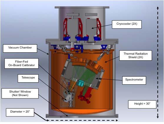
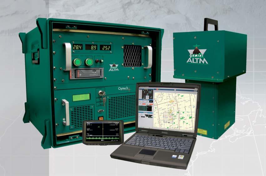
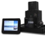
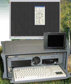
8 Payload Instrumentation Spectrometer design concept Optech ALTM Gemini system Applanix digital airborne camera Applanix GPS/IMU Nov 2009 NEON FDR 8

")
9 Integrated Payload camera spectrometer LiDAR Payload Integration mount (PIM) Nov 2009 NEON FDR 9
10 Sensor Data Products Level-0: raw sensor output data Level-1: geo-located, calibrated sensor data (1-3 meter res) Sensor spectral radiance: 380 to 2500 nm, 10 nm resolution Surface reflectance: 380 to 2500 nm, 10 nm resolution LiDAR vertical waveform Panchromatic imagery (15 to 30 cm resolution) Level-3: mapped 5-meter sensor data Surface reflectance: 380 to 2500 nm, 10 nm resolution nearest neighbor LiDAR waveform 5-meter averaged LIDAR waveform 50-cm resolution imagery (zoom to Level-1 resolution) Nov 2009 NEON FDR 10

11 AOP Sensor Technical Facility System Requirements Provide operations, logistics and support for sensor maintenance and operations [NEON.SYS.2.640] Provide the adequate facilities for calibration and validation of sensors [NEON.SYS.2.680] Calibration laboratory NIST traceable sources Special test sets & equipment Sensor support facilities repair and maintenance Supporting field equipment NIST Lamp Filter Wheel NI S PIM storage Spectralon Panel Nov 2009 NEON FDR 11
12 Project Interfaces Facilities and Civil Construction (FCC) FCC responsible for Technical Facility & AOP-specific floor plan AOP responsible for facility requirements, specification, and interior configuration Cyber-infrastructure (CI) Computing hardware, operational software implementation of algorithms Fundamental Sentinel Unit (FSU) Coordinated field sampling during commissioning Fundamental Instrument Unit (FIU) Provide atmospheric measurement data Data Products Group Higher level science data products derived from AOP level-1/-3 data Nov 2009 NEON FDR 12
13 AOP Operations Science Operations Flight operations planning & support Science data analysis, products and QA/QC External science community support Flight Operations Aviation safety Aircraft lease contract management Flight logistics, operations & field support Instrument Support Instrument calibration Instrument maintenance & repair Aircraft/payload integration Nov 2009 NEON FDR 13

14 Example Flight Operations 2 aircraft with identical payloads to cover sites 7-months, 1,100 flight hrs flight season 3 rd Payload for backup & new science, TOO s Ship payload to Hawaii AOP-2 Preseason calibration flight AOP-1 Nov 2009 NEON FDR 14
15 2.15 AOP - WBS WBS Title 2.15 Airborne Observation Platform (AOP) AOP Management AOP Commissioning AOP Sensor Field Commissioning AOP Calibration Lab Commissioning AOP Equipment AOP Spectrometer AOP Waveform Lidar AOP Integrated Payload AOP Sensor Support Facility Nov 2009 NEON FDR 15

16 2.15 AOP - FTE Spread by FY Nov 2009 NEON FDR 16
17 Page 1 TASK AOP Schedule 2.15 Airborne Observation Platform (AOP) Construction Phase Schedule JPL - Spectrometer Design Verification Unit (NIS DVU) NIS DVU Risk Reduction SRR Kickoff CDR / MRR Project Execution Plan Due Prelim SW Def. Comp. Test Flt #1 Integration Complete FRR Flt. #2 DVU Del. to NEON Test Flt. #2 DVU Reconfigured to NIS-3 Imaging Spectrometer (NIS) Waveform Altimeter Lidar (WALi) #1 Acc Test Del #1 #2 Acc Test WALi-1 Int w/eng Mt. Del #2 Proc/Fab #3 Acc Test Del #3 Int & Test #1 Acc Test Flights & Data Analysis TRR NIS1 Int & Test #2 Test & Cal - #1 #2 Test & Cal TRR #2 HRCR #1 & Del to NEON #2 HRCR & Del to NEON Payload Integration Eng. Mt Del to NEON Inst. Int. w/flt Mt #3 Flt. Mts Del Inst. Int. w/flt Mt #1 Inst. Int. w/flt Mt #2 Pay #1 Int w/plane Comp Pay #3 Int w/plane comp Pay #2 Int w/plane comp Nov 2009 NEON FDR 17
18 Page 2 TASK Commissioning Flight Payload # Airborne Observation Platform (AOP) Construction Phase Schedule Flight Val Sci-Ops Data Val Acc Rev Del to Ops Commissioning Flight Payload #2 Flight Val Sci Ops Data Val Acc Rev Del to Ops Commissioning Flight Payload #3 Flight Val Sci Ops Data Val Acc Rev Del to Ops AOP Facility Specs GSE Procs Test Set Dev Commissioning L2 Milestones Mount Assembly Mt. Assy PDR Mt. Assy FDR Flt. Mt. Delivery Lidar/Camera Build Progress Review WALi-1 Delivery WALi-2 Delivery WALi-3 Delivery Test Flights Test Flt #1 Complete Test Flt #2 Complete Test Flt #3 Complete Nov 2009 NEON FDR 18

19 AOP PT Risk Register High High Spectrometer Delays mitigation via NIS-DVU effort Fuel costs prioritize annual surveying Nov 2009 NEON FDR 19
20 Progress Since PDR Completed the JPL spectrometer risk reduction tasks ARRA funds awarded to begin spectrometer DVU development Updated risk mitigation plans Completed internal preliminary design review of the AOP sensor technical facility Established Calibration-Validation working group Addressed PDR recommendations Presented at and participated in science (ESA, LTER, NASA HyspIRI) and engineering (SPIE) conferences, USGS meeting at NEON HQ Nov 2009 NEON FDR 20
21 Work Over Next 12-months Spectrometer DVU Prototype algorithm development Early aircraft flights for operations and algorithm prototyping, and DVU testing Early AOP sensor technical facility development Prototype PIM design and fabrication Internal design reviews for instrumentation Refinement of AOP operations plan Mature calibration/validation plans and develop procedures Nov 2009 NEON FDR 21
22 Summary AOP will provide airborne remote sensing data at the local to regional scale bridging scales from organism and stand scale to scale of satellite remote sensing Three identical advanced instrumentation packages: spectrometer, waveform LIDAR and airborne camera Final baseline design and project plan are complete; mitigation of spectrometer and algorithm risks has begun AOP is ready to proceed to construction Nov 2009 NEON FDR 22

23 The National Ecological Observatory Network is a project sponsored by the National Science Foundation and managed under cooperative agreement by NEON Inc. Nov 2009 NEON FDR 23
IMAGING REFLECTANCE SPECTROSCOPY IN THE NATIONAL ECOLOGICAL OBSERVATORY NETWORK S AIRBORNE OBSERVATION PLATFORM
 IMAGING REFLECTANCE SPECTROSCOPY IN THE NATIONAL ECOLOGICAL OBSERVATORY NETWORK S AIRBORNE OBSERVATION PLATFORM David Schimel, Tom Kampe, Brian Johnson, and Michele Kuester NEON, Inc., Boulder, Colorado
ISIS TC Meeting. International Spaceborne Imaging Spectroscopy (ISIS) GRSS Technical Committee Meeting, 16/07/2014, IGARSS 2014
 GRSS Technical Committee Meeting, 16/07/2014, IGARSS 2014") ISIS TC Meeting International Spaceborne Imaging Spectroscopy (ISIS) GRSS Technical Committee Meeting, 16/07/2014, IGARSS 2014 Andreas Müller (DLR) Cindy Ong (CSIRO) Uta Heiden (DLR) Agenda Hyperspectral
ISIS TC Meeting International Spaceborne Imaging Spectroscopy (ISIS) GRSS Technical Committee Meeting, 16/07/2014, IGARSS 2014 Andreas Müller (DLR) Cindy Ong (CSIRO) Uta Heiden (DLR) Agenda Hyperspectral
ESA UNCLASSIFIED - For Official Use
 ESA UNCLASSIFIED - For Official Use A Hyperspectral Mission for Sentinel-2 Data Product Validation of a Northern Ombrotrophic Bog Soffer R. J., Arroyo-Mora J.P., Kalacska M., White, H.P., Ifimov G., Leblanc
Multispectral Scanners for Wildland Fire Assessment NASA Ames Research Center Earth Science Division. Bruce Coffland U.C.
 Multispectral Scanners for Wildland Fire Assessment NASA Earth Science Division Bruce Coffland U.C. Santa Cruz Slide Fire Burn Area (MASTER/B200) R 2.2um G 0.87um B 0.65um Airborne Science & Technology
Earth Observations from Space U.S. Geological Survey
 Earth Observations from Space U.S. Geological Survey Geography Land Remote Sensing Program Dr. Bryant Cramer April 1, 2009 U.S. Department of the Interior U.S. Geological Survey USGS Landsat Historical
PACE Science Definition Team Kickoff Meeting. Paula Bontempi, Betsy Edwards, Eric Ianson, Hal Maring, Woody
 PACE Science Definition Team Kickoff Meeting Paula Bontempi, Betsy Edwards, Eric Ianson, Hal Maring, Woody Turner NASA Headquarters PACE Program Science and Engineering 16-18 November 2011 PACE Mission
Sustained Ocean Color Research and Operations
 Sustained Ocean Color Research and Operations What are the minimum requirements to continue the SeaWiFS/MODIS time-series? Based on a National Research Council report by the Ocean Studies Board May 2011
FLIGHT SUMMARY REPORT
 FLIGHT SUMMARY REPORT Flight Number: 97-011 Calendar/Julian Date: 23 October 1996 297 Sensor Package: Area(s) Covered: Wild-Heerbrugg RC-10 Airborne Visible and Infrared Imaging Spectrometer (AVIRIS) Southern
Multiplatform Remote Sensing for Coral Reef Community Assessment
 Multiplatform Remote Sensing for Coral Reef Community Assessment Quinta Reunión Nacional de Percepción Remota y Sistemas de Información Geográfica en Puerto Rico September 27, 2007 Roy A. Armstrong, Ph.
NASA s Earth Science Technology Office CubeSats for Technology Maturation
 NASA s Earth Science Technology Office CubeSats for Technology Maturation Charles D. Norton NASA HQ Earth Science Technology Office (ESTO) Jet Propulsion Laboratory, California Institute of Technology
Design and Operation of Micro-Gravity Dynamics and Controls Laboratories
 Design and Operation of Micro-Gravity Dynamics and Controls Laboratories Georgia Institute of Technology Space Systems Engineering Conference Atlanta, GA GT-SSEC.F.4 Alvar Saenz-Otero David W. Miller MIT
Pre-Aerosol, Clouds, and ocean Ecosystem (PACE) Mission
 Mission") Pre-Aerosol, Clouds, and ocean Ecosystem (PACE) Mission Paula S. Bontempi, Program Scientist Betsy Edwards, Program Executive Hal Maring, Deputy Program Scientist Woody Turner, Program Applications Lead
Pre-Aerosol, Clouds, and ocean Ecosystem (PACE) Mission Paula S. Bontempi, Program Scientist Betsy Edwards, Program Executive Hal Maring, Deputy Program Scientist Woody Turner, Program Applications Lead
University Nanosat Program
 University Nanosat Program 04/19/2012 Integrity Service Excellence Lt Kelly Alexander UNP, DPM AFRL/RVEP Air Force Research Laboratory 1 Overview What is UNP Mission and Focus History and Competition Process
Technical Committee Report International Spaceborne Imaging Spectroscopy
 Slide 1 Geoscience and Remote Sensing Society Technical Committee Report International Spaceborne Imaging Spectroscopy Cindy Ong, CSIRO Andreas Mueller, DLR, Uta Heiden, DLR GRSS AdCom Meeting Washington,
Status of MODIS, VIIRS, and OLI Sensors
 Status of MODIS, VIIRS, and OLI Sensors Xiaoxiong (Jack) Xiong, Jim Butler, and Brian Markham Code 618.0 NASA/GSFC, Greenbelt, MD 20771, USA Acknowledgements: NASA MODIS Characterization Support Team (MCST)
Detection and Monitoring Through Remote Sensing....The Need For A New Remote Sensing Platform
 WILDFIRES Detection and Monitoring Through Remote Sensing...The Need For A New Remote Sensing Platform Peter Kimball ASEN 5235 Atmospheric Remote Sensing 5/1/03 1. Abstract This paper investigates the
Bridge Condition Assessment Using Remote Sensors
 A Summary of the 4th Quarterly Report for the Technical Activities Council Bridge Condition Assessment Using Remote Sensors Michigan Technological University USDOT Cooperative Agreement No. DTOS59-10-H-00001
On the use of water color missions for lakes in 2021
 Lakes and Climate: The Role of Remote Sensing June 01-02, 2017 On the use of water color missions for lakes in 2021 Cédric G. Fichot Department of Earth and Environment 1 Overview 1. Past and still-ongoing
The Hyperspectral UAV (HyUAV) a novel UAV-based spectroscopy tool for environmental monitoring
 a novel UAV-based spectroscopy tool for environmental monitoring") The Hyperspectral UAV (HyUAV) a novel UAV-based spectroscopy tool for environmental monitoring R. Garzonio 1, S. Cogliati 1, B. Di Mauro 1, A. Zanin 2, B. Tattarletti 2, F. Zacchello 2, P. Marras 2 and
The Hyperspectral UAV (HyUAV) a novel UAV-based spectroscopy tool for environmental monitoring R. Garzonio 1, S. Cogliati 1, B. Di Mauro 1, A. Zanin 2, B. Tattarletti 2, F. Zacchello 2, P. Marras 2 and
Typical Project Life Cycle
 Typical Project Life Cycle D. KANIPE 1/29/2015 Contract Initiation VISION REQUEST FOR INFORMATION REQUEST FOR PROPOSAL SOURCE EVALUATION BOARD RFI RFP Proposals Evaluated Companies Respond Companies Submit
Legacy of NOAA, NASA and NIST Cooperation in Developing Radiometric Calibration Standards Equipment and Methodologies. Raju Datla, Michael Weinreb
 Legacy of NOAA, NASA and NIST Cooperation in Developing Radiometric Calibration Standards Equipment and Methodologies CALCON 2012 Conference August 28, 2012 Raju Datla, Michael Weinreb Riverside Technology,
Japan's Greenhouse Gases Observation from Space
 1 Workshop on EC CEOS Priority on GHG Monitoring Japan's Greenhouse Gases Observation from Space 18 June, 2018@Ispra, Italy Masakatsu NAKAJIMA Japan Aerospace Exploration Agency Development and Operation
NASA Earth Science Activities Richard Eckman
 NASA Earth Science Activities Richard Eckman 19 February 2013 Outline On-orbit constellation overview Venture Class update Earth Science Division (ESD) Budget status Mission development status/plans ESD
ENMAP RADIOMETRIC INFLIGHT CALIBRATION, POST-LAUNCH PRODUCT VALIDATION, AND INSTRUMENT CHARACTERIZATION ACTIVITIES
 ENMAP RADIOMETRIC INFLIGHT CALIBRATION, POST-LAUNCH PRODUCT VALIDATION, AND INSTRUMENT CHARACTERIZATION ACTIVITIES A. Hollstein1, C. Rogass1, K. Segl1, L. Guanter1, M. Bachmann2, T. Storch2, R. Müller2,
Spectral compatibility of vegetation indices across sensors: band decomposition analysis with Hyperion data
 Journal of Applied Remote Sensing, Vol. 4, 043520 (30 March 2010) Spectral compatibility of vegetation indices across sensors: band decomposition analysis with Hyperion data Youngwook Kim,a Alfredo R.
3/31/03. ESM 266: Introduction 1. Observations from space. Remote Sensing: The Major Source for Large-Scale Environmental Information
 Remote Sensing: The Major Source for Large-Scale Environmental Information Jeff Dozier Observations from space Sun-synchronous polar orbits Global coverage, fixed crossing, repeat sampling Typical altitude
Ground Truth for Calibrating Optical Imagery to Reflectance
 Visual Information Solutions Ground Truth for Calibrating Optical Imagery to Reflectance The by: Thomas Harris Whitepaper Introduction: Atmospheric Effects on Optical Imagery Remote sensing of the Earth
Outline for today. Geography 411/611 Remote sensing: Principles and Applications. Remote sensing: RS for biogeochemical cycles
 Geography 411/611 Remote sensing: Principles and Applications Thomas Albright, Associate Professor Laboratory for Conservation Biogeography, Department of Geography & Program in Ecology, Evolution, & Conservation
Greg Mandt. AMS 90 th Annual Meeting 6th Annual Symposium on Future National Operational Environmental Satellite Systems NPOESS and GOES R
 An Overview of the GOES R Program Greg Mandt System Program Director AMS 90 th Annual Meeting 6th Annual Symposium on Future National Operational Environmental Satellite Systems NPOESS and GOES R January19
Textbook, Chapter 15 Textbook, Chapter 10 (only 10.6)
") AGOG 484/584/ APLN 551 Fall 2018 Concept definition Applications Instruments and platforms Techniques to process hyperspectral data A problem of mixed pixels and spectral unmixing Reading Textbook, Chapter
AGOG 484/584/ APLN 551 Fall 2018 Concept definition Applications Instruments and platforms Techniques to process hyperspectral data A problem of mixed pixels and spectral unmixing Reading Textbook, Chapter
Update on Landsat Program and Landsat Data Continuity Mission
 Update on Landsat Program and Landsat Data Continuity Mission Dr. Jeffrey Masek LDCM Deputy Project Scientist NASA GSFC, Code 923 November 21, 2002 Draft LDCM Implementation Phase RFP Overview Page 1 Celebrate!
2017 REMOTE SENSING EVENT TRAINING STRATEGIES 2016 SCIENCE OLYMPIAD COACHING ACADEMY CENTERVILLE, OH
 2017 REMOTE SENSING EVENT TRAINING STRATEGIES 2016 SCIENCE OLYMPIAD COACHING ACADEMY CENTERVILLE, OH This presentation was prepared using draft rules. There may be some changes in the final copy of the
746A27 Remote Sensing and GIS. Multi spectral, thermal and hyper spectral sensing and usage
 746A27 Remote Sensing and GIS Lecture 3 Multi spectral, thermal and hyper spectral sensing and usage Chandan Roy Guest Lecturer Department of Computer and Information Science Linköping University Multi
VICARIOUS CALIBRATION SITE SELECTION FOR RAZAKSAT MEDIUM-SIZED APERTURE CAMERA (MAC)
") VICARIOUS CALIBRATION SITE SELECTION FOR RAZAKSAT MEDIUM-SIZED APERTURE CAMERA (MAC) Lee Yee Hwai a, Mazlan Hashim b, Ahmad Sabirin Arshad a a Astronautic Technology (M) Sdn Bhd (yee_hwai, sabirin)@atsb.com.my
VICARIOUS CALIBRATION SITE SELECTION FOR RAZAKSAT MEDIUM-SIZED APERTURE CAMERA (MAC) Lee Yee Hwai a, Mazlan Hashim b, Ahmad Sabirin Arshad a a Astronautic Technology (M) Sdn Bhd (yee_hwai, sabirin)@atsb.com.my
NOAA Satellite and Information Service
 NOAA Satellite and Information Service Dr. Stephen Volz, Assistant Administrator NESDIS Program Overview and Decadal Survey Priorities ESAS2017 Steering Committee Meeting January 20, 2016 NOAA Satellite
R a d i o m e t r i c C a l i b r a t i o n N e t w o r k o f A u t o m a t e d I n s t r u m e n t s
 RadCalNet R a d i o m e t r i c C a l i b r a t i o n N e t w o r k o f A u t o m a t e d I n s t r u m e n t s Jeffrey Czapla-Myers* on behalf of the RadCalNet Working Group *Remote Sensing Group, College
REVIEW OF ENMAP SCIENTIFIC POTENTIAL AND PREPARATION PHASE
 REVIEW OF ENMAP SCIENTIFIC POTENTIAL AND PREPARATION PHASE H. Kaufmann 1, K. Segl 1, L. Guanter 1, S. Chabrillat 1, S. Hofer 2, H. Bach 3, P. Hostert 4, A. Mueller 5, and C. Chlebek 6 1 Helmholtz Centre
Copernicus Introduction Lisbon, Portugal 13 th & 14 th February 2014
 Copernicus Introduction Lisbon, Portugal 13 th & 14 th February 2014 Contents Introduction GMES Copernicus Six thematic areas Infrastructure Space data An introduction to Remote Sensing In-situ data Applications
Debrief of Dr. Whelan s TRL and Aerospace & R&D Risk Management. L. Waganer
 Debrief of Dr. Whelan s TRL and Aerospace & R&D Risk Management L. Waganer 21-22 January 2009 ARIES Project Meeting at UCSD Page 1 Purpose of TRL Briefings The TRL methodology was introduced to the ARIES
Passive Microwave Sensors LIDAR Remote Sensing Laser Altimetry. 28 April 2003
 Passive Microwave Sensors LIDAR Remote Sensing Laser Altimetry 28 April 2003 Outline Passive Microwave Radiometry Rayleigh-Jeans approximation Brightness temperature Emissivity and dielectric constant
Wind Imaging Spectrometer and Humidity-sounder (WISH): a Practical NPOESS P3I High-spatial Resolution Sensor
: a Practical NPOESS P3I High-spatial Resolution Sensor") Wind Imaging Spectrometer and Humidity-sounder (WISH): a Practical NPOESS P3I High-spatial Resolution Sensor Jeffery J. Puschell Raytheon Space and Airborne Systems, El Segundo, California Hung-Lung Huang
Wind Imaging Spectrometer and Humidity-sounder (WISH): a Practical NPOESS P3I High-spatial Resolution Sensor Jeffery J. Puschell Raytheon Space and Airborne Systems, El Segundo, California Hung-Lung Huang
From concept to launch of remote sensing satellites
 ENMAP Summer School on Remote Sensing Data Analysis From concept to launch of remote sensing satellites Roland Doerffer Retired from Helmholtz Zentrum Geesthacht Institute of Coastal Research Now: Brockmann
Results of J1 VIIRS testing using NIST s Traveling SIRCUS
 Results of J1 VIIRS testing using NIST s Traveling SIRCUS Steven W. Brown and Keith R. Lykke, NIST, Gaithersburg, MD Joel McCorkel, Brendan McAndrew, Gene Waluschka, and Jeff McIntire (Sigma Space), NASA
SHALOM: SPACEBORNE HYPERSPECTRAL APPLICATIVE LAND AND OCEAN MISSION: A JOINT PROJECT OF ASI-ISA AN UPDTAE FOR 2014
 SHALOM: SPACEBORNE HYPERSPECTRAL APPLICATIVE LAND AND OCEAN MISSION: A JOINT PROJECT OF ASI-ISA AN UPDTAE FOR 2014 Eyal Ben Dor Tel Aviv University Avia Kafri Israel Space Agency (ISA) Giancarlo Varacalli
Observing Nightlights from Space with TEMPO James L. Carr 1,Xiong Liu 2, Brian D. Baker 3 and Kelly Chance 2
 Observing Nightlights from Space with TEMPO James L. Carr 1,Xiong Liu 2, Brian D. Baker 3 and Kelly Chance 2 September 27, 2016 1 Carr Astronautics Corp., Greenbelt, MD, USA jcarr@carrastro.com 2 Harvard-Smithsonian
Satellite Imagery and Remote Sensing. DeeDee Whitaker SW Guilford High EES & Chemistry
 Satellite Imagery and Remote Sensing DeeDee Whitaker SW Guilford High EES & Chemistry whitakd@gcsnc.com Outline What is remote sensing? How does remote sensing work? What role does the electromagnetic
Earth-observing satellite intercomparison using the Radiometric Calibration Test Site at Railroad Valley
 Earth-observing satellite intercomparison using the Radiometric Calibration Test Site at Railroad Valley Jeffrey Czapla-Myers Joel McCorkel Nikolaus Anderson Stuart Biggar Jeffrey Czapla-Myers, Joel McCorkel,
Study of Chlorophyll-a Distribution of Microalgae at Tasik Aman and Tasik Harapan in Penang Island Malaysia using Landsat Image
 ISSN 2407-289 Study of Chlorophyll-a Distribution of Microalgae at Tasik Aman and Tasik Harapan in Penang Island Malaysia using Landsat Image a b c Fairooz Johan, Mohd Zubir Mat Jafri, Lim Hwee San,Wan
Introduction to Remote Sensing Fundamentals of Satellite Remote Sensing. Mads Olander Rasmussen
 Introduction to Remote Sensing Fundamentals of Satellite Remote Sensing Mads Olander Rasmussen (mora@dhi-gras.com) 01. Introduction to Remote Sensing DHI What is remote sensing? the art, science, and technology
From Proba-V to Proba-MVA
 From Proba-V to Proba-MVA Fabrizio Niro ESA Sensor Performances Products and Algorithm (SPPA) ESA UNCLASSIFIED - For Official Use Proba-V extension in the Copernicus era Proba-V was designed with the main
remote sensing? What are the remote sensing principles behind these Definition
 Introduction to remote sensing: Content (1/2) Definition: photogrammetry and remote sensing (PRS) Radiation sources: solar radiation (passive optical RS) earth emission (passive microwave or thermal infrared
CALMIT Field Program. Center for Advanced Land Management Information Technologies (CALMIT) University of Nebraska Lincoln
 University of Nebraska Lincoln") CALMIT Field Program Center for Advanced Land Management Information Technologies (CALMIT) University of Nebraska Lincoln Field Program: Three Areas Agriculture Surface Waters Coastal / Marine 1) Agriculture
CALMIT Field Program Center for Advanced Land Management Information Technologies (CALMIT) University of Nebraska Lincoln Field Program: Three Areas Agriculture Surface Waters Coastal / Marine 1) Agriculture
Evaluation of Sentinel-2 bands over the spectrum
 Evaluation of Sentinel-2 bands over the spectrum S.E. Hosseini Aria, M. Menenti, Geoscience and Remote sensing Department Delft University of Technology, Netherlands 1 outline ointroduction - Concept odata
Crop and Irrigation Water Management Using High-resolution Airborne Remote Sensing
 Crop and Irrigation Water Management Using High-resolution Airborne Remote Sensing Christopher M. U. Neale and Hari Jayanthi Dept. of Biological and Irrigation Eng. Utah State University & James L.Wright
National Aeronautics and Space Administration. Landsat Update. Jeff Masek, NASA GSFC Jim Irons, NASA GSFC. April 3, 2012 LCLUC Meeting.
 National Aeronautics and Space Administration Landsat Update Jeff Masek, NASA GSFC Jim Irons, NASA GSFC April 3, 2012 LCLUC Meeting www.nasa.gov Agenda Landsat-5/7 Update LDCM / Landsat-8 Mission Status
NON-PHOTOGRAPHIC SYSTEMS: Multispectral Scanners Medium and coarse resolution sensor comparisons: Landsat, SPOT, AVHRR and MODIS
 NON-PHOTOGRAPHIC SYSTEMS: Multispectral Scanners Medium and coarse resolution sensor comparisons: Landsat, SPOT, AVHRR and MODIS CLASSIFICATION OF NONPHOTOGRAPHIC REMOTE SENSORS PASSIVE ACTIVE DIGITAL
HYPERCUBE: Hyperspectral Imaging Using a CUBESAT
 HYPERCUBE: Hyperspectral Imaging Using a CUBESAT Ian S. Robinson Senior Engineering Fellow Raytheon Certified Architect Ian.Robinson@Raytheon.com Customer Success Is Our Mission Copyright 2011 Raytheon
Industry Day of the Copernicus Sentinel-5 and Jason-CS Projects
 Industry Day of the Copernicus Sentinel-5 and Jason-CS Projects With the present announcement, the European Space Agency and Astrium GmbH Satellites (Germany) inform the EMITS Users (European Companies
NASA and Earth Science Enterprise Overview
 NASA and Earth Science Enterprise Overview Presentation to Unidata Policy Committee 24 May 2004 H. Michael Goodman NASA hall Space Flight Center NASA s Vision and Mission Vision To improve life here, To
Transitioning Technology to Naval Ships. Dr. Norbert Doerry Technical Director, SEA 05 Technology Group SEA05TD
 Transitioning Technology to Naval Ships Transportation Research Board Public Meeting National Academy of Sciences June 10, 2010 Dr. Norbert Technical Director, SEA 05 Technology Group SEA05TD Norbert.doerry@navy.mil
The studies began when the Tiros satellites (1960) provided man s first synoptic view of the Earth s weather systems.
 provided man s first synoptic view of the Earth s weather systems.") Remote sensing of the Earth from orbital altitudes was recognized in the mid-1960 s as a potential technique for obtaining information important for the effective use and conservation of natural resources.
Remote sensing of the Earth from orbital altitudes was recognized in the mid-1960 s as a potential technique for obtaining information important for the effective use and conservation of natural resources.
Basic Hyperspectral Analysis Tutorial
 Basic Hyperspectral Analysis Tutorial This tutorial introduces you to visualization and interactive analysis tools for working with hyperspectral data. In this tutorial, you will: Analyze spectral profiles
Remote Sensing With Imaging Radar 1st Edition
 We have made it easy for you to find a PDF Ebooks without any digging. And by having access to our ebooks online or by storing it on your computer, you have convenient answers with remote sensing with
Project Title: Validation and Correction for the MODIS Spatial Response. NASA Grant #: NAG Period: October 1, May 31, 1999
 Project Title: Validation and Correction for the MODIS Spatial Response NASA Grant #: NAG5 6339 Period: October 1, 1997 - May 31, 1999 Robert A. Schowengerdt, Principal Investigator Stuart E. Biggar, Co
The COVE Payload A Reconfigurable FPGA-Based Processor for CubeSats
 The COVE Payload A Reconfigurable FPGA-Based Processor for CubeSats Paula Pingree Dmitriy Bekker Thomas Werne Thor Wilson Brian Franklin Jet Propulsion Laboratory August 8, 2010 Small Satellite Conference
Remote Sensing Phenology. Bradley Reed Principal Scientist USGS National Center for Earth Resources Observation and Science Sioux Falls, SD
 Remote Sensing Phenology Bradley Reed Principal Scientist USGS National Center for Earth Resources Observation and Science Sioux Falls, SD Remote Sensing Phenology Potential to provide wall-to-wall phenology
ABSTRACT. Keywords: ESSP, Earth Venture, program management, NASA Science Mission Directorate, Class-D mission, Instrument-first 1.
 SSC14-VI-10 Opportunities for Small Satellites in NASA s Earth System Science Pathfinder (ESSP) Program Frank Peri, Richard, C. Law, James E. Wells NASA Langley Research Center, 9 Langley Boulevard, Hampton,
HICO Status and Operations
 HICO Status and Operations HICO Users Group 7-8 May 2014 Mary Kappus, HICO Facility Manager Naval Research Laboratory Washington, DC HICO Transition to NASA Tech Demo Phase 1 In September 2009 HICO began
IKONOS High Resolution Multispectral Scanner Sensor Characteristics
 High Spatial Resolution and Hyperspectral Scanners IKONOS High Resolution Multispectral Scanner Sensor Characteristics Launch Date View Angle Orbit 24 September 1999 Vandenberg Air Force Base, California,
Aeolus Campaign Planning
 Aeolus Campaign Planning Dirk Schuettemeyer, Anne-Grete Straume, Thomas Kanitz, Alexander Geiss, Jonas v. Bismarck ESA UNCLASSIFIED - For Official Use Programmatic Background ESA campaign activities started
NASA Space Exploration 1 st Year Report
 Exploration Systems Mission Directorate NASA Space Exploration 1 st Year Report Rear Admiral Craig E. Steidle (Ret.) Associate Administrator January 31, 2005 The Vision for Space Exploration THE FUNDAMENTAL
Microwave Sensors Subgroup (MSSG) Report
 Report") Microwave Sensors Subgroup (MSSG) Report CEOS WGCV-35 May 13-17, 2013, Shanghai, China DONG, Xiaolong, MSSG Chair CAS Key Laboratory of Microwave Remote Sensing National Space Science Center Chinese Academy
Microwave Sensors Subgroup (MSSG) Report CEOS WGCV-35 May 13-17, 2013, Shanghai, China DONG, Xiaolong, MSSG Chair CAS Key Laboratory of Microwave Remote Sensing National Space Science Center Chinese Academy
Model-Based Design for Sensor Systems
 2009 The MathWorks, Inc. Model-Based Design for Sensor Systems Stephanie Kwan Applications Engineer Agenda Sensor Systems Overview System Level Design Challenges Components of Sensor Systems Sensor Characterization
Iridium NEXT SensorPODs: Global Access For Your Scientific Payloads
 Iridium NEXT SensorPODs: Global Access For Your Scientific Payloads 25 th Annual AIAA/USU Conference on Small Satellites August 9th 2011 Dr. Om P. Gupta Iridium Satellite LLC, McLean, VA, USA Iridium 1750
Visualizing a Pixel. Simulate a Sensor s View from Space. In this activity, you will:
 Simulate a Sensor s View from Space In this activity, you will: Measure and mark pixel boundaries Learn about spatial resolution, pixels, and satellite imagery Classify land cover types Gain exposure to
Microwave Sensors Subgroup (MSSG) Report
 Report") Microwave Sensors Subgroup (MSSG) Report Feb 17-20, 2014, ESA ESRIN, Frascati, Italy DONG, Xiaolong, MSSG Chair National Space Science Center Chinese Academy of Sciences (MiRS,NSSC,CAS) Email: dongxiaolong@mirslab.cn
Microwave Sensors Subgroup (MSSG) Report Feb 17-20, 2014, ESA ESRIN, Frascati, Italy DONG, Xiaolong, MSSG Chair National Space Science Center Chinese Academy of Sciences (MiRS,NSSC,CAS) Email: dongxiaolong@mirslab.cn
EXPERIENCE OF PARTICIPATION IN INTERNATIONAL SCIENTIFIC AND EDUCATIONAL SPACE PROJECTS BY THE EXAMPLE OF QB50 PROJECT
 EXPERIENCE OF PARTICIPATION IN INTERNATIONAL SCIENTIFIC AND EDUCATIONAL SPACE PROJECTS BY THE EXAMPLE OF QB50 PROJECT Postgraduate student of Inter-University Space Research Department Denis Davydov Samara,
CIRiS: Compact Infrared Radiometer in Space August, 2017
 1 CIRiS: Compact Infrared Radiometer in Space August, 2017 David Osterman PI, CIRiS Mission Presented by Hansford Cutlip 10/8/201 7 Overview of the CIRiS instrument and mission The CIRiS instrument is
SMEX04 Multispectral Radiometer Data: Arizona
 Notice to Data Users: The documentation for this data set was provided solely by the Principal Investigator(s) and was not further developed, thoroughly reviewed, or edited by NSIDC. Thus, support for
Preliminary Design Phase Activities, Priorities and Opportunities
 Preliminary Design Phase Activities, Priorities and Opportunities Massively multiplexed spectroscopy with MSE: Science, Project and Vision Kei Szeto MSE Project Office 28 February, 2019 Outline Overview
EARTH OBSERVATION WITH SMALL SATELLITES
 EARTH OBSERVATION WITH SMALL SATELLITES AT THE FUCHS-GRUPPE B. Penné, C. Tobehn, M. Kassebom, H. Lübberstedt OHB-System GmbH, Universitätsallee 27-29, D-28359 Bremen, Germany www.fuchs-gruppe.com ABSTRACT
Plan of Action. Juanjo Dañobeitia UTM-CSIC. OBS Meeting, Barcelona, 20 Sep 2010
 Plan of Action 2010-20132013 Juanjo Dañobeitia UTM-CSIC OBS Meeting, Barcelona, 20 Sep 2010 4.- Research lines (R+D+i) Marine Biosciences Marine geosciences Remote Sensing Technological Developing Engineering
Microwave Radiometers for Small Satellites
 Microwave Radiometers for Small Satellites Gregory Allan, Ayesha Hein, Zachary Lee, Weston Marlow, Kerri Cahoy MIT STAR Laboratory Daniel Cousins, William J. Blackwell MIT Lincoln Laboratory This work
Remote Sensing for Rangeland Applications
 Remote Sensing for Rangeland Applications Jay Angerer Ecological Training June 16, 2012 Remote Sensing The term "remote sensing," first used in the United States in the 1950s by Ms. Evelyn Pruitt of the
QUANTITATIVE GLOBAL MAPPING OF TERRESTRIAL VEGETATION PHOTOSYNTHESIS: THE FLUORESCENCE EXPLORER (FLEX) MISSION
 MISSION") 2017 IEEE International Geoscience and Remote Sensing Symposium July 23 28, 2017 Fort Worth, Texas, USA Session MO3.L12 - International Spaceborne Imaging Spectroscopy Missions: Updates and News I QUANTITATIVE
2017 IEEE International Geoscience and Remote Sensing Symposium July 23 28, 2017 Fort Worth, Texas, USA Session MO3.L12 - International Spaceborne Imaging Spectroscopy Missions: Updates and News I QUANTITATIVE
Phoenix. A 3U CubeSat to Study Urban Heat Islands. Sarah Rogers - Project Manager NASA Space Grant Symposium April 14, 2018
 Phoenix A 3U CubeSat to Study Urban Heat Islands Sarah Rogers - Project Manager NASA Space Grant Symposium April 14, 2018 Phoenix Overview Undergraduate-led 3U CubeSat to study Urban Heat Islands through
Govt. Engineering College Jhalawar Model Question Paper Subject- Remote Sensing & GIS
 Govt. Engineering College Jhalawar Model Question Paper Subject- Remote Sensing & GIS Time: Max. Marks: Q1. What is remote Sensing? Explain the basic components of a Remote Sensing system. Q2. What is
Blacksburg, VA July 24 th 30 th, 2010 Remote Sensing Page 1. A condensed overview. For our purposes
 A condensed overview George McLeod Prepared by: With support from: NSF DUE-0903270 in partnership with: Geospatial Technician Education Through Virginia s Community Colleges (GTEVCC) The art and science
NASA OBPG Satellite Ocean Color Update
 NASA OBPG Satellite Ocean Color Update Bryan Franz and the Ocean Biology Processing Group NASA Goddard Space Flight Center IOCS Meeting Ocean Color Research Team Meeting 18 May 2017, Lisbon, Portugal NASA
NASA Cost Symposium Multivariable Instrument Cost Model-TRL (MICM-TRL)
") NASA Cost Symposium Multivariable Instrument Cost Model-TRL (MICM-TRL) Byron Wong NASA Goddard Space Flight Center Resource Analysis Office (RAO) March 2, 2000 RAO Instrument Cost Model Drivers SICM (366
NASA Cost Symposium Multivariable Instrument Cost Model-TRL (MICM-TRL) Byron Wong NASA Goddard Space Flight Center Resource Analysis Office (RAO) March 2, 2000 RAO Instrument Cost Model Drivers SICM (366
NASA s Strategy for Enabling the Discovery, Access, and Use of Earth Science Data
 NASA s Strategy for Enabling the Discovery, Access, and Use of Earth Science Data Francis Lindsay, PhD Martha Maiden Science Mission Directorate NASA Headquarters IEEE International Geoscience and Remote
Aquarius Project, Spacecraft, Instrument and Data Processing Status
 Aquarius Project, Spacecraft, Instrument and Data Processing Status Gene Carl Feldman, Joel Gales, Liang Hong, Norman Kuring, Tommy Owens, Fred Patt, Alicia Scott, John Wilding Cal-Val Virtual Workshop
XMM-Newton Science Support, working together in support of the scientific community
 XMM-Newton Science Support, working together in support of the scientific community Maria Santos-Lleo With acknowledgement to the whole XMM-Newton Science Operations Centre at ESAC In this talk Introduction
Hyperspectral Systems: Recent Developments and Low Cost Sensors. 56th Photogrammetric Week in Stuttgart, September 11 to September 15, 2017
 Hyperspectral Systems: Recent Developments and Low Cost Sensors 56th Photogrammetric Week in Stuttgart, September 11 to September 15, 2017 Ralf Reulke Humboldt-Universität zu Berlin Institut für Informatik,
Inter-Calibration of the RapidEye Sensors with Landsat 8, Sentinel and SPOT
 Inter-Calibration of the RapidEye Sensors with Landsat 8, Sentinel and SPOT Dr. Andreas Brunn, Dr. Horst Weichelt, Dr. Rene Griesbach, Dr. Pablo Rosso Content About Planet Project Context (Purpose and
Michael Gaydar Deputy Director Air Platforms, Systems Engineering
 Michael Gaydar Deputy Director Air Platforms, Systems Engineering Early Systems Engineering Ground Rules Begins With MDD Decision Product Focused Approach Must Involve Engineers Requirements Stability
44 th CGMS, Biot France. New Era, System Capacity, Global Contribution, the Vision and Future of China Space
 44 th CGMS, Biot France New Era, System Capacity, Global Contribution, the Vision and Future of China Space China National Space Administration Wang Cheng, Jun 9 2016 Three Milestones of China s Space
Compact High Resolution Imaging Spectrometer (CHRIS) siraelectro-optics
 siraelectro-optics") Compact High Resolution Imaging Spectrometer (CHRIS) Mike Cutter (Mike_Cutter@siraeo.co.uk) Summary CHRIS Instrument Design Instrument Specification & Performance Operating Modes Calibration Plan Data
Compact High Resolution Imaging Spectrometer (CHRIS) Mike Cutter (Mike_Cutter@siraeo.co.uk) Summary CHRIS Instrument Design Instrument Specification & Performance Operating Modes Calibration Plan Data
Dr. P Shanmugam. Associate Professor Department of Ocean Engineering Indian Institute of Technology (IIT) Madras INDIA
 Madras INDIA") Dr. P Shanmugam Associate Professor Department of Ocean Engineering Indian Institute of Technology (IIT) Madras INDIA Biography Ph.D (Remote Sensing and Image Processing for Coastal Studies) - Anna University,
Dr. P Shanmugam Associate Professor Department of Ocean Engineering Indian Institute of Technology (IIT) Madras INDIA Biography Ph.D (Remote Sensing and Image Processing for Coastal Studies) - Anna University,
Zoltán Vekerdy Szent István Univ. János Tamás Debrecen University
 WATER PONDING IN HUNGARY: COLLECTION OF GROUND AND DRONE DATA GROUND REFLECTANCES Zoltán Vekerdy Szent István Univ. János Tamás Debrecen University 7th ADVANCED TRAINING COURSE ON LAND REMOTE SENSING 4