Satellite Oceanography and Monitoring for the Fishing Community
|
|
|
- Jerome Neal
- 5 years ago
- Views:
Transcription

1 Tuna 2012 Bangkok Satellite Oceanography and Monitoring for the Fishing Community Presentation by: Chris Wilson Marine Services
 Aerial (MJ Harden) St. Louis, Missouri Mission, Kansas 2010 Market Segments 6% 27% 67% U.S. Commercial Intl U.")

2 Who we are Imagery Collection satellite and aerial platforms GeoEye-1 IKONOS Production Services Herndon, Virginia - HQ Thornton, Colorado GeoEye-2 (2013) Aerial (MJ Harden) St. Louis, Missouri Mission, Kansas 2010 Market Segments 6% 27% 67% U.S. Commercial Intl U.S. Govt Information Services Imagery Dissemination Monitoring Services Employees: 740+ Publicly traded: NASDAQ: GEOY Content Services Web Services Worldwide Business Partner & Agent Network 78% 22% 2011 Revenue $356.4M Product & Other Imagery 2


3 Our Vision is to be the world s best source for location information and insight 3


4 GeoEye Constellation IKONOS m GeoEye m GeoEye m Over 400 miles high in orbit traveling 17,000 mph Industry leading resolution and positional accuracy MJ Harden Digital Mapping Camera & LiDAR sensors 2 inch Over 0.5 billion km 2 images in our archive Collection capacity of 7.5 million km 2 per month 4


5 Marine Services SeaStar Fisheries Information Service Tracking Solutions Other Support and Research related Projects 5


6 SeaStar Fisheries Information Service 6
 by collecting and processing data from several satellite systems.")
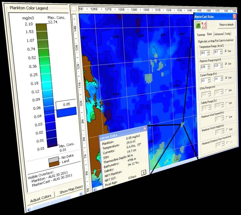
7 The SeaStar Service provides a wide assortment of oceanographic maps and weather information to help understand the fishing environment. GeoEye s Oceanographers produce fish finding maps (FFMs) by collecting and processing data from several satellite systems. The FFMs help users to identify productive fishing grounds-- saving search time and fuel expenses. 7
8 OrbMap Software - Advantages Designed for commercial pelagic fishermen, OrbMap software is easy to use, yet flexible. MasterCast quickly helps to locate preferred ocean conditions. Allows Captains to quickly integrate and compare many different satellite data sources to make smart fishing decisions. The Service is most effective when the Captain s knowledge is combined with satellite-observed ocean environmental information on board the vessel. 8


9 9

")
10 OBY-200 Buoy Advantages: Track your Fishing Gear with accurate GPS Fully compatible with OrbMap Inmarsat IsatM2M satellite network Two-way communications Sea surface temperature sensor High-intensity beacon for nighttime recovery Virtually awake and ready to respond to commands Fully compatible with Marine Satellite Receiver (MSR) 10


11 Equipped with 50KHz/500W echo sounder. Stealth design High Accuracy GPS Position Iridium Satellite Network SST Sensor Two-way communication Solar-cell charged batteries with alkaline battery backup Fully-integrated with OrbMap 30 minute Listening Windows High Intensity Recovery Beacon M3i Sonar Buoy 11


12 GeoEye partners with industry experts, Inmarsat and Honeywell Global Tracking, to bring you simple and inexpensive vessel position reports automatically. Provides accurate GPS Vessel Position Reports Two way communicating device, receives automatic positions and allows polling for real-time position Reports Inexpensive and easy to install yourself View maps in OrbMap or in Google Earth! Vessel tracks in Google Earth 12


13 Advantages: Intuitive, web-based tracking software. 2-way messaging and unit configuration. Global coverage over Inmarsat Satellites. Small and lightweight device. Emergency panic button. Display, keypad and Man Machine Interface (MMI). USB interface for charging and PC connection (NMEA data). Self contained unit with integral battery pack. Efficient power management, and long battery life Carried in wearable pouch, backpack pocket or invehicle cradle. 13


14 Web-based asset management tool Provides detailed mapping Allows remote configuring and managing of the tracking devices. 14
 and NOAA")
15 Ongoing Industry Support and Research Projects International Seafood Sustainability Foundation (ISSF) and the University of Hawaii Sponsorship to the 62nd Tuna Conference NOAA's Turtle Watch program University of Massachusetts (Amherst) and NOAA 15
16 Summary GeoEye provides satellite imagery and solutions for a number of applications, including fishing. The SeaStar Service provides valuable information to commercial fishing companies and other organizations that want to monitor the fishing grounds. GeoEye offers solutions for tracking and monitoring of vessels, buoys and personal around the world. We offer to participate in research projects that support the understanding of our oceans that we trust will benefit the health and longevity of the fishing industry. 16
17 Thank you
Satellite services and products for Automatic Weather Stations. Sophie Baudel
 Satellite services and products for Automatic Weather Stations Sophie Baudel sbaudel@cls.fr Share basic knowledge on telemetry services used by meteorologists and oceanographers for autonomous platforms
Proud supporter of the IRMF and the G4 - International Maritime Mass Rescue Conference
 Proud supporter of the IRMF and the G4 - International Maritime Mass Rescue Conference - 2017 Corporate Presentation 6/27/2017 1 OROLIA PROFILE $100m Founded in October 2006 in France, Head Office in Washington
Marine Monitor (M ) A Low Cost Radar Solution for Monitoring Nearshore Marine Protected Areas
 A Low Cost Radar Solution for Monitoring Nearshore Marine Protected Areas") 2 Marine Monitor (M ) A Low Cost Radar Solution for Monitoring Nearshore Marine Protected Areas 1 Problem The number of Marine Protected Areas (MPAs) are increasing globally making it challenging to effectively
2 Marine Monitor (M ) A Low Cost Radar Solution for Monitoring Nearshore Marine Protected Areas 1 Problem The number of Marine Protected Areas (MPAs) are increasing globally making it challenging to effectively
GMDSS for Recreational Boaters
 GMDSS for Recreational Boaters OVERVIEW The Global Maritime Distress and Safety System (GMDSS) is an international system using advanced communications technology. Development of GMDSS was initiated by
An Introduction to INDUSTRY PARTNERS 25/05/2017. Military Army & Air Force. Government Defense & Rescue. Aviation Maritime Military. Other.
 An Introduction to 1 INDUSTRY PARTNERS Aviation Maritime Military Coast Guard & Navy Military Army & Air Force Government Defense & Rescue Other Commercial Commercial/Workboat Navy Air Force SAR Agencies
Lecture 6: Multispectral Earth Resource Satellites. The University at Albany Fall 2018 Geography and Planning
 Lecture 6: Multispectral Earth Resource Satellites The University at Albany Fall 2018 Geography and Planning Outline SPOT program and other moderate resolution systems High resolution satellite systems
TECHNOLOGY DEVELOPMENT AREAS IN AAWA
 TECHNOLOGY DEVELOPMENT AREAS IN AAWA Technologies for realizing remote and autonomous ships exist. The task is to find the optimum way to combine them reliably and cost effecticely. Ship state definition
Automated Damage Analysis from Overhead Imagery
 Automated Damage Analysis from Overhead Imagery EVAN JONES ANDRE COLEMAN SHARI MATZNER Pacific Northwest National Laboratory 1 PNNL FY2015 at a Glance $955 million in R&D expenditures 4,400 scientists,
OPT Commercialization Update
 OPT Commercialization Update Forward Looking Statements In addition to historical information, this presentation contains forward-looking statements that are within the safe harbor provisions of the Private
Amateur Satellite and APRS Data Links. Polar Technology Conference April Bob Bruninga Midns: Kren, Aspholm
 Amateur Satellite and APRS Data Links Polar Technology Conference April 2012 Psat ODTML Ocean Buoys w/ RF Terminals GROUND STATION Bob Bruninga Midns: Kren, Aspholm US Naval Academy Satellite Lab 410-293-6417
Towards precision fishery: standardized modelling of smart services in the fishery domain
 Towards precision fishery: standardized modelling of smart services in the fishery domain Ståle Walderhaug Department for Software Engineering, Safety and Security SINTEF Digital Tromsø Norway stale.walderhaug@sintef.no
Satellite Imagery and Remote Sensing. DeeDee Whitaker SW Guilford High EES & Chemistry
 Satellite Imagery and Remote Sensing DeeDee Whitaker SW Guilford High EES & Chemistry whitakd@gcsnc.com Outline What is remote sensing? How does remote sensing work? What role does the electromagnetic
Digital Surveillance Devices?
 Technology Framework Tracking Technologies Don Mason Associate Director Digital Surveillance Devices? Digital Surveillance Devices? Secure Continuous Remote Alcohol Monitor SCRAM Page 1 Location Tracking
Ocean Observations Erik Buch EuroGOOS chair
 EB1 EB2 Ocean Observations Erik Buch EuroGOOS chair 15-07-2015 EuroGOOS AISBL eurogoos@eurogoos.eu - http://www.eurogoos.eu 1 Slide 1 EB1 Erik Buch, 2/26/2014 EB2 Erik Buch, 2/26/2014 Maritime activities
Digital surveillance devices?
 Technology Framework Tracking Technologies Don Mason Associate Director Copyright 2011 National Center for Justice and the Rule of Law All Rights Reserved Digital surveillance devices? Digital surveillance
The Future of Search & Rescue. We Save Lives. Steve Waters SAFE Symposium 2016
 The Future of Search & Rescue We Save Lives Steve Waters SAFE Symposium 2016 Covering today.. Understanding the Search and Rescue Ecosystem Helios and GADSS Global Aeronautical Distress and Safety System
Debris Detection: Background, Efforts, & Lessons Learned. Peter Murphy Alaska Coordinator / Detection Lead NOAA Marine Debris Program
 Debris Detection: Background, Efforts, & Lessons Learned Peter Murphy Alaska Coordinator / Detection Lead NOAA Marine Debris Program Outline Marine Debris Issue Types Distribution Impacts NOAA Marine Debris
Introduction to Remote Sensing Fundamentals of Satellite Remote Sensing. Mads Olander Rasmussen
 Introduction to Remote Sensing Fundamentals of Satellite Remote Sensing Mads Olander Rasmussen (mora@dhi-gras.com) 01. Introduction to Remote Sensing DHI What is remote sensing? the art, science, and technology
SAFE TO SEA (S2S) FOR THE SAFETY OF NAVIGTION.
 FOR THE SAFETY OF NAVIGTION.") SAFE TO SEA (S2S) FOR THE SAFETY OF NAVIGTION. GRAFINTA.S.A. Company founded in 1964 and located in Madrid. With 11 people on our payroll from which 8 are engineers specialized in new technologies and
SAFE TO SEA (S2S) FOR THE SAFETY OF NAVIGTION. GRAFINTA.S.A. Company founded in 1964 and located in Madrid. With 11 people on our payroll from which 8 are engineers specialized in new technologies and
TRACKING. ABOVE GROUND MARKER Pg RECEIVERS Pg TRANSMITTERS Pg. 8-3 to 8-5. GEOPHONE Pg DELRIN CANS Pg RENTALS Pg.
 RECEIVERS Pg. 8-2 ABOVE GROUND MARKER Pg. 8-7 TRANSMITTERS Pg. 8-3 to 8-5 GEOPHONE Pg. 8-8 DELRIN CANS Pg. 8-6 RENTALS Pg. 8-9 8-1 8-2 TRACKING RECEIVERS TRAXALL 500 & 501 The TRAXALL 500 and TRAXALL 501
Wireless Revolution in EcoTourism Education. Cape May, January 23, 2007
 Wireless Revolution in EcoTourism Education Cape May, January 23, 2007 1 2 Survey of us.. What is our digital profile Raise hands in the last five days. + Made a cell phone call: Yes / No + Sent an IM
Using satellite technology to monitor illegal, unreported, and unregulated (IUU) fishing
 fishing") Using satellite technology to monitor illegal, unreported, and unregulated (IUU) fishing Mark Richardson The Pew Charitable Trusts Blue Planet Symposium, June 2, 2017 The global threat of IUU fishing Illegal,
Using satellite technology to monitor illegal, unreported, and unregulated (IUU) fishing Mark Richardson The Pew Charitable Trusts Blue Planet Symposium, June 2, 2017 The global threat of IUU fishing Illegal,
Emergency Marine Communications
 Emergency Marine Communications Presented by: Steve Chamberlin Content:Chuck Hawley Safety at Sea Seminar US Sailing Goals of Emergency Communications To alert rescue services to your situation To get
Guide to Inductive Moorings
 Guide to Inductive Moorings Real-Time Ocean Observing Systems with Inductive Modem Telemetry Technology Visit Us at sea-birdscientific.com Reach us at info@seabird.com Copyright 2016 Sea-Bird Scientific
Govt. Engineering College Jhalawar Model Question Paper Subject- Remote Sensing & GIS
 Govt. Engineering College Jhalawar Model Question Paper Subject- Remote Sensing & GIS Time: Max. Marks: Q1. What is remote Sensing? Explain the basic components of a Remote Sensing system. Q2. What is
Part 1. Tracing the Dimensions of Some Common Pixel Sizes using a GPS Receiver
 Field and Laboratory Exercise PIXEL DELINEATIONS 1 IMPORTING GPS DATA TO IMAGE BACKGROUND Objectives: 1. Demonstrate the differences in spatial resolution of selected remote sensing instruments. 2. Use
EIS - Electronics Instrumentation Systems for Marine Applications
 Coordinating unit: Teaching unit: Academic year: Degree: ECTS credits: 2015 230 - ETSETB - Barcelona School of Telecommunications Engineering 710 - EEL - Department of Electronic Engineering MASTER'S DEGREE
Ozobot Bit. Computer Science Engineering Program
 3 rd Grade Ozobot Bit Computer Science Engineering Program Post Visit Activity Resources 2018 Winter/Spring 2018 Dear Third Grade Visiting Classroom Teacher, It is hoped that you and your students enjoyed
08/10/2013. Marine Positioning Systems Surface and Underwater Positioning. egm502 seafloor mapping
 egm502 seafloor mapping lecture 8 navigation and positioning Marine Positioning Systems Surface and Underwater Positioning All observations at sea need to be related to a geographical position. To precisely
The Ability of a Small Satellite Constellation to Tip and Cue Other Commercial Assets
 Changing the economics of space The Ability of a Small Satellite Constellation to Tip and Cue Other Commercial Assets Becky Cudzilo - Surrey Satellite US, LLC K.C. Foley - GeoEye, Inc. Chandler Smith -
Satellite Fleet for a Commercial Remote Sensing Company
 Satellite Fleet for a Commercial Remote Sensing Company Application Portfolio Danielle Wood December 5, 2007 Danielle Wood Page 1 of 16 December 5, 2007 Abstract This study considers the impacts of uncertainty
Satellites and autonomous robots: The future for Arctic observations
 Satellites and autonomous robots: The future for Arctic observations Jeremy Wilkinson British Antarctic Survey jpw28@bas.ac.uk Polarforskningskonferencen 2016 DTU, Oticon Salen, Anker Engelunds Vej 1,
Port Security and Technology - the U.S. Perspective. Michael S. Bruno Stevens Institute of Technology March 14, 2012
 Port Security and Technology - the U.S. Perspective Michael S. Bruno Stevens Institute of Technology March 14, 2012 CSR A Department of Homeland Security National Center of Excellence for Port Security
第 XVII 部 災害時における情報通信基盤の開発
 XVII W I D E P R O J E C T 17 1 LifeLine Station (LLS) WG LifeLine Station (LLS) WG was launched in 2008 aiming for designing and developing an architecture of an information package for post-disaster
Coastal Surveillance. SCANTER Radar Solutions
 Coastal Surveillance SCANTER Radar Solutions Protecting Your Coastlines and Maritime Domain We provide radar coverage of the coastline to detect and track all types of surface vessels and air targets.
Transparency in the Western and Central Pacific Tuna Longline Fishery Enhancing verifiability with electronic reporting and monitoring
 A brief from July 2016 Michael Crispino Transparency in the Western and Central Pacific Tuna Longline Fishery Enhancing verifiability with electronic reporting and monitoring Overview Tuna longline fisheries
Linemaster Marine Electronics. Sky Technologies MARINE SERVICES AGENTS APAC
 MARINE SERVICES AGENTS APAC Linemaster Marine Electronics Linemaster was founded in 1992. The result of an idea to create a product to aid in the deployment of Longlines. Today the Linemaster Longline
International Fisheries Observer Conference
 International Fisheries Observer Conference Howard McElderry Overview History of conference series Gearing up for IFOC07 2007 Conference in brief Thoughts toward IFOC09 1 Conference History Galveston,
HARRIS GEOSPATIAL MARKETPLACE. HarrisGeospatial.com
 HARRIS GEOSPATIAL MARKETPLACE HarrisGeospatial.com Satellite image of Washington, D.C. Image courtesy of DigitalGlobe GET IT ALL IN ONE PLACE Data for Any Project Map Products Vis/Sim Products Geospatial
Antennas & Antenna Assemblies
 Antennas & Antenna Assemblies COMPANY SNAPSHOT Dominant technology provider of RF/microwave, microelectronics, and security products for critical and high-reliability applications Deliver high performance,
Kongsberg Satellite Services, KSAT
 SvalSat, Earth Station at 78 North Kongsberg Satellite Services, KSAT Making Sense of Space Sigmund Dehli International Sales Manager WORLD CLASS through people, technology and dedication My plan KSAT
Development of Microsatellite to Detect Illegal Fishing MS-SAT
 Development of Microsatellite to Detect Illegal Fishing MS-SAT Ernest S. C. P. Bintang A.S.W.A.M. Department of Aerospace Engineering Faculty of Mechanical and Aerospace Engineering Institut Teknologi
Distributed Awareness: Portable Unmanned Maritime Systems. Bruce Hanson Maritime Tactical Systems May 4, 2015
 Distributed Awareness: Portable Unmanned Maritime Systems Bruce Hanson Maritime Tactical Systems May 4, 2015 Introduction This unmanned conference exists because of the ratio of computing power to the
CGMS-37, NOAA-WP-33 Prepared by NOAA Agenda Item: IV/1 Discussed in WG IV
 Prepared by NOAA Agenda Item: IV/1 Discussed in WG IV NOAA-WP-33 provides a status of its Geostationary Operational Environmental Satellite Series R (GOES-R). and polar-orbiting satellite constellations.
Recent Developments in NOAA s Real- Time Coastal Observing Systems for Safe and Efficient Maritime Transportation
 Recent Developments in NOAA s Real- Time Coastal Observing Systems for Safe and Efficient Maritime Transportation Rich Edwing, Director NOAA Center for Operational Oceanographic Products and Services CMTS
European Space Imaging
 European Space Imaging Use cases of Very High Resolution satellite imagery in support of crop management GEO-CRADLE Regional Workshop, 7/12/2017, Tunis Arnaud Durand adurand@euspaceimaging.com COMPANY
ORBCOMM Machine-To-Machine (M2M)
") ORBCOMM Machine-To-Machine (M2M) Texas V & C-Sigma November 2012 Global M2M Connecting the World s Assets Machine-To-Machine (M2M) Applications Global M2M Wireless Network for Narrowband Data Applications
ORBCOMM Machine-To-Machine (M2M) Texas V & C-Sigma November 2012 Global M2M Connecting the World s Assets Machine-To-Machine (M2M) Applications Global M2M Wireless Network for Narrowband Data Applications
WILDLIFE MONITORING WITH ARGOS by Christian Ortega. Zoology & Satellite Seminar IPEE ASR, Moscou February 2009
 WILDLIFE MONITORING WITH ARGOS by Christian Ortega Zoology & Satellite Seminar IPEE ASR, Moscou 25-26 February 2009 WILDLIFE AND ARGOS Authorizations in Russia (customs, transmission) Tags (choice, testing,
Short and Long Term Partnering Strategies for Improving Communications/Disseminatio ns for Pacific Island NMHSs
 Short and Long Term Partnering Strategies for Improving Communications/Disseminatio ns for Pacific Island NMHSs Edward H. Young, Jr. NOAA National Weather Service Pacific Region RANET Pacific Steering
HIGH IMPACT INNOVATIONS TRANSFORMING AUSTRALIAN AGRICULTURE
 NATIONAL RURAL ISSUES HIGH IMPACT INNOVATIONS TRANSFORMING AUSTRALIAN AGRICULTURE Horizon Scan Agriculture is being transformed by technologies that have the capacity to make the entire agricultural supply
USNA-0601 ParkinsonSAT Remote Data Relay (Psat) Cubesat Conference Aug 2012
 Cubesat Conference Aug 2012") USNA-0601 ParkinsonSAT Remote Data Relay (Psat) Cubesat Conference Aug 2012 Psat BRICsat Ocean Buoys w/ RF Terminals GROUND STATION Data Exfiltration Bob Bruninga Midns: Buck, Kimball, Lung, Mahelik, Rehume,
USNA-0601 ParkinsonSAT Remote Data Relay (Psat) Cubesat Conference Aug 2012 Psat BRICsat Ocean Buoys w/ RF Terminals GROUND STATION Data Exfiltration Bob Bruninga Midns: Buck, Kimball, Lung, Mahelik, Rehume,
OIL SPILLS IN ICE Remote Sensing
 OIL SPILLS IN ICE Remote Sensing Technology Overview and Upcoming JIP Research David Dickins Chevron IOSC2014 Savannah COLLABORATION AMONG TEN COMPANIES International arctic research programme Builds upon
MSRC Tactical Oil Spill Surveillance and Remote Sensing
 MSRC Tactical Oil Spill Surveillance and Remote Sensing Industry Technical Advisory Committee for Oil spill Response October 25, 2016 0 Historical Perspective -- Oil Spill Surveillance in U.S Exxon Valdez
Problem. How we solve the problem.
 Humanitarian agencies need to trust their personnel are safe and secure at all times. A long range digital radio solution provides reliable voice and data communications for workers in the field, ensuring
NOAA Satellite Observing System Architecture (NSOSA) Study Update
 Study Update") NOAA Satellite Observing System Architecture (NSOSA) Study Update Dr. Karen St. Germain Director NOAA/NESDIS Office of System Architecture and Advanced Planning (OSAAP) Spring 2017 Meeting of the Committee
NOAA Satellite Observing System Architecture (NSOSA) Study Update Dr. Karen St. Germain Director NOAA/NESDIS Office of System Architecture and Advanced Planning (OSAAP) Spring 2017 Meeting of the Committee
NON-PHOTOGRAPHIC SYSTEMS: Multispectral Scanners Medium and coarse resolution sensor comparisons: Landsat, SPOT, AVHRR and MODIS
 NON-PHOTOGRAPHIC SYSTEMS: Multispectral Scanners Medium and coarse resolution sensor comparisons: Landsat, SPOT, AVHRR and MODIS CLASSIFICATION OF NONPHOTOGRAPHIC REMOTE SENSORS PASSIVE ACTIVE DIGITAL
Iridium NEXT SensorPODs: Global Access For Your Scientific Payloads
 Iridium NEXT SensorPODs: Global Access For Your Scientific Payloads 25 th Annual AIAA/USU Conference on Small Satellites August 9th 2011 Dr. Om P. Gupta Iridium Satellite LLC, McLean, VA, USA Iridium 1750
Customer Showcase > Defense and Intelligence
 Customer Showcase Skyline TerraExplorer is a critical visualization technology broadly deployed in defense and intelligence, public safety and security, 3D geoportals, and urban planning markets. It fuses
LT Matthew Forney, NOAA Navigation Manager Alaska Region Bering Strait MaritimeSymposium. Office of Coast Survey
 NOAA LT Matthew Forney, NOAA Navigation Manager Alaska Region Bering Strait MaritimeSymposium Who is Coast Survey? First science agency of the U.S. Formed in 1807 Responsible for surveying 3.4 million
The studies began when the Tiros satellites (1960) provided man s first synoptic view of the Earth s weather systems.
 provided man s first synoptic view of the Earth s weather systems.") Remote sensing of the Earth from orbital altitudes was recognized in the mid-1960 s as a potential technique for obtaining information important for the effective use and conservation of natural resources.
Remote sensing of the Earth from orbital altitudes was recognized in the mid-1960 s as a potential technique for obtaining information important for the effective use and conservation of natural resources.
Solutions for a blue planet
 Solutions for a blue planet Optimising the businesses of offshore and shallow water professionals with sustainability as our beacon The world is seeing a steady increase in operations at sea in the energy,
Satellite data for Maritime Operations. Andreas Hay Kaljord Project Manager Energy, Environment & Security
 Satellite data for Maritime Operations Andreas Hay Kaljord Project Manager Energy, Environment & Security Kongsberg Satellite Services (KSAT) World leading provider within our business area Supports 85
Author s Name Name of the Paper Session. DYNAMIC POSITIONING CONFERENCE October 10-11, 2017 SENSORS SESSION. Sensing Autonomy.
 Author s Name Name of the Paper Session DYNAMIC POSITIONING CONFERENCE October 10-11, 2017 SENSORS SESSION Sensing Autonomy By Arne Rinnan Kongsberg Seatex AS Abstract A certain level of autonomy is already
Lecture 1 Introduction to Remote Sensing
 Lecture 1 Introduction to Remote Sensing Dr Ian Leiper School of Environmental and Life Sciences Bldg Purple 12.2.27 1 2 Lecture Outline Introductions Unit admin Learning outcomes Unit outline Practicals
PEGASUS : a future tool for providing near real-time high resolution data for disaster management. Lewyckyj Nicolas
 PEGASUS : a future tool for providing near real-time high resolution data for disaster management Lewyckyj Nicolas nicolas.lewyckyj@vito.be http://www.pegasus4europe.com Overview Vito in a nutshell GI
AIREON SPACE-BASED ADS-B
 AIREON SPACE-BASED ADS-B 2018 Transport Canada Delegates Conference Steve Bellingham Manager, Navigation Systems Engineering Steve.Bellingham@navcanada.ca CNS/ATM Systems Communication Navigation Surveillance
A Space-Based Solution for Illegal, Unregulated & Unreported Fishing. Emmanouil Detsis, International Space University
 Project Catch A Space-Based Solution for Illegal, Unregulated & Unreported Fishing Emmanouil Detsis, International Space University Project Catch COPUOS Presentation Team Project Oceans International Intercultural
TechDemoSat-1 & NovaSAR-S
 TechDemoSat-1 & NovaSAR-S Lily Dodemant / Peter Fletcher UKSA Ground Segment Team 6th June 2012 http://www.bis.gov.uk/ukspaceagency TechDemoSat-1 Objectives A technology demonstration satellite project
The world s most advanced constellation
 The DigitalGlobe Constellation The world s most advanced constellation of very high-resolution satellites The world s most advanced constellation The DigitalGlobe constellation of high-resolution satellites
TOURISM INSIGHT FRAMEWORK GENERATING KNOWLEDGE TO SUPPORT SUSTAINABLE TOURISM. IMAGE CREDIT: Miles Holden
 TOURISM INSIGHT FRAMEWORK GENERATING KNOWLEDGE TO SUPPORT SUSTAINABLE TOURISM IMAGE CREDIT: Miles Holden Prioritise insight to generate knowledge Insight is the lifeblood of the New Zealand tourism industry.
An Introduction to Airline Communication Types
 AN INTEL COMPANY An Introduction to Airline Communication Types By Chip Downing, Senior Director, Aerospace & Defense WHEN IT MATTERS, IT RUNS ON WIND RIVER EXECUTIVE SUMMARY Today s global airliners use
Satellite Technologies for Fisheries Monitoring, Control and Surveillance (MCS)
") JRC IPSC Maritime Affairs 1 Satellite Technologies for Fisheries Monitoring, Control and Surveillance (MCS) Juan Cicuendez, Marlene Alvarez JRC Info Day Madrid, 2 June 2010 IPSC - Institute for the Protection
JRC IPSC Maritime Affairs 1 Satellite Technologies for Fisheries Monitoring, Control and Surveillance (MCS) Juan Cicuendez, Marlene Alvarez JRC Info Day Madrid, 2 June 2010 IPSC - Institute for the Protection
ScreenMaster RVG200 Paperless recorder
 ABB MEASUREMENT & ANALYTICS TECHNICAL DESCRIPTION ScreenMaster RVG200 Paperless recorder Programming the RVG200 to record GPS data in bilge water discharge monitoring applications Measurement made easy
Anna Marie Seafood P.O. Box 141 Dulac, LA Phone: Web:
 Anna Marie Seafood P.O. Box 141 Dulac, LA 70353 Phone: 985.209.2862 Web: www.annamarieseafood.com Email: annamarieseafood@charter.net February 4, 2010 To Whom It May Concern: I became a customer of Integrated
NOAA Satellite and Information Service
 NOAA Satellite and Information Service Dr. Stephen Volz, Assistant Administrator NESDIS Program Overview and Decadal Survey Priorities ESAS2017 Steering Committee Meeting January 20, 2016 NOAA Satellite
ACR Electronics, Inc Ravenswood Road Fort Lauderdale, FL New Product Briefing SARLink 406 MHz / Iridium Beacon
 ACR Electronics, Inc. 5757 Ravenswood Road Fort Lauderdale, FL 33312 www.acrartex.com New Product Briefing SARLink 406 MHz / Iridium Beacon Two Powerful Brands One Great Company Our Brands Marine, Aviation,
COMMUNICATIONS FOR MARITIME SAFETY AND EFFICIENCY. Francis Zachariae, Secretary-General, IALA
 COMMUNICATIONS FOR MARITIME SAFETY AND EFFICIENCY Francis Zachariae, Secretary-General, IALA IALA and its Purpose Non profit, international technical association established in 1957 Two Goals aimed at
Earth Observations from Space U.S. Geological Survey
 Earth Observations from Space U.S. Geological Survey Geography Land Remote Sensing Program Dr. Bryant Cramer April 1, 2009 U.S. Department of the Interior U.S. Geological Survey USGS Landsat Historical
GPSMAP 700 series owner s manual
 GPSMAP 700 series owner s manual Introduction Introduction WARNING See the Important Safety and Product Information guide in the product box for product warnings and other important information. This manual
CANADA S OCEAN SUPERCLUSTER DRAFT NOVEMBER 1
 CANADA S OCEAN SUPERCLUSTER AGENDA 01 What is the Ocean Supercluster? 02 What is the opportunity for business? 03 What is the opportunity for Canada? 04 How will the Ocean Supercluster work? 05 What are
Radiocommunications and climate changes
 Radiocommunications and climate changes Durban, South Africa 1 December 2011 COP-17 Vadim Nozdrin, Counselor, ITU-R Study Group 7 Study Group Department Radiocommunication Bureau
MONITORING SEA LEVEL USING GPS
 38 MONITORING SEA LEVEL USING GPS Hasanuddin Z. Abidin* Abstract GPS (Global Positioning System) is a passive, all-weather satellite-based navigation and positioning system, which is designed to provide
Long-term Acoustic Real-Time Sensor for Polar Areas (LARA)
") DISTRIBUTION STATEMENT A. Approved for public release; distribution is unlimited. Long-term Acoustic Real-Time Sensor for Polar Areas (LARA) Holger Klinck, Haru Matsumoto, David K. Mellinger, and Robert
DISTRIBUTION STATEMENT A. Approved for public release; distribution is unlimited. Long-term Acoustic Real-Time Sensor for Polar Areas (LARA) Holger Klinck, Haru Matsumoto, David K. Mellinger, and Robert
ENAiKOON inmarsat-600
 -600 Inmarsat modem for worldwide satellite communication -600 enables communication between trackables and the back-end system through satellite communication. -600 was designed specifically for fleet
Overview of the global GNSS market and status of Galileo
 2012 GNSS.asia workshop Overview of the global GNSS market and status of Galileo 6 November, 2012 Taipei Justyna Redelkiewicz, European GNSS Agency European GNNS Agency supports European Commission in
NASA Search and Rescue Cospas-Sarsat MEOSAR, Second Generation Beacons, and DF Receiver with UAS March 23, 2017
 NASA Search and Rescue Cospas-Sarsat MEOSAR, Second Generation Beacons, and DF Receiver with UAS March 23, 2017 Dr. Lisa Mazzuca Mission Manager NASA Search and Rescue Office Goddard Space Flight Center
Analysis of Argos 3 Technology on Buoy Platforms. By L. Braasch, L. Centurioni, C. McCall Scripps Institution of Oceanography, La Jolla, California
 Analysis of Argos 3 Technology on Buoy Platforms By L. Braasch, L. Centurioni, C. McCall Scripps Institution of Oceanography, La Jolla, California Purpose of Study Controlled tests with same host controller
CubeSat Integration into the Space Situational Awareness Architecture
 CubeSat Integration into the Space Situational Awareness Architecture Keith Morris, Chris Rice, Mark Wolfson Lockheed Martin Space Systems Company 12257 S. Wadsworth Blvd. Mailstop S6040 Littleton, CO
(updates from last Plenary) AS Kiran Kumar ISRO, INDIA
 AS Kiran Kumar ISRO, INDIA") ISRO s EARTH OBSERVATION SYSTEM (updates from last Plenary) AS Kiran Kumar ISRO, INDIA The 24 th CEOS Plenary Rio de Janeiro, Brazil 12 15 October, 2010 1 Four Decades of Indian Space Programme 30 LV Missions
ISRO s EARTH OBSERVATION SYSTEM (updates from last Plenary) AS Kiran Kumar ISRO, INDIA The 24 th CEOS Plenary Rio de Janeiro, Brazil 12 15 October, 2010 1 Four Decades of Indian Space Programme 30 LV Missions
NASA MOBLAS 4. Goddard Space Flight Center Greenbelt, MD
 Annual HPWREN Users Meeting NASA MOBLAS 4 Goddard Space Flight Center Greenbelt, MD November 19, 2008 Howard Donovan Engineering and Operations Manager Ron Sebeny MOBLAS 4 Acting Station Manager NASA Satellite
The Future in Marine Radio Communication GMDSS. Department of Transportation United States Coast Guard
 The Future in Marine Radio Communication GMDSS Department of Transportation United States Coast Guard Do you use a Maritime Radio System? If so, the new Global Maritime Distress and Safety System (GMDSS)
Sources of Geographic Information
 Sources of Geographic Information Data properties: Spatial data, i.e. data that are associated with geographic locations Data format: digital (analog data for traditional paper maps) Data Inputs: sampled
XSAT Ground Segment at CRISP
 XSAT Ground Segment at CRISP LIEW Soo Chin Head of Research, CRISP http://www.crisp.nus.edu.sg 5 th JPTM for Sentinel Asia Step-2, 14-16 Nov 2012, Daejeon, Korea Centre for Remote Imaging, Sensing and
ITU Radiocommunication Sector (ITU-R) and Climate Change. Alexandre VASSILIEV ITU Radiocommunication Bureau
 and Climate Change. Alexandre VASSILIEV ITU Radiocommunication Bureau") ITU Radiocommunication Sector (ITU-R) and Climate Change Alexandre VASSILIEV ITU Radiocommunication Bureau WSIS FORUM 2009, Geneva, 18-22 May 2009 Radio and Information Society Today radio technologies
ITU Radiocommunication Sector (ITU-R) and Climate Change Alexandre VASSILIEV ITU Radiocommunication Bureau WSIS FORUM 2009, Geneva, 18-22 May 2009 Radio and Information Society Today radio technologies
Chapter 8. Remote sensing
 1. Remote sensing 8.1 Introduction 8.2 Remote sensing 8.3 Resolution 8.4 Landsat 8.5 Geostationary satellites GOES 8.1 Introduction What is remote sensing? One can describe remote sensing in different
Introducing The World s First DGPS/AIS Navigation System!
 Introducing The World s First DGPS/AIS Navigation System! MX420 Navigation System: The Most Advanced DGPS/AIS Navigation Solution. MX420AIS Pioneering The Future Standards Of Navigation All navigation
PRODUCTS AND SERVICES FOR THE MARITIME COMMUNITY. Ed Martin, Chief Customer Affairs Branch Navigation Services Division Monday, 27 October, 2008
 PRODUCTS AND SERVICES FOR THE MARITIME COMMUNITY Ed Martin, Chief Customer Affairs Branch Navigation Services Division Monday, 27 October, 2008 Coral Reef Conservation International Collaboration Marine
ATTACHMENT E. How to Conduct a GMDSS Inspection.
 Page 1 of 7 NOTE: This document is an excerpt from The Report and Order In the Matter of Amendment of the Commission's Rules Concerning the Inspection of Radio Installations on Large Cargo and Small Passenger
Dimov Stojče Ilčev. CNS Systems
 Stratospheric Platform Systems (SPS) Presentation by: Dimov Stojče Ilčev Durban University of Technology (DUT) Space Science Centre (SSC) CNS Systems August 2011 SPS for Mobile CNS Applications Stratospheric
CJ Jagadeesha,NDRF-IEI, Bangalore RM Vasagam,Chairman Aerospace Division Board,IEI LVM Reddy,Vice-President,IEI
 CJ Jagadeesha,NDRF-IEI, Bangalore RM Vasagam,Chairman Aerospace Division Board,IEI LVM Reddy,Vice-President,IEI D] Geo informatics for assessing EWS in watersheds E] DSS for EW communication and policy