d1am18 Thursday, day 1, Erik's to Somerset. Lunch.
|
|
|
- Willis Rudolf Lester
- 5 years ago
- Views:
Transcription

1 d1am18 Thursday, day 1, Erik's to Somerset. Lunch.
2 This page intentionally blank.
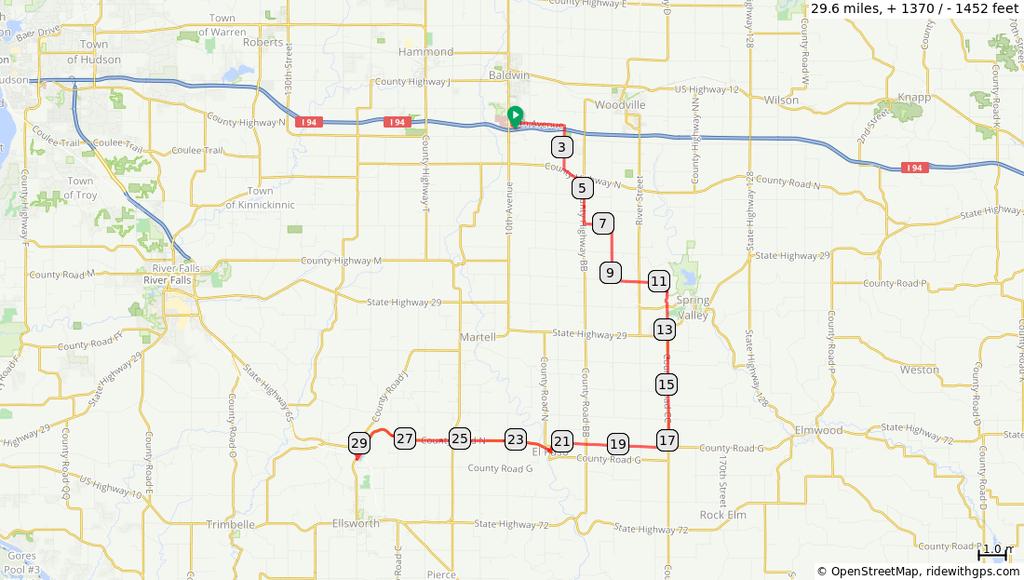
3 d1am Right onto W Snelling Service Rd Left onto Roselawn W Continue straight onto Victoria St N Take path on right to Trout Creek Trail Left on path, caution, steep downhill Stay right. Caution Stay right, Caution Go left. Caution Right onto South McCarrons Boulevard Left on path, Rice Street Right onto Roselawn 4.0 miles. +110/-211 feet Right onto Edgerton St Left onto Gateway State Trail Right onto County Road B East Continue onto 40th Street North Right onto Ideal nue North Left onto Lake Jane Trail North Continue onto 45th Street North Continue onto Julep nue North Continue onto 47th Street North Left onto Kimbro nue North 11.4 miles. +279/-243 feet Continue onto 50th Street North Left onto Stillwater Boulevard North, CR Right onto 53rd Street North Continue onto Neal nue North Left onto 51st Street North Left onto Northbrook Boulevard North Right onto 54th Street North Left onto Obrien N Right onto 55th Street North Left onto Upper 56th Street North Left onto Omaha nue North Right onto 57th Street North Left on Oren Right onto 58th Street North Left onto Oak Park Heights Trail Left on path to parking lot SAG stop. U-turn Left on path towards New Bridge Jog left, on path Left, cross to path. 4.6 miles. +110/-122 feet 1.8 miles. +38/-194 feet Thursday, day 1, Erik's to Somerset. Lunch.
4 Cross at light. Then go Left Cross at light Right on path, New Bridge Left thru paved lot Right on County Road E Left onto Co Hwy V Right onto 150th /White Tail Dr Right onto 155th /White Tail Dr Left onto 47th St/Bright Lake Rd Continue onto 170th Left onto Co Hwy I Left onto Cloutier Dr 11.6 miles. +442/-290 feet Becomes Depot Rd Right onto Main St Everyday Cafe End of route 0.7 miles. +0/-30 feet Thursday, day 1, Erik's to Somerset. Lunch.

5 d1short18 Thursday, day 1. Somerset to hotel. SHORT.
6 d1short Start of route From Everyday, right on Main St Continue. SHORT and LONG split Right onto Parent St Cross Wi-35 and Continue onto Lagrandeur Rd Right onto Rivard St Left onto Aspen Dr Right onto Plum Tree Ln Right onto Birch St Right onto 80th St Left onto Co Hwy C Right onto bridge 2.2 miles. +86/-118 feet Slight right thru parking lot Left onto Raleigh Rd Right onto 192nd Right onto 115th St th St turns left and becomes 185th Right at stop sign. Cross wwi Right onto Nevada Left onto N 3rd St Left onto N Pierce Right onto N 4th St Left onto N Knowles AmeriVu Inn 7.4 miles. +268/-115 feet End of route 0.0 miles. +0/-0 feet Thursday, day 1. Somerset to hotel. SHORT.

7 d1long18 Thursday, day 1. Somerset to hotel. LONG
8 d1long Start of route From Everyday/Kennedy's right on Main St Right onto Spring St. SHORT and LONG split Right onto Sunrise Dr Right onto 170th Continue left onto 50th St/Bright Lake Rd Right onto 165th Right onto 38th St Continue onto County Rd VV Left onto 172nd Right onto 38th St Left onto 180th 6.2 miles. +199/-215 feet Continue right onto 37th St Continue right onto 192nd Left onto Co Hwy I Right onto 205th Right onto 90th St Left onto Co Hwy C Right onto 93rd St Left onto 192nd Right onto 115th St th St turns left and becomes 185th Right at stop sign. Cross Wi Right onto Nevada 14.5 miles. +573/-461 feet Left onto N 3rd St Left onto N Pierce Right onto N 4th St Left onto N Knowles AmeriVu Inn End of route 0.7 miles. +1/-6 feet Thursday, day 1. Somerset to hotel. LONG

9 d2short18 Friday, day 2. Hotel to Lunch to hotel. SHORT.
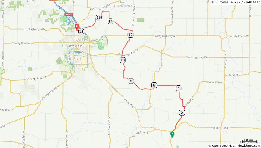
10 d2short Start of route From AmeriVu, left on Wi-65, Knowles Right on 4th Left on Pierce Right on Doughboy Trail Right on Mill Pond Walk Continue on Minnesota Left on 6th Right on Woodland Right on Highview Left on 11th Left onto Co Hwy G Right onto 190th St Left onto 130th 11.3 miles. +399/-262 feet Right onto 220th St Left onto County Rd E Continue onto 100th Slight left onto Rustic Rd Right to Picnic Point Ln U-turn. Shelter. Lunch Left onto Dayuse Dr Left onto Rustic Rd Right onto County Rd E Continue onto 90th Left onto 220th St Right onto 55th 30.6 miles /-1175 feet Left onto Baldwin Plaza Drive DQ Cobblestone End of route 0.9 miles. +0/-29 feet Friday, day 2. Hotel to Lunch to hotel. SHORT.

11 d2-signature Friday, day 2. hotel to Lunch. Signature route.
12 This page intentionally blank.
13 d2-signature Start of route From AmeriVu turn left on Knowles Right onto N 4th St Left onto N Pierce Right onto Doughboy Trail Continue on Mill Pon Walk Continue onto Minnesota Left onto W 6th St Right onto Woodland Ln Right onto Highview Dr Left onto E 11th St 2.5 miles. +58/-28 feet Left onto Co Hwy G/Co Rd G Left onto 190th Street. Signature and SHORT split Right onto 170th nue Right onto 200th Street Right onto 160th nue Make a U-Turn on 160th Right onto 200th Street Right onto County Road G, Make a U-turn on County Rd G Left onto 220th Street 17.4 miles. +382/-293 feet Right onto 170th nue Right onto County Highway O Right onto 160th nue Make a U-Turn on 160th Right onto County Highway O, Left onto County Road G, Left onto 250th Street Right onto 170th nue Right onto 260th Street Sharp right onto 160th nue Make a U-turn on 160th Right onto County Highway D, at Shotgun Suzie's Left onto 150th nue Left onto 290th Street Right onto 170th nue Make a U-turn on 170th Left onto 290th Street Left onto 160th nue Make a U-turn on 160th Left onto 290th St Right onto 300th St 13.0 miles. +279/-238 feet 13.9 miles. +438/-418 feet Friday, day 2. hotel to Lunch. Signature route.
14 Left onto Co Hwy G Right onto 1st St/ Wi Right onto WI-128 S/Syme Join LONG, Left onto Rustic Road Left onto Dayuse Dr Right to Picnic Point Ln U-Turn. Shelter. Lunch End of route 6.5 miles. +261/-270 feet Friday, day 2. hotel to Lunch. Signature route.

15 d2long18 Friday, day 2. Hotel to Lunch to Hotel. LONG.
16 d2long Start of route From AmeriVu, right on Wi-65, Knowles Right onto N Shore Dr Left onto Deere Drive Left onto Johnson Dr Right onto WI-64 E Left onto 145th St Right onto 200th Left onto Co Hwy T Right onto County H Left onto US Hwy 63 N Right onto County Q Right onto County Rd Q 25.9 miles. +812/-614 feet Slight right to stay on County Rd Q Right onto Co Hwy X Slight left to stay on Co Hwy X Left onto 3rd St Right onto E Oak St Left onto WI-128 S/Syme Slight left onto Rustic Rd Left to Glen Hills Park, on Dayuse Dr Right to Picnic Point Ln U-turn. shelter. Lunch Left onto Dayuse Dr Left onto Rustic Rd miles. +776/-667 feet Continue onto 310th St/Wilson St Right onto County Rd N W Right onto 270th St Left onto 50th Left onto Co Hwy B Right onto 50th Right onto 233rd St rd St turns left and becomes 55th Left onto Baldwin Plaza Drive DQ Cobblestone Inn End of route 19.5 miles. +560/-668 feet Friday, day 2. Hotel to Lunch to Hotel. LONG.

17 d3amshort18
18 d3amshort Start of route From Cobblestone, right towards DQ Right onto 55th th turns right and becomes 233rd St Left onto County Rd N E Right onto County Rd BB Go Straight. Short and Long split Right onto 750th Left onto County Rd N Right onto 730th Left onto 450th St th St turns right and becomes 690th Left onto 490th St Right onto County Rd N. Short and Long join Left onto County Rd J Left onto WI-65 S Shady Grove End of route 14.2 miles. +508/-539 feet 9.1 miles. +390/-423 feet
19 d3amlong18
20 d3amlong Start of route From Cobblestone, right towards DQ Right onto 55th th turns right and becomes 233rd St Left onto County Rd N E Right onto County Rd BB Left onto 20th. Short and Long split Right onto 250th Street Left onto 890th nue Right onto Van Buren Road 11.2 miles. +346/-405 feet Cross Wi-29 to follow County CC Right onto 650th At stop sign, continue onto County Rd N Right onto County Rd N Right and follow County Rd N Go straight. Short and Long join Left onto County Rd J Left onto WI Shady Grove End of route 18.4 miles. +819/-796 feet
21 d3pmshort18
22 d3pmshort Start of route From Shady Grove, right on Wi Right onto County Rd J Left onto 690th St Left onto 770th Jog left onto County Rd W, then right on 770th Right onto 850th St/Bearfoot Ln Cross Wi Continue onto Saddle Club Rd Continue onto County Rd JJ Left onto Rifle Range Rd 12.3 miles. +659/-648 feet Right onto Liberty Rd Left onto River Dr Right to stay on River Dr Left onto Quarry Rd Right onto N Main St Left onto Paulson Rd Left onto Riverside Dr Right onto Commerce Ct Country Inn End of route 6.2 miles. +111/-172 feet
23 d3pmlong18
24 d3pmlong Start of route From Shady Grove, left on Wi Continue onto 730th St Right onto County Rd V Left onto 830th St Slight right onto 285th Left onto County Road K Sharp right onto WI Right onto County Road O, Left onto County Road O, Left onto US miles. +746/-907 feet Right onto County Road O, Left onto 710th nue Right onto 910th Street Right on path, WI-35, WI Left onto Cemetery Road, Left onto Jefferson Street Left onto Glen Park Road. Into park Left toward bridge Right onto Swinging Bridge Left onto Winter St Right onto Leroy Ln 12.2 miles. +476/-453 feet Sharp left onto Leroy Lane Left on sidewalk between homes Right on path to join County MM Join County Highway MM. Then left on Oak Ridge Right on Riverside Dr Left into Country Inn Country Inn End of route 0.9 miles. +39/-32 feet
25 CntrInn-BestWstrn
26 CntrInn-BestWstrn Start of route Left onto Oak Ridge Dr Right onto County Hwy MM Left onto N Winter St Left onto Riverwalk Pathway Right, through parking lot to Best Western End of route 2.2 miles. +46/-77 feet

27 d4short18 Sunday, day 4. Hotel to Erik's. SHORT
28 This page intentionally blank.
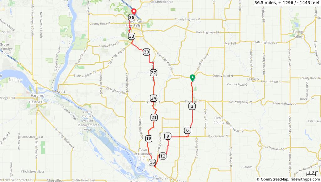
29 d4short Start of route From Country Inn, right on Riverside Left onto Oak Ridge Drive Right onto County Highway MM, Right on Glover Left on Glover Left on Coulee Trail Right onto County Rd F. Join Long route Left onto Mayer Rd Right on River Ridge Left on Croix Crest Go straight on Crest View Left on 11th 10.5 miles. +230/-319 feet Left on Coulee Cross 2nd. left on Sidewalk I-94 bridge Right on Hudson Rd Right onto Stagecoach Trail N Left onto N Hudson Blvd Take bike path SAG stop. Rest Area. Bathrooms Continue onto N Hudson Blvd Continue on bike path Convenience store Cross Manning to Hudson Blvd 8.0 miles. +343/-281 feet Right onto Keats N Left onto 5th St N Right onto Inwood N Left onto 15th Street North Right onto Hinton Trail North Left onto Upper 17th Street North Right onto Helmo nue North Left onto Henslow nue North Left onto 25th Street North Right onto Helena nue North Sharp left onto Stillwater Boulevard North, CR Right on Gresham Left on Granite Left on Upper 28th St Left on Granada Left on Upper 35th St Continue on Holloway Right onto Margaret Street North Left onto Cowern Place East Continue on sidewalk Right on 7th. 7.3 miles. +205/-125 feet 4.1 miles. +117/-155 feet Sunday, day 4. Hotel to Erik's. SHORT
30 Left onto Gateway State Trail Right on Edgerton St Left on Roselawn Cross Rice and right on bike path Left onto North McCarrons Boulevard Left onto McCarrons Boulevard North Right onto Irene Street Left onto Cohansey Street Left onto County B Rd W Left onto Victoria Street North 7.4 miles. +202/-217 feet Right onto Parker nue Right onto Lexington N Left onto Eldridge W Slow. right on sidewalk, thru fence to parking lot Left in lot At stop stigh, left Right to stay near building Right along grocery store Right on entry road Left onto Service Road 1.9 miles. +39/-12 feet Right onto Skillman nue West Erik's End of route 0.1 miles. +0/-0 feet Sunday, day 4. Hotel to Erik's. SHORT

31 d4long18 Sunday, day 4. Hotel to Erik's. LONG.
32 This page intentionally blank.
33 d4long Start of route From Country Inn, right on Riverside Riverside Left on Oak Ridge Right on County MM Left on Winter Right to Path and bridge Swinging Bridge Left on Path Right on Glen Park rd Right on Park st Left on Bartosh Right on Washington/Cemeter y 3.1 miles. +106/-105 feet Right on Greenwood Valley Right on county FF Left on 1090th Right on 748th Left on 748th Right on 754th Right on county QQ Right on county MM Right onto 1250th St Right onto 770th /Kinni-Croix Dr Left onto County Rd F N Left onto Mayer Rd. Short and Long join Right on River Ridge Left on Croix Crest 22.9 miles /-1073 feet Go straight on Crest View Left on 11th Left on Coulee Cross and left on Sidewalk I-94 bridge Right on Hudson Right onto Stagecoach Trail N Left onto N Hudson Blvd Take bike path to left Continue onto N Hudson Blvd Slight left onto bike path Convenience store 8.6 miles. +359/-330 feet Cross Manning to Hudson Blvd Right onto Keats N Left onto 5th St N Right onto Inwood N Left onto 15th Street North Right onto Hinton Trail North Left onto Upper 17th Street North Right onto Helmo nue North Left onto Henslow nue North Left onto 25th Street North 7.1 miles. +270/-141 feet Sunday, day 4. Hotel to Erik's. LONG.
34 Right onto Helena nue North Left onto Stillwater Boulevard North, CR Right on Gresham Left on Granite Left on Upper 28th St Right on Granada Left on Upper 35th St Go straight on Holloway Right onto Margaret Street North Left onto Cowern Place East 3.3 miles. +88/-120 feet Go straight on sidewalk Right on 7th Left onto Gateway State Trail Right on Edgerton St Left on Roselawn Cross Rice, right on bike path Left onto North McCarrons Boulevard Left onto McCarrons Boulevard North Right onto Irene Street Left onto Cohansey Street 7.2 miles. +130/-266 feet Left onto County B Rd W Left onto Victoria Street North Right onto Parker nue Right onto Lexington N Left onto Eldridge W Slow. right on sidewalk thru fence into parking lot Left in lot Left at stop sign Right to stay near building Right along front of Grocery store Right on entry road Use center of 3 lanes at traffic light Left onto Service Road by Erik's Right onto Skillman nue West Erik's End of route 2.8 miles. +82/-18 feet 0.4 miles. +8/-0 feet Sunday, day 4. Hotel to Erik's. LONG.

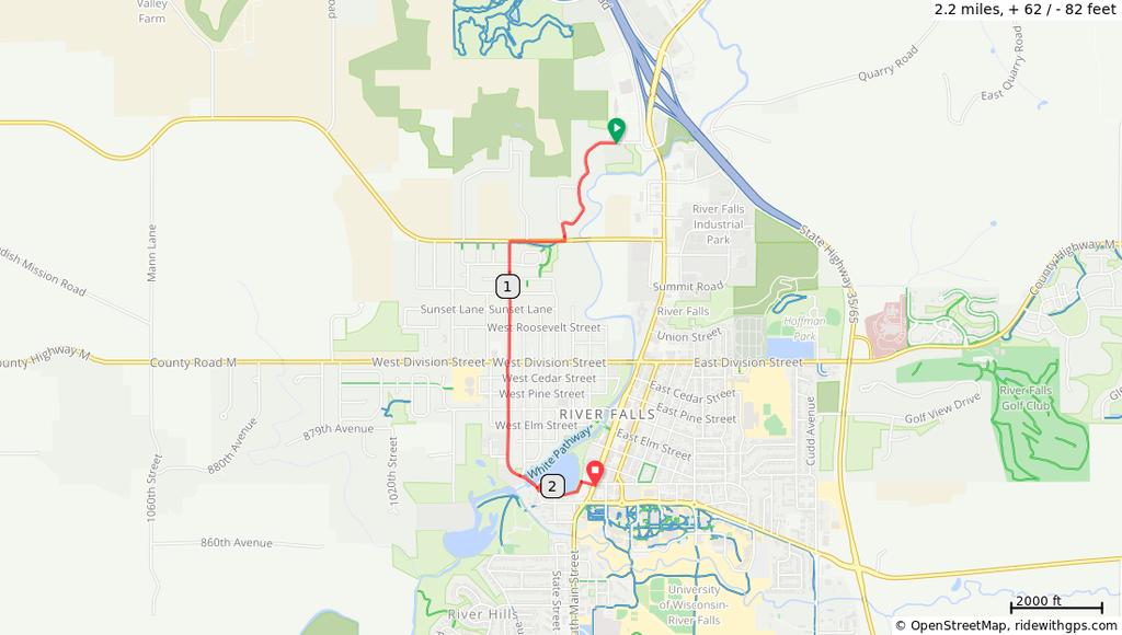
35 car Urban Growler Start of route Right onto W Snelling Dr/Snelling Svc Rd Left at the 1st cross street onto Roselawn W Right at the 1st cross street onto Snelling Como nue exit Right onto Como Left onto Raymond Left onto Hampden W Left onto Bradford St End of route 3.9 miles. +48/-118 feet driving from Erik's to Urban Growler


36 bike UrbanGrowler Start of route Sidewalk to Aldine Left onto Aldine St N Aldine St N turns right and becomes Ryan W Left onto Tatum St Left onto Gortner Left onto Commonwealth Right onto University of Minnesota Transitway Sharp left onto Energy Park Dr Right toward Raymond Right onto Raymond 3.4 miles. +60/-126 feet Left onto Hampden W Left onto Bradford St End of route 0.7 miles. +0/-5 feet bicycling Erik's to Urban Growler.
Eagle Bluff Elementary Pre-K. (This route operates Monday Thru Thursday)
") Ready Bus Company Current as of 3 May 2016 Onalaska School District Route 27M 10:50 AM Depart Bus Garage Eagle Bluff Elementary Pre-K (This route operates Monday Thru Thursday) Left Onto Industrial Blvd
Ready Bus Company Current as of 3 May 2016 Onalaska School District Route 27M 10:50 AM Depart Bus Garage Eagle Bluff Elementary Pre-K (This route operates Monday Thru Thursday) Left Onto Industrial Blvd
EXETER WEST-GREENWICH REGIONAL SCHOOL. Bus:1 1:42 pm Exeter W Greenwich 2:06 pm 542 SPRING STREET
 EXETER WEST-GREENWICH REGIONAL SCHOOL Bus:1 2:06 pm 542 SPRING STREET Bus:2 1:51 pm 124 VICTORY HIGHWAY 1:52 pm 48 VICTORY HWY 1:53 pm 4 VICTORY HIGHWAY 1:53 pm 1 VICTORY HIGHWAY 1:54 pm 21 VICTORY HWY
DIRECTIONS TO GAMES. BIBLE BAPTIST CHRISTIAN SCHOOL 2724 Margaret Wallace Rd Matthews, NC
 BIBLE BAPTIST CHRISTIAN SCHOOL 2724 Margaret Wallace Rd Matthews, NC 704-535-1692 DIRECTIONS TO GAMES Take I-77 S. to Brookshire Freeway towards downtown Charlotte (US-74E). Stay in left lane because exit
San Francisco Randonneurs - King Ridge 400K Start Time XXXX (xx:xx xm) - 27:00 hour time limit
 - 27:00 hour time limit") 0.0 START Start Control: Storey @ Lincoln Blvd Open: +00:00 Close: +01:00 0.0 STRAIGHT (SS) Merchant Rd 0.17 0.2 LEFT Cranston Rd -just before US-101 on ramp 0.04 0.2 RIGHT unnamed road - Cranston Rd -
0.0 START Start Control: Storey @ Lincoln Blvd Open: +00:00 Close: +01:00 0.0 STRAIGHT (SS) Merchant Rd 0.17 0.2 LEFT Cranston Rd -just before US-101 on ramp 0.04 0.2 RIGHT unnamed road - Cranston Rd -
Directions to GMC Middle School Game Sites (updated 8/20/13)
") Bridgetown Bridgetown Middle School, 3900 Race Rd, Cincinnati I-275 West to 74 East to Rybolt Rd, turn left. At Harrison Avenue, turn right and follow to Race Rd. and turn right. School is on the left.
Bridgetown Bridgetown Middle School, 3900 Race Rd, Cincinnati I-275 West to 74 East to Rybolt Rd, turn left. At Harrison Avenue, turn right and follow to Race Rd. and turn right. School is on the left.
Detailed Driving Tour Through Morgan County
 Detailed Driving Tour Through Morgan County MORGAN COUNTY/ FENTRESS COUNTY LINE R.M Brooks General Store (3.8) Gray Gables B&B (3.4) RUGBY (1.3) Details of Community will be added later (Part of the Big
Erie County Van Trip. Pipe Creek Wildlife Area
 Erie County Van Trip ***See red markings on maps indicating the best birding options at each location. Please note that you are not limited to these areas, they are just the areas we feel will be most
Parkland, FL Eruv. Boundaries: North: Loxahatchee Canal till 441and SW 18 th till turnpike South: Sawgrass East: Tunrpike West: Wall at Everglades
 Boundaries: North: Loxahatchee Canal till 441and SW 18 th till turnpike South: Sawgrass East: Tunrpike West: Wall at Everglades DRIVING DIRECTIONS FOR ONE PERSON TO CHECK EVERYTHING Starting Point: Closed
IOWA ORNITHOLOGISTS' UNION - Birding Sites in Polk County
 IOWA ORNITHOLOGISTS' UNION - Birding Sites in Polk County Printed on 2/26/2019 Ashworth Park (ebird Hotspot) (Important Bird Area) GPS Coordinates: 41.5754971,-93.6830641 Ownership: City Big Creek SP (ebird
Bisbee-Tombstone Day 1 Thursday, November 7 th 7 AM Departure from Sand Canyon
 Bisbee-Tombstone Day 1 Thursday, November 7 th 7 AM Departure from Sand Canyon Split Gas Stop Group 1 76 on Left Group 2 Chevron on Right Stage at 76 Comfort Inn Casa Grande 2145 E. Florence Blvd Casa
GILBERT REAL ESTATE & PROPERTY MANAGEMENT 2407 Chambliss Avenue NW, Cleveland, TN / Phone GV0020PP\
 GILBERT REAL ESTATE & PROPERTY MANAGEMENT 2407 Chambliss Avenue NW, Cleveland, TN 37311 / Phone 423 479-7727 Monday Friday 8:30 AM GV0020PP\ - 5:00 PM / Saturday 9 AM 12 NOON Please view our list on the
ADVANCE INFORMATION PACKET
 ADVANCE INFORMATION PACKET FOR THE RALLY COLORADO, PROSPECTORS RUN RALLY AND BLAZIN SADDLES RALLY The Town of Rangely July 20-21, 2018 Colorado Rio Blanco County Organized by: Rally America Inc. / Rally
Rita's Ride This is a Lung Cancer benefit ride. It is in 4 legs with a stop ending each leg. Directions from Rex's Innkeeper to Nora's Two
 Rita's Ride 2018 Directions from Rex's Innkeeper to Nora's Two Rex's Innkeeper, North Century Avenue, Waunakee, WI, USA Nora's Two, U.S. 12, Deerfield, WI, USA Directions from Nora's Two to Paoli Bar and
Western CT and Dutchess Ride 219 miles
 Western CT and Dutchess Ride 219 miles Western CT and Dutchess Ride 219 miles 0.0 mi - Quality Inn & Suites-Fishkill 0.0 mi - Turn left out of driveway on Route 52 east 0.2 mi - Take the I-84 E ramp to
DIRECTIONS TO TESTING SITES:
 DIRECTIONS TO TESTING SITES: CONWAY MEDICAL CENTER 300 SINGLETON RIDGE ROAD, CONWAY, SC 843-347-7111 FROM HWY 17S, 17N or 31S from N. MYRTLE BEACH/MYRTLE BEACH/SURFSIDE/ CHARLESTON: Exit Hwy 17 Bypass
GILBERT REAL ESTATE & PROPERTY MANAGEMENT 2407 Chambliss Avenue NW, Cleveland, TN / Phone PP\
 APARTMENTS BR BATH RENT DEPOSIT DESCRIPTION 3236 Weeks Horizon Dr NE 3 3 1250 1000 Townhouse, all app, ch/a, wd hook-up *no smoking 3212 Weeks Horizon Dr NE 2 2 1050 1000 All app, ch/a, wd hook-up, one
the victory companies
 the victory companies January 23-24 & 30-31 12 pm to 4 pm www.victorycompaniesofwisconsin.com VICTORY homes of wisconsin, inc. Distinctive designs. Superior craftsmanship. Welcome to our January Tour of
GILBERT REAL ESTATE & PROPERTY MANAGEMENT 2407 Chambliss Avenue NW, Cleveland, TN / Phone PP\
 GILBERT REAL ESTATE & PROPERTY MANAGEMENT 2407 Chambliss Avenue NW, Cleveland, TN 37311 / Phone 423 479-7727 Monday Friday 8:30 AM PP\ - 5:00 PM / Saturday 9 AM 12 NOON Please view our list on the internet
PORT SUSAN MIDDLE SCHOOL SPORTS SEASONS DIRECTIONS
 2014-2015 PORT SUSAN MIDDLE SCHOOL SPORTS SEASONS DIRECTIONS ANACORTES SCHOOLS Anacortes High School 1916 J. Ave. Anacortes, WA 98221 Take Hwy 20 to Anacortes. Take a right on Commercial. Take a left on
Cathedral of the Sacred Heart 18 N. Laurel Street Richmond, VA 23220
 Cathedral of the Sacred Heart 18 N. Laurel Street Richmond, VA 23220 From the North, take 95 South to Exit 76 Belvidere Street US 1/Route 301), make left onto W. Leigh, take the 2nd right onto N/S Belvidere
GILBERT REAL ESTATE & PROPERTY MANAGEMENT 2407 Chambliss Avenue NW, Cleveland, TN / Phone PP\
 GILBERT REAL ESTATE & PROPERTY MANAGEMENT 2407 Chambliss Avenue NW, Cleveland, TN 37311 / Phone 423 479-7727 Monday Friday 8:30 AM PP\ - 5:00 PM / Saturday 9 AM 12 NOON Please view our list on the internet
HOLIDAY HOP TO SOLVANG Saturday, Feb 17, 2001 Carpinteria to Solvang 63 Miles
 Saturday, Feb 17, 2001 Carpinteria to Solvang 63 Miles From Park and Ride Lot on Linden Av at 7 th St in Carpinteria, Northeast on LINDEN AV. 0.0 0.2 L----- 7 TH ST 0.2 0.5 R ---- SANTA YNEZ AV 0.7 0.2
Willamette Valley Pie Co nd Ave NE, Salem, OR 97305
 The Full Loop Marion Farm Loop Drive 120 miles, 3 h 23 min The Full Marion Farm Loop is a 120 mile,full day journey around all 23 farm stops. You'll find everything from family farms, to wineries, to nurseries,
Emergency Phone Number
 1 BIKE MS 15 Miles Miles Action Road Name Route or Number 0.0 Start North Trail 0.2 Right Tanglewood Park 1.7 Left Tanglewood Park 2.2 Left Idols 3.7 Right Hampton 4.3 Left Frye Bridge 4.5 Straight Frye
Chesapeake Science Point Bus Routes
 Chesapeake Science Point Bus Routes Route #1: Lake Waterford Park to CSP a. Lake Waterford Park 1) Head west on Pasadena Rd towards Jake s Ln 2) Continue onto East-West Blvd 3) At the traffic circle, take
GILBERT REAL ESTATE & PROPERTY MANAGEMENT 2407 Chambliss Avenue NW, Cleveland, TN / Phone PP\
 GILBERT REAL ESTATE & PROPERTY MANAGEMENT 2407 Chambliss Avenue NW, Cleveland, TN 37311 / Phone 423 479-7727 Monday Friday 8:30 AM PP\ - 5:00 PM / Saturday 9 AM 12 NOON Please view our list on the internet
Bullhead City, AZ. Topock, Oatman, Mr Dz, Grand Canyon Skywalk, Dolan, 276 miles. Take Laughlin Ranch Blvd to Bullhead Pkwy. 3 min (1.
 Bullhead City, AZ to Bullhead City Community Park Topock, Oatman, Mr Dz, Grand Canyon Skywalk, Dolan, 276 miles Drive 276 miles, 6 h 4 min Map data 2015 Google 10 mi Bullhead City, AZ Take Laughlin Ranch
GILBERT REAL ESTATE & PROPERTY MANAGEMENT 2407 Chambliss Avenue NW, Cleveland, TN / Phone PP\
 GILBERT REAL ESTATE & PROPERTY MANAGEMENT 2407 Chambliss Avenue NW, Cleveland, TN 37311 / Phone 423 479-7727 Monday Friday 8:30 AM PP\ - 5:00 PM / Saturday 9 AM 12 NOON Please view our list on the internet
Training Property Guidelines
 Training Property Guidelines The following Guidelines list important considerations for the use of the pre-national Training Grounds and Invitational Test Grounds that are, thanks to the generosity of
Route:J SKVMam SKYVIEW MS J
 Route:J SKVMam SKYVIEW MS J 7:10 am STILLWATER RD E@FERNDALE ST N 7:11 am STILLWATER RD E @ STERLING ST N 7:11 am STILLWATER RD E @ BARTELMY LN N 7:12 am 1000 LAKEWOOD DR N 7:13 am 1068 LAKEWOOD DR N 7:13
Directions for Soccer
 Directions for Soccer Morris Plains- School field Directions to 500 speedwell Ave, Morris plains, NJ 2 Take the ramp onto I-80 E - go 11.7 mi 3 Take exit 42A-42C for US-202 toward Morris Plains/Parsippany
GILBERT REAL ESTATE & PROPERTY MANAGEMENT 2407 Chambliss Avenue NW, Cleveland, TN / Phone PP\
 GILBERT REAL ESTATE & PROPERTY MANAGEMENT 2407 Chambliss Avenue NW, Cleveland, TN 37311 / Phone 423 479-7727 Monday Friday 8:30 AM PP\ - 5:00 PM / Saturday 9 AM 12 NOON Please view our list on the internet
Field Directions: Alabaster Soccer
 Field Directions: Alabaster Soccer Municipal Park From I65 take Exit 238 Alabaster/Saginaw to 31N to Hwy 119 (first light you come to). Take a left onto 119. Go to the third light and turn right onto Thompson
Route:P TARTam TARTAN P Notes:
 Route:P TARTam TARTAN P 7:38 am LAKEWOOD DR N@TILSEN CT E 7:40 am MCKNIGHT RD N @ TILSEN AVE 7:44 am ARLINGTON AVE E @ MYRTLE ST N 7:46 am NEBRASKA AVE E @ CURRIE ST N 7:47 am CURRIE ST N @ MONTANA AVE
OK Freewheel. Trail. Chisholm. All Route Maps and Cue Sheets (Day 0-7) June 11-17, Ponca City. Enid. Kingfisher. Chickasha. Duncan.
 June 11-17, Ponca City. Enid. Kingfisher. Chickasha. Duncan.") June 11-17, 2017 OK Freewheel Chisholm Trail South Haven, KS Enid Chickasha Comanche Ponca City Kingfisher Duncan Wichita Falls, TX Celebrating the 150th Anniversary of the Historic Chisholm Trail All
June 11-17, 2017 OK Freewheel Chisholm Trail South Haven, KS Enid Chickasha Comanche Ponca City Kingfisher Duncan Wichita Falls, TX Celebrating the 150th Anniversary of the Historic Chisholm Trail All
Texas Water Safari Driving Directions
 Texas Water Safari Driving Directions v4 Revised March 2014 While I try to make sure these directions are accurate and up to date...i make no promises. I try to update this each year so please send any
CHIPPEWA FALLS. Chippewa Falls High School 735 Terrill Street Chippewa Falls WI 54729
 CHIPPEWA FALLS Four of the schools in Chippewa Falls are located within a 4-block radius, please use the basic instructions for the Chippewa Falls High School to get to these four schools: Chippewa Falls
FOR SALE 8.24 ACRES. Development Site with Exceptional Freeway Visibility HADEN ONGARO RON REINKING COMMERCE BOULEVARD ROHNERT PARK // CA
 Development Site with Exceptional Freeway Visibility Wilfred Avenue 5300 COMMERCE BOULEVARD ROHNERT PARK // CA Golf Course Drive FOR SALE $8,300,000 $23/SF Commerce Boulevard Cascade Court COMMERCIAL/INDUSTRIAL
GILBERT REAL ESTATE & PROPERTY MANAGEMENT 2407 Chambliss Avenue NW, Cleveland, TN / Phone PP\
 APARTMENTS BR BATH RENT DEPOSIT DESCRIPTION 3221 Weeks Horizon Dr NE *3236 3 3 1250 1000 Townhouse, all app, ch/a, wd hook-up *no smoking 3212 Weeks Horizon Dr NE *3218 2 2 1050 1000 All app, ch/a, wd
INDEX WIAA ATHLETIC CARDS
 WIAA ATHLETIC CARDS Green athletic cards are required whenever a student participates in a WIAA athletic sport. They must be signed by the physician. Green cards are good for two years, with the alternate
GILBERT REAL ESTATE & PROPERTY MANAGEMENT 2407 Chambliss Avenue NW, Cleveland, TN / Phone PP\
 GILBERT REAL ESTATE & PROPERTY MANAGEMENT 2407 Chambliss Avenue NW, Cleveland, TN 37311 / Phone 423 479-7727 Monday Friday 8:30 AM PP\ - 5:00 PM / Saturday 9 AM 12 NOON Please view our list on the internet
BAY MEADOWS SPECIFIC PLAN
 BAY MEADOWS SPECIFIC PLAN Adopted by the San Mateo City Council April 22, 1997 Amended March 4, 2002, November 4, 2005 and January 4, 2010 BAY MEADOWS SPECIFIC PLAN Adopted by the San Mateo City Council
GILBERT REAL ESTATE & PROPERTY MANAGEMENT 2407 Chambliss Avenue NW, Cleveland, TN / Phone GV0020PP\
 GILBERT REAL ESTATE & PROPERTY MANAGEMENT 2407 Chambliss Avenue NW, Cleveland, TN 37311 / Phone 423 479-7727 Monday Friday 8:30 AM GV0020PP\ - 5:00 PM / Saturday 9 AM 12 NOON Please view our list on the
Directions to Office
 Directions to Office Sara Westgate, M.D., Ph.D. What area are you coming from? 1. North Austin, north of HWY 71 Ben White / HWY 290 proceeding south on MOPAC 2. Arboretum proceeding south on Loop 360,
Directions to Shore Conference Fields
 Directions to Shore Conference Fields MONMOUTH COUNTY ASBURY PARK Field address: Sunset Avenue, Asbury Park Directions: From South -- Parkway Exit 100A. Take Route 66 east to traffic circle. Follow Route
Route:P TARTam TARTAN P
 Route:P TARTam TARTAN P 7:38 am LAKEWOOD DR N@TILSEN CT E 7:40 am MCKNIGHT RD N @ TILSEN AVE 7:44 am ARLINGTON AVE E @ MYRTLE ST N 7:46 am NEBRASKA AVE E @ CURRIE ST N 7:47 am CURRIE ST N @ MONTANA AVE
Route:D TARTam TARTAN D
 Route:D TARTam TARTAN D 7:35 am MAILAND RD E@CRESTVIEW DR S 7:36 am LAKEWOOD DR S @ TEAKWOOD DR E 7:37 am MARNIE ST S @ HILLWOOD DR E 7:38 am HILLWOOD DR E @ DORLAND RD S 7:39 am DORLAND RD S @ LINWOOD
Updated: April 7, 2016
 Updated: April 7, 2016 Hwy 36 to Lexington Ave. Add a lane in each direction Recommend a MNPASS Lane Several spot improvements to roadway included Concrete pavement Noise walls will be evaluated Replace
VERMONT LACROSSE FIELD DIRECTIONS
 VERMONT LACROSSE FIELD DIRECTIONS OVERVIEW- Below are directions to area lacrosse fields with details on where the lacrosse fields are located. They are arranged by team (alphabetically). Below each team
2016 FIELD DIRECTORY
 2016 FIELD DIRECTORY WILSON AVONA FIELDS - From Route 611 North- Follow route 611 North, turn left onto Browns Drive. Turn right onto Old Well Road. Turn left onto Morgan Hill Road. Turn right onto Diehl
GILBERT REAL ESTATE & PROPERTY MANAGEMENT
 GILBERT REAL ESTATE & PROPERTY MANAGEMENT 2407 Chambliss Avenue NW, Cleveland, TN 37311 / Phone 423 479-7727 Monday Friday 8:30 AM - 5:00 PM / Saturday 9 AM 12 NOON Please view our list on the internet
Start at Budget Inn, 1001 Olive St, San Luis Obispo, CA Control open 05:00-06:00. Exit right on Olive St.
 California Coasting 400k. Emergency call Terry Hutt 909.362.0956 Dist Type Next Note 0.0 0.1 Start at Budget Inn, 1001 Olive St, San Luis Obispo, CA 93405. Control open 05:00-06:00. Exit right on Olive
BUS ROUTES FOR BOLTON SCHOOLS Bolton schools will open Wednesday, August 28th. The K-5 school day will begin at 8:30 AM.
 2013-2014 BUS ROUTES FOR BOLTON SCHOOLS Bolton schools will open Wednesday, August 28th. The K-5 school day will begin at 8:30 AM. and end at 3:25 PM. The 6 th, 7 th & 8 th grade school day will begin
Arkansas State Highway and Transportation Department
 Arkansas State Highway and Transportation Department Fayetteville Rotary Club Mermaids Restaurant Thursday, January 30, 2014 About AHTD The Facts: 12 th Largest System in USA 43 rd Highway Revenue Per
GILBERT REAL ESTATE & PROPERTY MANAGEMENT 2407 Chambliss Avenue NW, Cleveland, TN / Phone
 APARTMENTS BR BATH RENT DEPOSIT DESCRIPTION 3208 Weeks Horizon Dr NE *3234 2 2.5 1100 1000 Townhouse, all app, ch/a, wd hook-up *no smoking 1701 Woodmore Dr NW 2 1 850 300 All app, ch/a, carport *1703
Calendar of Events Bird Walks, Hikes, Programs, & Special Events January March 2019
 Valley Forge Audubon Society & John James Audubon Center at Mill Grove Calendar of Events Bird Walks, Hikes, Programs, & Special Events January March 2019 1201 Pawlings Road, Audubon, PA 19403 Phone: 610-666-5593
STEVENS - POND HILL Route #: 39 8:28 AM 821 CLINTONVILLE RD 821 CLINTONVILLE RD 11 HUNTINGTON RIDGE RD 21 HUNTINGTON RIDGE RD CLINTONVILLE MOLLY
 STEVENS - POND HILL Route #: 39 8:28 AM 821 CLINTONVILLE RD 821 CLINTONVILLE RD 11 HUNTINGTON RIDGE RD 21 HUNTINGTON RIDGE RD CLINTONVILLE RD@ MOLLY ONEILL RD 920/921 CLINTONVILLE RD 925 CLINTONVILLE RD
One Good Turn. Coulee Region Woodturners. Chapter of the American Association of WoodTurners.
 One Good Turn Coulee Region Woodturners Chapter of the American Association of WoodTurners Www.crwoodturner.com Last month, Duane Hill showed how to make a three-point tool from a high-speed steel tool
MERAMEC VALLEY R-III SCHOOL DISTRICT ESY 2014 Bus # 8 AM -- Coleman Elementary
 Bus # 8 Tom 7:25 AM 999 St Mary's Rd 4:13 PM RIGHT Coventry Farms 7:30 AM Coventry Farms @ Y 4:11 PM TURN AROUND RIGHT St. Mary's 7:35 AM St Mary's Rd & Fantasy Lane 4:09 PM LEFT Hwy AT RIGHT Hwy M 7:40
GILBERT REAL ESTATE & PROPERTY MANAGEMENT 2407 Chambliss Avenue NW, Cleveland, TN / Phone PP\
 APARTMENTS BR BATH RENT DEPOSIT DESCRIPTION 3236 Weeks Horizon Dr NE 3 3 1250 1000 Townhouse, all app, ch/a, wd hook-up *no smoking 3212 / 3218 Weeks Horizon Dr NE 2 2 1050 1000 All app, ch/a, wd hook-up,
GILBERT REAL ESTATE & PROPERTY MANAGEMENT 2407 Chambliss Avenue NW, Cleveland, TN / Phone PP\
 GILBERT REAL ESTATE & PROPERTY MANAGEMENT 2407 Chambliss Avenue NW, Cleveland, TN 37311 / Phone 423 479-7727 Monday Friday 8:30 AM PP\ - 5:00 PM / Saturday 9 AM 12 NOON Please view our list on the internet
Countryside Montesorri aerial
 FOR SALE +/- 27,697 SF SECIAL UROSE FACILITY University Research ark Area - Charlotte, NC 9106-9108 Mallard Creek Road, Charlotte, NC 28262 Countryside Montesorri aerial ROERTY DETAILS FOR SALE: $3,250,000
FARM TO MARKET 1103 OPEN HOUSE PUBLIC MEETING. FM 1103 I-35 to Rodeo Dr
 FARM TO MARKET 1103 OPEN HOUSE PUBLIC MEETING March 29, 2016 FM 1103 FROM: I-35 TO: RODEO DR COMAL & GUADALUPE COUNTY OPEN HOUSE PUBLIC MEETING March 29, 2016 5:00 p.m. 7:00 p.m. Barbara C Jordan Intermediate
Bus Driver Directions For CA01ASS CASTLIO SUM 17 KINDER IN. Start Time: End Time: Total Time: Distance: 08:15 am 09:00 am 44: mi.
 5/8/07 7:53:39 AM First Planning Solutions Page Bus Driver Directions For CA0ASS CASTLIO SUM 7 KINDER IN Route: CA0ASS Bus: Driver: Anchor: CASTLIO ES Start Time: End Time: Total Time: Distance: 08:5 am
Little League District 19 New York District Administrator George Serrano. Directions to Little League Fields
 Chester: From 17 east it is exit 126 (New exit). Make a left and then just go straight on to Rte. 94 and then Take this to a T and turn left onto Rte. 94. Follow road and bear right in front of the firehouse.
WELCOME. Open House. meeting is downstairs in the Foot Room RED WING BRIDGE PROJECT. US 63 River Bridge and Approach Roadways.
 WELCOME RED WING BRIDGE PROJECT US 63 River Bridge and Approach Roadways Open House meeting is downstairs in the Foot Room November 2016 Plum/3rd Street Traffic Control Change Signal to All-Way Stop Plum
V3 Hopfest 100 Mile Ride 2018 Distance: mi Elevation Gain: 4,573 ft Elevation Max: 1,622 ft. Notes
 V3 Hopfest 100 Mile Ride 2018 Distance: 97.63 Elevation Gain: 4,573 ft Elevation Max: 1,622 ft Notes 0.00 Head northwest toward Executive Pkwy 0.03 Turn right onto Executive Pkwy 0.11 Turn left onto Cano
GILBERT REAL ESTATE & PROPERTY MANAGEMENT 2407 Chambliss Avenue NW, Cleveland, TN / Phone
 GILBERT REAL ESTATE & PROPERTY MANAGEMENT 2407 Chambliss Avenue NW, Cleveland, TN 37311 / Phone 423 479-7727 Monday Friday 8:30 AM - 5:00 \ PM / Saturday 9 AM 12 NOON Please view our list on the internet
This page is intentionally left blank
 This page is intentionally left blank This page is intentionally left blank MnDOT Metro District Fact Sheet Mpls./St. Paul District Offices: Roseville-Water's Edge (HQ), Golden Valley, Oakdale mndot.gov/metro/
Houston Service Unit Depots
 Houston Service Unit s 1. Angleton (B321) 2. Basin (HB001) 3. Bloomington (B219) 4. Booth Yard (HB002) 5. Coady Yard (BG027) 6. Corpus Christi (CC150) 7. Dayton (LS407 8. Eagle Lake (SO069) 9. Eldon (LF216)
IOWA ORNITHOLOGISTS' UNION - Birding Sites in Story County
 IOWA ORNITHOLOGISTS' UNION - Birding Sites in Story County Printed on 3/15/2019 Ada Hayden Park (ebird Hotspot) (Important Bird Area) GPS Coordinates: 42.0728262,-93.6245656 (Formerly Hallett s Quarry)
Pend Oreille County Current Road Restrictions
 5th St Stage 3 0.472 0.926 Usk Bridge to Leclerc Rd North/Leclerc Rd South/Kings Lake Rd Acre Dr Stage 3 0.000 0.480 Loren St to Alberta Rd Alberta Rd Stage 3 0.010 0.230 Amy St to Joyner Dr East Allen
Greene County Resources
 Greene County Resources Health and Community Resources University of Missouri Extension- Greene County 2160 W. Chesterfield Blvd. Suite F200 Phone: 417-886-2059 Email: greeneco@missouri.edu http://extension.missouri.edu/greene
Maine Drone Peace Walk Schedule
 Maine Drone Peace Walk Schedule October 10-19, 2013 Welcome & Register We invite you to consider joining the October 10-19 Preserve our Privacy: No Drone Spying in Maine peace walk. The walk is being organized
WOODLAND HIGH SCHOOL WOODLAND REGIONAL HIGH SCHOOL
 WOODLAND HIGH SCHOOL 2016-2017 BEACON FALLS BUS ROUTES BUS NUMBER 20 20 Woodland AM 6:50 am 2 NORTH MAIN ST SOUTH CIRCLE @ ISLAND CHURCH & BEACON ST 6:55 am 69 N MAIN ST RAILROAD AVE & DEPOT ST RAILROAD
Greensboro Salem Fork
 Greensboro Sparta Warrensville GSO Ocean Isle GSO 0km start: 09/03 04:00 C-T = Control Total Greensboro Salem Fork 0.0 0.0 Right 1.5 National Srv Rd 1.5 1.5 Right.6 Tyner Rd 2.1 2.1 Right 1.1 Sandy Ridge
Fiesta Wildflower Ride 60 Mi
 New Braunfels 10 10 Gin Rd (CR 304) Solms Rd Ron Rd Marion Rd Marion 78 New Berlin CR 415 Green Valley Rd Weil Rd Gin Rd (CR 304) Krueger Canyon Rd Schoenthal Rd 482 Schertz Cibolo Caution! Steep Downhill
PINELLAS COUNTY MPO FY 2013/ /18 TRANSPORTATION ALTERNATIVES (TA) PROGRAM PRIORITY LIST STATUS REPORT
 PROGRAM PRIORITY LIST STATUS REPORT") PINELLAS COUNTY FY 2013/14-2017/18 A City of Sexton Elementary School sidewalk along 19 th St. N. from 38 th Ave. N. to 52 nd Ave. N. N/A N/A Safe Routes to School received (see footnote 7) B Pinellas
PINELLAS COUNTY FY 2013/14-2017/18 A City of Sexton Elementary School sidewalk along 19 th St. N. from 38 th Ave. N. to 52 nd Ave. N. N/A N/A Safe Routes to School received (see footnote 7) B Pinellas
Directions to Away Schools
 Directions to Away Schools BEAR CREEK PARK- Take I-25 to US 24 west (exit 141). Continue traveling west on US 24. Turn left on 21 st Street. Drive south for approximately 1.5 miles. Turn left on Rio Grande
Glocester Elementary School Bus Routes Updated August 20, West Glocester Elementary School & Fogarty Memorial School
 Glocester Elementary School Bus Routes 2013-14 Updated August 20, 2013 West Glocester Elementary School & Fogarty Memorial School Please e-mail the bus coordinator globusco@fg.k12.ri.us with any questions
AEC Board of Directors
 AEC Board of Directors Gary Jett District 1 Mark Isom District 2 Vice-President Gail Hickman Vacant Eric Fritz District 3 Dale Fain President District 6 District 8 Sue McBee District 4 John Austin Secretary-Treasurer
MVLL 2018 FALL BALL WEEK SIX SCHEDULE BASEBALL
 DIVISION TEAM OPPONENT DATE TIME LOCATION 9/10 MV GREEN PORT JERVIS 10/13/2018 1:00 PM PORT JERVIS BASEBALL FIELD 9/10 MV WHITE CORNWALL GREEN 10/13/2018 3:30 PM CORNWALL MINOR FIELD 9/10 MV BLACK NEW
GILBERT REAL ESTATE & PROPERTY MANAGEMENT 2407 Chambliss Avenue NW, Cleveland, TN / Phone
 GILBERT REAL ESTATE & PROPERTY MANAGEMENT 2407 Chambliss Avenue NW, Cleveland, TN 37311 / Phone 423 479-7727 Monday Friday 8:30 AM - 5:00 \ PM / Saturday 9 AM 12 NOON Please view our list on the internet
GILBERT REAL ESTATE & PROPERTY MANAGEMENT 2407 Chambliss Avenue NW, Cleveland, TN / Phone
 GILBERT REAL ESTATE & PROPERTY MANAGEMENT 2407 Chambliss Avenue NW, Cleveland, TN 37311 / Phone 423 479-7727 Monday Friday 8:30 AM - 5:00 \ PM / Saturday 9 AM 12 NOON Please view our list on the internet
Jefferson R-VII Bus Routes 2017 (approximate times)
") Bus #1 Jefferson R-VII Bus Routes 2017 (approximate times) Hwy 61 Manderly Court Airport Road/ Calvary Church Rd. VFW/Buck Knob (River Hills) American Legion/England Drive - Hwy 67 (Hundred Oaks) Hwy CC
Bus #1 Jefferson R-VII Bus Routes 2017 (approximate times) Hwy 61 Manderly Court Airport Road/ Calvary Church Rd. VFW/Buck Knob (River Hills) American Legion/England Drive - Hwy 67 (Hundred Oaks) Hwy CC
Route:C NORTam NORTH C
 Route:C NORTam NORTH C 7:49 am FROST AVE E@IDE ST N 7:50 am FROST AVE E @ MANTON ST N 7:51 am FROST AVE E @ HAZELWOOD ST N 7:52 am PROSPERITY RD @ HARRIS AVE E 7:53 am PROSPERITY RD @ BURKE AVE E 7:54
BRIDGEPORT COMMUNITY HEALTH CENTER 471 Barnum Avenue Bridgeport, CT /
 The following is a list of Community Health Centers in Connecticut. They provide comprehensive, family-oriented, culturally competent medical, dental and social services to the uninsured and underinsured.
Hwy 36 to Lexington Ave. Add a lane in each direction Recommend a MNPASS Lane Several spot improvements to roadway included Concrete pavement Noise
 Hwy 36 to Lexington Ave. Add a lane in each direction Recommend a MNPASS Lane Several spot improvements to roadway included Concrete pavement Noise walls will be evaluated 2 Approximate $200 million construction
Pend Oreille County Current Road Restrictions
 5th St Stage 3 0.472 0.926 Usk Bridge to Leclerc Rd North/Leclerc Rd South/Kings Lake Rd Acre Dr Stage 3 0.000 0.480 Loren St to Alberta Rd Alberta Rd Stage 3 0.010 0.230 Amy St to Joyner Dr East Allen
Woodland School District - Proposed Board Districts as Approximated Using Census 2010 Geography Blue Lk. Lewis Riv. Lewis Riv.
 Woodland School - Blue Lk 1st 2nd Mc Bride Lk 3rd 4th Merrill Lk 5th Lew Yale Lk Riv Riv Lk Riv Lk YaleRiv Riv Riv Lk Merwin Lk Merwin Siouxon Crk Riv Riv e Lk Slough e Martin Lk Riv Burke Slough Riv Lk
Locate Request Information
 Locate Request Information NOTE: DO NOT USE any apostrophes ( )or quotation marks ( ) in Web Ticket Entry. Doing so may hamper the transmission of tickets to the utilities and locators. Limit per Ticket
Chapter 4a GUIDE SIGNS
 Sign Designs and Markings Manual (TEM 295-2) Chapter 4a GUIDE SIGNS DIRECTIONAL ( D sign code numbers) Revised January 20, 2012 Guide Signs Directional Page 4a-2 Sign Designs and Markings Manual (TEM 295-2)
JERSEY SHORE BEACH BLAST
 JERSEY SHORE BEACH BLAST DIRECTIONS TO TOURNAMENT FIELDS RED BANK REGIONAL HS- (101 Ridge Rd, Little Silver NJ 07739) From the south: Take the Garden State Parkway to Exit 109 Exit parkway and proceed
Robert B. Sussan, Chief Road Captain American Legion Legacy Run. 05/22/ Legacy Run Hotels and Campsites Page 1 of 14
 May nd, 08 Dear Legacy Run Registrants, Attached are the Hotel and Campsite lists for the th Annual Legacy Run from Post 8 in Hutchinson, KS to Post 0 in Anoka, MN. This year s run will be five days and
Pay Stations and Drop Boxes
 s and es Companies are listed in alphabetical order by state. Idaho 4 th Street 1217 N. 4 th St. Coeur d Alene, ID 83814 Archie's IGA 105 E. College Ave. Saint Maries, ID 83861 Hours: Monday Friday 7:00
Stafford, CT Voting Districts
 Stafford, CT Voting Districts Sodom Rd Gulf Rd Rocky Dundee Rd Old Country RdGilbert Rd Handel Rd Boyer Rd Spencer Rd W Galbraith Rd Spusta Rd Old Springfield Rd Rte 190 Old Birch Rd Spencer Rd State Hwy
DOWNTOWN STYLE. SUBURBAN EASE.
 DOWNTOWN STYLE. SUBURBAN EASE. Page // 1 Enjoy the best access to metro available in the Rockville CBD as well as: Adjacent to MARC train and Rockville Metro Station on the Red Line Landmark Clock Tower
Solomons VRSFD 2015 SANTA RUNS
 Solomons VRSFD 2015 SANTA RUNS Friday December 18, 2015 Load up at CRE Front Gate Clubhouse to Rio Grande Trail Right onto Cayuse Circle Right onto Rio Grande Trail Left onto East Range Rd Left onto Long
NEW CONSTRUCTION - DUPAGE COUNTY BLOOMINGDALE CORPORATE CENTER BLOOMINGDALE, ILLINOIS
 FINISH TO SUIT - DELIVERY 4Q2016 255 MADSEN 260 MADSEN 270 MADSEN BUILDING SIZE: 51,600 SF 25,800 SF - 51,600 SF 4.48 Acres Dock Positions: 6 (Expandable) Drive-in-Doors: 1 (Expandable) 63 Cars (Expandable)