UK experience of converting mapping data from national grid to EU grid
|
|
|
- Constance Boyd
- 5 years ago
- Views:
Transcription

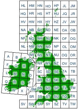
1 UK experience of converting mapping data from national grid to EU grid Stephen Grady and Graham French, JNCC
2 Mapping baseline grids used in the UK There are three mapping grids used across the UK 1) British National Grid OSGB36 (used for England, Scotland and Wales habitats & species) 2) Irish National Grid (TM65)* (used for Northern Ireland habitats & species) 3) World Geodetic System WGS84 (used for UK Offshore marine and Gibraltar habs & species) *The Irish grid partially overlaps the British grid. It uses uses a similar coordinate system but with a central meridian more suited to its westerly location. UK in Atlantic (terrestrial) biogeographical region and Atlantic marine region. (Gibraltar in Mediterranean (terrestrial) biogeographical region and Mediterranean marine region.
3 EU mapping projection standard EU reporting guidelines require each MS to convert mapping data from their national grid(s) into: 10 km x 10 km ETRS89 grid, projection ETRS LAEA 5210* *European Terrestrial Reference System 1989; Lambert Azimuthal Equal Area Latitude of origin 52 o N, Longitude of origin (central meridian) 10 o E.
4
5 UK approach to conversion 1) Overlay grids in GIS, via comparator algorithm 2) Match each of the individual GB/Ireland grid squares with the 10 km ETRS square that has the maximum overlap with the GB/Ireland square In this example: Green source distribution square in BNG Red ETRS grid square A Blue ETRS grid square B Green square has greater overlap with the red square than the blue square
6 UK approach to conversion 1) Overlay grids in GIS, via comparator algorithm 2) Match each of the individual GB/Ireland grid squares with the 10 km ETRS square that has the maximum overlap with the GB/Ireland square In this example: Green source distribution square in BNG Red ETRS grid square A Blue ETRS grid square B Green square has greater overlap with the red square than the blue square
7 UK approach to conversion 1) Overlay grids in GIS, via comparator algorithm 2) Match each of the individual GB/Ireland grid squares with the 10 km ETRS square that has the maximum overlap with the GB/Ireland square In this example: Green source distribution square in BNG Red ETRS grid square A Blue ETRS grid square B Green square has greater overlap with the red square than the blue square
8 UK approach to conversion 1) Overlay grids in GIS, via comparator algorithm 2) Match each of the individual GB/Ireland grid squares with the 10 km ETRS square that has the maximum overlap with the GB/Ireland square In this example: Green source distribution square in BNG Red ETRS grid square A Blue ETRS grid square B Green square has greater overlap with the red square than the blue square
 to ETRS (red grid")
9 UK Approach of conversion (2) Illustration of distribution of H6210 calcareous grassland in part of the distribution within England converted from BNG (green grid squares) to ETRS (red grid squares)
10 Technical implications (1) 1) In some cases two adjacent GB/Ireland squares match the same single ETRS square. 2) Therefore UK uses the distribution information in national grids to assess trend information e.g. between reporting rounds (not the distribution in ETRS) accuracy! National grid (straight): two red squares e.g. in British National Grid European grid (at angle): one blue square main overlapping grid square in ETRS
11 Calculating range some reflections For terrestrial habitats and species, use 10 km British/Irish grid data in customised UK range tool. Have defined gap distances per feature Range area calculations created note the UK tool creates irregularly shaped (as opposed to 10 km grid blocked square) polygons. More accurate. UK reported range value per feature. Boundaries: area clipped to the coastline giving improved accuracy.
 grid map) Marine range (habitat range often the same or similar to distribution (additional expert")
12 Calculating range some reflections Then, for reporting processes, intersect irregular UK range map area with ETRS. Implication: Range area Range area (via 10 km square > (via UK range ETRS blocked tool) grid map) Marine range (habitat range often the same or similar to distribution (additional expert knowledge is added). Mobile marine species range in 2013 range used 50 km ETRS grids.
Group of Experts on Protected Areas and Ecological Networks 8th meeting September 2017
 Strasbourg, 1 September 2017 T-PVS/PA (2017) 17 [pa17e_2017.doc] CONVENTION ON THE CONSERVATION OF EUROPEAN WILDLIFE AND NATURAL HABITATS Group of Experts on Protected Areas and Ecological Networks 8th
BASELINE SURVEY, VISUAL - STANDARD
 BASELINE SURVEY, VISUAL - STANDARD Introduction As stated in SEPA s policy and in the Fish Farm Manual (1998), scientific data are required by SEPA in order to assess the existing condition on the site
General report format, ref. Article 12 of the Birds Directive, for the report
 Annex 1: General report format, ref. Article 12 of the Birds Directive, for the 2008-2012 report 0. Member State Select the 2 digit code for your country, according to list to be found in the reference
STANDARD DATA FORM FOR SPECIAL PROTECTION AREAS (SPA) FOR SITES ELIGIBLE FOR IDENTIFICATION AS SITES OF COMMUNITY IMPORTANCE (SCI) AND
 FOR SITES ELIGIBLE FOR IDENTIFICATION AS SITES OF COMMUNITY IMPORTANCE (SCI) AND") Start Form NF004005 Site code: NATURA 2000 STANDARD DATA FORM FOR SPECIAL PROTECTION AREAS (SPA) FOR SITES ELIGIBLE FOR IDENTIFICATION AS SITES OF COMMUNITY IMPORTANCE (SCI) AND FOR SPECIAL AREAS OF CONSERVATION
Start Form NF004005 Site code: NATURA 2000 STANDARD DATA FORM FOR SPECIAL PROTECTION AREAS (SPA) FOR SITES ELIGIBLE FOR IDENTIFICATION AS SITES OF COMMUNITY IMPORTANCE (SCI) AND FOR SPECIAL AREAS OF CONSERVATION
Group of Experts on Protected Areas and Ecological Networks 9th meeting 4-5 October 2018
 Strasbourg, 27 September 2018 T-PVS/PA (2018) 14 [pa14e_2018.doc] CONVENTION ON THE CONSERVATION OF EUROPEAN WILDLIFE AND NATURAL HABITATS Group of Experts on Protected Areas and Ecological Networks 9th
East Anglia TWO & ONE North. Broom Covert, Sizewell Visualisations
 East Anglia TWO & ONE North Broom Covert, Sizewell Visualisations VIEWPOINT LOCATIONS Viewpoint 1: Sizewell Gap Road Viewpoint 2: Broom Covert Viewpoint 3: Sandy Lane Viewpoint 4: King George s Avenue
Lecture # 7 Coordinate systems and georeferencing
 Lecture # 7 Coordinate systems and georeferencing Coordinate Systems Coordinate reference on a plane Coordinate reference on a sphere Coordinate reference on a plane Coordinates are a convenient way of
Engaging UK Climate Service Providers a series of workshops in November 2014
 Engaging UK Climate Service Providers a series of workshops in November 2014 Belfast, London, Edinburgh and Cardiff Four workshops were held during November 2014 to engage organisations (providers, purveyors
Baltic Marine Environment Protection Commission
 Baltic Marine Environment Protection Commission Ad hoc Seal Expert Group Berlin, Germany, 2-4 December 2015 SEAL 9-2015, 5-1 Document title Development of a HELCOM database for seals Code 5-1 Category
Marine Knowledge Infrastructure
 Marine Knowledge Infrastructure Who are you? What is your name? (Family name then forenames) This will not be published. Hall, Stephen what is your contact e-mail? sph@noc.soton.ac.uk You can either reply
Scottish marine Special Protection Area network assessment
 Scottish marine Special Protection Area network assessment September 2018 Document version control Version Date Author Reason / Comments 1 12/04/2018 Emma Philip, Kate Thompson First draft 2 26/04/2018
What makes the positioning infrastructure work. Simon Kwok Chairman, Land Surveying Division Hong Kong Institute of Surveyors
 What makes the positioning infrastructure work The experience of the Hong Kong Satellite Positioning Reference Station Network Simon Kwok Chairman, Land Surveying Division Hong Kong Institute of Surveyors
Building the marine Natura 2000 network towards effective management
 International Symposium on Marine Nature Restoration in Northern Europe Restoration of Reefs Copenhagen, 11/03/2013 Building the marine Natura 2000 network towards effective management Fotios Papoulias
Possible new marine Special Areas of Conservation and Special Protection Areas in Wales
 Possible new marine Special Areas of Conservation and Special Protection Areas in Wales Photo credit - PGH Evans / Seawatch Foundation // February 2015 www.naturalresourceswales.gov.uk This leaflet provides
Are pine martens the answer to grey squirrel control?
 Are pine martens the answer to grey squirrel control? Journalists seem to think so.. The Vincent Wildlife Trust Founded in 1975 by Hon. Vincent Weir A charity engaged in mammal research, surveys, monitoring
SOME OBSERVATIONS ON THE USE OF GPS AND CHARTS
 International Hydrographic Review, Monaco, LXX(2), September 1993 SOME OBSERVATIONS ON THE USE OF GPS AND CHARTS by D. SIMPSON 1 INTRODUCTION The purpose of this paper is to bring to the attention of chart
BirdLife International Marine Programme Marine Important Bird & Biodiversity Areas (Marine IBAs)
") Photo: Pep Arcos BirdLife International Marine Programme Marine Important Bird & Biodiversity Areas (Marine IBAs) Marguerite Tarzia- Marine Conservation Officer, BirdLife Europe marguerite.tarzia@birdlife.org
Photo: Pep Arcos BirdLife International Marine Programme Marine Important Bird & Biodiversity Areas (Marine IBAs) Marguerite Tarzia- Marine Conservation Officer, BirdLife Europe marguerite.tarzia@birdlife.org
GEOREFERENCED COMPILATION ON BIRD IMPORTANT AREAS IN OPEN SEAS MEDITERRANEAN REGION
 United Nations Environmental Programme Mediterranean Action Plan Regional Activity Centre for Specially Protected Areas GEOREFERENCED COMPILATION ON BIRD IMPORTANT AREAS IN OPEN SEAS MEDITERRANEAN REGION
Limonium arborescens. Report under the Article 17 of the Habitats Directive Period Annex Priority Species group Regions
 Period 2007-2012 European Environment Agency European Topic Centre on Biological Diversity Limonium arborescens Annex Priority Species group Regions II, IV Yes Vascular plants Macaronesian The shrub Limonium
Seamless Digital Data and Vertical Datums
 Seamless Digital Data and Vertical Datums Ruth ADAMS, United Kingdom Key words: seamless data, vertical datums, Chart Datum, digital data, UKHO. SUMMARY The creation of accurate seamless digital data requires
Urban Breeding Gull Surveys: A Survey Design Simulation
 Urban Breeding Gull Surveys: A Survey Design Simulation Authors Chris B. Thaxter, Cat Horswill, Kathryn E. Ross, Graham E. Austin, Dawn E. Balmer and Niall H.K. Burton Report of work carried out by the
Standardization of national shift grids for the transformation between national projected reference frames and ETRS89
 Standardization of national shift grids for the between national projected reference frames and Lennard Huisman Kadaster Netherlands EUREF 2014 June 3-7, Vilnius, Lithuania lennard.huisman@kadaster.nl
Assessing the Impact of INSPIRE on Related EU Marine Directives
 Assessing the Impact of INSPIRE on Related EU Marine Directives Roger Longhorn Senior Information Policy Analyst, Compass Informatics Ltd (Ireland) Information Policy Advisor, The Coastal & Marine Union
National Parks and Wildlife Service
 ISSN 2009-4086 National Parks and Wildlife Service Conservation Objectives Series West Connacht Coast SAC 002998 Page 1 of 7 National Parks and Wildlife Service, Department of Arts, Heritage and the Gaeltacht,
Producing statistically valid maps of species abundance from UK Breeding Bird Survey counts using Geostatistical Analyst in ArcGIS
 Producing statistically valid maps of species abundance from UK Breeding Bird Survey counts using Geostatistical Analyst in ArcGIS Authors S.E. Newson and D.G. Noble A report by the British Trust for Ornithology
Map Basics: Datums and Coordinate Systems
 Map Basics: Datums and Coordinate Systems ESRM 304 Autumn 2015 Contributors: Phil Hurvitz, Peter Schiess, Eric Turnblom 1 of 39 Datums, land division systems, & coordinate systems Datums (from Wikipedia)
Research Ecologist British Trust for Ornithology
 Research Ecologist British Trust for Ornithology ABOUT THE BRITISH TRUST FOR ORNITHOLOGY BRITISH TRUST FOR ORNITHOLOGY a world inspired by birds and informed by science BTO harnesses the skills and passion
The use of k values to convert counts of individual Razorbills Alca torda to breeding pairs
 The use of k values to convert counts of individual Razorbills Alca torda to breeding pairs Mike P. Harris *, Mark A. Newell and Sarah Wanless *Correspondence author. Email: mph@ceh.ac.uk Centre for Ecology
Cover Page. The handle holds various files of this Leiden University dissertation
 Cover Page The handle http://hdl.handle.net/1887/40158 holds various files of this Leiden University dissertation Author: Sertlek, Hüseyin Ӧzkan Title: Aria of the Dutch North Sea Issue Date: 2016-06-09
VECTOR ANALYSIS USING ARCVIEW
 VECTOR ANALYSIS USING ARCVIEW HANDS-ON Topics Learning in the exercise 1. Buffering 2. Dissolve 3. Merge 4. Clip 5. Intersection 6. Union 7. Spatial Join 1. Buffer 1.1 Loading the buffer menu 1.2 Creating
The production of population trends for UK mammals using BBS mammal data: update
 BTO Research Report No. 404 The production of population trends for UK mammals using BBS mammal data: 1995-2003 update Authors Stuart E. Newson & David G. Noble A report by the British Trust for Ornithology
UKMT UKMT UKMT. Junior Kangaroo Mathematical Challenge. Tuesday 12th June 2018
 UKMT UKMT UKMT Junior Kangaroo Mathematical Challenge Tuesday 2th June 208 Organised by the United Kingdom Mathematics Trust The Junior Kangaroo allows students in the UK to test themselves on questions
Mapping The Study Area
 While on the beach you will need to take some measurements to show where the study area is relative to the rest of the world and to show what is inside the study area. Once the measurements have been taken,
Wintering Corn Buntings
 Wintering Corn Buntings Title Wintering Corn Bunting 1992/93 Description and Summary of Results The Corn Bunting Emberiza calandra is one of a number of farmland birds which showed a marked decline in
Premiam Conference: Oil Spill Response Forum Projects
 Premiam Conference: Oil Spill Response Forum Projects Louise O Hara Murray Environment Manager Oil & Gas UK 23.06.16 Contents 1 Oil Spill Response Forum 2 Coastal Sensitivity Mapping 3 Seabirds Oil Sensitivity
Branta leucopsis East Greenland/Scotland & Ireland
 Period 2008-2012 European Environment Agency European Topic Centre on Biological Diversity Branta leucopsis East Greenland/Scotland & Ireland Annex I International action plan Yes No Barnacle Goose, Branta
PROPOSALS FOR AQUIND INTERCONNECTOR
 PROPOSALS FOR AQUIND INTERCONNECTOR Introduction AQUIND Limited is the developer of AQUIND Interconnector, a new underground and subsea electric power transmission link that will connect the UK and French
DRAFT Explanatory Notes & Guidelines. for the period
 Reporting under Article 12 of the Birds Directive DRAFT Explanatory Notes & Guidelines for the period 2013 2018 EXTRACT FIELD-BY-FIELD GUIDANCE 19 April 2016 DRAFT Article 12 reporting field-by-field guidance
PROPOSALS FOR AQUIND INTERCONNECTOR
 PROPOSALS FOR AQUIND INTERCONNECTOR Get in touch To find out more about AQUIND Interconnector, please visit our consultation website at https://aquindconsultation.co.uk If you have any questions, you can
Natural Disaster Hotspots Data
 Natural Disaster Hotspots Data Source: Dilley, M., R.S. Chen, U. Deichmann, A.L. Lerner-Lam, M. Arnold, J. Agwe, P. Buys, O. Kjekstad, B. Lyon, and G. Yetman. 2005. Natural Disaster Hotspots: A Global
What makes a co-ordinate unique?
 What makes a co-ordinate unique? Richard Wylde FRICS Geodesist, ExxonMobil Slide No. 2 Co-ordinates easily allow us to express positions uniquely? Position the Rig at: 6319306.082 N 378508.277 E - UTM
UK SENIOR MATHEMATICAL CHALLENGE
 UK SENIOR MATHEMATICAL CHALLENGE Thursday 5 November 2015 Organised by the United Kingdom Mathematics Trust and supported by Institute and Faculty of Actuaries RULES AND GUIDELINES (to be read before starting)
An Introduction to KIS-ORCA
 An Introduction to KIS-ORCA The KIS-ORCA project is the gold standard of its type and so much more than just a website. By being part of KIS- ORCA you are demonstrating that you are doing all that is reasonably
Identification of Marine Important Bird Areas in Asia
 Photo by Ben Lascelles Identification of Marine Important Bird Areas in Asia Global Waterbird Flyway Workshp October 20, 2011 Mayumi Sato BirdLife International Asia Division Important Bird Area (IBA)
Guidance note: Distribution of breeding birds in relation to upland wind farms
 Guidance note: Distribution of breeding birds in relation to upland wind farms December 2009 Summary Impacts of wind farms on bird populations can occur through collisions, habitat loss, avoidance/barrier
This is the Foot Health Priority Setting Partnership survey.
 This is the Foot Health Priority Setting Partnership survey. Having healthy feet is very important in allowing us to do the things we want to do in our everyday lives. Sadly, our feet can develop many
Deep-water fish stocks ICES advice Tom Blasdale ICES WGDEEP
 Deep-water fish stocks ICES advice 2008 Tom Blasdale ICES WGDEEP New ICES advisory process Advisory Committee (ACOM) Single committee, replaces ACFM, ACE etc. Advice Drafting group (ADGDEEP) Deepwater
DISTRIBUTION, AND RELATIVE ABUNDANCE OF THE COMMON DOLPHIN DELPHINUS DELPHIS IN THE BAY OF BISCAY
 DISTRIBUTION, AND RELATIVE ABUNDANCE OF THE COMMON DOLPHIN DELPHINUS DELPHIS IN THE BAY OF BISCAY T. M. Brereton 1, A. D. Williams 2, & R. Williams 3 1Biscay Dolphin Research Programme, c/o 20 Mill Street,
TREATY SERIES 2003 Nº 8
 TREATY SERIES 2003 Nº 8 Annex V and Appendix 3 to the Convention for the Protection of the Marine Environment of the North-East Atlantic (OSPAR Convention) Adopted at Sintra on 23 July 1998 Ireland s Instrument
What is Precision Technology?
 Using Precision Technology for Application of Fertilizer and Herbicides Dana Ritenour Chemical Containers Inc. What is Precision Technology? * Ability to apply different amounts of inputs to specific points
PROPOSED CHANGES TO SKOKHOLM AND SKOMER SPECIAL PROTECTION AREA (SPA) Advice to the Welsh Government
 Advice to the Welsh Government") PROPOSED CHANGES TO SKOKHOLM AND SKOMER SPECIAL PROTECTION AREA (SPA) Advice to the Welsh Government NATURAL RESOURCES WALES October 2013 1 CONTENTS 1. Introduction and background 1.1 Legal framework 1.2
PROPOSED CHANGES TO SKOKHOLM AND SKOMER SPECIAL PROTECTION AREA (SPA) Advice to the Welsh Government NATURAL RESOURCES WALES October 2013 1 CONTENTS 1. Introduction and background 1.1 Legal framework 1.2
Greater Wash SPA Classification Team Natural England Dragonfly House 2 Gilders Way Norwich NR3 1UB.
 Greater Wash SPA Classification Team Natural England Dragonfly House 2 Gilders Way Norwich NR3 1UB Email : sns_n2k@naturalengland.org.uk 11 th January 2017 Dear Sir/Madam Re. Greater Wash potential SPA
BIRDLIFE INTERNATIONAL S Biodiversity
 Identifying Endemic Bird Areas IDENTIFYING ENDEMIC BIRD AREAS BIRDLIFE INTERNATIONAL S Biodiversity Project began in 1987 with the aim of contributing to the identification of priority areas for biodiversity
The Notices to Mariners (NMs) listed below apply to the latest edition of SC5612 (3rd Edition) published on 28 th July 2016.
 listed below apply to the latest edition of SC5612 (3rd Edition) published on 28 th July 2016.") Admiralty Leisure Folio SC5612 Northern Ireland The Notices to Mariners (NMs) listed below apply to the latest edition of SC5612 (3rd Edition) published on 28 th July 2016. L2080(P)/14 IRISH SEA England
Admiralty Leisure Folio SC5612 Northern Ireland The Notices to Mariners (NMs) listed below apply to the latest edition of SC5612 (3rd Edition) published on 28 th July 2016. L2080(P)/14 IRISH SEA England
Human Rights Risk Tool for Seafood. Helen Duggan, Head of Responsible Sourcing, Seafish
 Human Rights Risk Tool for Seafood Helen Duggan, Head of Responsible Sourcing, Seafish Seafood Human Rights Risk Tool Collaboration to develop one risk assessment approach Identify and assess the risk
SoN 2015: Landmark report shows European biodiversity going lost at unacceptable rates: intensive agriculture main culprit
 Brussels, 20 May 2015 SoN 2015: Landmark report shows European biodiversity going lost at unacceptable rates: intensive agriculture main culprit Landmark report shows European biodiversity going lost at
The Marine Plan for the Isle of Man. Dr Peter McEvoy Marine Spatial Planning Project Officer Isle of Man Government
 The Marine Plan for the Isle of Man Dr Peter McEvoy Marine Spatial Planning Project Officer Isle of Man Government Irish Sea Maritime Forum, 2 nd Annual Conference, Glasgow 21 st May 2013 Aims of the project
Business radio light licence application form OfW432
 Business radio light licence application form OfW432 For a quicker service you can make changes directly online at https://ofcom.force.com/licensingcomlogin. Registering is easy and we have published guidance
State of nature in the EU: results from the reporting under the nature directives
 State of nature in the EU: results from the reporting under the nature directives 2007-2012 18 th Meeting Co-ordination Group for Biodiversity and Nature 12 March 2015 1 EEA technical report Contents Introduction
National Parks and Wildlife Service
 ISSN 2009-4086 National Parks and Wildlife Service Conservation Objectives Series Old Domestic Building (Keevagh) SAC 002010 Page 1 of 7 National Parks and Wildlife Service, Department of Culture, Heritage
Rook Title Rook 1996
 Rook 1996 Title Rook 1996 Description and Summary of Results The Rook Corvus frugilegus is an abundant and widespread resident bird in the UK. Largely because of its preference for feeding on agricultural
Defining boreal HNV farmland areas with quantitative biodiversity data at a fine scale
 Defining boreal HNV farmland areas with quantitative biodiversity data at a fine scale Juha Tiainen Finnish Game and Fisheries Research Institute Markus Piha Finnish Museum of Natural History, Univ. of
Maritime Spatial Planning: Transboundary Cooperation in the Celtic Seas November 2017 Bluecoat, Liverpool s Centre for the Contemporary Arts
 Maritime Spatial Planning: Transboundary Cooperation in the Celtic Seas 28-29 November 2017 Bluecoat, Liverpool s Centre for the Contemporary Arts Day 1 Programme Overview Day 2 09:00 Registration + Tea
Goal: Effective Decision Making
 Goal: Effective Decision Making Objective 1. Enhance inter-agency coordination Focus on aspects of governmental decision-making (NEPA and other existing siting/regulatory programs) related to marine energy
NOTICE OF MARINE OPERATIONS
 Fugro EMU Limited Head Office Trafalgar Wharf (Unit 16) Hamilton Road Portchester Portsmouth PO6 4PX Tel: 02392 205 500 Fax: 02392 205 550 NOTICE OF MARINE OPERATIONS Notice is hereby given that Fugro
ELEMENTS OF THE NATIONAL SPATIAL REFERENCE SYSTEM
 Dave Doyle NGS Chief Geodetic Surveyor dave.doyle@noaa.gov 301-713-3178 ELEMENTS OF THE NATIONAL SPATIAL REFERENCE SYSTEM ESRI SURVEY SUMMIT San Diego, CA June 17, 2007 ftp://ftp.ngs.noaa.gov/dist/daved/esri
Dartford Warbler Surveys
 Dartford Warbler Surveys Title Dartford Warbler national surveys in the UK (SCARABBS) Description and Summary of Results The 2006 survey was run by the RSPB with help from BTO and in conjunction with the
PD 6900:2015. Environmental impact assessment for offshore renewable energy projects Guide
 Environmental impact assessment for offshore renewable energy projects Guide Publishing and copyright information The BSI copyright notice displayed in this document indicates when the document was last
THE OFFSHORE PETROLEUM PRODUCTION AND PIPE-LINES (ASSESSMENT OF ENVIRONMENTAL EFFECTS) REGULATIONS 1999 (AS AMENDED) PETROLEUM OPERATIONS NOTICE No.
 REGULATIONS 1999 (AS AMENDED) PETROLEUM OPERATIONS NOTICE No.") THE OFFSHORE PETROLEUM PRODUCTION AND PIPE-LINES (ASSESSMENT OF ENVIRONMENTAL EFFECTS) REGULATIONS 1999 (AS AMENDED) PETROLEUM OPERATIONS NOTICE No.16 APPLICATION FOR CONSENT OF A PROJECT UNDER THE PETROLEUM
THE OFFSHORE PETROLEUM PRODUCTION AND PIPE-LINES (ASSESSMENT OF ENVIRONMENTAL EFFECTS) REGULATIONS 1999 (AS AMENDED) PETROLEUM OPERATIONS NOTICE No.16 APPLICATION FOR CONSENT OF A PROJECT UNDER THE PETROLEUM
Marine Mammal Scientific Support - Research Programme MMSS/001/11
 Marine Mammal Scientific Support - Research Programme MMSS/001/11 Grey seal and harbour seal indicators for the Marine Strategy Framework Directive Sea Mammal Research Unit Report to Scottish Government
The Normal Baseline. Dick Gent Law of the Sea Division UK Hydrographic Office
 The Normal Baseline Dick Gent Law of the Sea Division UK Hydrographic Office 2 The normal baseline for measuring the breadth of the territorial sea is the low water line along the coast as marked on large
UK SENIOR MATHEMATICAL CHALLENGE
 UK SENIOR MATHEMATICAL CHALLENGE Tuesday 8 November 2016 Organised by the United Kingdom Mathematics Trust and supported by Institute and Faculty of Actuaries RULES AND GUIDELINES (to be read before starting)
Geodetic policy for Ireland and Northern Ireland
 Geodetic policy for Ireland and Northern Ireland Background Ordnance Survey Ireland (OSi) is the National Mapping Agency (NMA) of the Republic of Ireland. The Ordnance Survey of Northern Ireland (OSNI)
UK Junior Mathematical Challenge
 UK Junior Mathematical Challenge THURSDAY 30th APRIL 2015 Organised by the United Kingdom Mathematics Trust from the School of Mathematics, University of Leeds Institute and Faculty of Actuaries RULES
from citizen science to policy and planning: examples from the united kingdom
 Citizen Science June 20-23, 2007 from citizen science to policy and planning: examples from the united kingdom Stephen Baillie Director of Populations Research British Trust for Ornithology CORNELL LAB
4.20 BLACKWATER ESTUARY
 4.20 BLACKWATER ESTUARY LTC site code: CB Centre grid: TL9507 JNCC estuarine review site: 112 Habitat zonation: 2368 ha intertidal, 1587 ha subtidal, 766 ha nontidal Statutory status: Blackwater Estuary
Key concepts of Article 7(4): Version 2008
: Version 2008") Species no. 44: Grey Plover Pluvialis squatarola Distribution: This plover has a circumpolar distribution, and inhabits tundra on arctic islands and the shores of the Arctic Ocean. Movements: Migratory.
Species no. 44: Grey Plover Pluvialis squatarola Distribution: This plover has a circumpolar distribution, and inhabits tundra on arctic islands and the shores of the Arctic Ocean. Movements: Migratory.
Understanding and using your GPS Receiver (Version date: 2 February 2007)
") Understanding and using your GPS Receiver (Version date: 2 February 2007) Authors: Helen Durham and Katherine Arrell School of Geography, University of Leeds, UK Contents 1. Aims...2 2. Learning Outcomes...2
Understanding and using your GPS Receiver (Version date: 2 February 2007) Authors: Helen Durham and Katherine Arrell School of Geography, University of Leeds, UK Contents 1. Aims...2 2. Learning Outcomes...2
Westlaw UK For law firms. The online legal research tool that helps you build the strongest arguments.
 Westlaw UK For law firms The online legal research tool that helps you build the strongest arguments. Westlaw UK for law firms What is Westlaw UK? Westlaw is a much more in depth and practical tool for
Filey Cliffs Seabird Monitoring Report 2014
 Filey Cliffs Seabird Monitoring Report 2014 Michael Babcock 2014 David Aitken, Michael Babcock and Keith Clarkson RSPB Bempton Cliffs, 9-11 Cliff Lane, Bempton, East Yorkshire, YO15 1JD Contents Page number
HUMAN FERTILITY DATABASE DOCUMENTATION: ENGLAND AND WALES
 HUMAN FERTILITY DATABASE DOCUMENTATION: ENGLAND AND WALES Authors: Julie Jefferies Office for National Statistics E-mail: julie.jefferies@ons.gsi.gov.uk Kryštof Zeman Vienna Institute of Demography, Austrian
Via Stitching. Contents
 Via Stitching Contents Adding Stitching Vias to a Net Stitching Parameters Clearance from Same-net Objects and Edges Clearance from Other-net Objects Notes Via Style Related Videos Stitching Vias Via
BROADCASTING (RADIO MULTIPLEX SERVICES) BILL EXPLANATORY NOTES
 BILL EXPLANATORY NOTES") BROADCASTING (RADIO MULTIPLEX SERVICES) BILL EXPLANATORY NOTES What these notes do These Explanatory tes relate to the Broadcasting (Radio Multiplex Services) Bill as introduced in the House of. These
BROADCASTING (RADIO MULTIPLEX SERVICES) BILL EXPLANATORY NOTES What these notes do These Explanatory tes relate to the Broadcasting (Radio Multiplex Services) Bill as introduced in the House of. These
CH 21 2-SPACE. Ch 21 2-Space. y-axis (vertical) x-axis. Introduction
 x-axis. Introduction") 197 CH 21 2-SPACE Introduction S omeone once said A picture is worth a thousand words. This is especially true in math, where many ideas are very abstract. The French mathematician-philosopher René Descartes
197 CH 21 2-SPACE Introduction S omeone once said A picture is worth a thousand words. This is especially true in math, where many ideas are very abstract. The French mathematician-philosopher René Descartes
Great Created Newt Survey Letter Report Project Code A Barrowcroft Wood, Bradley Hall Date: July 2012
 Great Created Newt Survey Letter Report Project Code A071725-5 Site: Barrowcroft Wood, Bradley Hall Date: July 2012 Background WYG Environment was commissioned by HIMOR in April 2012 to undertake great
Cruise Report Mo orea, French Polynesia
 Cruise Report Mo orea, French Polynesia February 26 March 7, 2017 Contributing Authors Dr. Stuart Sandin 1 Dr. Brian Zgliczynski 1 Lindsay Bonito 1 1 Scripps Institution of Oceanography www.100islandchallenge.org
National Parks and Wildlife Service
 ISSN 2009-4086 National Parks and Wildlife Service Conservation Objectives Series Glanlough Woods SAC 002315 Page 1 of 7 National Parks and Wildlife Service, Department of Culture, Heritage and the Gaeltacht,
DOUBLE PROPORTION MADE COMPLEX
 DOUBLE PROPORTION MADE COMPLEX Jerry L. Wahl Branch of Cadastral Surveys Bureau of Land Management California State Office 2800 Cottage Way, E-2841 Sacramento, California 95825 ABSTRACT Our ever increasing
CanImage. (Landsat 7 Orthoimages at the 1: Scale) Standards and Specifications Edition 1.0
 Standards and Specifications Edition 1.0") CanImage (Landsat 7 Orthoimages at the 1:50 000 Scale) Standards and Specifications Edition 1.0 Centre for Topographic Information Customer Support Group 2144 King Street West, Suite 010 Sherbrooke, QC
CanImage (Landsat 7 Orthoimages at the 1:50 000 Scale) Standards and Specifications Edition 1.0 Centre for Topographic Information Customer Support Group 2144 King Street West, Suite 010 Sherbrooke, QC
Science and policy in our Overseas Territories. Recommendations for the natural environment
 Science and policy in our Overseas Territories Recommendations for the natural environment 94% of unique British species are found in our Overseas Territories. Trevor Glass The scientific need Penguin
Earth Station Coordination
 1 Overview Radio spectrum is a scarce resource that should be used as efficiently as possible. This can be achieved by re-using the spectrum many times - having many systems operate simultaneously on the
High Precision GNSS for Mapping & GIS Professionals
 High Precision GNSS for Mapping & GIS Professionals Agenda Address your needs for GNSS knowledge. GNSS Basics Satellite Ranging Fundamentals (Code $ Carrier) Differential Corrections (Post Processed $
WWT/JNCC/SNH Goose & Swan Monitoring Programme survey results 2005/06
 1. Abundance WWT/JNCC/SNH Goose & Swan Monitoring Programme survey results 2005/06 Whooper swan Cygnus cygnus The fifth international census of Whooper Swans wintering in Britain, Ireland and Iceland was
Zone 7 (W1) Visualisations
 Visualisations") Zone 7 (W1) Visualisations East Anglia TWO & ONE NORTH Developer: Scottish Power Renewables Date: June 2018 This page is intentionally blank VIEWPOINT LOCATIONS 5 10 Viewpoint 1: Grove Road Viewpoint 2:
Zone 7 (W1) Visualisations East Anglia TWO & ONE NORTH Developer: Scottish Power Renewables Date: June 2018 This page is intentionally blank VIEWPOINT LOCATIONS 5 10 Viewpoint 1: Grove Road Viewpoint 2:
Delivering systematic monitoring to contribute to country biodiversity strategies and UK reporting. The JNCC BTO Partnership
 Delivering systematic monitoring to contribute to country biodiversity strategies and UK reporting The JNCC BTO Partnership WHY BIRDS? Birds are a popular and widely appreciated wildlife resource with
AN OCEANOGRAPHIC GRID SYSTEM FOR COASTAL AND CONTINENTAL MARGIN AREAS <*>
 AN OCEANOGRAPHIC GRID SYSTEM FOR COASTAL AND CONTINENTAL MARGIN AREAS b y J.Y. Lf. G a ll Centre Océanologique de Bretagne, Brest In the Marsden Square Grid System, or its derivations and this is the
Black Dot shows actual Point location
 207 Plate 1 Use of scanned archive aerial photographs, digital photogrammetry and GIS to plot river channel erosion along the Afon Trannon, Wales (part of the study by Mount et al 2000, 2003). Plate 2
Midlands aerospace cluster
 Midlands Aerospace Cluster Midlands Aerospace Alliance Dr. Andrew Mair Chief Executive Midlands Aerospace Alliance 1 Midlands aerospace cluster 2 1 Midlands aerospace systems: guts of the aircraft gas
Outcome of the joint HELCOM-BIAS workshop on underwater noise
 Outcome of the joint HELCOM-BIAS workshop on underwater noise HELCOM Secretariat, Helsinki, Finland, 26 November 2014 Introduction The 2013 HELCOM Copenhagen Ministerial Meeting agreed that the level of