Wandering Skipper Survey at Famosa Slough, San Diego, California
|
|
|
- Spencer Robbins
- 6 years ago
- Views:
Transcription

1 Wandering Skipper Survey at Famosa Slough, San Diego, California 27 August 2010 Observers: Keith Greer, Betsy Miller, and Kim Roeland
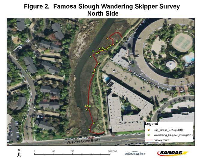
2 Introduction The wandering skipper (Panoquina errans) is a small butterfly of the family Hesperiidae. It is identifiable by its rich dark brown color and cream-colored spots on the dorsal forewing. The wandering skipper is found only along the coast in southern California, Baja California and northwestern mainland Mexico. Populations have been recorded from Huntington Beach, Upper Newport Bay, and Capistrano Beach (Orsak, 1977). In San Diego, the wandering skipper has been documented in the Tijuana Estuary, San Dieguito Lagoon, and Agua Hedionda lagoon (SanGIS, 2010), but it appears that no extensive survey data have been published. The wandering skipper is on the IUCN Red List of Threatened Species (World Conservation Monitoring Centre, 1996) and is under consideration for possible listing on the endangered species list as a threatened species because of the reduction of salt marsh habitat. The larval host plant for this species, salt grass (Distichlis spicata), is found in transitional habitats along the edge of the high marsh. Nectar sources include Heliotropium spp., Haplopappus spp., and Frankenia salina (Orsak 1977). Potential habitat for the wandering skipper was considered to be areas containing the larval host plant in close proximity to nectar plants. Surveys were completed to determine presence of the wandering skipper in potential habitat areas within Famosa Slough, San Diego, California, both north and south of West Point Loma Blvd. Methods The surveys were conducted on August 27, The first survey, in high marsh habitat south of W. Point Loma Blvd and along the eastern edge of the wetlands, was conducted between 1:25 p.m. and 2:05 p.m. A second survey, 2:14 p.m. to 2:40 p.m., was conducted north of W. Point Loma Blvd. Butterflies were detected using a Pollard walk (Pollard, 1977) with 2-3 observers moving along a line through potential habitat. Binoculars were used to aid visual identification. A handheld GPS unit (Garmin GPSMAP 60, WAAS enabled) was used to record the location of each individual detected; photos were taken when possible to confirm identification. Significant salt grass patches (typically > 5 m 2 ) were also recorded using the handheld GPS device. The observers were conscientious about not counting the same individual twice; they noted the direction of flight of the individual and one observer tracked any individuals that moved in the same direction of the observers. The observers felt that no individuals were double counted. Temperature and wind speed remained fairly constant for both surveys (73.6 F to 70.5 F and mi/hr). Both wind and temperature were ideal for the identification of the wandering skipper. Cloud cover was low during the first survey (15%) and cleared to 0% cover for the second survey. Results Fifty-eight individuals of wandering skipper were detected at Famosa Slough (Table 1). Thirty were detected on the south side of W. Point Loma Blvd (Figure 1) and 29 were detected on the north side (Figure 2). Individuals were detected mainly on salt grass and Frankenia, though some were also detected on pickleweed (Sarcocornia pacifica) and salty susan (Jaumea carnosa). Habitat quality was excellent with significant salt grass patches
3 (Table 2) found in close proximity to flowering Frankenia on both the south and north sides of W. Point Loma Blvd (Figures 3-4). This survey is not intended to be a comprehensive survey of the entire reserve, but can be added to surveys by others. References Orsak, L.J The Butterflies of Orange County. Center for Pathobiology Miscellaneous Publication #3. University of California Press, New York. 349 pp. Pollard, E A method for assessing changes in the abundance of butterflies. Biological Conservation., 12: SanGIS Digital sources: Natural Diversity Database and Sensitive Sighting Database World Conservation Monitoring Centre Panoquina errans IUCN Red List of Threatened Species. Downloaded on 13 Aug Table 1. Wandering Skipper Locations, Famosa Slough Observers: Keith Greer, Betsy Miller, and Kim Roeland Observation Point Date Time N (degrees) W (degrees) 1 8/27/2010 1: /27/2010 1: /27/2010 1: /27/2010 1: /27/2010 1: /27/2010 1: /27/2010 1: /27/2010 1: /27/2010 1: /27/2010 1: /27/2010 1: /27/2010 1: /27/2010 1: /27/2010 1: /27/2010 1: /27/2010 1: /27/2010 1: /27/2010 1: /27/2010 1: /27/2010 1: /27/2010 1: /27/2010 1: /27/2010 1: /27/2010 1:
4 25 8/27/2010 1: /27/2010 1: /27/2010 1: /27/2010 1: /27/2010 1: /27/2010 1: /27/2010 2: /27/2010 2: /27/2010 2: /27/2010 2: /27/2010 2: /27/2010 2: /27/2010 2: /27/2010 2: /27/2010 2: /27/2010 2: /27/2010 2: /27/2010 2: /27/2010 2: /27/2010 2: /27/2010 2: /27/2010 2: /27/2010 2: /27/2010 2: /27/2010 2: /27/2010 2: /27/2010 2: /27/2010 2: /27/2010 2: /27/2010 2: /27/2010 2: /27/2010 2: /27/2010 2: /27/2010 2: /27/2010 2: Table 2. Significant Salt Grass Patches, Famosa Slough Observers: Keith Greer, Betsy Miller and Kim Roeland Observation Point Date Time N (degrees) W (degrees) 1 8/27/2010 2: /27/2010 2: /27/2010 2: /27/2010 2: /27/2010 2:

5
6


7 Figure 3. Keith Greer recording location of wandering skipper with GPS, South Side, Famosa Slough, San Diego Figure 4. Betsy Miller observing wandering skippers in high quality habitat, North Side, Famosa Slough, San Diego
8 Wandering Skipper Survey at the Kendall-Frost Mission Bay Marsh Reserve, San Diego, California 27 August 2010 Observers: Keith Greer, Isabelle Kay, Betsy Miller, and Kim Roeland
9 Introduction The wandering skipper (Panoquina errans) is a small butterfly of the family Hesperiidae. It is identifiable by its rich dark brown color and cream-colored spots on the dorsal forewing. The wandering skipper is found only along the coast in southern California, Baja California and northwestern mainland Mexico. Populations have been recorded from Huntington Beach, Upper Newport Bay, and Capistrano Beach (Orsak, 1977). In San Diego, the wandering skipper has been documented in the Tijuana Estuary, San Dieguito Lagoon, and Agua Hedionda lagoon (SanGIS, 2010), but it appears that no extensive survey data have been published. The wandering skipper is on the IUCN Red List of Threatened Species (World Conservation Monitoring Centre, 1996) and is under consideration for possible listing on the endangered species list as a threatened species because of the reduction of salt marsh habitat. The larval host plant for this species, salt grass (Distichlis spicata), is found in transitional habitats along the edge of the high marsh. Nectar sources include Heliotropium spp., Haplopappus spp., and Frankenia salina (Orsak 1977). Potential habitat for the wandering skipper was considered to be areas containing the larval host plant in close proximity to nectar plants. Surveys were completed to determine presence of the wandering skipper in potential habitat areas within the Kendall-Frost Mission Bay Marsh Reserve, San Diego, California, in high salt marsh habitat near the field station, just north of Rose Creek, and at the Crown Point Restoration site. Methods The surveys were conducted on August 27, The first survey focused on areas near the field station and north of Rose Creek in high marsh habitat between 10:27 a.m. and 11:30 a.m. A second survey, 11:55 a.m. to 12:13 p.m., was conducted in the Crown Point Restoration site. Butterflies were detected using a Pollard walk (Pollard, 1977) with 2-4 observers moving along a line through potential habitat. Binoculars were used to aid visual identification. A handheld GPS unit (Garmin GPSMAP 60, WAAS enabled) was used to record the location of each individual detected; photos were taken when possible to confirm identification. Significant salt grass patches (typically > 5 m 2 ) were also recorded using the handheld GPS device. Temperature and wind speed remained fairly constant for both surveys (72.3 F to 71.7 F and mi/hr). Both wind and temperature were ideal for the identification of the wandering skipper. Initially cloud cover was 100%, and by the second survey, some clearing was occurring. Cloudy weather is typically not ideal for the wandering skipper survey; however, since many other species of skippers and other butterflies were observed, we determined that our detection of the wandering skipper was not impacted by the cloud cover. Results Two individuals of wandering skipper were detected at the Kendall-Frost Mission Bay Marsh on a berm near the field station (Figures 1-2 and Table 1). The two individuals were observed copulating. Salt grass was not observed in any significant patches greater than 5
10 m², though small amounts of salt grass were found near the sighting locations for the wandering skippers. No wandering skippers were detected near Rose Creek or at the second survey location at the Crown Point Restoration site. No salt grass was found at either location, though Frankenia and other nectaring plants were detected. The results indicate that salt grass is a critical element for the presence of the wandering skipper. Though flowering nectaring plants were available throughout the high marsh, the only location with wandering skipper was near salt grass. This survey is not intended to be a comprehensive survey of the entire reserve, but can be added to surveys by others. References Orsak, L.J The Butterflies of Orange County. Center for Pathobiology Miscellaneous Publication #3. University of California Press, New York. 349 pp. Pollard, E A method for assessing changes in the abundance of butterflies. Biological Conservation., 12: SanGIS Digital sources: Natural Diversity Database and Sensitive Sighting Database World Conservation Monitoring Centre Panoquina errans IUCN Red List of Threatened Species. Downloaded on 13 Aug Table 1. Wandering Skipper Locations, Kendall-Frost Marsh Observers: Keith Greer, Betsy Miller, Isabelle Kay, and Kim Roeland Observation Point Date Time N (degrees) W (degrees) 1 8/27/ : /27/ :

11

12

13 Figure 2. Habitat on berm where two wandering skippers were observed mating, Kendall- Frost Mission Bay Marsh Reserve, San Diego.

14 Wandering Skipper Survey at the Los Peñasqitos Lagoon, San Diego, California 19 August 2010 Observers: Keith Greer and Kim Roeland
15 Introduction The wandering skipper (Panoquina errans) is a small butterfly of the family Hesperiidae. It is identifiable by its rich dark brown color and cream-colored spots on the dorsal forewing. The wandering skipper is found only along the coast in southern California, Baja California and northwestern mainland Mexico. Populations have been recorded from Huntington Beach, Upper Newport Bay, and Capistrano Beach (Orsak, 1977). In San Diego, the wandering skipper has been documented in the Tijuana Estuary, San Dieguito Lagoon, and Agua Hedionda lagoon (SanGIS, 2010), but it appears that no extensive survey data have been published. The wandering skipper is on the IUCN Red List of Threatened Species (World Conservation Monitoring Centre, 1996) and is under consideration for possible listing on the endangered species list as a threatened species because of the reduction of salt marsh habitat. The larval host plant for this species, salt grass (Distichlis spicata), is found in transitional habitats along the edge of the high marsh. Nectar sources include Heliotropium spp., Haplopappus spp., and Frankenia salina (Orsak 1977). Frankenia can be found in the high marsh zone between uplands and pickleweed saltmarsh habitat. Potential habitat for the wandering skipper was considered to be areas containing the larval host plant in close proximity to nectar plants. Surveys were completed to determine presence of the wandering skipper in potential habitat areas within the Los Peñasquitos Lagoon, San Diego, California, in the east end of the lagoon east of the railroad line (east end survey), and in salt marsh habitat east of Torrey Pines State Beach North Parking Lot south of the beach entrance (west end survey). Methods The surveys were conducted on August 19, The first survey - east end survey - was conducted between 10:12 a.m. and 12:49 p.m. in high marsh habitat. Surveyors started near Interstate 5 at the Carmel Valley Road Bridge and walked west looping around the middle of the marsh and finishing near the City of San Diego s Pump Station 65 (Figure 1). The second survey, 1:50 p.m. to 3:01 p.m., passed through salt marsh habitat located near the railroad right-of-way at the Torrey Pines State Beach North Parking Lot (Figure 2). Butterflies were detected using a Pollard walk (Pollard, 1977) with two observers moving along a line through potential habitat. Binoculars were used to aid visual identification. A handheld GPS unit (Garmin GPSMAP 60, WAAS enabled) was used to record the location of each individual detected; photos were taken when possible to confirm identification. Significant salt grass patches (typically > 5 m 2 ) were also recorded using the handheld GPS device. The observers were conscience about not counting the same individual twice, by noting the direction of flight of the individual and having one observer track any individuals that moved in the same direction of the observers. The observers felt that no individuals were double counted. Temperature and wind speed remained fairly constant for both surveys (75.2 F to 81.7 F and mi/hr). Both wind and temperature were ideal for the identification of the wandering skipper. Results Thirty-nine individuals of wandering skipper were detected at the Los Peñasquitos Lagoon in the areas surveyed (Table 1). Though salt grass was often found mixed with nectar plants
16 and other transitional plants, seven significant salt grass patches were counted and recorded (Table 2 and Figures 1-2). East End Survey No wandering skippers were found in the east end survey area. In the southeastern portion of the lagoon, there were many patches of Frankenia, but there was not much salt grass in close proximity. Also, it was observed that Frankenia was past its peak blooming throughout much of the lagoon and heavily parasitized by salt marsh dodder (Cuscuta salina) (Figure 3). The Frankenia in the east end was also heavily invaded by non-native grasses (Lolium multiflorum and Polypogon spp.) (Figure 4). One large patch of salt grass co-occurring with Frankenia was surveyed north of Pump Station 65; however, no skippers were observed after an exhaustive effort. West End Survey Conversely, the survey in the west end yielded 39 individuals. This habitat contains large salt grass patches adjacent to and sometimes intermixed with the Frankenia. As in the east end, the Frankenia was past its peak bloom, but some flowering still existed (Figure 5). The wandering skippers were observed mainly on Frankenia, though some observations were made on salt grass, Heliotropium spp., Juncus acutus, and Salicornia virginica (=Sarcocornia pacifica). Observations on the latter two may have been just opportunistic resting compared to nectaring. The results indicate that in the right areas, the wandering skipper is abundant in Los Peñasquitos Lagoon. Anecdotal observation leads to the conclusion that salt grass and Frankenia in close proximity are key constitute elements of the wandering skipper habitat. Vegetative line transects to determine the composition of the species present would be instrumental to determine the species habitat preference. This survey is not intended to be a comprehensive survey of the entire lagoon, but can be added to surveys by others. Additional habitat appears to be present to the south of the beach entrance area, but signage indicates that the area is restricted. References Orsak, L.J The Butterflies of Orange County. Center for Pathobiology Miscellaneous Publication #3. University of California Press, New York. 349 pp. Pollard, E A method for assessing changes in the abundance of butterflies. Biological Conservation., 12: SanGIS Digital sources: Natural Diversity Database and Sensitive Sighting Database World Conservation Monitoring Centre Panoquina errans IUCN Red List of Threatened Species. Downloaded on 13 Aug 2010.
17 Table 1. Wandering Skipper Locations, Los Penasquitos Lagoon Observers: Keith Greer and Kim Roeland Observation Point Date Time N (degrees) W (degrees) 1 8/17/2010 1: /17/2010 2: /17/2010 2: /17/2010 2: /17/2010 2: /17/2010 2: /17/2010 2: /17/2010 2: /17/2010 2: /17/2010 2: /17/2010 2: /17/2010 2: /17/2010 2: /17/2010 2: /17/2010 2: /17/2010 2: /17/2010 2: /17/2010 2: /17/2010 2: /17/2010 2: /17/2010 2: /17/2010 2: /17/2010 2: /17/2010 2: /17/2010 2: /17/2010 2: /17/2010 2: /17/2010 2: /17/2010 2: /17/2010 2: /17/2010 2: /17/2010 2: /17/2010 2: /17/2010 2: /17/2010 2: /17/2010 2: /17/2010 3: /17/2010 3: /17/2010 3:
18 Table 2. Significant Salt Grass Patches, Los Penasquitos Lagoon Observers: Keith Greer and Kim Roeland Observation Point Date Time N (degrees) W (degrees) 1 8/19/ : /19/ : /19/2010 1: /19/2010 2: /19/2010 2: /19/2010 2: /19/2010 2:

19
20


, East End Survey, Los Peñasquitos")
21 Figure 3. Frankenia past peak bloom and heavily parasitized by salt marsh dodder (Cuscuta salina), East End Survey, Los Peñasquitos Lagoon Figure 4. Frankenia heavily invaded by non-native grasses (Lolium multiflorum and Polypogon spp), East End Survey, Los Peñasquitos Lagoon Figure 5. Keith Greer recording wandering skipper observation on GPS, West End Survey, Los Peñasquitos Lagoon

22 Wandering Skipper Survey at Sweetwater Marsh NWR San Diego, California 3 September 2010 Observers: Keith Greer, Kim Roeland, and Brain Collins
23 Introduction The wandering skipper (Panoquina errans) is a small butterfly of the family Hesperiidae. It is identifiable by its rich dark brown color and cream-colored spots on the dorsal forewing. The wandering skipper is found only along the coast in southern California, Baja California and northwestern mainland Mexico. Populations have been recorded from Huntington Beach, Upper Newport Bay, and Capistrano Beach (Orsak, 1977). In San Diego, the wandering skipper has been documented in the Tijuana Estuary, San Dieguito Lagoon, and Agua Hedionda lagoon (SanGIS, 2010), but it appears that no extensive survey data have been published. The wandering skipper is on the IUCN Red List of Threatened Species (World Conservation Monitoring Centre, 1996) and is under consideration for possible listing on the endangered species list as a threatened species because of the reduction of salt marsh habitat. The larval host plant for this species, salt grass (Distichlis spicata), is found in transitional habitats along the edge of the high marsh. Nectar sources include Heliotropium spp., Haplopappus spp., and Frankenia salina (Orsak 1977). Potential habitat for the wandering skipper was considered to be areas containing the larval host plant in close proximity to nectar plants. Surveys were completed to determine presence of the wandering skipper in potential habitat areas within areas of the Sweetwater Marsh National Wildlife Refuge (Figure 1). Methods The surveys were conducted on September 3, Four different areas of the marsh were surveyed as described below. Butterflies were detected using a Pollard walk (Pollard, 1977) with 2-3 observers moving along a line through potential habitat. Binoculars were used to aid visual identification. A handheld GPS unit (Garmin GPSMAP 60, WAAS enabled) was used to record the location of each individual detected; photos were taken when possible to confirm identification. Significant salt grass patches (typically > 5 m 2 ) were also recorded using the handheld GPS device. The observers were conscientious about not counting the same individual twice; they noted the direction of flight of the individual and one observer tracked any individuals that moved in the same direction of the observers. The observers felt that no individuals were double counted. Northeast Marsh Survey The first survey, in high marsh habitat west of Interstate 5 was conducted between 10:23 am and 11:17 am. The temperature was 23.8 C (74.8 F) with and average wind speed of 3.9 km/hr (2.4 mph). The cloud cover was 0%. Gunpowder Point Survey The second survey, located on Gunpowder Point adjacent to San Diego Bay was conducted between 11:35 am and 12:27 pm. The temperature was 20.3 C (68.5 F) with and average wind speed of 15.7 km/hr (9.8 mph). The cloud cover was 0%. Brain Collins was not available for this survey. 2
24 Nature Center Road The third survey, along the road leading to the nature center was conducted between 12:47 pm and 1:06 pm. The temperature was 21.7 C (71.0 F) with and average wind speed of km/hr (6.8 mph). The cloud cover was 0%. Brain Collins was not available for this survey. D-Street Fill The fourth and final survey, occurred in an artificial fill area annual maintained to remove vegetation for least terns. The survey was between 1:25 pm and 2:06 pm. The temperature was 24.6 C (76.2 F) with and average wind speed of 12.4 km/hr (7.7 mph). The cloud cover was 0%. Results Individuals of wandering skipper were detected at each survey area, but the densities were lower than in pervious surveys (e.g., Famosa Slough or San Elijo Lagoon) (Table 1). The habitat areas in the lagoon appear ideal with many locations of salt grass adjacent to large areas of Frankenia (see Figures 1-5). With the except of the D-Street Fill area the habitat looks as good as any other marsh found during past surveys in other lagoons. The lower densities maybe due the surveys occurring past the peak of the adult flight season which also corresponds with the lack of flower nectar sources. Alternatively the higher wind speed may have also affected the active flying and thus detection of adults. Both seem like reasonable hypothesizes for the results at Sweetwater marsh and surveys earlier in the season on less windy days would be recommended. Special comment must be made regarding the D-Street fill area. This location is groomed for open sand annual for least tern management. Salt grass was prolific (several acres) in these disturbed areas; however, little Frankenia was observed adjacent to the salt grass. What was observed was at least two wandering skippers occurring in a very large patch of Mesembryanthemum spp (Figure 5). It can not be confirmed that these individuals were nectaring or just resting. This is a plant that has not been mentioned as a nectaring source for wandering skippers, but the observers saw many species of other butterflies utilizing this area. Refuge manager, Brain Collins, netted an individual for pictures to support the identification of wandering skipper in this area (Figure 6). The D-Street Fill appears atypical of other wandering skipper areas and future work is recommended in this area. This survey is not intended to be a comprehensive survey of the entire reserve, but can be added to surveys by others. References Orsak, L.J The Butterflies of Orange County. Center for Pathobiology Miscellaneous Publication #3. University of California Press, New York. 349 pp. Pollard, E A method for assessing changes in the abundance of butterflies. Biological Conservation., 12: SanGIS Digital sources: Natural Diversity Database and Sensitive Sighting Database World Conservation Monitoring Centre Panoquina errans IUCN Red List of Threatened Species. Downloaded on 13 Aug
25 Table 1. Wandering Skipper Locations, Sweetwater Marsh Observers: Keith Greer, Kim Roeland and Brian Collins Observation Point Date Time N (decimal degrees) W (decimal degrees) 1 9/3/ : /3/ : /3/ : /3/ : /3/ : /3/ : /3/ : /3/ : /3/ : /3/2010 1: /3/2010 1: /3/2010 1: /3/2010 1: /3/2010 2: Table 2. Significant Salt Grass Patches, Sweetwater Marsh Observers: Keith Greer, Kim Roeland and Brain Collins Observation Point Date Time N (decimal degrees) W (decimal degrees) 1 9/3/2010 1: /3/ : /3/ : /3/ : /3/ : /3/ : /3/ : /3/ : /3/ : /3/2010 1: /3/ : /3/ : /3/ :

26 5

27 Figure 2. Wandering Skipper habitat at Gunpowder Point, Sweetwater National Wildlife Refuge 6

28 Figure 3. Typical plants in observed wandering skipper locations include large stands of salt grass adjacent to Frankenia in the upper marsh. 7

29 Figure 4: Brain Collins in typical wandering skipper habitat northeastern area of Sweetwater Marsh. 8

30 Figure 5: Atypically habitat at D-Street Fill. Large areas of salt grass occur with little to no Frankenia. Wandering skippers were observed on the Mesembryanthemum spp, but nectaring could not be confirmed. 9

31 Figure 6: Wandering skipper netted by Brain Collins in the atypically habitat of the D-Street Fill. Netting was done to confirm species identification and photo documentation for this report. The individual was released after photographs were taken. 10
Activity 3: Adult Monarch Survey
 Activity 3: Adult Monarch Survey Overview Participants establish an adult monarch survey route within the monitoring plot and count adult monarchs within defined spaces along the route, documenting their
R. Griswold Snowy Plover/Least Tern Monitoring Project 2009
 R. Griswold Snowy Plover/Least Tern Monitoring Project 2009 Identification California Least Tern Endangered 9-10 Nests in colonies Dives from air for fish Parents feed young Nesting colony can be fenced
GRADE2. Curriculum and Lesson Plan Resource Guide
 GRADE2 Curriculum and Lesson Plan Resource Guide Donald C. & Elizabeth M. Dickinson Foundation The Carol and Henry F. Hunte Fund at The San Diego Foundation Grade 2 Beaks and Bills Essential Question Why
A 2014 Survey of Butterflies at the Confluence *
 A 2014 Survey of Butterflies at the Confluence * By Eugene/Springfield North American Butterfly Association Summer 2014 Reported by David Hagen * The Confluence of the Middle and Coast forks of the Willamette
Los Angeles & Orange County Western Snowy Plover Monthly Report for February 2016
 Los Angeles & Orange County Western Snowy Plover Monthly Report for February 2016 Prepared for Nancy Frost California Department of Fish and Wildlife 3883 Ruffin Road San Diego, CA 92123 Prepared by: Los
Establishment of Additional Monarch Butterfly Host Plants at the Sand Hill Lakes Mitigation Bank
 Establishment of Additional Monarch Butterfly Host Plants at the Sand Hill Lakes Mitigation Bank David Clayton Environmental Scientist III David.Clayton@nwfwater.com Northwest Florida Water Management
Report to the Monarch Joint Venture Monitoring of Monarch Overwintering Sites in California 2013
 Report to the Monarch Joint Venture Monitoring of Monarch Overwintering Sites in California 2013 Overwintering monarch on eucalyptus, Santa Barbara County, CA. Photo by Candace Fallon / The Xerces Society
STATUS AND MANAGEMENT OF LIGHT-FOOTED CLAPPER RAILS IN COASTAL SOUTHERN CALIFORNIA
 STATUS AND MANAGEMENT OF LIGHT-FOOTED CLAPPER RAILS IN COASTAL SOUTHERN CALIFORNIA RICHARD ZEMBAL, U.S. Fish and Wildlife Service, 2730 Loker Avenue West. Carlsbad, CA 92008 1992 TRANSAcnDNS OF THE. WE.STERN
Collaboration and Planning to Implement the South San Diego Bay Restoration and Enhancement Project
 Collaboration and Planning to Implement the South San Diego Bay Restoration and Enhancement Project Carolyn Lieberman Coastal Program Coordinator for Southern California U.S. Fish and Wildlife Service
Species Response to Habitat Restoration and Management in San Francisco Bay
 Species Response to Habitat Restoration and Management in San Francisco Bay Joy Albertson, U.S. Fish and Wildlife Service October 11, 2017 2017 State of the San Francisco Estuary Conference Past (~1850)
NUTTALL S BUCKMOTH (Hemileuca nuttalli) AND GROUND MANTID (Litaneutria minor) SEARCHES IN THE SOUTH OKANAGAN VALLEY, BRITISH COLUMBIA, 2009
 AND GROUND MANTID (Litaneutria minor) SEARCHES IN THE SOUTH OKANAGAN VALLEY, BRITISH COLUMBIA, 2009") NUTTALL S BUCKMOTH (Hemileuca nuttalli) AND GROUND MANTID (Litaneutria minor) SEARCHES IN THE SOUTH OKANAGAN VALLEY, BRITISH COLUMBIA, 2009 By Vicky Young and Dawn Marks, BC Conservation Corps BC Ministry
NUTTALL S BUCKMOTH (Hemileuca nuttalli) AND GROUND MANTID (Litaneutria minor) SEARCHES IN THE SOUTH OKANAGAN VALLEY, BRITISH COLUMBIA, 2009 By Vicky Young and Dawn Marks, BC Conservation Corps BC Ministry
Apodemia mormo langei J. A. Comstock, 1938 Lange s Metalmark (Riodinidae: Riodininae)
") Black, S. H., and D. M. Vaughan. 2005. Species Profile: Apodemia mormo langei. In Shepherd, M. D., D. M. Vaughan, and S. H. Black (Eds). Red List of Pollinator Insects of North America. CD-ROM Version
Black, S. H., and D. M. Vaughan. 2005. Species Profile: Apodemia mormo langei. In Shepherd, M. D., D. M. Vaughan, and S. H. Black (Eds). Red List of Pollinator Insects of North America. CD-ROM Version
THE LIGHT-FOOTED CLAPPER RAIL: DISTRIBUTIONI NESTING STRATEGIESI AND MANAGEMENT
 THE LIGHT-FOOTED CLAPPER RAIL: DISTRIBUTIONI NESTING STRATEGIESI AND MANAGEMENT Richard Zembal U;S. Fish and Wildlife Service 24 Avila Road Laguna Niguel, California 92677 and Barbara W. Massey Biology
North American Wetlands Conservation Act
 North American Wetlands Conservation Act CALIFORNIA California currently has 151 NAWCA projects either completed or underway. These projects have conserved a total of 869,189 acres of wildlife habitat.
Eldrett Bird Conservation Area
 St. Lawrence Eastern Lake Ontario Partnership for Regional Invasive Species Management Eldrett Bird Conservation Area Early Detection Surveillance July 18-19, 2013 Figure 1: Panoramic view of Eldrett Bird
Natural Heritage Inventory and Evaluation for the Medway Valley Heritage Forest South ESA. Public Meeting January 27, 2014
 Natural Heritage Inventory and Evaluation for the Medway Valley Heritage Forest South ESA Welcome! Tonight you will have the opportunity to learn and comment on: Purpose of the Inventory and Evaluation
A Rooftop Bird Survey of Facebook's Living Roof Eighteen-Month Report
 Santa Clara Valley Audubon Society A Rooftop Bird Survey of Facebook's Living Roof Eighteen-Month Report Team: Mackenzie Mossing, Shani Kleinhaus, Ralph Schardt Santa Clara Valley Audubon Society Introduction
THE MERSEY GATEWAY PROJECT (MERSEY GATEWAY BRIDGE) AVIAN ECOLOGY SUMMARY PROOF OF EVIDENCE OF. Paul Oldfield
 AVIAN ECOLOGY SUMMARY PROOF OF EVIDENCE OF. Paul Oldfield") HBC/14/3S THE MERSEY GATEWAY PROJECT (MERSEY GATEWAY BRIDGE) AVIAN ECOLOGY SUMMARY PROOF OF EVIDENCE OF Paul Oldfield 1 1 DESCRIPTION OF THE BIRDLIFE IN THE UPPER MERSEY ESTUARY LOCAL WILDLIFE SITE 1.1
HBC/14/3S THE MERSEY GATEWAY PROJECT (MERSEY GATEWAY BRIDGE) AVIAN ECOLOGY SUMMARY PROOF OF EVIDENCE OF Paul Oldfield 1 1 DESCRIPTION OF THE BIRDLIFE IN THE UPPER MERSEY ESTUARY LOCAL WILDLIFE SITE 1.1
Advanced Scavenger Hunt
 2012 Start inside the Galleria! The Bay 1. Find a shark that hunts at night. 2. Find the large, bright orange fish (the state marine fish of California.) Write its name here: 3. How long can a spiny lobster
2. Survey Methodology
 Analysis of Butterfly Survey Data and Methodology from San Bruno Mountain Habitat Conservation Plan (1982 2000). 2. Survey Methodology Travis Longcore University of Southern California GIS Research Laboratory
California Least Tern & Western Snowy Plover Monitoring Project. Huntington State Beach Least Tern Natural Preserve A Partnership Since 2005
 California Least Tern & Western Snowy Plover Monitoring Project Huntington State Beach Least Tern Natural Preserve A Partnership Since 2005 Identification California Least Tern - CLTE Endangered 9-10 Nests
Siletz Bay BCS number: 47-29
 Siletz Bay BCS number: 47-29 ***NOTE: We were unable to determine all necessary information for this site description. If you would like to contribute the needed information to this description, please
APPENDIX G. Biological Resources Reports
 APPENDIX G Biological Resources Reports November 9, 2009 David Geiser Merlone Geier Management, LLC 3580 Carmel Mountain Rd., Suite 260 San Diego, California 92130 RE: Neighborhood at Deer Creek, Petaluma,
California Clapper Rail Surveys. San Francisco Estuary Invasive Spartina Project 2007
 California Clapper Rail Surveys for the San Francisco Estuary 2007 Arrowhead Marsh March 29, 2007 Prepared by: Hildie Spautz P. O. Box 2330 El Cerrito, CA 94530 Submitted to: Olofson Environmental, Inc.
18 July Keith Greer SANDAG 401 B Street, Suite 800 San Diego, CA Subject: Mission Bay Park Project Quarterly Report
 18 July 2012 Keith Greer SANDAG 401 B Street, Suite 800 San Diego, CA 92101 Subject: Mission Bay Park Project Quarterly Report Dates Reporting: April 6 th -July 6 th, 2012 Project Summary: The project
Peregrine Falcon Falco peregrinus
 Plant Composition and Density Mosaic Distance to Water Prey Populations Cliff Properties Minimum Patch Size Recommended Patch Size Home Range Photo by Christy Klinger Habitat Use Profile Habitats Used
Eastern Lake Ontario Dunes D-3 Assessment SLELO-PRISM Buckthorn and Swallow-wort Surveillance/Dune Willow Monitoring
 St. Lawrence Eastern Lake Ontario Partnership for Regional Invasive Species Management Eastern Lake Ontario Dunes D-3 Assessment Buckthorn and Swallow-wort Surveillance/Dune Willow Monitoring July 13 &
Oregon Dunes National Recreation Area BCS Number: 47-5
 Oregon Dunes National Recreation Area BCS Number: 47-5 ***NOTE: We were unable to determine all necessary information for this site description. If you would like to contribute the needed information to
Speyeria idalia (Drury), 1773 Regal Fritillary (Nymphalidae: Argynninae) SUMMARY
, 1773 Regal Fritillary (Nymphalidae: Argynninae) SUMMARY") Vaughan, D. M., and M. D. Shepherd. 2005. Species Profile: Speyeria idalia. In Shepherd, M. D., D. M. Vaughan, and S. H. Black (Eds). Red List of Pollinator Insects of North America. CD-ROM Version 1 (May
Vaughan, D. M., and M. D. Shepherd. 2005. Species Profile: Speyeria idalia. In Shepherd, M. D., D. M. Vaughan, and S. H. Black (Eds). Red List of Pollinator Insects of North America. CD-ROM Version 1 (May
Jackson Bottom Wetlands Preserve BCS Number: 47-14
 Jackson Bottom Wetlands Preserve BCS Number: 47-14 Site description author(s) Greg Gillson, Jackson Bottom Wetlands Preserve Primary contact for this site Ed Becker, Natural Resources Manager, Jackson
Santa Clara Valley Habitat Plan
 Santa Clara Valley Habitat Plan Joint Governing & Implementation Board Meeting Burrowing Owl Survey Summary and Fee Map January 15, 2015 29 1 Agenda Brief Overview of the Key Aspects of the Burrowing Owl
Citizen Science Strategy for Eyre Peninsula DRAFT
 Citizen Science Strategy for Eyre Peninsula 1 What is citizen science? Citizen science is the practice of professional researchers engaging with the public to collect or analyse data within a cooperative
2008 San Francisco Bay Shorebird Census
 2008 San Francisco Bay Shorebird Census San Francisco Bay is a great place for shorebirds! The salt ponds, tidal flats, marshes and seasonal wetlands provide important habitat for over a million resident
Mud Slough Wetland Reserve BCS number: 47-19
 Mud Slough Wetland Reserve BCS number: 47-19 ***NOTE: We were unable to determine all necessary information for this site description. If you would like to contribute the needed information to this description,
AERIAL SURVEY OF BIRDS AT MONO LAKE ON AUGUST 24, 1973
 AERIAL SURVEY OF BIRDS AT MONO LAKE ON AUGUST 24, 1973 by Ronald M. Jurek Special Wildlife Investigations Wildlife Management Branch California Department of Fish and Game September 1973 Jurek, R.M. 1973.
Aphrodite Fritillary. Speyeria aphrodite. Identifying characteristics. Similar species. Wisconsin Butterflies. butterflies tiger beetles robber flies
 Page 1 of 5 Wisconsin Butterflies butterflies tiger beetles robber flies Search species Aphrodite Fritillary Speyeria aphrodite The Aphrodite Fritillary is found throughout the state during much of July
Ferruginous Hawk Buteo regalis
 Photo by Teri Slatauski Habitat Use Profile Habitats Used in Nevada Sagebrush Pinyon-Juniper (Salt Desert Scrub) Key Habitat Parameters Plant Composition Sagebrush spp., juniper spp., upland grasses and
THE ROLE OF SCIENCE IN WESTERN GRAY SQUIRREL ENHANCEMENT IN OAK WOODLANDS OF SOUTH PUGET SOUND
 THE ROLE OF SCIENCE IN WESTERN GRAY SQUIRREL ENHANCEMENT IN OAK WOODLANDS OF SOUTH PUGET SOUND Sanders Freed, The Nature Conservancy of Washington, Olympia, WA; Cheryl Fimbel, The Nature Conservancy of
Walking In the Marsh: Methods to Increase Safety and Reduce Impacts to Wildlife/Plants
 Walking In the Marsh: Methods to Increase Safety and Reduce Impacts to Wildlife/Plants I. Safety A. Before heading out into the marsh check the tides: tides can affect your ability to move through the
Expansion Work Has Begun The perimeter dike for Cell 7 is now visible
 Summer/Fall 2017 In This Issue Poplar Island Expansion Wetland Cell 5AB Development Wildlife Update Birding tours on Poplar Island Expansion Work Has Begun The perimeter dike for Cell 7 is now visible
Work Plan for Pre-Construction Avian and Bat Surveys
 Work Plan for Pre-Construction Avian and Bat Surveys, Steuben County, New York Prepared For: EverPower Wind Holdings, Inc. 1251 Waterfront Place, 3rd Floor Pittsburgh, PA 15222 Prepared By: Stantec Consulting
Icaricia icarioides missionensis (Hovanitz), 1937 Mission Blue (Lycaenidae: Polyommatinae; Polyommatini)
, 1937 Mission Blue (Lycaenidae: Polyommatinae; Polyommatini)") Black, S. H., and D. M. Vaughan. 2005. Species Profile: Icaricia icarioides missionensis. In Shepherd, M. D., D. M. Vaughan, and S. H. Black (Eds). Red List of Pollinator Insects of North America. CD-ROM
Black, S. H., and D. M. Vaughan. 2005. Species Profile: Icaricia icarioides missionensis. In Shepherd, M. D., D. M. Vaughan, and S. H. Black (Eds). Red List of Pollinator Insects of North America. CD-ROM
Lesser Sandhill Cranes, Annual Summary Homer, Alaska, Summer By Kachemak Crane Watch
 Lesser Sandhill Cranes, Annual Summary Homer, Alaska, Summer 2016 By Kachemak Crane Watch This year s Sandhill Crane season started winding down on September 7 when roughly half of Homer s cranes took
Wetland Care Program. Student Field Journal
 Wetland Care Program Student Field Journal Name: Class: Wetland Care Program Student Field Journal 1 Topic 1 Native Plants vs. Weeds What is a weed? A weed is a plant growing where it is not native, and
CALIFORNIA NAWCA PROJECTS
 CALIFORNIA NAWCA S $100,277,613 $394,228,870 159 887,770 NAWCA GRANT AMOUNT TOTAL PARTNER CONTRIBUTION NUMBER OF S TOTAL ACRES California currently has 159 NAWCA projects either completed or underway.
Grassland Bird Survey Protocol Sauvie Island Wildlife Area
 Grassland Bird Survey Protocol Sauvie Island Wildlife Area Project Objective: Help determine if native grassland bird species are benefiting from restoration of grassland/pasture habitats at the Sauvie
Smith River Mouth BCS number: 86-6
 Smith River Mouth BCS number: 86-6 ***NOTE: We were unable to determine all necessary information for this site description. If you would like to contribute the needed information to this description,
PART FIVE: Grassland and Field Habitat Management
 PART FIVE: Grassland and Field Habitat Management PAGE 64 15. GRASSLAND HABITAT MANAGEMENT Some of Vermont s most imperiled birds rely on the fields that many Vermonters manage as part of homes and farms.
Backcountry Management. Anne Morkill Wildlife Refuge Manager U.S. Fish & Wildlife Service
 Backcountry Management Anne Morkill Wildlife Refuge Manager U.S. Fish & Wildlife Service Florida Keys National Marine Sanctuary Advisory Council Duck Key, FL February 21, 2012 Overview of National Wildlife
Cattle-Free for 10 Years!
 Cattle-Free for 10 Years! Big Whitney Meadow after a Decade of Rest From Cattle Impact Photographs and text produced by Todd Shuman, August, 2011. For more information, email Todd at tshublu@yahoo.com
2011 Wood River Wetland Yellow Rail (Coturnicops neveboracensis noveboracensis) Survey Report
 Survey Report") 2011 Wood River Wetland Yellow Rail (Coturnicops neveboracensis noveboracensis) Survey Report Project Description The Bureau of Land Management s Wood River Wetland is located in T34S-R 7 1/2E; the wetland
2011 Wood River Wetland Yellow Rail (Coturnicops neveboracensis noveboracensis) Survey Report Project Description The Bureau of Land Management s Wood River Wetland is located in T34S-R 7 1/2E; the wetland
French Creek Wildlife Management Area SLELO-PRISM Early Detection Surveillance August 13 and 14, 2013
 St. Lawrence Eastern Lake Ontario Partnership for Regional Invasive Species Management French Creek Wildlife Management Area Early Detection Surveillance August 13 and 14, 2013 Figure 1: Panoramic view
Atrytone arogos (Boisduval & LeConte), 1834 Arogos Skipper (Hesperiidae: Hesperiinae) SUMMARY
, 1834 Arogos Skipper (Hesperiidae: Hesperiinae) SUMMARY") Shepherd, M. D. 2005. Species Profile: Atrytone arogos. In Shepherd, M. D., D. M. Vaughan, and S. H. Black (Eds). Red List of Pollinator Insects of North America. CD-ROM Version 1 (May 2005). Portland,
Shepherd, M. D. 2005. Species Profile: Atrytone arogos. In Shepherd, M. D., D. M. Vaughan, and S. H. Black (Eds). Red List of Pollinator Insects of North America. CD-ROM Version 1 (May 2005). Portland,
The following protocols should begin as soon as feasible after identification of a diurnal roost (ideally that night):
:") PERSONNEL Qualified biologists 48, biological technicians, and any other individuals deemed qualified by a local USFWS FO may conduct emergence surveys for Indiana bats by following the protocols below.
PERSONNEL Qualified biologists 48, biological technicians, and any other individuals deemed qualified by a local USFWS FO may conduct emergence surveys for Indiana bats by following the protocols below.
wiatri.net/inventory/bbb
 wiatri.net/inventory/bbb WI Bumble Bees Need Your Help WI has 20 bumble bee species. 1 is federally endangered. 7 are state species of greatest conservation need. 3 are state species with information needs.
Beaver Island Archipelago: Invasive Species Control Final Report Submitted by:
 Beaver Island Archipelago: Invasive Species Control Final Report Submitted by: 4371 N Long Lake Rd Traverse City, MI 49684 wildlife@wildlifewetlands.com (231) 943-0762 Project Plan and Schedule 2014 Treatment
Baskett Slough National Wildlife Refuge BCS number: 47-4
 Baskett Slough National Wildlife Refuge BCS number: 47-4 Site description author(s) Daphne E. Swope, Research and Monitoring Team, Klamath Bird Observatory Primary contact for this site N/A Location (UTM)
Relicensing Study 3.5.1
 Relicensing Study 3.5.1 BASELINE INVENTORY OF WETLAND, RIPARIAN AND LITTORAL HABITAT IN THE TURNERS FALLS IMPOUNDMENT, AND ASSESSMENT OF OPERATIONAL IMPACTS ON SPECIAL-STATUS SPECIES Updated Study Report
Catalog of Upper Mississippi River and Great Lakes Region Joint Venture GIS Data March 2009 Version 1
 Catalog of Upper Mississippi River and Great Lakes Region Joint Venture GIS Data March 2009 Version 1 Compiled by: Bradly Potter Introduction This catalog contains descriptions of GIS data available from
Survey Protocol for the Yellow-billed Cuckoo Western Distinct Population Segment
 Survey Protocol for the Yellow-billed Cuckoo Western Distinct Population Segment Halterman, MD, MJ Johnson, JA Holmes, and SA Laymon. 2016. A Natural History Summary and Survey Protocol for the Western
National Fish and Wildlife Foundation Executive Summary for the American Oystercatcher Business Plan
 National Fish and Wildlife Foundation Executive Summary for the American Oystercatcher Business Plan October 26, 2008 AMOY Exec Sum Plan.indd 1 8/11/09 5:24:00 PM Colorado Native Fishes Upper Green River
COLIN MCRAE SELECT OF WORKS
 COLIN MCRAE SELECT OF WORKS People find it hard to believe that these aerial images of one of the world s most famous bodies of water can be so strikingly unusual and colorful. I am often asked if these
Ladd Marsh Wildlife Area BCS number: 49-3
 Oregon Coordinated Aquatic Bird Monitoring: Description of Important Aquatic Bird Site Ladd Marsh Wildlife Area BCS number: 49-3 Site description author M. Cathy Nowak, Ladd Marsh Wildlife Area Biologist
Regal Fritillary. Speyeria idalia. Identifying characteristics. Similar species. Wisconsin Butterflies. butterflies tiger beetles robber flies
 Page 1 of 6 Wisconsin Butterflies butterflies tiger beetles robber flies Search species Regal Fritillary Speyeria idalia The Regal Fritillary is considered one of the elite butterflies of the eastern United
Say s Phoebe Sayornis saya Conservation Profile
 Ed Harper Habitat Use Profile Habitats Used in California Grasslands, 1,2 open areas with bare ground, 3 agricultural areas 1 Key Habitat Parameters Plant Composition No plant affinities known. Plant Density
Oil Spill Funds and the Opportunities they Present for Galveston Bay
 Oil Spill Funds and the Opportunities they Present for Galveston Bay A presentation to Texas Environmental Grantmakers Group By Bob Stokes, President, Galveston Bay Foundation Friday, October 31, 2014
Working with wildlife A DAY IN THE LIFE
 EPA ACTIVITY WORKSHEET STUDENT PAGE 1 7 Theme Student Sheet. This is the story of a scientist and their work on a day to day basis. Objectives To give students an insight into the work of scientists and
Results of 2013 Radar Surveys on Hispaniola
 Results of 2013 Radar Surveys on Hispaniola Adam C Brown, Senior Biologist. Environmental Protection in the Caribbean. 200 Dr. MLK Jr. Blvd. Riviera Beach, Florida 33404 USA **Report for ABC Cooperative
BIRD READING ASSIGNMENT
 Ocean Connectors BIRD READING ASSIGNMENT To do before the field trip, in class or at home 1. Students will read Wetland Neighbors. The reading is available on the next page and online at http://oceanconnectors.org/resources.
Los Angeles & Orange County Western Snowy Plover Monthly Report for December 2014
 Los Angeles & Orange County Western Snowy Plover Monthly Report for December 2014 Prepared for Nancy Frost California Department of Fish and Wildlife 3883 Ruffin Road San Diego, CA 92123 Prepared by: Los
Great Yellow Bumblebee (Bombus distinguendus) ) in Ireland
 ) in Ireland") Great Yellow Bumblebee (Bombus distinguendus) ) in Ireland 2010 STATUS World distribution Palaearctic region Conservation status s Bombus distinguendus is showing a general decline across central Europe.
Great Yellow Bumblebee (Bombus distinguendus) ) in Ireland 2010 STATUS World distribution Palaearctic region Conservation status s Bombus distinguendus is showing a general decline across central Europe.
Chaumont Bay SLELO-PRISM Water Chestnut & Hydrilla Surveillance 2012
 St. Lawrence Eastern Lake Ontario Partnership for Regional Invasive Species Management Chaumont Bay & Hydrilla Surveillance 2012 July 3, 5, 6 & 10 (Water Chestut); August 9 & 13 (Hydrilla), 2012 Figure
Party With a Purpose: MARSTEL-DAY GREEN GALA
 Party With a Purpose: MARSTEL-DAY GREEN GALA Tree Fredericksburg Eastern Shore Virginia I Featherstone I Fisherman Island I James River I Mason Neck Nansemond I Occoquan Bay I Plum Tree Island I Presquile
Update on American Oystercatcher Reseach and Conservation in New Jersey
 Update on American Oystercatcher Reseach and Conservation in New Jersey - 2007 Todd Pover, New Jersey Division of Fish and Wildlife - Endangered and Nongame Species Program Tom Virzi, PhD Candidate Department
Silver Lake Glossy Buckthorn Field Report. September-October 2012
 Silver Lake Glossy Buckthorn Field Report September-October 2012 Submitted by George Spak and Sandra Bonanno Introduction/Background Silver Lake is a spring fed glacial pothole in western Oswego County.
Charette Vision #1 for 2050
 Charette Vision #1 for 2050 Bird use? mercury? Charette Vision #2 for 2050 Important Uncertainties Mercury Sediment Dynamics/Mudflats Bird Use of Different Habitats, esp. tidal marsh ponds/pannes Non-avian
An Introduction To Southern California Butterflies By Herbert Clarke, Fred Heath READ ONLINE
 An Introduction To Southern California Butterflies By Herbert Clarke, Fred Heath READ ONLINE An Introduction to Southern California Butterflies. $10.61. Free shipping. Details about An introduction to
WILDLIFE MONITORING FOR THE COLLABORATIVE FOREST RESTORATION PROGRAM Protocols for Monitoring Birds, Turkey, Deer and Elk
 WILDLIFE MONITORING FOR THE COLLABORATIVE FOREST RESTORATION PROGRAM Protocols for Monitoring Birds, Turkey, Deer and Elk David Parsons Melissa Savage January 2008 New Mexico Forest Restoration Series
Least Bell's Vireo & Western Burrowing Owl Surveys
 I - 15 CORRIDOR CAMPUS MASTER PLAN DRAFT EIR MT. SAN JACINTO COMMUNITY COLLEGE DISTRICT Appendices Appendix D5 Least Bell's Vireo & Western Burrowing Owl Surveys August 2017 I - 15 CORRIDOR CAMPUS MASTER
Managing wetlands and rice to improve habitat for shorebirds and other waterbirds
 Managing wetlands and rice to improve habitat for shorebirds and other waterbirds Matthew E. Reiter Point Blue Conservation Science Wetland Management Workshop Sacramento National Wildlife Refuge May 9,
Tahkenitch Creek Estuary BCS number: 47-35
 Tahkenitch Creek Estuary BCS number: 47-35 ***NOTE: We were unable to determine all necessary information for this site description. If you would like to contribute the needed information to this description,
FIELD SURVEYS FOR MOUNTAIN PLOVERS (Charadrius montanus) IN THE CASPER FIELD OFFICE REGION
 IN THE CASPER FIELD OFFICE REGION") FIELD SURVEYS FOR MOUNTAIN PLOVERS (Charadrius montanus) IN THE CASPER FIELD OFFICE REGION Report prepared by: Dr. Gary P. Beauvais, Director Wyoming Natural Diversity Database University of Wyoming Laramie,
FIELD SURVEYS FOR MOUNTAIN PLOVERS (Charadrius montanus) IN THE CASPER FIELD OFFICE REGION Report prepared by: Dr. Gary P. Beauvais, Director Wyoming Natural Diversity Database University of Wyoming Laramie,
HERON AND EGRET MONITORING RESULTS AT WEST MARIN ISLAND: 2003 NESTING SEASON
 HERON AND EGRET MONITORING RESULTS AT WEST MARIN ISLAND: 2003 NESTING SEASON A Report to the San Pablo Bay National Wildlife Refuge John P. Kelly a and Binny Fischer Cypress Grove Research Center, Audubon
Florida Keys National Wildlife Refuge Complex. Key West NWR Great White Heron NWR National Key Deer NWR Crocodile Lake NWR
 Florida Keys National Wildlife Refuge Complex Key West NWR Great White Heron NWR National Key Deer NWR Crocodile Lake NWR Key West NWR Marquesas Keys and 13 other keys Mission as a preserve and protect
Butterfly Monitoring BECOMING A CITIZEN SCIENTIST
 Butterfly Monitoring BECOMING A CITIZEN SCIENTIST VOCABULARY OBJECTIVES BACKGROUND Nationwide, butterfly counts have become extremely popular for families, schools, and hobbyists alike. Not only do they
A 2010 Survey of Butterflies at Two West Eugene Wetlands Sites
 A 1 Survey of Butterflies at Two West Eugene Wetlands Sites By Eugene/Springfield North American Butterfly Association Summer 1 Reported by David & Lois Hagen Dragonfly Bend David Hagen A 1 Survey of Butterflies
Roberts Bank Terminal 2 Project Field Studies Information Sheet
 July 2012 Port Metro Vancouver is continuing field studies in July as part of ongoing environmental and technical work for the proposed Roberts Bank Terminal 2 Project. Roberts Bank Terminal 2 Project
The Quail Valley study area is located in the hills surrounding Railroad Canyon Reservoir, approximately 4 miles east of Lake Elsinore.
 County of Riverside - PSEC Project General Habitat Assessment Appendix A Quail Valley Quail Valley The Quail Valley study area is located in the hills surrounding Railroad Canyon Reservoir, approximately
WILDLIFE SURVEY OCTOBER DECEMBER
 WILDLIFE SURVEY OCTOBER DECEMBER 2013 Upper picture - Comma butterfly Lower picture - Peacock butterfly Butterflies taking advantage of the sun and ivy flowers in the first days of November Butterfly Survey
BV-24A DMMA Florida Scrub-Jay Survey Brevard County
 REPORT BV-24A DMMA Florida Scrub-Jay Survey Brevard County Submitted to: David L. Stites, Ph.D. Director of Environmental Services Taylor Engineering, Inc. 10199 Southside Blvd Suite 310 Jacksonville,
Mitoura hesseli Rawson & Ziegler, 1950 Hessel s Hairstreak (Lycaenidae: Theclinae: Eumaeini) SUMMARY
 SUMMARY") Vaughan, D. M., and M. D. Shepherd. 2005. Species Profile: Mitoura hesseli. In Shepherd, M. D., D. M. Vaughan, and S. H. Black (Eds). Red List of Pollinator Insects of North America. CD-ROM Version 1 (May
Vaughan, D. M., and M. D. Shepherd. 2005. Species Profile: Mitoura hesseli. In Shepherd, M. D., D. M. Vaughan, and S. H. Black (Eds). Red List of Pollinator Insects of North America. CD-ROM Version 1 (May
The contribution to population growth of alternative spring re-colonization strategies of Monarch butterflies (Danaus plexippus)
") The contribution to population growth of alternative spring re-colonization strategies of Monarch butterflies (Danaus plexippus) Explorers Club Fund for Exploration 2011 Grant Report D.T. Tyler Flockhart
The contribution to population growth of alternative spring re-colonization strategies of Monarch butterflies (Danaus plexippus) Explorers Club Fund for Exploration 2011 Grant Report D.T. Tyler Flockhart
Survey Results for the Coronis Fritillary in Southwest Oregon 2011
 Introduction Survey Results for the Coronis Fritillary in Southwest Oregon 2011 Jason Reilly, Wildlife Biologist, Ashland Resource Area, Medford BLM Scott Hoffman Black, Executive Director, Xerces Society
McNabney Marsh Nesting Bird Surveys
 McNabney Marsh 2014 Nesting Bird Surveys Prepared for: Mt View Sanitary District PO Box 2757 Martinez, CA 94553 Contact: Kelly Davidson 925.228.5635 Prepared by: PO Box 188888 Sacramento, CA 95818 Contact:
COASTAL CONSERVANCY. Staff Recommendation May 27, 2010 BAYSIDE BIRDING AND WALKING TRAIL. File No Project Manager: Megan Cooper
 COASTAL CONSERVANCY Staff Recommendation May 27, 2010 BAYSIDE BIRDING AND WALKING TRAIL File No. 08-152-01 Project Manager: Megan Cooper RECOMMENDED ACTION: Authorization to disburse an amount not to exceed
Speyeria zerene hippolyta (W. H. Edwards) 1879 Oregon Silverspot (Nymphalidae: Argynninae) SUMMARY
 1879 Oregon Silverspot (Nymphalidae: Argynninae) SUMMARY") Black, S. H., and D. M. Vaughan. 2005. Species Profile: Speyeria zerene hippolyta. In Shepherd, M. D., D. M. Vaughan, and S. H. Black (Eds). Red List of Pollinator Insects of North America. CD-ROM Version
Black, S. H., and D. M. Vaughan. 2005. Species Profile: Speyeria zerene hippolyta. In Shepherd, M. D., D. M. Vaughan, and S. H. Black (Eds). Red List of Pollinator Insects of North America. CD-ROM Version
Massachusetts Grassland Bird Conservation. Intro to the problem What s known Your ideas
 Massachusetts Grassland Bird Conservation Intro to the problem What s known Your ideas Eastern Meadowlark Bobolink Savannah Sparrow Grasshopper Sparrow Upland Sandpiper Vesper Sparrow Eastern Meadowlark
ASSESSING HABITAT QUALITY FOR PRIORITY WILDLIFE SPECIES IN COLORADO WETLANDS
 C O L O R A D O P A R K S Dabbling Ducks & W I L D L I F E GADWALL TOM KOERNER, USFWS / AMERICAN WIGEON BILL GRACEY NORTHERN PINTAIL GEORGIA HART / MALLARD MICHAEL MENEFEE, CNHP / ALL TEAL PHOTOS TOM KOERNER,
Humboldt Bay NWR BCS number: 86-4
 Humboldt Bay NWR BCS number: 86-4 ***NOTE: We were unable to determine all necessary information for this site description. If you would like to contribute the needed information to this description, please
Bald Eagle Annual Report February 1, 2016
 Bald Eagle Annual Report 2015 February 1, 2016 This page intentionally blank. PROJECT SUMMARY Project Title: Bald Eagle HCP Monitoring Subject Area: Habitat Conservation Plan (HCP) monitoring Date initiated: