AERIAL SURVEY OF BIRDS AT MONO LAKE ON AUGUST 24, 1973
|
|
|
- Willis Atkinson
- 6 years ago
- Views:
Transcription
1 AERIAL SURVEY OF BIRDS AT MONO LAKE ON AUGUST 24, 1973 by Ronald M. Jurek Special Wildlife Investigations Wildlife Management Branch California Department of Fish and Game September 1973 Jurek, R.M Aerial survey of birds at Mono Lake on August 24, Calif. Dep. of Fish and Game, Wildlife Management Branch, Special Wildlife Investigations report. Sacramento, CA. 4 pp. + map.
2 AERIAL SURVEY OF BIRDS AT MONO LAKE Introduction An aerial survey of birds at Mono Lake was conducted on August 24, 1973 at about the peak of the fall migration season. Purposes of the flight were as follows: 1) to determine if aerial surveys are practicable in counting water birds, particularly eared grebes and phalaropes, on Mono Lake; 2) to compare aerial counts with sample ground counts; and 3) to determine distribution of each species in relation to habitat types and regions of the lake. Methods The main species under consideration were California gulls, eared grebes, American avocets, northern phalaropes and Wilson s phalaropes. Killdeer, waterfowl and other species were counted only incidentally; no effort was made to seek out and survey these species in habitats around the lake. The aerial survey was preceded by sample counts from the shore on August 23. Water birds were censused at the Mono Marina shorebird census site (S5 26 l) and at the South Boat Ramp site (S5-26 3) (Figure 1). These stations are part of the California Shorebird Survey network of census sites. Because of the lowering water level of the lake, the South Boat Ramp site cannot be as accurately censused now as in previous years. Thus, only half the site was surveyed for this study. The Mono Marina site encompasses O.64 km (0.4 mile) of shoreline and 26.3 hectares (65 acres) of water. Offshore in shallow water are boulder and tufa tower outcroppings. The area censused at the South Boat Ramp site includes 0.4 km (0.25 mile) of shoreline and 14.2 hectares (35 acres) of water. Numerous tufa towers are exposed along the shoreline. Both counts were conducted by Morris P. Anderson and Ronald M. Jurek using binoculars and a 20x spotting scope. The aerial survey was flown in the Department s Cessna 185, piloted by Bob Powers. The observers, Anderson and Jurek, recorded counts on tape recorders. During the flight there was no wind and the sky was clear. The survey began at 0811 and ended at Shoreline counts from the air were conducted along the perimeter of the lake and around the islands (Figure 1). Included in counts were birds on the shore and on the water out to a distance of 0.4 km (1/4 mile) from shorelines. This part of the survey was flown at an altitude of 300 feet and at a distance of approximately 0.2 km (1/8 mile) from the shorelines. A special aerial count of grebes and gulls on open water was conducted at the west end of the lake (Figure 1). Included were birds on open water beyond 0.2 km (1/8 mile) from shorelines. Transect lines totaled l4.5 km (9 miles). Observers counted birds out to a distance of 0.2 km (1/8 mile) on each side of transect lines. Since voice counts failed to be registered on one recorder, the census width was 0.2 km (1/8 mile). Total coverage was 2.91 sq. km (720 acres).
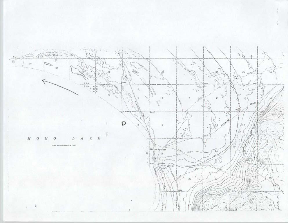
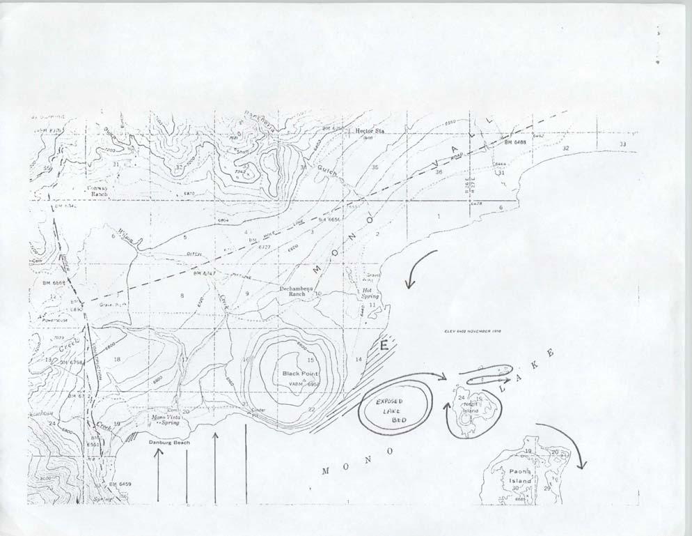
3 Results and Discussion Calculations from aerial counts indicate that approximately one half million water birds were on Mono Lake the morning of the count. Most of these were eared grebes. Along shorelines, 42,800 birds were counted (Table 1). Count figures for gulls and avocets are probably quite accurate, but those for phalaropes are undoubtedly too low. Because grebes dived as the plane approached, they could not be counted. Only a partial count was obtained around Paoha Island since voice counts were not registered on one tape recorder. Fortunately most of the birds around the island were included in the counts on the operative recorder. Probably only a couple hundred birds (gulls and phalaropes) were missed. TABLE 1 Aerial Counts of Birds Along Shorelines of Mono Lake, August 24, 1973 Area 1 Approximate Length of Shoreline Kilometers Miles California gull Species American avocet Phalaropes Southwest shore (A-B) , South shore (B-C) , East shore (C-D) , North shore (D-E) , Northwest shore (E-A) ,950 1,383 3,517 Exposed lake bed , Islets ,825 Negit Island Paoha Island Total ,090 4,030 8,680 1 Refer to Figure 1. 2 Partial census. On the open water transect, 3,961 eared grebes and 199 California gulls were counted. Many more grebes were excluded from this total since those feeding underwater could not be seen by observers. Densities of visible birds were 1,361 grebes per sq. km (3521 per square mile) and 68 gulls per sq. km (177 per square mile). Excluding portions of the lake within 0.2 km (1/8 mile) of shoreline, there are approximately 181 sq. km (70 square miles) of open water at Mono Lake. The estimated populations on open water are 246,470 grebes (surface count only) and 12,390 gulls. 2
4 To arrive at a total grebe population, the percentage of birds underwater at any moment must be known. At Mono Marina two hours before the aerial survey, approximately 40 percent of the grebes were feeding underwater at any given moment. Assuming that the grebes counted on the aerial survey represented only 60 percent of those actually in the transect area, the total population of eared grebes on the lake was approximately 411,000. Approximately 42,500 California gulls were present at Mono Lake on count day. Most of these, about 71 percent, were near shorelines. Juveniles were very rare along the south and west shores. They were more common on the east and north shores and were particularly numerous around the islands. American avocets occurred mainly where there were tufa towers. Of the 3,905 avocets counted, approximately 68 percent were found on the shore east of Black Point and around a fairly recently exposed portion of the lake bed west of Negit Island. Phalaropes were found chiefly in areas with tufa towers and around the islets northeast of Negit Island. Phalaropes were easily counted if they were flying or were swimming in open water. However, those among tufa towers or wading along shorelines were not accurately censused. The total count of 8,680 phalaropes may be less than half the actual figure. From the air, observers were able to distinguish species of phalaropes only when the birds were flying. All phalaropes identified to species in open water areas were northern phalaropes. Nearer shore, where both Wilson s and northern phalaropes occur, species identification was not possible. Most of the phalaropes sighted were near land in the west half of the lake. Of those counted, 90 percent were around the islands and along the lake shore from Hot Springs to the area northeast of North Crater. Tufa tower habitat east of Black Point and the islets northeast of Negit Island were the main concentration areas where 62 percent of all phalaropes were observed. Other species recorded included a flock of 100 ruddy ducks near the lake shore north of Negit Island. Killdeer were sighted in small numbers around the lake, but they were difficult to census. Eight species of water birds were recorded at the two shoreline census sites (Table 2). Only for grebes and gulls can aerial and ground population data be compared. No attempt is made to compare the two survey methods with respect to avocet and phalarope populations. Survey comparisons would not be meaningful because avocets are quite rare at the two south shore sites and phalaropes were not accurately censused from the air. Combining counts at both ground survey sites, density of grebes was 2,743 birds per sq. km (7,104 per square mile) of lake surface. This is about twice the density estimated from the air: 1,361 grebes per sq. km (3,521 per square mile). Again, these are figures only for the number of grebes visible on the surface at any given moment. Density of gulls at ground stations was 428 birds per km (685 per mile) of shoreline. This density is close to that determined by aerial counts along shorelines: 398 gulls per km (640 per mile). Ronald M. Jurek Assistant Wildlife Manager Biologist 3-
5 TABLE 2 Ground Counts of Birds at Mono Lake, August 23, 1973 Number of Birds Species Mono Marina (S5-26-1) 1 South Boat Ramp (S5-26-3) 2 Killdeer 2 2 Least sandpiper - 20 Western sandpiper 7 - America avocet 2 2 Wilson s phalarope Northern phalarope California gull Eared grebe Total 1, Wind: 10 m.p.h., sky: clear, time: Wind: 15 m.p.h., sky: clear, time:
6
7
8
9
2008 San Francisco Bay Shorebird Census
 2008 San Francisco Bay Shorebird Census San Francisco Bay is a great place for shorebirds! The salt ponds, tidal flats, marshes and seasonal wetlands provide important habitat for over a million resident
DISTRIBUTION AND ABUNDANCE OF SEA DUCKS AND DIVING DUCKS ON LAKE ST. CLAIR AND W. LAKE ERIE
 DISTRIBUTION AND ABUNDANCE OF SEA DUCKS AND DIVING DUCKS ON LAKE ST. CLAIR AND W. LAKE ERIE Dave Luukkonen, Michigan DNR and Michigan State University Importance of Lake St. Clair and western Lake Erie
Alvord Lake BCS number: 48-2
 Oregon Coordinated Aquatic Bird Monitoring: Description of Important Aquatic Bird Site Alvord Lake BCS number: 48-2 Site description author(s) Whitney Haskell, Data Management Intern, Klamath Bird Observatory
THE SHOREBIRDS OF MONTEZUMA NATIONAL WILDLIFE REFUGE
 THE SHOREBIRDS OF MONTEZUMA NATIONAL WILDLIFE REFUGE I have birded the Montezuma National Wildlife Refuge for twentyfive years, with shorebirds as my special interest. Over the past sixteen years I have
Sauvie Island Wildlife Area BCS number: 47-28
 Sauvie Island Wildlife Area BCS number: 47-28 Site description author(s) Mark Nebeker, Oregon Department of Fish and Wildlife, Sauvie Island Wildlife Area Manager Primary contact for this site Mark Nebeker,
Tualatin River NWR and Wapato Lake BCS number: 47-37
 Tualatin River NWR and Wapato Lake BCS number: 47-37 ***NOTE: We were unable to determine all necessary information for this site description. If you would like to contribute the needed information to
Ladd Marsh Wildlife Area BCS number: 49-3
 Oregon Coordinated Aquatic Bird Monitoring: Description of Important Aquatic Bird Site Ladd Marsh Wildlife Area BCS number: 49-3 Site description author M. Cathy Nowak, Ladd Marsh Wildlife Area Biologist
Roberts Bank Terminal 2 Project Field Studies Information Sheet
 January 2013 Port Metro Vancouver is continuing field studies in January as part of ongoing environmental and technical work for the proposed. The is a proposed new multi berth container terminal which
POPULATION SIZE AND REPRODUCTIVE SUCCESS OF CALIFORNIA GULLS AT MONO LAKE, CALIFORNIA, IN 1995, WITH EMPHASIS ON THE NEGIT ISLETS
 POPULATION SIZE AND REPRODUCTIVE SUCCESS OF CALIFORNIA GULLS AT MONO LAKE, CALIFORNIA, IN 1995, WITH EMPHASIS ON THE NEGIT ISLETS W. David Shuford and Al DeMartini Report of Point Reyes Bird Observatory
2016 WATERFOWL BREEDING POPULATION SURVEY MINNESOTA
 2016 WATERFOWL BREEDING POPULATION SURVEY MINNESOTA TITLE: Waterfowl Breeding Population Survey for Minnesota STRATA SURVEYED: Minnesota Strata 1, 2, and 3 DATES: May 2-May 16, 2016 DATA SUPPLIED BY: Minnesota
River s End Ranch BCS number: 48-21
 Oregon Coordinated Aquatic Bird Monitoring: Description of Important Aquatic Bird Site River s End Ranch BCS number: 48-21 Site description author(s) Martin St. Lewis, Area Manager, Summer Lake Wildlife
Roberts Bank Terminal 2 Project Field Studies Information Sheet
 July 2012 Port Metro Vancouver is continuing field studies in July as part of ongoing environmental and technical work for the proposed Roberts Bank Terminal 2 Project. Roberts Bank Terminal 2 Project
44. MARINE WILDLIFE Introduction Results and Discussion. Marine Wildlife Cook Inlet
 44. MARINE WILDLIFE 44.1 Introduction This study examined the distribution and abundance of marine-oriented wildlife (birds and mammals) during surveys conducted by ABR, Inc. Environmental Research & Services.
Warner Wetlands / Warner Valley BCS number: 48-31
 Oregon Coordinated Aquatic Bird Monitoring: Description of Important Aquatic Bird Site Warner Wetlands / Warner Valley BCS number: 48-31 Site description author(s) Vernon Stofleth, Lakeview BLM District
2018 WATERFOWL BREEDING POPULATION SURVEY, MINNESOTA
 2018 WATERFOWL BREEDING POPULATION SURVEY, MINNESOTA TITLE: Waterfowl Breeding Population Survey for Minnesota STRATA SURVEYED: Minnesota Strata 1, 2, and 3 DATES: May 7-21, 2018 DATA SUPPLIED BY: Minnesota
May 25, 2005 Forum Meeting
 Photos by Peter LaTourrette and PRBO Effects of South San Francisco Bay Habitat Restoration on ing the Effects of Birds Restoration on South San Francisco Bay Bird Communities Nils Warnock, PhD; Diana
Species: Birds (seabirds, shorebirds, waterfowl, raptors, passerines) and marine mammals
 and marine mammals") Circumnavigation surveys Wildlife Inventory Plan Alaska Maritime National Wildlife Refuge Protocol #22 Version 1.2 Parameter: Populations (and occasionally boom-or-bust productivity) Species: Birds (seabirds,
Circumnavigation surveys Wildlife Inventory Plan Alaska Maritime National Wildlife Refuge Protocol #22 Version 1.2 Parameter: Populations (and occasionally boom-or-bust productivity) Species: Birds (seabirds,
IBA Monitoring Guide
 IBA Monitoring Guide Introduction The Important Bird Area (IBA) Program was launched by Audubon Arkansas in 2001 to create an inventory of critical bird breeding, wintering, and migratory stopover areas
Summaries of Sub-regional Trends in Density Indices PROCEEDINGS 1
 Trends Observed for Selected Marine Bird Species during 1993- Winter Aerial Surveys, Conducted by the PSAMP Bird Component (WDFW) in the Inner Marine Waters of Washington State David R. Nysewander, Joseph
Klamath Marsh National Wildlife Refuge BCS number: 48-16
 Oregon Coordinated Aquatic Bird Monitoring: Description of Important Aquatic Bird Site Klamath Marsh National Wildlife Refuge BCS number: 48-16 Site description author(s) Carol Damberg, Klamath Marsh NWR
Grassland Bird Survey Protocol Sauvie Island Wildlife Area
 Grassland Bird Survey Protocol Sauvie Island Wildlife Area Project Objective: Help determine if native grassland bird species are benefiting from restoration of grassland/pasture habitats at the Sauvie
Fall 2001 Whooping Crane Migrational Survey Protocol Implementation Report
 Fall 2001 Whooping Crane Migrational Survey Protocol Implementation Report Prepared by Executive Director s Office For Committee s of the Platte River Cooperative Agreement June 5, 2002 I. Introduction
McKay Creek National Wildlife Refuge BCS number: 48-19
 Oregon Coordinated Aquatic Bird Monitoring: Description of Important Aquatic Bird Site McKay Creek National Wildlife Refuge BCS number: 48-19 Site description author(s) Howard Browers, Supervisory Wildlife
Expansion Work Has Begun The perimeter dike for Cell 7 is now visible
 Summer/Fall 2017 In This Issue Poplar Island Expansion Wetland Cell 5AB Development Wildlife Update Birding tours on Poplar Island Expansion Work Has Begun The perimeter dike for Cell 7 is now visible
Upper Klamath National Wildlife Refuge Complex Upper Klamath Unit and Hank s Marsh Unit BCS Number: 48-29
 Oregon Coordinated Aquatic Bird Monitoring: Description of Important Aquatic Bird Site Upper Klamath National Wildlife Refuge Complex Upper Klamath Unit and Hank s Marsh Unit BCS Number: 48-29 Site description
A volunteer-based program for the study of international migrations of shorebirds in the Western Hemisphere
 Estuary and inlet sandbars: an important wildlife resource Exemplified with counts from the International Shorebird Surveys Brian Harrington Manomet Center for Conservation Sciences The International Shorebird
5.3 Developing Spatially-Explicit Models to Guide Conservation of Diving Ducks During Migration
 5.3 Developing Spatially-Explicit Models to Guide Conservation of Diving Ducks During Migration Introduction Historically, Lake St. Clair and western Lake Erie hosted an estimated 250,000 to 750,000 diving
Minnesota Loon Monitoring Program
 Minnesota Loon Monitoring Program Minnesota Department of Natural Resources Nongame Wildlife Program INSTRUCTIONS WELCOME!!! Thank you very much for participating in this year s Minnesota Loon Monitoring
AERIAL SURVEY OF EMPEROR GEESE AND OTHER WATERBIRDS SOUTHWESTERN ALASKA, FALL 2003
 AERIAL SURVEY OF EMPEROR GEESE AND OTHER WATERBIRDS IN SOUTHWESTERN ALASKA, FALL 2003 Edward J. Mallek 1 and Christian P. Dau 2 November 2003 1 U. S. Fish and Wildlife Service 2 U. S. Fish and Wildlife
Work Plan for Pre-Construction Avian and Bat Surveys
 Work Plan for Pre-Construction Avian and Bat Surveys, Steuben County, New York Prepared For: EverPower Wind Holdings, Inc. 1251 Waterfront Place, 3rd Floor Pittsburgh, PA 15222 Prepared By: Stantec Consulting
HERON AND EGRET MONITORING RESULTS AT WEST MARIN ISLAND: 2003 NESTING SEASON
 HERON AND EGRET MONITORING RESULTS AT WEST MARIN ISLAND: 2003 NESTING SEASON A Report to the San Pablo Bay National Wildlife Refuge John P. Kelly a and Binny Fischer Cypress Grove Research Center, Audubon
Baskett Slough National Wildlife Refuge BCS number: 47-4
 Baskett Slough National Wildlife Refuge BCS number: 47-4 Site description author(s) Daphne E. Swope, Research and Monitoring Team, Klamath Bird Observatory Primary contact for this site N/A Location (UTM)
Roberts Bank Terminal 2 Project Field Studies Information Sheet
 May 2013 Port Metro Vancouver is continuing field studies in May as part of ongoing environmental and technical work for the proposed Roberts Bank Terminal 2 Project. Roberts Bank Terminal 2 Project The
Fall Trumpeter Swan Survey of the High Plains Flock
 University of Nebraska - Lincoln DigitalCommons@University of Nebraska - Lincoln US Fish & Wildlife Publications US Fish & Wildlife Service 11-2006 Fall Trumpeter Swan Survey of the High Plains Flock Shilo
Sandhill Cranes and Waterfowl of the North Platte River Valley: Evaluation of Habitat Selection to Guide Conservation Delivery
 Sandhill Cranes and Waterfowl of the North Platte River Valley: Evaluation of Habitat Selection to Guide Conservation Delivery { Emily Munter, Wildlife Biologist U.S. Fish and Wildlife Service Nebraska
POPULATION SIZE AND DISTRIBUTION OF BLUE, GREY CROWNED AND WATTLED CRANE IN KWAZULU-NATAL, SOUTH AFRICA, DETERMINED BY AN AERIAL SURVEY DURING
 POPULATION SIZE AND DISTRIBUTION OF BLUE, GREY CROWNED AND WATTLED CRANE IN KWAZULU-NATAL, SOUTH AFRICA, DETERMINED BY AN AERIAL SURVEY DURING July 2007 ENDANGERED WILDLIFE TRUST - KWAZULU-NATAL BIODIVERSITY
Digital Aerial Baseline Surveys of Marine Wildlife
 Digital Aerial Baseline Surveys of Marine Wildlife In Support of New York State Offshore Wind Energy Seasonal PAC Webinar #8 Spring 2018 Dial-in number: 352-327-3264 Access code: 173655 Introduction Greg
News from the Everglades A Weekly Update from Everglades Imagery
 News from the Everglades A Weekly Update from Everglades Imagery May 1, 2005 The Experience This past week was one of the best birding weeks I have ever experienced. Starting early Monday morning I headed
Teacher. Description By competing in math/science and physical activities, student will learn that shorebirds have incredible physical abilities.
 Avian Olympics Background Shorebirds are one of the most migratory groups of animals on the planet. Of 51 species that breed in northern North America, substantial portions of the populations of 40 species
Jackson Bottom Wetlands Preserve BCS Number: 47-14
 Jackson Bottom Wetlands Preserve BCS Number: 47-14 Site description author(s) Greg Gillson, Jackson Bottom Wetlands Preserve Primary contact for this site Ed Becker, Natural Resources Manager, Jackson
BALD EAGLE NIGHT ROOST SURVEYS
 SETTLEMENT AGREEMENT ARTICLE 512 BALD EAGLE NIGHT ROOST SURVEYS SEASON ONE RESULTS: NOVEMBER 2009 FEBRUARY 2010 BAKER RIVER HYDROELECTRIC PROJECT FERC No. 2150 Puget Sound Energy Bellevue, Washington May
Migration Math N79. Theme: Natural History. Author: Loris J. Chen Teacher, North Arlington Middle School. Subject Areas Science, Math
 Migration Math Theme: Natural History Author: Loris J. Chen Teacher, North Arlington Middle School Subject Areas Science, Math Duration 42-minute class period Setting Classroom Skills Reading comprehension,
Tahkenitch Creek Estuary BCS number: 47-35
 Tahkenitch Creek Estuary BCS number: 47-35 ***NOTE: We were unable to determine all necessary information for this site description. If you would like to contribute the needed information to this description,
Paulina Marsh BCS number: 48-20
 Oregon Coordinated Aquatic Bird Monitoring: Description of Important Aquatic Bird Site Paulina Marsh BCS number: 48-20 Site description author(s) Nick David, Aquatic Project Lead, Klamath Bird Observatory
SHOREBIRDS! Brief Background. World Travelers 11/6/2016
 SHOREBIRDS! Brief Background In 1821, about 200 gunners in the New Orleans area harvested 48,000 golden plovers in one day. Since 1916, hunting has been illegal for all but two migratory shorebirds: American
Facts about the DuPont Nature Center at Mispillion Harbor Reserve
 Facts about the DuPont Nature Center at Mispillion Harbor Reserve The Center: The DuPont Nature Center at Mispillion Harbor Reserve is a $2.1 million natural history interpretive center and wildlife observatory.
Long-billed Curlew Surveys in the Mission Valley, 2017
 Long-billed Curlew Surveys in the Mission Valley, 2017 This year, 20 volunteers scoured the Mission Valley along 22 driving routes to locate North America s largest shorebird (curlew by Raylene Wall above
OVERVIEW INTRODUCTION TO SHOREBIRDS MANAGEMENT FOR SHOREBIRDS TVA REGIONAL SHOREBIRD PROJECT ESTIMATING SHOREBIRD NUMBERS
 SHOREBIRD CONSERVATION AND MONITORING RESOURCES US SHOREBIRD CONSERVATOIN PLAN http://www.fws.gov/shorebirdplan WATERFOWL MANAGEMENT HANDBOOK - http://www.nwrc.usgs.gov/wdb/pub/wmh/contents.html MANOMET
Marine Mammal and Seabird Surveys
 Marine Mammal and Seabird Surveys Tidal Energy Demonstration Site Minas Passage, 2012 Submitted to: Fundy Ocean Research Centre for Energy (FORCE) Submitted by: Envirosphere Consultants Limited Windsor,
Chaumont Bay SLELO-PRISM Water Chestnut & Hydrilla Surveillance 2012
 St. Lawrence Eastern Lake Ontario Partnership for Regional Invasive Species Management Chaumont Bay & Hydrilla Surveillance 2012 July 3, 5, 6 & 10 (Water Chestut); August 9 & 13 (Hydrilla), 2012 Figure
large group of moving shorebirds (or other organism).
.") Bird Beans Grade Level: upper elementary/ middle school Duration: 30-40 minutes Skills: critical thinking, comparison, collection and interpretation of data, vocabulary, discussion, and visualization Subjects:
Bird Beans Grade Level: upper elementary/ middle school Duration: 30-40 minutes Skills: critical thinking, comparison, collection and interpretation of data, vocabulary, discussion, and visualization Subjects:
BOHAI UPDATE #4 MAY 22 nd 2017
 BOHAI UPDATE #4 MAY 22 nd 2017 Red Knot In Update 3 we mentioned we had lost the Red Knot and then found them. The area we found them is between the Hangu Power Station and the Hangu Wind Farm it is a
MIGRATORY SHOREBIRD POPULATIONS ON THE COPPER RIVER DELTA AND EASTERN PRINCE WILLIAM SOUND, ALASKA
 Studies in Avian Biology No. 2: 125-129, 1979. MIGRATORY SHOREBIRD POPULATIONS ON THE COPPER RIVER DELTA AND EASTERN PRINCE WILLIAM SOUND, ALASKA M. E. PETE ISLEIB ABSTRACT.-The spectacular concentrations
YUKON DELTA ALASKA HELICOPTER/FIXED WING COMPARATIVE WATERFOWL BREEDING POPULATION SURVEY. Progress Report III
 YUKON DELTA ALASKA HELICOPTER/FIXED WING COMPARATIVE WATERFOWL BREEDING POPULATION SURVEY Progress Report III Bruce Conant Migratory Bird Management - Juneau, Alaska Christian P. Dau Izembek National Wildlife
THE USE OF ACOUSTIC TRANSECTS TO DOCUMENT CHANGES IN BAT DISTRIBUTION AND ABUNDANCE. Eric R. Britzke & Carl Herzog
 THE USE OF ACOUSTIC TRANSECTS TO DOCUMENT CHANGES IN BAT DISTRIBUTION AND ABUNDANCE Eric R. Britzke & Carl Herzog Stressors to Bat Populations White-nose Syndrome Wind energy development Monitoring of
Wood Stork Nesting Population Survey Results 2016 and Radio-tracking Dice
 Wood Stork Nesting Population Survey Results 2016 and Radio-tracking Dice Sara H. Schweitzer Wildlife Diversity Program North Carolina Wildlife Resources Commission Annika Anderson and Edye Kornegay (NCWRC)
Fall Trumpeter Swan Survey of the High Plains Flock
 University of Nebraska - Lincoln DigitalCommons@University of Nebraska - Lincoln US Fish & Wildlife Publications US Fish & Wildlife Service 10-2009 Fall Trumpeter Swan Survey of the High Plains Flock Shilo
Malheur National Wildlife Refuge BCS number: 48-18
 Oregon Coordinated Aquatic Bird Monitoring: Description of Important Aquatic Bird Site Malheur National Wildlife Refuge BCS number: 48-18 Site description author(s) Sally Hall, Volunteer, Malheur NWR Roger
Catalog of Upper Mississippi River and Great Lakes Region Joint Venture GIS Data March 2009 Version 1
 Catalog of Upper Mississippi River and Great Lakes Region Joint Venture GIS Data March 2009 Version 1 Compiled by: Bradly Potter Introduction This catalog contains descriptions of GIS data available from
LOON FLOATING NEST PLATFORMS 2014 ANNUAL REPORT
 SETTLEMENT AGREEMENT ARTICLE 507 LOON FLOATING NEST PLATFORMS 2014 ANNUAL REPORT REPORTING PERIOD JANUARY 1 DECEMBER 31, 2014 BAKER RIVER HYDROELECTRIC PROJECT FERC No. 2150 September 2015 PUGET SOUND
1. Monitoring Breeding Colonial Waterbirds in the U.S. Great Lakes Francie Cuthbert, University of Minnesota
 Appendix E Avian Research Presentation Slides Presentations 1. Monitoring Breeding Colonial Waterbirds in the U.S. Great Lakes Francie Cuthbert, University of Minnesota 2. Distribution and Abundance of
Bolsa Chica Birds Survey
 Bolsa Chica Birds Survey Introduction The Bolsa Chica Ecological Reserve includes about 1300 acres of coastal lands and marshes in Huntington Beach, CA. This land was purchased by the State of California
Siuslaw River Estuary BCS number 47-32
 Siuslaw River Estuary BCS number 47-32 Site description author(s) Daphne E. Swope, Research and Monitoring Team, Klamath Bird Observatory Primary contact for this site Liz Vollmer, Siuslaw Watershed Council
Alberta Conservation Association 2011/12 Project Summary Report
 Project Name: Hay Zama Wetland Monitoring Wildlife Program Manager: Doug Manzer Project Leader: Ken Wright Primary ACA staff on project: Ken Wright and Mike Ranger Partnerships Hay-Zama Committee NuVista
A Rising Tide: Conserving Shorebirds and Shorebird Habitat within the Columbia River Estuary
 A Rising Tide: Conserving Shorebirds and Shorebird Habitat within the Columbia River Estuary By Vanessa Loverti USFWS Migratory Birds and Habitat Programs, Portland, Oregon May 28, 2014 Outline of Talk
Long-billed Curlew Surveys in the Mission Valley, 2015
 Long-billed Curlew Surveys in the Mission Valley, 2015 Janene Lichtenberg lead a field trips in the Mission Valley, talking about Curlews, and volunteers scoured the valley for along 25 driving routes
Susitna-Watana Hydroelectric Project (FERC No ) Waterbird Migration, Breeding, and Habitat Use Study Plan Section 10.15
 Waterbird Migration, Breeding, and Habitat Use Study Plan Section 10.15") (FERC No. 14241) Waterbird Migration, Breeding, and Habitat Use Study Plan Section 10.15 Initial Study Report Part C: Executive Summary and Section 7 Prepared for Prepared by ABR, Inc. Environmental Research
(FERC No. 14241) Waterbird Migration, Breeding, and Habitat Use Study Plan Section 10.15 Initial Study Report Part C: Executive Summary and Section 7 Prepared for Prepared by ABR, Inc. Environmental Research
The Adirondack Tremolo
 The Adirondack Tremolo 2004 Winter Newsletter Volume 3, Issue 1 Loon Migration Linking People and the Environment Every fall, the most common question asked of the Adirondack Cooperative Loon Program is
TERNS TRACKING. Sitting in a blind within a colony of over 5,000 common terns is
 TRACKING TERNS HOW FAR DO TERNS NESTING ON OUR COASTAL ISLANDS FLY IN SEARCH OF FOOD? BY JESSICA CARLONI Sitting in a blind within a colony of over 5,000 common terns is a remarkable experience. I was
Objectives: 1. Assess the feasibility of using high spatial resolution image data for counting male Common Eiders.
 Sea Duck Joint Venture Annual Project Summary FY 2016 - (1 April 2016-31 March 2017) Cooperative Agreement F12AC01228 Project Title: Sea Duck Research and Monitoring in the Atlantic Flyway: Development
MDWFP Aerial Waterfowl Survey Report. January 3-6, 2018
 MDWFP Aerial Waterfowl Survey Report January 3-6, 2018 Prepared by: Houston Havens Waterfowl Program Coordinator and Alec Conrad Private Lands Biologist Delta Region MS Department of Wildlife, Fisheries,
Training Resources for Citizen Scientists: Estimating Shorebird Flock Sizes
 Training Resources for Citizen Scientists: Estimating Shorebird Flock Sizes In 2011, Bird Studies Canada began working with shorebird specialists from Alaska to Peru on a hemisphere-wide project to investigate
Lesser Sandhill Cranes, Annual Summary Homer, Alaska, Summer By Kachemak Crane Watch
 Lesser Sandhill Cranes, Annual Summary Homer, Alaska, Summer 2016 By Kachemak Crane Watch This year s Sandhill Crane season started winding down on September 7 when roughly half of Homer s cranes took
POPULAT A ION DYNAMICS
 POPULATION DYNAMICS POPULATIONS Population members of one species living and reproducing in the same region at the same time. Community a number of different populations living together in the one area.
Oregon Dunes National Recreation Area BCS Number: 47-5
 Oregon Dunes National Recreation Area BCS Number: 47-5 ***NOTE: We were unable to determine all necessary information for this site description. If you would like to contribute the needed information to
MIGRATION CYCLES (MODIFIED FOR ADEED)
") MIGRATION CYCLES (MODIFIED FOR ADEED) Overview: Students play a board game that simulates bird migration from the nesting area in Alaska to the wintering area and back again. Objectives: The student will:
MIGRATION CYCLES (MODIFIED FOR ADEED) Overview: Students play a board game that simulates bird migration from the nesting area in Alaska to the wintering area and back again. Objectives: The student will:
the SLA and AIM Inc.
 Schroon Lake Invasive Species Reconnaissance 2015 Robert Bombard & Nicholas Rowell 31 B Depalo Lane Queensbury, NY 12804 (518)926-8376 or (518)321-5024 The 2015 Eurasian Watermilfoil (EWM) survey of Schroon
Figure 1. Jamaica Bay Wildlife Refuge Shorebird Survey Areas. (Adapted from Davis, 1982) THE KINGBIRD
 THE KINGBIRD") Figure 1. amaica Bay Wildlife Refuge Shorebird Survey Areas. (Adapted from Davis, 1982) THE KINGBIRD THE 1984 FALL SHOREBIRD SEASON AT AMAICA BAY WILDLIFE REFUGE Thirty-four species of shorebirds were
Figure 1. amaica Bay Wildlife Refuge Shorebird Survey Areas. (Adapted from Davis, 1982) THE KINGBIRD THE 1984 FALL SHOREBIRD SEASON AT AMAICA BAY WILDLIFE REFUGE Thirty-four species of shorebirds were
Greenlaw Mountain Hawk Watch Fall 2014
 Greenlaw Mountain Hawk Watch Fall 2014 Another season has come to an end. Much was learned, volunteer participation remained strong and several rarities were recorded including two new raptor species.
Siletz Bay BCS number: 47-29
 Siletz Bay BCS number: 47-29 ***NOTE: We were unable to determine all necessary information for this site description. If you would like to contribute the needed information to this description, please
Humboldt Bay NWR BCS number: 86-4
 Humboldt Bay NWR BCS number: 86-4 ***NOTE: We were unable to determine all necessary information for this site description. If you would like to contribute the needed information to this description, please
Wildlife Inventory Plan Alaska Maritime National Wildlife Refuge Protocol #28. Version 1.2. Parameter: Populations
 Wildlife Inventory Plan Alaska Maritime National Wildlife Refuge Protocol #28 Version 1.2 Parameter: Populations Species: Seabirds and marine mammals at Walrus Island PURPOSE To census seabird and marine
Erie County Van Trip. Pipe Creek Wildlife Area
 Erie County Van Trip ***See red markings on maps indicating the best birding options at each location. Please note that you are not limited to these areas, they are just the areas we feel will be most
The Role of Geology in Supporting Mono Lake s Ecosystem
 Tabitha Lucas The Role of Geology in Supporting Mono Lake s Ecosystem When John Muir first observed Mono Lake in 1864, he described it as Frost and fire working together in the making of beauty (Lee Vining).
Avinor Activities since last meeting, results from Risk analysis bird and wildlife control
 Avinor Activities since last meeting, results from Risk analysis bird and wildlife control D. Paton s model «Bird Risk Assessment Model for Airports and Aerodromes» (2010) used with some adaptions This
"A Spectacle of Birds:
 Donna Matrazzo The Writing Works 19300 NW Sauvie Island Rd. Portland, OR 97231 (503) 621-3049 matrazzo@msn.com www.donnamatrazzo.com The Audubon Center at Riverlands Migratory Bird Sanctuary Odyssey Productions,
Autumnal migration of Eared Grebes (Podiceps nigricollis) through southwestern Wyoming: a key to assessing the size of the North American population
 through southwestern Wyoming: a key to assessing the size of the North American population") Western North American Naturalist Volume 62 Number 3 Article 9 7-30-2002 Autumnal migration of Eared Grebes (Podiceps nigricollis) through southwestern Wyoming: a key to assessing the size of the North
Western North American Naturalist Volume 62 Number 3 Article 9 7-30-2002 Autumnal migration of Eared Grebes (Podiceps nigricollis) through southwestern Wyoming: a key to assessing the size of the North
MICHIGAN NATURAL FEATURES INVENTORY PHASE I FINAL REPORT
 MONITORING AND MAPPING AVIAN RESOURCES IN THE NEARSHORE AND OPEN WATERS OF LAKES ERIE, HURON AND MICHIGAN AS AN EVALUATION TOOL FOR POTENTIAL OFFSHORE WIND DEVELOPMENT AND CONSERVATION PLANNING MICHIGAN
THE COMMON LOON. Population Status and Fall Migration in Minnesota MINNESOTA ORNITHOLOGISTS UNION OCCASIONAL PAPERS: NUMBER 3
 THE COMMON LOON Population Status and Fall Migration in Minnesota MINNESOTA ORNITHOLOGISTS UNION OCCASIONAL PAPERS: NUMBER 3 Edited by Peder H. Svingen and Anthony X. Hertzel THE COMMON LOON Population
MLPA NCSR Baseline Seabird Nearshore Foraging and Feeding Flock Monitoring Protocol Point Blue Conservation Science
 MLPA NCSR Baseline Seabird Nearshore Foraging and Feeding Flock Monitoring Protocol 2014-2015 Point Blue Conservation Science OVERVIEW This document provides instructions for collecting data within the
Wanaket Wildlife Area BCS number: 48-30
 Oregon Coordinated Aquatic Bird Monitoring: Description of Important Aquatic Bird Site Wanaket Wildlife Area BCS number: 48-30 Site description author(s) M. Cathy Nowak, ODFW, Ladd Marsh Wildlife Area
Memorandum. To: Heritage Wind, LLC. From: Justin Zoladz. Date: October 30, Re: 2017 Spring Migratory Raptor Survey Results
 To: From: Justin Zoladz Date: Re: 2017 Spring Migratory Raptor Survey Results 1 Project Description (Heritage) is developing the Heritage Wind Project (Project) in the town of Barre, Orleans County, New
Smith River Mouth BCS number: 86-6
 Smith River Mouth BCS number: 86-6 ***NOTE: We were unable to determine all necessary information for this site description. If you would like to contribute the needed information to this description,
Atlantic. O n t h e. One of the best parts of fall is hearing the cacophony of honking,
 O n t h e Atlantic Flyway Keeping track of New Hampshire s waterfowl is an international affair. One of the best parts of fall is hearing the cacophony of honking, high-flying geese as they pass overhead.
Chokecherry and Sierra Madre Wind Energy Project
 Chokecherry and Sierra Madre Wind Energy Project Intensive Avian Protection Planning Avian Protection Summary In 2010, PCW initiated a collaborative process with BLM, USFWS, and Wyoming Game and Fish Department
How do you identify shorebirds?
 Shorebird Identification Webinar 1: The Most Important Things Kevin J. McGowan Sponsored by How do you identify shorebirds? Size Shape Color pattern Markings Behavior Habitat Calls Kevin s rule of 3 for
Osprey Monitoring Guide
 Audubon Society of Rhode Island Osprey Monitoring Guide Protecting Osprey Populations Through Volunteer Efforts Audubon Society of Rhode Island 12 Sanderson Road Smithfield, RI 02917 Tel: 401-949-5454
Protecting Beach-nesting Birds in Louisiana VOLUNTEER TRAINING
 Protecting Beach-nesting Birds in Louisiana VOLUNTEER TRAINING How Many Bird Species in Louisiana? a. 120 b. 280 c. 480 Year-round Residents Nearctic-Neotropic Migrants W. Dave Patton Eric Liffmann Winter
370 ACRES (304 Developable) Douglas Lake Newport, TN Huff Hollow $5,995,000
 Douglas Lake Newport, TN Huff Hollow $5,995,000") 370 ACRES (304 Developable) Douglas Lake Newport, TN Huff Hollow $5,995,000 EXCLUSIVELY OFFERED BY: DIXON GREENWOOD, CCIM BALL REALTY & AUCTION, INC. PACKAGE CONTENTS Property Highlights Area Maps Aerial
370 ACRES (304 Developable) Douglas Lake Newport, TN Huff Hollow $5,995,000 EXCLUSIVELY OFFERED BY: DIXON GREENWOOD, CCIM BALL REALTY & AUCTION, INC. PACKAGE CONTENTS Property Highlights Area Maps Aerial
Greenlaw Mountain Hawk Watch Fall 2012
 Greenlaw Mountain Hawk Watch Fall 2012 Our fourth season of data collection has been completed. There were numerous exciting moments and our season total was the second highest on record. Single-day high