Configuration, Capabilities, Limitations, and Examples
|
|
|
- Meredith Knight
- 6 years ago
- Views:
Transcription


1 FUGRO EARTHDATA, Inc. Introduction to the New GeoSAR Interferometric Radar Sensor Bill Sharp GeoSAR Regional Director - Americas Becky Morton Regional Manager Configuration, Capabilities, Limitations, and Examples 1

2 FUGRO Corporate Global Network About FUGRO EARTHDATA 10,000 employees in 275 offices in 60 countries 2
 - Band Combinations and")
3 Agenda Objectives: Present the GeoSAR IFSAR sensor Presentation: Introduction to GeoSAR - What is GeoSAR? - Technology and Components Data and Applications - Elevation Data - Magnitude Images (MAG) - Band Combinations and Visualizations 3

4 Introduction to GeoSAR What is GeoSAR? Single-pass, dual frequency, interferometric radar mapping system X-band shows first surface P-band reveals detail beneath canopy Rapid, large area mapping through cloud cover, day and night Products include Ortho-rectified X and P radar reflectance images, co-registered with each other and Digital elevation models (DEMs) Lidar profiler derived ground control points 4

5 X and P Compared to L Bands Lidar X Band P Band Diferences between Lidar and Radar Bands GeoSAR Other sensors GeoSAR Phh (85 cm) L (24 cm) Xvv (3 cm) Forest: leaves reflect X-band signals but not P-band which penetrates the canopy to probe the vertical trunk region of the foliage at a wavelength comparable to trunk dimensions. 5
 Phase-II ($35M) Phase-III")

 GSIP Phase 3 ($5M) GSIP")
6 GeoSAR Investment History DARPA Leadership TEC PM EarthData Acquires Calgis NGA Leadership June 2003 IOC $2M internal Phase-I ($15M) Phase-II ($35M) Phase-III ($20M) CY95 CY96 CY97 CY98 CY99 CY00 CY01 CY02 CY03 1 st image band-x Flight Certification Band-P Cal 1 st image band-p Freq. Approvals Band-X Cal Rest. ITAR Auto. Processing System Improvement Program (Internal & External) GSIP Phase 3 ($5M) GSIP Phase 1 ($8.6M) CY04 CY05 GSIP Phase 2 ($4M) CY06 CY07 CY08 $78 M Storage Processing Processing 6

7 GeoSAR Components Antenna Positioning Measurement Unit Two X-band antennas Two P-band antennas 7

 GPS/IMU for motion")

8 GeoSAR Components i Aircraft, bottom view k Lidar EGI APMU X-band antenna P-band antenna APMU target phase center j A dozen (12) GPS/IMU for motion measurement Motion measured and compensated 1 millimeter APMU target array viewed in flight 8

 Profiling LIDAR (3")

9 Flight Characteristics Collection Height: 10,000m to 12,500m MSL 14km 11.5 km 14km X-Band (3 cm wavelength) P-Band (85 cm wavelength) Profiling LIDAR (3 Returns, 3 Intensities) 2 views of ground In X and P simultaneously Both sides of plane Interferometric 9


10 Additional Control from the Profiling LASER 3 ground distance and intensity measurements per pulse reduces/eliminates the necessity for additional control in remote areas, incrwasing the precision of DEM s and mosaic products. 2-3 m diameter point every 36cm on the ground Lidar Leica ALS40 modified for profiling at altitude (12 km or more) x, y, z GCP x, y, z GCP 10


11 On-line Project Management Acquisition & Production 11
12 GeoSAR Product Characteristics X-band P-band DEM height accuracy Single swath m (Relative) 1-3 m (Relative) Mosaic ~1.0 m (Absolute) 1-4 m (Absolute) DEM resolution metres metres Planimetric Accuracy 1 m (Relative) 2 5 km Altitude (Absolute) (Absolute) < 2.5 m (Absolute) 4 10 km Altitude Ground swath km on each side km on each side Polarization VV HH and HV or VV and VH Pixel Size m m Multi-swath mosaicking and application of Lidar ground measurements results in considerable improvement over single-swath accuracy. 12


13 Fugro EarthData, Inc. Processing Facility SGI Processing 512GB RAM 128 processors Processor monitoring Robotic Tape Library 3000 Tape capacity 500 GB / tape 1.5 PB storage 128 processors in action Any system problem triggers 24hr page notification to IT staff 86 TB On-line 88 TB Near-line 13

14 User Request The Basic GeoSAR Process Flow ACQUISITION PROCESS PRODUCTION PROCESS FINISHING PROCESS FPS Flight Planning System Data Collection Ground Processor Mosaic & Merge DEM Editing Radar Command Disk Flight Log Radar Data dgps Data Formatting & Distribution Navigation Software Mission & Ground Crew Air Traffic Control Frequency Permits Gnd Station GulfStream II Differential GPS Ground Reference (Optional) NavCom Real Time GPS Customer Data 14
15 GeoSAR Solutions Overcoming limitations - See individual trees, water, paths, fences, wires and other features beneath vegetation canopy that blocks Lidar and optical data - Detect moisture levels in vegetation or soils - Map vegetation covered or buried structures - Delineate land/water boundaries - Gap fill in areas which continually challenge other sensors - Integrate with other sensors (fusion with airborne or satellite) 15


16 Standard Products of GeoSAR 3m 5m pixel X-band Orthorectified Radar Image (first 3m pixel surface X-band P-band Orthorectified Radar Image (foliage penetration) intensity DEMimage) (note clarity of streets beneath overhanging trees) (and 5m P-band DEM) 16

17 Coastal Mapping Port Moresby X-DEM 17

18 Malibu, Ortho-Image over DEM 18

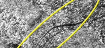
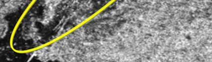
19 19

20 20


 vs.")
21 Colombia, Forested Area Digital Elevation Model P-band Magnitude Images P-band 9m tree Height X-band P-band Drainage feature profile comparison Top-Surface (X-band) vs. Sub-Surface (P-band) 21


22 Colombia, Revealing Terrain Under Forest Canopy Xvv - MAG Phh - MAG X-DEM P-DEM 22


23 Reveling Geologic Structure GeoSAR, Andes of Colombia 3D perspective of P-Band X radar MAG brightness on top of data P-Band overlaid IFSAR on X-band DEM IFSAR DEM 23


24 Colombia, Separating Forest from Terrain Comparison of X and P band DEM Foliage surfaces disappear in P-band DEM 24


25 Flooded wetlands below canopy X-band MAG P-band MAG 25

26 Drainage reconstruction X-DEM drainage, Strahler Orders 3-6 P-DEM drainage, Strahler Orders


27 Mapping drainage basins X-band Strahler Drainage Orders 4-6 P- band Strahler BasinOrders

28 Superimposing drainage over terrain models X Strahler Orders 3-6 P- Strahler Orders


29 Flood modelling from IFSAR DEMs X P Shaded relief 5m flood 10m flood 29
, Colombia,")
30 Standard X-band (3m), Colombia,

31 Identification of subtle drainage channels hidden by tall forest Inverted image X-band MAG 31

32 Identification of subtle drainage channels hidden by tall forest P-band MAG 32

33 Detecting structures below dense vegetation Comparing X and P Bands Airfield and other structures X-band image visible in P-band image 33

34 Detecting structures below dense vegetation Comparing X and P Bands 34


35 P-band3m 5mPosts Posts X-band Fence lines, trails, Power lines, and disturbed soils show up in the P-band 35


36 X- and P-band Radar Images, Papua New Guinea 1.25m X-band ORI Palm orchards and trails, irrigation patters, drainages exposed in P-band. Capable of counting trees in orchards 1.25m P-band ORI 36


37 Colombia, 2006 Adding Color Radar colorized though image processing of band combinations P, X, P 37
38 Colombia, Radar bands R = P, G = X, B = P-X 38


39 Turning Spatial Data Into Knowledge Thank you! Contact: Bill Sharp GeoSAR Regional Director Tel: (301) Cell: (240)
GeoSAR P-band and X-band Performance In Southern California and Colombia, South America
 GeoSAR P-band and X-band Performance In Southern California and Colombia, South America ISPRS International WG 1/2 Workshop 2005 James J Reis, EarthData Technologies Dr. Scott Hensley, Jet Propulsion Laboratory
EarthData International
 (Part 3) EarthData International >> By Marc S. Cheves, LS I recently met with Jeff Leonard, President and General Manager of EarthData International in Frederick, Maryland, and Tom Harrington, President
NEXTMAP. P-Band. Airborne Radar Imaging Technology. Key Benefits & Features INTERMAP.COM. Answers Now
 INTERMAP.COM Answers Now NEXTMAP P-Band Airborne Radar Imaging Technology Intermap is proud to announce the latest advancement of their Synthetic Aperture Radar (SAR) imaging technology. Leveraging over
RADAR (RAdio Detection And Ranging)
") RADAR (RAdio Detection And Ranging) CLASSIFICATION OF NONPHOTOGRAPHIC REMOTE SENSORS PASSIVE ACTIVE DIGITAL CAMERA THERMAL (e.g. TIMS) VIDEO CAMERA MULTI- SPECTRAL SCANNERS VISIBLE & NIR MICROWAVE Real
RADAR (RAdio Detection And Ranging) CLASSIFICATION OF NONPHOTOGRAPHIC REMOTE SENSORS PASSIVE ACTIVE DIGITAL CAMERA THERMAL (e.g. TIMS) VIDEO CAMERA MULTI- SPECTRAL SCANNERS VISIBLE & NIR MICROWAVE Real
SAR Imagery: Airborne or Spaceborne? Presenter: M. Lorraine Tighe PhD
 SAR Imagery: Airborne or Spaceborne? Presenter: M. Lorraine Tighe PhD Introduction The geospatial community has seen a plethora of spaceborne SAR imagery systems where there are now extensive archives
Introduction Active microwave Radar
 RADAR Imaging Introduction 2 Introduction Active microwave Radar Passive remote sensing systems record electromagnetic energy that was reflected or emitted from the surface of the Earth. There are also
THREE-DIMENSIONAL MAPPING USING BOTH AIRBORNE AND SPACEBORNE IFSAR TECHNOLOGIES ABSTRACT INTRODUCTION
 THREE-DIMENSIONAL MAPPING USING BOTH AIRBORNE AND SPACEBORNE IFSAR TECHNOLOGIES Trina Kuuskivi Manager of Value Added Products and Services, Intermap Technologies Corp. 2 Gurdwara Rd, Suite 200, Ottawa,
Introduction to Radar
 National Aeronautics and Space Administration ARSET Applied Remote Sensing Training http://arset.gsfc.nasa.gov @NASAARSET Introduction to Radar Jul. 16, 2016 www.nasa.gov Objective The objective of this
Active and Passive Microwave Remote Sensing
 Active and Passive Microwave Remote Sensing Passive remote sensing system record EMR that was reflected (e.g., blue, green, red, and near IR) or emitted (e.g., thermal IR) from the surface of the Earth.
Active and Passive Microwave Remote Sensing
 Active and Passive Microwave Remote Sensing Passive remote sensing system record EMR that was reflected (e.g., blue, green, red, and near IR) or emitted (e.g., thermal IR) from the surface of the Earth.
Introduction to RADAR Remote Sensing for Vegetation Mapping and Monitoring. Wayne Walker, Ph.D.
 Introduction to RADAR Remote Sensing for Vegetation Mapping and Monitoring Wayne Walker, Ph.D. Outline What is RADAR (and what does it measure)? RADAR as an active sensor Applications of RADAR to vegetation
Microwave Remote Sensing (1)
") Microwave Remote Sensing (1) Microwave sensing encompasses both active and passive forms of remote sensing. The microwave portion of the spectrum covers the range from approximately 1cm to 1m in wavelength.
Microwave Remote Sensing (1) Microwave sensing encompasses both active and passive forms of remote sensing. The microwave portion of the spectrum covers the range from approximately 1cm to 1m in wavelength.
THE NASA/JPL AIRBORNE SYNTHETIC APERTURE RADAR SYSTEM. Yunling Lou, Yunjin Kim, and Jakob van Zyl
 THE NASA/JPL AIRBORNE SYNTHETIC APERTURE RADAR SYSTEM Yunling Lou, Yunjin Kim, and Jakob van Zyl Jet Propulsion Laboratory California Institute of Technology 4800 Oak Grove Drive, MS 300-243 Pasadena,
10 Radar Imaging Radar Imaging
 10 Radar Imaging Active sensors provide their own source of energy to illuminate the target. Active sensors are generally divided into two distinct categories: imaging and non-imaging. The most common
Review. Guoqing Sun Department of Geography, University of Maryland ABrief
 Review Guoqing Sun Department of Geography, University of Maryland gsun@glue.umd.edu ABrief Introduction Scattering Mechanisms and Radar Image Characteristics Data Availability Example of Applications
Remote Sensing. Ch. 3 Microwaves (Part 1 of 2)
") Remote Sensing Ch. 3 Microwaves (Part 1 of 2) 3.1 Introduction 3.2 Radar Basics 3.3 Viewing Geometry and Spatial Resolution 3.4 Radar Image Distortions 3.1 Introduction Microwave (1cm to 1m in wavelength)
Remote Sensing Ch. 3 Microwaves (Part 1 of 2) 3.1 Introduction 3.2 Radar Basics 3.3 Viewing Geometry and Spatial Resolution 3.4 Radar Image Distortions 3.1 Introduction Microwave (1cm to 1m in wavelength)
Leica - 3 rd Generation Airborne Digital Sensors Features / Benefits for Remote Sensing & Environmental Applications
 Leica - 3 rd Generation Airborne Digital Sensors Features / Benefits for Remote Sensing & Environmental Applications Arthur Rohrbach, Sensor Sales Dir Europe, Middle-East and Africa (EMEA) Luzern, Switzerland,
GEO 428: DEMs from GPS, Imagery, & Lidar Tuesday, September 11
 GEO 428: DEMs from GPS, Imagery, & Lidar Tuesday, September 11 Global Positioning Systems GPS is a technology that provides Location coordinates Elevation For any location with a decent view of the sky
ACTIVE SENSORS RADAR
 ACTIVE SENSORS RADAR RADAR LiDAR: Light Detection And Ranging RADAR: RAdio Detection And Ranging SONAR: SOund Navigation And Ranging Used to image the ocean floor (produce bathymetic maps) and detect objects
Outline. Introduction. Introduction: Film Emulsions. Sensor Systems. Types of Remote Sensing. A/Prof Linlin Ge. Photographic systems (cf(
 GMAT x600 Remote Sensing / Earth Observation Types of Sensor Systems (1) Outline Image Sensor Systems (i) Line Scanning Sensor Systems (passive) (ii) Array Sensor Systems (passive) (iii) Antenna Radar
Helicopter Aerial Laser Ranging
 Helicopter Aerial Laser Ranging Håkan Sterner TopEye AB P.O.Box 1017, SE-551 11 Jönköping, Sweden 1 Introduction Measuring distances with light has been used for terrestrial surveys since the fifties.
Ghazanfar A. Khattak National Centre of Excellence in Geology University of Peshawar
 INTRODUCTION TO REMOTE SENSING Ghazanfar A. Khattak National Centre of Excellence in Geology University of Peshawar WHAT IS REMOTE SENSING? Remote sensing is the science of acquiring information about
Windstorm Simulation & Modeling Project
 Windstorm Simulation & Modeling Project Manatee County Digital Elevation Models Preliminary Report Prepared for: The Manatee County Public Safety Department 1112 Manatee Avenue West, Suite 525 Bradenton,
Passive Microwave Sensors LIDAR Remote Sensing Laser Altimetry. 28 April 2003
 Passive Microwave Sensors LIDAR Remote Sensing Laser Altimetry 28 April 2003 Outline Passive Microwave Radiometry Rayleigh-Jeans approximation Brightness temperature Emissivity and dielectric constant
MAPPING DAMAGES CAUSED BY THE OCTOBER 2003 WILDFIRES IN CALIFORNIA
 MAPPING DAMAGES CAUSED BY THE OCTOBER 2003 WILDFIRES IN CALIFORNIA Louis Demargne & Mitch Jordan EarthData International 7320 Executive Way, Frederick, MD 21702 ABSTRACT EarthData, in coordination with
RADAR REMOTE SENSING
 RADAR REMOTE SENSING Jan G.P.W. Clevers & Steven M. de Jong Chapter 8 of L&K 1 Wave theory for the EMS: Section 1.2 of L&K E = electrical field M = magnetic field c = speed of light : propagation direction
CEGEG046 / GEOG3051 Principles & Practice of Remote Sensing (PPRS) 8: RADAR 1
 8: RADAR 1") CEGEG046 / GEOG3051 Principles & Practice of Remote Sensing (PPRS) 8: RADAR 1 Dr. Mathias (Mat) Disney UCL Geography Office: 113, Pearson Building Tel: 7670 05921 Email: mdisney@ucl.geog.ac.uk www.geog.ucl.ac.uk/~mdisney
CEGEG046 / GEOG3051 Principles & Practice of Remote Sensing (PPRS) 8: RADAR 1 Dr. Mathias (Mat) Disney UCL Geography Office: 113, Pearson Building Tel: 7670 05921 Email: mdisney@ucl.geog.ac.uk www.geog.ucl.ac.uk/~mdisney
APPLICATIONS AND LESSONS LEARNED WITH AIRBORNE MULTISPECTRAL IMAGING
 APPLICATIONS AND LESSONS LEARNED WITH AIRBORNE MULTISPECTRAL IMAGING James M. Ellis and Hugh S. Dodd The MapFactory and HJW Walnut Creek and Oakland, California, U.S.A. ABSTRACT Airborne digital frame
SAR Othorectification and Mosaicking
 White Paper SAR Othorectification and Mosaicking John Wessels: Senior Scientist PCI Geomatics SAR Othorectification and Mosaicking This study describes the high-speed orthorectification and mosaicking
School of Rural and Surveying Engineering National Technical University of Athens
 Laboratory of Photogrammetry National Technical University of Athens Combined use of spaceborne optical and SAR data Incompatible data sources or a useful procedure? Charalabos Ioannidis, Dimitra Vassilaki
An Introduction to Geomatics. Prepared by: Dr. Maher A. El-Hallaq خاص بطلبة مساق مقدمة في علم. Associate Professor of Surveying IUG
 An Introduction to Geomatics خاص بطلبة مساق مقدمة في علم الجيوماتكس Prepared by: Dr. Maher A. El-Hallaq Associate Professor of Surveying IUG 1 Airborne Imagery Dr. Maher A. El-Hallaq Associate Professor
Aerial Photo Interpretation
 Aerial Photo Interpretation Aerial Photo Interpretation To date, course has focused on skills of photogrammetry Scale Distance Direction Area Height There s another side to Aerial Photography: Interpretation
Baldwin and Mobile Counties, AL Orthoimagery Project Report. Submitted: March 23, 2016
 2015 Orthoimagery Project Report Submitted: Prepared by: Quantum Spatial, Inc 523 Wellington Way, Suite 375 Lexington, KY 40503 859-277-8700 Page i of iii Contents Project Report 1. Summary / Scope...
COMPARISON OF DEMS FROM STAR-3i INTERFEROMETRIC SAR AND SCANNING LASER
 COMPARISON OF DEMS FROM STAR-3i INTERFEROMETRIC SAR AND SCANNING LASER J. Bryan Mercer and Steven Schnick Intermap Technologies Corp. Calgary, Alberta, Canada Tel: (403) 266-0900 Fax: (403) 265-0499 e-mail:
Module 3 Introduction to GIS. Lecture 8 GIS data acquisition
 Module 3 Introduction to GIS Lecture 8 GIS data acquisition GIS workflow Data acquisition (geospatial data input) GPS Remote sensing (satellites, UAV s) LiDAR Digitized maps Attribute Data Management Data
MSB Imagery Program FAQ v1
 MSB Imagery Program FAQ v1 (F)requently (A)sked (Q)uestions 9/22/2016 This document is intended to answer commonly asked questions related to the MSB Recurring Aerial Imagery Program. Table of Contents
HIGH RESOLUTION COLOR IMAGERY FOR ORTHOMAPS AND REMOTE SENSING. Author: Peter Fricker Director Product Management Image Sensors
 HIGH RESOLUTION COLOR IMAGERY FOR ORTHOMAPS AND REMOTE SENSING Author: Peter Fricker Director Product Management Image Sensors Co-Author: Tauno Saks Product Manager Airborne Data Acquisition Leica Geosystems
NON-PHOTOGRAPHIC SYSTEMS: Multispectral Scanners Medium and coarse resolution sensor comparisons: Landsat, SPOT, AVHRR and MODIS
 NON-PHOTOGRAPHIC SYSTEMS: Multispectral Scanners Medium and coarse resolution sensor comparisons: Landsat, SPOT, AVHRR and MODIS CLASSIFICATION OF NONPHOTOGRAPHIC REMOTE SENSORS PASSIVE ACTIVE DIGITAL
The SARTOM Project; Tomography for enhanced target detection for foliage penetrating airborne SAR (First-Year Results)
") The SARTOM Project; Tomography for enhanced target detection for foliage penetrating airborne SAR (First-Year Results) Ralf Horn 1, Jens Fischer 1, Armando Marino 2, Matteo Nannini 1, Kim Partington 3,
The SARTOM Project; Tomography for enhanced target detection for foliage penetrating airborne SAR (First-Year Results) Ralf Horn 1, Jens Fischer 1, Armando Marino 2, Matteo Nannini 1, Kim Partington 3,
Processing of stereo scanner: from stereo plotter to pixel factory
 Photogrammetric Week '03 Dieter Fritsch (Ed.) Wichmann Verlag, Heidelberg, 2003 Bignone 141 Processing of stereo scanner: from stereo plotter to pixel factory FRANK BIGNONE, ISTAR, France ABSTRACT With
Principles of Remote Sensing. Shuttle Radar Topography Mission S R T M. Michiel Damen. Dept. Earth Systems Analysis
 Principles of Remote Sensing Shuttle Radar Topography Mission S R T M Michiel Damen Dept. Earth Systems Analysis Contents Present problems with DEMs Advantage of SRTM Cell size Mission and system Radar
ANALYSIS OF SRTM HEIGHT MODELS
 ANALYSIS OF SRTM HEIGHT MODELS Sefercik, U. *, Jacobsen, K.** * Karaelmas University, Zonguldak, Turkey, ugsefercik@hotmail.com **Institute of Photogrammetry and GeoInformation, University of Hannover,
Synthetic aperture RADAR (SAR) principles/instruments October 31, 2018
 principles/instruments October 31, 2018") GEOL 1460/2461 Ramsey Introduction to Remote Sensing Fall, 2018 Synthetic aperture RADAR (SAR) principles/instruments October 31, 2018 I. Reminder: Upcoming Dates lab #2 reports due by the start of next
GEOL 1460/2461 Ramsey Introduction to Remote Sensing Fall, 2018 Synthetic aperture RADAR (SAR) principles/instruments October 31, 2018 I. Reminder: Upcoming Dates lab #2 reports due by the start of next
746A27 Remote Sensing and GIS. Multi spectral, thermal and hyper spectral sensing and usage
 746A27 Remote Sensing and GIS Lecture 3 Multi spectral, thermal and hyper spectral sensing and usage Chandan Roy Guest Lecturer Department of Computer and Information Science Linköping University Multi
The Normal Baseline. Dick Gent Law of the Sea Division UK Hydrographic Office
 The Normal Baseline Dick Gent Law of the Sea Division UK Hydrographic Office 2 The normal baseline for measuring the breadth of the territorial sea is the low water line along the coast as marked on large
Aerial photography and Remote Sensing. Bikini Atoll, 2013 (60 years after nuclear bomb testing)
") Aerial photography and Remote Sensing Bikini Atoll, 2013 (60 years after nuclear bomb testing) Computers have linked mapping techniques under the umbrella term : Geomatics includes all the following spatial
Aerial photography and Remote Sensing Bikini Atoll, 2013 (60 years after nuclear bomb testing) Computers have linked mapping techniques under the umbrella term : Geomatics includes all the following spatial
CryoVEx08/09 Antarctica
 CryoVEx08/09 Antarctica Final presentation Veit Helm, AWI 2009-11-13 CryoVEx08/09 ANT FM, ESTEC 1/27 Overview Campaign overview Processing status Calibration Datation Data analysis Summary 2009-11-13 CryoVEx08/09
Status of MOLI development MOLI (Multi-footprint Observation Lidar and Imager)
") Status of MOLI development MOLI (Multi-footprint Observation Lidar and Imager) Tadashi IMAI, Daisuke SAKAIZAWA, Jumpei MUROOKA and Toshiyoshi KIMURA JAXA 1 Outline of This Presentation 1. Overview of MOLI
Status of MOLI development MOLI (Multi-footprint Observation Lidar and Imager) Tadashi IMAI, Daisuke SAKAIZAWA, Jumpei MUROOKA and Toshiyoshi KIMURA JAXA 1 Outline of This Presentation 1. Overview of MOLI
The studies began when the Tiros satellites (1960) provided man s first synoptic view of the Earth s weather systems.
 provided man s first synoptic view of the Earth s weather systems.") Remote sensing of the Earth from orbital altitudes was recognized in the mid-1960 s as a potential technique for obtaining information important for the effective use and conservation of natural resources.
Remote sensing of the Earth from orbital altitudes was recognized in the mid-1960 s as a potential technique for obtaining information important for the effective use and conservation of natural resources.
LECTURE NOTES 2016 CONTENTS. Sensors and Platforms for Acquisition of Aerial and Satellite Image Data
 LECTURE NOTES 2016 Prof. John TRINDER School of Civil and Environmental Engineering Telephone: (02) 9 385 5020 Fax: (02) 9 313 7493 j.trinder@unsw.edu.au CONTENTS Chapter 1 Chapter 2 Sensors and Platforms
E m e r g e n c y M a n a g e m e n t S e r v i c e. C o p e r n i c u s A e r i a l c o m p o n e n t s t a t u s s t u d y
 E m e r g e n c y M a n a g e m e n t S e r v i c e C o p e r n i c u s A e r i a l c o m p o n e n t s t a t u s s t u d y Peter Spruyt European Commission Joint Research Centre EMS Mapping User Workshop
Differential Global Positioning ~ System Techniques For Surveying/ Mapping within Forested Wetlands
 WRP Technical Note WG-SW-2.2 ~- Differential Global Positioning ~ System Techniques For Surveying/ Mapping within Forested Wetlands PURPOSE: This technical note describes the use of Differential Global
EARLY DEVELOPMENT IN SYNTHETIC APERTURE LIDAR SENSING FOR ON-DEMAND HIGH RESOLUTION IMAGING
 EARLY DEVELOPMENT IN SYNTHETIC APERTURE LIDAR SENSING FOR ON-DEMAND HIGH RESOLUTION IMAGING ICSO 2012 Ajaccio, Corse, France, October 11th, 2012 Alain Bergeron, Simon Turbide, Marc Terroux, Bernd Harnisch*,
Exploring the Potential Pol-InSAR Techniques at X-Band: First Results & Experiments from TanDEM-X
 Exploring the Potential Pol-InSAR Techniques at X-Band: First Results & Experiments from TanDEM-X K. Papathanassiou, F. Kugler, J-S. Kim, S-K. Lee, I. Hajnsek Microwaves and Radar Institute (DLR-HR) German
MODULE 7 LECTURE NOTES 3 SHUTTLE RADAR TOPOGRAPHIC MISSION DATA
 MODULE 7 LECTURE NOTES 3 SHUTTLE RADAR TOPOGRAPHIC MISSION DATA 1. Introduction Availability of a reasonably accurate elevation information for many parts of the world was once very much limited. Dense
Leica ADS80 - Digital Airborne Imaging Solution NAIP, Salt Lake City 4 December 2008
 Luzern, Switzerland, acquired at 5 cm GSD, 2008. Leica ADS80 - Digital Airborne Imaging Solution NAIP, Salt Lake City 4 December 2008 Shawn Slade, Doug Flint and Ruedi Wagner Leica Geosystems AG, Airborne
INNOVATIVE SPECTRAL IMAGING
 INNOVATIVE SPECTRAL IMAGING food inspection precision agriculture remote sensing defense & reconnaissance advanced machine vision product overview INNOVATIVE SPECTRAL IMAGING Innovative diffractive optics
Accuracy assessment of a digital height model derived from airborne synthetic aperture radar measurements
 Kleusberg, Klaedtke 139 Accuracy assessment of a digital height model derived from airborne synthetic aperture radar measurements ALFRED KLEUS BERG and HANS-GEORG KLAEDTKE, S tuttgart ABSTRACT A digital
Sources of Geographic Information
 Sources of Geographic Information Data properties: Spatial data, i.e. data that are associated with geographic locations Data format: digital (analog data for traditional paper maps) Data Inputs: sampled
Description of the Instruments and Algorithm Approach
 Description of the Instruments and Algorithm Approach Passive and Active Remote Sensing SMAP uses active and passive sensors to measure soil moisture National Aeronautics and Space Administration Applied
Fugro commence new Airborne Lidar Bathymetry trials
 Fugro commence new Airborne Lidar Bathymetry trials Laurent Pronier 20 May 2011 Marrakech, Morocco, 18-22 May 2011 Contents Menu LADS Technology - History LADS Mk I (RAN LADS I) LADS Mk II RAN LADS II
DEMS BASED ON SPACE IMAGES VERSUS SRTM HEIGHT MODELS. Karsten Jacobsen. University of Hannover, Germany
 DEMS BASED ON SPACE IMAGES VERSUS SRTM HEIGHT MODELS Karsten Jacobsen University of Hannover, Germany jacobsen@ipi.uni-hannover.de Key words: DEM, space images, SRTM InSAR, quality assessment ABSTRACT
ASSESSMENT OF SRTM, ACE2 AND ASTER-GDEM USING RTK-GPS
 ASSESSMENT OF SRTM, ACE2 AND ASTER-GDEM USING RTK-GPS Hsing-Chung Chang, Xiaojing Li, Linlin Ge School of Surveying and Spatial Information Systems The University of New South Wales, Sydney, NSW 2052,
DEMs Created from Airborne IFSAR An Update
 DEMs Created from Airborne IFSAR An Update Bryan Mercer Intermap Technologies Corp., 1000, 736 8 th Ave. S.W., Calgary, AB, Canada, T2P 1H4 bmercer@intermap.ca Commission II, WGII/2 KEYWORDS: Interferometric
REMOTE SENSING. Topic 10 Fundamentals of Digital Multispectral Remote Sensing MULTISPECTRAL SCANNERS MULTISPECTRAL SCANNERS
 REMOTE SENSING Topic 10 Fundamentals of Digital Multispectral Remote Sensing Chapter 5: Lillesand and Keifer Chapter 6: Avery and Berlin MULTISPECTRAL SCANNERS Record EMR in a number of discrete portions
9/13/2011. Training Course Remote Sensing Basic Theory & Image Processing Methods September 2011
 Training Course Remote Sensing Basic Theory & Image Processing Methods 19 23 September 2011 DIGITAL TERRAIN MODELS Introduction Michiel Damen (April 2011) damen@itc.nl 1 Digital Elevation and Terrain Models
EnsoMOSAIC Aerial mapping tools
 EnsoMOSAIC Aerial mapping tools Jakarta and Kuala Lumpur, 2013 Contents MosaicMill MM Application examples Software introduction System introduction Rikola HS sensor UAV platform examples SW Syst HS UAV
UAV-based remote sensing of the slow-moving landslide Super-Sauze
 Universität Stuttgart UAV-based remote sensing of the slow-moving landslide Super-Sauze U. Niethammer, S. Rothmund, M. Joswig 06.02.2009 Motivation The four main objectives for our remote sensing campaign
IGI Ltd. Serving the Aerial Survey Industry for more than 20 Years
 'Photogrammetric Week 05' Dieter Fritsch, Ed. Wichmann Verlag, Heidelberg 2005. Kremer 33 IGI Ltd. Serving the Aerial Survey Industry for more than 20 Years JENS KREMER, Kreuztal ABSTRACT Since 1982 IGI
RIEGL VQ -780i NEW. Airborne Laser Scanning. Waveform Processing Airborne Laser Scanner for Ultra Wide Area Mapping and High Productivity.
 Waveform Processing Airborne Laser Scanner for Ultra Wide Area Mapping and High Productivity. NEW RIEGL VQ -78i online waveform processing as well as smart and full waveform recording excellent multiple
SAR Multi-Temporal Applications
 SAR Multi-Temporal Applications 83230359-DOC-TAS-EN-001 Contents 2 Advantages of SAR Remote Sensing Technology All weather any time Frequencies and polarisations Interferometry and 3D mapping Change Detection
USE OF IMPROVISED REMOTELY SENSED DATA FROM UAV FOR GIS AND MAPPING, A CASE STUDY OF GOMA CITY, DR CONGO
 USE OF IMPROVISED REMOTELY SENSED DATA FROM UAV FOR GIS AND MAPPING, A CASE STUDY OF GOMA CITY, DR CONGO Cung Chin Thang United Nations Global Support Center, Brindisi, Italy, Email: thang@un.org KEY WORDS:
Imaging radar Imaging radars provide map-like coverage to one or both sides of the aircraft.
 CEE 6100 / CSS 6600 Remote Sensing Fundamentals 1 Imaging radar Imaging radars provide map-like coverage to one or both sides of the aircraft. Acronyms: RAR real aperture radar ("brute force", "incoherent")
NEW. Airborne Laser Scanning. Waveform Processing Airborne Laser Scanner for Wide Area Mapping and High Productivity. visit our website
 Waveform Processing Airborne Laser Scanner for Wide Area Mapping and High Productivity. NEW RIEGL VQ -780i online waveform processing as well as smart and full waveform recording excellent multiple target
Detection of traffic congestion in airborne SAR imagery
 Detection of traffic congestion in airborne SAR imagery Gintautas Palubinskas and Hartmut Runge German Aerospace Center DLR Remote Sensing Technology Institute Oberpfaffenhofen, 82234 Wessling, Germany
Profiling Radiometer for Atmospheric and Cloud Observations PRACO
 Profiling Radiometer for Atmospheric and Cloud Observations PRACO Boulder Environmental Sciences and Technology BEST Small startup company, established in 2006 Focused on radiometry ground based and airborne
TESTFIELD TRENTO: GEOMETRIC EVALUATION OF VERY HIGH RESOLUTION SATELLITE IMAGERY
 TESTFIELD TRENTO: GEOMETRIC EVALUATION OF VERY HIGH RESOLUTION SATELLITE IMAGERY G. AGUGIAROa, D. POLIb, F. REMONDINOa, 3DOM, 3D Optical Metrology Unit Bruno Kessler Foundation, Trento, Italy a b Vermessung
[GEOMETRIC CORRECTION, ORTHORECTIFICATION AND MOSAICKING]
![[GEOMETRIC CORRECTION, ORTHORECTIFICATION AND MOSAICKING]](/thumbs/78/78211997.jpg "[GEOMETRIC CORRECTION, ORTHORECTIFICATION AND MOSAICKING]") 2013 Ogis-geoInfo Inc. IBEABUCHI NKEMAKOLAM.J [GEOMETRIC CORRECTION, ORTHORECTIFICATION AND MOSAICKING] [Type the abstract of the document here. The abstract is typically a short summary of the contents
2013 Ogis-geoInfo Inc. IBEABUCHI NKEMAKOLAM.J [GEOMETRIC CORRECTION, ORTHORECTIFICATION AND MOSAICKING] [Type the abstract of the document here. The abstract is typically a short summary of the contents
Introduction to Remote Sensing Fundamentals of Satellite Remote Sensing. Mads Olander Rasmussen
 Introduction to Remote Sensing Fundamentals of Satellite Remote Sensing Mads Olander Rasmussen (mora@dhi-gras.com) 01. Introduction to Remote Sensing DHI What is remote sensing? the art, science, and technology
Govt. Engineering College Jhalawar Model Question Paper Subject- Remote Sensing & GIS
 Govt. Engineering College Jhalawar Model Question Paper Subject- Remote Sensing & GIS Time: Max. Marks: Q1. What is remote Sensing? Explain the basic components of a Remote Sensing system. Q2. What is
Technical Notes LAND MAPPING APPLICATIONS. Leading the way with increased reliability.
 LAND MAPPING APPLICATIONS Technical Notes Leading the way with increased reliability. Industry-leading post-processing software designed to maximize the accuracy potential of your POS LV (Position and
Orthoimagery Standards. Chatham County, Georgia. Jason Lee and Noel Perkins
 1 Orthoimagery Standards Chatham County, Georgia Jason Lee and Noel Perkins 2 Table of Contents Introduction... 1 Objective... 1.1 Data Description... 2 Spatial and Temporal Environments... 3 Spatial Extent
Black Dot shows actual Point location
 207 Plate 1 Use of scanned archive aerial photographs, digital photogrammetry and GIS to plot river channel erosion along the Afon Trannon, Wales (part of the study by Mount et al 2000, 2003). Plate 2
Basics of Photogrammetry Note#6
 Basics of Photogrammetry Note#6 Photogrammetry Art and science of making accurate measurements by means of aerial photography Analog: visual and manual analysis of aerial photographs in hard-copy format
Microwave Remote Sensing
 Provide copy on a CD of the UCAR multi-media tutorial to all in class. Assign Ch-7 and Ch-9 (for two weeks) as reading material for this class. HW#4 (Due in two weeks) Problems 1,2,3 and 4 (Chapter 7)
DETAILED CHANGE DETECTION USING HIGH SPATIAL RESOLUTION FRAME CENTER MATCHED AERIAL PHOTOGRAPHY INTRODUCTION
 DETAILED CHANGE DETECTION USING HIGH SPATIAL RESOLUTION FRAME CENTER MATCHED AERIAL PHOTOGRAPHY Lloyd L. Coulter, Steven J. Lathrop, and Douglas A. Stow Department of Geography San Diego State University
A CONCEPT FOR NATURAL GAS TRANSMISSION PIPELINE MONITORING BASED ON NEW HIGH-RESOLUTION REMOTE SENSING TECHNOLOGIES
 A CONCEPT FOR NATURAL GAS TRANSMISSION PIPELINE MONITORING BASED ON NEW HIGH-RESOLUTION REMOTE SENSING TECHNOLOGIES Werner Zirnig - Ruhrgas Aktiengesellschaft Dieter Hausamann - DLR German Aerospace Center
SAR Remote Sensing (Microwave Remote Sensing)
") iirs SAR Remote Sensing (Microwave Remote Sensing) Synthetic Aperture Radar Shashi Kumar shashi@iirs.gov.in Electromagnetic Radiation Electromagnetic radiation consists of an electrical field(e) which
iirs SAR Remote Sensing (Microwave Remote Sensing) Synthetic Aperture Radar Shashi Kumar shashi@iirs.gov.in Electromagnetic Radiation Electromagnetic radiation consists of an electrical field(e) which
Three-dimensional investigation of buried structures with multi-transducer parametric sub-bottom profiler as part of hydrographical applications
 Three-dimensional investigation of buried structures with multi-transducer parametric sub-bottom profiler as part Jens LOWAG, Germany, Dr. Jens WUNDERLICH, Germany, Peter HUEMBS, Germany Key words: parametric,
White Paper Reaching 1 cm (0.4 in) drone survey accuracy
 drone survey accuracy") White Paper Reaching 1 cm (0.4 in) drone survey accuracy 3x higher absolute accuracy with WingtraOne Latest tests in USA and Switzerland prove that the VTOL WingtraOne drone repeatably reaches the best-in-class
White Paper Reaching 1 cm (0.4 in) drone survey accuracy 3x higher absolute accuracy with WingtraOne Latest tests in USA and Switzerland prove that the VTOL WingtraOne drone repeatably reaches the best-in-class
Detection of Pipelines using Sub-Audio Magnetics (SAM)
") Gap Geophysics Australia Pty Ltd. Detection of Pipelines using Sub-Audio Magnetics is a patented technique developed by Gap Geophysics. The technique uses a fast sampling magnetometer to monitor magnetic
Gap Geophysics Australia Pty Ltd. Detection of Pipelines using Sub-Audio Magnetics is a patented technique developed by Gap Geophysics. The technique uses a fast sampling magnetometer to monitor magnetic
Radar Imagery for Forest Cover Mapping
 Purdue University Purdue e-pubs LARS Symposia Laboratory for Applications of Remote Sensing 1-1-1981 Radar magery for Forest Cover Mapping D. J. Knowlton R. M. Hoffer Follow this and additional works at:
White Paper Reaching 1 cm (0.4 in) drone survey accuracy
 drone survey accuracy") White Paper Reaching 1 cm (0.4 in) drone survey accuracy 3x higher absolute accuracy with WingtraOne Latest tests in USA and Switzerland prove that the VTOL WingtraOne drone repeatably reaches the best-in-class
White Paper Reaching 1 cm (0.4 in) drone survey accuracy 3x higher absolute accuracy with WingtraOne Latest tests in USA and Switzerland prove that the VTOL WingtraOne drone repeatably reaches the best-in-class
Lecture Notes Prepared by Prof. J. Francis Spring Remote Sensing Instruments
 Lecture Notes Prepared by Prof. J. Francis Spring 2005 Remote Sensing Instruments Material from Remote Sensing Instrumentation in Weather Satellites: Systems, Data, and Environmental Applications by Rao,
Fusion of Heterogeneous Multisensor Data
 Fusion of Heterogeneous Multisensor Data Karsten Schulz, Antje Thiele, Ulrich Thoennessen and Erich Cadario Research Institute for Optronics and Pattern Recognition Gutleuthausstrasse 1 D 76275 Ettlingen
Geo-localization and Mosaicing System (GEMS): Enabling Precision Image Feature Location and Rapid Mosaicing General:
: Enabling Precision Image Feature Location and Rapid Mosaicing General:") Geo-localization and Mosaicing System (GEMS): Enabling Precision Image Feature Location and Rapid Mosaicing General: info@senteksystems.com www.senteksystems.com 12/6/2014 Precision Agriculture Multi-Spectral
Geo-localization and Mosaicing System (GEMS): Enabling Precision Image Feature Location and Rapid Mosaicing General: info@senteksystems.com www.senteksystems.com 12/6/2014 Precision Agriculture Multi-Spectral
Aerial Image Acquisition and Processing Services. Ron Coutts, M.Sc., P.Eng. RemTech, October 15, 2014
 Aerial Image Acquisition and Processing Services Ron Coutts, M.Sc., P.Eng. RemTech, October 15, 2014 Outline Applications & Benefits Image Sources Aircraft Platforms Image Products Sample Images & Comparisons
High Resolution Multi-spectral Imagery
 High Resolution Multi-spectral Imagery Jim Baily, AirAgronomics AIRAGRONOMICS Having been involved in broadacre agriculture until 2000 I perceived a need for a high resolution remote sensing service to
Soil moisture retrieval using ALOS PALSAR
 Soil moisture retrieval using ALOS PALSAR T. J. Jackson, R. Bindlish and M. Cosh USDA ARS Hydrology and Remote Sensing Lab, Beltsville, MD J. Shi University of California Santa Barbara, CA November 6,
Photomod Lite Contest 2013 Creating vegetation map using UAV at Seaside Palouki forest (Greece) by Apostolos Nteris
 by Apostolos Nteris") P r o j e c t I n f o r m a t i o n Title: Creating vegetation map using UAV at seaside Palouki forest (Greece) Author: Apostolos Nteris, Surveyor engineer OLYZON consulting - Trikala Greece Contact: Apostolos
P r o j e c t I n f o r m a t i o n Title: Creating vegetation map using UAV at seaside Palouki forest (Greece) Author: Apostolos Nteris, Surveyor engineer OLYZON consulting - Trikala Greece Contact: Apostolos