«INTRARADAR» Port of Corfu
|
|
|
- Ashlee Phelps
- 5 years ago
- Views:
Transcription
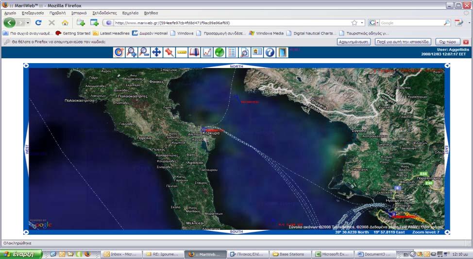
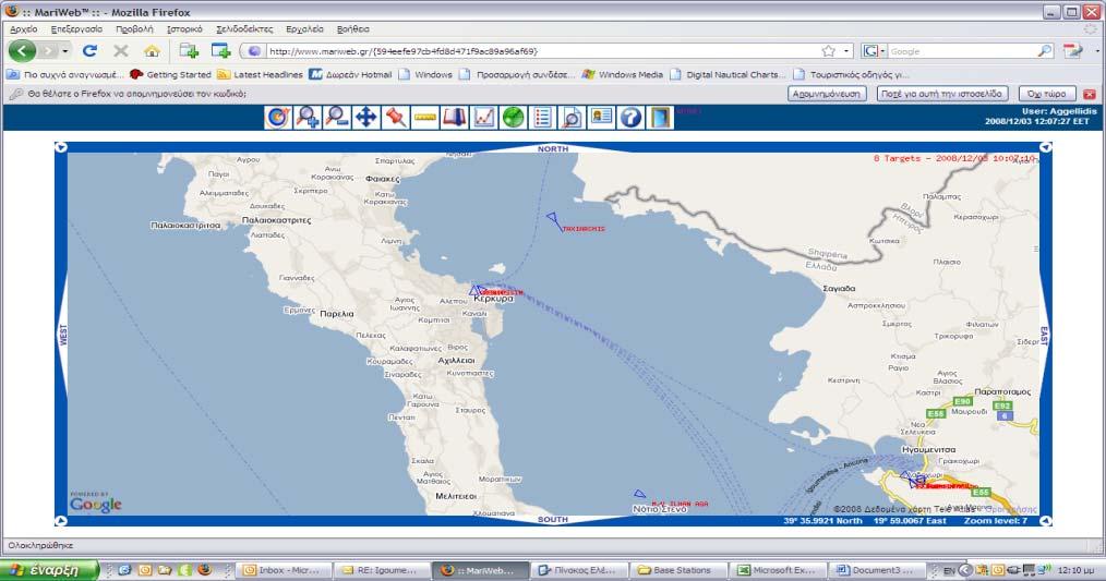
1 «INTRARADAR» Port of Corfu INTERREG IIIA Greece-Italy IMPETUS was the contractor of the Prefecture of Corfu for the INTRARADAR project. The project focused on the provision, installation of hardware/software in the Port of Corfu. In addition, Dr. Nick A. Theofilopoulos, the Director of Research and Development of IMPETUS, was the Coordinator (Project Manager) of the project. Impetus implemented a system of management of the target of the ships in the wider region around the port of Corfu. Through the implementation of this system it was achieved the control, the safety and the precise briefing of local Authorities with regard to the movement of the passengers and commercial ships, as well as recreation ships in the region. The need for a continuous and more detailed control in the coastal movement of ships, in order to prevent accidents in the sea and accidents inside the port area, it is developing in the last years through the improvement and extension of complicated systems with big requirements, which involve the ports installations. INTRA RADAR was a project which dealt with the Transport, the Communication and the Safety and it forecasted the implementation of infrastructures projects of information systems for the aid of cross-border relations and the safe circulation of goods and individuals, the completion of infrastructure interventions, while improving the offered services, the growth of structures and of the qualitative services for circulation of people and goods, improving also the growth of modern information and communications technologies for the management of services that concern the transport of goods and individuals. The advantages that resulted from the project s implementation, with the offer of such services, are enormous for the European Citizen, the competitiveness of the ports of the Western Region of Greece are also increased. The demand from politicians and maritime authorities, to have control over movements of ships in their territorial waters, in order to prevent accidents and marine disasters, is growing increasingly stronger. Coastal states are responsible for traffic separation schemes, routing areas and fish catch areas in their territorial waters. These states demand compulsory compliance by those, who use these waters and have a need to monitor "areas to be avoided". Just the fact, that the user is monitored and identified from shore, will most probably result in a greater compliance with traffic separation schemes, routing measures and fishing regulations. It has been argued, that accidents in coastal areas could be avoided, if the ship is identified. This maybe true in some cases, but a shore station, that identified a ship, is limited to advise actions only over VHF. Furthermore, this advice may be misunder-stood because of language problems. In very busy areas, like harbours, rivers and archipelagos, the need for a high update rate beacon mode AIS is evident. The limitations of the ARPA radar to track ships due to target swapping from a ship to land, beacons, bridges and other ships makes the ARPA capabilities very limited in narrow and congested waters.

2 Today there is a strong feeling among mariners navigating in harbours, rivers and archipelagos, that an broadcast AIS would improve the safety and solve the limitations of the radar because of the following capabilities. A broadcast AIS is able to: look behind the bend in a channel or behind an island in an archipelago, to detect the presence of other ships and identify them. predict the exact position of a meeting with other ships in a river or in the archipelago to avoid meeting in e.g. a narrow river bend. know which port and which harbour a ship is bound for know the size and the draft of ships in the vicinity. detect a change in a ship s heading almost in real time identify a ferry leaving the shore bank in a river. An AIS, using broadcast techniques and with a high update rate, enhances the possibility of detecting the whereabouts of other ships, even if they are behind a bend in a canal or river or behind an island in an archipelago. The AIS also solves the inherent problem with all radars, by detecting fishing boats and smaller ships, fitted with AIS, in sea-clutter and in heavy rain. Innovative technologies like ship-to-ship and ship-to-shore AIS have a big potential in improving safety in the maritime field in the future. It also makes it possible to identify, track and supervise ships from shore with a much higher and more sustainable accuracy than with a shore based radar. On the other hand, the need for navigational assistance from shore on a ship, with ship to ship and ship-to-shore AIS onboard, is surely less, than on a ship only fitted with a radar, when both are affected by sea/rain clutter. IMPETUS provided an integrated and comprehensive solution for the INTRARADAR project and an experience that was gained from the implementation of other major projects. These made Impetus offer a credible and responsible solution that combined state of the art- technologies and solutions. The system that was delivered by IMPETUS, as a turn key solution has the possibility of observing and management: Targets Ais-Automatic Identification System (main system) Targets RADAR (main system) Targets via cameras (auxiliary system) The all system, however, is articulated in three parts: hardware: the radar system and all electronic data a fast wide area connection that supports the interconnection between radar and the centre of operation software, that directs the system, connected, simultaneously, with preexisting structures but also the proposed and future ones The set-up of the system is such that in the case of damage of the AIS monitoring system it can continue the monitoring of RADAR targets and reverse. The architecture of the system, additionally, allows the remote management of the network and its applications. The aforementioned operations and the characteristics are conditioned by the international case law and regulations (IMO, IALA, ITU etc).

3 At the Port it has been installed an independent system in specifically shaped space which functions for the monitoring and management of targets in the region of interest. Each system is constituted by two independent work stations through which the user can monitor and manage the ships via AIS, Radar and cameras, which are placed in the roof of the Port s Authority building. Each system is constituted by a System Server which receives the data from the aforementioned sensors and provides the possibility to the user of: 1.Observing AIS and RADAR targets in electronic map 2.Geting information regarding the ships details: place, speed, course, EDF, MMSI, size, flag etc. 3.Displaying the ships per category (ships, lorries, dangerous charges k.a.) 4.Managing the database of given ships 5.Search of targets by name, MMSI, type (commercial, tanker, passenger ktl.) 6.Procreation of the ships historical data up to one year retrospectively. 7.Determination of incidents, alarms and notices (eg automatic notice for the entry of passenger ships in predetermined by the user area). The Project INTRARADAR is a system of telematics that aims at enabling the monitor and management of targets Ais-Automatic Identification System (main system), targets RADAR (main system) and targets via cameras (auxiliary system). Each union of the aforementioned network it is being realised with the use of protocol TCP/IP even if the distances are small. This provision also allows the remote network management and its applications. We offered a "turn key solution", namely a system that has three sensors for the monitor and the management of ships. The sensors are an AIS basestation, a RADAR system and an IP Camera. There can be connected in this system in total 6 users. The three users work from the work stations that have been installed in the Port and the other three users work through a remote connection. All the users and the sensors are connected with the (CDS) system server with which, they have a bidirectional communication. AIS Base Station AIS Base Station receives all the data from all the AIS appliances that are installed in the ships that approach the in VHF region, emitting automatically the relative data in the computers via the AIS Server. Besides it allows the reception and depiction of data from all the stations to the computers that are installed in the same network. The use of information is possible to be graded in order for the AIS administrator to allow concrete users to manage these. The AIS Base Station is constituted by: VHF transceiver GPS Receiver control Unit IP controller GPS Aerial and VHF aerial Radar System The system has the possibility of receiving via the Scanner, the GPS aerial and the compass, all the information concerning the boats and ships of the region and dispatching them via TCP/IP in the system server in the form of HARP.

 that support the operation of RADAR, Server and Base Station and 3 Workstations.")
 interface, using SQL language (Structured Query Language), allowing thus complete access in all")
 uses PHP (Hypertext Preprocessor).")
4 The RADAR System is constituted by: Scanner Antenna GPS Receiver control Unit IP controller Aerials Monitor Display Compass IP Camera As an auxiliary tool of system the camera is connected with a system server and allows the users to watch optically the objectives and the area of the port. There is installed a network for the interconnection of the AIS Base Station, RADAR and IP cameras with a server as well as a server with workstations. The network is accessible and via internet from remote users. There had been delivered 5 (UPS) that support the operation of RADAR, Server and Base Station and 3 Workstations. With the use of these systems there is ensured the continuous and unhindered operation of the system in case of a tendency fall or total interruption. MariWeb Application The application MariWeb was created based on the SafeSeaNet extensible Markup (XML) interface, using SQL language (Structured Query Language), allowing thus complete access in all the data for easy creation and parametrization of reports from the final user. The solution MariWeb is based on a license free software with the use of functional Linux, MySQL data base and Apache Web Server. The Human Machine Interface (HMI) uses PHP (Hypertext Preprocessor). In the case where the final user wants to extend the possibilities of the system, there is optionally offered for the proposed solution, the Software Development Kit (SDK), a tool that allows further application development. The application MariWeb is rendered unique, since it is a complete network AIS, which is able to be parameterized completely by the user. Besides it can change also the ΗΜΙ, so that it has the appearance and the characteristics that the user wishes. The functionalism of the system, as well as the appearance on the user screen can change at every moment easily, while via the SDK it can be interlinked and/or be incorporated in a bigger existing or in a future system of the Authority.
5 All entering and coming outgoing AIS data are registered with the GPS data, with UTC hour and date under the form of electronic seal. The basic usefulness of MariWeb for the operators, is the simple and fast depiction of the information in the screen. The MariWeb Maritime Exchange Vessel Traffic Information System [VTIS] represents the leading edge in VTIS. The MariWeb system combines many of the features required by owners and operators of AIS network and includes: An IALA A-124 Recommendation compliant AIS network An IALA A-126 Recommendation compliant AIS network A USCG PAWSS compliant AIS network An Electronic Chart System [ECS] An Archive Management System [AMS] An Event Management [MEM] system A Route Management System [MRM] A customer administration system A contacts database management system A ships database Ships itinerary and voyage tracking and planning system A report generator A ship movement activity scheduling system A document management system A Network Monitoring System [NMS] An XML data server that allows connection to various legacy systems An integrated fax server
6

7 Router Ο.Λ.ΚΕ System Diagram
RESOLUTION MSC.278(85) (adopted on 1 December 2008) ADOPTION OF THE NEW MANDATORY SHIP REPORTING SYSTEM "OFF THE COAST OF PORTUGAL - COPREP"
 (adopted on 1 December 2008) ADOPTION OF THE NEW MANDATORY SHIP REPORTING SYSTEM OFF THE COAST OF PORTUGAL - COPREP") MSC 85/26/Add.1 RESOLUTION MSC.278(85) SYSTEM OFF THE COAST OF PORTUGAL COPREP THE MARITIME SAFETY COMMITTEE, RECALLING Article 28 of the Convention on the International Maritime Organization concerning
MSC 85/26/Add.1 RESOLUTION MSC.278(85) SYSTEM OFF THE COAST OF PORTUGAL COPREP THE MARITIME SAFETY COMMITTEE, RECALLING Article 28 of the Convention on the International Maritime Organization concerning
FURUNO DEEPSEA WORLD Class-A Universal AIS Automatic Identification System. The future today with FURUNO's electronics technology.
 R FURUNO DEEPSEA WORLD Class-A Universal AIS Automatic Identification System Model FA-100 The AIS improves the safety of navigation by assisting in the efficient navigation of ships, protection of the
ESA IAP Blue Belt demonstration project:
 Page 1 ESA IAP Blue Belt demonstration project: supporting the European Maritime Safety Agency (EMSA) Blue Belt Project, by providing a service based on satellite based AIS data complementing the terrestrial
Demonstrator of a Data Processing Centre (DPC) for satellite-based AIS services
 for satellite-based AIS services") Page 1 Demonstrator of a Data Processing Centre (DPC) for satellite-based AIS services 19/20 April 2012 gfabritius@cls.fr Overview of the presentation Page 2 Introducing CLS Introducing AIS / SAT-AIS Scope
Page 1 Demonstrator of a Data Processing Centre (DPC) for satellite-based AIS services 19/20 April 2012 gfabritius@cls.fr Overview of the presentation Page 2 Introducing CLS Introducing AIS / SAT-AIS Scope
The Role of Automatic Identification System (AIS) in Enhancing Vessel Traffic Management By Capt. Ehab Ibrahim Etman
 in Enhancing Vessel Traffic Management By Capt. Ehab Ibrahim Etman") The Role of Automatic Identification System (AIS) in Enhancing Vessel Traffic Management By Capt. Ehab Ibrahim Etman Abstract The International Maritime Organization (IMO) adopted a new requirement for
The Role of Automatic Identification System (AIS) in Enhancing Vessel Traffic Management By Capt. Ehab Ibrahim Etman Abstract The International Maritime Organization (IMO) adopted a new requirement for
This circular summarizes the various important aspects of the LRIT system with a view to enabling companies to ensure compliance in a timely manner.
 Luxembourg, 29/10/2008 CIRCULAR CAM 02/2008 N/Réf. : AH/63353 Subject : Long-Range Identification and Tracking of Ships (LRIT) To : All ship owners, ship operators and designated persons of Luxembourg
Tide & Meteorological Data over AIS
 Tide & Meteorological Data over AIS E.F.Read (Ohmex Ltd) & W.S.Heaps (ABP Ltd) THSUK Hydro8 1 Background to AIS Most significant development since RADAR Positions and Timing from GPS network 12.5 Watt
COMMUNICATIONS FOR MARITIME SAFETY AND EFFICIENCY. Francis Zachariae, Secretary-General, IALA
 COMMUNICATIONS FOR MARITIME SAFETY AND EFFICIENCY Francis Zachariae, Secretary-General, IALA IALA and its Purpose Non profit, international technical association established in 1957 Two Goals aimed at
TACTICALL MARITIME COMMUNICATION SOLUTION
 TACTICALL MARITIME COMMUNICATION SOLUTION TACTICALL MARITIME COMMUNICATION SOLUTION > FEATURE OVERVIEW TACTICALL MARITIME COMMUNICATION SOLUTION With TactiCall MCS Saab applies already proven integrated
AIS 3410 Automatic Identification System
 Automatic Identification System General Unknown vessel on my starboard bow... radio communications like this are a commonplace occurrence for the officer on watch during night time, especially in coastal
Transport System. Telematics. Possibility of integration of navigational information on electronic chart
 Archives of Volume 3 Transport System Issue 2 Telematics May 2010 Possibility of integration of navigational information on electronic chart H. ŚNIEGOCKI a, M. WIELIKI b a Faculty of Navigation, Gdynia
Resolution A.1106(29) Adopted on 2 December 2015 (Agenda item 10)
 Adopted on 2 December 2015 (Agenda item 10)") E ASSEMBLY 29th session Agenda item 10 A 29/Res.1106 14 December 2015 Original: ENGLISH Resolution A.1106(29) Adopted on 2 December 2015 (Agenda item 10) REVISED GUIDELINES FOR THE ONBOARD OPERATIONAL
E ASSEMBLY 29th session Agenda item 10 A 29/Res.1106 14 December 2015 Original: ENGLISH Resolution A.1106(29) Adopted on 2 December 2015 (Agenda item 10) REVISED GUIDELINES FOR THE ONBOARD OPERATIONAL
Using AIS to identify and investigate ferry accidents
 Using AIS to identify and investigate ferry accidents David Hewson Antenna Network Manager Genscape Vesseltracker info@genscape.com DE: +49 (0) 97 07 86 10 EU: +31 20 524 4089 Background Vesseltracker
L AGENCE NATIONALE DES FREQUENCES (ANFR) From Titanic to satellite from Morse to digital Entry in a new era for the maritime community
 From Titanic to satellite from Morse to digital Entry in a new era for the maritime community") L AGENCE NATIONALE DES FREQUENCES (ANFR) From Titanic to satellite from Morse to digital Entry in a new era for the maritime community ITU regional seminar 6-8 June 2018 St-Petersburg, Russian Federation
L AGENCE NATIONALE DES FREQUENCES (ANFR) From Titanic to satellite from Morse to digital Entry in a new era for the maritime community ITU regional seminar 6-8 June 2018 St-Petersburg, Russian Federation
Integrated Vessel Traffic Control System
 International Journal on Marine Navigation and Safety of Sea Transportation Volume 6 Number 3 September 2012 Integrated Vessel Traffic Control System M. Kwiatkowski, J. Popik & W. Buszka Telecommunication
KLEIN MARINE SYSTEMS, INC.
 Waterside Security System Concept Protection Requirements Constant monitoring of unattended waterside approaches to critical facilities Detect and identify vessels within the areas of interest surrounding
ROUTEING OF SHIPS, SHIP REPORTING AND RELATED MATTERS. New traffic separation schemes and two-way routes in Norra Kvarken
 E SUB-COMMITTEE ON SAFETY OF NAVIGATION 57th session Agenda item 3 NAV 57/3/7 11 March 2011 Original: ENGLISH ROUTEING OF SHIPS, SHIP REPORTING AND RELATED MATTERS New traffic separation schemes and two-way
(P.27)
") (P.27) 27 7 210 120 8 * Navigation and Anchoring Prohibited Area has been changed since June, 2017. 9 Port of Osaka The Guidelines of Measures for preventing Typhoon Disaster ( Objective )
(P.27) 27 7 210 120 8 * Navigation and Anchoring Prohibited Area has been changed since June, 2017. 9 Port of Osaka The Guidelines of Measures for preventing Typhoon Disaster ( Objective )
RESOLUTION MSC.230(82) (adopted on 5 December 2006) ADOPTION OF AMENDMENTS TO THE EXISTING MANDATORY SHIP REPORTING SYSTEM "IN THE STOREBÆLT (GREAT
 (adopted on 5 December 2006) ADOPTION OF AMENDMENTS TO THE EXISTING MANDATORY SHIP REPORTING SYSTEM IN THE STOREBÆLT (GREAT") MSC 82/24/Add.2 RESOLUTION MSC.230(82) MANDATORY SHIP REPORTING SYSTEM IN THE STOREBÆLT (GREAT BELT) TRAFFIC AREA THE MARITIME SAFETY COMMITTEE, RECALLING Article 28(b) of the Convention on the International
MSC 82/24/Add.2 RESOLUTION MSC.230(82) MANDATORY SHIP REPORTING SYSTEM IN THE STOREBÆLT (GREAT BELT) TRAFFIC AREA THE MARITIME SAFETY COMMITTEE, RECALLING Article 28(b) of the Convention on the International
02 Issue. e-navigation News. GNSS Vulnerability. Dublin Bay Digital Diamond. e-navigation. Demonstrator Update International. e-navigation.
 CORPORATE SECURITY TEAMWORK EVENTS 02 Issue e-navigation News GNSS Vulnerability Dublin Bay Digital Diamond e-navigation Demonstrator Update International e-navigation update June 2014 www.cil.ie +353
Satellite services for maritime security
 Satellite services for ITS-T Sophia Antipolis 6 June 2007 Jean-Pierre Cauzac, CLS - Collecte Localisation Satellites 35 Are the seas becoming more dangerous? IMB report 2006 shows improvement: 239 piracy
Frank Heymann 1.
 Plausibility analysis of navigation related AIS parameter based on time series Frank Heymann 1 1 Deutsches Zentrum für Luft und Raumfahrt ev, Neustrelitz, Germany email: frank.heymann@dlr.de In this paper
GMDSS for Recreational Boaters
 GMDSS for Recreational Boaters OVERVIEW The Global Maritime Distress and Safety System (GMDSS) is an international system using advanced communications technology. Development of GMDSS was initiated by
RESOLUTION MSC.229(82) (adopted on 5 December 2006) ADOPTION OF A NEW MANDATORY SHIP REPORTING SYSTEM "IN THE GALAPAGOS PARTICULARLY SENSITIVE SEA
 (adopted on 5 December 2006) ADOPTION OF A NEW MANDATORY SHIP REPORTING SYSTEM IN THE GALAPAGOS PARTICULARLY SENSITIVE SEA") MSC 82/24/Add.2 RESOLUTION MSC.229(82) IN THE GALAPAGOS PARTICULARLY SENSITIVE SEA AREA (PSSA) (GALREP) THE MARITIME SAFETY COMMITTEE, RECALLING Article 28(b) of the Convention on the International Maritime
MSC 82/24/Add.2 RESOLUTION MSC.229(82) IN THE GALAPAGOS PARTICULARLY SENSITIVE SEA AREA (PSSA) (GALREP) THE MARITIME SAFETY COMMITTEE, RECALLING Article 28(b) of the Convention on the International Maritime
Global Maritime Distress and Safety System (GMDSS)
") Global Maritime Distress and Safety System (GMDSS) Global Maritime Distress and Safety System (GMDSS) BACKGROUNG, APPLICATION, DEFINITION GMDSS (Background) SOLAS 74 Ships 1600 TRG Radio Installation Ships
Global Maritime Distress and Safety System (GMDSS) Global Maritime Distress and Safety System (GMDSS) BACKGROUNG, APPLICATION, DEFINITION GMDSS (Background) SOLAS 74 Ships 1600 TRG Radio Installation Ships
MARINETRAFFIC: DESIGNING A COLLABORATIVE INTERACTIVE VESSEL TRAFFIC INFORMATION SYSTEM
 MARINETRAFFIC: DESIGNING A COLLABORATIVE INTERACTIVE VESSEL TRAFFIC INFORMATION SYSTEM Dimitrios Lekkas (a), Spyros Vosinakis (b), Charalambos Alifieris (c), John Darzentas (d) Department of Product and
Automatic Identification System And Its Integration On The Great Lakes And St. Lawrence Seaway
 I Automatic Identification System And Its Integration On The Great Lakes And St. Lawrence Seaway Prepared by Melissa Hopkins - 20010575 Adam Howell - 20001016 David Ingram - 20001119 Andrew Wakeham - 20010422
JOURNAL OF MARITIME RESEARCH. The Architecture of Data Transmission in Inland Navigation
 JOURNAL OF MARITIME RESEARCH Vol XI. No. II (2014) pp 3 7 ISSN: 1697-4040, www.jmr.unican.es The Architecture of Data Transmission in Inland Navigation A. Lisaj 1,2, and P. Majzner 3 ARTICLE INFO Article
Fisheries and Marine Resources (Automatic Identification System) Regulations
 Regulations") Fisheries and Marine Resources (Automatic Identification System) Regulations 2016 GN No. 116 of 2016 Government Gazette of Mauritius No. 47of 28 May 2016 THE FISHERIES AND MARINE RESOURCES ACT Regulations
Fisheries and Marine Resources (Automatic Identification System) Regulations 2016 GN No. 116 of 2016 Government Gazette of Mauritius No. 47of 28 May 2016 THE FISHERIES AND MARINE RESOURCES ACT Regulations
The Future for the AIS AtoN. Michael Card Zeni Lite Buoy Co., Ltd., Japan
 The Future for the AIS AtoN Michael Card Zeni Lite Buoy Co., Ltd., Japan History Early work in USA and Europe Not compatible with UAIS First UAIS AIS AtoN was Akari-400 Launched at IALA Sydney, 8 years
IALA S WORK IN E-NAVIGATION. Michael Card
 IALA S WORK IN E-NAVIGATION Michael Card e-navigation origins The early work of IALA on e-navigation Multiple Initiatives EfficienSea 2 STM Validation IHO S-100 and IALA S-200 Smart Navigation VDES development
Understanding AIS. The technology, the limitations and how to overcome them with Lloyd s List Intelligence
 Understanding AIS The technology, the limitations and how to overcome them with Lloyd s List Background to AIS The Automatic Identification System (AIS) was originally introduced in order to improve maritime
INTERNATIONAL STANDARD
 INTERNATIONAL STANDARD IEC 61993-2 First edition 2001-12 Maritime navigation and radiocommunication equipment and systems Automatic identification systems (AIS) Part 2: Class A shipborne equipment of the
The FA-30 delivers Real-Time AIS information to navigation systems providing critical collision avoidance information
 The FA-30 delivers Real-Time AIS information to navigation systems providing critical collision avoidance information Acquisition and tracking of traffic around your vessel is absolutely necessary for
Record of approved GMDSS radio installation
 (Nov 2015) Record of approved GMDSS radio installation To meet the provisions of the INTERNATIONAL CONVENTION FOR THE SAFETY OF LIFE AT SEA, 1974, AND AMENDMENTS THERETO This form should be kept on board
A new Modular and Open Concept for the Maritime Integrated PNT System
 A new Modular and Open Concept for the Maritime Integrated PNT System T. Noack German Aerospace Center Institute of Communications and Navigation www.dlr.de Chart 2 MTS-2012 Maritime Integrated PNT Unit
E-Navigation: Opening the door to the future
 International Association of Marine Aids to Navigation and Lighthouse Authorities E-Navigation: Opening the door to the future E-Navigation Underway North America November 2018 Secretary-General Francis
Integration System of Automatic Identification System (AIS) and Radar for Port Traffic Management
 and Radar for Port Traffic Management") Integration System of Automatic Identification System (AIS) and Radar for Port Traffic Management Nur Aireen Amran, a, Jaswar Koto, a* and Adi Maimun, a a) Department of Aeronautics, Automotive and Ocean
Integration System of Automatic Identification System (AIS) and Radar for Port Traffic Management Nur Aireen Amran, a, Jaswar Koto, a* and Adi Maimun, a a) Department of Aeronautics, Automotive and Ocean
This document describes the IMO e-navigation strategy and recommends a Danish strategy for e-navigation and associated action plan.
 Strategy and action plan for e-navigation This document describes the IMO e-navigation strategy and recommends a Danish strategy for e-navigation and associated action plan. Our reference: JKJ/MAF Case
Doug Miller Milltech Marine Inc. Milltech Marine 1
 Doug Miller Milltech Marine Inc. www.milltechmarine.com Milltech Marine 1 What I ll Cover What is AIS? AIS Transponders AIS Receivers Typical Usage Scenarios What s new and what s coming Questions Milltech
Is the new technology safe for navigation in coastal waters and archipelagos?
 3.35.20 Is the new technology safe for navigation in coastal waters and archipelagos? As near misses not are reported we take a look at the groundings Combat boat CB 90 (mostly) Thank you Lars-Erik! ECS
Introducing The World s First DGPS/AIS Navigation System!
 Introducing The World s First DGPS/AIS Navigation System! MX420 Navigation System: The Most Advanced DGPS/AIS Navigation Solution. MX420AIS Pioneering The Future Standards Of Navigation All navigation
INTEGRATION SYSTEM OF AUTOMATIC IDENTIFICATION SYSTEM AND RADAR FOR PORT TRAFFIC MANAGEMENT
 Jurnal Mekanikal June 2015, Vol 38, 32-45 INTEGRATION SYSTEM OF AUTOMATIC IDENTIFICATION SYSTEM AND RADAR FOR PORT TRAFFIC MANAGEMENT NurAireenAmran 1,, Jaswar Koto*,1,2, AdiMaimun 1 1 Faculty of Mechanical
E-NAVIGATION AND BEYOND
 E-NAVIGATION AND BEYOND The Work of IALA e-navigation Committee and Future CDR. Hideki NOGUCHI, Chair, IALA ENAV Committee e-navigation (ENAV) Committee Established in 2010 by merging R-NAV and AIS Committee
ITU Service Publications (maritime) and MARS (Maritime mobile Access and Retrieval System)
 and MARS (Maritime mobile Access and Retrieval System)") ITU Service Publications (maritime) and MARS (Maritime mobile Access and Retrieval System) ITU Radiocommunication Bureau Ms. Sujiva Pinnagoda pinnagoda@itu.int BR/TSD/TPR Another BR activity Radiocommunication
ITU Service Publications (maritime) and MARS (Maritime mobile Access and Retrieval System) ITU Radiocommunication Bureau Ms. Sujiva Pinnagoda pinnagoda@itu.int BR/TSD/TPR Another BR activity Radiocommunication
COMMISSION IMPLEMENTING REGULATION (EU)
") 28.7.2012 Official Journal of the European Union L 202/5 REGULATIONS COMMISSION IMPLEMENTING REGULATION (EU) No 689/2012 of 27 July 2012 amending Regulation (EC) No 415/2007 concerning the technical specifications
28.7.2012 Official Journal of the European Union L 202/5 REGULATIONS COMMISSION IMPLEMENTING REGULATION (EU) No 689/2012 of 27 July 2012 amending Regulation (EC) No 415/2007 concerning the technical specifications
GUIDELINES ON THE DESIGN AND USE OF PORTABLE PILOT UNITS INTERNATIONAL MARITIME PILOTS ASSOCIATION
 GUIDELINES ON THE DESIGN AND USE OF PORTABLE PILOT UNITS INTERNATIONAL MARITIME PILOTS ASSOCIATION WITH TECHNICAL INPUT FROM Comité International Radio-Maritime (CIRM) 2 FOREWORD With the increasing use
Integration of AIS functionalities
 Integration of AIS functionalities by John O. Klepsvik FARGIS 05 March 01, 2005 WORLD CLASS through people, technology and dedication WORLD CLASS through people, technology and dedication KONGSBERG March
Plausibility analysis of navigation related AIS parameter based on time series
 Plausibility analysis of navigation related AIS parameter based on time series Frank Heymann, Thoralf Noack, Paweł Banyś Deutsches Zentrum für Luft und Raumfahrt ev, Neustrelitz, Germany email: frank.heymann@dlr.de
The Automatic Identification System operating jointly with radar as the aid to navigation
 Scientific Journals Maritime University of Szczecin Zeszyty Naukowe Akademia Morska w Szczecinie 2013, 36(108) z. 1 pp. 156 161 2013, 36(108) z. 1 s. 156 161 ISSN 1733-8670 The Automatic Identification
The FA-50 offers accurate information for collision avoidance
 The FA-50 offers accurate information for collision avoidance with GPS antenna GPA-017S FURUNO s FA-50 class-b AIS transponder receives navigation data from AIS-equipped vessels nearby that can be utilized
Universal Shipborne Automatic Identification System (AIS) Transponder
 Transponder") Universal Shipborne Automatic Identification System (AIS) Transponder What is an AIS? Picture a shipboard radar display, with overlaid electronic chart data, that includes a mark for every significant
Universal Shipborne Automatic Identification System (AIS) Transponder What is an AIS? Picture a shipboard radar display, with overlaid electronic chart data, that includes a mark for every significant
Expanded use of Automatic Identification System (AIS) navigation technology in Vessel Traffic Services (VTS) B. J. Tetreault 1
 navigation technology in Vessel Traffic Services (VTS) B. J. Tetreault 1") Expanded use of Automatic Identification System (AIS) navigation technology in Vessel Traffic Services (VTS) B. J. Tetreault 1 1 (At time of writing) U. S. Coast Guard, Office of Shore Forces (CG-7413),
Expanded use of Automatic Identification System (AIS) navigation technology in Vessel Traffic Services (VTS) B. J. Tetreault 1 1 (At time of writing) U. S. Coast Guard, Office of Shore Forces (CG-7413),
Dissemination of enhanced Marine Safety Information (emsi) via AIS: Requirements for an AIS transmit service
 via AIS: Requirements for an AIS transmit service") Dissemination of enhanced Marine Safety Information (emsi) via AIS: Requirements for an AIS transmit service Brian Tetreault Navigation Systems Specialist US Army Corps of Engineers Engineer Research &
Dissemination of enhanced Marine Safety Information (emsi) via AIS: Requirements for an AIS transmit service Brian Tetreault Navigation Systems Specialist US Army Corps of Engineers Engineer Research &
DISC Ukrainian National Status Report
 DISC 2016 Ukrainian National Status Report NU OMA, prof.doct.tech Igor Gladkykh phone +380503909586 e-mail:gladkykh958@gmail.com Nick Golodov Hydrography Service of Ukraine phone +380444256874 e-mail:
The Impact of IT on the. Marine Navigator. Andrew Eccleston. University of Plymouth
 The Impact of IT on the Marine Navigator Andrew Eccleston University of Plymouth Marine Navigators with local connections Sir Francis Drake Sir Francis Chichester Tasksfor the Marine Navigator Navigation
LD2342 USWM V1.6. LD2342 V1.4 Page 1 of 18
 LD2342 USWM V1.6 LD2342 V1.4 Page 1 of 18 GENERAL WARNINGS All Class A and Class B marine Automatic Identification System (AIS) units utilize a satellite based system such as the Global Positioning Satellite
720 VHF/UHF 80 to 500 MHz Maritime and Coastal Surveillance
 720 VHF/UHF 80 to 500 MHz Maritime and Coastal Surveillance Radio Direction Finding (RDF) System The TCI Model 720 is a high-performance radio direction finder that can be easily integrated into maritime
American Marine Training Center, LLC AMTC (2682)
") American Marine Training Center, LLC www.americanmarinetc.com 1-855-344-AMTC (2682) (This is the FCC Commercial Element 7R Question Pool. It has been edited to make it more user friendly to assist as a
American Marine Training Center, LLC www.americanmarinetc.com 1-855-344-AMTC (2682) (This is the FCC Commercial Element 7R Question Pool. It has been edited to make it more user friendly to assist as a
GMDSS modernisation and e-navigation: spectrum needs
 ETSI Workshop "Future Evolution of Marine Communication", 7-8 November 2017, Sophia Antipolis, France GMDSS modernisation and e-navigation: spectrum needs Karlis Bogens BR Terrestrial Services Department
Market strategy update in Maritime segment. This presentation can be interpreted only together with the oral comments accompanying it
 Market strategy update in Maritime segment This presentation can be interpreted only together with the oral comments accompanying it 2 Market sub-segments and applications Recreational navigation: GNSS
(In)security of smart transportation at sea
security of smart transportation at sea") Application Security: internet, mobile ed oltre (In)security of smart transportation at sea Dr. Marco Balduzzi Venezia, 3 ottobre 2014 (In)security of smart transportation at sea - DR. MARCO BALDUZZI 3.10.2014
Application Security: internet, mobile ed oltre (In)security of smart transportation at sea Dr. Marco Balduzzi Venezia, 3 ottobre 2014 (In)security of smart transportation at sea - DR. MARCO BALDUZZI 3.10.2014
Radio Log Book. for Canadian Flag Vessels. 1 Master s Signature. Transports Canada. Transport Canada TP 13926E MARINE SAFETY
 Transport Canada MARINE SAFETY Transports Canada TP 13926E Radio Log Book for Canadian Flag Vessels Also for use on GMDSS exempted vessels Date Commenced Date Completed 1 Instructional Guide for Keeping
Annex 11 to Working Party 5B Chairman s Report WORKING DOCUMENT TOWARDS A PRELIMINARY DRAFT NEW REPORT ITU-R M.[SNAP]
![Annex 11 to Working Party 5B Chairman s Report WORKING DOCUMENT TOWARDS A PRELIMINARY DRAFT NEW REPORT ITU-R M.[SNAP]](/thumbs/92/108810182.jpg "Annex 11 to Working Party 5B Chairman s Report WORKING DOCUMENT TOWARDS A PRELIMINARY DRAFT NEW REPORT ITU-R M.[SNAP]") Radiocommunication Study Groups Source: Document 5B/TEMP/287 Annex 11 to Document 5B/617-E 29 November 2010 English only Annex 11 to Working Party 5B Chairman s Report WORKING DOCUMENT TOWARDS A PRELIMINARY
Radiocommunication Study Groups Source: Document 5B/TEMP/287 Annex 11 to Document 5B/617-E 29 November 2010 English only Annex 11 to Working Party 5B Chairman s Report WORKING DOCUMENT TOWARDS A PRELIMINARY
RF Monitoring Service Profile Based on AIS Binary Message
 , pp.55-59 http://dx.doi.org/10.14257/astl.2015.108.13 RF Monitoring Service Profile Based on AIS Binary Message Soyoung Hwang Catholic University of Pusan, 609-757 Busan, South Korea soyoung@cup.ac.kr
IALA Guideline No. XXXX. The establishment of AIS as an Aid to Navigation. Edition 1.3. [Date] Working vs / Working 7.
![IALA Guideline No. XXXX. The establishment of AIS as an Aid to Navigation. Edition 1.3. [Date] Working vs / Working 7.](/thumbs/74/71399138.jpg "IALA Guideline No. XXXX. The establishment of AIS as an Aid to Navigation. Edition 1.3. [Date] Working vs / Working 7.") ANM12/Output/10 International Association of Marine Aids to Navigation and Lighthouse Authorities AISM Association of Internationale de Signalisation Maritime IALA IALA Guideline No. XXXX On The establishment
ANM12/Output/10 International Association of Marine Aids to Navigation and Lighthouse Authorities AISM Association of Internationale de Signalisation Maritime IALA IALA Guideline No. XXXX On The establishment
ORBCOMM Machine-To-Machine (M2M)
") ORBCOMM Machine-To-Machine (M2M) Texas V & C-Sigma November 2012 Global M2M Connecting the World s Assets Machine-To-Machine (M2M) Applications Global M2M Wireless Network for Narrowband Data Applications
ORBCOMM Machine-To-Machine (M2M) Texas V & C-Sigma November 2012 Global M2M Connecting the World s Assets Machine-To-Machine (M2M) Applications Global M2M Wireless Network for Narrowband Data Applications
The Nordic Institute of Navigation (NNF)
") The Nordic Institute of Navigation (NNF) www.nornav.org non-profit, independent and a non-political organization for professionals working within the field of navigation. The focus of NNF is on all aspects
The Nordic Institute of Navigation (NNF) www.nornav.org non-profit, independent and a non-political organization for professionals working within the field of navigation. The focus of NNF is on all aspects
R40 Mk III AIS Base Station
 R40 Mk III AIS Base Station The new R40 Mk III AIS Base Station from Saab TransponderTech is a result of our on-going efforts to enhance all our products. The R40 Mk III is equipped with a new Base Station
THE COMPLETE GUIDE TO. Automatic Identification System
 THE COMPLETE GUIDE TO Automatic Identification System The Complete Guide to Automatic Identification Systems Leica Geosystems Inc. Copyright 2001 Leica Geosystems Inc. table this is of the contents chapter
GUIDANCE FOR THE PRESENTATION AND DISPLAY OF AIS APPLICATION-SPECIFIC MESSAGES INFORMATION
 E 4 ALBERT EMBANKMENT LONDON SE1 7SR Telephone: +44 (0)20 7735 7611 Fax: +44 (0)20 7587 3210 Ref. T2-OSS/2.7.1 SN.1/Circ.290 2 June 2010 GUIDANCE FOR THE PRESENTATION AND DISPLAY OF AIS APPLICATION-SPECIFIC
Airborne Satellite Communications on the Move Solutions Overview
 Airborne Satellite Communications on the Move Solutions Overview High-Speed Broadband in the Sky The connected aircraft is taking the business of commercial airline to new heights. In-flight systems are
GUIDELINES ON ANNUAL TESTING OF THE AUTOMATIC IDENTIFICATION SYSTEM (AIS)
") INTERNATIONAL MARITIME ORGANIZATION 4 ALBERT EMBANKMENT LONDON SE1 7SR Telephone: 020 7735 7611 Fax: 020 7587 3210 IMO E Ref. T1/10 MSC.1/Circ.1252 22 October 2007 GUIDELINES ON ANNUAL TESTING OF THE AUTOMATIC
INTERNATIONAL MARITIME ORGANIZATION 4 ALBERT EMBANKMENT LONDON SE1 7SR Telephone: 020 7735 7611 Fax: 020 7587 3210 IMO E Ref. T1/10 MSC.1/Circ.1252 22 October 2007 GUIDELINES ON ANNUAL TESTING OF THE AUTOMATIC
GMISS IALA and Maritime Information Sharing
 International Association of Marine Aids to Navigation and Lighthouse Authorities Association Internationale de Signalisation Maritime IALA and Maritime Information Sharing R.Adm. Jean-Charles Leclair
Marine business, TransponderTech Security and Traffic Management. Peter Bergljung 22 may 2012 European Maritime Day (EMD 2012), Issue A
, Issue A") Marine business, TransponderTech Security and Traffic Management Peter Bergljung 22 may 2012 European Maritime Day (EMD 2012), Issue A Agenda Innovations in Maritime Traffic Management Saabs perspective
Marine business, TransponderTech Security and Traffic Management Peter Bergljung 22 may 2012 European Maritime Day (EMD 2012), Issue A Agenda Innovations in Maritime Traffic Management Saabs perspective
AIS Training. AIS Technology in Digital Yacht Products Explained. Digital Yacht Ltd TEL
 AIS Training AIS Technology in Digital Yacht Products Explained Digital Yacht Ltd www.digitalyacht.co.uk TEL + 44 1179 554474 What is AIS? The Automatic Identification System (AIS) is the biggest advance
AIT2000 CLASS B AIS TRANSPONDER
 IMPORTANT NOTE The USB cable of the AIT2000 is designed to be used for configuring/programming the unit during installation and not for permanent connection to the boat s Navigation PC. If you intend to
SIMULATION AND TRAINING
 SIMULATION AND TRAINING Challenges and Opportunities in Developing Standards of Communication ANS 6000 SES Simulator Link Dipl.- Ing. Martin Staden Head of Technical Product Development Advanced Nautical
GNSS in Maritime and Education in Egypt
 GNSS in Maritime and Education in Egypt GNSS IN MARITIME PORTS SHIPS PORTS WATERWAYS GNSS maritime applications will help to improve: navigation. Ship operations. Traffic management. Seaport operations.
Digital broadcasting systems under development within ITU-R of interest for the maritime community
 Digital broadcasting systems under development within ITU-R of interest for the maritime community Christian RISSONE ANFR rissone@anfr.fr IHO, WWNWS 5 Monaco, 2 nd October 2013 1 Background for the 500
Marine Monitor (M ) A Low Cost Radar Solution for Monitoring Nearshore Marine Protected Areas
 A Low Cost Radar Solution for Monitoring Nearshore Marine Protected Areas") 2 Marine Monitor (M ) A Low Cost Radar Solution for Monitoring Nearshore Marine Protected Areas 1 Problem The number of Marine Protected Areas (MPAs) are increasing globally making it challenging to effectively
2 Marine Monitor (M ) A Low Cost Radar Solution for Monitoring Nearshore Marine Protected Areas 1 Problem The number of Marine Protected Areas (MPAs) are increasing globally making it challenging to effectively
How to Conduct a Bridge to Bridge Inspection
 How to Conduct a Bridge to Bridge Inspection 80.1001 Applicability. The Bridge-to-Bridge Act and the regulations of this part apply to the following vessels in the navigable waters of the United States:
IMO. Resolution A.954(23) Adopted on 5 December 2003 (Agenda item 17) PROPER USE OF VHF CHANNELS AT SEA
 Adopted on 5 December 2003 (Agenda item 17) PROPER USE OF VHF CHANNELS AT SEA") INTERNATIONAL MARITIME ORGANIZATION E IMO ASSEMBLY 23rd session Agenda item 17 A 23/Res.954 26 February 2004 Original: ENGLISH Resolution A.954(23) Adopted on 5 December 2003 (Agenda item 17) PROPER USE
INTERNATIONAL MARITIME ORGANIZATION E IMO ASSEMBLY 23rd session Agenda item 17 A 23/Res.954 26 February 2004 Original: ENGLISH Resolution A.954(23) Adopted on 5 December 2003 (Agenda item 17) PROPER USE
The Future in Marine Radio Communication GMDSS. Department of Transportation United States Coast Guard
 The Future in Marine Radio Communication GMDSS Department of Transportation United States Coast Guard Do you use a Maritime Radio System? If so, the new Global Maritime Distress and Safety System (GMDSS)
Procedia Computer Science
 Available online at www.sciencedirect.com Procedia Computer Science 1 (2012) 2717 2722 Procedia Computer Science 00 (2009) 000 000 Procedia Computer Science www.elsevier.com/locate/procedia www.elsevier.com/locate/procedia
A new radio system for the German coast Innovative applications for conventional VHF
 16, 18, 79, HK 16, 20, 21, 15 Channel 16, 70, 80, HK 16, 20, 63 22 2, 4, 7 19, 63, 73 15, 16 5, 18, 19, 71 21, 82 16, 5, 16, HK, 78 15, 16, HK 6, 8, 10, 12, 21, 74, 81 2, 9, 13,16, 18, 62, 67, 68, HK,
MARINE ELECTRONIC HIGHWAY IN STRAITS OF MALACCA AND SINGAPORE. Development of Supporting Element for Future & Sustainable Operation
 COOPERATION FORUM UNDER THE COOPERATIVE MECHANISM ON SAFETY OF NAVIGATION AND ENVIRONMENTAL PROTECTION IN THE STRAITS OF MALACCA AND SINGAPORE 7th SESSION Agenda Item... CF 7/... 22-23 September 2014 Original.
Superior Radar Imagery, Target Detection and Tracking SIGMA S6 RADAR PROCESSOR
 Superior Radar Imagery, Target Detection and Tracking SIGMA S6 S TA N D A R D F E AT U R E S SIGMA S6 Airport Surface Movement Radar Conventional Radar Image of Sigma S6 Ice Navigator Image of Radar Inputs
LRIT spectrum, cybersecurity and other ITU related activities
 IMSO Seminar Effective Implementation and Management of the LRIT System 15 16 February 2018, London, UK LRIT spectrum, cybersecurity and other ITU related activities Nikolai Vassiliev Chief, Terrestrial
RECOMMENDATION ITU-R M.825-3*, **
 Rec. ITU-R M.825-3 1 RECOMMENDATION ITU-R M.825-3*, ** CHARACTERISTICS OF A TRANSPONDER SYSTEM USING DIGITAL SELECTIVE CALLING TECHNIQUES FOR USE WITH VESSEL TRAFFIC SERVICES AND SHIP-TO-SHIP IDENTIFICATION
TECHNICAL COMMITTEE 80: MARITIME NAVIGATION AND RADIOCOMMUNICATION EQUIPMENT AND SYSTEMS INTERNATIONAL ELECTROTECHNICAL COMMISSION
 TECHNICAL COMMITTEE 80: MARITIME NAVIGATION AND RADIOCOMMUNICATION EQUIPMENT AND SYSTEMS INTERNATIONAL ELECTROTECHNICAL COMMISSION IEC TECHNICAL COMMITTEE 80: MARITIME NAVIGATION AND RADIOCOMMUNICATION
ARTICLE 32 Operational procedures for distress communications in the global maritime distress and safety system (GMDSS) (WRC-07) Section I _ General
 (WRC-07) Section I _ General") ARTICLE 32 Operational procedures for distress communications in the global maritime distress and safety system (GMDSS) (WRC-07) Section I _ General 32.1 1 Distress communications rely on the use of terrestrial
ARTICLE 32 Operational procedures for distress communications in the global maritime distress and safety system (GMDSS) (WRC-07) Section I _ General 32.1 1 Distress communications rely on the use of terrestrial
GMDSS RADIO INSTALLATION
 Ship s name: N.R. Survey: GMDSS RADIO INSTALLATION (Res. A.1053(27)) INITIAL (Newconstruction) PERIODICAL RENEWAL Sea areas: A1 Methods of maintenance: Duplication of (Reg. IV/12-15) A1+A2 (Reg. IV/15)
KS-200A/B. ˵à Êé. AIS Class B Transponder KS-200A AIS Receiver KS-200B
 R KS-200A/B KS-200A/B ˵à Êé OPERATOR`S MANUAL AIS Class B Transponder KS-200A AIS Receiver KS-200B SAFETY INSTRUCTIONS Safety Instructions for the Operator WARNING Do not open the equipment. Only qualified
Sensor Data Fusion in Inland Navigation
 Sensor Data Fusion in Inland Navigation Andrzej Stateczny, Witold Kazimierski Faculty of Navigation, Chair of Geoinformatics Maritime University of Szczecin 70-500 Szczecin, Waly Chrobrego 1-2, Poland
VHF Data Exchange System (VDES)
") VHF Data Exchange System (VDES) ETSI Workshop Future Evolution of Marine Communication 7-8 November 2017 Malcolm Lyman Marketing Manager CML Microcircuits UK With acknowledgments to the members of IALA
VHF Data Exchange System (VDES) ETSI Workshop Future Evolution of Marine Communication 7-8 November 2017 Malcolm Lyman Marketing Manager CML Microcircuits UK With acknowledgments to the members of IALA
Satellite Technologies for Fisheries Monitoring, Control and Surveillance (MCS)
") JRC IPSC Maritime Affairs 1 Satellite Technologies for Fisheries Monitoring, Control and Surveillance (MCS) Juan Cicuendez, Marlene Alvarez JRC Info Day Madrid, 2 June 2010 IPSC - Institute for the Protection
JRC IPSC Maritime Affairs 1 Satellite Technologies for Fisheries Monitoring, Control and Surveillance (MCS) Juan Cicuendez, Marlene Alvarez JRC Info Day Madrid, 2 June 2010 IPSC - Institute for the Protection
MARITIME SAFETY INFORMATION
 Introduction 1. Maritime Safety Information (MSI) is defined as navigational and meteorological warnings, meteorological forecasts, and other urgent safety-related messages. This information is of vital
dkart Navigator 9010
 dkart Navigator 9010 dkart Navigator - purpose dkart Navigator is an electronic navigation chart system specially designed to facilitate all the navigational tasks of mariner's day-to-day practice. Along
QUESTIONNAIRE ON SHORE-BASED FACILITIES FOR THE GLOBAL MARITIME DISTRESS AND SAFETY SYSTEM (GMDSS)
") E 4 ALBERT EMBANKMENT LONDON SE1 7SR Telephone: +44 (0)20 7735 7611 Fax: +44 (0)20 7587 3210 Ref. T2-OSS/2.6 MSC.1/Circ.1382 3 December 2010 QUESTIONNAIRE ON SHORE-BASED FACILITIES FOR THE GLOBAL MARITIME
E 4 ALBERT EMBANKMENT LONDON SE1 7SR Telephone: +44 (0)20 7735 7611 Fax: +44 (0)20 7587 3210 Ref. T2-OSS/2.6 MSC.1/Circ.1382 3 December 2010 QUESTIONNAIRE ON SHORE-BASED FACILITIES FOR THE GLOBAL MARITIME