The Impact of IT on the. Marine Navigator. Andrew Eccleston. University of Plymouth
|
|
|
- Chastity Wiggins
- 5 years ago
- Views:
Transcription

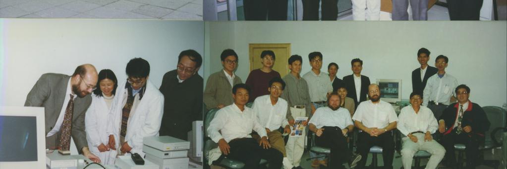
1 The Impact of IT on the Marine Navigator Andrew Eccleston University of Plymouth


2 Marine Navigators with local connections Sir Francis Drake Sir Francis Chichester


3
4 Tasksfor the Marine Navigator Navigation Collision Avoidance Communications Ship Stability Logs, Autopilots... Weather

")
5 Merchant Navy Deck Officer Navigating Officer -Containerships Lots of I and T, but no (digital) computers

6 Raindrop-size distributions PhD Meteorology ICL 1900, cards, paper tape, Commodore PET


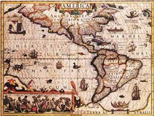
7 Met Office Radar Research Laboratory UK Weather Radar Network PDP 11/40, VAX 11/750, Macro 11, VMS
8 1984Founded company delivering meteorological/hydrological systems Highway Ice-Prediction, River Flow-Forecasting Desktop/Laptop PCs, Xenix, MS-DOS


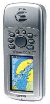
9 1988Co-founded company delivering TV weather services Challenged Met Office domination Silicon Graphics, Indigo, O2, Irix


10 1993Both companies acquired by US-based parent of WSI Expanded in international Aviation and Media Sun, HP Unix workstations

11
12 Interim Management assignments Quality Management in automotive sector Media Products in 3G Telecoms startup


13 2002-University of Plymouth Marine Studies Programmes

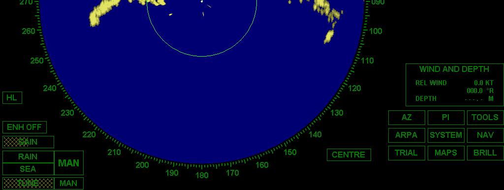
14 Tasksfor the Marine Navigator Navigation Collision Avoidance Communications Ship Stability Logs, Autopilots... Weather


15 Ocean Navigation -in the past


16 Ocean Navigation Sextant


17 Ocean Navigation GPS x


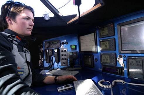
18 Coastal Navigation

19
20 Coastal Navigation IT version ECDIS Chartplotter Ship Yacht
21 Collision Avoidance The Marine Navigator would like to avoid this!

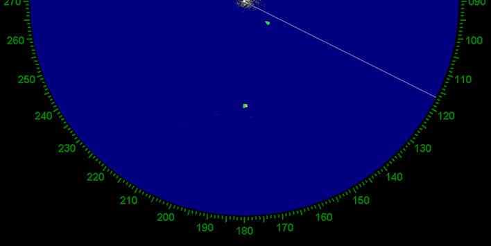
22 Pre-IT Radar
23 Ship s Vector 1024 x x 1030 x 1036 True Course TCPA CPA Ship s Head Relative Track


24 ARPA Automated Radar Plotting Aid
25 Communications 1970 s Ships Radio Room with Radio Officer
26 Modern Ship s Radio Installation on the Bridge


27 OSTAR Competitor - Vijaya


28 Vijaya -Chartable Iridium Phone
29 OSTAR Competitor - De Franschman
30 De Franschman Data Comms SSB Radio Modem
31 AIS - Automatic Identification System As part of the global maritime safety system, ships over 300 tonsare now required to broadcast their positions using AIS. A ship transmits "dynamic" information at intervals of between 2 and 12 seconds depending on the vessel's speed or 3 minutes if at anchor. MMSI number Navigation status, e.g. 'at anchor' or 'underway' Ground speed, from 0 to 102 knots in steps of 0.1 knots Rate of turn, 0 to 720 degrees per minute Position (GPS latitude and longitude) Heading and Course over Ground Time stamp
32 AIS - Automatic Identification System Then every six minutes "static" information is transmitted: MMSI number Callsign Ship's name Type of ship Width, length and draught Antenna Location Destination Estimated time of arrival (ETA) Voyage related information such as draught, cargo, destination, ETA and route plan is generally manually entered and updated by the bridge team.


33 AIS - Automatic Identification System


34 AIS Automatic Identification System
35 GMDSS Global Maritime Distress and Safety System


36 GMDSS Components Digital Selective Calling VHF Radio NAVigation TEXt receiver Emergency Postion Indicating Radio Beacon
37
38 Ship Stability The Marine Navigator would like to avoid this!
39


40 Ship Stability the IT version
41 Logs, Autopilots Log measures distance/speed travelled Autopilot steers the vessel
42


43 Modern Logs NMEA data Seatalk data


44


45 Modern Yacht Autopilot
46
47
48


49 Weather


50 Ellen McArthur ELLEN MACARTHUR
 Global Dataset Coarse Grid Up to 10 days Met Office NEC")
51 Forecasting the Weather by Global Observations Physics Maths Model Large Scale Topography Computer SUPER COMPUTER Forecast Data GRIB (GRIdded Binary) Global Dataset Coarse Grid Up to 10 days Met Office NEC SX-8
52 OSTAR WINNER-Franco Manzoli
53 Impact of ITon the Marine Navigator Enhanced Safety Change of scope of role New skills required Data integration Need to maintain traditional skills

 Cheap broadband")
54 FutureIT forthe Marine Navigator Visual display development Backup for GPS (Galileo) Cheap broadband at sea
55 A cautionary tale
56 Grounding of Royal Majesty RAN AGROUND: Nantucket Shoal June 1995
57 The Facts: Voyage Details Departed Bermuda bound for Boston 1509 Passengers + Crew 677 miles 41 hours
58 The Facts: Navigation Equipment Equipped with GPS, Loran-C, magnetic and gyro compasses, radars, log Integrated Bridge System: Navigation and Command System (NACOS)
59 The Facts: Integrated Bridge System NACOS Loran-C Map Creation Map GPS Lat/Long NMEA 0183 Autopilot Radar +ARPA Gyro Log
60 When she ran aground, the vessel was 17 miles from the position assumed by the Navigating Officer! No injuries The Facts: Marine Casualty Damage and lost revenue: $7m Assumed Track ACTUAL Track
61 How did it happen? Bridge gear was tested before departure and found to be in perfect working order 52 mins after the vessel sailed, the aerial connection to the GPS parted GPS gave an audible alarm, but no-one heard it GPS displayed a warning message, but no-one saw it GPS defaulted to output a DR position based on the gyro and log inputs NACOS continued using this DR position to steer the ship and generate the map OOW monitored the progress of the vessel only by looking at the map display on the ARPA Vessel was being set unnoticed to the SW of the planned track When the OOW sighted a buoy, he did not positively identify it, but assumed it was the one he expected to see The vessel ran aground
62 Lessons Learned Interoperability of IT systems System redundancy Fail-safe error procedures Need to maintain traditional skills


63 Impact of IT on the Marine Navigator Queen Mary Queen Mary 2 Gipsy Moth IV Open 60
AIS Training. AIS Technology in Digital Yacht Products Explained. Digital Yacht Ltd TEL
 AIS Training AIS Technology in Digital Yacht Products Explained Digital Yacht Ltd www.digitalyacht.co.uk TEL + 44 1179 554474 What is AIS? The Automatic Identification System (AIS) is the biggest advance
Analysis of the Royal Majesty Grounding Using SOL
 Analysis of the Royal Majesty Grounding Using SOL Claire Blackett The Intelligent Information Retrieval Group, University College Dublin, Ireland 3 rd Bieleschweig Workshop on Systems Engineering Overview
NC Models. CP390i - GPS Chart Plotters. Addendum to Owner s Manual Issue C to update to Software Version (*)
") CP390i - GPS Chart Plotters (*) NC Models to Owner s Manual Issue 16.50 C 300311 to update to Software Version 16.70 BUILT-IN CHARTS ARE NOT INSTALLED The following paragraphs/pictures are not applicable:
CP390i - GPS Chart Plotters (*) NC Models to Owner s Manual Issue 16.50 C 300311 to update to Software Version 16.70 BUILT-IN CHARTS ARE NOT INSTALLED The following paragraphs/pictures are not applicable:
FURUNO DEEPSEA WORLD Class-A Universal AIS Automatic Identification System. The future today with FURUNO's electronics technology.
 R FURUNO DEEPSEA WORLD Class-A Universal AIS Automatic Identification System Model FA-100 The AIS improves the safety of navigation by assisting in the efficient navigation of ships, protection of the
Universidad Nacional Experimental Marítima del Caribe Vicerrectorado Académico Cátedra de Idiomas Inglés VI. Ingeniería Marítima
 Universidad Nacional Experimental Marítima del Caribe Vicerrectorado Académico Cátedra de Idiomas Inglés VI. Ingeniería Marítima UNIT II. Navigational equipment found onboard ships. Speaking. 1. Can you
Transport System. Telematics. Possibility of integration of navigational information on electronic chart
 Archives of Volume 3 Transport System Issue 2 Telematics May 2010 Possibility of integration of navigational information on electronic chart H. ŚNIEGOCKI a, M. WIELIKI b a Faculty of Navigation, Gdynia
Resolution A.1106(29) Adopted on 2 December 2015 (Agenda item 10)
 Adopted on 2 December 2015 (Agenda item 10)") E ASSEMBLY 29th session Agenda item 10 A 29/Res.1106 14 December 2015 Original: ENGLISH Resolution A.1106(29) Adopted on 2 December 2015 (Agenda item 10) REVISED GUIDELINES FOR THE ONBOARD OPERATIONAL
E ASSEMBLY 29th session Agenda item 10 A 29/Res.1106 14 December 2015 Original: ENGLISH Resolution A.1106(29) Adopted on 2 December 2015 (Agenda item 10) REVISED GUIDELINES FOR THE ONBOARD OPERATIONAL
Doug Miller Milltech Marine Inc. Milltech Marine 1
 Doug Miller Milltech Marine Inc. www.milltechmarine.com Milltech Marine 1 What I ll Cover What is AIS? AIS Transponders AIS Receivers Typical Usage Scenarios What s new and what s coming Questions Milltech
The Captains F O R U M
 The Captains F O R U M THE HUMAN-CENTRED DESIGN FORUM In December last year, the International Maritime Organization (IMO) adopted Performance Standards and approved Guidelines the combined effect of which
RESOLUTION MSC.278(85) (adopted on 1 December 2008) ADOPTION OF THE NEW MANDATORY SHIP REPORTING SYSTEM "OFF THE COAST OF PORTUGAL - COPREP"
 (adopted on 1 December 2008) ADOPTION OF THE NEW MANDATORY SHIP REPORTING SYSTEM OFF THE COAST OF PORTUGAL - COPREP") MSC 85/26/Add.1 RESOLUTION MSC.278(85) SYSTEM OFF THE COAST OF PORTUGAL COPREP THE MARITIME SAFETY COMMITTEE, RECALLING Article 28 of the Convention on the International Maritime Organization concerning
MSC 85/26/Add.1 RESOLUTION MSC.278(85) SYSTEM OFF THE COAST OF PORTUGAL COPREP THE MARITIME SAFETY COMMITTEE, RECALLING Article 28 of the Convention on the International Maritime Organization concerning
Universal Shipborne Automatic Identification System (AIS) Transponder
 Transponder") Universal Shipborne Automatic Identification System (AIS) Transponder What is an AIS? Picture a shipboard radar display, with overlaid electronic chart data, that includes a mark for every significant
Universal Shipborne Automatic Identification System (AIS) Transponder What is an AIS? Picture a shipboard radar display, with overlaid electronic chart data, that includes a mark for every significant
Addendum 1.4_2. (Addendum to MX420 Operator s Manual)
") _2 (Addendum to MX420 ) September, 2007 Table of Contents About this document..1 MX575 Heading & Rate of Turn 2 MX575 as a D/GPS Compass only 2 MX575 as a D/GPS Compass with Navigation Functionality.....4
_2 (Addendum to MX420 ) September, 2007 Table of Contents About this document..1 MX575 Heading & Rate of Turn 2 MX575 as a D/GPS Compass only 2 MX575 as a D/GPS Compass with Navigation Functionality.....4
Sperry Marine Northrop Grumman
 Sperry Marine 2005 Northrop Grumman Table of Contents CHAPTER 1: CHAPTER 2: CHAPTER 3: CHAPTER 4: CHAPTER 5: CHAPTER 6: WHERE ARE YOU GOING? TRANSMITTING HEADING DEVICES DETERMINING HEADING BY SATELLITE
ANNEX 12. RESOLUTION MSC.74(69) (adopted on 12 May 1998) ADOPTION OF NEW AND AMENDED PERFORMANCE STANDARDS
 (adopted on 12 May 1998) ADOPTION OF NEW AND AMENDED PERFORMANCE STANDARDS") RESOLUTION MSC.74(69) (adopted on 12 May 1998) ADOPTION OF NEW AND AMENDED PERFORMANCE STANDARDS THE MARITIME SAFETY COMMITTEE, RECALLING Article 28(b) of the Convention on the International Maritime Organization
RESOLUTION MSC.74(69) (adopted on 12 May 1998) ADOPTION OF NEW AND AMENDED PERFORMANCE STANDARDS THE MARITIME SAFETY COMMITTEE, RECALLING Article 28(b) of the Convention on the International Maritime Organization
CHAPTER 66 QUARTERMASTER (QM) NAVPERS E CH-67
 NAVPERS E CH-67") CHAPTER 66 QUARTERMASTER (QM) NAVPERS 18068-66E CH-67 Updated: July 2016 TABLE OF CONTENTS QUARTERMASTER (QM) SCOPE OF RATING GENERAL INFORMATION NAVIGATION ADMINISTRATOR COMMUNICATIONS ELECTRONIC SYSTEMS
CHAPTER 66 QUARTERMASTER (QM) NAVPERS 18068-66E CH-67 Updated: July 2016 TABLE OF CONTENTS QUARTERMASTER (QM) SCOPE OF RATING GENERAL INFORMATION NAVIGATION ADMINISTRATOR COMMUNICATIONS ELECTRONIC SYSTEMS
THE ELECTRONIC CHART DISPLAY AND INFORMATION SYSTEM (ECDIS) IN CHINA
 IN CHINA") International Hydrographic 'Review, Monaco, LXIX(2), September 1992 THE ELECTRONIC CHART DISPLAY AND INFORMATION SYSTEM (ECDIS) IN CHINA by The Research Group on ECDIS 1 Abstract This paper presents a
International Hydrographic 'Review, Monaco, LXIX(2), September 1992 THE ELECTRONIC CHART DISPLAY AND INFORMATION SYSTEM (ECDIS) IN CHINA by The Research Group on ECDIS 1 Abstract This paper presents a
The FA-50 offers accurate information for collision avoidance
 The FA-50 offers accurate information for collision avoidance with GPS antenna GPA-017S FURUNO s FA-50 class-b AIS transponder receives navigation data from AIS-equipped vessels nearby that can be utilized
The Future in Marine Radio Communication GMDSS. Department of Transportation United States Coast Guard
 The Future in Marine Radio Communication GMDSS Department of Transportation United States Coast Guard Do you use a Maritime Radio System? If so, the new Global Maritime Distress and Safety System (GMDSS)
Emergency Marine Communications
 Emergency Marine Communications Presented by: Steve Chamberlin Content:Chuck Hawley Safety at Sea Seminar US Sailing Goals of Emergency Communications To alert rescue services to your situation To get
ESSnet pilot AIS data. Anke Consten, Eleni Bisioti and Olav Grøndal (23 February 2017, Sofia)
") ESSnet pilot AIS data Anke Consten, Eleni Bisioti and Olav Grøndal (23 February 2017, Sofia) Overview 1. Introduction 2. Deliverables ESSnet pilot AIS data 3. Data access and handling 4. Quality of AIS
ESSnet pilot AIS data Anke Consten, Eleni Bisioti and Olav Grøndal (23 February 2017, Sofia) Overview 1. Introduction 2. Deliverables ESSnet pilot AIS data 3. Data access and handling 4. Quality of AIS
NMEA2000- Par PGN. Mandatory Request, Command, or Acknowledge Group Function Receive/Transmit PGN's
 PGN Number Category Notes - Datum Local geodetic datum and datum offsets from a reference datum. T The Request / Command / Acknowledge Group type of 126208 - NMEA - Request function is defined by first
GPSMAP 700 series owner s manual
 GPSMAP 700 series owner s manual Introduction Introduction WARNING See the Important Safety and Product Information guide in the product box for product warnings and other important information. This manual
R4 AIS Class A Transponder System
 Saab TransponderTech R4 AIS Class A Transponder System Operator Manual This page is intentionally empty i Copyright The entire contents of this manual and its appendices, including any future updates and
Introduction...2 Content...2 Multi-Function Display Software Update...2 AIS Overview...2
 SKIPPERS NOTES Yacht Sea Essay of Hamble Newsletter No 02/16 Introduction This is an occasional document issued by the Yacht Secretary, which will be placed on the CSD website and/or sent to all CSSA approved
The FA-30 delivers Real-Time AIS information to navigation systems providing critical collision avoidance information
 The FA-30 delivers Real-Time AIS information to navigation systems providing critical collision avoidance information Acquisition and tracking of traffic around your vessel is absolutely necessary for
SOLAS Compliant Navigation Systems On Naval Vessels
 SOLAS Compliant Navigation Systems On Naval Vessels D C Bradley, A Scicluna BAE Systems Australia Defence Pty Ltd, Williamstown, VIC 3016, Australia david.bradley4@baesystems.com, andrew.scicluna@baesystems.com
COMMAND-DEQ IBS Integrated Bridge System
 COMMAND-DEQ IBS Integrated Bridge System Page : 1 / 15 NAVIGATION BRIDGE 1 Navigation System 1.1 General The total Navigation System is based on «IBS» concept (Integrated Bridge System) The navigation
Global Maritime Distress and Safety System (GMDSS)
") Global Maritime Distress and Safety System (GMDSS) Global Maritime Distress and Safety System (GMDSS) BACKGROUNG, APPLICATION, DEFINITION GMDSS (Background) SOLAS 74 Ships 1600 TRG Radio Installation Ships
Global Maritime Distress and Safety System (GMDSS) Global Maritime Distress and Safety System (GMDSS) BACKGROUNG, APPLICATION, DEFINITION GMDSS (Background) SOLAS 74 Ships 1600 TRG Radio Installation Ships
RECOMMENDATION ITU-R M.825-3*, **
 Rec. ITU-R M.825-3 1 RECOMMENDATION ITU-R M.825-3*, ** CHARACTERISTICS OF A TRANSPONDER SYSTEM USING DIGITAL SELECTIVE CALLING TECHNIQUES FOR USE WITH VESSEL TRAFFIC SERVICES AND SHIP-TO-SHIP IDENTIFICATION
National Maritime Center
 National Maritime Center Providing Credentials to Mariners (Sample Examination) Page 1 of 6 Choose the best answer to the following Multiple Choice Questions. 1. The following questions are based on Chart
TECHNICAL SPECIFICATION. VisionMaster FT Radar & Chart Radar Features CAT1 and ECAT2
 TECHNICAL SPECIFICATION VisionMaster FT Radar & Chart Radar Features CAT1 and ECAT2 The following specifications relate to release 4.1.3 series of VisionMaster FT (IEC62388 version) RADAR SYSTEM PERFORMANCE
TECHNICAL COMMITTEE 80: MARITIME NAVIGATION AND RADIOCOMMUNICATION EQUIPMENT AND SYSTEMS INTERNATIONAL ELECTROTECHNICAL COMMISSION
 TECHNICAL COMMITTEE 80: MARITIME NAVIGATION AND RADIOCOMMUNICATION EQUIPMENT AND SYSTEMS INTERNATIONAL ELECTROTECHNICAL COMMISSION IEC TECHNICAL COMMITTEE 80: MARITIME NAVIGATION AND RADIOCOMMUNICATION
SAFETY EQUIPMENT AND PREPARATION. S/V Odette USA 5619
 SAFETY EQUIPMENT AND PREPARATION S/V Odette USA 5619 Odette5619@gmail.com COMMUNICATION PREPARATION Dedicate dock time for crew to familiarize themselves with all communication equipment: VHF: Walk through
GUIDELINES ON THE DESIGN AND USE OF PORTABLE PILOT UNITS INTERNATIONAL MARITIME PILOTS ASSOCIATION
 GUIDELINES ON THE DESIGN AND USE OF PORTABLE PILOT UNITS INTERNATIONAL MARITIME PILOTS ASSOCIATION WITH TECHNICAL INPUT FROM Comité International Radio-Maritime (CIRM) 2 FOREWORD With the increasing use
Maritime Electronics Supporting Unmanned Vessels
 EU-Japan Policy Workshop Maritime Electronics Supporting Unmanned Vessels November 11 th, 2016 TAKUO KASHIWA, Ph.D Furuno Electric Co., Ltd. Agenda Positioning Technologies for Vessel s position Technologies
Introducing The World s First DGPS/AIS Navigation System!
 Introducing The World s First DGPS/AIS Navigation System! MX420 Navigation System: The Most Advanced DGPS/AIS Navigation Solution. MX420AIS Pioneering The Future Standards Of Navigation All navigation
GMDSS RADIO INSTALLATION
 Ship s name: N.R. Survey: GMDSS RADIO INSTALLATION (Res. A.1053(27)) INITIAL (Newconstruction) PERIODICAL RENEWAL Sea areas: A1 Methods of maintenance: Duplication of (Reg. IV/12-15) A1+A2 (Reg. IV/15)
The Role of Automatic Identification System (AIS) in Enhancing Vessel Traffic Management By Capt. Ehab Ibrahim Etman
 in Enhancing Vessel Traffic Management By Capt. Ehab Ibrahim Etman") The Role of Automatic Identification System (AIS) in Enhancing Vessel Traffic Management By Capt. Ehab Ibrahim Etman Abstract The International Maritime Organization (IMO) adopted a new requirement for
The Role of Automatic Identification System (AIS) in Enhancing Vessel Traffic Management By Capt. Ehab Ibrahim Etman Abstract The International Maritime Organization (IMO) adopted a new requirement for
NMEA 2000 Parameter Group Numbers and Description as of August 2007 NMEA 2000 DB Ver
 Category General & or Mandatory ISO Acknowledgment This message is provided by ISO 11783 for a handshake mechanism between transmitting and receiving devices. This message is the possible response to acknowledge
ROUTEING OF SHIPS, SHIP REPORTING AND RELATED MATTERS. Establishment of a Mandatory Ship Reporting System in the
 INTERNATIONAL MARITIME ORGANIZATION E SUB-COMMITTEE ON SAFETY OF NAVIGATION 48th session Agenda item 3 IMO NAV 48/3/2 11 April 2002 Original: ENGLISH ROUTEING OF SHIPS, SHIP REPORTING AND RELATED MATTERS
Automatic Identification System And Its Integration On The Great Lakes And St. Lawrence Seaway
 I Automatic Identification System And Its Integration On The Great Lakes And St. Lawrence Seaway Prepared by Melissa Hopkins - 20010575 Adam Howell - 20001016 David Ingram - 20001119 Andrew Wakeham - 20010422
(In)security of smart transportation at sea
security of smart transportation at sea") Application Security: internet, mobile ed oltre (In)security of smart transportation at sea Dr. Marco Balduzzi Venezia, 3 ottobre 2014 (In)security of smart transportation at sea - DR. MARCO BALDUZZI 3.10.2014
Application Security: internet, mobile ed oltre (In)security of smart transportation at sea Dr. Marco Balduzzi Venezia, 3 ottobre 2014 (In)security of smart transportation at sea - DR. MARCO BALDUZZI 3.10.2014
AIS6 / MFR6 User Manual
 AIS6 / MFR6 User Manual Important Features at a glance Below you will find a brief summary of the main features of your Seatec AIS6 / MFR6. Your Seatec AIS6 / MFR6 will be your reliable partner for a safe
FURUNO DEEPSEA WORLD Class-A Universal AIS Automatic Identification System. The future today with FURUNO's electronics technology.
 R FURUNO DEEPSEA WORLD Class-A Universal AIS Automatic Identification System Model FA-100 The AIS improves the safety of navigation by assisting in the efficient navigation of ships, protection of the
RESOLUTION MSC.230(82) (adopted on 5 December 2006) ADOPTION OF AMENDMENTS TO THE EXISTING MANDATORY SHIP REPORTING SYSTEM "IN THE STOREBÆLT (GREAT
 (adopted on 5 December 2006) ADOPTION OF AMENDMENTS TO THE EXISTING MANDATORY SHIP REPORTING SYSTEM IN THE STOREBÆLT (GREAT") MSC 82/24/Add.2 RESOLUTION MSC.230(82) MANDATORY SHIP REPORTING SYSTEM IN THE STOREBÆLT (GREAT BELT) TRAFFIC AREA THE MARITIME SAFETY COMMITTEE, RECALLING Article 28(b) of the Convention on the International
MSC 82/24/Add.2 RESOLUTION MSC.230(82) MANDATORY SHIP REPORTING SYSTEM IN THE STOREBÆLT (GREAT BELT) TRAFFIC AREA THE MARITIME SAFETY COMMITTEE, RECALLING Article 28(b) of the Convention on the International
HIGH PERFORMANCE MARITIME. em-trak S100 PRODUCTS. Antenna splitter. Product Manual. High Performance Maritime Products
 em-trak S100 MARITIME PRODUCTS HIGH PERFORMANCE Antenna splitter Product Manual High Performance Maritime Products www.em-trak.com 201-0206:3 Contents 1 - Notices...1 1.1 - Safety warnings...1 1.2 - General
RESOLUTION MSC.229(82) (adopted on 5 December 2006) ADOPTION OF A NEW MANDATORY SHIP REPORTING SYSTEM "IN THE GALAPAGOS PARTICULARLY SENSITIVE SEA
 (adopted on 5 December 2006) ADOPTION OF A NEW MANDATORY SHIP REPORTING SYSTEM IN THE GALAPAGOS PARTICULARLY SENSITIVE SEA") MSC 82/24/Add.2 RESOLUTION MSC.229(82) IN THE GALAPAGOS PARTICULARLY SENSITIVE SEA AREA (PSSA) (GALREP) THE MARITIME SAFETY COMMITTEE, RECALLING Article 28(b) of the Convention on the International Maritime
MSC 82/24/Add.2 RESOLUTION MSC.229(82) IN THE GALAPAGOS PARTICULARLY SENSITIVE SEA AREA (PSSA) (GALREP) THE MARITIME SAFETY COMMITTEE, RECALLING Article 28(b) of the Convention on the International Maritime
VHF / DSC - COMMUNICATION. Message by conversation on VHF
 COMUNICATIONS VHF s VHF / DSC - COMMUNICATION Non-GMDSS vessels (e.g. small vessels) Announcement & acknowledgement on VHF GMDSS vessels Announcement & acknowledgement by Digital Selective Calling (DSC)
INTERNATIONAL STANDARD
 INTERNATIONAL STANDARD IEC 60872-2 First edition 1999-01 Maritime navigation and radiocommunication equipment and systems Radar plotting aids Part 2: Automatic tracking aids (ATA) Methods of testing and
Is the new technology safe for navigation in coastal waters and archipelagos?
 3.35.20 Is the new technology safe for navigation in coastal waters and archipelagos? As near misses not are reported we take a look at the groundings Combat boat CB 90 (mostly) Thank you Lars-Erik! ECS
KS-200A/B. ˵à Êé. AIS Class B Transponder KS-200A AIS Receiver KS-200B
 R KS-200A/B KS-200A/B ˵à Êé OPERATOR`S MANUAL AIS Class B Transponder KS-200A AIS Receiver KS-200B SAFETY INSTRUCTIONS Safety Instructions for the Operator WARNING Do not open the equipment. Only qualified
Using AIS to identify and investigate ferry accidents
 Using AIS to identify and investigate ferry accidents David Hewson Antenna Network Manager Genscape Vesseltracker info@genscape.com DE: +49 (0) 97 07 86 10 EU: +31 20 524 4089 Background Vesseltracker
IIMS TRAINING SEMINAR
 Title slide Identifying electronic equipment on today s advanced yachts? NAVIGATION EQUIPMENT non type approved 1 x Raymarine GPS ant/head 1 x Raymarine Fluxgate Compass 1 x Raymarine ST60 instruments
GMDSS for Recreational Boaters
 GMDSS for Recreational Boaters OVERVIEW The Global Maritime Distress and Safety System (GMDSS) is an international system using advanced communications technology. Development of GMDSS was initiated by
ANNEX ANNEX. Accompanying the document. Commission Implementing Regulation
 Ref. Ares(2018)3546601-04/07/2018 EUROPEAN COMMISSION Brussels, XXX [ ](2018) XXX draft ANNEX ANNEX Accompanying the document Commission Implementing Regulation on technical specifications for vessel tracking
GMDSS modernisation and e-navigation: spectrum needs
 ETSI Workshop "Future Evolution of Marine Communication", 7-8 November 2017, Sophia Antipolis, France GMDSS modernisation and e-navigation: spectrum needs Karlis Bogens BR Terrestrial Services Department
GPSMAP 500/700 Series and echomap 50/70 Series Owner s Manual
 GPSMAP 500/700 Series and echomap 50/70 Series Owner s Manual February 2013 190-01556-00_0A Printed in Taiwan All rights reserved. Under the copyright laws, this manual may not be copied, in whole or in
GPSMAP. 4000/5000 series owner s manual
 GPSMAP 4000/5000 series owner s manual 2009 Garmin Ltd. or its subsidiaries All rights reserved. Except as expressly provided herein, no part of this manual may be reproduced, copied, transmitted, disseminated,
All brand and product names are trademarks, registered trademarks or service marks of their respective holders.
 IMPORTANT NOTICES General The operator of this equipment must read and follow the descriptions in this manual. Wrong operation or maintenance can cancel the warranty or cause injury. Do not copy any part
ATTACHMENT E. How to Conduct a GMDSS Inspection.
 Page 1 of 7 NOTE: This document is an excerpt from The Report and Order In the Matter of Amendment of the Commission's Rules Concerning the Inspection of Radio Installations on Large Cargo and Small Passenger
Usage AIS Data for Analyzing Ship s Motion Intensity
 International Journal on Marine Navigation and Safety of Sea Transportation Volume 1 Number 3 September 2007 Usage AIS Data for Analyzing Ship s Motion Intensity K. Naus, A. Makar & J. Apanowicz Polish
AIS 3410 Automatic Identification System
 Automatic Identification System General Unknown vessel on my starboard bow... radio communications like this are a commonplace occurrence for the officer on watch during night time, especially in coastal
Saab TransponderTech
 Saab TransponderTech R4 Combined AIS & Navigation System This page is intentionally empty Copyright The content of this document and its attachments shall remain our property. They may not without our
SRT Marine Technology. LD2342 V1.4 Page 1 of 22
 LD2342 V1.4 Page 1 of 22 LD2342 V1.4 Page 2 of 22 2 LD2342 V1.4 Page 3 of 22 GENERAL WARNINGS All marine Automatic Identification System (AIS) units utilise a satellite based system such as the Global
السلطة البحرية االردنية Jordan Maritime Authority
 السلطة البحرية االردنية السلطة البحرية االردنية Humans have always been interested in where things are السلطة البحرية االردنية One of the basic questions have always been where I am? which leads to where
LD2342 USWM V1.6. LD2342 V1.4 Page 1 of 18
 LD2342 USWM V1.6 LD2342 V1.4 Page 1 of 18 GENERAL WARNINGS All Class A and Class B marine Automatic Identification System (AIS) units utilize a satellite based system such as the Global Positioning Satellite
VHF 110/210 AIS Series. Owner s Manual
 VHF 110/210 AIS Series Owner s Manual Table of Contents Introduction...1 Radio Overview... 1 Handset Overview... 1 Home Screen... 1 System Status Icons... 1 Basic Operation... 2 Turning On and Off the
ANNUAL OF NAVIGATION 19/2012/part 1
 ANNUAL OF NAVIGATION 19/2012/part 1 PAWEŁ BANYŚ, THORALF NOACK, STEFAN GEWIES German Aerospace Center (DLR), Institute of Communications and Navigation (IKN) ASSESSMENT OF AIS VESSEL POSITION REPORT UNDER
Protection Augmentation Toughness and Alternatives of GNSS. Melaha 2016 Concord Al-Salam Hotel Cairo, April 25,2016 Refaat Rashad
 Protection Augmentation Toughness and Alternatives of GNSS Melaha 2016 Concord Al-Salam Hotel Cairo, April 25,2016 Refaat Rashad Road Map of the Presentation 1- How Good are GNSS 2- How Vulnerable are
Standard Operating Procedures for: VHF Marine Radio
 Serenity Houseboat I. Overview Standard Operating Procedures for: VHF Marine Radio VHF, or Very High Frequency, marine radio is the standard method of communication between vessels. Marine radio equipment
Using a Pilot Laptop with the AIS pilot plug - observed errors and difficulties
 Using a Pilot Laptop with the AIS pilot plug - observed errors and difficulties 2 nd November 2008 The following pages and images detail the errors found and experience in using his Pilot Laptop by a Australian
SIMULATORS USES FOR TRAINING OF MERCHANT VESSELS OFFICERS
 Journal of KONES Powertrain and Transport, Vol. 17, No. 3 2010 SIMULATORS USES FOR TRAINING OF MERCHANT VESSELS OFFICERS Henryk niegocki Gdynia Maritime University, Department of Navigation Jana Paw a
VHF 110/210 AIS Series. Owner s Manual
 VHF 110/210 AIS Series Owner s Manual 2017 Garmin Ltd. or its subsidiaries All rights reserved. Under the copyright laws, this manual may not be copied, in whole or in part, without the written consent
National Marine Electronics Association International Marine Electronics Association. Technical Bulletin
 National Marine Electronics Association International Marine Electronics Association Technical Bulletin Amendment to NMEA 0183 Version 4.10 # AT 0183 20130815 NMEA 0183 Amendment An amendment is a technical
Fisheries and Marine Resources (Automatic Identification System) Regulations
 Regulations") Fisheries and Marine Resources (Automatic Identification System) Regulations 2016 GN No. 116 of 2016 Government Gazette of Mauritius No. 47of 28 May 2016 THE FISHERIES AND MARINE RESOURCES ACT Regulations
Fisheries and Marine Resources (Automatic Identification System) Regulations 2016 GN No. 116 of 2016 Government Gazette of Mauritius No. 47of 28 May 2016 THE FISHERIES AND MARINE RESOURCES ACT Regulations
THE COMPLETE GUIDE TO. Automatic Identification System
 THE COMPLETE GUIDE TO Automatic Identification System The Complete Guide to Automatic Identification Systems Leica Geosystems Inc. Copyright 2001 Leica Geosystems Inc. table this is of the contents chapter
ACR AISLINK CA1 Class A AIS Transceiver User Manual
 ACR AISLINK CA1 Class A AIS Transceiver User Manual Contents 1 Notices...5 1.1 Safety warnings... 5 1.2 General notices... 5 1.3 Regulatory Statements... 6 2 Introduction...7 2.1 About AIS... 7 2.2 Static
GPSMAP. 6000/7000 series owner s manual
 GPSMAP 6000/7000 series owner s manual 2010 Garmin Ltd. or its subsidiaries Garmin International, Inc. 1200 East 151 st Street, Olathe, Kansas 66062, USA Tel. (913) 397.8200 or (800) 800.1020 Fax (913)
RULES FOR THE CONSTRUCTION AND CLASSIFICATION OF MOBILE OFFSHORE DRILLING UNITS TITLE MOBILE OFFSHORE DRILLING UNITS NAUTIC AND ELECTRONICS CHAPTERS
 PARTE II RULES FOR THE CONSTRUCTION AND CLASSIFICATION OF MOBILE OFFSHORE DRILLING UNITS TITLE MOBILE OFFSHORE DRILLING UNITS SECTION 8 NAUTIC AND ELECTRONICS CHAPTERS A B C D SCOPE TECHNICAL DOCUMENTATION
L AGENCE NATIONALE DES FREQUENCES (ANFR) From Titanic to satellite from Morse to digital Entry in a new era for the maritime community
 From Titanic to satellite from Morse to digital Entry in a new era for the maritime community") L AGENCE NATIONALE DES FREQUENCES (ANFR) From Titanic to satellite from Morse to digital Entry in a new era for the maritime community ITU regional seminar 6-8 June 2018 St-Petersburg, Russian Federation
L AGENCE NATIONALE DES FREQUENCES (ANFR) From Titanic to satellite from Morse to digital Entry in a new era for the maritime community ITU regional seminar 6-8 June 2018 St-Petersburg, Russian Federation
OPERATION & INSTALLATION MANUAL AIS RX CARBON & AIS RX CARBON +
 OPERATION & INSTALLATION MANUAL AIS RX CARBON & AIS RX CARBON + Version 1.1E True Heading 2010 The manual may not in any aspect be copied without the prior authorization from True Heading AB. 1 REVISSION...
GUIDELINES ON ANNUAL TESTING OF THE AUTOMATIC IDENTIFICATION SYSTEM (AIS)
") INTERNATIONAL MARITIME ORGANIZATION 4 ALBERT EMBANKMENT LONDON SE1 7SR Telephone: 020 7735 7611 Fax: 020 7587 3210 IMO E Ref. T1/10 MSC.1/Circ.1252 22 October 2007 GUIDELINES ON ANNUAL TESTING OF THE AUTOMATIC
INTERNATIONAL MARITIME ORGANIZATION 4 ALBERT EMBANKMENT LONDON SE1 7SR Telephone: 020 7735 7611 Fax: 020 7587 3210 IMO E Ref. T1/10 MSC.1/Circ.1252 22 October 2007 GUIDELINES ON ANNUAL TESTING OF THE AUTOMATIC
Juan GAVIRIA, Sector Leader AFTTR
 Earth Observation in support of the Western Indian Ocean Marine Highway Development and Coastal and Marine Contamination Prevention Project - Oil spill detection & Coral reef monitoring Juan GAVIRIA, Sector
Western Indian Ocean Marine Highway Development and Coastal and Marine Contamination Prevention Project - Oil spill detection & Coral reef monitoring
 Earth Observation in support of the Western Indian Ocean Marine Highway Development and Coastal and Marine Contamination Prevention Project - Oil spill detection & Coral reef monitoring Juan GAVIRIA, Sector
INTEGRATED NAVIGATION SYSTEMS
 INTEGRATED NAVIGATION SYSTEMS Basic terms *integrated navigation system *control system *propulsion system *cargo system *digital processing unit *sensor *electronic circuits *sensor output *pulsed input
Frank Heymann 1.
 Plausibility analysis of navigation related AIS parameter based on time series Frank Heymann 1 1 Deutsches Zentrum für Luft und Raumfahrt ev, Neustrelitz, Germany email: frank.heymann@dlr.de In this paper
A Study on Basic VTS Guideline based on Ship s Operator s Consciousness
 http://www.transnav.eu the International Journal on Marine Navigation and Safety of Sea Transportation Volume 11 Number 4 December 2017 DOI: 10.12716/1001.11.04.04 A Study on Basic VTS Guideline based
INVENTORY FOR HARMONISED INLAND AIS APPLICATION SPECIFIC MESSAGES IN EUROPE
 INVENTORY FOR HARMONISED INLAND AIS APPLICATION SPECIFIC MESSAGES IN EUROPE GUIDELINES OF THE VTT EXPERT GROUP Edition 1.2 Version: 12-07-2017 Author: Vessel Tracking and Tracing Expert Group TABLE OF
Real-time position tracking of traffic ships by ARPA radar and AIS in Busan Harbor, Korea
 J Kor Soc Fish Tech 44(3) 229 238 2008 DOI:103796/KSFT2008443229 Real-time position tracking of traffic ships by radar and in Busan Harbor Korea Dae-Jae LEE* Division of Marine Production System Management
General Information Manual Edition 1.14
 General Information Manual Edition 1.14 i. Copyright The entire contents of this instruction manual, including any future updates, revisions, and modifications, shall remain the property of AMEC at all
A Study on Developing Image Processing for Smart Traffic Supporting System Based on AR
 Proceedings of the 2 nd World Congress on Civil, Structural, and Environmental Engineering (CSEE 17) Barcelona, Spain April 2 4, 2017 Paper No. ICTE 111 ISSN: 2371-5294 DOI: 10.11159/icte17.111 A Study
dkart Navigator 9010
 dkart Navigator 9010 dkart Navigator - purpose dkart Navigator is an electronic navigation chart system specially designed to facilitate all the navigational tasks of mariner's day-to-day practice. Along
Thank you for buying this AIS antenna splitter.
 Thank you for buying this AIS antenna splitter. This product has been engineered to offer you the highest level of performance and durability and we hope that it will provide many years of reliable service.
Information for all SRC Radio students
 Information for all SRC Radio students To be read before the course! Make sure, you understand Basic Navigation! The standard method of communicating between vessels, and between ship and shore, over distances
National Maritime Center
 National Maritime Center Providing Credentials to Mariners (Sample Examination) Page 1 of 5 Choose the best answer to the following Multiple Choice Questions. 1. The following questions should be answered
Satellite Navigation (and positioning)
") Satellite Navigation (and positioning) Picture: ESA AE4E08 Instructors: Sandra Verhagen, Hans van der Marel, Christian Tiberius Course 2010 2011, lecture 1 Today s topics Course organisation Course contents
Satellite Navigation (and positioning) Picture: ESA AE4E08 Instructors: Sandra Verhagen, Hans van der Marel, Christian Tiberius Course 2010 2011, lecture 1 Today s topics Course organisation Course contents
Paper for Consideration by S-100WG3. Report on S-100 Sea trial of KHOA
 S-100WG3-8.1 Paper for Consideration by S-100WG3 Report on S-100 Sea trial of KHOA Submitted by: Executive Summary: Related Documents: Related Projects: Republic of Korea (KHOA) This paper reports the
VHF 115/215 AIS SERIES. Owner s Manual
 VHF 115/215 AIS SERIES Owner s Manual 2018 Garmin Ltd. or its subsidiaries All rights reserved. Under the copyright laws, this manual may not be copied, in whole or in part, without the written consent
GPS Jamming and its impact on maritime navigation
 GPS Jamming and its impact on maritime navigation Dr Alan Grant Research and Development - Special Interest Group 10 th May 2010 Use of GPS in the maritime sector GPS has become the normal means for maritime
echomap CHIRP 40/50/70/90 Series Owner s Manual
 echomap CHIRP 40/50/70/90 Series Owner s Manual January 2016 190-01951-00_0B All rights reserved. Under the copyright laws, this manual may not be copied, in whole or in part, without the written consent