Closed Castner Firing Range Remedial Investigation
|
|
|
- Holly Floyd
- 6 years ago
- Views:
Transcription


1 Closed Castner Firing Range Remedial Investigation Technical Project Planning (TPP) Meeting #3 9:00 AM 1:00 PM Imagine the result
2 Meeting Agenda Meeting Goals Remedial Investigation (RI) Project Objectives Review of Technical Project Planning (TPP) Meeting #2 RI Status Munitions and Explosives of Concern (MEC) Investigation Work Completed Results Munitions Constituents (MC) Investigation Work Performed to Date Results Phase 2 Activities RI Report Schedule Questions and Follow-Up Items 2

3 Safety Moment 3

4 Meeting Goals Review TPP Meeting #2 conclusions Present summary of field work performed to date and preliminary results: MEC Investigation MC Investigation Discuss remaining field work Discuss RI Report Review remaining schedule 4
5 RI Project Objectives Overall Goal: Gather sufficient information to determine the nature and extent of MEC / MC and assess potential risks / hazards at the Closed Castner Firing Range MRS RI Objectives: Conduct RI field investigation to characterize the Closed Castner Firing Range Determine the type (nature), density and distribution (extent) of MEC Determine the concentrations and extent of MC Assess potential risks/hazards to human health, safety and the environment Ensure sufficient data collected to develop remedial alternatives for Feasibility Study phase 5
6 Review of TPP Meeting #2 Meeting held 11 February 2015 Reviewed the project stakeholders Obtained stakeholder input on the plan Confirmed Regulatory concurrence TPP Meeting #2 Discussed the detailed technical approach as presented in the QAPP Reviewed the MMRP and RI project objectives Reviewed and confirmed TPP#1 conclusions 6

7 Actions Completed Since TPP 2 Finalized QAPP Conducted Public Meeting Finalized Explosives Site Plan Completed MEC Investigation Completed Phase I of the MC Investigation 7


8 Castner Range RI Tasks Implement TPP Process TPP Meeting #1 & 2 Complete TPP Meeting #3 Today TPP Meeting #4 ~ April 2017 Develop Planning Documents Complete QAPP March 2015 ESP March 2016 Community Relations Support Public Meeting 1 May 2015 Public Meeting 2 ~ July 2017 RAB Meetings ~ April 2017 RI Report Currently Working 8
9 General RI Approach / Data Gaps Includes MEC and MC investigation Evaluate and utilize previous work, especially: 2012 WAA Field Demonstration Report 2013 ISM Field Demonstration Report Collect additional MEC and MC data to fill data gaps: Vertical and horizontal extent of MEC and MC MEC density outside identified CMUA Identify additional CMUAs in high slopes, if present Transportation potential of MEC and MC from high to low elevations 9
10 RI Technical Approach - MEC Sufficient existing data to: Define boundary CMUAs (i.e., potential target areas) in eastern side of MRS Show that CMUAs were delineated to an accuracy of +/- 250 ft Characterize nature and extent of MEC within CMUAs Phased field investigation will close remaining data gaps: Define boundary of CMUAs, if any, in steep areas within western side of MRS Verify that MEC density throughout MRS outside of CMUAs is < 0.1 MEC/acre to a 95% confidence level Migration potential of MEC (and MC) from higher to lower elevation areas 10
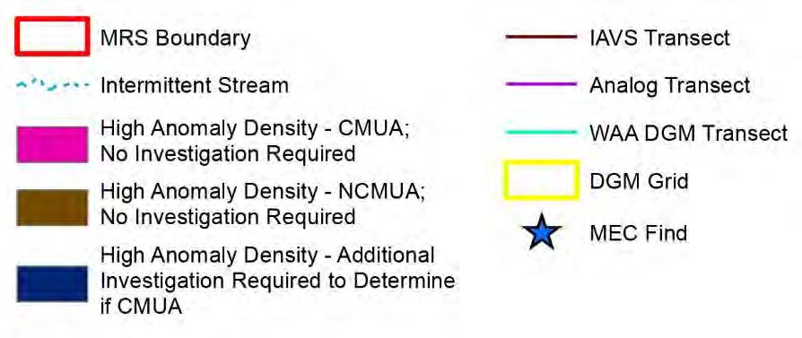
11 Delineated CMUAs 11
12 RI Technical Approach MEC MEC approach uses UXO Estimator to determine statistically valid approaches In areas with slopes < 30%: Investigate approximately 25 acres, using three methods: Reacquisition and intrusive investigation of WAA anomalies (~16 acres) Collection of new DGM data, processing, and intrusive investigation (~5 acres) Analog ( mag and dig ) transect surveys (~ 4 acres) In areas with slopes > 30%: 70 acres via Instrument-assisted visual survey Analog (i.e., mag and dig ) investigation if potential CMUA identified 12
: Phase 2a: Investigation of WAA anomalies 1750 100-ft transect segments selected Reacquire anomalies with GPS and hand-held EMI sensor (e.g,.")
13 RI Technical Approach MEC MEC Phase 1: Instrument Assisted Visual Surveys (areas with slopes > 30%) Meandering path surveys Handheld GPS and EMI sensor No intrusive investigation MEC Phase 2 (areas with slopes < 30%): Phase 2a: Investigation of WAA anomalies ft transect segments selected Reacquire anomalies with GPS and hand-held EMI sensor (e.g,. White s all metals detector) Intrusively investigate with hand tools Record results in tablet PC Handheld EMI Sensor 13
 transects 1,002 randomly placed100-ft transect segments (18% < slopes")
14 RI Technical Approach MEC MEC Phase 2 (areas with slopes < 30%): 14 Phase 2b: DGM Grids x 100 grids (areas with <18% slope) Designed in UXO Estimator EM61-MK2 surveys with RTK DGPS positioning Investigate all anomalies meeting selection criteria with hand tools Record results in tablet PC Phase 2c: Analog ( mag and dig ) transects 1,002 randomly placed100-ft transect segments (18% < slopes < 30%) Use hand-held EMI sensor to identify anomalies Intrusively investigate with hand tools Record results in tablet and GPS anomalies EM61-MK2
 in IAVS areas with anomaly density greater")

15 RI Technical Approach MEC MEC Phase 3 (areas with slopes > 30%) Analog ( mag and dig transects) in IAVS areas with anomaly density greater than 300 anomalies/acre Analog transects to determine the nature and extent of MEC within potential CMUA Handheld EMI Sensor 15 Analog mag and dig
16 MEC Sampling Design Decision Unit Area (acres) 1 MEC/ Acre Sampling Design Required Investigation (acres) Actual Investigation (acres) Conf. MEC Range Investigation Type Area (acres) Level Total Required Areas outside NCMUA 5977 < % Conducted in WAA Analog Transects RI WAA DGM Transect Investigation Note: 1 Acreage represents 6,803 acres of Castner Range (from GIS files) minus the known concentrated munitions use areas. 2 Requires that no UXO are found to confirm hypothesis RI DGM Grid RI Total Investigation:
17 RI Approach - MEC 17

18 IAVS Results 18
19 Analog Transect Results 19
20 New DGM Grids 20
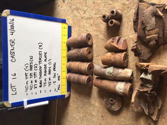
21 RI MEC Finds Target ID Location MEC Found MEC Type NA - Surface Grid 20 37mm High Explosive (HE) Projectile Projectile WAA-1441 Lot 8 M19A1 Rifle Grenade, White Phosphorus (WP) Grenades WAA-1735 Lot 9 40mm M81 Projectile still in cartridge Projectile WAA-0284 Lot 2 37mm HE Projectile Projectile WAA-0391 Lot 2 MK27 Point Detonating (PD) fuze Fuze G Grid 24 60mm Mortar fuzed Mortar 21


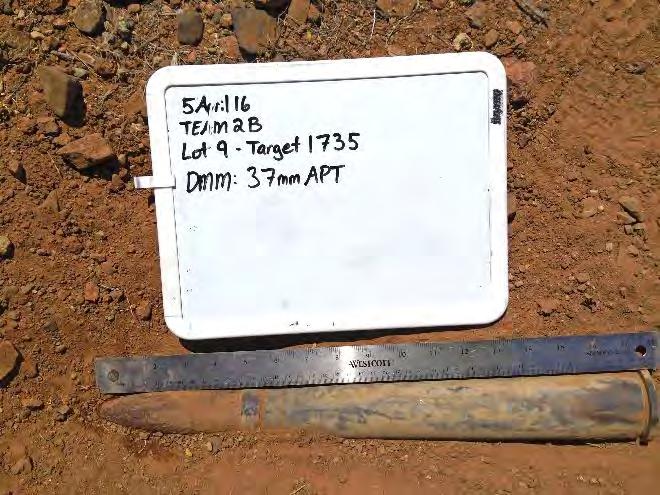
22 MEC Finds Grid 20 on surface WAA-0284 Target G WAA-0391 WAA-1735 Target WAA

23 RI Dig Results 23

24 RI Dig Results - North 24

25 RI Dig Results - Central 25

26 RI Dig Results - South 26

27 RI and Historical MEC Finds 27

28 RI and Historical MEC Finds - North 28
29 RI and Historical MEC Finds - Central 29

30 RI and Historical MEC Finds - South 30

31 Munitions Density Estimate Munitions Density 31

32 Munitions Density Estimate - North Munitions Density 32

33 Munitions Density Estimate - Central Munitions Density 33

34 Munitions Density Estimate - South Munitions Density 34

35 CMUA 23 35

36 Revised CMUAs 36
37 Revised CMUAs CMUA Location Original Size (acres) CMUA Expansion Size (acres) Revised Size (acres) Comments Four expansion areas and merged with CMUA Two expansion areas One expansion area One expansion area Was not considered a CMUA in the QAPP based solely on WAA dig results Now included in CMUA New CMUA identified during RI New CMUA identified during RI Sub-total: NCMUA Total:
38 MEC Recommendations CMUAs Incorporate area of CMUA expansion boundaries NCMUA Re-calculate the MEC density Additional investigation not recommended; original hypotheses likely impossible to prove given large number of MEC found. Recommend also including historical data to qualitatively determine residual MEC hazard. Revise CSM 38
39 Break 39

40 MC RI Program Elements Elements include: Incremental Sampling Methodology (ISM) Discrete sampling (soil, surface water, sediment) Sampling associated with MEC Phased approach to meet TCEQ delineation requirements Based on ISM Demonstration Report Lead, copper, zinc primary MC Ecological receptors will likely drive assessment level 40
 Propellant used in rockets Example of MC deposition")
41 MC Explosives (USEPA Method 8330B) Materials inside munitions 16 separate constituents including TNT, RDX Metals (USEPA Method 6010B) Small arms ammunition, munition casings antimony, arsenic, beryllium, copper, lead, nickel, zinc Perchlorate (USEPA Method 6850) Propellant used in rockets Example of MC deposition 41

42 ISM Delineation Phase I 149 Area-Wide Sample Locations Within CMUAs identified prior to RI MEC data collection 1-acre decision units Separate mobilization to resample DU locations with laboratory QC issues for explosives Laboratory Analysis Explosives, metals all samples Perchlorate only samples collected near former rocket ranges 42
43 Phase 1 ISM Locations 43
44 ISM Results & Affected Property Plotted results of 2011/2012 Study and 2016 RI Screened against: Ecological benchmarks Human Health Tier 1 PCLs ( Tot Soil comb ) Assumes GW Soil pathway will be closed during Phase II Estimated Affected Property Areas Results >Residential Assessment Level Driven by ecological benchmarks Some human health exceedances ( Tot Soil comb ) 44
45 ISM Results - Metals 45
46 Phase II ISM Locations Identified Phase II Step Out Locations Within newly identified CMUAs To complete delineation of Affected Property Areas Phase II Locations Limited by: Steep terrain in some areas Range boundary to the north (separate RI planned) Range boundary to the east (Highway 54 boundary) 46
47 Phase II ISM Locations 47
 4 samples at base of berm Laboratory analysis for")
48 Backstop Berms- Phase I 10 Berms Identified using LIDAR Data Discrete Soil Sampling 2 samples per berm, three depth intervals (0-1, 1-2, 2-3 ) 4 samples at base of berm Laboratory analysis for metals 48
49 Phase I Berm Results & Phase II Locations Four berms had sample results above assessment level Lead was the only metal exceeding One lead result (Berm 1) exceeded human health Tot Soil comb PCL Phase II sampling will be performed to: Delineate lead Have a sufficient number of results to perform statistical comparisons to the PCL 49

50 Berm Results and Phase II Locations 50
51 Arroyo Sampling - Phase I Arroyo Soil Delineation Provides information on MC transport from steep areas 52 discrete sediment sample locations in depositional areas Samples collected from 0-6 in depth If located in CMUA, samples collected at 0-6 and Analyzed for metals Surface Water Samples Two events: dry weather and wet weather performed in Phase I Seep sampling 18 locations targeted; 4 locations contained water Samples analyzed for metals Arroyo surface water samples 6 locations targeted Dry event and 48 hours after rain event: No water present in arroyos 51
52 Planned Surface Water and Sediment Sampling Locations 52

 Seep 53")
53 Surface Water Sampling Types Arroyo Sampling Location (dry) Seep Sampling Location 53
54 Phase I Sediment Results Arsenic, Nickel, and Zinc exceeded Ecological Screening Levels ( benchmarks ) Arsenic exceeded human health Tot Soil comb at two locations Results for the two locations at the downgradient Range boundaries were less than screening levels Phase II sampling will be performed for Zinc and Arsenic 54

55 Phase I Sediment Results & Phase II Locations 55
56 Surface Water Results No water was present in the arroyos during the dry sampling event or 48 hours after the rain event Of the potential seep locations, four contained sufficient water for sampling Metals results compared to Freshwater SW RBELs Only one sample had a result above the screening level Dissolved copper exceeded Freshwater Chronic Aquatic Life SW RBEL Water was only present at this location during the wet event; so acute criteria apply. The single exceedance will be handled in the risk assessment. 56
57 Phase I Seep Results 57
58 Soil to Groundwater Pathway - Phase II Vertical delineation Discrete borings in 3 DUs with highest lead concentration BF052 (lead 1,520 mg/kg) CN073 (lead 1,320 mg/kg) DG070 (lead 5,030 mg/kg) 3 Borings per DU to depth of 20 feet Locations determined based on field screening for lead with XRF 3 depth intervals sampled (0-0.5 inches bgs, interval with the highest XRF results, and the bottom of the boring) If XRF result from bottom of boring exceed background, boring will be advanced an additional 10 feet 58
59 Phase II Boring Locations 59
60 Soil to Groundwater Pathway - Phase II GW Soil PCL Determination Collect samples for remaining Tier 2 parameters during Phase II ph collected during Phase I SPLP analyses performed on Phase I samples Groundwater Assessment Groundwater Assessment performed only if necessary based on vertical delineation results Groundwater Assessment, if necessary, performed in Phase III If refusal encountered in Phase II borings, GW Soil Pathway will be considered incomplete 60
61 RI Report Document and evaluate data (both MEC and MC findings) Update CSM Report on nature and extent of MEC and MC Prepare HHRA and SLERA Prepare MEC Hazard Assessment Update MRSPP Conclusions of the RI Report provide the foundation to develop remedial alternatives during a future Feasibility Study 61
62 Upcoming Project Schedule Phase 2 MC Field Work January / February 2017 RAB Meeting: ~ April 2017 TPP Meeting #4: ~ April 2017 Draft RI Report: ~ May 2017 Draft Final RI Report: ~ August 2017 Public Meeting: ~ July / August
63 TPP Comments Sylvia A. Waggoner Chief, Compliance Branch Directorate of Public Works Fort Bliss, TX

64 Questions? 64
Closed Castner Firing Range Remedial Investigation
 Closed Castner Firing Range Remedial Investigation Imagine the result Technical Project Planning (TPP) Meeting #2 9:00 AM 1:00 PM Meeting Agenda Meeting Goals and Objectives Project Stakeholder Review
Former Maneuver Area A Remedial Investigation Fort Bliss, Texas. Public Meeting November 16, 2016
 Former Maneuver Area A Remedial Investigation Fort Bliss, Texas Public Meeting November 16, 2016 Agenda Purpose Terminology Location and Use of Former Maneuver Area A Description of the Remedial Investigation
Technical Project Planning Meeting #3 January 20, 2017 Remedial Investigation, Closed Castner Firing Range, Fort Bliss, Texas
 Technical Project Planning Meeting #3 January 20, 2017 Remedial Investigation, Closed Castner Firing Range, Fort Bliss, Texas A stakeholder Technical Project Planning (TPP) Meeting for the Remedial Investigation
MEMORANDUM FORT LEWIS AGREED ORDER RI DEMONSTRATION OF METHOD APPLICABILITY SAMPLING AND ANALYSIS PLAN ADDENDUM FORMER SMALL ARMS RANGES
 MEMORANDUM FORT LEWIS AGREED ORDER RI DEMONSTRATION OF METHOD APPLICABILITY SAMPLING AND ANALYSIS PLAN ADDENDUM FORMER SMALL ARMS RANGES 1.0 INTRODUCTION This memorandum present the results of the Demonstration
Case Study: Advanced Classification Contracting at Former Camp San Luis Obispo
 Case Study: Advanced Classification Contracting at Former Camp San Luis Obispo John M. Jackson Geophysicist USACE-Sacramento District US Army Corps of Engineers BUILDING STRONG Agenda! Brief Site Description
REMEDIAL INVESTIGATION OF THE CLOSED RANGES AT F.E. WARREN AFB: A CASE STUDY
 REMEDIAL INVESTIGATION OF THE CLOSED RANGES AT F.E. WARREN AFB: A CASE STUDY Joint Services Environmental Management Conference March 22, 2006 Presented by Brian Powers, URS Coauthors: John Wright, F.E.
Hazard Level Category
 MEC HA Hazard Level Ricochet Determination Area MRS - Ricochet Area MRS, Safety Buffer Zone/Ricochet Area Site ID: State Game Lands 211 a. Current Use Activities e. Response Alternative 3: f. Response
Final Meeting Minutes. Issued: July 7, Project: Former Camp Butner Restoration Advisory Board (RAB)
") Final Minutes Issued: July 7, 2016 Project: Former Camp Butner Restoration Advisory Board () Date: June 1, 2016, 6:30 PM 8:30 PM Place: Butner Town Hall 415 Central Avenue Butner, North Carolina 27509
Final Minutes Issued: July 7, 2016 Project: Former Camp Butner Restoration Advisory Board () Date: June 1, 2016, 6:30 PM 8:30 PM Place: Butner Town Hall 415 Central Avenue Butner, North Carolina 27509
MEC HA Training Example. San Antonio, TX March 2009
 MEC HA Training Example ASTSWMO Conference San Antonio, TX March 2009 1 Automated Workbook Created to guide the application of the MEC HA and provide documentation of the assessment Documents assessments
Paul Black, Ph.D. Kate Catlett, Ph.D. Mark Fitzgerald, Ph.D. Will Barnett, M.S.
 Paul Black, Ph.D. Kate Catlett, Ph.D. Mark Fitzgerald, Ph.D. Will Barnett, M.S. www.neptuneandco.com 1 High costs for characterization & cleanup of munitions sites Need to be more cost effective Tendency
APPENDIX E INSTRUMENT VERIFICATION STRIP REPORT. Final Remedial Investigation Report for the Former Camp Croft Spartanburg, South Carolina Appendices
 Final Remedial Investigation Report for the Former Camp Croft APPENDIX E INSTRUMENT VERIFICATION STRIP REPORT Contract No.: W912DY-10-D-0028 Page E-1 Task Order No.: 0005 Final Remedial Investigation Report
MEC HA: A Tool in the Decision Making Toolbox
 Munitions and Explosives of Concern - Hazard Assessment MEC HA: A Tool in the Decision Making Toolbox Teresa Carpenter Kari Meier, Ph.D. Environmental and Munitions Center of Expertise 23 June 2015 US
UTAH ARMY NATIONAL GUARD
 SECRETARY OF DEFENSE ENVIRONMENTAL AWARDS 2018 UTAH ARMY NATIONAL GUARD ENVIRONMENTAL RESTORATION, INSTALLATION INTRODUCTION AND BACKGROUND The Wood Hollow Training Area (WHTA) lies adjacent to the Utah
Terminology and Acronyms used in ITRC Geophysical Classification for Munitions Response Training
 Terminology and Acronyms used in ITRC Geophysical Classification for Munitions Response Training ITRC s Geophysical Classification for Munitions Response training and associated document (GCMR 2, 2015,
1. Kevin Pien called the meeting to order at 6:40 p.m. and welcomed everyone.
 PALI TRAINING CAMP RESTORATION ADVISORY BOARD (RAB) MINUTES WEDNESDAY, JULY 30, 2014 KAILUA HIGH SCHOOL CAFETERIA 451 ULUMANU DR KAILUA, ISLAND OF OAHU, HAWAII 1. Kevin Pien called the meeting to order
Trial Use of the USACE Risk Management Method
 Trial Use of the USACE Risk Management Method Case Studies, Initial Findings and Panel Discussion Case Study 1 FUDS Thomas Bachovchin, P.G. Thomas.Bachovchin@ertcorp.com 703-389-3938 James Stuby, P.G.
APPENDIX B RISK ASSESSMENT
 APPENDIX B RISK ASSESSMENT APPENDIX B RISK ASSESSMENT This section presents the results of the munitions (MEC) risk assessment (RA) that addresses the explosive hazards associated with MEC in the Del Rey
Munitions and Explosives of Concern Hazard Assessment (MEC HA) Initiative. Joint Services Environmental Management Conference March 23, 2006
 Initiative. Joint Services Environmental Management Conference March 23, 2006") Munitions and Explosives of Concern Hazard Assessment (MEC HA) Initiative Joint Services Environmental Management Conference March 23, 2006 Purpose of this Briefing Overview Why a MEC HA? Discuss the participants,
Munitions and Explosives of Concern Hazard Assessment (MEC HA) Initiative Joint Services Environmental Management Conference March 23, 2006 Purpose of this Briefing Overview Why a MEC HA? Discuss the participants,
1. Kevin Pien called the meeting to order at 6:45 p.m. and welcomed everyone.
 Page 1 PALI TRAINING CAMP RESTORATION ADVISORY BOARD (RAB) MINUTES WEDNESDAY, DECEMBER 4, 2013 KAILUA HIGH SCHOOL CAFETERIA 451 ULUMANU DR KAILUA, ISLAND OF OAHU, HAWAII 1. Kevin Pien called the meeting
Appendix C: Quality Assurance Project Plan DRAFT Phase II Interim Action Work Plan
 FORA ESCA REMEDIATION PROGRAM Appendix C: Quality Assurance Project Plan DRAFT Phase II Interim Action Work Plan Interim Action Ranges Munitions Response Area Former Fort Ord Monterey County, California
Meeting Minutes Purcell NAGS RI/FS February 23, 2005
 Meeting Minutes Purcell NAGS RI/FS February 23, 2005 Location: 6th floor, ODEQ, Oklahoma City, OK Attendees: Mike Hunter, Morgan Ruther (USACE, Huntsville); Carol Weis, Michelle Rhodes (USACE, Tulsa);
1. David Henkin called the meeting to order at 7:10 p.m. and welcomed everyone.
 Page 1 WAIKANE TRAINING AREA RESTORATION ADVISORY BOARD (RAB) MINUTES WEDNESDAY, FEBRUARY 27, 2013 WAIAHOLE ELEMENTARY SCHOOL CAFETERIA 48-215 WAIAHOLE VALLEY ROAD WAIAHOLE, ISLAND OF OAHU, HAWAII 1. David
NORMALIZATION REPORT GAMMA RADIATION DETECTION SYSTEMS SANTA SUSANA FIELD LABORATORY AREA IV RADIOLOGICAL STUDY VENTURA COUNTY, CALIFORNIA
 NORMALIZATION REPORT GAMMA RADIATION DETECTION SYSTEMS SANTA SUSANA FIELD LABORATORY AREA IV RADIOLOGICAL STUDY VENTURA COUNTY, CALIFORNIA 1.0 INTRODUCTION Gamma detection systems scan the ground surface
Leading Change for Installation Excellence
 MEC Assessment Using Working Dogs Hap Gonser US U.S. Army Environmental lc Command Impact Area Groundwater Study Program March 12, 2008 Leading Change for Installation Excellence 1 of 22 Agenda Sustainable
Geophysical Classification for Munitions Response
 Geophysical Classification for Munitions Response Technical Fact Sheet June 2013 The Interstate Technology and Regulatory Council (ITRC) Geophysical Classification for Munitions Response Team developed
Quality Management for Advanced Classification. David Wright Senior Munitions Response Geophysicist CH2M HILL
 Quality Management for Advanced Classification David Wright Senior Munitions Response Geophysicist CH2M HILL Goals of Presentation Define Quality Management, Quality Assurance, and Quality Control in the
TECHNICAL REPORT. ESTCP Project MR Live Site Demonstrations - Massachusetts Military Reservation SEPTEMBER John Baptiste Parsons
 TECHNICAL REPORT Live Site Demonstrations - Massachusetts Military Reservation ESTCP Project MR-201104 John Baptiste Parsons SEPTEMBER 2014 Distribution Statement A Public reporting burden for this collection
Revised Site 1 Burn Pit Area (BPA) Munitions and Explosives of Concern (MEC) Phase 2 Report Lockheed Martin Corporation, Beaumont Site 1 Beaumont, Cal
 Munitions and Explosives of Concern (MEC) Phase 2 Report Lockheed Martin Corporation, Beaumont Site 1 Beaumont, Cal") Revised Site 1 Burn Pit Area (BPA) Munitions and Explosives of Concern (MEC) Phase 2 Report Lockheed Martin Corporation, Beaumont Site 1 Beaumont, California Prepared for: 301 E. Vanderbilt Way, Suite
Revised Site 1 Burn Pit Area (BPA) Munitions and Explosives of Concern (MEC) Phase 2 Report Lockheed Martin Corporation, Beaumont Site 1 Beaumont, California Prepared for: 301 E. Vanderbilt Way, Suite
MUNITIONS AND EXPLOSIVES OF CONCERN HAZARD ASSESSMENT GUIDANCE. Public Review Draft
 MUNITIONS AND EXPLOSIVES OF CONCERN HAZARD ASSESSMENT GUIDANCE Public Review Draft NOVEMBER 2006 V4 This page intentionally left blank. ACKNOWLEDGEMENTS Technical expertise for the hazard assessment framework
FINAL Geophysical Test Plot Report
 FORA ESCA REMEDIATION PROGRAM FINAL Geophysical Test Plot Report Phase II Seaside Munitions Response Area Removal Action Former Fort Ord Monterey County, California June 5, 2008 Prepared for: FORT ORD
APPENDIX I Geophysical Data. Geophysical data is provided in the electronic copy of this report.
 APPENDIX I Geophysical Data Geophysical data is provided in the electronic copy of this report. This page intentionally left blank. 1.0 INTRODUCTION SCHILLING AIR FORCE BASE GEOPHYSICAL SURVEY Parsons
Fort Meade Legacy BRAC Program Update High Explosive Impact (HEI) Area
 Area") Fort Meade Legacy BRAC Program Update High Explosive Impact (HEI) Area Presented by : Michael Hertz EA Engineering, Science, and Technology Inc., PBC 1 Stakeholders U.S. Fish and Wildlife Service Brad
Fort Meade Legacy BRAC Program Update High Explosive Impact (HEI) Area Presented by : Michael Hertz EA Engineering, Science, and Technology Inc., PBC 1 Stakeholders U.S. Fish and Wildlife Service Brad
APPENDIX: ESTCP UXO DISCRIMINATION STUDY
 SERDP SON NUMBER: MMSON-08-01: ADVANCED DISCRIMINATION OF MILITARY MUNITIONS EXPLOITING DATA FROM THE ESTCP DISCRIMINATION PILOT STUDY APPENDIX: ESTCP UXO DISCRIMINATION STUDY 1. Introduction 1.1 Background
Airborne Radiological Characterization Surveys in Inaccessible Areas Due to the Presence of Munitions and Explosives of Concern (MEC)
") Airborne Radiological Characterization Surveys in Inaccessible Areas Due to the Presence of Munitions and Explosives of Concern (MEC) - 9358 Gregory Miller, JD*, Shawn Googins, CHP*, David Watters, CHP*,
Airborne Radiological Characterization Surveys in Inaccessible Areas Due to the Presence of Munitions and Explosives of Concern (MEC) - 9358 Gregory Miller, JD*, Shawn Googins, CHP*, David Watters, CHP*,
Final Meeting Minutes. May 6, Project: Former Camp Butner Restoration Advisory Board (RAB)
") Final Meeting Minutes May 6, 2014 roject: Former Camp Butner Restoration Advisory Board (RAB) ate: May 6, 2014, 6:30 M 8:30 M lace: Butner Town Hall 415 Central Avenue Butner, North Carolina 27509 Attendees:
Final Meeting Minutes May 6, 2014 roject: Former Camp Butner Restoration Advisory Board (RAB) ate: May 6, 2014, 6:30 M 8:30 M lace: Butner Town Hall 415 Central Avenue Butner, North Carolina 27509 Attendees:
Tier I Guidance. Environmental Technology Acceptance and Reciprocity Partnership. December 2000
 Tier I Guidance Environmental Technology Acceptance and Reciprocity Partnership December 2000 Prepared by Member States of the Six-State Memorandum of Understanding Massachusetts Pennsylvania New Jersey
2014 Annual Munitions and Explosives of Concern Inspection Report Potrero Canyon (Lockheed Martin Beaumont Site 1) Beaumont, California
 Beaumont, California") 2014 Annual Munitions and Explosives of Concern Inspection Report Potrero Canyon (Lockheed Martin Beaumont Site 1) Beaumont, California Prepared for: 301 E. Vanderbilt Way, Suite 450 San Bernardino, California
2014 Annual Munitions and Explosives of Concern Inspection Report Potrero Canyon (Lockheed Martin Beaumont Site 1) Beaumont, California Prepared for: 301 E. Vanderbilt Way, Suite 450 San Bernardino, California
Welcome Thanks for joining us. ITRC s Internet-based Training Program. Survey of Munitions Response Technologies
 1 Welcome Thanks for joining us. ITRC s Internet-based Training Program Survey of Munitions Response Technologies Survey of Munitions Response Technologies (UXO-4, 2006) This training is co-sponsored by
FINAL. SUPPLEMENTAL ENGINEERING EVALUATION/COST ANALYSIS (EE/CA) REPORT ALPHA AREA McCLELLAN, ALABAMA
 REPORT ALPHA AREA McCLELLAN, ALABAMA") FINAL SUPPLEMENTAL ENGINEERING EVALUATION/COST ANALYSIS (EE/CA) REPORT ALPHA AREA McCLELLAN, ALABAMA PREPARED FOR Matrix Environmental Services L.L.C. and McClellan Joint Powers Authority PREPARED BY:
FINAL SUPPLEMENTAL ENGINEERING EVALUATION/COST ANALYSIS (EE/CA) REPORT ALPHA AREA McCLELLAN, ALABAMA PREPARED FOR Matrix Environmental Services L.L.C. and McClellan Joint Powers Authority PREPARED BY:
A Report on the Ground Penetrating Radar Survey 205 Little Plains Road Southampton, NY
 A Report on the Ground Penetrating Radar Survey 205 Little Plains Road Southampton, NY November 18, 2016 Conducted by Robert W. Perry TOPOGRAPHIX, LLC Hudson, NH Requested by Southampton Town Historical
GUN LAUNCH SETBACK LABORATORY ACTIVATOR TESTS. Dr. Ernest L. Baker Warheads Technology TSO +32 (0)
") Munitions Safety Information Analysis Center Supporting Member Nations in the Enhancement of their Munitions Life Cycle Safety GUN LAUNCH SETBACK AND LABORATORY ACTIVATOR TESTS Dr. Ernest L. Baker Warheads
Munitions Safety Information Analysis Center Supporting Member Nations in the Enhancement of their Munitions Life Cycle Safety GUN LAUNCH SETBACK AND LABORATORY ACTIVATOR TESTS Dr. Ernest L. Baker Warheads
Site Plan Review Application. Interest in the Property (e.g. fee simple, land option, etc.)
") 1. Identification CITY OF FENTON 301 South Leroy Street Fenton, Michigan 48430-2196 (810) 629-2261 FAX (810) 629-2004 Site Plan Review Application Project Name Applicant Name Address City/State/Zip Phone
1. Identification CITY OF FENTON 301 South Leroy Street Fenton, Michigan 48430-2196 (810) 629-2261 FAX (810) 629-2004 Site Plan Review Application Project Name Applicant Name Address City/State/Zip Phone
Electromagnetic Induction
 Electromagnetic Induction Recap the motivation for using geophysics We have problems to solve Slide 1 Finding resources Hydrocarbons Minerals Ground Water Geothermal Energy SEG Distinguished Lecture slide
Abstract. Introduction
 TARGET PRIORITIZATION IN TEM SURVEYS FOR SUB-SURFACE UXO INVESTIGATIONS USING RESPONSE AMPLITUDE, DECAY CURVE SLOPE, SIGNAL TO NOISE RATIO, AND SPATIAL MATCH FILTERING Darrell B. Hall, Earth Tech, Inc.,
(MR ) Demonstration of Advanced Geophysics and Classification Technologies on Munitions Response Sites
 Demonstration of Advanced Geophysics and Classification Technologies on Munitions Response Sites") (MR-201161) Demonstration of Advanced Geophysics and Classification Technologies on Munitions Response Sites April 2015 REPORT DOCUMENTATION PAGE Form Approved OMB No. 0704-0188 Public reporting burden
(MR-201161) Demonstration of Advanced Geophysics and Classification Technologies on Munitions Response Sites April 2015 REPORT DOCUMENTATION PAGE Form Approved OMB No. 0704-0188 Public reporting burden
FINAL REPORT. ESTCP Pilot Program Classification Approaches in Munitions Response Camp Butner, North Carolina JUNE 2011
 FINAL REPORT ESTCP Pilot Program Classification Approaches in Munitions Response Camp Butner, North Carolina JUNE 2011 Anne Andrews Herbert Nelson ESTCP Katherine Kaye ESTCP Support Office, HydroGeoLogic,
Survey Data and TOPO Checklist
 Checklists Survey Data and TOPO Preliminary Plan Field Review Plans o Field Review Erosion Control Right-of-Way and Utility Meeting Plans Final Plan Field Review Plans Methods of Plan Markups Plan-in-Hand
FINAL PILOT STUDY ADVANCED GEOPHYSICAL CLASSIFICATION
 FINAL PILOT STUDY ADVANCED GEOPHYSICAL CLASSIFICATION Spring Valley Formerly Used Defense Site Spring Valley, Washington, DC Prepared for: U.S. Army Corps of Engineers Baltimore District Contract: W912DR-15-D-0015,
Archaeo-Geophysical Associates, LLC
 Geophysical Survey at the Parker Cemetery Rockwall, Texas. AGA Report 2010-6 Report Submitted To: Texas Cemetery Restoration 10122 Cherry Tree Dr. Dallas, Texas 75243 May 14, 2010 Chester P. Walker, Ph.D.
2016 Study Update: Field and Lab Validation of XRF Method. Robert Brent Hunter Wines, Joseph Luther
 2016 Study Update: Field and Lab Validation of XRF Method Robert Brent Hunter Wines, Joseph Luther Review: 2016 Field Study Approach AECOM collected cores or surficial soil Samples shipped to Lancaster
Welcome to Munitions Response and Remediation Moderator: Ms. Nelline Kowbel Speakers:
 Welcome to Munitions Response and Remediation Moderator: Ms. Nelline Kowbel Speakers: Mr. John Jackson, USACE, Sacramento District Mr. Charles Welk, InDepth Corporation Mr. Roman Racca, California Department
 Page 1 of 10 SENSOR EVALUATION STUDY FOR USE WITH TOWED ARRAYS FOR UXO SITE CHARACTERIZATION J.R. McDonald Chemistry Division, Code 6110, Naval Research Laboratory Washington, DC 20375, 202-767-3556 Richard
The CMRS Process. The NPA Approach to Dealing with Cluster Munitions Remnants in SEA. Jonathon Guthrie. 07 June 2017
 The CMRS Process The NPA Approach to Dealing with Cluster Munitions Remnants in SEA Jonathon Guthrie 07 June 2017 1 Contents Purpose Why do we do CMRS? History and Application The Process Lessons Learnt
Introduction to Classification Methods for Military Munitions Response Projects. Herb Nelson
 Introduction to Classification Methods for Military Munitions Response Projects Herb Nelson 1 Objective of the Course Provide a tutorial on the sensors, methods, and status of the classification of military
ARTICLE 3: WATERSHED MANAGEMENT PERMIT REQUIREMENTS AND SUBMITTALS
 ARTICLE 3: WATERSHED MANAGEMENT PERMIT REQUIREMENTS AND SUBMITTALS Introduction This section provides guidance on the submittal requirements for a development to obtain a Watershed Management Permit from
COMAPARISON OF SURVEY RESULTS FROM EM-61 AND BEEP MAT FOR UXO IN BASALTIC TERRAIN. Abstract
 COMAPARISON OF SURVEY RESULTS FROM EM-61 AND BEEP MAT FOR UXO IN BASALTIC TERRAIN Les P. Beard, Battelle-Oak Ridge, Oak Ridge, TN Jacob Sheehan, Battelle-Oak Ridge William E. Doll, Battelle-Oak Ridge Pierre
SUBDIVISION PLAT APPLICATION
 SUBDIVISION PLAT APPLICATION ONLY COMPLETE SUBMISSIONS WILL BE PROCESSED CITY OF PORT ST. LUCIE P&Z File No. PLANNING & ZONING DEPARTMENT Fee (Nonrefundable)$ (772)871-5212 FAX: (772)871-5124 Receipt #.......................................
The subject of this presentation is a process termed Geophysical System Verification (GSV). GSV is a process in which the resources traditionally
. GSV is a process in which the resources traditionally") The subject of this presentation is a process termed Geophysical System Verification (GSV). GSV is a process in which the resources traditionally devoted to a GPO are reallocated to support simplified,
The subject of this presentation is a process termed Geophysical System Verification (GSV). GSV is a process in which the resources traditionally devoted to a GPO are reallocated to support simplified,
SPECIAL PUBLIC NOTICE
 SPECIAL PUBLIC NOTICE Draft Map and Drawing Standards for the South Pacific Division Regulatory Program March 5, 2012 Comment period: ends April 5, 2012 Corps contact: Thomas Cavanaugh (415) 503-6574 (Thomas.J.Cavanaugh@usace.army.mil)
Appendix F Surface Water and Sediment Monitoring Results
 Appendix F Surface Water and Sediment Monitoring Results Table F1 Table F2 Table F3 Table F4 Surface Water Sampling: General Chemistry and Dissolved Metals Concentrations 2006-2008 Surface Water Sampling:
AD NO. DTC PROJECT NO. 8-CO-160-UXO-021 REPORT NO. ATC-9418 STANDARDIZED UXO TECHNOLOGY DEMONSTRATION SITE BLIND GRID SCORING RECORD NO.
 AD NO. DTC PROJECT NO. 8-CO-160-UXO-021 REPORT NO. ATC-9418 STANDARDIZED UXO TECHNOLOGY DEMONSTRATION SITE BLIND GRID SCORING RECORD NO. 810 SITE LOCATION: U.S. ARMY ABERDEEN PROVING GROUND DEMONSTRATOR:
appendix f: slope density
 CONTENTS: F-2 Statement of Purpose F-3 Discussion of Slope F-4 Description of Slope Density The Foothill Modified Slope Density The Foothill Modified 1/2 Acre slope density The 5 20 slope density F-7 How
Anne Arundel County Dept. of Inspections and Permits Storm Drain Checklist
 Project Name Project Number Engineer Plans are to be designed based on the standards set forth in the Anne Arundel County Design Manual Standards and Specifications, and all other manuals as stipulated
ESTCP Cost and Performance Report
 ESTCP Cost and Performance Report (MR-200601) EMI Array for Cued UXO Discrimination November 2010 Environmental Security Technology Certification Program U.S. Department of Defense Report Documentation
Groundwater and Surface Water Monitoring Report, Third Quarter 2004
 Groundwater and Surface Water Monitoring Report, Third Quarter 2004 PG&E Topock Compressor Station Needles, California Prepared for Pacific Gas and Electric Company December 28, 2004 Groundwater and Surface
SECTION 100 PRELIMINARY CONSIDERATIONS & INSTRUCTIONS
 SECTION 100 PRELIMINARY CONSIDERATIONS & INSTRUCTIONS 101 General 102 Submittal Requirements A. Initial Submittal B. Second Submittal 103 Plan Requirements A. Subdivisions B. Site Plans 104 Approval of
SECTION 3. Housing. FAppendix F SLOPE DENSITY
 SECTION 3 Housing FAppendix F SLOPE DENSITY C-2 Housing Commission Attachment B Appendix F Slope Density STATEMENT OF PURPOSE This appendix has been prepared with the intent of acquainting the general
APPENDIX I PROJECT PHOTOGRAPHS
 Remedial Investigation Report Former Cape Poge Little Neck Bomb Target AOI Martha s Vineyard, Massachusetts APPENDIX I PROJECT PHOTOGRAPHS Appendix I-1 Remedial Investigation Report Former Cape Poge Little
Conceptual, Preliminary and Final Site Plan Review in Holladay City
 Conceptual, Preliminary and Final Site Plan Review in Holladay City The City of Holladay incorporated in December, 1999 and adopted its own zoning ordinance in May, 2000. All land use decisions are made
SUMMIT COUNTY PLANNING AND ENGINEERING DEPARTMENT
 SUMMIT COUNTY PLANNING AND ENGINEERING DEPARTMENT SINGLE-FAMILY SITE PLAN INFORMATION PACKET GENERAL INFORMATION This information packet explains how your application for a single-family site plan will
FINAL REPORT MUNITIONS CLASSIFICATION WITH PORTABLE ADVANCED ELECTROMAGNETIC SENSORS. Demonstration at the former Camp Beale, CA, Summer 2011
 FINAL REPORT MUNITIONS CLASSIFICATION WITH PORTABLE ADVANCED ELECTROMAGNETIC SENSORS Demonstration at the former Camp Beale, CA, Summer 211 Herbert Nelson Anne Andrews SERDP and ESTCP JULY 212 Report Documentation
Map and Drawing Standards for the South Pacific Division Regulatory Program
 Map and Drawing Standards for the South Pacific Division Regulatory Program Hollis Jencks Project Manager, Nevada/Utah Section Sacramento District Regulatory Program Workshop 31 May 2018 US Army Corps
Project Planning Considerations For Emerging Contaminants. Ed Corl NAVSEA LQAO
 Project Planning Considerations For Emerging Contaminants Ed Corl NAVSEA LQAO Report Documentation Page Form Approved OMB No. 0704-0188 Public reporting burden for the collection of information is estimated
SURVEY OF SEAGRASS BEDS AT PLACEMENT AREA 62, WEST BAY CONTRACT FOR GIWW, TEXAS CAUSEWAY U. S. ARMY CORPS OF ENGINEERS CONTRACT NO.
 SURVEY OF SEAGRASS BEDS AT PLACEMENT AREA 62, WEST BAY CONTRACT FOR GIWW, TEXAS CAUSEWAY U. S. ARMY CORPS OF ENGINEERS CONTRACT NO. W912HY-10-C-0036 Prepared for: RLB CONTRACTING, INC. P.O. Box 1739 Port
Old House Channel Bathymetric and Side Scan Survey
 FIELD RESEARCH FACILITY DUCK, NC Old House Channel Bathymetric and Side Scan Survey COASTAL AND HYDRAULICS LABORATORY FIELD DATA COLLECTION AND ANALYSIS BRANCH Michael Forte December 2009 View looking
Department of Energy s Legacy Management Program Development
 Department of Energy s Legacy Management Program Development Jeffrey J. Short, Office of Policy and Site Transition The U.S. Department of Energy (DOE) will conduct LTS&M (LTS&M) responsibilities at over
Advanced EMI Data Collection Systems' Demonstration
 (MR-201165) Advanced EMI Data Collection Systems' Demonstration October 2013 This document has been cleared for public release; Distribution Statement A COST & PERFORMANCE REPORT Project: MR-201165 TABLE
Geophysical Investigations with The Geonics EM61-MK2 and EM61. Operational Procedures And Quality Control Recommendations
 Geophysical Investigations with The Geonics EM61-MK2 and EM61 Operational Procedures And Quality Control Recommendations Quentin Yarie, Geonics Limited, 8-1745 Meyerside Drive, Mississauga, Ontario, L5T
Title: How steep are those hills? Engineering Grade: Estimated Time: 3 hours (2 days) Groups: 3 to 4 students
 Groups: 3 to 4 students") Title: How steep are those hills? Engineering Grade: 10-12 Estimated Time: 3 hours (2 days) Groups: 3 to 4 students Synopsis: Students will be able to understand the concept of surveying and mapping ground
Title: How steep are those hills? Engineering Grade: 10-12 Estimated Time: 3 hours (2 days) Groups: 3 to 4 students Synopsis: Students will be able to understand the concept of surveying and mapping ground
PRELIMINARY PLAT CHECK LIST
 Name of Proposed Subdivision: The following items must be included with the initial submittal of a Preliminary Plat: Application, filled out completely Project Narrative Pre-application Conference Report
By: Derek Watson and Lee Robins, Tracerco, UK
 TRACERCO DISCOVERY SUBSEA CT (COMPUTED TOMOGRAPHY) HELPS TO OPTIMISE YOUR OPERATIONAL PIGGING CAMPAIGN AND VERIFY ILI RESULTS: TECHNOLOGY FOR PIPELINE INTEGRITY AND FLOW ASSURANCE VISUALISATION By: Derek
B.2 MAJOR SUBDIVISION PRELIMINARY PLAN CHECKLIST
 B.2 MAJOR SUBDIVISION PRELIMINARY PLAN CHECKLIST YES* GENERAL SUBMISSION ITEMS Does the submission include: 1. Thirteen (13) copies of completed Application Form? 2. Thirteen (13) copies of the Preliminary
Black. LWECS Site Permit. Stearns County. Permit Section:
 PERMIT COMPLIANCE FILING Permittee: Permit Type: Project Location: Docket No: Permit Section: Date of Submission : Black Oak Wind,, LLC LWECS Site Permit Stearns County IP6853/WS-10-1240 and IP6866/WS-11-831
THE NATIONAL LITTER POLLUTION MONITORING SYSTEM LITTER MONITORING BODY 2017 AUDIT REPORT
 THE NATIONAL LITTER POLLUTION MONITORING SYSTEM LITTER MONITORING BODY 2017 AUDIT REPORT Prepared for: The Department of Communications, Climate Action and Environment 29-31 Adelaide Road Dublin 2 D02
Relicensing Study 3.5.1
 Relicensing Study 3.5.1 BASELINE INVENTORY OF WETLAND, RIPARIAN AND LITTORAL HABITAT IN THE TURNERS FALLS IMPOUNDMENT, AND ASSESSMENT OF OPERATIONAL IMPACTS ON SPECIAL-STATUS SPECIES Updated Study Report
Geophysical Survey Rock Hill Bleachery TBA Site Rock Hill, South Carolina EP-W EPA, START 3, Region 4 TABLE OF CONTENTS Section Page Signature
 Geophysical Survey Rock Hill Bleachery TBA Site Rock Hill, South Carolina EP-W-05-054 EPA, START 3, Region 4 Prepared for: Tetra Tech EM, Inc. October 12, 2012 Geophysical Survey Rock Hill Bleachery TBA
March 1, Mr. Russell Walls, Senior Engineer Regional Water Quality Control Board, Central Valley Region 1685 E Street Fresno, CA 93706
 March 1, 2012 Mr. Russell Walls, Senior Engineer Regional Water Quality Control Board, Central Valley Region 1685 E Street Fresno, CA 93706 Subject: Supply Well IN 1 Destruction Evaluation Update Hilmar
Geophysical System Verification
 Geophysical System Verification A Physics Based Alternative to Geophysical Prove Outs Herb Nelson 1 The evaluation and cleanup of current and former military sites contaminated with buried munitions relies
Fall 2001 Whooping Crane Migrational Survey Protocol Implementation Report
 Fall 2001 Whooping Crane Migrational Survey Protocol Implementation Report Prepared by Executive Director s Office For Committee s of the Platte River Cooperative Agreement June 5, 2002 I. Introduction
DEVELOPMENT REVIEW COMMENTS LAND DISTURBANCE PERMIT (LDP) CLEARING CLEARING & GRUBBING GRADING. Date Reviewed by. Project Name
 CLEARING CLEARING & GRUBBING GRADING. Date Reviewed by. Project Name") GWINNETT COUNTY Department of Planning and Development One Justice Square 446 West Crogan Street Suite 150 1 st Floor Lawrenceville, GA 30046 Phone: 678.518.6000 Fax: 678.518.6240 www.gwinnettcounty.com
GWINNETT COUNTY Department of Planning and Development One Justice Square 446 West Crogan Street Suite 150 1 st Floor Lawrenceville, GA 30046 Phone: 678.518.6000 Fax: 678.518.6240 www.gwinnettcounty.com
TECHNICAL REPORT. ESTCP Project MR Demonstration of the MPV at Former Waikoloa Maneuver Area in Hawaii OCTOBER 2015
 TECHNICAL REPORT Demonstration of the MPV at Former Waikoloa Maneuver Area in Hawaii ESTCP Project MR-201228 Nicolas Lhomme Kevin Kingdon Black Tusk Geophysics, Inc. OCTOBER 2015 Distribution Statement
Revision of BS10175:2001. The proposed changes. SCI Consultation Event July 14, Richard Owen
 Revision of BS10175:2001 The proposed changes SCI Consultation Event July 14, 2010 Richard Owen Topics Covered Objectives of the revision Revision programme Methodology adopted Extent of changes - general
GRENADE, ROCKET, 73MM, HEAT, PG-15V w/ PIBD FUZE VP BG
 GRENADE, ROCKET, 73MM, HEAT, PG-15V w/ PIBD FUZE VP-9 1340-BG-9-02-2-10-9 Comp Rnd Fuze Pictured above is a typical outer pack for the Bulgarian PG-15V. The box design will remain the same but there will
Wide Area UXO Contamination Evaluation by Transect Magnetometer Surveys
 NOVA RESEARCH, INC. 1900 Elkin Street, Suite 230 Alexandria, VA 22308 NOVA-2031-TR-0005 Wide Area UXO Contamination Evaluation by Transect Magnetometer Surveys Pueblo Precision Bombing and Pattern Gunnery
AD NO. DTC PROJECT NO. 8-CO-160-UXO-021 REPORT NO. ATC-9788 STANDARDIZED UXO TECHNOLOGY DEMONSTRATION SITE OPEN FIELD SCORING RECORD NO.
 AD NO. DTC PROJECT NO. 8-CO-160-UXO-021 REPORT NO. ATC-9788 STANDARDIZED UXO TECHNOLOGY DEMONSTRATION SITE OPEN FIELD SCORING RECORD NO. 908 SITE LOCATION: U.S. ARMY ABERDEEN PROVING GROUND DEMONSTRATORS:
On-Site Sewage Disposal Application Packet
 On-Site Sewage Disposal Application Packet This packet of materials should include all you need to begin your residential or commercial application for on-site sewage disposal: Site feasibility Installation
SUBMITTAL REQUIREMENTS FOR USE PROCESS III OR PROCESS IV
 COMMUNITY DEVELOPMENT DEPARTMENT 33325 8 th Avenue South Federal Way WA 98003 253-835-2607; Fax 253-835-2609 www.cityoffederalway.com SUBMITTAL REQUIREMENTS FOR USE PROCESS III OR PROCESS IV USE PROCESS
RESIDENTIAL DEMOLITION PERMIT APPLICANT CHECKLIST
 RESIDENTIAL DEMOLITION PERMIT APPLICANT CHECKLIST The purpose of this form is to inform applicants of: 1) the requirements for building permits and stormwater permits for residential demolition projects;
AD NO. ATEC PROJECT NO DT-ATC-DODSP-F0292 REPORT NO. ATC STANDARDIZED UXO TECHNOLOGY DEMONSTRATION SITE SCORING RECORD NO.
 AD NO. ATEC PROJECT NO. 2011-DT-ATC-DODSP-F0292 REPORT NO. ATC 11417 STANDARDIZED UXO TECHNOLOGY DEMONSTRATION SITE SCORING RECORD NO. 942 SITE LOCATION: ABERDEEN PROVING GROUND DEMONSTRATOR: BATTELLE
Ohio Department of Transportation Division of Production Management Office of Geotechnical Engineering. Geotechnical Bulletin
 Ohio Department of Transportation Division of Production Management Office of Geotechnical Engineering Geotechnical Bulletin GB 5 GEOTECHNICAL SUBMISSION GUIDELINES Geotechnical Bulletin GB5 was developed