Aids to Navigation Manual Administration
|
|
|
- Cori Walton
- 6 years ago
- Views:
Transcription


1 Aids to Navigation Manual Administration 02 MAR 2005 COMDTINST M A
2
3 Commandant United States Coast Guard 2100 Second Street, S.W. Washington, DC Staff Symbol: G-OPN-2 Phone: (202) Fax: (202) COMDTINST M A 02 MAR 2005 Subj: AIDS TO NAVIGATION MANUAL ADMINISTRATION 1. PURPOSE. To replace and update the Aids to Navigation Manual Administration. This Manual Instruction promulgates policy and guidance for the administration of the Short Range Aids to Navigation Program. 2. ACTION. Area and District Commanders, commanders of maintenance and logistic commands, and unit Commanding Officers shall ensure that the provisions of this Manual are followed. Internet release authorized. 3. DIRECTIVES AFFECTED. Aids to Navigation Manual Administration, COMDTINST M ; Range Design Considerations, COMDTINST ; and Aids to Navigation Information System (ATONIS), COMDTINST are cancelled. 4. CHANGES. Recommendations for improvements to this manual shall be submitted to the Office of Aids to Navigation Short Range Aids Division (G-OPN-2). 5. ENVIROMENTAL ASPECT AND IMPACT CONSIDERATIONS. Environmental considerations were examined in the development of this Manual and are incorporated herein. The creation of this manual is categorically excluded under Coast Guard Exclusion 33 in the National Environmental Policy Act Implementing Procedures and Policy for Considering Environmental Impacts, COMDTINST M (series). 6. FORMS/REPORTS. All mentioned forms can be found in the USCG Forms library. /s/ J. W. UNDERWOOD Director of Operations Policy DISTRIBUTION SDL No. a b c d e f g h i j k l m n o p q r s t u v w x y z A B C * D E F G H NON-STANDARD DISTRIBUTION: C:i Burlington, St. Ignace, Portage, Lorain, Muskegon, Saginaw River, Channel Islands (1)
4
5 RECORD OF CHANGES CHANGE DATE OF DATE BY NUMBER CHANGE ENTERED WHOM ENTERED
6
7 Table of Contents CHAPTER 1 - INTRODUCTION 1-1 A. Aids to Navigation Manual. 1-1 B. Short Range Aids to Navigation Systems. 1-2 C. Coast Guard Authority. 1-3 D. Short Range Aids to Navigation Organization. 1-6 CHAPTER 2 - GENERAL ADMINISTRATION OF THE SHORT RANGE AIDS TO NAVIGATION SYSTEM 2-1 A. Management Principles. 2-1 B. Administrative Procedures. 2-2 C. Supplementary Instructions by District Commanders. 2-7 D. Administrative Reports by the District Commander. 2-8 E. Charges for Coast Guard Aids to Navigation Work F. Integrated Aids to Navigation Information System (I-ATONIS) CHAPTER 3 - ESTABLISHMENT, REVIEW, AND MODIFICATION OF COAST GUARD AIDS TO NAVIGATION SYSTEMS 3-1 A. General. 3-1 B. Processes Governing Establishment of an Aid to Navigation System. 3-4 C. Review and Modification of Aids to Navigation Systems D. Survey Requirements for Fixed Aids to Navigation CHAPTER 4 - SHORT RANGE AIDS TO NAVIGATION SYSTEMS DESCRIPTION AND DESIGNGUIDELINES. 4-1 A. Introduction. 4-1 B. Glossary of Aids to Navigation Terms. 4-1 C. Short Range Aid Marking Systems. 4-4 D. Aid to Navigation System Elements and Their Use. 4-8 E. General Design Considerations F. Short Range Aid System Configuration and Design G. Offshore Wind Generators /Wind Farms H. Aid Names CHAPTER 5 - NON COAST GUARD MAINTAINED AIDS 5-1 A. General. 5-1 B. Private Aids to Navigation. 5-1 C. State Aids to Navigation. 5-6 D. Aids Maintained by Armed Forces E. Private Radionavigation Aids CHAPTER 6 - MARKING OF WRECKS 6-1 A. Marking Policy. 6-1 B. Authority of and Liaison with the U.S. Army Corps of Engineers. 6-3 C. Liaison with National Ocean Service. 6-4 D. Authority of the Coast Guard. 6-5 E. Procedures to be Followed by Individual Units. 6-6 i
8 Table of Contents CHAPTER 7 - GENERAL OPERARTION INSTRUCTIONS FOR AIDS TO NAVIGATION UNITS. 7-1 A. Introduction. 7-1 B. General Instructions for Aids to Navigation Units. 7-1 C. Servicing Policy. 7-3 CHAPTER 8 - DUTIES OF AIDS TO NAVIGATION UNITS 8-1 A. General. 8-1 B. Aid to Navigation Units. 8-3 C. Integrated Support Commands (ISC) / Bases. 8-5 D. Depots. 8-6 CHAPTER 9 - CORRECTION OF AIDS TO NAVIGATION DISCREPANCIES. 9-1 A. General. 9-1 B. Determination of Discrepancy Response Level. 9-3 C. Discrepancy Response Policy. 9-4 CHAPTER 10 - TRAINING 10-1 A. National Aids to Navigation (NATON) School B. Aids to Navigation Courses C. District Aids to Navigation Training D. District Aids to Navigation Seminars E. Training Team Coordinator F. Unit Training G. Annual Senior Officer Aids to Navigation Conference H. Aids to Navigation Bulletin CHAPTER 11 - EXTERNAL RELATIONS 11-1 A. Public Relations B. Historic Aids to Navigation Structures C. Relations with User and Public Interest Groups D. Liaison with the U.S. Army Corps of Engineers (USACE) E. International Association of Marine Aids to Navigation and Lighthouse Authorities (IALA) CHAPTER 12 - NAVIGATION INFORMATION 12-1 A. Navigation Information B. Local Notice to Mariners C. Format of the Local Notice to Mariners D. Light List E. Broadcast Notice to Mariners F. Special Warnings ii
9 Table of Contents CHAPTER 13 - LIGHTHOUSES 13-1 A. Introduction B. Lighthouse Maintenance Strategy C. Lighthouse Maintenance Responsibilities D. Inspections E. Required Reports F. National Historic Lighthouse Preservation Act CHAPTER 14 - BUOY INVENTORY MANAGEMENT 14-1 A. Purpose B. Roles and Responsibilities C. Required Submittals D. Funding E. Procurement Process F. Inventory Management iii
10
11 CHAPTER 1 - INTRODUCTION A. Aids to Navigation Manual. 1. Purpose. The Coast Guard operates and administers the United States Aids to Navigation System. The principal policy statements, administrative practices, and technical information needed to establish, operate, and maintain those parts of the system which have audio, visual, radar, or radio characteristics are presented in this manual. 2. Content. This manual contains instructions and policies governing the operation and maintenance of federally controlled visual, audio, radar, and radio aids to navigation, along with administrative instruction for field units and commands needed to support the aids to navigation system. Reference material is included where the source documents are not widely distributed. References are also made to Coast Guard and other Federal publications, various Commandant Instructions, and standard seamanship texts. 3. Use. This manual is intended only for the internal guidance of personnel involved in the administration of the Coast Guard's aids to navigation program. The high expectations of performance contained in this manual are intended to encourage public service above and beyond the minimum threshold of due care. Any requirements or obligations created by this manual flow only from those involved in Coast Guard aids to navigation administration to the Coast Guard, and the Coast Guard retains the discretion to deviate or authorize deviation from these requirements. This manual creates no duties or obligations to the public to comply with the procedures described herein, and no member of the public should rely upon these procedures as a representation by the Coast Guard as to the manner of performance of our aids to navigation mission. 4. Organization. a. The Aids to Navigation Manual is published in six separate volumes: (1) Aids to Navigation Manual Positioning, COMDTINST M (series). Prepared and revised by Commandant (G-OPN). (2) Aids to Navigation Manual Technical, COMDTINST M A(series). Prepared and revised by Commandant (G-SEC). (3) Aids to Navigation Manual Administration, COMDTINST M (series). Prepared and revised by Commandant (G-OPN). (4) Aids to Navigation Manual Radionavigation, COMDTINST M (series). Prepared and revised by Commandant (G-OPN). (5) Aids to Navigation Manual-Seamanship, COMDTINST M (series). Prepared and revised by Commandant (G-OPN). 1-1
12 (6) Aids to Navigation Manual - Structures, COMDTINST M (series). Prepared and revised by Commandant (G-SEC). 5. Additional Information Sources. Pertinent Commandant Instructions and Notices will normally be found in the following series: and B. Short Range Aids to Navigation Systems. 1. Definition. A short range aids to navigation system is a group of interacting external reference devices intended to collectively provide sufficient and timely information with which to safely navigate within and through a waterway when used in conjunction with updated nautical charts and other commonly available material. The system includes all navigation devices within visual, audio, or radar range of the mariner. The term "aids to navigation system" is also used to refer to the particular marking scheme used by a system of aids. Most aids to navigation employ the U.S. Marking System or a variation of this standard system. Complete descriptions of each marking system are contained in Chapters 4 and 5 of this manual. 2. System Types. a. The U. S. Aids to Navigation System. The U. S. Aids to Navigation System is a predominantly lateral system which is consistent with Region B requirements of the International Association of Marine Aids to Navigation and Lighthouse Authorities (IALA) Maritime Buoyage System, except U.S. possessions west of the International Date Line and south of 10 degrees north latitude, which follow IALA Region A. b. The Intracoastal Waterway (ICW) Marking System. This variation of the U.S. Marking System is employed along the Atlantic and Gulf Intracoastal Waterways. It differs from the standard U. S. Marking System by displaying distinctive yellow bands, triangles, or squares to connote ICW significance. c. The Western Rivers Marking System. This system differs from the U. S. Aids to Navigation System due to the unstable nature of the river waters and channels. Chapter 4 outlines these differences in detail. The Coast Guard operates this system on the Mississippi River, its tributaries, South Pass and Southwest Pass to the navigational demarcation lines dividing the high seas from harbors, rivers and other inland waters of the United States. It is also used on the following rivers and waterways (1) Port Allen-Morgan City Alternate Route, (2) That part of the Atchafalaya River above its junction with the Port Allen- Morgan City Alternate Route including the Old River and the New River. (3) The Tennessee-Tombigbee Waterway, 1-2
13 (4) Tombigbee River, (5) Black Warrior River, (6) Alabama River, (7) Coosa River, (8) Mobile River above Cochrane Bridge at St. Louis Point, (9) Flint River, (10) Chattachoochee River, and (11) Apalachicola River above its confluence with the Jackson River. d. Private Aids to Navigation. Private aids should conform to the existing system in which they are placed. Rules for establishing and inspecting private aids are contained in Chapter 5. C. Coast Guard Authority. 1. General Authority. The Coast Guard has authority to: a. Develop, administer, and operate Short Range Aids to Navigation Systems to serve the needs of maritime commerce and the Armed Forces. b. Control private aids to navigation in waters subject to the jurisdiction of the United States and on the outer continental shelf, and on the high seas when the owner is subject to the jurisdiction of the United States. c. Mark wrecks in the navigable waters of the United States or waters above the continental shelf. d. Prescribe lights and other signals to mark obstructions to navigation located in the navigable waters of the United States or waters above the continental shelf. e. Disseminate information to mariners concerning the operation of aids to navigation. 2. Statutory Authorities. a. The Coast Guard shall develop, maintain, establish, and operate, with due regard for the requirements of national defense, aids to maritime navigation for promotion of safety on and over the high seas and waters subject to the jurisdiction of the United States (14 USC 2). 1-3
14 b. In order to aid navigation and prevent disasters, collisions, or wrecks, the Coast Guard may establish, maintain, and operate aids to maritime navigation required to serve the needs of the Armed Forces or of the commerce of the United States (14 USC 81). c. Short range aids to navigation systems shall be established and operated only within the United States, the waters above the continental shelf, the territories and possessions of the United States, the Trust Territory of the Pacific Islands, and beyond the territorial jurisdiction of the United States at places where naval or military bases of the United States are or may be located (14 USC 81). d. The Commandant of the Coast Guard shall properly mark all pierheads belonging to the United States situated on the northern and northwestern lakes, whenever he is duly notified by the department charged with the construction or repair of pierheads that the construction or repair of any such pierheads has been completed. (33 USC 735) e. Under authority of the Outer Continental Lands Act (43 USC 1333), enacted in 1953, the Coast Guard may promulgate and enforce regulations with respect to lights and warning devices on the artificial islands, installations, and other devices on the outer continental shelf involved in the exploration, development, removal, or transportation of resources there from. See also C.2.e (1) below. f. Other statutes authorize the Coast Guard to: (1) Prescribe lights and other signals to be displayed on fixed and floating structures located in or over waters subject to the jurisdiction of the United States, and on the high seas when the owner or operator is subject to the jurisdiction of the United States. (14 USC 85). (2) Issue and enforce regulations concerning lights and other warning devices in deepwater ports and their adjacent waters. (33 USC 1509) (3) Disseminate information to mariners concerning aids to navigation under the jurisdiction of the Coast Guard, including the publication and distribution of Light Lists and Notices to Mariners (14 USC 92, 93; 44 USC 1309) (4) Regulate the establishment, maintenance and discontinuance of private aids to navigation. (14 USC 83). 1-4
15 (5) The Commandant of the Coast Guard shall provide, establish, and maintain, out of the annual appropriations for the Coast Guard, buoys or other suitable marks for marking anchorage grounds for vessels in waters of the United States, when such anchorage grounds have been defined and established by proper authority in accordance with the laws of the United States. (33 USC 472) (6) Mark wrecks or other obstructions in the navigable waters of the United States or waters above the continental shelf. Owners of wrecks and obstructions are responsible for marking and liable for the cost of marking if performed by the Coast Guard. (14 USC 86, 33 USC 409) (7) Prescribe lights and other signals necessary for the safety of marine navigation to be displayed from bridges over the navigable waters of the United States. (33 USC 494, 14 USC 85) (8) Enforce laws for the protection of aids to navigation maintained by or under the authority of the Coast Guard. (14 USC 84, 89, 643; 33 USC 408, 411, 412, 413) (9) Establish, operate and maintain aids to navigation for the primary benefit of Federal agencies other than the Armed Forces. (14 USC 93(d), 141, 633) g. The National Environmental Policy Act of January 1970 (42 USC 4321), requires that all Federal agencies assist to the fullest extent possible the Federal effort to protect and enhance the environment. 3. Regulations. Title 33, Subchapter C, Parts contains the regulations, as provided for in the preceding statutory authorities, pertaining to aids to navigation. 4. Objective of the Aids to Navigation System. a. Aids to navigation systems are developed, established, operated and maintained by the United States Coast Guard to accomplish the following: (1) Assist navigators in determining their position. (2) Assist the navigator in determining a safe course. (3) Warn the navigator of dangers and obstructions. (4) Promote the safe and economic movement of commercial vessel traffic. 1-5
16 D. Short Range Aids to Navigation Organization. 1. Tasks. To effectively carry out the statutory authorities of the Coast Guard for aids to navigation, each level of the Coast Guard's organization is assigned certain tasks. Those tasks outlined in this manual apply to units specifically assigned the mission of administration, operation or maintenance of the aids to navigation system. Commanding Officers and Officers-in-Charge of units not assigned an aids to navigation mission shall inform the District Commander by message of any aid to navigation that is found to be out of order or obviously out of position, including information as to corrective action taken. The report to the District Commander shall involve any important hydrographic information or any other information of navigational interest to shipping. 2. Commandant. a. Commandant (G-C). Coast Guard regulations contain the general authority of the Commandant with respect to aids to navigation. The staff components at Headquarters tasked with administering or assisting the aids to navigation program are: b. Commandant (G-OPN). The primary tasks of the Chief, Office of Aids to Navigation, are to: (1) Administer and supervise the operation and routine maintenance of the aids to navigation system, including support units. (2) Review for approval certain District Commander recommendations regarding establishment, discontinuance, or changes in aids to navigation. (See Chapter 2.B.) (3) Maintain Light Lists (COMDTINST M thru M ) and oversee issuance of Local Notices to Mariners by District Commanders. (4) Oversee financial management of the aids to navigation system. (5) Plan and budget for future developments in aids to navigation. (6) Prepare and review various aids to navigation publications. (7) Coordinate the administration and training of aids to navigation personnel. (8) Develop and monitor AtoN program measures, including aid availability. 1-6
17 (9) Maintain system of aids to navigation with a strategic goal of 99.7% aid availability rate. (10) Maintain records necessary for the proper accomplishments of the above tasks. c. Commandant (G-S). The primary responsibilities to support the short-range aids to navigation system in the Systems Directorate are assigned as follows: (1) Commandant (G-SEC). The primary tasks of the Chief, Office of Civil Engineering is responsible for developing policy and standards for design, maintenance, construction, and inspection of all fixed and floating aids to navigation, light stations, buildings, shops, docks, antennas over 100 feet and aids to navigation signaling equipment. (2) Commandant (G-SEC-2), The Ocean Engineering Division is the Support Manager for the Aids to Navigation (AtoN) and Marine Environmental Protection (MEP) programs. Responsibilities include program oversight for the AtoN and MEP engineering support missions; development and implementation of support policy and program mission requirements; engineering management for system configuration, procurement, training, evaluation, and integration of new equipment and systems into the program; sponsorship of Research and Development initiatives; and management of financial resources for the program. (3) Commandant (G-SEN). The primary tasks of the Chief, Naval Engineering Division are for the alteration, maintenance and repair of tender class vessels and aids to navigation boats, and for support to the Office of Acquisition Project Managers in the design and constitution of aids to navigation vessels. d. Commandant (CG-6). The primary responsibilities to support the short-range aids to navigation system in the Office of Command, Control and Communications are assigned as follows: (1) Commandant (CG-64), Chief, Electronics Systems Division is responsible for the acquisition, installation, improvement and maintenance of shortrange electronic aids to navigation including racons and other electronic hardware. 1-7
18 (2) Commandant (CG-62), Chief, Telecommunications System Division is responsible for landline, radio communication, radio spectrum management support, and liaison with national and international radio policy-making organizations. Application for operation of all radionavigation transmitting equipment, including racons, radars, and radar transponders must be made in accordance with Radio Frequency Plan, COMDTINST M2400.1(series) and Telecommunications Manual, COMDTINST M2000.3(series). (3) Commandant (CG-66), Office of Research, Development, and Technology Management is responsible to plan, control, and administer research and development projects in the aids to navigation mission area; provide technical advice, information and direct laboratory support in the technical areas of optics, acoustics, engineering physics, electrical engineering, materials engineering, shore electronics systems, including communications, operations research and human factors and physiology; and to plan and manage the expenditure of funds designated for research and development in short range aids to navigation under the guidance of Commandant (G-OPN). 3. Area Commander. As defined by Coast Guard Regulations, Area Commanders are responsible for overall mission performance in their areas, and supervises the Maintenance and Logistics Commands and District Commands. 4. District Commander. a. The District Commander has the authority to administer the aids to navigation activities within the district. Coast Guard Regulations outline general responsibilities in this regard, and the Coast Guard Organization Manual, COMDTINST M5400.7(series), gives more detailed information as to the functions of the various staff components assisting the District Commanders. Specific tasks assigned to and administrative procedures used by, the District Commander are contained throughout this manual. b. The Chief, Aids to Navigation Branch in a district has many responsibilities such as planning, coordinating and reviewing the operations of the district's individual field units and maintaining contact with military and civilian users of Coast Guard aids to navigation. The position is also normally the Program Manager for Domestic Ice Operations, (in those districts that are subject to ice operations,) and ADCON for dgps and LORAN. The Branch may also serve as the Waterways Manager. c. Monitor AtoN program measures to ensure proper management of the aids to navigation system. d. Aids to Navigation are serviced IAW guidelines as set forth in Chapter
19 e. Maintain the system of aids to navigation, with a goal of 99.7% aid availability rate. f. Ensure the prompt and correct entry of required data into district level I- ATONIS. 5. Maintenance and Logistic Commander. Specific responsibilities and coordination of activities between the operational commander in the district and the support commander in the region have been issued by each Maintenance and Logistic Commander 6. Sector Commanders and Individual Unit Commanding Officers and Officers-in- Charge shall: a. Possess a sense of ownership. Be responsible to obtain and communicate the support needed to maintain fixed and floating aids to navigation in a high standard of materiel condition. b. Develop a close working relationship through frequent contact and by exchanging information with the users of Coast Guard aids to navigation. c. Service aids to navigation IAW guidelines as set forth in Chapter 7. d. Maintain the system of aids to navigation, with a goal of 99.7% aid availability rate. e. Produce a Federal Aid Information Document (FID) every time an aid is serviced. The FID is required to be signed by the CO/OIC. f. Ensure I-ATONIS is utilized and maintained in accordance with Chapter 2. g. Seek out methods to improve the system, forwarding suggestions to higher authority for distribution Coast Guard wide. 7. Headquarters Units. Headquarters units operate under the direction of a Headquarters Office Chief. The aids to navigation functions performed as part of their missions are as follows: a. The Command and Control Engineering Center, Portsmouth, VA. develops, builds, and fields advanced electronic command, control and navigation systems. b. The Research and Development Center, Groton, CT. conducts applied research and develops operational techniques, concepts, systems, equipment, and materials. 1-9
20 c. The Engineering Logistics Center, Baltimore, MD. performs inventory management functions, supply cycle support, and technical/quality assurance for all AtoN hardware. AtoN hardware includes small AtoN devices, and headquarters controlled short-range ATON equipment d. The National Aids to Navigation School, Coast Guard Training Center, Yorktown, VA. provides training in aids to navigation equipment, systems, maintenance and policy for officer, enlisted, and civilian personnel. 1-10
21 CHAPTER 2 - GENERAL ADMINISTRATION OF THE SHORT RANGE AIDS TO NAVIGATION SYSTEM A. Management Principles. 1. Personnel Management. a. Personnel management deals with a relatively scarce and expensive resource-- the people. "Scarce" is becoming a particularly appropriate adjective for people experienced with the aids to navigation system. Therefore, the dynamic growth and development of this resource should be the prime effort of all supervisory personnel. b. Commanding Officers and Officers-in-Charge of aids to navigation units must insure proper assignments of Enlisted Qualification Codes to members of their command. The procedure for qualification and assignment of such codes is explained fully in the Enlisted Qualification Codes Manual, COMDTINST M1414.9(series). Failure to fulfill all service record and reporting requirements for Qualification Codes may result in an inaccurate record of a person's qualifications being made available to Coast Guard Personnel Command. When this happens, qualified aids to navigation personnel may be unintentionally rotated out of aids to navigation duty or fail selection for responsible duty assignments for which they are actually qualified. 2. Unit Management. a. As the keystone of personnel management is interest in and concern for the individual, management of aids to navigation units should reflect this same philosophy. Frequent visits should be made to every operating unit by chain of command representatives. Since aids to navigation work lacks the glamour and action of other Coast Guard mission areas, those other areas may demand and receive more of the administrator's attention. However, aids to navigation work requires great precision and thoroughly professional competence, which only result from proper training and motivation. b. Sector Commanders will conform to the following policy: Primary assignment of aids to navigation officers will be given only to experienced, mature officers with a sound background in aids to navigation. Should there be no one available who meets these requirements, consult with your district s aids to navigation branch chief to arrive at a resolution. 2-1
22 c. Secondly, Sector Aids to Navigation Officers with subordinate units will schedule the maximum possible number of visits to these units, either by themselves or by a carefully selected conscientious representative. The purpose of these visits should be two-fold. They should insure that field units are operating in a professional manner, and they should appraise their materiel and personnel needs, with requests for action to meet these needs promptly addressed to cognizant superiors. B. Administrative Procedures. 1. Introduction. Considerations that affect changes in individual aids vary widely between different types of aids. Costs may vary from a few dollars for a daybeacon to millions of dollars for a day-night range. General policies concerning additions to, or changes in, the aids to navigation system and the related operational and administrative policies are outlined in this section. 2. Aids to Navigation Operation Request (CG-3213) and Aids to Navigation Operation Request Supplement (CG-3213A). a. Purpose. (1) The Aids to Navigation Operation Request (Form CG-3213) is used to justify and authorize proposed changes in the Coast Guard aids to navigation system, and to record those changes. The submission of this form serves to: (a) Ensure the proposals are in conformance with existing regulations concerning the aids to navigation system of the United States. (b) Provide justification for the proposed changes in terms of usage, environmental conditions, and other factors. (c) Obtain approval for the operating characteristics of the aid. (d) Provide a brief summary of the technical details of the aids, including type of equipment to be used and cost estimates. (e) Obtain authority to expend funds for specific projects. 2-2
23 (f) Provide an official record of certain data appearing in the Light List and Notice to Mariners. (g) Ensure buoy hull type inventories are accurate so the correct numbers of maintenance relief hulls are maintained in inventory. See Chapter 14, Buoy Inventory Management, for detailed information on buoy body management. (2) The Aids to Navigation Operation Request Supplement (CG- 3213A) is used to provide technical information on aids to navigation projects. b. Criteria and Approving Authority. (1) Submission of CG-3213 is not required in the following cases, provided that an appropriate Notice to Mariners is issued, and a request for funds is not involved: (a) The temporary establishment, relocation, change, or discontinuance of any short range aid to navigation. (b) Discontinuance of any temporary aid which has served its purpose. (c) Installation of approved types of visual reflectors or reflective material. (d) Change in buoy types not requiring a chart or Light List correction. (e) Routine marking of channels in the Western Rivers. (f) The permanent minor relocation of buoys and minor structures to better mark a channel, reduce the aid destruction rate, or facilitate aid construction provided that service to the mariner is not reduced. (g) Restoration of damaged, destroyed, or missing aids to their previous operating status as shown in the Light List. 2-3
24 (2) All other permanent changes to the Coast Guard aids to navigation system necessitating a Light List or chart correction must be authorized by approval of Form CG District commanders or their designated representatives are authorized to approve the CG-3213 form except for the following instances that require submission to the Commandant (G-OPN) for approval: (a) Any project requiring expenditure of Acquisition, Construction and Improvement (AC&I) Waterways funds. (b) Any project requiring expenditure of operating expense (OE) funds in excess of $25,000. (c) Any project involving changes in the staffing level of a manned aid to navigation. (d) Any project requiring submission of a Project Development Submittal (PDS). (e) Any project proposing use of unauthorized or non-standard equipment or characteristics. (f) Any project proposing establishment of aids in waters not already marked by the Coast Guard. (g) Any project involving cooperation and/or coordination with state, Federal, foreign, or international agencies. (h) Any project which proposes to eliminate, or decrease the range of, the primary light or sound signal at a major aid. (i) Any projects to establish daytime ranges. G-SEC-2 will provide input for range design and equipment selection. (j) Any project of an unusual nature, e.g., significant public interest which should be brought to the attention of the Commandant. 2-4
25 c. Preparation and Format. (1) Form CG-3213 may be prepared to include more than one aid and more than one action when all are part of the same current project and are in the same geographic area. The form shall be completed in accordance with the instruction on the reverse side. (2) Marking of major Corps of Engineers river and harbor projects, or extensive revisions in types and placement of existing aids to navigation, in terms of time and geography, should be the subject of a Waterways Analysis and Management (WAMS) study. Although the entire waterway will be studied, it may be desirable to treat the actual work as a series of smaller projects rather than as a single project. This will facilitate the review and administration of the projects in both the district and headquarters, and will minimize the need to change or amend projects. (3) The CG-3213 prepared for approval at the district level should contain the same background information required for those projects submitted to Commandant for approval. Item 14 should be signed by an individual authorized by the aids to navigation branch chief and item 16 should be signed by the aids to navigation branch chief. This is the minimum amount of administrative action necessary to insure proper control within the district. (4) The following should be included in all CG-3213 and CG-3213A forms: (a) Adequate justification in terms of the type of vessels, cargo number of transits, how the aids would be used, etc. (b) Accurate charting data. i. The position of the aid shall be given in latitude and longitude, conforming with the precision standards listed in the Aids to Navigation Manual Positioning, COMDTINST M (series). ii. If an existing aid is moved (assigned position changed), the new latitude and longitude conforming with the precision standards listed in the Aids to Navigation Manual Positioning, COMDTINST M (series) should be given. It shall NOT be described as "moved to a new position 50 yards, 047 degrees from its old position." 2-5
26 (c) A section of the largest scale chart on which the proposed changes are indicated shall be enclosed with form CG-3213 when submitted to the Commandant. The following information must appear on the chart section: i. Chart number (NOS, NGA, or other). ii. Latitude and longitude reference marks. iii. Action proposed for each aid. Avoid obscuring the aid symbol and related information appearing on the chart which indicates the status of the aid before the change is made. (d) Reasons for rejecting other obvious or more economical solutions to the problem that might be indicated from an examination of the chart. (e) Required operational range of lights and sound signals, and other pertinent information used in the procedures for selecting an optic for an aid to navigation as outlined in Chapter 3 of Aids to Navigation Visual Signal Design Manual, COMDTINST M (series). (f) Light color and phase characteristics (CG-3213A). (g) All range Design/Range Analyses and solarcalcs. d. Project Numbers. (1) Each Form CG-3213 shall be assigned a six or seven-digit project number, derived as follows: (a) The first two digits indicate the district originating the request. (b) The second set of two digits indicates the fiscal year in which submitted. (c) The last two or three digits indicate the consecutive number of the project for that fiscal year. Projects approved at the district level will be identified by the suffix "D." (2) Project numbers should be assigned in sequence without skipping numbers. 2-6
27 e. Buoy Allowance Changes. When buoy allowances are affected by districtapproved projects, submit a copy of the approved CG-3213 without cover letter to Commandant (G-OPN). The CG-3213 should contain full justification for any proposed increase in the maintenance relief hull allowance. f. Changes to Approved Projects. (1) Changes to previously approved projects may be necessary to bring them into conformance with the actual work done by the Corps of Engineers or to provide the type and location of aids that will be of greatest benefit to the mariner. A much clearer understanding of the proposed changes will result if the following guidelines are observed: (a) If few or no items on the original project have actually been accomplished in the field, cancel the previously approved project in its entirety and submit a new project. Any changes in aids actually made should be included in the new project and noted as already accomplished. A new project number must be assigned and a statement included in Box 7, "Summary of Action Proposed" that "Project is canceled in its entirety." (b) If most of the previously authorized changes in aids have been made in the field, cancel only the unaccomplished items of the original project and submit a new project (new number), referencing the original project. (c) Minor changes. Minor changes that become necessary between project approval and accomplishment may be authorized by the District Commander. Such changes might include a change in the position, name, number, or characteristic of an aid. 3. Project Funding. Most routine aids to navigation projects, including replacement or restoration of aids, are completed using OE funds, regardless of whether the approving authority is the District Commander or the Commandant. Chapter 5 of Financial Resource Management Manual (FRMM), COMDTINST M7100.3C summarizes the thresholds where projects should be considered AC&I or OE. C. Supplementary Instructions by District Commanders. 1. General. The District Commander shall issue such instructions as necessary to supplement this manual and insure efficient operation of the aids to navigation systems. Such instructions should normally be incorporated in the district SOP, but may be issued as District Commander's instructions or in another appropriate format. These supplementary instructions shall include, but are not limited to, the subjects listed in this section. 2-7
28 2. Assignment of Sector/Unit Responsibility. The District Commander shall assign responsibility for the following to the appropriate Sector or Unit Commander: a. Periodic inspection of manned and unmanned aids to navigation and servicing facilities b. Monitoring of unmanned aids to navigation. c. Inspection, servicing, maintenance, and relief of unmanned aids to navigation. d. Inspection of private aids to navigation. 3. Instructions to Lamplighters. The District Commander shall issue the necessary detailed instructions to lamplighters to guide them in the performance of their duties. The times and conditions under which the aids are to be operated, reports required, inspection and maintenance requirements, etc., should be specified. 4. Wartime Operation of Aids to Navigation. District Commanders shall prepare and issue appropriate instructions concerning the operation of lighted aids to navigation when so directed by wartime operational commanders. Appropriate contingency plans for the allocation of aids to navigation resources under wartime conditions shall be prepared as required by the Coast Guard Capabilities and Mobilization Plan. D. Administrative Reports by the District Commander. 1. Certain reports are necessary to enable the Commandant to administer the aids to navigation mission of the Coast Guard. As a basic premise, the number of reports required will be the minimum consistent with the requirements of law and regulation and the need for information on which to base requests for funds, make policy decisions, and establish service-wide standards of performance. Recommendations concerning the usefulness of, or change to required reports are encouraged. The following reports are required: 2. Approved Corps of Engineers River and Harbor Improvement Projects - CG-3740 (RCS G-OPN-15301). a. This report summarizes for the Commandant each New Work River and Harbor Improvement Project upon which the Corps of Engineers plans to expend Federal funds during the next three fiscal years. The report is of primary importance to Headquarters in preparing the aids to navigation budget and in justifying requests for AC&I funds for the next several years. The following comments are applicable to the completion of this report: 2-8
29 (1) The title of the project shall be that assigned by the Corps of Engineers. (Any aids to navigation established later, however, would not necessarily be given names related to the project.) (2) Indicate the district AC&I project number immediately after the project title. If none, so state. (3) Indicate the Corps of Engineers district in which the project is located. (4) The chart number shall be that of the largest scale chart showing the location of the project. (5) Description of the project shall be that written by the Corps of Engineers. (6) Estimate date of commencement of Corps of Engineers work. (7) Estimate date of completion of Corps of Engineers work. (8) Include an itemized list of aids to navigation that will be required to mark the project and the fiscal year the aids will be required. (9) Estimate the cost of new aids to navigation by fiscal year. (10) Add any additional comments as necessary. (11) Copies of pertinent correspondence with the Corps of Engineers should also be enclosed with the report. Chart sections or copies of Corps of Engineers project maps shall be enclosed with Form CG-3740 for each project. (12) Include the type and cost of any additional support facilities that may be required. b. Submit original to Commandant (G-OPN) on CG-3740 annually by 1 October. 3. Waterways ATON Project Schedule, CG-3739 (RCS-G-OPN-15403). a. This schedule lists all Waterways aids to navigation projects which are proposed for accomplishment during the current and next two fiscal years. b. The projects shall be arranged by fiscal year in which funds are estimated to be obligated and by priority within each year. If a project is expected to extend over the fiscal year, fund requirements should be shown in different columns of the Funds Obligation Schedule. 2-9
30 c. All reports shall indicate the date of signature. d. Form CG-3213 covering projects listed on the Project Schedule must be submitted as soon as practicable after the requirement for aids to navigation has been determined. e. Submit original to Commandant (G-OPN) on 15 August and 15 February. E. Charges for Coast Guard Aids to Navigation Work. 1. General. When the Coast Guard performs aids to navigation work for any other agency, person, or corporation, including the marking of sunken wrecks or other obstructions such as artificial reefs, charges for such work shall be invoiced to the person(s) responsible in accordance with 33CFR74. District (oan) shall prepare a memorandum and forward it to FINCEN (OGR) in accordance with Chapter 9 of the Finance Center Standard Operating Procedures Manual, FINCENSTFINST M7000.1(series). 2. Charges for Wreck/Obstruction Marking. a. Charges for the establishment, maintenance, and discontinuance of markings for a sunken wreck or other obstruction shall be invoiced to the owner from the date of marking until the date of abandonment as established by the provisions in Chapter 6. b. In situations where the owner can not be determined, the cost of establishing and maintaining aids to navigation to mark abandoned sunken wrecks or other obstructions is absorbed by the Coast Guard. The Corps of Engineers shall not be billed for any charges incident to such work. c. In those cases where reimbursement is to be made to the Coast Guard, charges shall be billed as directed by 33CFR74. If the work is performed by contract, the actual cost to the Coast Guard shall be billed. Charges for aids to navigation and vessel time are published in Standard Rates Instruction, COMDTINST (series). The procedures to follow if the owner refuses to pay are outlined in Coast Guard Claims and Litigation Manual, COMDTINST M5890.9(series). 3. Charges for Destroyed or Damaged Aids. Claims against persons responsible for damaging or destroying Coast Guard Aids to Navigation are explained in 33CFR70. Charges for aids to navigation and vessel time are published in the Standard Rates Instruction, COMDTINST (series). 2-10
31 F. Integrated Aids to Navigation Information System (I-ATONIS). 1. I-ATONIS is the official system used by the Coast Guard to store pertinent information relating to short range aids to navigation. Its use is mandatory. The information used within the database is used for generation of Local Notice to Mariners, Light List, charting, and program management decisions. Therefore, it is incumbent upon everyone associated with the AtoN mission to ensure data accuracy and data integrity. 2. I- ATONIS acts as a centralized database system with District, as well as unit users accessing it on-line. OSC Martinsburg houses and maintains the I-ATONIS central database for the entire Coast Guard. Authorized users may access the central database using the Coast Guard Data Network (CGDN+). It provides a history of what has happened to the record, but when the user "saves" a record, there is no way to return to the previous state of the record except by re-entry of the data. 3. Data Entry Requirements. All aids to navigation that are to be listed in the Light List and/or aids that are charted shall be stored within I-ATONIS. This includes, but is not limited to, Federal aids maintained by the Coast Guard, Federal aids maintained by other U.S. government agencies, private aids, and Canadian aids listed in the U.S. Light List. 4. AtoN units shall verify the information contained in I-ATONIS every time an aid to navigation is serviced. A statement stating such shall be included on the remarks section of every APR and FID. Any corrections needed to the data that are not within the direct control of the unit shall be forwarded to the district aids to navigation office for verification and correction. 5. District (oan) and G-OPN shall conduct periodic spot checks, at least semiannually, of the data and make necessary corrections. 6. I-ATONIS data serves many purposes such as planning AtoN service work, tracking program performance measures, tracking hardware configuration, and historical recordkeeping. To serve these purposes, I-ATONIS data must be accurate, timely, and consistent within Districts and across the Coast Guard. I- ATONIS data serves two important purposes: a. It provides information necessary to inform the public of the status of aids to navigation. b. It provides information necessary for budget and management decisions. 7. Some potential uses of I-ATONIS data include: a. Breaking aid availability down into a useable management indicator, 2-11
32 b. Statistically tracking equipment failures, c. Justifying quality versus low cost equipment procurements, d. Statistically tracking weather and knockdown failures, e. Justifying mission requirements for AtoN assets, f. Justifying AC&I and AFC 43 funding, g. Adjusting the AFC 30 budget model. 8. Recordkeeping. I-ATONIS provides the ability to store ATON data for historical purposes. While I-ATONIS generates an electronic Aid Positioning Record (APR) and Federal Aid Information Document (FID), the official aid record continues to be in a paper format and remains at the primary servicing unit. The secondary servicing unit will utilize the electronic records in I-ATONIS. 9. Battery tracking. Until I-ATONIS is implemented the procedures outlined in Aids to Navigation Battery Tracking System, COMDTINST (series) remain in effect. Upon implementation, I-ATONIS is the mandatory methodology for maintenance of battery tracking data. Batteries will be identified through the use of Coast Guard generated serial numbers. Specific procedures for entering data into I-ATONIS are listed in the I-ATONIS Batteries tutorial. a. Entries will be made when: (1) Serial numbers are assigned when batteries are received at the servicing unit. For self contained LEDs, all batteries shall be marked as one battery. (2) Batteries are stored, installed, recovered, removed, stolen, or lost. (3) Disposing of batteries in accordance with the Hazardous Waste Management Manual, COMDTINST M (series). b. Battery serial numbers shall be recorded on receipt or transfer documents to facilitate cross-checking. Likewise, transfer document numbers shall be entered in the appropriate field in I-ATONIS. c. For Federal aids maintained by the Coast Guard, every battery must have a designated unit "OWNER" who is ultimately responsible for that battery. 2-12
33 2-13
34 This Page Intentionally Left Blank 2-14
35 CHAPTER 3 -ESTABLISHMENT, REVIEW, AND MODIFICATION OF COAST GUARD AIDS TO NAVIGATION SYSTEMS A. General. 1. Primary Responsibility. The District Commander has the primary responsibility for the establishment, review, and modification of aids to navigation systems. Requests for aids or aid systems may be initiated by user groups, field units or the District Commander as a result of an analysis of the need for aids to navigation within the district. The following discussion, policies, and procedures apply equally to the establishment, review, or modification of an aid to navigation system or of individual aids within a system. 2. Governing Policies. a. Overview. (1) Coast Guard aids to navigation are established, insofar as is practicable within the limitations of the lateral system, to mark channels and other areas of "safe water." In those areas, which have rocks and shoals scattered throughout, the marking of safe water may of necessity be the marking of the dangers. Where several channels, equally accessible and of similar size and depth, exist in the same area, special care must be exercised to avoid the placement of aids where they might mislead the mariner. (2) Coast Guard aids are used to mark pier heads belonging to the United States on the Great Lakes. (3) Coast Guard aids to navigation are used to mark hazards to navigation, wrecks and obstructions. (4) Aids may be established on the Outer Continental Shelf, if the benefits to be derived warrant the expenditure involved. (5) The following situations should be avoided unless specifically warranted by unusual circumstances: (a) Mixing Federal and private aids. This applies primarily to the marking of channels and should not be construed to prohibit the establishment of private aids necessary to mark bridges, pier-heads, structures, marine sites, submerged structures, wrecks, marinas, etc. (b) Serving the interest of only one party or small group. 3-1
36 (c) Establishing aids in areas not properly charted or where they would invite the inexperienced to attempt a passage, which would still be dangerous in spite of the aids. (d) Marking shallow, trustable waterways used only for convenience rather than necessity, unless they are maintained by the Corps of Engineers. If such a waterway has only a small amount of traffic, private aids may be more appropriate. (e) Marking narrow or shallow channels where a well-defined channel existing nearby is already marked by Coast Guard aids. (f) Showing the location of fishing grounds in which no menace to the mariner exists. (g) Indicating a bifurcation unless both channels are marked by Coast Guard aids or the unmarked channel is a safe, natural channel. A junction is usually not indicated if one channel is marked by the Coast Guard and the other by private aids. (h) Marking areas that are not charted. b. Aids for The Armed Forces. (1) Requests from the other Armed Forces for aids to navigation are considered along with requests from other parties with priorities among projects assigned on the basis of individual justifications. (2) Coast Guard funds will not be expended for aids to navigation projects simply because they have been requested by the other Armed Forces. However, every effort will be made to budget for such aids once a need is established. (3) In every case, the requesting agency will be advised of the estimated date of establishment or such other action proposed. c. Aids for Other Federal Agencies. (1) The Coast Guard marks areas for special purposes, including properly designated anchorage, quarantine, danger, restricted, and prohibited areas upon request of the agency having jurisdiction for establishing the limits of those areas. 3-2
37 (2) No aids shall be established until areas are specifically designated for such purposes by the Coast Guard, the Center for Disease Control, or the Secretary of the Army, as appropriate. d. Aids for Regattas and Marine Parades. (1) The Coast Guard may establish aids to navigation to mark marine parades and regattas which are regulated by the Coast Guard under 33 CFR 100 for the purpose of protecting life and property, or to assist in the observance and enforcement of special regulations. (2) Aids to navigation established in connection with regattas and marine parades are provided for the safety of navigation. These aids shall be established only for the duration of water events, which are regulated by the Coast Guard. (See 33 CFR and 33 CFR ). (3) Aids, that delineate a race course solely for the convenience of such parties, shall be treated as temporary private aids to navigation. Guidelines for exercising effective control over regattas and marine parades as required under 33 CFR 100 can be found in Regattas and Marine Parades, COMDTINST (series). e. Marking of Marine Construction Sites. (1) The Coast Guard regulates the marking of channel approaches and restricted areas caused by tunnel or bridge construction. The type and number of aids used to mark such areas are to be determined by the District Commander on the basis of operational need. (2) In no case should federal aids substitute for private aids which can be established on the bridge and/or tunnel structures. f. Privately Dredged And Maintained Channels Marked By Federal Aids. (1) Federal aids, if the public benefit in terms of safety and economic gain to the community warrants the expenditure involved, may mark privately dredged and maintained channels. (2) Federal aids marking private channels must be justified using the criteria set forth in the following sections of this chapter. (3) Aids should be discontinued if the channel becomes unstable or inadequately maintained or when marking costs become disproportionate to user benefits. 3-3
38 (4) Where available funds do not permit marking of all qualified channels, preference shall be given to those maintained by public agencies (including states, cities, port authorities, etc.). (5) Channels leading to areas open to general commerce such as port authority or commercial terminals, marinas, etc., may be eligible for Coast Guard marking. The imposition of dockage charges or other fees will not disqualify an otherwise eligible channel from Federal marking. B. Processes Governing Establishment of an Aid to Navigation System. 1. General. An aid to navigation system must remain within the policies set forth in Section A-2 while accomplishing the program objective of providing for safe and economic movement of commercial traffic. Therefore, the establishment of an aid to navigation system requires and is greatly aided by review of criteria in three critical areas. These areas are: a. Initial justification. b. System benefit analysis. c. System type selection. 2. Initial Justification. Initial justification of an aid to navigation system involves identification of authority to establish an aid system and an evaluation of criteria. a. Basic Authority. (1) In the act establishing the Department of Homeland Security (Pub L ,166 Stat.2135), the mission of the Department is stated as: "... Mission.-- (1) In general.--the primary mission of the Department is to-- (A) prevent terrorist attacks within the United States; (B) reduce the vulnerability of the United States to terrorism; (C) minimize the damage, and assist in the recovery, from terrorist attacks that do occur within the United States; (D) carry out all functions of entities transferred to the Department, including by acting as a focal point regarding natural and manmade crises and emergency planning; (E) ensure that the functions of the agencies and subdivisions within the Department that are not related directly to securing the homeland are not diminished or neglected except by a specific explicit Act of Congress; (F) ensure that the overall economic security of the United States is not diminished by efforts, activities, and programs aimed at securing the homeland; and (G) monitor connections between illegal drug trafficking and terrorism, coordinate efforts to sever such connections, and otherwise contribute to efforts to interdict illegal drug trafficking. 3-4
39 (2) The Coast Guard has authority (Aug , ch 393 1,63 Stat.500 as amended, 14 USC 81) to establish aids to navigation in the following areas: (a) The United States of America. (b) The waters above the continental shelf. (c) The territories and possessions of the United States of America. (d) Beyond the territorial jurisdiction of the United States at places where naval or military bases of the United States are or may be located. b. Establishment Criteria. The basic criteria for the establishment of aids to navigation are primarily directed toward facilitation of marine transportation. Provisions for safety, speed, efficiency and convenience are the areas to be considered. Specific criteria for the development, establishment, maintenance and operation of aids to navigation must consider the following: (1) promotion of safety. (2) requirement of National Defense. (3) aiding navigation. (4) prevention of disasters. (5) prevention of collisions. (6) prevention of wrecks. (7) serving the needs of commerce. (8) amount and nature of the traffic. (9) justification in terms of public benefit. (10) preservation of natural resources. 3-5
40 3. System Benefit Analysis. a. Response to User Needs. (1) In order to justify the establishment of an aid to navigation system it must be shown that the system will result in benefits that will justify the costs involved in establishing, operating, and maintaining the system. It must be shown that there is a valid need for this system and that the establishment of the system will satisfy these needs. (2) Aids to navigation are established specifically to enable the mariner to transit an area safely and efficiently, while avoiding groundings, obstructions to navigation, and collisions with other vessels. Therefore, to satisfy the information requirement of the user, a system of aids to navigation must: (a) Be available to the mariner at the time it is needed. (b) Provide the mariner with information that will: i. furnish timely warning of danger from channel limits and fixed obstructions to navigation. ii. enable the mariner to determine their location within the channel, relative to fixed obstructions to navigation, and relative to other vessels. iii. enable a safe course for the vessel to be determined. b. Validation of User Needs. (1) The necessity (or justification) for a system of aids to navigation must be validated. This requirement is closely related to the benefits to be derived from responding to the need. If the expression of need cannot be justified by benefit analysis it must be concluded that a requirement to respond to an expressed need does not exist. 3-6
41 (2) The first step in evaluating expressed user needs for aids to navigation is to identify the characteristics of the user. To prevent undue proliferation of different type of subsystems, each directed toward satisfying the needs of a specific group, it is necessary to clearly define all categories of users who will employ the system. To minimize unnecessary duplication of response, the needs of the entire spectrum of users must be considered at the same time. In this analysis the needs of the following groups must be considered: (a) International shipping. (b) Coast-wise trade. (c) Inland waterway trade. (d) Intra-harbor traffic (tugs, ferries, small commercial craft, etc.). (e) Fishing industry. (f) Recreational boating. (g) Special operations (survey, oceanographic, search and rescue, etc.). (h) Vessels of very large size. (i) High speed vessels. (j) Submersibles. (3) The operations in which the above user groups engage can usually be categorized into the following types: (a) Transoceanic. (b) Coastal (port to port). (c) Transit of harbors, internal waters and canals. (d) Intra-harbor. (e) Lake navigation. (f) Casual and essentially undirected activities, such as pleasure boating, sport fishing, etc. (g) Special operations. 3-7
42 (4) Needs of the user must also be defined in light of the various environments in which the user will be operating, i.e.: (a) Varying weather and visibility. (b) Varying channel lengths, widths and configurations. (c) Nature of the hazards beyond the channel limits. (d) Traffic density. (e) Traffic mix. (f) Traffic patterns. (g) Ice conditions. (h) Channel stability. (5) Viewing needs in terms of the individual types of users, the categories of operations in which they are involved, and the environmental conditions under which they operate, will ensure that all aspects of the situation are thoroughly investigated. Needs for specific services however, vary widely among users in terms of user capabilities. These needs must be clearly defined within the following areas: (a) The position accuracy needed in different environments and under different types of operations. (b) The time intervals between acquisition of position information. (c) The amount of time required from receipt of information until the user can determine this position. (d) The method of presentation of position information to the user. (e) Geographic coverage needed. (f) The size, height, sensitivity, and power required of any receiving equipment. (g) The cost of required receiving equipment. (h) The navigation skills of user personnel. (i) The reliability of the system. (j) The maneuvering capabilities of the user in regard to vessel responsiveness and channel constraints. 3-8
43 (6) It must be recognized that there is an expected level of navigation expertise that has a bearing on user needs for aids to navigation. Unless these levels are observed, even the most extensive system that could be developed would be unable to provide assurance of avoiding accidents and disasters. Some of these are: (a) Conformance to accepted navigation procedures. (b) Conformance to the rules of the road. (c) Conformance to local regulations and operating practices. (d) Basic knowledge of the use of charts and navigation publications. (e) Basic knowledge of the meaning of aids to navigation signals (color, shape, etc.). c. Types of Benefits. (1) Economic benefits: Assist a user's being able to proceed on a personal schedule without delay caused by hydrographic or weather conditions and traffic congestion. (2) Safe benefits: Ensure a user will be able to operate with minimum danger of grounding and collision with obstructions and other vessels. (3) Convenience benefits: Ensure that the above users, as well as users that are not engaged in economic endeavors, will be able to proceed without unnecessary inconvenience or delays and inability to operate due to hydrographic or weather conditions. d. Evaluation of Benefits. (1) Identification and, where possible, quantification of the above and additional benefits must consider such factors as: (a) Number of vessels transiting an area per unit of time. (b) Size of vessels transiting the area. (c) Value of the cargo transiting the area. (d) Nature of the cargo transiting the area. (e) Level of economic activity in an area. 3-9
44 (f) The number of routes through and within an area. (g) Pleasure boating activity. (h) Fishing activity. (i) Permanence of the traffic. (j) Environmental impact. (2) The benefits will not be considered for aids to navigation that solely serve the needs of the armed forces, other Federal agencies or the marking of quarantine and restricted areas. Law defines the established criteria for aids in these categories. (3) When evaluating the benefits to be derived from an aid to navigation system, answers to the following questions must be obtained: (a) In the absence of an aid to navigation system, what specific limitations are imposed on maritime traffic ; what are their causes and their impacts? (b) Is the limitation generally applicable to all users in all areas or is it purely a local problem confined to a specific geographic area or particular category of users? (c) How would response to this need reduce user costs? (d) What would be the result if a means of satisfying the need were not provided by the Federal government? (e) What are the alternatives to Coast Guard response? e. Benefits Difficult to Quantify. When evaluating the benefits that would accrue from an aid to navigation system, or improvements thereto, many benefits may be described in quantitative terms such as those directly relating to economic improvement, increase in speed, and reduction of delay for vessels engaged in commerce. However, there are many other benefits, which are difficult, if not impossible to quantify. Benefits such as safety, prevention of pollution, and avoidance of delay caused by blocking of harbors, and benefits to recreation are examples of these. Such benefits may, in many cases, be the primary reason for the establishment of aid to navigation systems or changes thereto. These benefits should be given consideration along with those that can be readily quantified. 3-10
45 f. Weighing Benefits vs Costs. (1) Before making a final decision on the establishment of an aid or an aid to navigation system, the system costs must be balanced against the estimated benefits to be gained. (See Planning and Programming Manual Volume II, COMDTINST M (series), Appendix N). (2) Costs to be considered in this evaluation are as follows: (a) Whenever possible, annualized life cycle costs should be used, including all costs associated with research, development, testing and evaluation (RDT&E): initial investment, and annual operation and maintenance. (b) The total life cycle costs should be divided by the expected life of the components of the system to develop an annualized life cycle cost basis for comparison of various alternatives. g. User-Suggested Changes. 33 CFR62.63 provides guidelines for making recommendations and requests about aids to navigation. These guidelines, which should be published quarterly in the Local Notice to Mariners, should be helpful to users by identifying the information required for a complete evaluation of the request. Refer to Chapter 11 of this manual for guidance on user participation in aids to navigation system design. 4. System Type Selection. a. Capabilities of the System. (1) All available systems should be reviewed and those that have the capability of satisfying user needs should be considered for implementation. Candidate systems which might be considered are: (a) Audio-visual piloting systems consisting of buoys, lights, daybeacons, sound signals, retro-reflective signals, etc. (b) Radar piloting systems including radar reflectors and racons (coastal piloting only). (c) Precision navigation systems including piloting devices using radionavigation signals as external references. (d) Vessel Traffic Service systems. 3-11
46 (2) In order to provide information needed by the mariner, informational signals must have specific capabilities. Either alone or in conjunction with other system signals they must be: (a) available when needed by the mariner, (b) readily identifiable, having distinctive, unambiguous characteristics. (3) The source of the signal should be located in a clearly defined position, which must be indicated on reference charts. (4) Technically it is feasible to provide all required information through the use of radio navigation systems or radar systems or a combination of these. Constraints such as cost and space and power requirements on the user vessel place limitations on the use of these systems by certain categories of users. The existence of these constraints requires that the system providing audio-visual information be available to all users regardless of the availability of a radio navigation system. (Details on Radionavigation Aids can be found in Volume 4 of this manual.) (5) The primary limitation on the visual system is diminished effectiveness imposed by low visibility. To some extent the audio system can supplement the visual under low visibility conditions. However because of the lack of accurate directional capabilities, the audio system is effective only as a warning device indicating proximity to navigational dangers. (6) The use of radar aboard vessels offers additional navigation capabilities without resorting to the use of other electronic systems. This is accomplished either through the use of reflected radar signals (primary radar system) or signals transmitted (secondary radar system) from the aid. b. Characteristics of the System. (1) Types of visual, audio and radar signals: (a) Visual. i. Daymarks. ii. Retro reflective signals. iii. Lights. (b) Audio: Various non-directional sound producing devices. 3-12
47 (c) Radar. i. Reflectors. ii. Radar beacon transponders (racons). iii. Shore based radar systems. (2) The characteristics of these types of aids in terms of availability are shown in Table 3-1, which also indicates the user equipment needed to make effective use of these aids. (3) A basic requirement of an effective aid to navigation is that it be readily identifiable. Table 3-1 indicates the methods by which various aids to navigation can present unique identification signals to the mariner. To obtain optimum use from these aids to navigation, the mariner must have: (a) Up to date charts and proper light lists for areas being transited. (b) Basic knowledge of the meaning of the various signal characteristics. (4) Chapter 4 presents criteria for employment of various types of aids and should be consulted to ensure that the individual aids intended for a system under consideration will be: (a) Standardized, insofar as is practicable. (b) Established in sufficient numbers and spacing to provide desired system capabilities. (c) Not unnecessarily duplicated. (5) From the capabilities listed in the previous paragraphs, a type of signal that will satisfy the needs of the mariner can be identified. Having identified the proper signal, the next step is to design the system so that the information is provided to the mariner at the time, and in the place required. 3-13
48 C. Review and Modification of Aids to Navigation Systems. 1. District Review. a. District commanders shall conduct an initial WAMS analysis for all critical waterways, which have not had one completed. Once the initial analysis is completed, each critical waterway will be scheduled for review at least once every five years. Waterways which need more frequent review due to significant user changes, waterway configuration changes or marine accidents may be reviewed on a more frequent basis at the discretion of the District Commander. Non-critical waterways will be scheduled for review at the discretion of the District Commander; but the scope of the documentation required should only be enough to validate the non-critical designation. District commanders shall approve all WAMS analysis. Forward a copy of all critical analyses and reviews to Commandant (G-OPN) and include a brief executive summary. Each review will ensure that: (1) The aids are required as necessary elements in an aid to navigation system. (2) Changes to augment and/or reduce aids are made when needed to conform to changes in hydrographic and marine traffic. (3) The aids conform to the criteria set forth in the foregoing sections of this chapter. (4) Individual aids as well as entire aid systems provide required operational characteristics as specified in Chapter 4. (5) Waterways are categorized into one or more of the following: (a) Militarily Critical Waterways: Militarily critical waterways include those that serve military or militarily essential facilities. (b) Environmentally Critical Waterways: Waterways where a degradation of the aids to navigation system would present an unacceptable level of risk to general public safety because of the transport of hazardous materials or dangerous cargoes, as defined in 46CFR and 49CFR (such as LNG, chemicals, or explosives), through the waterway. Or, waterways where a degradation of the aids to navigation system would present an unacceptable level of risk to the environment. 3-14
49 (c) Navigationally Critical Waterways: Waterways where degradation of the aids to navigation system would result in an unacceptable level of risk of a marine accident, due to the physical characteristics of the waterway, difficult navigational conditions, aid establishment difficulties, or high aid discrepancy rates. (d) Non-Critical Waterways: Waterways serving commercial and recreational interests, where the disruption or degradation of an aid system, beyond the normal level of discrepancies, will not increase the risk of a marine accident to an unacceptable level. b. Should it appear that there are aids or aid systems that do not conform to the standards required by this chapter or Chapter 4, a project will be initiated for modifying these systems. Each project will be assigned a priority for accomplishment of required modifications. c. The District Commander shall encourage district aids to navigation units to submit reports of unnecessary aids or aids which should be changed. 2. Public Reaction to Changes. Changes must not be withheld, or needless aids perpetuated, because of concern over possible public reaction. Proposed discontinuances or a reduction in numbers of aids which might be controversial should be discussed with interested user groups, and the Coast Guard's position carefully presented. 3. Commandant Support. a. The Commandant will strongly support all justified, reasonable requests to improve, add, change or remove aids to improve the effectiveness and overall operating economy of the aids to navigation system. b. The Commandant will particularly support requests for reduction in number or replacement with more effective aids in cases of: (1) Aids previously established to meet requirements which no longer exist. (2) Too many aids in the same area having the effect of confusing the mariner. 3-15
50 4. Defining the Need for Increasing the Number of Aids. a. The basic consideration in recommending or authorizing additional aids to navigation is to only furnish aids in areas where user needs are justified as necessary for safe navigation. b. Justification for changes must follow the same criteria review outlined earlier in this chapter for establishing aids to navigation systems. 5. Temporary Changes. a. District commanders are authorized to temporarily change, establish, or discontinue an aid to navigation. The temporary modification should be announced in the Local Notice to Mariners. b. Temporary changes to damaged, destroyed or missing aids are usually made with aids having lesser or different signal characteristics than the aid replaced. Temporary changes shall therefore not become permanent unless the District Commander does, in fact, recognize that the replacement aid performs satisfactorily in lieu of the original aid. c. To prevent temporary aids from becoming unintentionally permanent, with possible reduction of service to the user, the need for each temporary aid shall be reviewed each quarter. d. No temporary aid should remain on station longer than six months except for infrequent cases as justified by the District Commander. In such cases, the District Commander shall take action to: (1) Restore the original aid; or (2) Make the temporary aid permanent; or (3) Discontinue both the temporary and permanent aid. e. District commanders will maintain a record of all temporary changes in effect. A tabulation of all temporary changes shall be published each week in the Local Notice to Mariners along with a tabulation of temporary changes corrected since the last published list. 3-16
51 f. Temporary changes may be made for: (1) dredging (2) testing or evaluating new aids (3) replacing a destroyed, missing, or damaged aid (4) marking an obstruction or wreck (5) other reasons within the definition of temporary change g. Do not classify aids as temporary if they are only awaiting completion of a Form CG-3213 to become permanent. h. An Aid to Navigation Operation Request, Form CG-3213, is not necessary for a temporary change. D. Survey Requirements for Fixed Aids to Navigation. 1. The following survey requirements for the Aids to Navigation Program have been identified: a. High level accuracy fixed aids (fixed aids used as reference landmarks to position other aids to navigation, and range structures) shall be surveyed IAW current standards as published by NGS. b. The surveying requirements for a new high level of accuracy fixed aid shall be listed on the Aids to Navigation Operation Request (CG-3213). CG-3213s for these aids which do not specifically state the requirement for surveying will not be approved. c. When it is feasible and economical, surveys financed by Federal funds shall contribute to the NGRS in accordance with the Office of Management and Budget Circular No. A Listed below are the avenues most commonly used to satisfy survey requirements: a. Federal Agency Cooperation. District aids to navigation office shall specify local procedures for interaction with other government agencies for their survey needs. Other government agencies which have provided surveying assistance include USACE and NOAA. 3-17
52 b. Private Contracting. Surveys have been conducted by private contractors to determine positions of newly constructed aids. Private survey contracts shall meet the standards of accuracy and procedure specifications as defined in FGCC publication "Standards and Specifications for Geodetic Control Networks. c. In-House Surveying. A limited amount of Coast Guard in-house surveying has been undertaken to satisfy survey requirements. Professional training is available to develop survey skills, but it should be emphasized that surveying is a technical field and proper training requires an extensive commitment. Classroom training must be supplemented with field experience. The handson, practical experience can be acquired through one or more of the following means: (1) Training courses which include a field workshop. (2) Field demonstrations conducted by equipment manufacturers. (3) Participating in a geodetic survey party. 3-18
53 DAY NIGHT GOOD VISIBILITY POOR VISIBILITY USER EQUIPMENT COLOR SHAPE CODED NUMBERED DAYMARK X X X X X RETRO- REFLECTOR X X X (LIGHT) X X X LIGHT X X X X X X SOUND X X X X X RADAR REFLECTOR X X X X (RADAR) Must relate to surroundings X RADAR TRANSPONDER X X X X (radar) X RADAR Advisory X X X X (radio) Vessel Identification by shore station Aid Signal Availability and Identification Table
54 This Page Intentionally Left Blank 3-20
55 CHAPTER 4 - SHORT RANGE AIDS TO NAVIGATION SYSTEMS DESCRIPTION AND DESIGN GUIDELINES. A. Introduction. 1. This chapter provides guidance on how to analyze a waterway's marking requirements and the configuration of its aids to navigation. 2. The guidelines presented here should not be considered strict rules but flexible constraints. The physical diversity of waterways dictates the need to temper any systematic analysis with plenty of common sense and on-scene evaluation. WAMS studies should be consulted and used as part of the analysis and evaluation process in making waterway aid design decisions. 3. Remember that aids only supplement natural and man-made landmarks, and those other environmental features, that provide the mariner with the cues needed to navigate. Consequently, existing geographic composition must be considered throughout the design process. 4. An additional source for design guidelines is the SRA System Design Manual for Restricted Waterways. It applies in narrow channels navigated by deep draft vessels. The design manual differs from this chapter in that it produces a quantitative measure of system quality, valuable for assessing the relative merits of competing aids to navigation configurations. B. Glossary of Aids to Navigation Terms. 1. Adrift - Afloat and unattached in any way to the shore or seabed. 2. Aid to Navigation - any device external to a vessel or aircraft specifically intended to assist navigators in determining their position or safe course, or to warn them of dangers or obstructions to navigation. 3. Assigned Position - the latitude and Longitude position for an aid to navigation. 4. Availability (also technical availability) - The probability an aid or system of aids performs its required functions under stated conditions at any randomly chosen instant in time. Often expressed as a percentage. 5. Availability Standard - The minimum operational availability goal. 6. Bifurcation - The point where a channel divides when proceeding from seaward. The place where two tributaries meet. 4-1
56 7. Broadcast Notice to Mariners - A radio broadcast designed to provide important marine information. 8. Commissioned - The action of placing a previously discontinued aid to navigation back in operation. 9. Conventional Direction of Buoyage - Some reference direction for defining the lateral and numbering significance of an aid system. In U.S. waters, the direction of flood current provides the most common indication. For coastal marking, the conventional direction of buoyage is southerly along the East coast, northerly and westerly along the Gulf coast and northerly along the West coast. 10. Cutoff Turn - A type of dredged channel configuration where the triangular area formed by slicing off the inside corner or apex of a turn is incorporated into the channel, thus effectively increasing the available maneuvering room. 11. Dead Weight Tonnage (DWT) - The capacity in long tons of cargo, passengers, fuel stores, etc. of a vessel. The difference between loaded and light displacement tonnage. 12. Direct Monitoring - A person assigned to keep watch over an aid's performance; requires a 24 hour watch within sight of the major aid. 13. Discontinue - To remove from operation (permanently or temporarily) a previously authorized aid to navigation. 14. Discrepancy - Failure of an aid to navigation to maintain its position or function as prescribed in the light list. 15. Establish - To place an authorized aid to navigation for the first time. 16. Exposed Locations - Offshore areas which are not sheltered by adjacent land and thus may be exposed to extreme weather and sea conditions. 17. Extinguished - A lighted aid to navigation which fails to show a light characteristic. 18. Fog Detector - An electronic device used to automatically determine conditions of visibility which warrant the activation of a sound signal or additional light signals. 19. Inoperative - Sound signal or electronic aid to navigation out of service due to a malfunction. 20. Junction - The point where a channel divides when proceeding seaward. The place where a tributary departs from the main stream. 4-2
57 21. Link Monitoring - Remote monitoring by means of electronic data gathering and reported via radio and/or landline to a master monitor location. 22. Local Notice to Mariner - A written document issued by each U.S. Coast Guard district to disseminate important information affecting aids to navigation, dredging, marine construction, special marine activities, and bridge construction on waterways within the district. 23. Luminous Range - The distance at which a light is visible based on the visibility of the area. 24. Mariner Monitoring - Passing ships' masters or pilots report aid failures when observed. 25. Mark - An artificial or natural object of easily recognizable shape or color, or both, situated in such a position that it may be identified on a chart. An aid to navigation. 26. Nominal Range - The nominal range is the luminous range of a light when the meteorological visibility is 10 nautical miles, and a threshold of illuminance of 0.67 sea- mile candela is used. 27. Off Station - A floating aid to navigation not on its assigned position. 28. Operational Availability - The availability, to a mariner with at least a fifteen foot height of eye, of a specific aid at a specific distance. Example: The operational availability of a certain light, viewed from a distance of two miles, might be 65%. That is to say, based on historical visibility data, a mariner can see that aid at least two miles away 65% of the time. 29. Operational Range - The distance at which a light is required to be seen to meet the user requirements. 30. Protected Locations - Inshore areas that are not exposed to extremes of weather and sea conditions. 31. Quarterline - A line parallel to the channel centerline, equidistant from the centerline and the channel edge. 32. Redundancy - A desirable attribute of an aid system intended to prevent the failure of one aid from significantly degrading the effectiveness of the entire system. 4-3
58 33. Reliability - The probability an aid or system of aids performs its required functions under stated conditions for a specified period of time. Often expressed as a percentage. 34. Relighted - An extinguished aid to navigation returned to its advertised light characteristics. 35. Replaced - An aid to navigation previously off station, adrift, or missing, restored by another aid to navigation different type and/or characteristic. 36. Reset - A floating aid to navigation previously off station, adrift, or missing, returned to its assigned position (station). 37. Semi-Exposed Locations - Offshore or inshore areas that may be sheltered by adjacent land and are exposed to lesser extremes of weather and sea conditions. 38. Sound Signal - A device which transmits sound intended to provide information to mariners during periods of restricted visibility and foul weather. 39. System of Aids - A group of interacting aids to navigation intended to collectively provide sufficient and timely information with which to safely navigate vessels within and through a waterway. For example, systems may range in size from all the Western Rivers to the waters serving a small fishing port; i.e., Sitka Harbor System. 40. Watching properly - An aid to navigation on its assigned position exhibiting the advertised characteristics in all respects. 41. Waterway - A water area providing a means of transportation from one place to another, principally a water area providing a regular route for water traffic, such as a bay, channel, passage, river, or the regularly traveled parts of the open sea. 42. Withdrawn - The discontinuance of a floating aid to navigation during severe ice conditions or for the winter season. C. Short Range Aid Marking Systems. 1. The U.S. Marking System. The U.S. marking system is a predominantly lateral system which conforms to the Region B requirements of the IALA Maritime Buoyage System. The color schemes referred to in this manual apply to IALA Region B. Marks located in IALA Region A exhibit reversed color significance: port hand marks will be red when following the Conventional Direction of Buoyage, and starboard hand marks will be green. The meaning of daymark and buoy shapes is identical in both regions. Specific marking and signal requirements can be found in the Aids to Navigation Manual - Technical, COMDTINST M (series) and Section E.3. of this chapter. 4-4
59 a. Types of Marks. (1) Lateral. Lateral marks define the port and starboard sides of a route to be followed. Their most frequent use is to mark the sides of channels; however, they may be used individually to mark obstructions outside of clearly defined channels. Lateral marks include sidemarks and preferred channel marks. Sidemarks are not always placed directly on a channel edge and may be positioned outside the channel as indicated on charts and nautical publications. (a) Port hand marks indicate the left side of channels when proceeding in the conventional direction of buoyage. Beacons have green square daymarks, while buoys are green can or pillar buoys. Green lights of various rhythms are used on port hand marks. (b) Starboard hand marks indicate the right side of channels when proceeding in the Conventional Direction of Buoyage. Beacons have red triangular daymarks, while buoys are red nun or pillar buoys. Red lights of various rhythms are used on starboard hand marks. (c) Preferred channel marks indicate channel junctions or bifurcations and may also mark wrecks or obstructions. Preferred channel marks have red and green horizontal bands with the color of the topmost band indicating the preferred channel. Buoy or daybeacon shape and the color of the light are determined by the color of the uppermost band. Preferred channel marks display a composite group flashing light rhythm. (2) Isolated Danger. These marks are erected on, moored over, or placed immediately adjacent to an isolated danger that may be passed on all sides by system users. They are black with one or more broad horizontal red bands and will be equipped with a topmark of two black spheres, one above the other. If lighted, they display a white group flashing two light with a period of five seconds. (3) Safe Water Marks. Safe water marks indicate that there is navigable water all around the mark. They mark fairways, mid-channels, and offshore approach points. Safe water marks have red and white vertical stripes. Beacons have an octagonal daymark; buoys display a red spherical topmark. They can be used by a mariner transiting offshore waters to identify the proximity of an intended landfall. When lighted, safe water marks show a white Morse Code "A" rhythm. 4-5
60 (4) Special. Special marks are not primarily intended to assist safe navigation, but to indicate special areas or features referred to in charts or other nautical publications. They may be used, for example, to mark anchorages, cable or pipeline areas, traffic separation schemes, military exercise zones, ocean data acquisition systems, etc. Special marks are colored solid yellow, and show yellow lights with a slow-flashing rhythm preferred. They may not show a quick-flashing rhythm. (5) Information and Regulatory. Information and Regulatory Marks are used to alert the mariner to various warnings or regulatory matters. These marks have orange geometric shapes against a white background. When lighted, these marks display a white light with any rhythm not reserved for other types of aids. The meanings associated with the orange shapes are as follows: (a) A vertical open-faced diamond signifies danger. (b) A vertical diamond shape having a cross centered within indicates that vessels are excluded from the marked area. (c) A circular shape indicates that certain operating restrictions are in effect within the marked area. (d) Warnings, instructions or explanations may be shown within the shapes. (6) Mooring Buoys. Mooring buoys are white with a blue horizontal band. This distinctive color scheme facilitates identification and avoids confusion with other aids to navigation. When lighted, these marks display a white light with any rhythm not reserved for other types of aids. Federal mooring buoys and those private mooring buoys permitted through the PATON application process, that are charted or included in the Light List, shall be listed in I-ATONIS. (7) Inland Waters Obstruction Mark. On inland waters designated by the Commandant as State waters in accordance with 33 CFR (33CFR provides the specific listing of navigable waters designated as State waters) and on non-navigable internal waters of a State which have no defined head of navigation, a buoy showing alternate vertical black and white stripes may be used to indicate to a vessel operator that an obstruction to navigation extends from the nearest shore to the buoy. The black and white buoy's meaning is ``do not pass between the buoy and the shore''. The number of white and black stripes is discretionary, provided that the white stripes are twice the width of the black stripes. 4-6
61 (8) Cardinal Marks. These marks indicate, in the cardinal points of the compass, the direction of good water from the aid. They are not used in the U.S. marking system but may be encountered in Canadian waters. (9) Other. Lighthouses (substantial structures, and/or structures in prominent positions), ranges, sector lights, and crossing marks do not fall under the IALA agreement. While their signal characteristics are largely discretionary, these aids should be marked to provide maximum information to the mariner while avoiding conflicts with nearby aids displaying IALA markings. 2. Intracoastal Waterway (ICW) Identification. This aid system is used along the Atlantic and Gulf Intracoastal waterways. The Aids to Navigation Manual Technical, COMDTINST M (series) details marking specifications. Procedures for using this system are outlined in paragraph E.3.f.(3) of this chapter. In addition to the conventional signals, aids marking the ICW differ from the U.S. Aids to Navigation System in that: a. ICW aids display a distinctive yellow symbol according to aid type and function. b. Distance Markers may be used. Distance indicated is from a designated point established by each district. 3. Western Rivers Marking System. The marking system used on the Western Rivers differs from the U.S. system in that: a. Buoys are not numbered and shore structures are not numbered laterally. b. Numbers on shore structures indicate mileage from a designated point. c. Diamond-shaped non-lateral daymarks, red/white or green/white as appropriate, are used instead of triangular or square lateral daymarks where the river channel crosses from one bank to the other. d. The conventional direction of buoyage, for the purpose of installing the proper aid signals, is upstream. Local terminology, however, refers to the "left" and "right" banks viewed from a vessel proceeding downstream. e. Lights on the right descending bank show single flashing rhythms and may be green or white. Lights on the left descending bank show "group-flashing-two" rhythms and may be red or white. When clear lenses are replaced due to age, floods or other reasons they should be replaced with a green or red lens as appropriate. 4-7
62 f. In pooled waters (behind dams), buoys should mark the nine-foot contour for normal pool elevations. g. In unstable waters (free-flowing rivers), buoys should mark the project depth for the prevailing river stage. Buoys may be set in deeper water when a drop in water level is predicted. Buoys should not normally be set, however, in water depths less than the project depth when a rise in water level is predicted. Constantly changing river conditions prevent strict design guidelines. Unit Commanding Officers and Officers-in-Charge must use their best judgment concerning the number and placement of aids. h. Isolated danger marks are not used. 4. Private Aids to Navigation. a. The District Commander authorizes private aids to navigation. Where required, inspection of private aids are accomplished by the Coast Guard for Class I aids. Class I, Class II and Class III private aids are inspected/verified by the Coast Guard, Coast Guard Auxiliary or the owner. More information about the private aid process is contained in Chapter 5 of this manual. b. Private aids may, in some instances, comprise an entire aid system. Taconite Harbor on Lake Superior and Delaware City in the Delaware River are two examples of private aid systems. c. A more common use of private aids, however, is as an extension to the Federal aid system. Private aids are used to extend a particular Federal aid system to mark obstructions, pierheads, and channels that may be of use to a single owner or a small user group. d. The characteristics of a private aid to navigation shall conform to the U.S. Aids to Navigation System. D. Aid to Navigation System Elements and Their Use. 1. Major Lights. A major light is a light of moderate to high candlepower and reliability that is exhibited from a fixed structure. It may or may not have colored sectors with higher intensities. Major lights have an availability standard of 90% and fall into two broad categories: a. Coastal or seacoast lights assist vessels either during coastal navigation or when making a landfall. The following standards apply to major lights: (1) Their operational range should, based on local visibility conditions, supply needed navigation information 90% of the time for the transition into waters marked by the short range system. 4-8
63 (2) In those situations where an operational range has not been determined, a minimum standard is to provide a luminous range equal to the geographic range of the light for a mariner with a 15-foot height of eye. This standard also is not intended to require modifications to existing optical equipment, but is a threshold for future modifications and design of major lights where the operational range has not been determined. In some areas attaining this standard may not be possible because of poor visibility or severe background lighting. In such cases, attaining the highest operational availability with current equipment is acceptable. (3) In all cases, the operational range, as determined through a WAMS analysis, will provide information for selecting the proper equipment. b. Inland major lights are found in bays, sounds, and coastal approaches. They can serve a variety of functions including use as a leading light, range light, obstruction mark, sector light, or simply a reference mark from which to obtain a needed visual bearing or radar range. They too should have sufficient intensity so they are visible over their usable range 90% of the nights of the year when local visibility conditions are considered. c. Major aids may be remotely monitored and controlled for two reasons: (1) To inform the mariner of a change in the advertised characteristic of an aid (2) To promptly dispatch repair personnel to correct a discrepancy. d. The following items are to be considered in each decision to monitor a major aid to navigation: (1) The criticality of the aid, and the need to notify the mariner promptly of any discrepancy; (2) The availability of other short range aids in the vicinity; (3) The frequency of transits and the nature of cargoes; (4) The mariner's ability, or inability, to communicate information concerning the discrepancy; (5) The electronic navigation equipment in general use by the mariner using the aid; (6) The reliability of the installed signal equipment and power systems; (7) The remoteness and accessibility of the aid. 4-9
64 e. The operational decision to monitor should first resolve the availability of direct and mariner monitoring. The proximity of an aid to an established Coast Guard operational unit will generally decrease the need for link monitoring equipment. If either direct or mariner monitoring are not sufficient, link monitoring should be considered. The Category Selection Aid, Figure 1-1 of the Automation Technical Guidelines COMDTINST M (series), integrates the Waterways Analysis and Management System (WAMS) into the monitor decision. f. The link monitor master unit shall be located in a space continuously staffed by a live watch. The master unit may be located in another space if a remote alarm is maintained to a watched space. A link monitor system that does not directly interface with a live watch defeats the purpose of monitoring. Furthermore, no watch shall be established to directly monitor an aid or link monitor system. g. The Aid Control and Monitor System (ACMS), is the service-wide standard monitor and control equipment and is the only equipment which is centrally supported. 2. Ranges. Ranges are pairs of beacons commonly located to define a line down the center of a channel. They are usually, but need not be, lighted. Range design is discussed in detail in the Range Design Manual, COMDTINST M (series). a. When possible, within the constraints imposed by the Range Design Manual, select range sites to: (1) Use existing structures such as lights, or daybeacons. (2) Exploit shoal areas where shallow water depths will decrease structure construction costs. (3) Access available commercial power. b. Each range provides a mariner with a given lateral sensitivity at a given distance from the near end of the channel. Lateral sensitivity is expressed as Cross-Track Factor and lends a more physical feel to the performance of the range. The cross-track factor, is a measure of effectiveness for finding and maintaining track on the range axis. A cross-track factor of 25% means that a mariner may be as far as 25% of the distance from the channel centerline to the edge of the channel before determining the vessel is off the centerline. A high cross-track factor implies low sensitivity. 4-10
65 c. The following general guidelines are provided for range usage: (1) Construction of a range for a track keeping region of a channel may permit increased aid spacing. See section E.3.e. on channel regions and aid spacing. (2) Determination of an acceptable cross-track factor must take into account the maximum beam of vessels transiting the waterway. (3) If maintaining a track on the quarterline is necessary due to a great deal of two-way traffic, upbound and downbound ranges may be needed. (4) Traditionally the lights on ranges, particularly those powered by batteries, were secured during daylight. The daytime signal was provided by dayboards. Recent efficiency improvements in optics combined with solar power has allowed us to expand the use of daytime ranges even when commercial power is not available. (a) Dayboards are not necessary when daytime lights are provided. (b) Distances less than 2 nautical miles, as measured from the rear structure to the far end of the channel, are best marked by dayboards. The nighttime signal can usually be provided with standard omnidirectional lanterns and associated equipment. In this situation daytime range lights should only be considered in areas prone to poor meteorological visibilities. (c) Distances greater than 4 nautical miles are best marked by daytime lights provided there is an operational requirement to mark the entire channel. (d) Distances between 2 and 4 nautical miles should be marked as operationally required or as economically as possible. It may be that a lighted daytime range is not required but the system lifecycle cost of a lighted range might be lower than using dayboards. (e) Range project documentation requirements are outlined in Automation Technical Guidelines, COMDTINST M (series), Chapter
66 3. Directional or Sector Lights. Directional lights, also known as sector lights, are devices that generate two or more defined regions displaying different light color characteristics. In practice those aids that have two sectors (usually white and red) have been called sector lights while those with three sectors have been called directional lights. a. Sector Lights. Sector lights are usually used to provide mariners with a warning that they are in an area where navigation may be impaired by a shoal, rock, etc. The mariner will have to use other aids or navigational tools to determine position relative to the danger. b. Directional Lights. Directional lights usually have red and green sectors separated by a white sector. They are usually used to give an indication of a vessel s position with respect to the center of a waterway. Because there is only one light source, the mariner has no indication of how fast a vessel is moving across a given sector nor how far into a sector has a vessel moved. Therefore, the following guidelines apply: (1) Directional lights should be avoided when an aid is needed to initiate a turn and the turn must be started an appropriate distance before the intersection of the channel centerlines. (2) Directional lights should be avoided in channels used by larger vessels unless there is considerable room to maneuver outside the white sector. This rules out the use of a sector light in narrow channels used by large vessels. The problems with large vessels and direction lights are compounded by the presence of a cross-channel set. (3) Direction lights should be avoided in channels where vessels meet and an aid is needed to help them pass. (4) When choosing a directional light, the angle of the white sector should generally be chosen so that the sector will cover 40 to 50% of the width of the channel at the far end. (5) A directional light should show the red sector on the side of the channel with the red buoys and the green sector on the side of the channel with the green buoys. (6) A directional light, although not as good as a 2-station range, is better than nothing if it is impossible to build a 2-station range. (7) Projects to establish directional lights shall be submitted to G-OPN-2 for approval. 4-12
67 4. Beacons. Strictly defined, a beacon is any fixed aid to navigation. For our purposes, however, we take beacons to mean all minor lights of relatively low candlepower and daybeacons. a. Fixed aids provide immobile, stable signals. Floating aids do not. Beacons, therefore, are superior to floating aids in the signal quality they provide to the mariner. b. Beacons may be set back from the channel edge to protect them from damage. The utility of a beacon decreases as its distance from the channel edge increases. When beacons must be set back, the distance from the channel edge should remain constant within a waterway. c. The risk that a mariner will allide with a daybeacon during periods of reduced visibility should be considered when determining whether or not to light a fixed aid to navigation. d. Fixed aids are generally cheaper to maintain than floating aids with comparable signals. e. Lights or daybeacons are normally preferable to buoys when: (1) Annualized life cycle cost for the fixed aid is less than that for the floating aid. Structure costs become competitive when reasonably shallow depths border the channel. (2) Severe ice conditions do not routinely threaten the structure. (3) The aid station is not one frequently involved in marine collisions. (4) We have assurance of channel stability or continued maintenance from the Army Corps of Engineers. (5) Lack of horizontal control and alternate positioning methods make positioning the buoy difficult. f. Buoyant Beacons. Buoyant beacons appear to be fixed, but in actuality are moored to the bottom by a sinker. They remain afloat through use of a buoyant collar attached below the waterline. Buoyant beacons are deployed only in unusual situations where their high cost is offset by the requirement for a reduced watch circle. 4-13
68 5. Buoys. Buoys are unmanned, floating aids to navigation moored to the seabed. They may be lighted or unlighted. a. Use whatever size buoy is necessary to meet user needs. Consult the ATON Manual - Technical COMDTINST M (series), Chapter 2, for the operational characteristics of all standard buoy types. b. Ensure buoy types correspond to the environmental location of the aid station; i.e., exposed, semi-exposed, or protected. c. Place buoys inside the channel toe, as near the channel toe as possible. For buoys marking obstructions, place buoys on the channel or navigable side of the obstruction. Input from user groups may necessitate placement of buoys a set distance away from the channel toe, on the shoulder of the channel. 6. Racons. A racon is a radar transponder which produces a coded response, or radar paint, when triggered by a surface search radar signal. They are normally operated in the frequency ranges of the X-band and S-band marine radars. a. Application. Racons provide radar enhancement, help improve aid identification, and help during the transition from ocean to inland navigation. This is accomplished by: (1) Placing a racon on a prominent point of land to allow the mariner to make a positive identification of the point for a landfall. (2) Placing a racon on an aid to assist the mariner in distinguishing that aid from other aids and vessels in areas where many echoes appear on the radar screen. (3) Temporarily placing a racon on an aid that marks a new danger. Such a racon should be coded Delta (-..). b. Locating. (1) Whenever possible a racon should be collocated with another aid that will itself present a reasonable radar echo at short ranges to eliminate or reduce the range error introduced by the racon's response delay. (2) A racon should be located such that the area "behind" it as viewed from a ship will present as little primary echo response as possible so as not to obscure the racon response on the radar screen. 4-14
69 (3) Where acquisition at maximum range is required, a racon should be located so that vessels cannot pass close aboard. This will reduce sidelobe interference. (4) As a general rule racons should not be placed within 4 to 5 miles of each other. Proliferation of racons could result in contacts being masked by racon returns. (5) Racons should not be installed on buoys that have a history of dragging or broken moorings. c. Coding. (1) Racons are coded with Morse-code letters that begin with a dash and contain no more than four elements. (2) Where possible racons should be coded to be consistent with the name or location of the aid (i.e., "G" for Galveston, "M" for Midway Islands, etc.). (3) The length of the coded response is adjustable from approximately 350 yards to 2.5 miles. In practice, the length is set to provide the best presentation on the most likely used radar scale. (4) Racons located on buoys are usually set for a 50% duty cycle. Those on structures are usually set for a 75% duty cycle. (5) The Morse-code letter "D" is reserved for racons marking new, uncharted dangers. d. Possible problems that may cause mariners to report the racon as discrepant. (1) Side-lobe triggering. This is caused by close proximity radars triggering the racon by the transmitted power contained in the radar side lobes. This type of interference causes the racon signal to appear over an extended arc. It can be reduced in certain cases by setting the racon receiver sensitivity to a level consistent with the maximum range at which it is desired to first paint the racon signal on the radar screen. Locating the racon a short distance from the main traffic flow will also reduce the probability of side-lobe interference. 4-15
70 (2) Loss of racon signal in sea return. With a racon installed on a buoy, it is possible that the racon signal will be painted but will be lost in the sea return or clutter on the radar screen. The use of the Sensitivity Time Control (STC) on the radar receiver will probably not correct this problem. While the STC control will reduce the sea return, the racon signal will also be reduced to the point where it may be lost. Operation of the anti-clutter or Fast Time Constant (FTC) will also reduce or eliminate the racon paint. (3) Loss of racon signal in land return. Racon responses will be lost in strong land return or ground clutter. (4) Loss or reduction of signal due to multipath effects. Radar signals are often reflected irregularly (e.g., multipath) due to a combination of antenna height, sea state, and propagation conditions which cause reduction of signal return to the radar antenna. This will cause coarse variations in the maximum range that a racon response will be received. It is also the reason that racon signals will disappear for a time and then reappear again at a shorter or longer range than was previously experienced. (5) Loss of signal due to receiver interference rejection. Modern radars employ interference reject circuits. Unfortunately these circuits will also inhibit the display of valid racon signals. Generally, interference circuits should be shut off to observe racon returns on the PPI display. Increasing the racon on time beyond 12 seconds will also help. 7. Sound Signals. a. A sound signal (fog signal) is a device which transmits sound, intended to provide information to mariners during periods of restricted visibility. The term also applies to the sound emitted by the device. b. Due to the inability of the human ear to accurately judge the direction of a sound source, these signals are limited to only one general use: the signal serves to warn mariners of the proximity of an obstruction. c. Although sound signals are valuable, mariners should not implicitly rely on them when navigating. They should be considered supplements to radar and radio-navigation aids for reduced visibility navigation. d. There is no longer a general requirement for sound signals with a range greater than two nautical miles. Any signals of greater range are considered non-standard and are not centrally supported. 4-16
71 e. Sound signals are a source of noise pollution to non-mariners. Therefore, the provisions for considering the environmental impact of a proposed establishment or change, contained in National Environmental Policy Act Implementing Procedures and Policy for Considering Environmental Impacts, COMDTINST M (series), must be followed. f. Continuously operating sound signals are preferable when the location is remote and the signal doesn't create a nuisance to nearby residents. The following methods of sound signal control, in prioritized order, have application where noise pollution is an issue: (1) Fog Detector. Fog detectors are very convenient devices for controlling sound signal operation. They are particularly useful where a live watch could be reduced or a radio link to a remote station could be eliminated. (a) Fog detectors only sample a small portion of the air directly in front of the detector. Therefore they are usually calibrated to energize the sound signal when the visibility drops below 3 miles. This provides a margin of safety should the visibility vary in the vicinity of the detector. (b) In noise complaint areas it may be necessary to reduce the visibility setting to a lesser range that will not compromise the operational requirement. (2) Remote Control. Remote control systems may be used for sound control. They may use radio links or telephone lines. The disadvantage of this type of control is the signal may be very remote from the person controlling it. Consequently, that person may be uncertain of weather conditions at the sound signal site. (3) Manual Control. Manual control by Coast Guard personnel or by personnel of a Federal, state, or local agency is acceptable, but only where an existing live watch is available to activate the device when necessitated by reduced visibility. Personnel from a state or local agency may control sound signals under an agreement for gratuitous services, worded to relieve the agency from liability. Live watches should not be maintained solely to control sound signals. (4) User Activated. User activated sound signals must be approved by G- OPN-2. g. Baffles. Baffles may be used to reduce the sound pressure level (SPL) on the back side of fixed aids equipped with pure-tone signals. Commandant (G- SEC-2) can assist in determining the need for a baffle at a particular location. 4-17
72 h. Standard sound signal characteristics listed in the Aids to Navigation Manual - Technical COMDTINST M (series), Chapter 7, should be used. The rhythm of one two-second blast every twenty seconds is reserved for private aid use. i. Sound signals available for use on floating aids consist of four basic types. These are gong, bell, whistle, and electronic horns. The first three are wave actuated and are consequently useful in exposed or semi-exposed environments. Electronic horns, being battery powered, are suitable for any environment. When using sound signals on buoys, the following guidelines apply: (1) Wave actuated signals should be used where environmental conditions permit. (2) When two or more channels are in the same general area, such as near a junction or bifurcation, use a different signal type for each waterway to aid in identification. (3) Historically, mid-channels, fairways, and approaches have been marked with whistles. This marking should continue if a wave actuated whistle is available for the buoy body in use. If not, an electronic horn may be used. (4) Previous guidance issued on sound signals attached lateral significance to the bell and gong signals. Since we discourage mariners from relying implicitly on sound signals, we should not encourage the use of sound signals as lateral aids. Placing gongs to port and bells to starboard may be a convenient method of waterway design, just as marking adjoining waterways with different signal types may be. However, placing reliance on the necessity to always leave a gong or bell to port or starboard should be discouraged. E. General Design Considerations. 1. Until recently, mariners have used the radio aids to navigation systems and the short range systems in two distinct geographic areas. The short range system was needed and used close to shore and in restricted waterways. An offshore vessel was able to use the less accurate radio aids system. However, with the low cost, high precision Loran C and GPS/DGPS receivers and electronic charting programs available today, these two areas are beginning to overlap. This is especially evident in those transitional areas where the mariner shifts from the low accuracy requirements of ocean navigation to the high accuracy needs of coastal and inshore piloting. As electronic aids continue to improve, their use will increase in areas where previously only short range aids afforded the necessary accuracy. This evolutionary change must be recognized and accounted for when conducting waterway analyses. 4-18
73 2. User Interface. a. Meeting and riding with the users of a waterway is one of the most important steps in waterway analysis and should be done prior to any decision to establish or modify an aid system. Viewing the waterway from the user's perspective is critical. Glaring deficiencies and redundancies may be apparent from a user's viewpoint that is not readily apparent from the viewpoint of the Coast Guard servicing unit. b. The "wants" of the users must be carefully considered and evaluated by the waterway analyst, and then translated into user "needs". 3. Shoreside Property. a. Before establishing an aid, an easement or purchase must be obtained to ensure subsequent access. b. Restrictions should be placed on the future use of property disposed of as excess to the needs of the Coast Guard if necessary to preserve the arc of visibility of an aid or the minimum distance at which it should be seen. Restrictions may also be needed if a fog signal's sound pressure levels might be offensive to prospective occupants. 4. Conditions. a. The physical and environmental condition of a waterway, as well as the size of the vessels using the waterway, must be considered. The design of the waterway's aid system should deal with, but not necessarily be driven by, the worst conditions the largest vessel might encounter. b. Vessel traffic data can be obtained from several sources. The local pilots and/or harbormaster may be able to provide it, or the data may be obtained from a local VTS. The Army Corps of Engineers Waterborne Commerce of the United States Reports contain transit, tonnage, and commodity information. The four parameters of vessel size that need to be considered are length, beam, draft, and dead weight tonnage. Of these, research has shown dead weight tonnage to be the best predictor of vessel controllability. 4-19
74 c. The goal is to design aid systems for the largest vessel using the waterway. There may be cases where the largest vessel is significantly larger than the majority of the vessel population using the waterway. Such a large vessel may also make infrequent transits of the waterway. In this situation, consideration should be given to other methods, besides aids to navigation, for helping ensure the safety of this vessel. Speed and visibility restrictions, escort vessels, and one-way traffic are some options that the COTP could invoke to reduce risk to an acceptable level without significantly altering the aid system when exceptionally large vessels transit the waterway. d. Physical conditions of the waterway must also be considered. When channels are narrow compared to the beam of the user, ranges may be essential for safe navigation. The bottom conditions and clearances may also mandate the use of particular aids. e. Environmental conditions are more difficult to address. The decision to mark for average or worst conditions, or something in between, cannot always be easily made. The following guidelines may be helpful: (1) The design should accommodate the maximum or worst case, tidal current in the waterway. (2) Reduced visibility due to haze and fog must be considered. Designing for worst case visibility is not practical. The goal, or availability standard, for minor aids is to provide a system based on a meteorological visibility that is met or exceeded 80% of the time. The system of major lights should be designed for a visibility that is met or exceeded 90% of the time. Following the constraints in section E., these availability standards will help describe the necessary hardware combinations. (3) In some areas attaining these availability standards may not be possible because of very poor visibility or severe background lighting. These occurrences should be infrequent. In such cases, attaining the highest operational availability with current equipment is acceptable. (4) Selected aid types should be appropriate for the existing environmental category (exposed, semi-exposed, or protected). The Aids to Navigation Manual - Technical, COMDTINST M (series), lists the design environment for all standard aid types. Section A.5. of this chapter defines the environmental category terms. (5) The effects of ice during the winter and frequent heavy rain squalls during the summer also dictate aid mix. Unlighted buoys, which have a tendency to surface through the ice, may be necessary in the former case. Racons might prove useful in the latter case when all but the strongest of radar signals might be covered by return from a heavy squall. 4-20
75 f. Due to the significant potential for loss of life caused by bridge allisions, approaches to bridges over the water must receive careful attention. This includes highway and railroad bridges over waterways marked with aids to navigation and over adjoining waters. The following guidelines may be helpful: (1) Coordinate AtoN system design with district bridge administration officials. Considerations include existing bridge marking (e.g. lighting, retro reflective panels, racons), physical characteristics of the bridge (e.g. height, span width), extent of fendering systems, and types of waterway traffic. AtoN systems should facilitate safe transit of vessels on the centerline of main channels approaching bridges. (2) Where bridges cross over waters adjoining waterways marked with aids to navigation, consideration must be given to the accessibility of these waters from the marked waterways and the impact of their use by traffic as alternate routes or as staging areas. The use of Information Marks may be appropriate in those areas where bridges may pose a hazard to vessel activity. 5. Simulators. Using simulators to analyze aid configurations will be more common in the future. At the very least, simulators can provide a good overview of aid effectiveness in a waterway during daytime and for a clear night. F. Short Range Aid System Configuration and Design. 1. General. The short range aid system consists of four sub-systems. They are daytime visual, nighttime visual, radar or reduced visibility, and sound systems. Characteristics of each sub-system are: a. The daytime visual system consists of the daymarks of beacons and buoys and daytime range lights. b. The nighttime visual system consists of lights and retro reflective signals. c. The radar system consists of radar reflectors, racons, and shore-based radar systems. d. Sound systems consist of various non-directional sound producing devices. 2. Since the above systems are collocated, they must be designed or evaluated concurrently. Guidelines for the use of major lights, ranges, racons, and sound signals have been provided earlier in Section D of this chapter. The following more specific guidelines should help determine the needs for the two largest categories of short range aids: beacons and buoys. 4-21
76 3. Procedure for Marking. Whether designing a new system or evaluating an existing one, there are many factors to be considered. The following procedure is intended to promote a systematic review of each of these factors, resulting in a thorough treatment of even the most complex situation. These steps parallel those presented in the SRA Systems Design Manual for Restricted Waterways (USCG R&D Report Nr CG-D-18-85). a. Determine the Conventional Direction of Buoyage (CDB): Direction of flood and ebb currents throughout U.S. waters have been determined by NOAA and are usually available in current charts and tide tables. This information, as well as coastwise and Great Lake conventions provided in 33 CFR, defines our conventional direction of buoyage for assigning lateral markings. The designer should indicate the direction of buoyage on the working chart, paying particular attention to intersections, islands, and headwaters where currents meet and part. b. Mark the Approaches: The approach to any restricted waterway is usually classified as a bay, sound, channel, inlet or strait. The aid systems in these regions consist of mixtures of radio aids and short range aids. Several procedures are used for marking in this area: (1) Short range aids in this region conform to the conventional direction of buoyage and usually mark good water. (2) Traffic separation schemes (TSS) may be found in this area. Aids marking a TSS are usually special purpose, with the most seaward aid usually being a safewater mark. For a TSS to be internationally recognized, the International Maritime Organization (IMO) must approve the layout and ATON provided to ensure that vessels can determine their position within the TSS. Commandant (G-OPN and G-MWV) will make the notification. This approval will take a minimum of 24 months (3) Wrecks and obstructions should be marked if the traffic situation so dictates. 4-22
77 c. Prioritize Channels: When more than one channel needs marking, they should be ranked by order of importance. This ranking is usually based on width, depth, and predominant traffic flow. Draw a continuous line, numbered "1", down the center of the primary channel in the direction of buoyage, as in Figure 4-1. Continue with each subsequent channel, leaving short gaps where a subordinate waterway crosses or intersects one of a higher priority, until all are drawn and numbered. With one exception, you should prioritize the ICW based on its importance relative to other proximate waterways, and not necessarily downgrade it to the lowest ranking. For example, there may be places where the ICW is deeper or supports a higher volume of traffic than a nearby non-icw waterway. The exception arises when the conventional direction of buoyage for the ICW runs opposite to that of the normal waterway. In that case, the normal waterway must have a higher priority than the ICW. Prioritized Channels Figure
78 d. Channel Subdivision. When conducting an aid system design or evaluation, it is helpful to divide the channel or waterway into regions according to the unique requirements of the maneuvering tasks for each. These descriptive maneuvering tasks are: turn, recovery (from a turn), and track keeping. (1) A turn region should generally extend a half mile either side of the apex of the turn. Different turn types, such as cutoff, non-cutoff, or bends, require that the designer use discretion when establishing region boundaries. The constraining consideration should be the desire to enclose the area in which the navigator is actually executing the turn. (2) The recovery region, as the name implies, should enclose the area, immediately following a turn, which is needed to regain a steady heading. Research has shown this distance to be approximately three quarters to one and one-half miles. A shallow turn, 15 degrees or less, would require the shorter distance for recovery, while a larger turn, up to 35 degrees or more, would require a greater distance to regain track. Vessel size is also an important variable in delineating recovery region distances, with larger vessels, 50K DWT or greater, needing greater distances to regain track. (3) The remaining portion of the waterway necessarily becomes the track keeping region. (4) These regions should be plotted directly on the chart showing the channel under consideration. Figure 4-2 illustrates the technique. This is especially useful when evaluating the interaction between regions later. 4-24

79 Navigation Regions Figure
80 e. Region Marking. The next logical step is to determine the number and location of aids within each region. By later analyzing the entire waterway as a system, the designer can identify excessive redundancy or apparent marking voids at common boundaries, and make necessary adjustments. Some general guidelines for marking each region are listed below: (1) The turn is the most difficult task in the navigation process, so logically the turn region should contain the highest aid density. The most important need in this region is to mark the inside of the turn. This translates to one lateral mark at the inside apex of a non-cutoff turn and two lateral marks at the inside corners of a cutoff turn. Bends should be treated as cutoffs. Complicating factors such as two-way traffic, narrow channel width, large ship size, frequently reduced visibility, and excessive cross-currents will suggest the need for additional turning aids. The exact number and configuration are subject to the designer's discretion. In general, the goal when marking a turn region is to outline the available maneuvering space. Figure 4-3 illustrates some possible arrangements. Figure 4-3 (2) When executing a turn, there is a tendency for a vessel to be displaced radially toward the outside of the turn. Given this fact, the first consideration in the recovery region should be to provide a side mark to help the vessel pullout from the turn. This translates to one aid along the outboard channel edge, usually within a half mile from the turn apex. After the pullout, gated configurations promote the most precise navigation performance, followed by staggered and one-sided configurations, respectively. Figure 4-4 illustrates each type. Your choice should be based on the operational conditions discussed in section D.4. of this chapter. AtoN spacing along the track usually falls between 1/2 and 1 1/2 miles. Maximum spacing should be governed by the criteria in the following paragraph. 4-26
81 Figure 4-4 (3) Track keeping, being the simplest of the three tasks mentioned, requires the sparsest aid density. Ranges have been shown to promote the best performance in straight channel segments. Even with ranges, however, side marks will nearly always be needed to promote safe navigation when environmental conditions preclude using the visual range or in passing or meeting situations. The following paragraph lists possible arrangements in order of their effectiveness. Maximum aid spacing is constrained by the following criteria. The standards stated assume use by a mariner with a fifteen foot height of eye or greater. (a) During nighttime, a mariner aboard a vessel constrained to the channel by her draft should see at least two lighted aids forward, on at least one side of the channel, from any position in the waterway, 80% of the nights of the year. Vessels not so constrained, such as small boats or vessels transiting open bays or sounds, need see only one lighted aid forward. Consult the Visual Signal Design Manual, COMDTINST M (series) to obtain the 80% visibility value for the appropriate geographic area. The Allards Law program, available from G-SEC-2, can be used to determine optic/lamp combinations to meet minimum candela requirements. (b) During daytime, a mariner aboard a vessel constrained to the channel by her draft should see at least two aids forward, on at least one side of the channel, from any position in the waterway, at least 80% of the days of the year. Mariners not constrained to the channel need see only one aid forward. Next enter Table 2-4, Change in Visual Range of Buoy Types Versus Change in Visibility (NM), in the Aids to Navigation Manual Technical, COMDTINST M (series) with the buoy type and the visibility to get visual range. For dayboards, simply use the nominal range listed in the ATON Manual- Technical as the visual range. 4-27

 By using the smallest aid spacing which results from applying these three criteria, each constraint will be satisfied. Remember, this is only an upper limit on aid spacing.")
82 (c) Research has shown navigation performance deteriorates with increased aid spacing, especially for vessels larger than 50,000 DWT. Consequently, when marking channels where vessels are constrained by their draft, no range lights are present, or natural or man-made landmarks are limited, maximum along-track spacing should normally not exceed 1.5 miles for vessels larger than 50K DWT and 2.0 miles for those less than 50K DWT. (d) By using the smallest aid spacing which results from applying these three criteria, each constraint will be satisfied. Remember, this is only an upper limit on aid spacing. Peculiarities of your waterway and its users may dictate shorter spacing and higher aid density. (4) Once each region is evaluated for proper marking, the region boundaries must be examined to ensure a smooth transition. Adjust the initial design to eliminate excessive redundancy or fill in the gaps. f. Assign Signals. With the aids in place, the appropriate signals may now be assigned. Detailed specifications for all signals are contained in the following paragraphs and in the Aids to Navigation Manual Technical, COMDTINST M (series). FIGURE 4-5 provides a quick reference for the most common signals assigned on aids in the U.S. and Western Rivers Marking Systems. 4-28


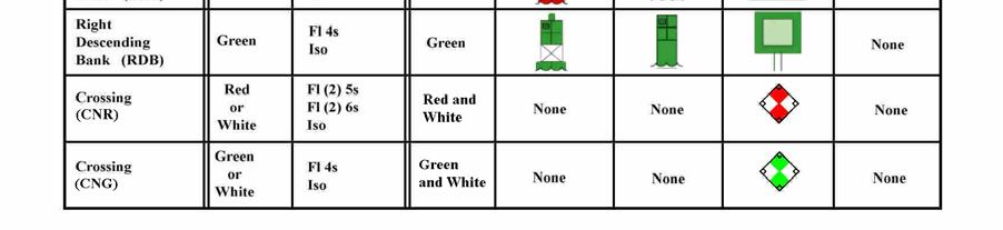

83 Figure


84 (1) Daymarks: The daymark is characterized by its color, shape, and number or letter. (a) Color: Since most of our aids are lateral marks, assigning the proper shape and color is usually clear. When looking in the direction of buoyage, aids to the right are red; those to the left are green. For those aids alongside two channels (junction, bifurcation, intersection), preferred channel marks are required. The higher priority channel dictates the dominant or uppermost color, while the lower priority channel dictates the auxiliary or lowermost color. Figure 4-6 shows an example of this application. Safewater marks are painted with red and white vertical stripes. Isolated Danger marks are black with a wide red, horizontal band. Special marks are yellow. Ranges can show any two of the colors red, green, black, white or yellow. Certain nonlateral aids, such as lighthouses, leading lights, crossing, or sector lights may carry NB, NG, or NR dayboards. Information daymarks are white with orange bands and orange geometric shapes. Figure
AAPSilver System Performance Validation
 Report No. CG-D-04-13 AAPSilver System Performance Validation Distribution Statement A: Approved for public release; distribution is unlimited. 1 N O T I C E This document is disseminated under the sponsorship
RESOLUTION MSC.278(85) (adopted on 1 December 2008) ADOPTION OF THE NEW MANDATORY SHIP REPORTING SYSTEM "OFF THE COAST OF PORTUGAL - COPREP"
 (adopted on 1 December 2008) ADOPTION OF THE NEW MANDATORY SHIP REPORTING SYSTEM OFF THE COAST OF PORTUGAL - COPREP") MSC 85/26/Add.1 RESOLUTION MSC.278(85) SYSTEM OFF THE COAST OF PORTUGAL COPREP THE MARITIME SAFETY COMMITTEE, RECALLING Article 28 of the Convention on the International Maritime Organization concerning
MSC 85/26/Add.1 RESOLUTION MSC.278(85) SYSTEM OFF THE COAST OF PORTUGAL COPREP THE MARITIME SAFETY COMMITTEE, RECALLING Article 28 of the Convention on the International Maritime Organization concerning
This document contained the major International agreements, plus United States radio laws and regulations, current at the time of publication.
 Do You Know? On June 27, 1914 the Department of Commerce published a new document called Regulations Governing Radio Operators And The Use Of Radio Apparatus On Ships And On Land. (http://earlyradiohistory.us/1914reg.htm#ra4-15)
NVIC Apr NAVIGATION AND VESSEL INSPECTION CIRCULAR NO Electronic Version for distribution via the World Wide Web
 Washington, D.C. 20593 (202) 426-4958 NVIC 7 86 30 Apr 1986 NAVIGATION AND VESSEL INSPECTION CIRCULAR NO. 7-86 Electronic Version for distribution via the World Wide Web Subj: Ref: Information on the Adequacy
MARITIME SAFETY INFORMATION
 Introduction 1. Maritime Safety Information (MSI) is defined as navigational and meteorological warnings, meteorological forecasts, and other urgent safety-related messages. This information is of vital
The Canadian Navigable Waters Act
 The Canadian Navigable Waters Act RESTORING LOST PROTECTIONS AND KEEPING CANADA S NAVIGABLE WATERS OPEN FOR PUBLIC USE FOR YEARS TO COME CANADA.CA/ENVIRONMENTALREVIEWS OVERVIEW 2 What we are doing In the
How to Conduct a Bridge to Bridge Inspection
 How to Conduct a Bridge to Bridge Inspection 80.1001 Applicability. The Bridge-to-Bridge Act and the regulations of this part apply to the following vessels in the navigable waters of the United States:
NUREG 0654, Federal Emergency Management Agency, establishes emergency notification requirements for Nuclear Power Plants.
 I. Introduction When the Emergency Broadcast System (EBS) was first introduced in the 1960s its scope was limited: warn the population of the threat of nuclear attack. Through the years, the EBS became
BookletChart. Sacramento River Andrus Island to Sacramento NOAA Chart A reduced-scale NOAA nautical chart for small boaters
 BookletChart Sacramento River Andrus Island to Sacramento NOAA Chart 18662 A reduced-scale NOAA nautical chart for small boaters When possible, use the full-size NOAA chart for navigation. Included Area
COMPLIANCE WITH THIS PUBLICATION IS MANDATORY
 BY ORDER OF THE COMMANDER MACDILL AIR FORCE BASE MACDILL AIR FORCE BASE INSTRUCTION 33-118 12 NOVEMBER 2013 COMMUNICATIONS AND INFORMATION ELECTROMAGNETIC SPECTRUM MANAGEMENT COMPLIANCE WITH THIS PUBLICATION
Fisheries and Marine Resources (Automatic Identification System) Regulations
 Regulations") Fisheries and Marine Resources (Automatic Identification System) Regulations 2016 GN No. 116 of 2016 Government Gazette of Mauritius No. 47of 28 May 2016 THE FISHERIES AND MARINE RESOURCES ACT Regulations
Fisheries and Marine Resources (Automatic Identification System) Regulations 2016 GN No. 116 of 2016 Government Gazette of Mauritius No. 47of 28 May 2016 THE FISHERIES AND MARINE RESOURCES ACT Regulations
BookletChart. Intracoastal Waterway Grassy Key to Bahia Honda Key NOAA Chart A reduced-scale NOAA nautical chart for small boaters
 BookletChart Intracoastal Waterway Grassy Key to Bahia Honda Key NOAA Chart 11453 A reduced-scale NOAA nautical chart for small boaters When possible, use the full-size NOAA chart for navigation. Published
PROVIDING KNOWLEDGE AND KNOWHOW... ANYTIME, ANYWHERE LIGHT LIST. Reference Materials. Digital Edition. Captain Robert L. Figular
 PROVIDING KNOWLEDGE AND KNOWHOW... ANYTIME, ANYWHERE LIGHT LIST Reference Materials Digital Edition Captain Robert L. Figular Page intentionally left blank LIGHT LIST Atlantic Coast of North America MLS
PAPUA NEW GUINEA HYDROGRAPHIC SERVICE
 PAPUA NEW GUINEA HYDROGRAPHIC SERVICE IHO SOUTH WEST PACIFIC HYDROGRAPHIC COMMISSION (SWPHC) 9 th Meeting Port Moresby, Papua New Guinea, 10-11 March 2007 SWPHC9-01PNG 1. INTRODUCTION 9 th SOUTH WEST PACIFIC
CLIENT ALERT. SBA Issues Several New Rulemakings, Including Proposed Increases to the Size Standards for NAICS Sectors 51 and 56.
 CLIENT ALERT SBA Issues Several New Rulemakings, Including Proposed Increases to the Size Standards for NAICS Sectors 51 and 56 October 17, 2011 SBA has been busy recently issuing several important rulemakings,
Distribution Restriction Statement Approved for public release; distribution is unlimited.
 CEMP-RA Engineer Regulation 200-1-1 Department of the Army U.S. Army Corps of Engineers Washington, DC 20314-1000 ER 200-1-1 30 May 2000 Environmental Quality POLICY AND GENERAL REQUIREMENTS FOR THE ENVIRONMENTAL
Rulemaking Hearing Rules of the Tennessee Department of Health Bureau of Health Licensure and Regulation Division of Emergency Medical Services
 Rulemaking Hearing Rules of the Tennessee Department of Health Bureau of Health Licensure and Regulation Division of Emergency Medical Services Chapter 1200-12-01 General Rules Amendments of Rules Subparagraph
RESOLUTION MSC.229(82) (adopted on 5 December 2006) ADOPTION OF A NEW MANDATORY SHIP REPORTING SYSTEM "IN THE GALAPAGOS PARTICULARLY SENSITIVE SEA
 (adopted on 5 December 2006) ADOPTION OF A NEW MANDATORY SHIP REPORTING SYSTEM IN THE GALAPAGOS PARTICULARLY SENSITIVE SEA") MSC 82/24/Add.2 RESOLUTION MSC.229(82) IN THE GALAPAGOS PARTICULARLY SENSITIVE SEA AREA (PSSA) (GALREP) THE MARITIME SAFETY COMMITTEE, RECALLING Article 28(b) of the Convention on the International Maritime
MSC 82/24/Add.2 RESOLUTION MSC.229(82) IN THE GALAPAGOS PARTICULARLY SENSITIVE SEA AREA (PSSA) (GALREP) THE MARITIME SAFETY COMMITTEE, RECALLING Article 28(b) of the Convention on the International Maritime
RESOLUTION MSC.230(82) (adopted on 5 December 2006) ADOPTION OF AMENDMENTS TO THE EXISTING MANDATORY SHIP REPORTING SYSTEM "IN THE STOREBÆLT (GREAT
 (adopted on 5 December 2006) ADOPTION OF AMENDMENTS TO THE EXISTING MANDATORY SHIP REPORTING SYSTEM IN THE STOREBÆLT (GREAT") MSC 82/24/Add.2 RESOLUTION MSC.230(82) MANDATORY SHIP REPORTING SYSTEM IN THE STOREBÆLT (GREAT BELT) TRAFFIC AREA THE MARITIME SAFETY COMMITTEE, RECALLING Article 28(b) of the Convention on the International
MSC 82/24/Add.2 RESOLUTION MSC.230(82) MANDATORY SHIP REPORTING SYSTEM IN THE STOREBÆLT (GREAT BELT) TRAFFIC AREA THE MARITIME SAFETY COMMITTEE, RECALLING Article 28(b) of the Convention on the International
THE USE OF A RADIO FREQUENCY SPECTRUM AND SATELLITE ORBIT (Government Regulation No. 53/2000 dated July 11, 2000)
") Considering: THE USE OF A RADIO FREQUENCY SPECTRUM AND SATELLITE ORBIT (Government Regulation No. 53/2000 dated July 11, 2000) THE PRESIDENT OF THE REPUBLIC OF INDONESIA That in the framework of implementing
Considering: THE USE OF A RADIO FREQUENCY SPECTRUM AND SATELLITE ORBIT (Government Regulation No. 53/2000 dated July 11, 2000) THE PRESIDENT OF THE REPUBLIC OF INDONESIA That in the framework of implementing
Section Meetings Section Material and Equipment. None Required
 January 2000 Page 1 of 8 PART 1 GENERAL 1.01 OTHER CONTRACT DOCUMENTS 1.02 DESCRIPTION OF WORK 1.03 RELATED WORK PART 2 PRODUCTS The General Conditions of the Contract, General Requirements and Supplemental
BookletChart. Chesapeake Bay Pocomoke and Tangier Sounds NOAA Chart A reduced-scale NOAA nautical chart for small boaters
 BookletChart Chesapeake Bay Pocomoke and Tangier Sounds NOAA Chart 12228 A reduced-scale NOAA nautical chart for small boaters When possible, use the full-size NOAA chart for navigation. Published by the
Fiscal 2007 Environmental Technology Verification Pilot Program Implementation Guidelines
 Fifth Edition Fiscal 2007 Environmental Technology Verification Pilot Program Implementation Guidelines April 2007 Ministry of the Environment, Japan First Edition: June 2003 Second Edition: May 2004 Third
UW REGULATION Patents and Copyrights
 UW REGULATION 3-641 Patents and Copyrights I. GENERAL INFORMATION The Vice President for Research and Economic Development is the University of Wyoming officer responsible for articulating policy and procedures
Guidance for Industry
 Guidance for Industry Formal Dispute Resolution: Scientific and Technical Issues Related to Pharmaceutical CGMP U.S. Department of Health and Human Services Food and Drug Administration Center for Drug
PRODUCTS AND SERVICES FOR THE MARITIME COMMUNITY. Ed Martin, Chief Customer Affairs Branch Navigation Services Division Monday, 27 October, 2008
 PRODUCTS AND SERVICES FOR THE MARITIME COMMUNITY Ed Martin, Chief Customer Affairs Branch Navigation Services Division Monday, 27 October, 2008 Coral Reef Conservation International Collaboration Marine
EL PASO COMMUNITY COLLEGE PROCEDURE
 For information, contact Institutional Effectiveness: (915) 831-6740 EL PASO COMMUNITY COLLEGE PROCEDURE 2.03.06.10 Intellectual Property APPROVED: March 10, 1988 REVISED: May 3, 2013 Year of last review:
LOUDON COUNTY ARES EMERGENCY OPERATIONS PLAN
 LOUDON COUNTY ARES EMERGENCY OPERATIONS PLAN MARCH 2008 I. INTRODUCTION A. Amateur Radio Service LOUDON COUNTY, TENNESSEE AMATEUR RADIO EMERGENCY SERVICE EMERGENCY OPERATIONS PLAN The Amateur Radio Service
TRAFFIC ENGINEERING DIVISION
 VIRGINIA DEPARTMENT OF TRANSPORTATION TRAFFIC ENGINEERING DIVISION MEMORANDUM GENERAL SUBJECT: Radio Systems/Highway Signs SPECIFIC SUBJECT: Use of Radio Systems by VDOT & Localities: HAR and TIS Informational
FRAMEWORK ACT ON MARINE FISHERY DEVELOPMENT. [Enforcement Date: Nov. 28, 2009] [Act No. 9717, May 27, 2009, Other Laws and Regulations Amended]
![FRAMEWORK ACT ON MARINE FISHERY DEVELOPMENT. [Enforcement Date: Nov. 28, 2009] [Act No. 9717, May 27, 2009, Other Laws and Regulations Amended]](/thumbs/90/103056266.jpg "FRAMEWORK ACT ON MARINE FISHERY DEVELOPMENT. [Enforcement Date: Nov. 28, 2009] [Act No. 9717, May 27, 2009, Other Laws and Regulations Amended]") The English version is translated and uploaded only for the purpose of no other than PR, and thereby, Framework Act on Marine Fishery Development in the Korean language will prevail regarding authorization
The English version is translated and uploaded only for the purpose of no other than PR, and thereby, Framework Act on Marine Fishery Development in the Korean language will prevail regarding authorization
FOR MORE INFORMATION ON GMDSS CONTACT:
 FOR MORE INFORMATION ON GMDSS CONTACT: Commanding Officer USCG Navigation Center, MS 7310, 7323 Telegraph Road, Alexandria, VA 20598-7310 Tel:1-703-313-5900 www.navcen.uscg.gov Commandant (CG-652) Spectrum
Policy on Patents (CA)
") RESEARCH Effective Date: Date Revised: N/A Supersedes: N/A Related Policies: Policy on Copyright (CA) Responsible Office/Department: Center for Research Innovation (CRI) Keywords: Patent, Intellectual
RESEARCH Effective Date: Date Revised: N/A Supersedes: N/A Related Policies: Policy on Copyright (CA) Responsible Office/Department: Center for Research Innovation (CRI) Keywords: Patent, Intellectual
SEI Certification Program Manual
 Safety Equipment Institute SEI Certification Program Manual Section 29: Industrial Protective Clothing and Equipment Program 0 of 6 SEI Certification Program Manual Section 29: Industrial Protective Clothing
Department of Operations Telecommunications Division
 COAST GUARD AUXILIARY HF TELECOMMUNICATIONS PROGRAM POLICIES AND PROCEDURES Section A. Auxiliary High Frequency (HF) Program A.1 Introduction: The Coast Guard Auxiliary High Frequency telecommunications
Radio Log Book. for Canadian Flag Vessels. 1 Master s Signature. Transports Canada. Transport Canada TP 13926E MARINE SAFETY
 Transport Canada MARINE SAFETY Transports Canada TP 13926E Radio Log Book for Canadian Flag Vessels Also for use on GMDSS exempted vessels Date Commenced Date Completed 1 Instructional Guide for Keeping
2 ESF 2 Communications
 2 ESF 2 Communications THIS PAGE LEFT BLANK INTENTIONALLY ESF 2 Communications Table of Contents 1 Purpose and Scope... ESF 2-1 2 Policies and Agreements... ESF 2-1 3 Situation and Assumptions... ESF 2-1
JEFFERSON LAB TECHNICAL ENGINEERING & DEVELOPMENT FACILITY (TEDF ONE) Newport News, Virginia
 Newport News, Virginia") BULLETIN NO. 6 TO THE PLANS AND SPECIFICATIONS FOR JEFFERSON LAB TECHNICAL ENGINEERING & DEVELOPMENT FACILITY (TEDF ONE) Newport News, Virginia EwingCole Architects.Engineers.Interior Designers.Planners
BULLETIN NO. 6 TO THE PLANS AND SPECIFICATIONS FOR JEFFERSON LAB TECHNICAL ENGINEERING & DEVELOPMENT FACILITY (TEDF ONE) Newport News, Virginia EwingCole Architects.Engineers.Interior Designers.Planners
IMO RESOLUTION A.1001(25) Adopted on 29 November 2007 (Agenda item 9)
 Adopted on 29 November 2007 (Agenda item 9)") INTERNATIONAL MARITIME ORGANIZATION E IMO ASSEMBLY 25th session Agenda item 9 A 25/Res.1001 3 January 2008 Original: ENGLISH RESOLUTION A.1001(25) Adopted on 29 November 2007 (Agenda item 9) CRITERIA FOR
INTERNATIONAL MARITIME ORGANIZATION E IMO ASSEMBLY 25th session Agenda item 9 A 25/Res.1001 3 January 2008 Original: ENGLISH RESOLUTION A.1001(25) Adopted on 29 November 2007 (Agenda item 9) CRITERIA FOR
ANTENNAS AND SATELLITE DISHES
 LAKE BARRINGTON COMMUNITY HOMEOWNERS ASSOCIATION 64 Old Barn Road Lake Barrington, Illinois 60010 Phone: 847-382-1660 Fax: 847-382-2731 HOMEOWNER APPLICATION FOR ARCHITECTURAL REVIEW ANTENNAS AND SATELLITE
AMENDMENTS TO RESOLUTION A.706(17) WORLD-WIDE NAVIGATIONAL WARNING SERVICE
 WORLD-WIDE NAVIGATIONAL WARNING SERVICE") E 4 ALBERT EMBANKMENT LONDON SE1 7SR Telephone: +44 (0)20 7735 7611 Fax: +44 (0)20 7587 3210 AMENDMENTS TO RESOLUTION A.706(17) WORLD-WIDE NAVIGATIONAL WARNING SERVICE MSC.1/Circ.1288/Rev.1 24 June 2013
E 4 ALBERT EMBANKMENT LONDON SE1 7SR Telephone: +44 (0)20 7735 7611 Fax: +44 (0)20 7587 3210 AMENDMENTS TO RESOLUTION A.706(17) WORLD-WIDE NAVIGATIONAL WARNING SERVICE MSC.1/Circ.1288/Rev.1 24 June 2013
THE HILLCREST VILLAGE HOMEOWNERS ASSOCIATION, INC. RULES FOR INSTALLATION OF ANTENNAS
 THE HILLCREST VILLAGE HOMEOWNERS ASSOCIATION, INC. RULES FOR INSTALLATION OF ANTENNAS I. Preamble These rules are adopted by the Board of Directors of The Hillcrest Village Homeowners Association, Inc.,
BookletChart. Sacramento River Sacramento to Fourmile Bend NOAA Chart A reduced-scale NOAA nautical chart for small boaters
 BookletChart Sacramento River Sacramento to Fourmile Bend NOAA Chart 18664 A reduced-scale NOAA nautical chart for small boaters When possible, use the full-size NOAA chart for navigation. Included Area
United States Coast Guard Office of Navigation Systems
 United States Coast Guard Office of Navigation Systems Future of Navigation Initiatives & Operations R. David Lewald Program Analyst Navigation Systems Office of Navigation Systems U.S. Coast Guard Washington,
II. Statutory and Regulatory Authorities for Underground Coal Mines
 I. Purposes MEMORANDUM OF UNDERSTANDING BETWEEN THE U.S. DEPARTMENT OF LABOR, MINE SAFETY AND HEALTH ADMINISTRATION AND THE U.S. DEPARTMENT OF THE INTERIOR, BUREAU OF LAND MANAGEMENT The purposes of this
SATELLITE NETWORK NOTIFICATION AND COORDINATION REGULATIONS 2007 BR 94/2007
 BR 94/2007 TELECOMMUNICATIONS ACT 1986 1986 : 35 SATELLITE NETWORK NOTIFICATION AND COORDINATION ARRANGEMENT OF REGULATIONS 1 Citation 2 Interpretation 3 Purpose 4 Requirement for licence 5 Submission
SECTION IV - DISCREPANCIES
 SECTION IV - DISCREPANCIES INTRODUCTION: An important aspect of the Auxiliary ATON/CU Program includes the methods and procedures for informing the proper Government agencies of findings. An Auxiliary
Licence Application Submission Procedure for Planned Radio Stations Below 960 MHz
 Issue 5 October 2008 Spectrum Management and Telecommunications Radio Standards Procedure Licence Application Submission Procedure for Planned Radio Stations Below 960 MHz Aussi disponible en français
California State University, Northridge Policy Statement on Inventions and Patents
 Approved by Research and Grants Committee April 20, 2001 Recommended for Adoption by Faculty Senate Executive Committee May 17, 2001 Revised to incorporate friendly amendments from Faculty Senate, September
Pickens Savings and Loan Association, F.A. Online Banking Agreement
 Pickens Savings and Loan Association, F.A. Online Banking Agreement INTERNET BANKING TERMS AND CONDITIONS AGREEMENT This Agreement describes your rights and obligations as a user of the Online Banking
Oklahoma State University Policy and Procedures
 Oklahoma State University Policy and Procedures THE OKLAHOMA STATE UNIVERSITY MUSEUM 1-0119 GENERAL UNIVERSITY SEPTEMBER 1, 1977 GENERAL POLICY l.0l The Museum exists to facilitate and enhance the teaching,
GUIDELINES FOR THE APPLICATION FOR A SPACE STATION CARRIER LICENCE. Section 1 - Introduction
 GUIDELINES FOR THE APPLICATION FOR A SPACE STATION CARRIER LICENCE Section 1 - Introduction 1.1 Pursuant to section 7(5) of the Telecommunications Ordinance (hereinafter the Ordinance ), the Communications
GENERAL DESCRIPTION OF THE CMC SERVICES
 STANDARD FOR CERTIFICATION No.1.1 GENERAL DESCRIPTION OF THE CMC SERVICES MAY 2007 FOREWORD (DNV) is an autonomous and independent foundation with the objectives of safeguarding life, property and the
DNVGL-CP-0338 Edition October 2015
 CLASS PROGRAMME DNVGL-CP-0338 Edition October 2015 The electronic pdf version of this document, available free of charge from http://www.dnvgl.com, is the officially binding version. FOREWORD DNV GL class
G17 Dam Safety Processes
 TITLE: G17 Dam Safety Processes VERSION NO: Final 1.4 RESPONSIBILITY: Manager Consents DATE ISSUED: July 2016 G17 Dam Safety Processes Contents 1. INTRODUCTION... 1 2. SITUATIONS OF IMMEDIATE DANGER...
SHARED TENANT SERVICE (STS) ARRANGEMENTS
 ARRANGEMENTS") Southwestern Bell Telephone 2nd Revised Sheet 1 Company d/b/a AT&T Missouri Replacing 1st Revised Sheet 1 37.1 Definition of Service 37.1.1 Shared Tenant Service (STS) Arrangements are the provision of
Southwestern Bell Telephone 2nd Revised Sheet 1 Company d/b/a AT&T Missouri Replacing 1st Revised Sheet 1 37.1 Definition of Service 37.1.1 Shared Tenant Service (STS) Arrangements are the provision of
IHO Colours & Symbols Maintenance Working Group (C&SMWG) 15th Meeting, BSH, Rostock, Germany, 2-4 May 2005
 15th Meeting, BSH, Rostock, Germany, 2-4 May 2005") CSMWG15-INF2 IHO Colours & Symbols Maintenance Working Group (C&SMWG) 15th Meeting, BSH, Rostock, Germany, 2-4 May 2005 Ref: HA405/004/033-01 NOTE: this is an internal document of the UKHO and is supplied
CSMWG15-INF2 IHO Colours & Symbols Maintenance Working Group (C&SMWG) 15th Meeting, BSH, Rostock, Germany, 2-4 May 2005 Ref: HA405/004/033-01 NOTE: this is an internal document of the UKHO and is supplied
BookletChart. St. Joseph and Benton Harbor NOAA Chart A reduced-scale NOAA nautical chart for small boaters
 BookletChart St. Joseph and Benton Harbor NOAA Chart 14930 A reduced-scale NOAA nautical chart for small boaters When possible, use the full-size NOAA chart for navigation. Included Area Published by the
Aboriginal Consultation and Environmental Assessment Handout CEAA November 2014
 Introduction The Government of Canada consults with Aboriginal peoples for a variety of reasons, including: statutory and contractual obligations, policy and good governance, building effective relationships
Unit 2: Understanding NIMS
 Unit 2: Understanding NIMS This page intentionally left blank. Objectives At the end of this unit, you should be able to describe: The intent of NIMS. Key concepts and principles underlying NIMS. Scope
CHAPTER 11 PRELIMINARY SITE PLAN APPROVAL PROCESS
 CHAPTER 11 PRELIMINARY SITE PLAN APPROVAL PROCESS 11.01.00 Preliminary Site Plan Approval 11.01.01 Intent and Purpose 11.01.02 Review 11.01.03 Application 11.01.04 Development Site to be Unified 11.01.05
Technical Requirements for Land Mobile and Fixed Radio Services Operating in the Bands / MHz and / MHz
 Issue 5 November 2013 Spectrum Management and Telecommunications Standard Radio System Plan Technical Requirements for Land Mobile and Fixed Radio Services Operating in the Bands 806-821/851-866 MHz and
ECDIS ENC Accuracy. Contents. Introduction LOSS PREVENTION BRIEFING FOR NORTH MEMBER SHIPS / MAY Introduction... 1
 LOSS PREVENTION BRIEFING FOR NORTH MEMBER SHIPS / MAY 2017 ECDIS ENC Accuracy Contents Introduction... 1 ECDIS Specific Familiarisation... 2 IHO S-57... 2 ENC Data Source... 2 CATZOC and M_QUAL... 2 CATZOC
Dissemination of enhanced Marine Safety Information (emsi) via AIS: Requirements for an AIS transmit service
 via AIS: Requirements for an AIS transmit service") Dissemination of enhanced Marine Safety Information (emsi) via AIS: Requirements for an AIS transmit service Brian Tetreault Navigation Systems Specialist US Army Corps of Engineers Engineer Research &
Dissemination of enhanced Marine Safety Information (emsi) via AIS: Requirements for an AIS transmit service Brian Tetreault Navigation Systems Specialist US Army Corps of Engineers Engineer Research &
This circular summarizes the various important aspects of the LRIT system with a view to enabling companies to ensure compliance in a timely manner.
 Luxembourg, 29/10/2008 CIRCULAR CAM 02/2008 N/Réf. : AH/63353 Subject : Long-Range Identification and Tracking of Ships (LRIT) To : All ship owners, ship operators and designated persons of Luxembourg
MEMORANDUM NO MAY Directives Affected. Reference (a) is temporarily augmented by this policy letter.
 is temporarily augmented by this policy letter.") U.S. Department of Commandant 2100 Second Street, S.W. Homeland Security United States Coast Guard Washington, DC 20593-0001 Staff Symbol: -1 Phone: (202) 267-2735 United States Fax: (202) 267-4394 Coast
U.S. Department of Commandant 2100 Second Street, S.W. Homeland Security United States Coast Guard Washington, DC 20593-0001 Staff Symbol: -1 Phone: (202) 267-2735 United States Fax: (202) 267-4394 Coast
Drawbridge Operation Regulation; Oakland Inner Harbor, ACTION: Notice of deviation from drawbridge regulation.
 This document is scheduled to be published in the Federal Register on 03/06/2015 and available online at http://federalregister.gov/a/2015-05231, and on FDsys.gov 9110-04-P DEPARTMENT OF HOMELAND SECURITY
Protection of Privacy Policy
 Protection of Privacy Policy Policy No. CIMS 006 Version No. 1.0 City Clerk's Office An Information Management Policy Subject: Protection of Privacy Policy Keywords: Information management, privacy, breach,
DEPARTMENT OF DEFENSE HANDBOOK STANDARD MICROCIRCUIT DRAWINGS
 NOT MEASUREMENT SENSITIVE MIL-HDBK-780D 28 May 2004 SUPERSEDING MIL-HDBK-780C 15 August 1997 DEPARTMENT OF DEFENSE HANDBOOK STANDARD MICROCIRCUIT DRAWINGS This handbook is for guidance only. Do not cite
IALA Guideline No. XXXX. The establishment of AIS as an Aid to Navigation. Edition 1.3. [Date] Working vs / Working 7.
![IALA Guideline No. XXXX. The establishment of AIS as an Aid to Navigation. Edition 1.3. [Date] Working vs / Working 7.](/thumbs/74/71399138.jpg "IALA Guideline No. XXXX. The establishment of AIS as an Aid to Navigation. Edition 1.3. [Date] Working vs / Working 7.") ANM12/Output/10 International Association of Marine Aids to Navigation and Lighthouse Authorities AISM Association of Internationale de Signalisation Maritime IALA IALA Guideline No. XXXX On The establishment
ANM12/Output/10 International Association of Marine Aids to Navigation and Lighthouse Authorities AISM Association of Internationale de Signalisation Maritime IALA IALA Guideline No. XXXX On The establishment
SECTION EMERGENCY RESPONDER RADIO COVERAGE SYSTEMS
 510.1 Emergency responder radio coverage in new buildings. Approved radio coverage for emergency responders shall be provided within all buildings meeting any one of the following conditions: 1. There
SECTION SHOP DRAWINGS, PRODUCT DATA, AND SAMPLES
 SECTION 01 33 23 SHOP DRAWINGS, PRODUCT DATA, AND SAMPLES PART 1 GENERAL 1.1 DESCRIPTION A. This specification defines the general requirements and procedures for submittals. A submittal is information
SECTION SUBMITTAL PROCEDURES
 SECTION 01330 - SUBMITTAL PROCEDURES PART 1 - GENERAL 1.1 RELATED DOCUMENTS A. Drawings and general provisions of the Contract, including General and Supplementary Conditions and other Division 1 Specification
PUBLIC ART PROCUREMENT GUIDELINES
 PUBLIC ART PROCUREMENT GUIDELINES A. Preliminary A. In 1983, the Minnesota State Legislature enacted the law forming the basis for the Minnesota Percent for Art in Public Places program. This legislation
Route Planning & Cable Route Surveys
 Route Planning & Cable Route Surveys Graham Evans Director EGS Survey Group www.egssurvey.com Concept to Reality Key Phases Development of Business Model Definition of Key Project Milestones Project Concept
SAINT VINCENT AND THE GRENADINES TELECOMMUNICATIONS (SPECTRUM MANAGEMENT) REGULATIONS 2007 ARRANGEMENT OF REGULATIONS PART I PRELIMINARY PART II
 REGULATIONS 2007 ARRANGEMENT OF REGULATIONS PART I PRELIMINARY PART II") SAINT VINCENT AND THE GRENADINES Regulation TELECOMMUNICATIONS (SPECTRUM MANAGEMENT) REGULATIONS 2007 ARRANGEMENT OF REGULATIONS 1. Citation 2. Interpretation and Application PART I PRELIMINARY PART II
SAINT VINCENT AND THE GRENADINES Regulation TELECOMMUNICATIONS (SPECTRUM MANAGEMENT) REGULATIONS 2007 ARRANGEMENT OF REGULATIONS 1. Citation 2. Interpretation and Application PART I PRELIMINARY PART II
ROUTEING OF SHIPS, SHIP REPORTING AND RELATED MATTERS. Establishment of a Mandatory Ship Reporting System in the
 INTERNATIONAL MARITIME ORGANIZATION E SUB-COMMITTEE ON SAFETY OF NAVIGATION 48th session Agenda item 3 IMO NAV 48/3/2 11 April 2002 Original: ENGLISH ROUTEING OF SHIPS, SHIP REPORTING AND RELATED MATTERS
LIFE SAFETY DIVISION GUIDELINE. Subject: BDA Radio Amplification Checklist Date initiated: Date revised:
 Castle Rock Fire and Rescue Department LIFE SAFETY DIVISION GUIDELINE Subject: BDA Radio Amplification Checklist Date initiated: 02-1-2016 Date revised: Approved: CRFD Richard Auston, Division Chief of
State Archives of Florida Collection Development Policy
 State Archives of Florida Collection Development Policy January 2010 Table of Contents Introduction... 2 State Archives of Florida Mission and Programs... 3 Mission... 3 Organization... 3 Collections...
RADIO AMATEUR CIVIL EMERGENCY SERVICE (RACES) POLICIES/PROCEDURES AND OPERATIONS MANUAL CITY OF HOUSTON
 POLICIES/PROCEDURES AND OPERATIONS MANUAL CITY OF HOUSTON") RADIO AMATEUR CIVIL EMERGENCY SERVICE (RACES) POLICIES/PROCEDURES AND OPERATIONS MANUAL CITY OF HOUSTON ii APPROVAL AND IMPLEMENTATION RADIO AMATEUR CIVIL EMERGENCY SERVICE (RACES) Craig A. McDowell Emergency
RADIO AMATEUR CIVIL EMERGENCY SERVICE (RACES) POLICIES/PROCEDURES AND OPERATIONS MANUAL CITY OF HOUSTON ii APPROVAL AND IMPLEMENTATION RADIO AMATEUR CIVIL EMERGENCY SERVICE (RACES) Craig A. McDowell Emergency
SECTION SHOP DRAWINGS, PRODUCT DATA, AND SAMPLES
 SECTION 01334 SHOP DRAWINGS, PRODUCT DATA, AND SAMPLES PART 1 GENERAL 1.01 SUMMARY A. Submit to the ENGINEER for review, such working drawings, shop drawings, test reports and data on materials and equipment
DEPARTMENT OF DEFENSE HANDBOOK STANDARD MICROCIRCUIT DRAWINGS
 NOT MEASUREMENT SENSITIVE w/change 2 28 March 2017 SUPERSEDING w/change 1 6 January 2012 DEPARTMENT OF DEFENSE HANDBOOK STANDARD MICROCIRCUIT DRAWINGS This handbook is for guidance only. Do not cite this
UNITED STATES DEPARTMENT OF THE INTERIOR BUREAU OF LAND MANAGEMENT WASHINGTON, D.C October 23, 2003
 UNITED STATES DEPARTMENT OF THE INTERIOR BUREAU OF LAND MANAGEMENT WASHINGTON, D.C. 20240 October 23, 2003 EMS TRANSMISSION 10/23/2003 Instruction Memorandum No. 2003-275 Change 1 Expires: 09/30/2004 In
PUERTO RICO TELEPHONE COMPANY, INC. Second Revision - Page K-1-1 Canceling First Revision - Page K-1-1. ADDITIONAL SERVICES TARIFF SCHEDULE (Cont.
 Second Revision - Page K-1-1 Canceling First Revision - Page K-1-1 25.1 Applicability TO THE PUBLIC TELEPHONE NETWORK This tariff applies to the Basic Interconnection Services provided by the Company,
MUSEUM SERVICE ACT I. BASIC PROVISIONS
 Pursuant to Article 82, paragraph 1, item 2 and Article 91, paragraph 1, of the Constitution of Montenegro, the 24 th Convocation of the Assembly of Montenegro, at its 10 th session of the first regular
The Future in Marine Radio Communication GMDSS. Department of Transportation United States Coast Guard
 The Future in Marine Radio Communication GMDSS Department of Transportation United States Coast Guard Do you use a Maritime Radio System? If so, the new Global Maritime Distress and Safety System (GMDSS)
TCC/SHORE TRANSIT BUS MAINTENANCE FACILITY - PHASE II
 SECTION 013300 - SUBMITTAL PROCEDURES PART 1 - GENERAL 1.1 RELATED DOCUMENTS A. Drawings and general provisions of the Contract, including General and Supplementary Conditions and other Division 01 Specification
Jacksonville District Master
 -01 33 00 (April 2006) From USACE / NAVFAC / AFCESA UFGS UNIFIED FACILITIES GUIDE SPECIFICATIONS Revised thoughout - changes not indicated by CHG tags SECTION TABLE OF CONTENTS DIVISION 01 - GENERAL REQUIREMENTS
DNVGL-CG-0214 Edition September 2016
 CLASS GUIDELINE DNVGL-CG-0214 Edition September 2016 The content of this service document is the subject of intellectual property rights reserved by ("DNV GL"). The user accepts that it is prohibited by
Procedure VHF Communication VTS and HCC Port of Rotterdam Authority Harbour Master's Division
 Procedure VHF Communication VTS and HCC Port of Rotterdam Authority Harbour Master's Division Author: B. Röhner Date: Contents 1. PROCEDURE VHF COMMUNICATION VESSEL TRAFFIC SERVICES (VTS)... 1 2. Area
A Bill Regular Session, 2017 HOUSE BILL 1926
 Stricken language would be deleted from and underlined language would be added to present law. 0 0 0 State of Arkansas st General Assembly As Engrossed: H// A Bill Regular Session, 0 HOUSE BILL By: Representative
Loyola University Maryland Provisional Policies and Procedures for Intellectual Property, Copyrights, and Patents
 Loyola University Maryland Provisional Policies and Procedures for Intellectual Property, Copyrights, and Patents Approved by Loyola Conference on May 2, 2006 Introduction In the course of fulfilling the
Engineering Drawing System
 LPR 7320.1 Effective Date: February 2, 2010 Expiration Date: February 2, 2015 Langley Research Center Engineering Drawing System National Aeronautics and Space Administration Responsible Office: Systems
DEPARTMENT OF TRANSPORTATION
 DEPARTMENT OF TRANSPORTATION Federal Aviation Administration 14 CFR Part 39 [61 FR 625 No. 6; 01/09/96][SN] [Docket No. 94-ANE-63; Amendment 39-9458; AD 95-03-10] Textron Lycoming AD 95-03-10 Amendment
Incentive Guidelines. Aid for Research and Development Projects (Tax Credit)
") Incentive Guidelines Aid for Research and Development Projects (Tax Credit) Issue Date: 8 th June 2017 Version: 1 http://support.maltaenterprise.com 2 Contents 1. Introduction 2 Definitions 3. Incentive
Incentive Guidelines Aid for Research and Development Projects (Tax Credit) Issue Date: 8 th June 2017 Version: 1 http://support.maltaenterprise.com 2 Contents 1. Introduction 2 Definitions 3. Incentive
GUIDANCE FOR THE PRESENTATION AND DISPLAY OF AIS APPLICATION-SPECIFIC MESSAGES INFORMATION
 E 4 ALBERT EMBANKMENT LONDON SE1 7SR Telephone: +44 (0)20 7735 7611 Fax: +44 (0)20 7587 3210 Ref. T2-OSS/2.7.1 SN.1/Circ.290 2 June 2010 GUIDANCE FOR THE PRESENTATION AND DISPLAY OF AIS APPLICATION-SPECIFIC
Charter of the Regional Technical Forum Policy Advisory Committee
 Phil Rockefeller Chair Washington Tom Karier Washington Henry Lorenzen Oregon Bill Bradbury Oregon W. Bill Booth Vice Chair Idaho James Yost Idaho Pat Smith Montana Jennifer Anders Montana Charter of the
SUMMARY: The Coast Guard is declaring Sea Area A1 in certain. areas off the coast of the United States based upon the
 DEPARTMENT OF HOMELAND SECURITY Coast Guard [Docket No. USCG-2015-0002] Declaration of Sea Area A1 ACTION: Notice. This document is scheduled to be published in the Federal Register on 01/20/2015 and available
SECTION DEWATERING TANKAGE PART 1 - GENERAL 1.1 RELATED DOCUMENTS
 SECTION 31 23 19 - DEWATERING TANKAGE PART 1 - GENERAL 1.1 RELATED DOCUMENTS A. Drawings and general provisions of the Contract, including General and Supplementary Conditions and Division 1 Specification
Deepwater Archaeology and Cultural Resource Management: Working with
 Deepwater Archaeology and Cultural Resource Management: Working with Industry to Protect our Heritage Marine Technology Society Conference September 29, 2004 Houston, Texas MMS Jack B. Irion, Ph.D. Minerals
Taylor County July 2011 SECTION SHOP DRAWINGS, WORKING DRAWINGS AND SAMPLES
 SECTION 01340 SHOP DRAWINGS, WORKING DRAWINGS AND SAMPLES PART 1 - GENERAL 1.1 REQUIREMENTS INCLUDED A. Contractor shall submit to the Architect/Engineer for review and exception, if any, such working