Planning Commission Agenda Report Meeting Date 6/07/18
|
|
|
- Barrie Booth
- 5 years ago
- Views:
Transcription
 Use Permit 17-21 (MT2 Telecom Tower) 945 West 2 nd Street, APN 004-037-003 (portion) SUMMARY This is a request to construct and operate a 105-foot tall mono-pine multi-carrier telecommunications")
1 Planning Commission Agenda Report Meeting Date 6/07/18 DATE: May 18, 2018 Files: UP TO: FROM: RE: PLANNING COMMISSION Shannon Costa, Assistant Planner ( , Use Permit (MT2 Telecom Tower) 945 West 2 nd Street, APN (portion) SUMMARY This is a request to construct and operate a 105-foot tall mono-pine multi-carrier telecommunications tower, including associated ground-mounted equipment located at 945 West 2 nd Street, on the westerly portion of the block between West 2 nd Street, West 3 rd Street, Cedar Street and the Union Pacific Railroad. All ground-mounted equipment would be installed within a fenced area and landscaping provided around the exterior of the site. Radio frequency (RF) exposure from the new antenna array would be less than the allowable Federal standard. Because the tower site is within 1000-feet of an existing telecommunications facility (Cal Water Tank), a use permit is required. The existing Cal-Water tank has been determined to be seismically deficient, and could be decommissioned and dismantled. The applicant proposes to construct a new facility to avoid a lapse in coverage should the tank come down. The property is designated Industrial Office Mixed Use on the City of Chico General Plan diagram, and is located in a IOMU-FS (Industrial Office Mixed Use with Fraternity and Sorority overlay) zoning district. This project is categorically exempt from further environmental review pursuant to Section of the California Environmental Quality Act Guidelines (New Construction or Conversion of Small Structures). Recommendation: Planning staff recommends that the Planning Commission adopt Resolution No (Attachment A) approving Use Permit Proposed Motion: I move that the Planning Commission adopt Resolution No , approving Use Permit (MT2 Telecom), based on the required findings and subject to the conditions contained therein. BACKGROUND The applicant, Riverview Management Group and MT2 Telecom, is a requesting to construct and operate a 105-foot tall mono-pine multi-carrier telecommunications tower and associated groundmounted equipment. The site is located at 945 West 2 nd Street, on the westerly portion of the block between West 2 nd Street, West 3 rd Street, Cedar Street and the Union Pacific Railroad (see
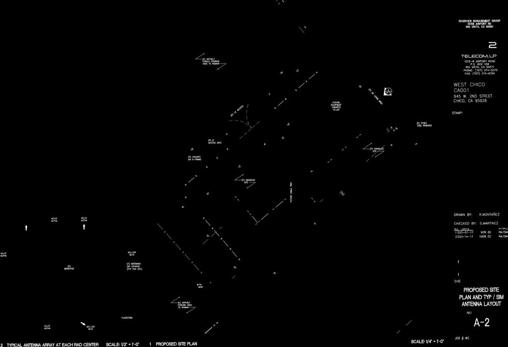
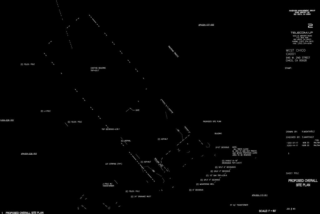
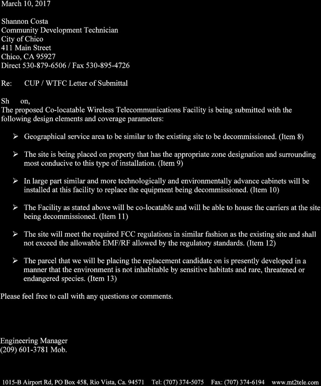
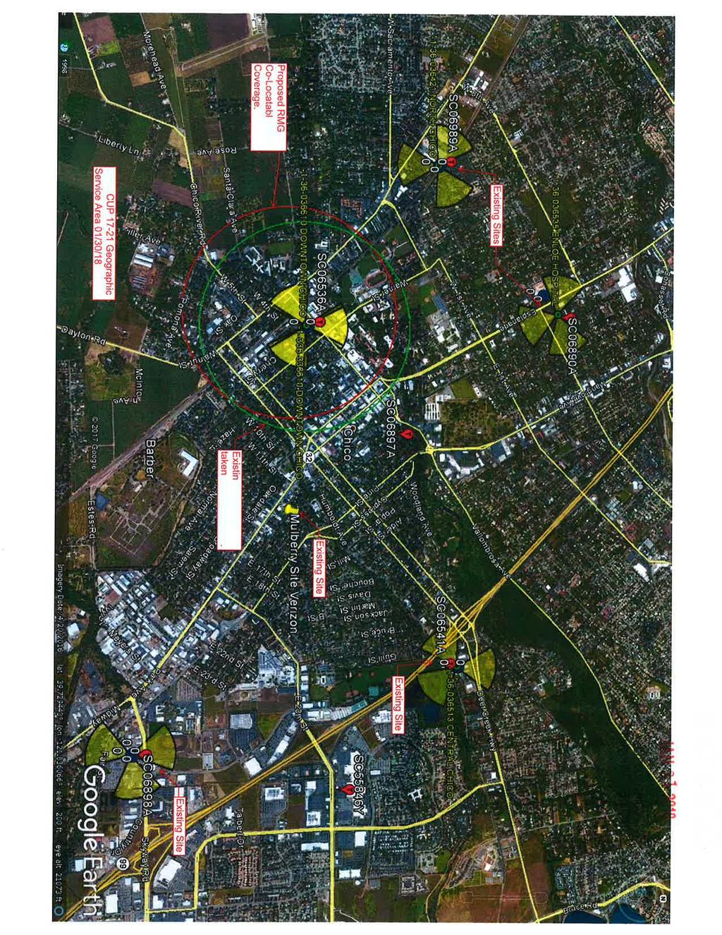
2 MT2 Telecom (UP 17-21) PC Mtg. 06/03/18 Page 2 of 8 Location Map, Attachment B, and Aerial Photo, Attachment C). The 0.5-acre site is designated Industrial Office Mixed Use on the City of Chico General Plan Land Use Diagram and is zoned IOMU-FS (Industrial Office Mixed Use with Fraternity and Sorority overlay). The site would remain under the ownership of Ronald White, and a 1,500-square foot portion of the site would be leased to the applicant for the telecommunications facility. Surrounding land uses include commercial and residential uses to the west, a recreational park to the south, a parking lot to the east and a vacant lot to the north. The property is partially developed with a commercial storage building and associated parking. The project consists of the construction of an unmanned 105-foot mono-pine telecommunications tower and associated ground-mounted equipment on the southerly 1,500 square foot portion of the property (see Plat to Accompany Use Permit 17-21, Attachment D). DISCUSSION Pursuant to CMC , new telecommunications towers are allowed in the IOMU zoning district subject to the issuance of a wireless telecommunications facilities permit if all the development standards are met. If one or more of the standards cannot be met, a use permit is required. The proposed tower is subject to issuance of a use permit because there is an existing tower located within 1,000 feet. The existing tower is a California Water Service (Cal Water) storage tank located approximately 500-feet easterly from the project site. As described in the applicant s letter of submittal, (Attachment E), the new tower is necessary to avoid a lapse in coverage for the surrounding service area currently served by the existing Cal Water tank tower, should it be decommissioned. The existing Cal Water tank tower currently houses several antennas owned by a variety of wireless carries. Cal Water recently determined that the tank does not meet current earthquake standards and informed the wireless carriers that the tank would eventually be decommissioned and dismantled. No application for demolition has been received by the City Building Department as of the date of this report. Pursuant to CMC B.2 (Application Requirements) the applicant has acknowledged that the new tower would be co-locatable for other wireless carriers to mount antennas and equipment upon (see Attachment E, Letter of Submittal). As required by the City s Wireless Telecommunications Facility (WTF) regulations (CMC 19.78), this application was reviewed by Sherry Miller, the City s Airport Manager. She determined that the proposed facility does not encroach into navigable airspace as defined by part 77 of Title 14 of the Code of Federal Regulations (which begins at 200 feet above ground level when not in the immediate vicinity of an airport). Therefore, special painting or lighting for aircraft identification is not required, and is specifically prohibited (pursuant to CMC A.2) to minimize visual impacts. Tower Location and Design The applicant has sited the proposed tower on the southerly portion of a partially developed commercial site. The proposed tower would be located approximately 500-feet from the existing Cal Water tank tower located on the northwest corner of Cherry Street and West 3 rd Street. The site was selected by the applicant because of its proximity to the existing water tank tower, and that the landowner was willing to enter into a lease agreement. A geographical service area map (see Attachment F, Service Area Map) provided by the applicant indicates that the new tower
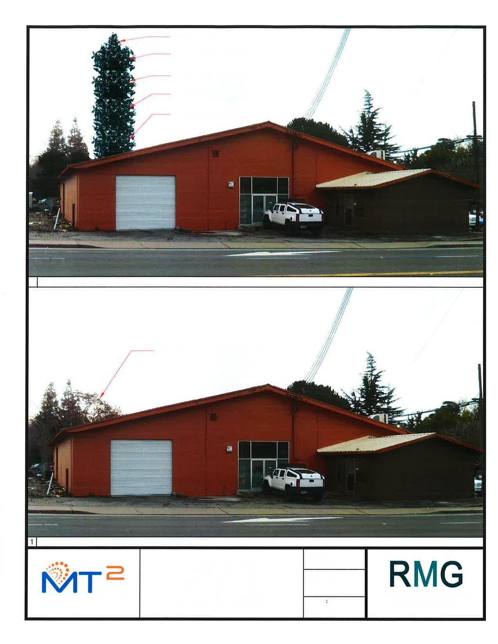
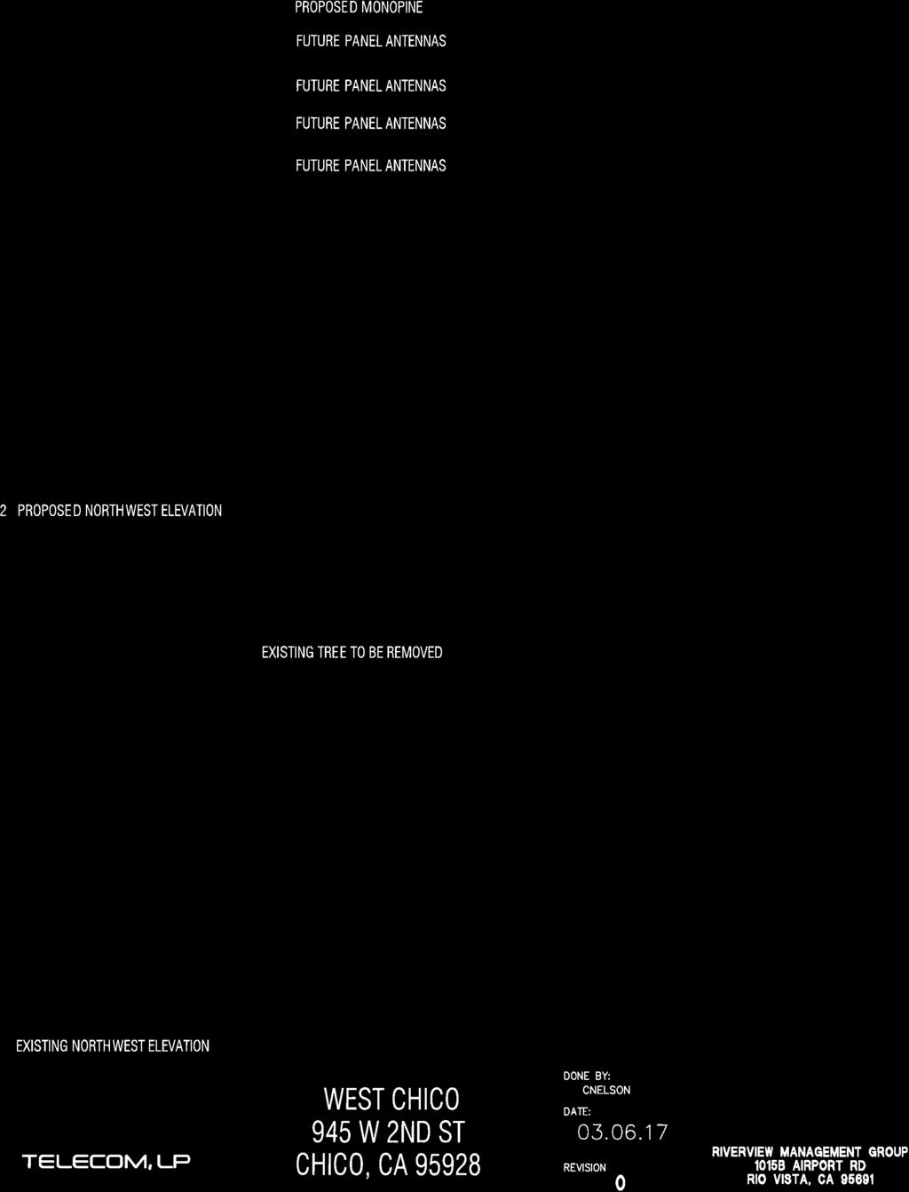
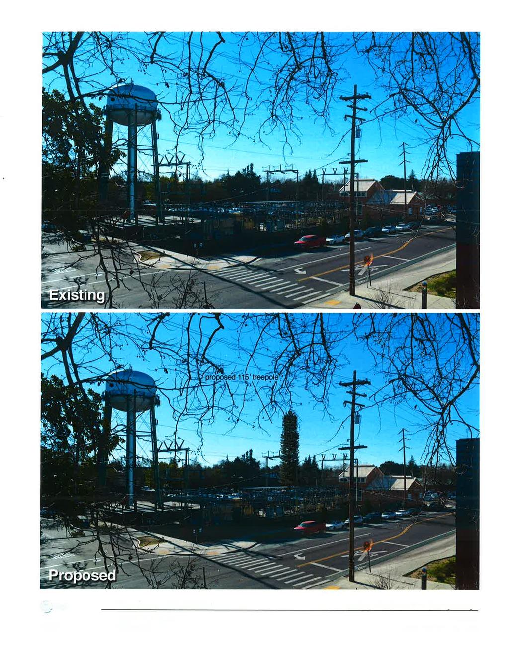
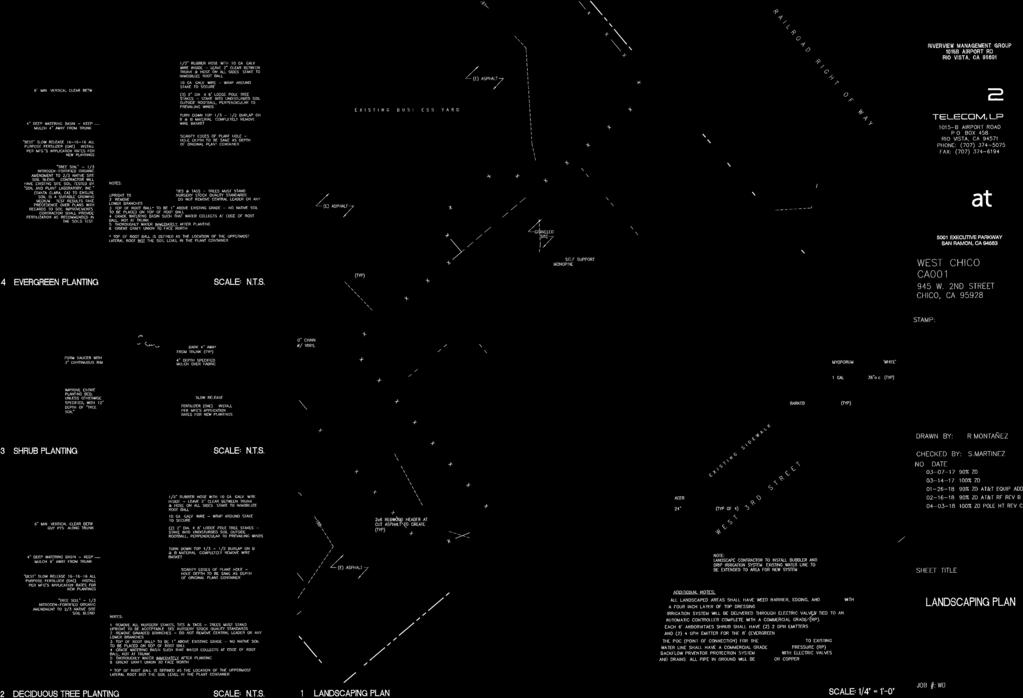
3 MT2 Telecom (UP 17-21) PC Mtg. 06/07/18 Page 3 of 8 would cover nearly the same service area as the existing water tank tower, which is currently the only tower currently serving this portion of town. This location in conjunction with the proposed height of 105-feet tall would provide equal wireless coverage to this service area, should the water tank tower be decommissioned. The proposed mono-pine is a stealth design commonly used in urban areas. This type of tower has the visual appearance of a pine tree while screening antenna panels within tree branches (see Attachment G, Elevations). The tower antennas, or working portion reach 100-feet in height with an additional five-feet of tree branches (105-feet total) and is 21-feet shorter than the existing Cal Water tank tower that reaches 126-feet in height (see Attachment H, Tank Elevations). The visual simulations provided by the applicant assist in depicting the proposed mono-pine WTF and the existing water tank tower in the background (see Attachment I, Visual Simulation). While the mono-pine WTF is clearly visible, its tree-like appearance helps it blend in to the background. A chain-link fence with vinyl slats and barbed-wire is proposed around the perimeter of the site. Barbed-wire is prohibited, pursuant to CMC (Fencing and screening) unless authorized through use permit approval. The applicant did not wish to pursue a request for barbed-wire along with this use permit, so a condition of approval has been included (condition of approval #3) that precludes the use of barbed-wire and limits the fence height to six-feet in height in compliance with CMC The site plan indicates that all trees located within the project area would be removed. The location of seven existing deciduous trees and their measurement at breast height diameter (DBH) are listed, but no species name is provided. At least four trees measure greater than 6 inches at DBH and could qualify for mitigation pursuant to the City s Tree Preservation Regulations (CMC 16.66). A condition of approval is included (condition of approval #5) that would require the applicant to mitigate for any tree removal, pursuant to CMC Various shrubs would be planted around the perimeter of the project side that would provide additional screening of ground-mounted equipment (see Attachment J, Planting Plan). Ground Mounted Equipment and Noise All equipment associated with the project including ground-mounted equipment cabinets, generators, back up radio batteries and air-conditioning units are located within a fenced area that includes a chain-link fence with vinyl slats and a buffer of shrubs and trees. The shelter housing the ground-mounted equipment will be fitted with an air conditioner to keep the electronic equipment at required operating temperatures. According to the manufacturers data, the noise generated by the proposed air conditioner is approximately 55.9 db at 30-feet and 49.7 dba at a distance of 50-feet (see Attachment K, AC Acoustical Information), which is well below the City s allowable noise threshold for commercial uses of 70 dba, pursuant to CMC (Noise). The nearest residential use to the proposed tower is located approximately 100-feet southwesterly of the site and staff has no concerns with noise generated by the air conditioner associated with the project.
4 MT2 Telecom (UP 17-21) PC Mtg. 06/07/18 Page 4 of 8 Radio Frequency (RF) Emissions Exposure to radio frequency (RF) emissions, also known as electromagnetic field (EMF) emissions, is associated with the operation of Wireless Telecommunications Facilities (WTFs). RF emissions from WTFs are regulated by the Federal Communications Commission (FCC), pursuant to the Telecommunications Act of 1996 (TCA). Existing City regulations require an analysis by a qualified RF engineer showing that the cumulative emissions of all proposed facilities comply with FCC standards concerning RF emissions. Information regarding measuring human exposure to radiofrequency energy can be found in Attachment L (Safety and Interference Potential at Wireless Communications Sites). The standards established by the FCC are based on recommendations from the Environmental Protection Agency, Food and Drug Administration, Occupational Health and Safety Act of 1970 and the National Institute for Occupational Safety and Health, and are set at a level many times lower than that which may pose a health risk. In this case, the required radio frequency emissions compliance report prepared by Waterford Consultants, LLC for AT&T mobility, (see Attachment M, RF Report) shows that for accessible areas at ground level, the maximum predicated power density levels and cumulative power density levels resulting from all AT&T mobility operations is significantly less than the FCC General Population limits (1.64% of 100% exposure limit). The project complies with the standard by a wide margin. Waterford Consultants, LLC recommends posting RF alerting signage with contact information at the base of the proposed mono-pine to inform authorized climbers of potential conditions near the antennas. As such, a condition of approval has been included to require this signage. With the exception of being located within 1000 feet of an existing telecommunications facility, the tower would comply with all City standards for new towers (Attachment N, Development Standards). The primary purpose of the project is to provide a new tower for wireless carriers to co-locate their antennas, and to avoid a lapse in coverage should the Cal Water tank tower be decommissioned, but no new service would be provided as a result of the new tower. As such, it is not legally necessary to approve this project to comply with the requirements of the TCA. However, the project will result in continued and uninterrupted signal coverage in this portion of Chico. GENERAL PLAN The Industrial Office Mixed Use General Plan designation for the site is intended for a wide range and combination of light industrial and office development with commercial and other support services integrated vertically and horizontally. The following General Plan goals, policies and programs should be considered when reviewing this project: Policy ED-1.6 (Enhanced Wireless Telecommunication) Encourage the provision of wireless telecommunications services throughout the urban area at a level greater than the minimum required by the Telecommunications Act for improved business development, access to information, and public safety. Policy LU-2.4 (Land Use Compatibility) Promote land use compatibility through use restrictions, development standards, environmental review and special design considerations.
5 MT2 Telecom (UP 17-21) PC Mtg. 06/07/18 Page 5 of 8 Policy LU-4.4 (Positive Contributions) Encourage infill development that provides missing neighborhood elements, such as neighborhood retail, enhance architectural quality, and circulation improvements for pedestrians, bicycles and vehicles, or that otherwise contributes positively to existing neighborhoods. Action S (Emergency Response Awareness) - Promote community preparedness for hazards and awareness of emergency notification methods. ENVIRONMENTAL REVIEW This project is categorically exempt from further environmental review pursuant to Section of the California Environmental Quality Act Guidelines (New Construction or Conversion of Small Structures) based on this project's size and scope, its proximity to a nearby tower site which is proposed to be removed, and the lack of unusual circumstance evidencing a significant effect on the environment. The project consists of new construction less than 2,500 square feet in floor area on an existing developed property in an urban area zoned for the use, does not involve significant amounts of hazardous substances, all necessary public facilities and services are available, and the surrounding area is not environmentally sensitive. FINDINGS Following a public hearing, the Planning Commission may approve a use permit application, with or without conditions, only if all of the following findings can be made: Use Permit Findings 1. The proposed use is allowed within the subject zoning district and complies with all of the applicable provisions of Chapter (Use Permits). Construction of a new wireless telecommunications facility which does not meet all development standards, (i.e, a minimum 500-foot distance between elementary and secondary schools and residential zones, all new towers shall be unlit unless otherwise required by the FAA and new towers shall generally not be permitted within 1,000 feet of an existing telecommunications tower) is allowed in the IOMU zoning district, subject to issuance of a use permit. This permit has been processed in accordance with Chapters (Use Permits) and (Wireless Telecommunications Facilities). 2. The proposed use would not be detrimental to the health, safety, and general welfare of persons residing or working in the neighborhood of the proposed use. The radio frequency emissions compliance report prepared by Waterford Consultants, LLC for AT&T mobility shows that for accessible areas at ground level, the maximum predicated power density levels and cumulative power density levels resulting from all AT&T mobility operations is significantly less than the FCC General Population limits (1.64% of 100% exposure limit). The project complies with the standard by a wide margin. The project will not result in any significant noise impacts. The proposed tower would provide an overall benefit to the community and those residing or working in the neighborhood because its presence would avoid a lapse in wireless coverage should the existing tower be decommissioned. No
6 MT2 Telecom (UP 17-21) PC Mtg. 06/07/18 Page 6 of 8 other impacts have been identified that would be detrimental to persons residing or working in the area. 3. The proposed use would not be detrimental and/or injurious to property and improvements in the neighborhood of the proposed use, as well as the general welfare of the City. The project will comply with all applicable building and improvement regulations and standards. The unstaffed facility would not generate vehicle traffic other than during installation and periodic maintenance. Access to the site is provided by an existing driveway located on W. 2 nd Street and would not require additional public improvements. The project will not cause any damage or otherwise be injurious to property or improvements in the neighborhood, and will not be detrimental to the general welfare of the City. 4. The proposed entitlement is consistent with the General Plan, any applicable specific plan, and any applicable neighborhood or area plan. Industrial Office Mixed Use General Plan Designation allows a variety of uses, including telecommunications facilities. The proposed tower would provide continued and uninterrupted wireless service to users in the service area and avoid a possible lapse in coverage should the existing tower be decommissioned. Wireless service availability implements General Plan goals and policies that encourage public safety notification methods. 5. The design, location, size, and operating characteristics of the proposed use are compatible with the existing and future land uses in the vicinity. The proposed design complies with CMC Section 19.78, which governs wireless telecommunications facilities. The ground lease area represents a very small portion of the property, and will be compatible with existing and future uses of the facility. As required by CMC 19.78, the tower would be available for other wireless carriers to co-locate their equipment upon, minimizing the overall number of towers in the area. With its mono-pine design, the project will be moderately camouflaged to resemble a tree and blend into and recede into the background of the urban tree canopy. Additional findings for WTF Use Permit: 1. The facility to be permitted will not generate EMF/RF radiation in excess of the FCC adopted standards for human exposure. The radio frequency emissions compliance report prepared by Waterford Consultants, LLC for AT&T mobility shows that for accessible areas at ground level, the maximum predicated power density levels and cumulative power density levels resulting from all AT&T mobility operations is significantly less than the FCC General Population limits. The project therefore complies with the standard by a wide margin. 2. If the height of the facility exceeds the standards set forth in Section , that the facility has been designed to minimize its height and other visual effects.
7 MT2 Telecom (UP 17-21) PC Mtg. 06/07/18 Page 7 of 8 CMC states if the telecommunications tower is more than 100 feet in height, it must be designed at the minimum height functionally required. The overall height of the tower is 105-feet tall, however, the functional height of the tower is 100-feet tall, as antennas are mounted at mounted on the tower at 67-feet, 77-feet, 87-feet, and 97-feet high The additional 5-feet in height is to provide for the top-most point of the tree and is decorative in nature. The tower has been designed at a height similar to the Cal Water tank tower to match existing coverage for the service area. 3. The facility does not encroach into navigable airspace as defined by Part 77 of Title 14 of the Code of Federal Regulations. As required by the City s Wireless Telecommunications Facility (WTF) regulations, this application was reviewed by Sherry Miller, the City s Airport Manager. She determined that the proposed facility does not encroach into navigable airspace as defined by part 77 of Title 14 of the Code of Federal Regulations (which begins at 200 feet above ground level when not in the immediate vicinity of an airport). Therefore, special painting or lighting for aircraft identification is not required, and is specifically prohibited (pursuant to CMC A.2) to minimize visual impacts. Additional findings for new telecommunications facility tower which is proposed to be located within 1,000 feet of an existing tower: 1. The cumulative visual impacts are not significant. Ground-mounted equipment would be properly screened from view through a combination of fencing with vinyl slats and a heavy landscape buffer around the perimeter of the project site. The visual simulations provided by the applicant assist in depicting the proposed monopine WTF and the existing water tank tower in the background (see Attachment I, Visual Simulation). While the mono-pine WTF is clearly visible, its tree-like appearance helps it blend in to the background. 2. Location within 1,000 feet of the existing tower is technically necessary to provide services not possible with co-location on an existing tower or structure in the service area. Cal Water recently determined that the water tank that currently houses several antennas owned by multiple wireless carriers and provides wireless service to the area, does not meet current earthquake standards and informed the wireless carriers that the tank would eventually be decommissioned and dismantled. The proposed tower is necessary in order to provide continued and uninterrupted wireless service to the surrounding service area. PUBLIC CONTACT A 10-day public hearing notice was mailed to all landowners and residents within 1,000 feet of the site. A legal notice was also placed in the Chico Enterprise Record. As of the date of this report, no additional inquiries regarding this project had been received by City staff. DISTRIBUTION: PC Distribution
8 MT2 Telecom (UP 17-21) PC Mtg. 06/07/18 Page 8 of 8 Riverview Management Group/MT2 Telecom c/o Salomon Martinez Jr., 1015B Airport Road, Rio Vista, CA AP Costa ATTACHMENTS: A. Resolution No Exhibit I - Conditions of Approval B. Location Map C. Aerial Photo D. Plat to Accompany Use Permit (2) E. Letter of Submittal F. Service Area Map G. Elevations H. Tank Elevations I. Visual Simulations (3) J. Planting Plan K. AC Unit Acoustical Information L. Safety and Interference Potential at Wireless Communications Sites M. RF Report N. Excerpt of CMC A., Development Standards for New Telecommunications Towers
9 RESOLUTION NO RESOLUTION OF THE CITY OF CHICO PLANNING COMMISSION APPROVING USE PERMIT (MT2 Telecom) WHEREAS, applications have been received for a use permit to construct and operate a 105- foot mono-pine multi-carrier telecommunications tower, including associate ground-mounted equipment located at 945 West 2 nd Street, on the westerly portion of the block between West 2 nd Street, West 3 rd Street, Cedar Street and the Union Pacific Railroad, further identified as Assessor s Parcel No , (the Project ); and WHEREAS, Mr. Ronald White, the owner of the property, and lease a 1,500-square foot portion of the site to the applicant, Riverview Management Group and MT2 Telecom, for the use and operation of the telecommunications facility; WHEREAS, the Planning Commission considered the Project, and staff report at a noticed public hearing held on June 7, 2018; and WHEREAS, the Project has been determined to be exempt pursuant to California Environmental Quality Act Guidelines (Section New Construction or Conversion of Small Structures) based on this project's size and scope, its proximity to a nearby tower site which is proposed to be removed, and the lack of unusual circumstance evidencing a significant effect on the environment; NOW, THEREFORE, BE IT RESOLVED by the Planning Commission of the City of Chico as follows: 1. With regard to the use permit Planning Commission finds that: A. Construction of a new telecommunications tower which does not meet all development standards is allowed in the IOMU zoning district, subject to issuance of a use permit. This permit has been processed in accordance with Chapters (Use Permits) and (Wireless Telecommunications Facilities). B. The project complies with Federal Communications Commission s radio frequency emission standards by a wide margin. The project will not result in any significant noise impacts. The proposed tower would provide an overall benefit to the community and those Attachment A Page 1 of 4
10 residing or working in the neighborhood because its presence would avoid a lapse in wireless coverage should the existing tower be decommissioned. No other impacts have been identified that would be detrimental to persons residing or working in the area. C. The project will comply with all applicable building and improvement regulations and standards. The unstaffed facility would not generate vehicle traffic other than during installation and periodic maintenance. Access to the site is provided by an existing driveway located on W. 2 nd Street and would not require additional public improvements. The project will not cause any damage or otherwise be injurious to property or improvements in the neighborhood, and will not be detrimental to the general welfare of the City. D. Industrial Office Mixed Use General Plan Designation allows a variety of uses, including telecommunications facilities. The proposed tower would provide continued and uninterrupted wireless service to users in the service area and avoid a possible lapse in coverage should the existing tower be decommissioned. Wireless service availability implements General Plan goals and policies that encourage public safety notification and communication. E. The proposed design complies with CMC Section 19.78, which governs wireless telecommunications facilities. The ground lease area represents a very small portion of the property, and will be compatible with existing and future uses of the facility. As required by CMC 19.78, the tower would be available for other wireless carriers to co-locate their equipment upon, minimizing the overall number of towers in the area. With its mono-pine design, the project will be moderately camouflaged to resemble a tree and blend into and recede into the background of the urban tree canopy. 2. With regard to additional findings for Wireless Telecommunications Facility Use Permit, the Planning Commission finds that: A. The radio frequency emissions compliance report shows that for accessible areas at ground level, the maximum predicated power density levels and cumulative power density levels resulting from all AT&T mobility operations is significantly less than the FCC General Population limits. The project therefore complies with the standard by a wide margin. Attachment A Page 2 of 4
11 B. The overall height of the tower is 105-feet tall, however, the functional height of the tower is 100-feet tall. The additional 5-feet in height is to provide for the top-most point of the tree and is decorative in nature. The tower has been designed at a height similar to the Cal Water tank tower to match existing coverage for the service area. C. As required by the City s Wireless Telecommunications Facility (WTF) regulations, this application was reviewed by Sherry Miller, the City s Airport Manager. She determined that the proposed facility does not encroach into navigable airspace as defined by part 77 of Title 14 of the Code of Federal Regulations (which begins at 200 feet above ground level when not in the immediate vicinity of an airport). Therefore, special painting or lighting for aircraft identification is not required, and is prohibited (pursuant to CMC A.2) to minimize visual impacts. 3. With regard to additional findings for a new telecommunications facility which is proposes to be located with 1,000 feet of an existing tower, the Planning Commission finds that; A. Ground-mounted equipment would be properly screened from view through a combination of fencing with vinyl slats and a heavy landscape buffer around the perimeter of the project site. Visual simulations provided by the applicant assist in depicting the proposed monopine WTF and the existing water tank tower in the background; while the mono-pine WTF is clearly visible, its tree-like appearance helps it blend in to the background. B. Cal Water recently determined that the water tank that currently houses several antennas owned by multiple wireless carriers and provides wireless service to the area, does not meet current earthquake standards and informed the wireless carriers that the tank would eventually be decommissioned and dismantled. The proposed tower is necessary in order to provide continued and uninterrupted wireless service to the surrounding service area. 4. Based on all of the above, the Planning Commission hereby approves the Project subject to the conditions set forth in Exhibit I attached hereto. 5. The Planning Commission hereby specifies that the materials and documents which constitute the record of proceedings upon which its decision is based are located at and under the custody of the City of Chico Community Development Department. Attachment A Page 3 of 4
12 THE FOREGOING RESOLUTION WAS ADOPTED by the Planning Commission at its meeting held on June 7, 2018, by the following vote: AYES: NOES: ABSENT: ABSTAINED: DISQUALIFIED: ATTEST: APPROVED AS TO FORM: Brendan Vieg Planning Commission Secretary Andrew L. Jared, Assistant City Attorney* *Pursuant to the Charter of the City of Chico, Section 906(E) Attachment A Page 4 of 4
13 EXHIBIT I CONDITIONS OF APPROVAL New Wireless Telecommunications Facility Tower MT2 Telecom (UP 17-21) 1. Use Permit authorizes the construction and operation of a 105-foot tall mono-pine multi-carrier telecommunications tower, including associated ground-mounted equipment located at 945 West 2 nd, in substantial accord with the Site Plan to Accompany Use Permit (MT2 Telecom) and in compliance with all other conditions of approval. 2. The permittee shall comply with all other State and local Code provisions, including those of the Building Division, Public Works Department, Fire Department, and Butte County Environmental Health. The permittee is responsible for contacting these offices to verify the need for permits. 3. All fencing and screening of the site shall be in compliance with CMC (Fencing and Screening). The minimum fence height shall be no greater than six-feet tall and razor/barbed wire is prohibited. 4. The applicant shall post Radio Frequency (RF) alerting signage with contact information at the base of the proposed mono-pine to inform authorized climbers of potential conditions near the antennas. 5. As required by CMC 16.66, trees removed shall be replaced as follows: a. On-site. For every six inches in DBH removed, a new 15-gallon tree shall be planted on-site. Replacement trees shall be of similar species, unless otherwise approved by the urban forest manager, and shall be placed in areas dedicated for tree plantings. New plantings survival shall be ensured for three years after the date of planting and shall be verified by the applicant upon request by the director. If any replacement trees die or fail within the first three years of their planting, then the applicant shall pay an in-lieu fee as established by a fee schedule adopted by the City Council. b. Off-site. If it is not feasible or desirable to plant replacement trees on-site, payment of an in-lieu fee as established by a fee schedule adopted by the City Council shall be required. c. Replacement trees shall not receive credit as satisfying shade or street tree requirements otherwise mandated by the municipal code. d. Tree removal shall be subject to the in-lieu fee payment requirements set forth by Chico Municipal Code (CMC) and fee schedule adopted by the City Council. e. All trees not approved for removal shall be preserved on and adjacent to the project site. A tree preservation plan, including fencing around drip lines and methods for excavation within the drip lines of protected trees to be preserved shall be prepared by the project developer pursuant to CMC and for review and approval by planning staff prior to any ground-disturbing activities. Exhibit I
 PROJECT SITE W 3RD ST ORANGE ST NEWMAN CENTER CALWATER CHERRY ST Attachment B HICKORY ST ASH ST 0 250 Feet W 4TH ST UP 17-21 (MT2 Telecom Tower) 945 W 2nd Street APN 004-037-003-000 DEPOT")
14 OAK ST IVY ST CSUC CAMPUS HAZEL ST PG&E NOTRE DAME ES BIG CHICO CR OAK PARK AVE (ST HWY 32) RIO CHICO WAY CHICO CREEK DANCE NORD AVE ROSEDALE ES W 1ST ST BURGER KING UPRR W 2ND ST 7 ELEVEN WALNUT ST (ST HWY 32) PROJECT SITE W 3RD ST ORANGE ST NEWMAN CENTER CALWATER CHERRY ST Attachment B HICKORY ST ASH ST Feet W 4TH ST UP (MT2 Telecom Tower) 945 W 2nd Street APN DEPOT PARK W 5TH ST CHICO ARTS CENTER RILEY'S

15 Attachment C CSUC Rec Center Project Site Cal Water Tank
16 Attachment D
17 Attachment D

18 Attachment E
19 Attachment F
20 Attachment G
21 Attachment H


22 Attachment I
23 Attachment I
24 Attachment I
25 Attachment J
26 Attachment K
27 2 0 1 L o u d o u n S t r e e t S E S u i te 300 L e e s b u r g, V A O f f i c e F a x w a te r f o r dc o n su l t a n ts. c o m Safety and Interference Potential at Wireless Communications Sites Service providers build new communication sites in order to address customer need for coverage and capacity offered by wireless networks. Sites consist of radio equipment that is located at ground level or mounted near antennas and are designed to provide service to specific areas in the community. Common concerns relating to the siting of tower sites is the potential impact on human health as well as interference to existing services and near-by electrical devices. Potential for Hazardous Exposure to Radiofrequency Energy The Federal Communications Commission (FCC) requires licensees to ensure that new and existing wireless operations do not expose people to hazardous levels of radio frequency (RF) electromagnetic energy. Service providers consider compliance with these rules when designing new sites or modifying existing operations that could change the RF environment. These FCC rules are based on exposure limits established by scientific and engineering organizations that review human health research in this field. At RF frequencies, the electromagnetic waves utilized by cellular sites represent non-ionizing radiation which can be absorbed by the human body. The FCC limits include a 50-fold safety factor above exposure levels where adverse thermal effects may result. By contrast, the energy available in ionizing radiation (e.g. X-rays) is higher and has the ability to permanently damage tissue cells at the molecular level. Unlike ionizing radiation, exposure to non-ionizing radiation does not have cumulative effects and the FCC limits are based on the body s thermoregulation capabilities. The FCC radiofrequency radiation exposure compliance requirements are set forth in 47 C.F.R (b) and The limits are defined by maximum Specific Absorption Rate (SAR) values of the human body for two tiers of permissible exposure differentiated by the situation in which the exposure takes place and/or the status of the individuals who are subject to exposure. The first tier, General Population / Uncontrolled, exposure limits apply to those situations in which persons may not be aware of the presence of electromagnetic energy, where exposure is not employment-related, or where persons cannot exercise control over their exposure. The second tier, Occupational / Controlled, exposure limits apply to situations in which persons are exposed as a consequence of their employment, have been made fully aware of the potential for exposure, and can exercise control over their exposure. Based on these criteria, the FCC limits for the General Population are associated with continuous exposure conditions and exposure levels below these limits are not hazardous. As a practical method of evaluating compliance in deployment scenarios, the FCC has set forth Maximum Permissible Exposure (MPE) limits which are derived from the whole-body SAR limits. Specified in terms of electric field strength, magnetic field strength and equivalent plane-wave power density, compliance may be evaluated through computational or measurement methods provided in the FCC Office of Engineering & Technology (OET) Bulletin 65, Evaluating Compliance with FCC Guidelines for Human Exposure to Radiofrequency Electromagnetic Fields (OET-65). Factors that determine exposure conditions include frequency, operating power, distance and directivity of the antenna. Cellular operators utilize these guidelines to design communications sites that maintain safe environmental conditions. Compliance involves consideration of the cumulative contributions of all wireless operations. The power density resulting from an RF source may be expressed as a percentage of the frequency-specific FCC limits. In scenarios involving multiple RF emitters, the percentage of the FCC limits from each source are summed to determine if 100% of the exposure limit has been exceeded at a given location. An evaluation of existing environmental conditions may be performed through predictive modeling as set forth in OET-65 or collecting broadband measurements. The impact of new or modified wireless operations must be assessed in this cumulative scenario and any area that is accessible to members of the General Population must be compliant. Attachment L

28 2 0 1 L o u d o u n S t r e e t S E Su i t e 300 L e e s b u r g, V A O f f i c e F a x w a te r f o r dc o n su l t a n ts. c o m At wireless sites, antennas may support transmit or receive operations. Receive antennas and other tower appurtenances are not sources of RF emissions. RF energy decreases significantly with distance from any antenna. The panel-type antennas typically employed at a site are highly directional by design and emissions below and behind the antenna are 1000x less than emissions in front. The antenna directivity serves to reduce the potential to exceed MPE limits at any location other than directly in front of the antennas. When antennas are mounted on monopole, lattice or guyed towers, this directivity and the mounting height result in RF exposure conditions at ground-level that are well below the FCC General Population limits (typically less than 2% MPE) even when multiple wireless service providers share a tower. Additional information is available at the following link: Potential for Interference to Electronic Devices The technical equipment to be installed by wireless service providers represents the state of the art and has been carefully designed to preclude the possibility of interference to other services and home/business equipment, including the transmission and reception of broadcast AM, FM, and Television services. Interference may occur when a device receives unwanted energy from a nearby source. Wireless service provider equipment designs meet or exceed all FCC emission requirements to suppress RF energy outside of the allocated band of frequencies. As radio signals and electrical noise are always present, any electronic equipment should be designed to minimize susceptibility to this energy while performing its function. Some cases of interference to cable television signals from cellular signals have been reported. In this scenario, the operating frequencies of the broadcast channel within the cable and wireless systems were similar (700 MHz) and involved mobile phones in close proximity to the cable box or low-quality cable. Phones may be actively exchanging signaling or application data between voice conversations. While it is possible that a similar pathway exists for wireless base station signals to enter the cable system, this scenario is far less likely due to the lower signal power present within the home. Cellular equipment is designed to prevent interference with other wireless communications services, such as police, fire, utility and other public safety and public service facilities as well as private communications installations, such as cordless telephones, and Citizen s Band and Radio Amateur stations. Site designs involve consideration of antenna placement near existing antennas to ensure sufficient isolation is available between systems to accommodate frequency plans and avoid interference. In summary, the design of equipment to be installed at a communications site and consideration of existing nearby radio operations serves to minimize the potential for interference to these systems or residential electrical devices :43:28-04'00' Attachment L

29 Radio Frequency Emissions Compliance Report For AT&T Mobility Site Name: Cal Water Chico Relo Site Structure Type: Monopine Address: 945 West Second Street Latitude: Chico, CA Longitude: Report Date: April 28, 2018 Project: New Build General Summary AT&T Mobility has contracted Waterford Consultants, LLC to conduct a Radio Frequency Electromagnetic Compliance assessment of the proposed Cal Water Chico Relo site located at 945 West Second Street, Chico, CA. This report contains information about the radio telecommunications equipment to be installed at this site and the surrounding environment with regard to RF Hazard compliance. This assessment is based on installation designs and operational parameters provided by AT&T Mobility. The compliance framework is derived from the Federal Communications Commission (FCC) Rules and Regulations for preventing human exposure in excess of the applicable Maximum Permissible Exposure ( MPE ) limits. At any location at this site, the power density resulting from each transmitter may be expressed as a percentage of the frequency-specific limits and added to determine if 100% of the exposure limit has been exceeded. The FCC Rules define two tiers of permissible exposure differentiated by the situation in which the exposure takes place and/or the status of the individuals who are subject to exposure. General Population / Uncontrolled exposure limits apply to those situations in which persons may not be aware of the presence of electromagnetic energy, where exposure is not employment-related, or where persons cannot exercise control over their exposure. Occupational / Controlled exposure limits apply to situations in which persons are exposed as a consequence of their employment, have been made fully aware of the potential for exposure, and can exercise control over their exposure. Based on the criteria for these classifications, the FCC General Population limit is considered to be a level that is safe for continuous exposure time. The FCC General Population limit is 5 times more restrictive than the Occupational limits. Frequency (MHz) Limits for General Population/ Uncontrolled Exposure Power Density Averaging Time (mw/cm 2 ) (minutes) Limits for Occupational/ Controlled Exposure Power Density Averaging Time (mw/cm 2 ) (minutes) f/ f/ , f=frequency (MHz) In situations where the predicted MPE exceeds the General Population threshold in an accessible area as a result of emissions from multiple transmitters, FCC licensees that contribute greater than 5% of the aggregate MPE share responsibility for mitigation. Page 1 Waterford Consultants, LLC 201 Loudoun Street Southeast Suite 300 Leesburg, Virginia Attachment M
30 Cal Water Chico Relo -New Site Build Based on the computational guidelines set forth in FCC OET Bulletin 65, Waterford Consultants, LLC has developed software to predict the overall Maximum Permissible Exposure possible at any particular location given the spatial orientation and operating parameters of multiple RF sources. These theoretical results represent worst-case predictions as emitters are assumed to be operating at 100% duty cycle. For any area in excess of 100% General Population MPE, access controls with appropriate RF alerting signage must be put in place and maintained to restrict access to authorized personnel. Signage must be posted to be visible upon approach from any direction to provide notification of potential conditions within these areas. Subject to other site security requirements, occupational personnel should be trained in RF safety and equipped with personal protective equipment (e.g. RF personal monitor) designed for safe work in the vicinity of RF emitters. Controls such as physical barriers to entry imposed by locked doors, hatches and ladders or other access control mechanisms may be supplemented by alarms that alert the individual and notify site management of a breach in access control. Waterford Consultants, LLC recommends that any work activity in these designated areas or in front of any transmitting antennas be coordinated with all wireless tenants. Analysis AT&T Mobility proposes the following installation at this location: Install (6) antennas at 97 rad center Install (6) antennas at 87 rad center The antennas will be mounted on a proposed 105-foot monopine with centerlines at 97 feet and 87 feet above ground level. The antennas will be oriented toward 0, 120 and 240 degrees. The Effective Radiated Power (ERP) in any direction from all AT&T Mobility operations will not exceed 46,754 Watts. Other appurtenances such as GPS antennas, RRUs and hybrid cable are not sources of RF emissions. From this site, AT&T Mobility will enhance voice and data services to surrounding areas in licensed 700, 850, 1900, 2100 and 2300 MHz bands. Panel antennas have been installed on a nearby water tanks by other wireless operators. Assumed operating parameters for these antennas are listed in Appendix A. Power density decreases significantly with distance from any antenna. The panel-type antennas to be employed at this site are highly directional by design and the orientation in azimuth and mounting elevation, as documented, serve to reduce the potential to exceed MPE limits at any location other than directly in front of the antennas. For accessible areas at ground level, the maximum predicted power density level resulting from all AT&T Mobility operations is 1.64% of the FCC General Population limits. Based on the operating parameters in Appendix A, the cumulative power density level at this location from all antennas is 2.03% of the FCC General Population limits. Incident at adjacent buildings depicted in Figure 1, the maximum predicted power density level resulting from all AT&T Mobility operations is 2.71% of the FCC General Population limits. Based on the operating parameters in Appendix A, the cumulative power density level at this location from all antennas is 3.10% of the FCC General Population limits. The proposed operation will not expose members of the General Public to hazardous levels of RF energy and will not contribute to existing cumulative MPE levels on walkable surfaces at ground or at adjacent buildings by 5% of the General Population limits. Waterford Consultants, LLC recommends posting RF alerting signage with contact information (Caution 2) at the base of the proposed monopine to inform authorized climbers of potential conditions near the antennas. These recommendations are depicted in Figure 2. Page 2 Waterford Consultants, LLC 201 Loudoun Street Southeast Suite 300 Leesburg, Virginia Attachment M

31 Cal Water Chico Relo -New Site Build Figure 1: Antenna Locations Page 3 Waterford Consultants, LLC 201 Loudoun Street Southeast Suite 300 Leesburg, Virginia Attachment M

32 Cal Water Chico Relo -New Site Build Figure 2: Mitigation Recommendations Compliance Statement Based on information provided by AT&T Mobility, predictive modeling and the mitigation to be implemented by AT&T Mobility, the installation proposed by AT&T Mobility at 945 West Second Street, Chico, CA will be compliant with Radiofrequency Radiation Exposure Limits of 47 C.F.R (b)(3) and RF alerting signage and restricting access to the monopine to authorized climbers that have completed RF safety training is required for Occupational environment compliance. Certification I, David H. Kiser, am the reviewer and approver of this report and am fully aware of and familiar with the Rules and Regulations of both the Federal Communications Commissions (FCC) and the Occupational Safety and Health Administration (OSHA) with regard to Human Exposure to Radio Frequency Radiation, specifically in accordance with FCC s OET Bulletin 65. I have reviewed this Radio Frequency Exposure Assessment report and believe it to be both true and accurate to the best of my knowledge. Page 4 Waterford Consultants, LLC 201 Loudoun Street Southeast Suite 300 Leesburg, Virginia Attachment M
33 Cal Water Chico Relo -New Site Build Appendix A: Assumed Parameters for Antennas Installed at Water Tank by Other Operators Ant Num Name Freq (MHz) ERP (W) Type Rad Center (ft AGL) Gain (dbd) Orientation (Deg) Horizontal Beam Width (Deg) 17 T-Mobile PANEL 00DT T-Mobile PANEL 00DT T-Mobile PANEL 00DT T-Mobile PANEL 00DT T-Mobile PANEL 00DT T-Mobile PANEL 00DT T-Mobile PANEL 00DT T-Mobile PANEL 00DT T-Mobile PANEL 00DT T-Mobile PANEL 00DT T-Mobile PANEL 00DT T-Mobile PANEL 00DT Verizon PANEL 00DT Verizon PANEL 00DT Verizon PANEL 00DT Verizon PANEL 00DT Verizon PANEL 00DT Verizon PANEL 00DT Verizon PANEL 00DT Verizon PANEL 00DT Verizon PANEL 00DT Verizon PANEL 00DT Verizon PANEL 00DT Verizon PANEL 00DT Verizon PANEL 00DT Verizon PANEL 00DT Verizon PANEL 00DT Page 5 Waterford Consultants, LLC 201 Loudoun Street Southeast Suite 300 Leesburg, Virginia Attachment M
2200 Noll Drive Lancaster, PA Latitude: N 40º (NAD 83) Longitude: W 76º (NAD 83) 362 AMSL
 Longitude: W 76º (NAD 83) 362 AMSL") April 27, 2017 James M. Strong McNees Wallace & Nurick LLC 100 Pine Street, P.O. Box 1166 Harrisburg, PA 17108-1166 Subject: Electromagnetic Exposure Analysis WHEATLAND 2200 Noll Drive Lancaster, PA 17603
April 27, 2017 James M. Strong McNees Wallace & Nurick LLC 100 Pine Street, P.O. Box 1166 Harrisburg, PA 17108-1166 Subject: Electromagnetic Exposure Analysis WHEATLAND 2200 Noll Drive Lancaster, PA 17603
Radio Frequency Emissions Analysis Report Sprint Wireless Water Tank Facility
 Radio Frequency Emissions Analysis Report Sprint Wireless Water Tank Facility Site ID: BS3XC490 Site Name: Cedar St. Water Tank Address: 396 Cedar Street, Ashland, MA 0171 Latitude: 4.35300 Longitude:
Modify Section , Major Impact Services and Utilities, of Chapter (Civic Use Types):
:") ORDINANCE NO. AN ORDINANCE CHANGING THE ZONING CODE FOR MENDOCINO COUNTY The Board of Supervisors of the County of Mendocino, State of California, ordains as follows: Pursuant to Division I of Title 20,
ORDINANCE NO. AN ORDINANCE CHANGING THE ZONING CODE FOR MENDOCINO COUNTY The Board of Supervisors of the County of Mendocino, State of California, ordains as follows: Pursuant to Division I of Title 20,
ELECTROMAGNETIC ENERGY (EME) EXPOSURE REPORT
 EXPOSURE REPORT") ELECTROMAGNETIC ENERGY (EME) EXPOSURE REPORT Site Name: Site ID: USID: FA Location: Marin Avenue CCL04554 101927 10113497 Site Type: Location: Latitude (NAD83): NAD83): Longitude (NAD83): Report Completed:
ELECTROMAGNETIC ENERGY (EME) EXPOSURE REPORT Site Name: Site ID: USID: FA Location: Marin Avenue CCL04554 101927 10113497 Site Type: Location: Latitude (NAD83): NAD83): Longitude (NAD83): Report Completed:
COUNTY OF CLEVELAND, NORTH CAROLINA AGENDA FOR THE PLANNING BOARD MEETING. July 31, :00 PM. Commissioners Chamber
 COUNTY OF CLEVELAND, NORTH CAROLINA AGENDA FOR THE PLANNING BOARD MEETING July 31, 2018 6:00 PM Commissioners Chamber Call to order and Establishment of a Quorum Invocation and Pledge of Allegiance Approval
Wireless Facility Peer Engineering Review
 Page 1 of 11 Wireless Facility Peer Engineering Review Regarding Verizon Wireless Application 2750 Dwight Way, Berkeley, CA August 10, 2015 Page 2 of 11 Introduction RCC Consultants, Inc. has been engaged
RF EMISSIONS COMPLIANCE REPORT. Verizon Wireless. Report Status: Verizon Wireless is Compliant
 RF EMISSIONS COMPLIANCE REPORT Verizon Wireless Site: Site ID: 199 Address: TBD 8/12/2015 Report Status: Verizon Wireless is Compliant Prepared By: Sitesafe, Inc. 200 North Glebe Road, Suite 1000 Arlington,
David J. Gellner, AICP, Principal Planner
 Staff Report PLANNING DIVISION COMMUNITY & ECONOMIC DEVELOPMENT To: From: Salt Lake City Planning Commission David J. Gellner, AICP, Principal Planner - 801-535-6107 - david.gellner@slcgov.com Date: October
Calculated Radio Frequency Emissions Report. Cotuit Relo MA 414 Main Street, Cotuit, MA 02635
 C Squared Systems, LLC 65 Dartmouth Drive Auburn, NH 03032 (603) 644-2800 support@csquaredsystems.com Calculated Radio Frequency Emissions Report Cotuit Relo MA 414 Main Street, Cotuit, MA 02635 July 14,
Royal Street Communications, LLC Proposed Base Station (Site No. LA0366A) 315 4th Avenue Venice, California
 315 4th Avenue Venice, California") Statement of Hammett & Edison, Inc., Consulting Engineers The firm of Hammett & Edison, Inc., Consulting Engineers, has been retained on behalf of Royal Street Communications, LLC, a personal wireless
Statement of Hammett & Edison, Inc., Consulting Engineers The firm of Hammett & Edison, Inc., Consulting Engineers, has been retained on behalf of Royal Street Communications, LLC, a personal wireless
Wireless Facility Radio Frequency Exposure Compliance Review
 Wireless Facility Radio Frequency Exposure Compliance Review Gibraltar Peak Communications Site 3035 Gibraltar Road, Santa Barbara, CA 9/21/2015 Preiser Consulting 23836 La Posta Court, Corona, CA 92883
AT&T Mobility Proposed Base Station (Site No. CN4779A) 1101 Keaveny Court Walnut Creek, California
 1101 Keaveny Court Walnut Creek, California") Statement of Hammett & Edison, Inc., Consulting Engineers The firm of Hammett & Edison, Inc., Consulting Engineers, has been retained on behalf of AT&T Mobility, a personal wireless telecommunications
Statement of Hammett & Edison, Inc., Consulting Engineers The firm of Hammett & Edison, Inc., Consulting Engineers, has been retained on behalf of AT&T Mobility, a personal wireless telecommunications
Radio Frequency Electromagnetic Energy (RF-EME) Compliance Report
 Compliance Report") Page 1 of 36 Radio Frequency Electromagnetic Energy (RF-EME) Compliance Report Site No. FN03XC065 Huntmount Medical Center 2999 Regent Street Berkeley, California 94705 Alameda County 37.855900; -122.256000
Page 1 of 36 Radio Frequency Electromagnetic Energy (RF-EME) Compliance Report Site No. FN03XC065 Huntmount Medical Center 2999 Regent Street Berkeley, California 94705 Alameda County 37.855900; -122.256000
ELECTROMAGNETIC ENERGY (EME) EXPOSURE REPORT
 EXPOSURE REPORT") ELECTROMAGNETIC ENERGY (EME) EXPOSURE REPORT Site Name: Site ID: USID: FA Location: Scott and Coyote Creek CVL01624 47719 10102020 Site Type: Location: Latitude (NAD83): NAD83): Longitude (NAD83): Report
ELECTROMAGNETIC ENERGY (EME) EXPOSURE REPORT Site Name: Site ID: USID: FA Location: Scott and Coyote Creek CVL01624 47719 10102020 Site Type: Location: Latitude (NAD83): NAD83): Longitude (NAD83): Report
PROJECT DESCRIPTION AT&T Proposed Telecommunications Facility 2700 Watt Avenue APN#
 PROJECT DESCRIPTION AT&T Proposed Telecommunications Facility 2700 Watt Avenue APN# 269-0090-051 Proposed Use AT&T is currently deploying the infrastructure of its wireless communications network in California.
Radio Frequency Electromagnetic Energy (RF-EME) Compliance Report
 Compliance Report") Page 1 of 16 Radio Frequency Electromagnetic Energy (RF-EME) Compliance Report Ashby & Adeline 2004 Emerson Street Berkeley, California 94704 Santa Clara County 37.854095; -122.268552 NAD83 Rooftop May
Page 1 of 16 Radio Frequency Electromagnetic Energy (RF-EME) Compliance Report Ashby & Adeline 2004 Emerson Street Berkeley, California 94704 Santa Clara County 37.854095; -122.268552 NAD83 Rooftop May
Initial Comments on DRI Application for Wakeby Road Cell Tower September 26, 2017
 Thinking outside the sphere Initial Comments on DRI Application for Wakeby Road Cell Tower September 26, 2017 The Cape Cod Commission ( Commission ) is hearing an application for DRI review of a proposed
Wireless Facility Engineering Review
 Page 1 of 8 Wireless Facility Engineering Review Sprint Application for Site (Site No. FN03XC064) 1760 Solano Avenue, Berkeley, CA 10/9/2013 RCC Consultants, Inc. - Western Regional Office 266 E. 33 rd
SECTION 35 ANTENNAS AND TOWERS
 SECTION 35 ANTENNAS AND TOWERS Section: 515-35-1 Purpose and Intent 515-35-2 General Standards 515-35-3 Certification, Inspection and Maintenance 515-35-4 Tower Design 515-35-5 Co-Location Requirement
# Insite RE Inc./ Verizon Wireless Special Use Permit Project Review for Planning and Zoning Commission
 #2015-52 Insite RE Inc./ Verizon Wireless Special Use Permit Project Review for Planning and Zoning Commission Meeting Date: October 21, 2015 Request: Location: A Special Use Permit for a wireless communication
Radio Frequency Electromagnetic Energy (RF-EME) Compliance Report
 Compliance Report") Radio Frequency Electromagnetic Energy (RF-EME) Compliance Report Prepared for: Sprint Nextel c/o Black & Veatch Corporation 2999 Oak Rd. Suite 910 Walnut Creek,CA 94597 Hopkins of Berkely - St. Mary's
Radio Frequency Electromagnetic Energy (RF-EME) Compliance Report Prepared for: Sprint Nextel c/o Black & Veatch Corporation 2999 Oak Rd. Suite 910 Walnut Creek,CA 94597 Hopkins of Berkely - St. Mary's
Verizon Wireless Proposed Base Station (Site No South Goleta ) 4500 Hollister Avenue Santa Barbara, California
 4500 Hollister Avenue Santa Barbara, California") Statement of Hammett & Edison, Inc., Consulting Engineers The firm of Hammett & Edison, Inc., Consulting Engineers, has been retained on behalf of Verizon Wireless, a personal wireless telecommunications
Statement of Hammett & Edison, Inc., Consulting Engineers The firm of Hammett & Edison, Inc., Consulting Engineers, has been retained on behalf of Verizon Wireless, a personal wireless telecommunications
PLANNING DIVISION COMMUNITY & NEIGHBORHOODS DEPARTMENT
 Staff Report PLANNING DIVISION COMMUNITY & NEIGHBORHOODS DEPARTMENT To: Salt Lake City Administrative Hearing Officer From: Casey Stewart; 801-535-6260 Date: Re: September 22, 2017 (for September 28 Administrative
Verizon Wireless Proposed Base Station (Site No Lake Cachuma ) 2680 Highway 154 Santa Barbara County, California
 2680 Highway 154 Santa Barbara County, California") Statement of Hammett & Edison, Inc., Consulting Engineers The firm of Hammett & Edison, Inc., Consulting Engineers, has been retained on behalf of Verizon Wireless, a personal wireless telecommunications
Statement of Hammett & Edison, Inc., Consulting Engineers The firm of Hammett & Edison, Inc., Consulting Engineers, has been retained on behalf of Verizon Wireless, a personal wireless telecommunications
Verizon Wireless Site ID Lime Site Name Lime Site Compliance Report
 200 North Glebe Road, Suite 1000, Arlington, VA 22203-3728 703.276.1100 703.276.1169 fax info@sitesafe.com www.sitesafe.com Verizon Wireless Site ID Lime Site Name Lime Site Compliance Report 680 East
Verizon Wireless Proposed Base Station (Site No Berkeley Bekins ) 2721 Shattuck Avenue Berkeley, California
 2721 Shattuck Avenue Berkeley, California") Statement of Hammett & Edison, Inc., Consulting Engineers The firm of Hammett & Edison, Inc., Consulting Engineers, has been retained on behalf of Verizon Wireless, a personal wireless telecommunications
Statement of Hammett & Edison, Inc., Consulting Engineers The firm of Hammett & Edison, Inc., Consulting Engineers, has been retained on behalf of Verizon Wireless, a personal wireless telecommunications
WIRELESS TELECOMMUNICATION FACILITIES. Chapter 15
 Title 9 Land Management Code WIRELESS TELECOMMUNICATION FACILITIES Chapter 15 9-15-1: PURPOSE: 9-15-2: DEFINITIONS: 9-15-3: APPLICABILITY: 9-15-4: MASTER PLAN REQUIRED: 9-15-5: ALLOWABLE USES: 9-15-6:
City of San José, California CITY COUNCIL POLICY
 City of San José, California CITY COUNCIL POLICY TITLE 1 1 of 6 EFFECTIVE DATE 1/22/91 REVISED DATE 9/16/03 APPROVED BY Council Action - January 22, 1991; August 11, 1992; August 20, 1996 (9d); September
City of Laguna Hills Application for a Conditional Use Permit Project Information and Justification
 Authorized Agent for Verizon Wireless City of Laguna Hills Application for a Conditional Use Permit Project Information and Justification With current efforts underway to establish the required infrastructure
WHEREAS, the City of (the City ) is an Illinois municipality in. accordance with the Constitution of the State of Illinois of 1970; and,
 is an Illinois municipality in. accordance with the Constitution of the State of Illinois of 1970; and,") SMALL CELL ANTENNA/TOWER RIGHT-OF-WAY SITING ORDINANCE WHEREAS, the City of (the City ) is an Illinois municipality in accordance with the Constitution of the State of Illinois of 1970; and, WHEREAS, the
SMALL CELL ANTENNA/TOWER RIGHT-OF-WAY SITING ORDINANCE WHEREAS, the City of (the City ) is an Illinois municipality in accordance with the Constitution of the State of Illinois of 1970; and, WHEREAS, the
CITY OF PINE CITY SMALL WIRELESS FACILITY DESIGN GUIDELINES
 CITY OF PINE CITY SMALL WIRELESS FACILITY DESIGN GUIDELINES I. PURPOSE AND COMPLIANCE In implementing City Code, Chapter 8, Section 815, the City Council of the City of Pine City (the City ) finds that
Health Issues. Introduction. Ionizing vs. Non-Ionizing Radiation. Health Issues 18.1
 Health Issues 18.1 Health Issues Introduction Let s face it - radio waves are mysterious things. Especially when referred to as electromagnetic radiation the concept makes many people nervous. In this
MAXIMUM PERMISSIBLE EXPOSURE STUDY
 MAXIMUM PERMISSIBLE EXPOSURE STUDY THEORETICAL REPORT Site Number: VW-MA-0057 Site Name: Wellfleet 6 Latitude: 41.89696667 Longitude: -69.984375 Address: 724 Route 6, Wellfleet, MA 02667 Conclusion: The
WHITEPAPER WHITEPAPER
 WHITEPAPER WHITEPAPER Radio Frequency Emissions Analysis of Radio Frequency Exposure Associated with Silver Spring Networks Advanced Metering Devices Executive Summary This document provides information
Wireless Facility Engineering Review
 Page 1 of 7 Wireless Facility Engineering Review AT&T Application for Site (CNU 4989) 2095 Rose Street, Berkeley, CA 2/18/2013 RCC Consultants, Inc. Western Regional Office 266 E. 33 rd Street, San Bernardino,
RADIOFREQUENCY ELECTROMAGNETIC FIELDS
 CHAPTER 19. RADIOFREQUENCY ELECTROMAGNETIC FIELDS 19.1 INTRODUCTION 19.1.1 CONTEXT The proposed buildings of the World Trade Center Memorial and Redevelopment Plan (Proposed Action) are being designed
Frequently Asked Questions about Wireless Facilities on Wooden Utility Poles and Streetlight Poles
 City Hall 10300 Torre Avenue Cupertino, CA 95014-3255 PH: (408) 777-3354 FX: (408) 777-3333 PUBLIC WORKS DEPARTMENT Frequently Asked Questions about Wireless Facilities on 1. What is a small cell facility?
Verizon Wireless Proposed Base Station (Site No Palos Verdes ) 1506 Camino Verde Walnut Creek, California
 1506 Camino Verde Walnut Creek, California") Attachment 6 Statement of Hammett & Edison, Inc., Consulting Engineers The firm of Hammett & Edison, Inc., Consulting Engineers, has been retained on behalf of Verizon Wireless, a personal wireless telecommunications
Attachment 6 Statement of Hammett & Edison, Inc., Consulting Engineers The firm of Hammett & Edison, Inc., Consulting Engineers, has been retained on behalf of Verizon Wireless, a personal wireless telecommunications
City of Burbank. Planning and Transportation Division WIRELESS AND DISTRIBUTED ANTENNA SYSTEM ( DAS ) PROJECTS SUPPLEMENTAL APPLICATION FORM
 PROJECTS SUPPLEMENTAL APPLICATION FORM") Planning and Transportation Division WIRELESS AND DISTRIBUTED ANTENNA SYSTEM ( DAS ) PROJECTS SUPPLEMENTAL APPLICATION FORM 150 North Third Street Burbank, California 91502 www.burbankusa.com T: 818-235-5250
Planning and Transportation Division WIRELESS AND DISTRIBUTED ANTENNA SYSTEM ( DAS ) PROJECTS SUPPLEMENTAL APPLICATION FORM 150 North Third Street Burbank, California 91502 www.burbankusa.com T: 818-235-5250
Wireless Communication Facility Development Ordinance
 Wireless Communication Facility Development Ordinance Ordinance No. Adopted AN ORDINANCE AMENDING TITLE 14, THE ZONING ORDINANCE OF THE CITY OF JONESBORO, ARKANSAS, ESTABLISHING STANDARDS FOR THE LOCATION,
ADMINISTRATIVE REVIEW OF TELECOMMUNICATION TOWERS, ANTENNAS AND TRANSMISSION BASE SITES APPLICATION
 For reasonable accommodations or alternative formats please contact 311 at 612-673-3000. People who are deaf or hard of hearing can use a relay service to call 311 at 612-673-3000. TTY users call 612-673-2157
CHAPTER TELECOMMUNICATIONS FACILITIES
 Telecommunications Facilities CITY OF CITRUS HEIGHTS MUNICIPAL CODE - TITLE 106 - ZONING CODE CHAPTER 106.44 - TELECOMMUNICATIONS FACILITIES Sections: 106.44.010 - Purpose 106.44.020 - Definitions 106.44.030
Radiocommunication Facility Review Protocol
 Radiocommunication Facility Review Protocol 1.0 PURPOSE 1.1 The purpose of this protocol is to outline the guidelines and review process through which Radiocommunication Facilities are evaluated within
Sec Radio, television, satellite dish and communications antennas and towers.
 Se 2106. - Radio, television, satellite dish and communications antennas and towers. (a) (b) (c) (d) No guy wires or other accessories associated with any antenna or tower shall cross, encroach, or otherwise
COUNCIL ACTION FORM WIRELESS COMMUNICATIONS FACILITIES TEXT AMENDMENT
 ITEM # 28 _ DATE: 03/06/18 COUNCIL ACTION FORM SUBJECT: WIRELESS COMMUNICATIONS FACILITIES TEXT AMENDMENT BACKGROUND: The operation of wireless communication facilities are licensed and regulated by the
: PERSONAL WIRELESS TELECOMMUNICATIONS SERVICE FACILITIES: REGULATIONS AND DEVELOPMENT STANDARDS:
 10-1-1118: PERSONAL WIRELESS TELECOMMUNICATIONS SERVICE FACILITIES: REGULATIONS AND DEVELOPMENT STANDARDS: A. PERMITTED IN R-3, R-4, AND R-5 ZONES AND IN ALL NON-RESIDENTIAL ZONES. Subject to the regulations
Regulatory Authority of Bermuda report on
 Regulatory Authority of Bermuda report on Bermuda Electric Light Company Smart Meter Maximum Permissible Exposure 14 June 2018 This report reflects the electromagnetic radio frequency Maximum Permissible
MINOR SITE PLAN APPLICATION TOWER COLLOCATION OR MODIFICATION (ELIGIBLE FACILITIES)
") MINOR SITE PLAN APPLICATION TOWER COLLOCATION OR MODIFICATION (ELIGIBLE FACILITIES) TOWN OF CLAYTON Planning Department 111 E. Second St., P.O. Box 879 Clayton, NC 27528 Phone: 919-553-5002 Fax: 919-553-1720
MINOR SITE PLAN APPLICATION TOWER COLLOCATION OR MODIFICATION (ELIGIBLE FACILITIES) TOWN OF CLAYTON Planning Department 111 E. Second St., P.O. Box 879 Clayton, NC 27528 Phone: 919-553-5002 Fax: 919-553-1720
Proposed Action Hutch Mountain Communications Site Coconino National Forest June 2016
 Proposed Action Hutch Mountain Communications Site Coconino National Forest June 2016 PURPOSE AND NEED The proposed Hutch Mountain Communications Site project is part of a broader wireless industry strategy
2. As such, Proponents of Antenna Systems do not require permitting of any kind from the Town.
 Subject: Antenna Systems Policy Number: Date Developed: 2008/09 Date Approved: April 8, 2009 Lead Department: Planning and Development Date Modified: (if applicable) November 26, 2014 A. PROTOCOL STATEMENT:
Human Exposure Requirements for R&TTE and FCC Approval
 Human Exposure Requirements for R&TTE and FCC Approval Derek Y. W. LEUNG Founding and Committee Member of EMC Chapter- IEEE-HK Requirements of Non-Specific Short Range Device (SRD) for CE Marking Radio
CITY OF SANTA MONICA CITY PLANNING DIVISION ANTENNA MINOR USE PERMIT APPLICATION
 This part to be completed by City staff CITY OF SANTA MONICA CITY PLANNING DIVISION ANTENNA MINOR USE PERMIT APPLICATION Building Design, Colors, Materials, and Landscape Plans Application No.: Amount
ARLINGTON COUNTY, VIRGINIA. County Board Agenda Item Meeting of July 18, 2015
 ARLINGTON COUNTY, VIRGINIA County Board Agenda Item Meeting of July 18, 2015 DATE: July 3, 2015 SUBJECT: U-3409-15-1 USE PERMIT for installation of telecommunications equipment at Mercedes-Benz of Arlington;
Soundview Cell Tower 1
 Soundview Cell Tower 1 2 3 4 Coverage Gaps ATT 5 Coverag e Gaps Verizon 6 Coverag e Gaps Sprint 7 Coverag e Gaps T-Mobile 8 Cell Sites serving New Canaan (Contrary to popular belief, no cell towers in
C. CEQA Determination: Categorically exempt pursuant to Section of the CEQA Guidelines ( Existing Facilities ).
.") Z O N I N G A D J U S T M E N T S B O A R D S t a f f R e p o r t FOR BOARD ACTION FEBRUARY 17, 2011 1760 Solano Avenue Use Permit Modification #09-70000017 to modify the T-Mobile wireless telecommunication
Z O N I N G A D J U S T M E N T S B O A R D S t a f f R e p o r t FOR BOARD ACTION FEBRUARY 17, 2011 1760 Solano Avenue Use Permit Modification #09-70000017 to modify the T-Mobile wireless telecommunication
CHAPTER 3. Public Schools Facility Element
 CHAPTER 3 Public Schools Facility Element Page 1 of 12 CHAPTER 3 PUBLIC SCHOOL FACILITIES ELEMENT GOAL 3.1: Collaborate and coordinate with the School Board of Volusia County to provide and maintain a
EFFECTIVE AUGUST XX, 2016 UNLESS APPEALED PRIOR TO THAT DATE
 Attachment 1 DRAFT WALNUT CREEK PLANNING COMMISSION RESOLUTION NO.XXXX CONDITIONAL USE PERMIT CONDITIONAL USE PERMIT APPLICATION NO. Y15-190 T-MOBILE MONOPOLE ANTENNA MODIFICATION APN 180-250-003 EFFECTIVE
WILTON MANORS, Island City 2020 WILTON DRIVE, WILTON MANORS, FLORIDA 33305
 WILTON MANORS, Island City 2020 WILTON DRIVE, WILTON MANORS, FLORIDA 33305 COMMUNITY DEVELOPMENT SERVICES (954) 390-2180 FAX: (954) 567-6069 This package includes: General Submittal Procedures Submittal
ADMINISTRATIVE DESIGN REVIEW Information
 Information The following information summarizes the City s Administrative Design Review (ADR) provisions. If you have any questions, please contact the Planning and Development Services Department at
ARLINGTON COUNTY, VIRGINIA. County Board Agenda Item Meeting of September 15, 2012
 ARLINGTON COUNTY, VIRGINIA County Board Agenda Item Meeting of September 15, 2012 DATE: September 5, 2012 SUBJECT: U-3343-12-1 USE PERMIT to install a public utilities/telecommunications facility for Cricket
R ICHARD T ELL A SSOCIATES, INC.
 R ICHARD T ELL A SSOCIATES, INC. Supplemental Report on An Analysis of Radiofrequency Fields Associated with Operation of the PG&E SmartMeter Program Upgrade System October 27, 2008 Prepared for Pacific
Receiving and Transmitting Antennas, Communication and Broadcast Towers
 IV 279 430 109 Receiving and Transmitting Antennas, Communication and Broadcast Towers The standards of this Section apply to all telecommunication facilities except as otherwise provided herein. 430 109.1
TOWN OF HILLSBOROUGH SUPPLEMENTAL APPLICATION FORM FOR WIRELESS PROJECTS
 TOWN OF HILLSBOROUGH SUPPLEMENTAL APPLICATION FORM FOR WIRELESS PROJECTS AND DISTRIBUTED ANTENNA SYSTEM ( DAS ) PROJECTS The, California recognizes that the provision of wireless and DAS services are highly
Modeling Electromagnetic Radiation on Lookout Mountain, Colorado
 Modeling Electromagnetic Radiation on Lookout Mountain, Colorado 1. Introduction 1.1. Goal of Research This Capstone project has been initiated in an attempt to model the Electromagnetic Radiation (EMR)
BLADEN COUNTY Wireless Communication Facility Ordinance
 BLADEN COUNTY Wireless Communication Facility Ordinance Adopted August 16, 1999 ORDINANCE FOR BLADEN COUNTY WIRELESS COMMUNICATION FACILITY DEVELOPMENT STANDARDS This Ordinance is enacted pursuant to the
Radiofrequency (RF) Safety Overview Massachusetts Environmental Health Association
 Safety Overview Massachusetts Environmental Health Association") Radiofrequency (RF) Safety Overview Massachusetts Environmental Health Association May 16, 2018 Kevin McManus Senior Program Director kmcmanus@ebiconsulting.com 781-254-5727 (cell) Agenda 1) RF-EME 101
Radiofrequency (RF) Safety Overview Massachusetts Environmental Health Association May 16, 2018 Kevin McManus Senior Program Director kmcmanus@ebiconsulting.com 781-254-5727 (cell) Agenda 1) RF-EME 101
CHAPTER 11 PRELIMINARY SITE PLAN APPROVAL PROCESS
 CHAPTER 11 PRELIMINARY SITE PLAN APPROVAL PROCESS 11.01.00 Preliminary Site Plan Approval 11.01.01 Intent and Purpose 11.01.02 Review 11.01.03 Application 11.01.04 Development Site to be Unified 11.01.05
ORDINANCE NO WHEREAS, the Planning Commission clarified minor changes to the SAF ordinance on May 24, 2018; and
 ATTACHMENT 1 ORDINANCE NO. 2018- AN ORDINANCE OF THE CITY COUNCIL OF THE CITY OF AMERICAN CANYON AMENDING THE AMERICAN CANYON MUNICIPAL CODE TO ADOPT A NEW SECTION 19.53, WHICH PROVIDES A MINISTERIAL PERMIT
PROJECT NARRATIVE AND ALTERNATIVE ANALYSIS
 PROJECT NARRATIVE AND ALTERNATIVE ANALYSIS 15505 Sand Canyon Avenue Building D-1 Irvine, CA 92618 May 23, 2011 Subject: Verizon Wireless Proposed Cordillera Telecommunications Facility Located at 4515
CLARK COUNTY FIRE CODE AMENDMENTS
 CLARK COUNTY FIRE CODE AMENDMENTS SECTION 510 EMERGENCY RESPONDER RADIO COVERAGE SYSTEM is amended to read as follows: SECTION 510 EMERGENCY RESPONDER RADIO COVERAGE SYSTEM 510.1 Emergency responder radio
Radio Frequency Engineering Report. Proposed Raymond, ME Cellular Facility
 Radio Frequency Engineering Report Proposed, ME Cellular Facility (Site No.: 3462 ) May 12, 2010 C Squared Systems, LLC 920 Candia Road Manchester, NH 03109 Phone: (603) 657-9702 Fax: (603) 657-9707 Support@csquaredsystems.com
ORDINANCE NO. BE IT ORDAINED BY THE GOVERNING BODY OF THE CITY OF CHEYENNE, WYOMING:
 ORDINANCE NO. ENTITLED: AN ORDINANCE PURSUANT TO SECTIONS 1.1.6 AND 2.4.1 OF THE CHEYENNE UNIFIED DEVELOPMENT CODE ( UDC ), REPLACING UDC SECTION 5.8.1 IN RESPONSE TO THE RAPIDLY CHANGING TECHNOLOGY AND
Site Plan Review Application. Interest in the Property (e.g. fee simple, land option, etc.)
") 1. Identification CITY OF FENTON 301 South Leroy Street Fenton, Michigan 48430-2196 (810) 629-2261 FAX (810) 629-2004 Site Plan Review Application Project Name Applicant Name Address City/State/Zip Phone
1. Identification CITY OF FENTON 301 South Leroy Street Fenton, Michigan 48430-2196 (810) 629-2261 FAX (810) 629-2004 Site Plan Review Application Project Name Applicant Name Address City/State/Zip Phone
MODEL WIRELESS TELECOMMUNICATIONS ORDINANCE for Siting of "Small Cell" Telecommunication Infrastructure in Public Rights-Of-Way
 MODEL WIRELESS TELECOMMUNICATIONS ORDINANCE for Siting of "Small Cell" Telecommunication Infrastructure in Public Rights-Of-Way This document is intended for use by towns and villages that have existing
CITY OF PALMDALE COUNTY OF LOS ANGELES, CALIFORNIA ORDINANCE NO. 1415
 CITY OF PALMDALE COUNTY OF LOS ANGELES, CALIFORNIA ORDINANCE NO. 1415 AN ORDINANCE OF THE CITY COUNCIL OF THE CITY OF PALMDALE ESTABLISHING REGULATIONS FOR THE DEVELOPMENT OF AMATEUR RADIO ANTENNAS IN
ARTICLE 25 WIRELESS COMMUNICATIONS TOWERS AND ANTENNAS Updated
 Allendale Township Zoning Ordinance Article 25 ARTICLE 25 WIRELESS COMMUNICATIONS TOWERS AND ANTENNAS Updated 8-14-2017 Section 25.01 GENERAL PROVISIONS A. Purpose. It is the intent of this Article to
Before the Federal Communications Commission Washington, D.C
 Before the Federal Communications Commission Washington, D.C. 20554 In the Matter of ) ) Proposed Changes in the Commission s ) ET Docket No. 03-137 Rules Regarding Human Exposure to ) Radiofrequency Electronic
Site Plan/Building Permit Review
 Part 6 Site Plan/Building Permit Review 1.6.01 When Site Plan Review Applies 1.6.02 Optional Pre- Application Site Plan/Building Permit Review (hereafter referred to as Site Plan Review) shall be required
Applying for a Site Development Review
 Guide What is it? Applying for a Who approves it? ensures that new buildings or land uses are compatible with their sites and with the surrounding environment, other development, and traffic circulation.
The Problem: Close Proximity Microwave Radiation Antennas near Homes MARCH 6, 2018 SANTA ROSA CITY COUNCIL STUDY SESSION MYSTREETMYCHOICE.
 The Problem: Close Proximity Microwave Radiation Antennas near Homes MARCH 6, 2018 SANTA ROSA CITY COUNCIL STUDY SESSION MYSTREETMYCHOICE.COM The Solution: Moratorium for six months Update Municipal Wireless
WIRELESS TELECOMMUNICATIONS ORDINANCE. This Ordinance shall be known as The Wireless Telecommunications Ordinance of Polk County, North Carolina.
 WIRELESS TELECOMMUNICATIONS ORDINANCE ARTICLE I Section 101. Title. This Ordinance shall be known as The Wireless Telecommunications Ordinance of Polk County, North Carolina. Section 102. Authority and
CHAPTER 1123 SATELLITE EARTH STATIONS PURPOSE AND INTENT
 CHAPTER 1123 SATELLITE EARTH STATIONS 1123.01 PURPOSE AND INTENT Satellite earth stations, except those described in Section 1123.08, shall require a permit approved by the Director of Safety and Service.
Chapter 22 Wireless Telecommunications Facilities
 Chapter 22 Wireless Telecommunications Facilities Section 10:22:1 Purpose Section 10:22:2 Authority Section 10:22:3 Jurisdiction Section 10:22:4 Enactment Section 10:22:5 Interpretation, Conflict, and
Wireless Telecommunications Facilities Meeting. Neighborhood Leaders Meeting May 8, 2014
 Wireless Telecommunications Facilities Meeting Neighborhood Leaders Meeting May 8, 2014 Agenda Welcome and Introductions Project Overview Process and Schedule Wireless Concepts and Terminology Overview
Applying for a Site Development Review (Sign CVCBD only)
") Guide Applying for a Site Development Review (Sign CVCBD only) What is it? Site Development Review ensures that new buildings or land uses are compatible with their sites and with the surrounding environment,
Guide Applying for a Site Development Review (Sign CVCBD only) What is it? Site Development Review ensures that new buildings or land uses are compatible with their sites and with the surrounding environment,
Community & Economic Development Department Planning Division Frederick Street PO Box 8805 Moreno Valley, CA SUBMITAL REQUIREMENTS
 Community & Economic Development Department Planning Division 14177 Frederick Street PO Box 8805 Moreno Valley, CA 92552-0805 (951) 413-3206 Fax (951) 413-3210 SECOND UNITS Completed and Signed Project
Amendments to the Wichita-Sedgwick County of the Unified Zoning Code Required by K.S.A & FCC Declaratory Ruling
 Amendments to the Wichita-Sedgwick County of the Unified Zoning Code Required by K.S.A. 66-2019 & FCC Declaratory Ruling Section II-B.14.p. and Section II-B.14.q. p. Wireless Communication means wireless
RADIO FREQUENCY NIER REPORT
 RADIO FREQUENCY NIER REPORT City of Albany Cellular Sites Prepared for: City of Albany Prepared August 26, 2013 by: Peter Gruchawka, President Accord Communications (707) 833-5027 Accord Communications
SIGN PERMIT APPLICATION
 SIGN PERMIT APPLICATION City of Hawaiian Gardens Community Development Department 21815 Pioneer Boulevard, Hawaiian Gardens, CA 90716 Ph: (562) 420-2641 Fax: (562) 420-8521 www.hgcity.org Please complete
DESIGN REVIEW PROCESS AND APPLICATION
 DESIGN REVIEW PROCESS AND APPLICATION Design review is the first step in the process of any construction project requiring permits. The Community Redevelopment Agency (CRA) Board is responsible for ensuring
Summerlin South Community Association. Model Rules for Installation of Antennas in Planned Unit Developments. Satellite Antenna Resolution & Criteria
 Summerlin South Community Association Model Rules for Installation of Antennas in Planned Unit Developments Satellite Antenna Resolution & Criteria I. Preamble These rules are adopted by the Board of Directors
ITEM No.7- E MOTION. August 28, 2013ak
 ITEM No.7- E MOTION I MOVE that the matter of the Continued Consideration of Categorical Exemption, Planning and Land Use Management Committee Report and Ordinance First Consideration relative to the creation
INTENT An Administrative Site Plan is required for the following situations, excluding single-family detached development:
 SECTION 13-400 ADMINISTRATIVE SITE PLAN 13-401 INTENT An Administrative Site Plan is required for the following situations, excluding single-family detached development: A. All development on vacant land
Verizon Wireless 3003 E Harmony Road, Combined Project Development Plan and Final Plan, #FDP150014
 ITEM NO FDP150014 MEETING DATE May 20, 2015 STAFF Noah Beals ADMINISTRATIVE HEARING OFFICER STAFF REPORT PROJECT: APPLICANT: OWNER: Verizon Wireless 3003 E Harmony Road, Combined Project Development Plan
Information for Digital Antenna System (DAS)/ Bi-Directional Amplification (BDA) Systems
/ Bi-Directional Amplification (BDA) Systems") Information for Digital Antenna System (DAS)/ Bi-Directional Amplification (BDA) Systems (Public Safety/Emergency Responder Radio System) Orange County Sheriff s Department, Communications & Technology
Information for Digital Antenna System (DAS)/ Bi-Directional Amplification (BDA) Systems (Public Safety/Emergency Responder Radio System) Orange County Sheriff s Department, Communications & Technology
Notice of Proposed Amendment Request for Expedited Review
 Notice of Proposed Amendment Request for Expedited Review Pursuant to RCW 36.70A.106(3)(b), the following jurisdiction provides notice of a proposed development regulation amendment and requests expedited
APPLICATION DESIGN REVIEW Please Print or Type
 www.srcity.org ZONING ADMINISTRATOR (ZA) APPLICATION DESIGN REVIEW Please Print or Type DESIGN REVIEW BOARD File # Related Files: LOCATION OF PROJECT (ADDRESS) ASSESSOR S PARCEL NUMBER(S) EXISTING ZONING
Wireless Facility Radio Frequency Compliance Review
 Wireless Facility Radio Frequency Compliance Review ATT Application Modification of Existing Wireless Facility 554 El Camino Real, Belmont, CA 94002 Site ID: CCL00730 7/10/2017 Preiser Consulting 23836
NON-IONIZING ELECTROMAGNETIC EXPOSURE ANALYSIS & ENGINEERING CERTIFICATION
 NON-IONIZING ELECTROMAGNETIC EXPOSURE ANALYSIS & ENGINEERING CERTIFICATION SITE NAME: SEA Dutch Cup SITE ADDRESS: 1102 E Main Street Sultan, WA 98294 DATE: June 2, 2017 PREPARED BY: B. J. THOMAS, P.E.
Technical Requirements for Land Mobile and Fixed Radio Services Operating in the Bands / MHz and / MHz
 Issue 5 November 2013 Spectrum Management and Telecommunications Standard Radio System Plan Technical Requirements for Land Mobile and Fixed Radio Services Operating in the Bands 806-821/851-866 MHz and