WINTERING RAPTORS AND WATERFOWL OF THE SOUTHERN NEW JERSEY RIVERS
|
|
|
- Malcolm West
- 5 years ago
- Views:
Transcription

1 WINTERING RAPTORS AND WATERFOWL OF THE SOUTHERN NEW JERSEY RIVERS Long-Term Studies: Comparisons, Contrasts, and Observed Status and Trends An in-depth review of The Delaware Bayshore s Maurice River, Cohansey River and Salem River and the Atlantic Coast s Great Egg Harbor River and Mullica River Systems Clay and Pat Sutton, and James Dowdell Long-term avian research carried out under the auspices of Citizens United to Protect the Maurice River, Inc. and The Great Egg Harbor Watershed Association January 2015
2 Submitted to: Citizens United to Protect the Maurice River and its Tributaries, Inc. Jane Morton Galetto, President Po Box 474 Millville, NJ The Great Egg Harbor Watershed Association Fred Akers, Director PO Box 395 Newtonville, NJ Submitted by: Clay and Pat Sutton LLC 129 Bucks Avenue Cape May Court House, NJ On the cover: Diligently searching the marsh below, an adult female Northern Harrier hunts the riparian tidal wetlands in winter. Northern Harriers, still fondly known to many as Marsh Hawks, are a true hallmark of the great South Jersey river systems -- as a rare breeding species, as abundant fall migrants, and particularly as wintering birds. -- photo by Clay Sutton, on the Delaware Bayshore 2
3 TABLE OF CONTENTS Executive Summary...4 Background and Introduction...7 Goals and Objectives...13 Methodology...15 Figure 1: Map of the Maurice River Study Area...23 Figure 2: Map of the Great Egg Harbor River Study Area...24 Figure 3: Map of the Mullica River Study Area...25 Figure 4: Map of the Cohansey River Study Area...26 Figure 5: Map of the Salem River Study Area...27 Findings...28 Tables Discussion: Winter Raptors of the South Jersey Rivers...46 Winter Waterfowl of the South Jersey Rivers...50 Comparisons: Similarities of the Rivers...52 Contrasts: Differences of the Rivers...56 Comparisons to Historical Data and Observed Status and Trends...59 Table Conclusions and Summary...62 Acknowledgments...65 About the Authors...68 Appendices: Appendix 1: Winter Raptors and Waterfowl of the Cohansey River, Appendix 2: Winter Raptors and Waterfowl of the Salem River, Literature Cited / For Further Reference
4 WINTERING RAPTORS AND WATERFOWL OF THE SOUTHERN NEW JERSEY RIVERS EXECUTIVE SUMMARY Initially in response to proposed land-use changes and potential threats to the Maurice River, and thereafter in an attempt to establish baseline data on raptor and waterfowl use, a systematic study sponsored by Citizens United to Protect the Maurice River was established during the winter of and continued through (and is ongoing to the present). For this twenty-five year period, data was gathered at nine established point count sites in the tidal lower Maurice River watershed. Raptors and waterfowl were counted for forty-five minutes per site at a rate of every days during the period from the first week of December through the last week of March in order to assess winter populations (as well as spring staging) and distribution of raptors (hawks, eagles and vultures) and waterfowl (ducks and geese). With goals of discovery, documentation, conservation and protection, efforts were made to obtain information that over time could be used to determine status and trends in avian populations and use. Substantial avian ecovalues were discovered and extraordinary bird-use of the Maurice River was proven. In winter , a similar survey was begun on the Cohansey River. This was carried out not only to provide comparisons that would put Maurice River findings into a regional perspective, but also to document the rich avian resources of a similar, and similarly threatened river. The Cohansey was studied over a 23 year period from 1990 to 2013, and substantial, yet differing avian resources were discovered. As with the Maurice River, Cohansey studies are ongoing to the present. Aware of and encouraged by Maurice River findings and resultant fact-based conservation successes, a similar effort was initiated to establish baseline data on winter raptor and waterfowl use of the lower Great Egg Harbor River by the Great Egg Harbor Watershed Association; a systematic study began during the winter of and continued through winter , a ten year period. The design, protocols, and methodology were identical to those used on the Maurice and Cohansey Rivers. Substantial bird use of the Great Egg Harbor River system was proven. Ten years of systematic sampling determined winter raptor use of the Great Egg River and estuary to be highly significant in its own right, and easily comparable and on par with the more extensively studied Maurice River. Waterfowl and waterbird use of the system was found to be considerably higher than indicated by previously published and unpublished historical and anecdotal accounts. As an adjunct to the Great Egg study, comparative studies were conducted on the Mullica River for nine winter seasons as well, from 2004 through Initially designed to offer 4
5 regional perspective on the Great Egg findings, Mullica River methods were identical. These studies demonstrated the Mullica to also be a river that sustains similar, substantial and important raptor and waterfowl populations in winter, with many apt comparisons yet some surprising contrasts as well. Also in 2004, and continuing for nine years until 2013, similar survey efforts were begun on the Salem River, in order to complete the picture in our understanding of all five of Southern New Jersey s major rivers. Yet again, design and implementation were exactly the same as the other river studies, allowing all rivers to be compared and contrasted with one another. The Salem posted similar high numbers of raptor and waterfowl species. Twenty-five years of systematic sampling of the major South Jersey rivers studies designed in-part to place the findings on the rivers into a regional perspective -- has determined and documented raptor use of the rivers to be substantial and highly significant for New Jersey and in the entire Mid-Atlantic Region. Few areas have reported numbers that rival these rivers, and fewer still if any can claim the level of documentation that is now available for the Maurice River, the Great Egg Harbor River, and to a somewhat lesser degree the Mullica River, Cohansey River and the Salem River. Table 7 (page 43) provides a concise comparison of the numbers of key raptor and waterfowl species of each of the five river systems. Principal raptor species include Bald Eagle, Red-tailed Hawk, and Northern Harrier among up to fifteen species observed annually. Winter waterfowl numbers were equally substantial and significant for both the Mid-Atlantic Region and for New Jersey. Populations of Snow Geese, Canada Geese, American Black Ducks, Mallards, Northern Pintail, and Green-winged Teal were found to be numerous and represent some of the highest concentrations reported for New Jersey. High numbers and a wide variety of diving ducks were also recorded. For most species, there are great similarities on all rivers. Canada Geese are abundant, and have shown clear increases everywhere. The Delaware Bayshore rivers have much higher numbers of geese than the Atlantic Coast rivers. The disparities between peak counts and average counts show the itinerant, in fact nomadic nature of Snow Geese during the winter season. Brant are abundant on the Great Egg and Mullica estuaries, and are virtually absent on the Delaware Bayshore. Both American Black Ducks and Mallards are found in good numbers along all of the rivers, although the Maurice River is clearly the long-time stronghold for Black Ducks in South Jersey. Northern Pintail and Green-winged Teal gravitate to the more brackish tidal marshes and brackish to fresh impoundments in the region. Accordingly, without these impoundments, only the Mullica River fails to host large numbers of Pintails or teal in winter or spring. Raptor numbers are very high on all of the rivers. Birds of prey are diverse, and found in somewhat similar numbers on the various river systems. Vultures are abundant on Bayshore rivers, and less so on the Atlantic Coast rivers in winter. Both Black and Turkey Vultures are increasing in the region, and this is particularly evident when looking at historical studies. Northern Harriers and Red-tailed Hawks are staples of the Southern New Jersey rivers, and both species have remained remarkably stable on the rivers for the time periods examined. Rough- 5
6 legged Hawks have diminished in numbers, and today are seen almost exclusively on Great Egg and Mullica marshes. Bald Eagle numbers are high on all rivers, and have increased dramatically over time. American Kestrel has declined precipitously. There are some documented differences, but the five rivers share many similarities and one very important trait; they all are exceptional riparian and estuarine habitats that support a myriad of hawks, eagles, vultures, ducks and geese during the winter season. They provide water quality, food, cover, and lack of disturbance during winter a stressful and crucial time for birds in areas with our climate. This study and highlighted previous studies combine to prove that these important rivers are among the most important bird habitats found in Southern New Jersey. 6

7 WINTERING RAPTORS AND WATERFOWL OF THE SOUTHERN NEW JERSEY RIVERS Brant are small salt water geese, and are an abundant signature species of Atlantic Coast bays and estuaries. While there are many striking similarities in our South Jersey river systems, Brant are an example of a contrast, as they are rare to virtually non-existent on the Delaware Bayshore due to the lack of their obligate shallow intertidal habitat. -- photo by Clay Sutton, on the lower Mullica River BACKGROUND AND INTRODUCTION The long-term avian status and distribution studies reported on herein can trace their roots over 27 years back to -- at the time -- pioneering baseline surveys of winter raptors (birds of prey) and waterfowl (ducks and geese) carried out on the Maurice River in Cumberland County, New Jersey. The Maurice River, including its important Menantico, Manumuskin, Muskee, and Buckshutem tributaries, is one of Southern New Jersey s great river systems. The Maurice River joins the Cohansey and Salem Rivers on the Delaware Bayshore, and the Atlantic Coast s 7
8 Mullica River / Wading River complex and the Tuckahoe / Great Egg Harbor River complex, as one of the largest and most important river and estuary systems in Southern New Jersey. Maurice River The Maurice system is indeed the largest river flowing into Delaware Bay -- except for the Delaware River itself -- with a watershed totaling 386 square miles. Despite its wellestablished reputation for substantial wildlife populations and avian resources, prior to 1987 surprisingly little systematic ornithological data had been gathered on the Maurice River. Most published avian use data was anecdotal at best -- chance sightings or non-systematic surveys. State and federal waterfowl counts documented substantial use, yet were conducted infrequently and with results generally unavailable to the public. In short, available records hinted at exceptional bird use of the Maurice River region, but unfortunately offered biologists or planners little definitive data or mapping for use in resource management, land use planning options, decision-making, and protection strategies. Beginning in 1987, numerous studies have now been conducted by Citizens United to Protect the Maurice River and its Tributaries, Inc. (CU) on the birds of the Maurice River region. These research efforts have taken place throughout the seasons, and have investigated the breeding birds of the river and its tributaries (principally the Manumuskin River), winter bird populations, and the use of the area by migratory birds in spring and fall. Also, key parcels of land have been specifically surveyed for bird use, an important aspect of assessing the preservation potential and priority of undeveloped or threatened lands. The principal on-going Citizens United project has been an investigation of the status and trends of wintering raptors and waterfowl on the Maurice River. This flagship study is one of very few true long-term systematic biota monitoring studies conducted in the Delaware Estuary. The winter of in fact marked the twenty-eighth year of this still ongoing long-term study. The survey was initiated in 1987 to document avian resources and ecovalues in response to major industrial barging and dredging proposals. The early focus was to provide data and input for crucial land-use decisions at the local, state, and federal (coastal zone) levels. Yet when these barging proposals were defeated, CU looked well beyond the immediate sites, and well beyond the immediate time frame, to plan and maintain studies that would continue to monitor the health of the living resources of the river over time. Original studies were continued and expanded, based on a philosophy that conservation must to be grounded on in-depth study, sound data, and understanding. Underpinning all this was a belief that such goals were only possible over time and through long-term studies. The methodology employed has been the same for all twenty-five winter seasons reviewed in this current report: nine sites (point counts) were surveyed on the 14.4 mile tidal section of the Maurice (the area stretching southward from the Union Lake Dam at Millville) for approximately 45 minutes per site on an average of every ten days throughout the winter. All counts, over all 25 (now 28) years, have been conducted by Clay Sutton and Jim Dowdell. For this project, Winter is arbitrarily defined as the period between 1 December and 31 March. Raptors and waterfowl are counted concurrently. In the first twenty-five years of study (1987-8
9 2012), 234 individual winter surveys were carried out on the Maurice, creating a substantial and broad long-term data base, and one equaled by few other avian studies in the Delaware Estuary or in New Jersey. Cohansey River Knowing of the highly positive findings and protections resulting from the early Maurice River studies, and faced with similar threats to the Cohansey River, a regional environmental group known as Cohansey Area River Protection (CARP) initiated a similar survey on Cumberland County s other and by far lesser-known (at the time) river. Beginning in 1990, CARP financially supported initial surveys for two years. When the group could no longer support the work, Clay Sutton, seeing not only the basic need for data on the Cohansey, but also recognizing the value that a comparative study would have in placing Maurice River findings in a true regional perspective, elected to keep the Cohansey River studies going. All counts have been conducted on the Cohansey since 1992 by Clay and Pat Sutton, and have been carried out on a volunteer basis. Up until the winter season, only waterfowl (and raptors) were tallied; beginning with the 14 th winter season ( ), all waterbirds were counted. A total of 67 comparative surveys have now been carried out on the Cohansey from 1990 to Methodology has been the same as employed on the Maurice, with the use of nine point counts and a 45 minute count period. Great Egg Harbor River The Great Egg Harbor River and Great Egg Harbor Bay, including its important Tuckahoe River tributary, is one of New Jersey s greatest river and bay systems. The Great Egg Harbor River is large; it is 49 miles long and drains a land area of approximately 304 square miles. In a situation very similar to the early days of the Maurice River studies, despite the Great Egg s long and well-established reputation for substantial avian-use, prior to 2003 surprisingly little systematic ornithological data had been gathered on the Great Egg Harbor or Tuckahoe Rivers. Even with increasing visitation and coverage, most subsequently published avian-use data remained scattered or anecdotal at best -- chance sightings or non-systematic surveys (such as Christmas Bird Counts). State and federal waterfowl counts documented substantial use, yet were conducted infrequently (usually only twice a year) with the results not readily available to the public. In short, and again very similar to the Maurice, available records hinted at exceptional bird use of the area, but unfortunately offered little data for use in resource management, land use planning, decision-making, or protection strategies. With this troubling lack of comprehensive or available data in mind, and also with overarching goals of discovery, documentation, awareness, and protection, in winter a systematic winter raptor and waterfowl survey of the Great Egg Harbor River was initiated by the Great Egg Harbor Watershed Association. While ornithological findings for that first, single season were significant in their own right, most importantly it was realized that the establishment of a systematic survey methodology, survey route, and data collection protocol could allow for crucial comparisons over time. (Although initial findings provided a good baseline for future 9
10 studies, there was no way of knowing whether the results were truly representative -- whether they represented an average, good, or even bad year for winter bird-use). Because the first single-season effort did not allow for any assessment of long-term status and trends, winter season studies were then continued to the five year mark, and ultimately maintained to the arbitrary yet important ten year duration. Under the vision and the auspices of the Great Egg Harbor Watershed Association, these winter raptor and waterbird studies continued through winter , generating a significant ten seasons (and 82 individual surveys) of data. In an attempt for comparability, at the outset the study was designed with the same methodology as that used on the Maurice and Cohansey Rivers, with nine point counts established. Mullica River In (the first winter season of Great Egg Harbor River studies), when evaluating our initial findings on the Great Egg, we made many comparisons to the by then wellstudied and comparatively much better-known Maurice River in Cumberland County (see Literature Cited/For Further Reference). While such comparisons yielded perspective and value to the Great Egg findings, we noted then that to a considerable degree we were inevitably comparing apples and oranges when comparing an Atlantic Coastal river and estuary to a Delaware Bay tributary. An obvious and excellent example of this disparity would be the complete absence of Brant on the Delaware Bayshore, and the complete absence of Snow Geese on the Atlantic coastal marshes (excepting those found at Forsythe NWR). As a result of this dilemma, and after much discussion, the Great Egg Harbor Watershed Association authorized comparative studies on the nearby Mullica River, a similar Atlantic Coast river and bay -- and one that was nearby and adjacent to the Great Egg. In an effort to put the Great Egg s avian resources in true regional perspective, five comparative surveys were carried out in winter on the Mullica River. These surveys continued through , yielding a full nine seasons (42 surveys) of comparative studies. Methodology employed was identical throughout the study period; we used nine point count locations along the tidal Mullica River and a 45 minute count period at each location. During the first six seasons, all surveys were conducted by Clay Sutton and Jim Dowdell, but due to eventual funding constraints, the final three seasons of Mullica surveys were carried out on a volunteer basis by Clay and Pat Sutton. It bears mentioning that even if additional funding had become available in 2013, it would have been impossible to continue both the Mullica River and the Great Egg Harbor surveys without major changes in protocol. Because of major Garden State Parkway road construction and bridge construction that began over both rivers, several point count locations would have needed to be changed, and in fact alternate replacement locations would have been almost impossible to find, not to mention the fact that comparisons with the previous data would have been difficult and suspect at best in regards to numbers and trends. Once road and bridge construction projects are completed, it will be possible to once again survey the rivers with the exact same protocol counts that could yield good comparisons to findings. 10
11 Salem River Finally, in winter , similar comparative raptor and waterfowl surveys were begun on the Salem River in Salem County. These continued for nine seasons, and were carried out by Clay Sutton and Pat Sutton, and with Ward Dasey frequently serving as the requisite second observer on a number of occasions. From 2004 to 2013, 20 Salem River surveys were carried out, all using identical protocol and methodology used with the other rivers: nine point counts monitored for 45 minutes per site. All Salem River counts were done on a volunteer basis. Put quite simply, as these surveys were begun in 2004, the rationale was We are gathering data on all the other rivers, why not survey the Salem River in order to complete our winter raptor and waterfowl knowledge of all of South Jersey s great river systems? We do understand however, as should the reader, that due to the late start-up, and fewer samplings, the bird resources of the Salem River are somewhat under-represented as reported; this caveat should be remembered as comparisons are made with the other South Jersey river systems. Previously Published Reports on the Rivers When reviewing this current study, it is highly important to note that the long-term Citizens United-sponsored Maurice River studies and findings have been intensively analyzed and discussed in two recent in-depth summary reports: RAPTORS, WATERFOWL, SHOREBIRDS AND WATERBIRDS ON THE MAURICE RIVER, CUMBERLAND COUNTY, NJ. A Twenty-five Year Summary of Observed Status and Trends, Clay Sutton and James Dowdell. October, pages. Prepared and published for Citizens United to Protect the Maurice River and its Tributaries, Inc. Available at: STATUS AND TRENDS OF RAPTORS AND WATERBIRDS ON THE MAURICE RIVER. 25-year Study Results, Clay Sutton and James Dowdell. October, pages. Prepared as a CU Maurice River handout (and presented as a paper) at the Partnership for the Delaware Estuary s Delaware Estuary Science and Environmental Summit January 27-30, 2013, Cape May New Jersey. (This is a summary of the above report, and is also available at: Similarly, the long-term findings on the Great Egg Harbor River and Mullica River have been presented in a recent major report prepared for the Great Egg Harbor Watershed Association. Here too, extensive analyses and discussion have been offered. WINTERING RAPTORS AND WATERBIRDS OF THE GREAT EGG HARBOR RIVER, ATLANTIC COUNTY, NJ. A Ten Year Summary of Observed Status and Trends, , Including Key Comparisons to the Mullica River, A review of Historical Data, and discussion of Spring and Fall Migration. Clay Sutton and James Dowdell. July pages. Long-term studies sponsored by and published for the Great Egg Harbor Watershed Association. Available at: 11
12 We feel that this current report builds and expands on these prior offerings, but as such, it is important to review these other recent reports for a full background and understanding of the results of these long-term efforts. That is to say that herein, there will be minimal repetition of the data, findings and discussion already offered. (This is particularly true regarding long-term trend analyses, but less so regarding current status, comparisons, and contrasts). While this is a stand-alone report, we view it as the final installment or Chapter of the extensive work shown above. (Think of the three reports as a trilogy!). Essentially, all three reports (four, counting the hand-out summary prepared for the Delaware Estuary Conference) need to be used in conjunction with one another to fully benefit from the scope and depth of this entire body of work. In the near future, all three reports will be posted and available as well on: 12
13 GOALS AND OBJECTIVES In the Mid-Atlantic Region, winter is an exceptional time for bird-use -- particularly raptor and waterfowl use -- of river and coastal wetlands habitats. Vast river and bay systems attract and support both a wide variety and large numbers of winter birds -- birds that have migrated in autumn from regions farther north and west, including high Arctic regions, to feed in milder, ice-free river and estuarine habitats. Winter is a key time of bird-use in southern New Jersey and a crucial time in the life cycle -- and survival -- of all Mid-Atlantic Region hawks, eagles, and waterfowl. To date, raptors have now been monitored for over twenty-five consecutive winter seasons on the primary South Jersey river systems. Raptor studies have yielded significant longterm data on the status and trends of birds of prey on both the Delaware Bay rivers and the Atlantic Coastal rivers. Raptors are predators at the top of the food chain. Accordingly, raptor numbers are a good barometer of an area s environmental quality, and the Southern New Jersey rivers each support some of the largest wintering hawk and eagle concentrations known in New Jersey or the Delaware Estuary region. Fourteen species of raptors were recorded in most winter seasons on each of the rivers. Ducks and geese have also been counted (concurrently with raptors) along the tidal portions of the rivers for the past twenty-five winters. For waterfowl particularly, the late winter and particularly the March survey dates have allowed for a broad understanding of spring staging and spring migration through the area. Through this methodology, the status and trends of waterfowl on the rivers was fully assessed. While a total of 35 species of waterfowl have now been recorded on the rivers between 1987 and 2012, key species for all the river systems are Snow Goose, Canada Goose, American Black Duck, Mallard, Northern Pintail, and Green-winged Teal. Bufflehead and Red-breasted Merganser are two signature diving duck species on the rivers and associated bay and ocean river mouths. Although important avian use of our South Jersey river and estuaries occurs on a yearbound basis, the suspected importance of the region as a key wintering area called for systematic surveys to be conducted during the highly important winter season -- at a time when raptor and waterfowl numbers are at their yearly highest in the region. The goals of these raptor and waterfowl survey, as determined at the outset in concert with Citizens United to Protect the Maurice River, were as follows. (These same goals and objectives were later adopted by the Great Egg Harbor Watershed Association for both Great Egg studies and the comparative Mullica River studies). For comparative purposes, and for placing each river into a regional perspective, it may be said that these goals are applicable for all the rivers reported on herein. 1. The establishment of an avian data base which, over time, can be used to determine status and trends in bird populations and bird use - such baseline data would be of particular importance as land use changes accelerate in the watersheds. 2. The determination of key use areas by birds - possible eventual habitat rankings could 13
14 be of real value in directing resource protection and acquisition prioritization, as well as specific wildlife management needs. 3. Submission of rare, threatened and endangered species records to the Endangered and Nongame Species Project (ENSP) of the NJDEP Division of Fish, Game and Wildlife (DFGW). By submission of copies of these ongoing reports, including all important mapping, findings of these studies will supplement and aid ENSP s Landscape Project, Habitat Rules, Wildlife Incentive Programs, the rare, threatened and endangered species listing and review process, and other DEP programs in protecting key habitats along the various rivers. 4. Bring recognition and publicity to the considerable avian resources of the South Jersey rivers and watersheds. While there was considerable anecdotal information on the area s bird life, no systematic raptor or waterbird studies had been carried out prior on these rivers (excepting the DFGW s twice-annual waterfowl counts). The lack of comparative data on winter raptors, a hallmark feature of South Jersey river systems, was noteworthy in its absence prior to the initiation of each of these studies. 5. The key objective of the survey efforts is to discover and provide cornerstone avian resource data to be used in river management and protection. Baseline knowledge -- backed by strong systematic data obtained by employing strict protocols -- can play a crucial role in decision making, land-use planning, and resource management on each of the rivers. Long-term monitoring, leading to a true understanding of avian status and trends over time (and in relation to a rapidly changing landscape), should play an important part in planning and protection for the South Jersey rivers. These goals and objectives, established by the researchers (authors) in concert with both Citizens United to Protect the Maurice River and later the Great Egg Harbor Watershed Association, were highly compatible with and complimentary to these groups overall missions to protect and restore the natural, cultural, and recreational resources of the watersheds; to promote research and resultant action to determine and secure healthy river systems; to expand public awareness, education, and appreciation of the watersheds valuable and unique resources; and to coordinate and/or facilitate permanent preservation of land within the watersheds that is of high benefit to wildlife. 14
15 METHODOLOGY For each of the river systems, and for each winter season studied (from the inaugural season on the Maurice, and continuing through the winter season), raptor and waterbird surveys on the rivers were conducted systematically between the first week of December and the fourth week of March. Seven to ten surveys were conducted each field season on the Maurice and Great Egg, and at a lesser rate on the other three comparison rivers. Counts on the Maurice and Great Egg Harbor rivers occurred at roughly the rate of once every two weeks during this winter period, and about once per month on the Cohansey, Salem, and Mullica Rivers. It should be noted that early December sees some late fall (southbound) migration into the South Jersey region, and that March is a time of substantial spring migration build-up, particularly in northbound waterfowl numbers. Two observers working together, Clay Sutton and James Dowdell, spent approximately 45 minutes apiece at each of nine sampling sites on the Maurice, Great Egg, and Mullica Rivers. Pat Sutton or Ward Dasey served as the second observer on the Salem and Cohansey Rivers. All raptors and waterbirds were tallied concurrently at each site, whether in flight or sitting (perched or on the water). Usually the two observers would divide the task by species, yet continually offering verbal feedback to each other. (For example, Hey Jim, I know you are clicking off the Bufflehead, but did you get this group over by the pilings? might be a likely exchange). All hawks and eagles were searched for in accordance with Sutton and Sutton (1994 and 1996). Raptors were identified, aged, and sexed in accordance with Dunne, Sibley, and Sutton (1986 and 2012), Clark and Wheeler (1987), Wheeler and Clark (1995), and Ligouri (2005 and 2011). Waterbirds were found and identified in accordance with Sibley (2000), Sutton, O Brien, and Ward (2004), and, additionally the authors many years of extensive field experience throughout southern New Jersey and elsewhere. Additional birds, most often raptors, observed between official point count sites were recorded if, and only if, the observers were confident they had not been previously counted. For example, a low-flying Cooper s Hawk dashing across the road would be added to the count if it had not been observed at the previous site. While the nine sampling sites were generally far enough apart to preclude double-counting, the observers used extreme care to avoid recounting the same bird or birds. For example, eagles range widely up and down the rivers; on the Great Egg, a Bald Eagle roosting at Lake Lenape may range east to Tuckahoe WMA or farther. A new eagle would only be counted when direction of flight, age, plumage, observed molt, or circumstance (such as concurrent sightings) would allow the observers to confidently assess that it could not possibly have been counted previously. Due to such constraints, counts of raptors as shown, particularly vultures and eagles, are thought to be somewhat conservative. Waterfowl counts are also largely conservative; unless flushed by hunters, boats, or raptors, many ducks consistently remained out of sight in creek beds or guts. Also many distant ducks were often uncountable, unidentifiable, or unseen due to heat waves, haze, rough water, or distance from the observers. As discussed below, each of the river basins are very large areas, and extremely wide in the lower portions. Counts are representative, but by no means exhaustive or complete. Total birds present are almost always certainly higher than those counted and 15
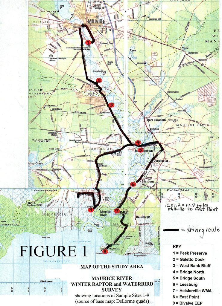
16 recorded. Note too that the major tributaries of the Maurice River the Menantico, the Manumuskin, and the Muskee were not included (counted) by this methodology. Similarly, in the Great Egg studies, the large and important Tuckahoe River tributary was not covered by this method (nor was Great Cedar Swamp Creek), excepting for the site in the Tuckahoe Unit of the Tuckahoe WMA. Given that only the lower portion of the Tuckahoe River was counted, and not the upper tidal portion, good numbers waterfowl (and raptors) present in the system were routinely missed, supporting the premise that overall daily counts shown for the river are conservative. Adding an upper Tuckahoe River point count site (or sites on the Maurice River s tributaries) might have been desirable, but not practical or even do-able given the short daylengths of mid-winter. For raptors however, peak seasonal counts -- usually obtained when conditions were ideal and most raptors were up and soaring -- are probably fairly close to actual numbers present. With the same two individual observers (Clay Sutton and Jim Dowdell on the Maurice, Great Egg and Mullica; Clay Sutton and Pat Sutton [and/or Ward Dasey] on the Cohansey and Salem) conducting the counts for twenty-five years, protocols have been both fine-tuned and little-changed. In short, because of the same individual observers, findings for each and all of the entire twenty-five years (Maurice) and also those for each of the other rivers are almost uniquely comparable. Few long-term studies can boast of the non-biased aspect of having the same investigator or investigators present on every single sampling date. Also, few studies can claim the optimal weather conditions for each survey that having two locally-based observers available allowed. Field days were not locked into the calendar, but instead chosen, often on short notice, for days that the weather would allow for excellent counting conditions. Maurice River The Maurice River was the river that started it all. It was the first river to be monitored for wintering raptors and waterfowl, and the river that spawned the design, protocols, and methodologies that were subsequently employed on the other four major South Jersey rivers. The Maurice River has been sampled an amazing 234 times in the 25 year period stretching from 1987 to The nine count locations, the official Point Count methodology sampling sites, are shown on the map included here as Figure 1. Also shown is the 37.4 mile transect route that connected the points. Some sites did have supplemental count locations (labeled A, B, and C on our original field maps, but not on Figure 1) to allow for all areas to be seen and thereby most birds counted. For example, the Heislerville Wildlife Management Area (WMA) site, Site 7, at Matt s Landing has three impoundment pools, and not all pools can be viewed or counted from the same immediate location. Therefore, the daily Site 7 count is a composite of tallies taken at three separate but nearby locations, but only one final tally was given for the site on the daily and summary data sheets. In this case, the approximately 45 minutes are expended at the three stops put together. A similar situation exists at the Bivalve site; perhaps raptors might be reasonably counted from a single location, but waterfowl, shorebirds and other waterbirds present cannot all be seen from a single spot. Only by using such supplemental viewing locations could all waterbirds be reasonably and reliably tallied to the greatest extent possible. One caveat regarding protocol is that when high numbers of birds of many species are present, it may take more than the prescribed 45 minutes to reliably count them. On short early winter days, this might mean 16
17 that other sites populated by comparatively many fewer birds might of necessity be counted for a period less than 45 minutes. From the stated conservation goals standpoint, it was important to conduct the survey in a manner that would most reliably count and document the most birds present. The nine Maurice River Point Count sites chosen as part of a reasonable and do-able sampling route are as follows. They essentially monitor the 14.4-mile long tidal stretch of the river between the dam at Millville (Union Lake) and the Delaware Bay at East Point (in Maurice River Township): 1. The Peek Preserve of the Natural Lands Trust, Inc. This site, at the modest canoe landing by the office, allowed counting of the largely fresh water section adjacent to The Nature Conservancy s (TNC) Maurice River Bluffs Preserve. 2. Private dock at the Galetto Property (private property used with permission). North of Laurel Lake, this site allowed for a key and expansive overview of a lengthy section of the brackish (tidal) portion of the Maurice River. 3. West bank of Maurice River, near Buckshutem Road. Just south of Laurel Lake; a small bluff at a New Jersey Conservation Foundation property, at a section of the river known as Sweet Meadows. 4. Foot of the Maurice River Bridge on the north side of the Maurice River Causeway. West side of the river, on the berm of the bridge, looking north over the tidal river and wetlands. 5. Foot of the Maurice River Bridge on the south side of the Maurice River Causeway. East side of the river, looking south over the tidal river and wetlands. (Note: although these two sites are immediately adjacent, the bridge and embankments do not allow a view in both directions at once; Site 4 faces to the north and Site 5 faces to the south). 6. East bank of the Maurice River adjacent to Maurice River Road. Just south of Leesburg in Maurice River Township; a tidal river and wetlands overlook. 7. Heislerville Wildlife Management Area (WMA). As stated above, this is actually three sites in one, to allow for the counting of waterfowl in each of the three tidal impoundments (no single spot allows an observer to see all three impoundments at once.) The three overlooks or views are counted as one site in all analyses; each site is located at each of the outfalls of the three individual impoundments. Overall, this location allows for a view of the Basket Flats area mudflats (at low tide) and the shallow bay waters (at high tide). 8. East Point Lighthouse. The seawall at the parking lot / boat ramp offers an excellent view of all of Maurice River Cove -- a shallow, open-water area of Delaware Bay that is used by substantial numbers of diving ducks in winter (and shorebirds in spring). 17
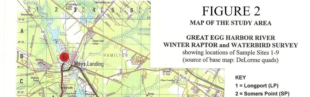
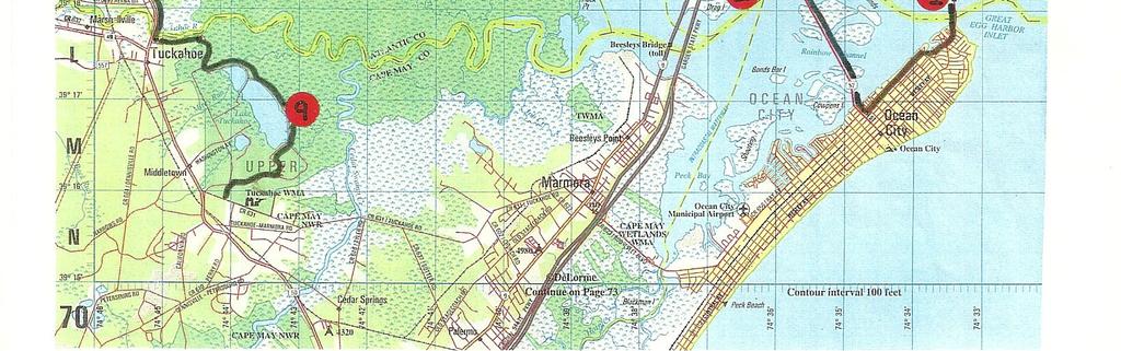
18 9. Bivalve, also known as the Commercial Township Estuary Enhancement Program (EEP) Site owned by Public Service Electric and Gas (PSE&G). As with Heislerville WMA, no single point allows one to see all the tidal impoundments at once. Therefore Site 9 is also three sites in one: (1) the berm and boardwalk off CR 631 south of Port Norris; (2) the boardwalk and observation platform off Strawberry Avenue, south of Route 553, in Port Norris; and (3) the berm at the west end of the impoundments at Berrytown Road. Great Egg Harbor River The Great Egg Harbor River is 49 miles long and drains a land area of approximately 304 square miles. The upper portions of the river corridor are largely wooded and do not lend themselves to easy sampling/counting of either raptors or waterfowl (nor are raptors or ducks as generally prevalent or as concentrated/abundant as on the tidal lower river portions of the system). The tidal portion of the Great Egg stretches about 12.6 miles (as measured on the centerline of the river) from the dam at Lake Lenape in Mays Landing to the mouth of the river (on a line connecting the beaches of Ocean City and Longport) where it meets the ocean in Great Egg Harbor Inlet. The 12.6 miles of tidal river and bay were sampled by this study. The Great Egg Harbor River was sampled 82 times over the ten year period beginning in 2003 and ending in The nine count locations, the official Point Count methodology sampling sites, are shown on Figure 2. Some sites did have supplemental count locations (labeled A, B, and C on our original field maps, but not on Figure 2) to allow for all areas to be seen and thereby most birds counted. For example, the Tuckahoe Wildlife Management Area site (Site 9) southeast of Tuckahoe has three impoundment pools, and not all pools can be viewed or counted from the same immediate location. Therefore, the Site 9 count is a composite of tallies taken at three separate locations, but only one final tally is given for the site on the daily and summary data sheets. In this case, the 45 minutes are expended at the three stops put together. Only by using such supplemental viewing locations could all birds, particularly waterbirds, be reasonably and reliably tallied to the greatest extent possible. In order to avoid time-of-day bias in the sampling technique, the route was reversed on each subsequent sampling date, run upriver and then downriver on alternate sampling days. As with the Maurice River, to the greatest extent practicable, all Great Egg counts were conducted in good weather. The observers carefully selected sampling days which were sunny and breezy, conditions which readily facilitate raptor hunting and movement along the river. Such conditions particularly allow for the best raptor counts; on cloudy, windless days raptors often spend much of their time perched, and therefore often are out of sight. While the technique used might be considered to be a combination of the time-honored point count and transect methods, birds recorded during the transits from site to site were infrequent and only included under the caveats expressed above. None-the-less, the route was always virtually the same, decreasing any variability possibly associated with this technique. The transect portion of the study the driving route was 44.1 miles in length, stretching from the Longport Bridge north and west to Mays Landing, then down the west side of the river to Tuckahoe WMA. This route 18
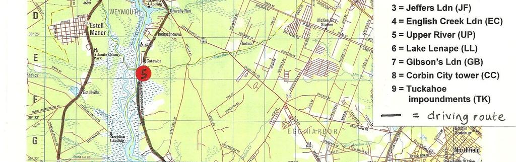
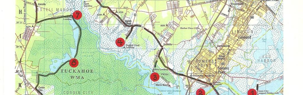
19 is also shown on Figure 2. In essence this study used standard point count techniques, yet did attempt to maximize sightings by adding any key observations gained while in transit -- thereby gaining a full picture of the numbers and diversity of the considerable avian resources present. The nine sites ultimately settled upon as part of a reasonable, practical, representative, and opportunistic sampling route are as follows, (starting on the lower estuary and working upriver, and then back down to Tuckahoe): 1. Longport Bridge Fishing Pier. This site allowed counting of the lower portion of Great Egg Harbor Bay and the Rainbow Channel/Rainbow Island area. Observations were made from both sides of the road so that the entire bay could be seen and counted. 2. John F. Kennedy Park in Somers Point. Allowed counting of the bay east of the Garden State Parkway Bridge. A supplemental site was employed here; the foot of the Route 9 Bridge over Great Egg Harbor bay (north end) allowed the bay west of the bridges to be seen and censused. 3. Jeffers Landing, including a supplemental site (looking west at otherwise unseen pockets) on Job s Point Road. 4. English Creek Landing at Wharf Road. Both Jeffers Landing and English Creek Landing afforded excellent views of the vast and wide estuary where the river meets the bay. 5. The Upper tidal river. The regular count location was from the Shady River Marina on Route 559. A supplemental site used rarely (if and when waterfowl -- primarily Canada Geese -- were noted to be present in numbers) was the bulkhead in Mays Landing just south of Route Lake Lenape. Observations were conducted from the berm adjacent to the dam s spillway in Mays Landing, just off CR 616, which offers an excellent view of the lake (and the winter Bald Eagle roost that is often present). 7. Gibson Landing, at the end of Gibson s Creek Road, at the northern end of the Corbin City unit of Tuckahoe WMA. 8. Corbin City WMA. The count was taken from the observation tower on the dike (wildlife drive) of the Corbin City unit of the Tuckahoe WMA. Here supplemental observation points were used in order to observe and count all of the various nooks and crannies of the several impoundments. 9. Tuckahoe WMA, from the dike (wildlife drive) of the Tuckahoe unit of the Tuckahoe WMA, including three supplemental stops which allowed all three impoundments to be viewed. Particularly Site 9 allowed those raptors and waterfowl using the lower Tuckahoe River tributary to the Great Egg Harbor River basin to be included in survey results. This site was in Cape May County; all other sites were in Atlantic County. 19
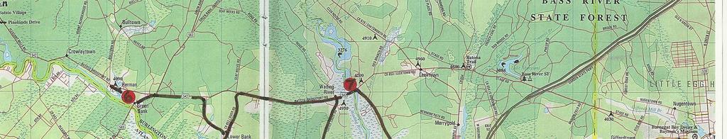
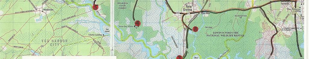
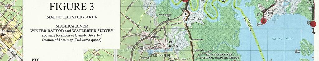
20 Mullica River The Mullica River was the third funded survey, carried out for the Great Egg Harbor Watershed Association in order to allow for direct and important comparisons and thereby perspective to the Great Egg. The Mullica River study area and sample locations are shown on Figure 3. The methodology used on the Mullica was designed to be identical to that used on the Great Egg: nine sample locations were established on the Mullica between Green Bank in the west and on downriver to Great Bay Boulevard near Little Egg Inlet. As with the other rivers, each site was visited for 45 minutes each during a given survey, and sampling direction was reversed every other survey to avoid time-of-day bias. The length of the tidal river surveyed was 15.6 miles, and the transect driving route was 42.3 miles. The Mullica was monitored a total of 42 times over nine winter seasons from 2004 to The nine sites, numbered and beginning at the mouth of the river and then working upriver, were as follows: The sites north of the river are in Burlington and Ocean Counties; the sites south of the river are in Atlantic County. 1. Great Bay Boulevard WMA (where Great Bay Boulevard, aka Seven Bridges Road, dead-ends at lower Great Bay/Little Egg Inlet). Counts were made from the beach, just east of the Rutgers University Field Station. 2. Graveling Point, at the parking lot at the public beach. Sites 1 and 2 both census Great Bay, but they are far enough apart that there is no possibility of over-counting or doublecounting waterfowl in this very large bay. 3. The area upriver of the Garden State Parkway was counted from an overlook under (on the west side) the Garden State Parkway Bridge over the Mullica. It was accessed via Chestnut Neck. 4. Swan Bay WMA, at the end of Turtle Creek Road (after it becomes a gravel road), at the small boat launch. 5. Lower Bank, from River Road/CR Green Bank, from Rt. 542, on the north bank of the river. 7. The major Wading River tributary was monitored on the lower river at the Wading River Bridge (Rt. 542). 8. The lower Bass River tributary was counted at Amasas Landing, just off Exit 50 of the Garden State Parkway. The count was done at the boat ramp. 9. The Leeds Point area, on the south side of Great Bay, was monitored from Oyster Creek (Alternate Route 561), and at an alternate overlook at the end of Mott s Creek Road. 20
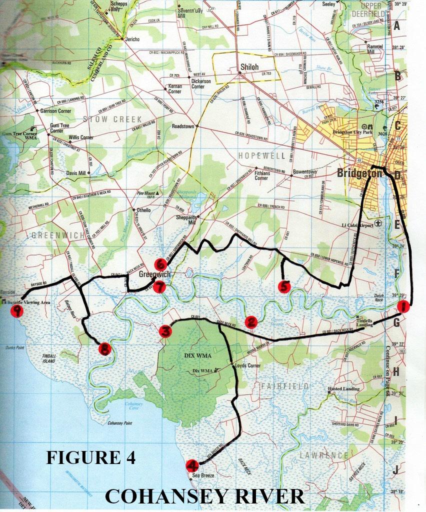
21 Cohansey River The Cohansey River in western Cumberland County has been studied the second-longest period of all the rivers, second only to the Maurice. Cohansey studies began in 1990, and were carried out through winter (and are ongoing today). A total of 64 surveys were conducted on the Cohansey over 23 winter seasons. The survey covered the 13.5 miles of tidal river, from the dam at Sunset Lake in Bridgeton to the mouth of the river below Greenwich. The driving route transect was 31.6 miles in length. The nine point count sites are shown in Figure 4. The individual sites are as follows: 1. The upper tidal river was counted from Duck Pond Road off CR 601/Back Neck Road near Tindall s Landing, and covered the area of the river known as Dutch Neck. 2. PSE&G Green Swamp boat launch and landing was a key overlook of the central portion of the river. 3. Dix WMA from the very end of Back Neck Road (where the asphalt becomes the gravel road of the WMA). 4. Sea Breeze Road covered the Cohansey Cove area of the Delaware Bay and the extensive wetlands to the north. Count taken at the turn around near the beach. 5. The other five point count locations were on the other (north) side of the Cohansey River. Percy Blew Road, off River Road, allowed for monitoring of the central Cohansey area. (Although somewhat near to the Green Swamp site across the river, Percy Blew was often a crucial area for wintering flocks of geese in farm fields. None-the-less, extra care was taken here not to double-count). 6. Greenwich North covered upriver from CR 607/Greenwich Road at Wheaton Run. 7. Greenwich South covered downriver from the foot of CR 741 where it dead-ends at the river. Although near to Site 6, there was little to no overlap in the areas viewed, with Site 6 offering views to the north and west, and Site 7 only yielding views to the south. 8. Tindall Island Road where it meets the Cohansey River. 9. The Bayside Viewing Area maintained by PSE&G at Bayside served as an overlook of both Tindall Island and the mouth of the Cohansey where it meets Delaware Bay. Salem River The final river added to the comparative study was the Salem River. With an eye toward completing the coverage of all the large South Jersey rivers, counts began in 2004 and continued for nine winter seasons. In all, 20 counts were made on an 11.4 mile stretch of the tidal Salem River. The driving route was 30.7 miles in length. Here the design, and counting, were a bit of a 21
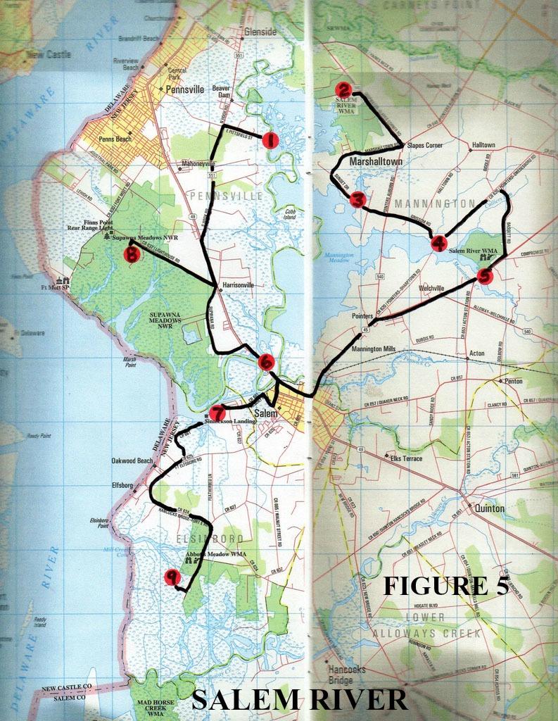
22 challenge, as the Salem River encompasses the well-known, wide and spacious Mannington Marsh area. Also, access was difficult in some sections due to large tracts of private (posted) land. The final choices of point count sites are shown in Figure 5, and are as follows: 1. The end of East Pittsfield Street off Rt. 551 near Pennsville overlooked the western sections of Mannington Marsh. 2. A site off Rt. 540, in Salem River WMA allowed for views to the north covering the upper Salem River west of Sharptown. 3. Sunset Drive crosses a tributary to Mannington Marsh and gave key (if distant) views of the center of Mannington Marsh. 4. Grissom Road where it meets CR 620, afforded good views of the Mannington Creek tributary, as did the next site. 5. Rt. 45 where it crosses Mannington Creek. Even though relatively near to Site 4, these locations overlooked different portions of Mannington Creek. Both sites were key areas for waterfowl use. 6. Rt. 49 where it crosses the Salem River. 7. Sinnockson Landing overlooks the mouth of the Salem River and a portion of the Delaware River itself. 8. The final two sites were outliers, chosen to get an overview of the very complex lower Salem River basin. A count was made in Supawna Meadows NWR off CR 632/Lighthouse Road. 9. The PSE&G Observation Tower at the end of Money Island Road near Elfsborg. Although off the main river, this site gave views to the north of the complex tributaries flowing north into the Salem River near its mouth, of extensive private farmlands, and of sections of Abbotts Meadow WMA. Only birds to the west and north of the site were counted, and not those seen off to the east well away from the river system. 22
23 23
24 24
25 25
26 26
27 27
28 FINDINGS The five major tidal river systems and associated estuaries of Southern New Jersey have been systematically studied for raptors and waterfowl (and to a lesser degree all waterbirds) for over 25 years, dating back to the winter season of when the first survey was conducted on the Maurice River. Table 1 shows a comparison of the five rivers and the scope of work carried out on each river. Shown are: the length of the tidal portions of each river surveyed; the length of the driving route employed to reach the point count sites; the total number of years studied; the years of the studies (the winter seasons, such as Winter ); and the total number of surveys carried out on each river. For this current comparison report, for a number of reasons outlined below, not all years of data are used in our comparisons. Therefore Table 1 also shows the number of years that we have used in the comparisons; the dates of the winters compared; and the number of individual surveys compared (that is, the number [N] used in computing the averages for each of the key bird species). Finally, Table 1 also shows the dates (winter seasons) for which historical data exists for each river; and the number (N) of historical individual surveys available to be used in computing the historical averages. Comparing historical findings to current findings gives great insight into the changes and trends seen along the rivers over time. In all, a total of 445 individual winter raptor and waterfowl surveys have been conducted during the 26 calendar years that this study encompasses. That figure rises to 492 surveys if and when historical surveys (non-standardized not using the methodology of the 445 new or modern studies) are included. This undoubtedly gives us one of the larger databases of any ornithological studies in New Jersey and possibly in the entire Mid-Atlantic Region. The fact that Clay Sutton was one of the two counters on approximately 99% of the individual counts allows for an unusual degree of comparison in regards to protocol. In fact, these studies are therefore virtually unique among similar monitoring efforts in that observer bias is all but completely eliminated by always having the same observer present. All studies that call for sight identifications and an estimation of numbers involve some subjective choices (as opposed to, for example, water quality studies where values are obtained by reading a scientific instrument), but by having the same principal observer making these subjective choices on each survey on each river, the data becomes almost uniquely comparable. The Maurice River The Maurice River was surveyed for wintering raptors and waterfowl an imposing 234 times over the 25 years presented and analyzed here. All data was recently presented and discussed in the report, RAPTORS, WATERFOWL, SHOREBIRDS AND WATERBIRDS ON THE MAURICE RIVER, CUMBERLAND COUNTY, NJ. A Twenty-five Year Summary of Observed Status and Trends, Clay Sutton and James Dowdell. October, pages. (Prepared and published for Citizens United to Protect the Maurice River and its Tributaries, Inc.). 28
29 However, because of observed and presented major changes in the status and trends of many species over this lengthy period, for the purposes of this report only the most recent 10 winter seasons (of the 25) are used for this comparison of the rivers. That is, since the Great Egg was surveyed for only 10 seasons, the Mullica for 9 seasons, and the Salem River for 9, only the recent 10 seasons of Maurice River data will be used in our comparisons. Also, similarly, only the most recent 10 years of the 23 total years of Cohansey River data will be employed in comparisons herein. For the Maurice River, a total of 90 winter surveys were carried out over the recent ten winter seasons, beginning in winter and running through winter , for an average of 9 surveys per winter. (Explanatory note and caveat: Even though Maurice River studies are ongoing to the present, the years to were used herein [as opposed to to ] simply because all analyses were carried out, and peaks and averages computed and charted, for the major 25 year Maurice River report published in To do so again with the one season difference would have required new review and computations unfortunately beyond the scope and time constraints of this current project/report. Simply put, this is why the calendar years don t exactly coincide for each river. We do however feel that this has negligible impact on the comparisons presented). The results of these ten seasons of winter raptor and waterfowl studies on the Maurice River are shown in Table 2. Table 2 shows seasonal peaks and seasonal averages for 22 key signature waterfowl and raptor species found on the Maurice River for each of the ten winter field seasons (these same species are key species discussed for all of the South Jersey Rivers). The highest daily count over the ten winter field seasons, or best count for each species, is Bold Faced in Table 2. Finally, the 2 nd page of Table 2 shows the ten year averages -- of both peak and average (mean) counts -- for the ten seasons of study. These overall averages allow for a good comparison of the Maurice River with the other four river systems. Great Egg Harbor River The Great Egg was sampled a total of 82 times over the ten winter seasons of study. All ten years of data are used in this comparison. An in-depth analysis/discussion was recently presented in the report WINTERING RAPTORS AND WATERBIRDS OF THE GREAT EGG HARBOR RIVER, ATLANTIC COUNTY, NJ. A Ten Year Summary of Observed Status and Trends, , Including Key Comparisons to the Mullica River, A review of Historical Data, and discussion of Spring and Fall Migration. Clay Sutton and James Dowdell. July pages. (Long-term studies sponsored by and published for the Great Egg Harbor Watershed Association). Because of the scope and depth of this recent report, the full body of Great Egg data will not be included here. However, Table 3 shows seasonal peaks and seasonal averages for 22 key signature waterfowl and raptor species found on the Great Egg Harbor River for each of the ten winter field seasons. The highest daily count over the ten winter field seasons, or best count for each species, is Bold Faced in Table 3. Finally, the 2 nd page of Table 3 shows the ten year averages -- of both peak and average (mean) counts -- for the ten seasons of study. This overall average allows for a comparison of the Great Egg with the other South Jersey rivers studied. 29
30 While average counts are of value in comparing data from year to year, and in part reflect the amount of time over the season which birds spend on the river (as well as the inevitable impacts of both daily and prolonged weather conditions upon count results), the peak count for many species far better reflects the true numbers present. For example, the peak of 1,238 American Black Ducks recorded on the Great Egg on February 1, 2004, far better represents the true number present, at least for a portion of the winter, than that year s seasonal average count of 365. Weather, ice, count conditions, tide, and access can greatly vary and alter the results of any given survey. This is why a minimum of 7-10 surveys per field season are required to confidently assess bird populations present in the system. Mullica River The Mullica River was surveyed for winter raptors and waterfowl a total of 42 times over the 9 winter seasons studied. The overall full data set was presented in the Great Egg Harbor ten year report mentioned above, and therefore is not included here. But as with the Maurice and Great Egg, Table 4 shows seasonal peaks and seasonal averages for 22 key signature waterfowl and raptor species found on the Mullica River for each of the nine winter field seasons. The highest daily count over the nine winter field seasons, or best count for each species, is Bold Faced in Table 4. Finally, the 2nd page of Table 4 shows the nine year averages -- of both peak and average (mean) counts -- for the nine seasons of study. Cohansey River Over a 23 year period ( ), the Cohansey River was monitored 67 times. While the results of individual season studies have been imbedded within the annual Maurice River reports -- for cursory and single season comparisons -- they have never been presented, analyzed or discussed in their entirety. Therefore, the complete Cohansey findings over the 23 years are included here. The results of the full 23 seasons of winter raptor and waterbird studies on the Cohansey River are attached as Appendix 1. Appendix 1 shows the peak numbers for all raptor and all waterbird species for each of the 23 seasons of study. (Note that in the 14 th season, winter , we began to tally all waterbirds, including shorebirds, and not just ducks and geese). The highest daily counts for all 23 seasons of study are Bold Faced. Table 5 represents essentially a smaller subset of Appendix 1 and shows key signature raptor and waterfowl species found on the Cohansey River during the final 10 years of study. Table 5 shows seasonal peaks and seasonal averages for 22 key signature waterfowl and raptor species found on the Cohansey River for each of the ten winter field seasons. The highest daily count over the ten winter field seasons, or best count for each species, is Bold Faced in Table 5. Finally, the 2nd page of Table 5 shows the ten year averages -- of both peak and average (mean) counts -- for the ten seasons of study, and this approach allows for a comparison of the Cohansey River with the other four subject South Jersey rivers. 30
31 Salem River The Salem River, the last of the rivers to be added to this comparative study, was surveyed a total of 20 times over a 9 year period from winter through winter Like the Cohansey (above), data for the Salem River has never been published in its entirety, and therefore is presented here. The results of the 9 seasons of winter raptor and waterbird studies on the Salem River are shown in Appendix 2. Appendix 2 shows the peak numbers for all raptor and all waterbird species for each of the nine seasons of study. Finally, Table 6 represents a smaller subset of Appendix 2, and shows seasonal peaks and seasonal averages for 22 key signature waterfowl and raptor species found on the Salem River for each of the nine winter field seasons. The highest daily count over the nine winter field seasons, or best count for each species, is Bold Faced in Table 6. Finally, the 2nd page of Table 6 shows the nine year averages -- of both peak and average (mean) counts -- for the nine seasons of study, allowing for a comparison to all the other rivers. Comparisons The important comparisons between the winter waterfowl and raptor populations of the five great South Jersey rivers are shown in Table 7. Highest daily counts for the study period, as well as averages (average peaks and average means) for key species are included for each of the five river systems. In this way, all five rivers can be compared and contrasted at a glance. And last but not least, although more for the ornithological record and quick reference point than for any true comparisons or analyses, peak all-time winter counts (over all the years of study, not just those being compared in Table 7) of all raptor and waterfowl species for each river are shown in Table 8. Twenty-five intensive seasons of study on the rivers of Southern New Jersey (actually now 28, as studies on the Maurice River are ongoing) have documented high concentrations of wintering raptors, wintering waterfowl, and other waterbirds. These populations are deemed significant and substantial for all of New Jersey, the Mid-Atlantic Region, and the entire Atlantic Coast. Few areas have reported numbers that rival those found on the great South Jersey rivers, and fewer still if any can claim the systematic documentation that is now available for the Maurice, Great Egg, Mullica, Cohansey and Salem Rivers. This data set for these rivers clearly establishes them as the best studied rivers in New Jersey and in the region, and documents remarkable raptor and waterfowl numbers at a level few other areas or sites can match. Finally, through these studies and the achievement of the goals and objectives, we have gained important publicity and awareness -- understanding that has brought overdue recognition to the extraordinary avian resources and ecotourism opportunities of the great Southern New Jersey rivers and estuaries. 31
32 TABLE 1 Winter Waterfowl and Raptor Surveys SOUTH JERSEY RIVER COMPARISONS RIVER LENGTH of RIVER LENGTH of ROUTE TOTAL NUMBER of YEARS SURVEYED DATES SURVEYED TOTAL NUMBER of SURVEYS NUMBER of YEARS COMPARED IN THIS REPORT DATES COMPARED NUMBER of SURVEYS COMPARED HISTORICAL SURVEYS NUMBER of HISTORICAL SURVEYS MAURICE 14.4 miles 37.4 miles * 21 COHANSEY 13.5 miles 31.6 miles * 12 SALEM 11.4 miles 30.7 miles none 0 GREAT EGG 12.6 miles 44.1 miles MULLICA 15.6 miles 42.3 miles total surveys 445 *(see"discussion") 32
33 WATERFOWL TABLE 2 (page 1) Peak and Average Numbers of Key Species of Wintering Waterfowl and Raptors on the MAURICE RIVER Ten Year Summary: Winter to Winter PEAK AVG. PEAK AVG. PEAK AVG. PEAK AVG. PEAK AVG. PEAK AVG. (N = 11) (N = 10) (N = 8) (N = 10) (N = 9) (N = 9) Snow Goose Brant Canada Goose American Black Duck Mallard Northern Pintail Green-winged Teal Bufflehead Red-Breasted Merganser RAPTORS Black Vulture Turkey Vulture Bald Eagle Northern Harrier Sharp-shinned Hawk Cooper's Hawk Northern Goshawk Red-shouldered Hawk Red-tailed Hawk Rough-legged Hawk Golden Eagle American Kestrel Merlin Peregrine Falcon Highest daily count over ten year period is Bold Faced N = number of surveys per field season 33
34 TABLE 2 (page 2) Peak and Average Numbers of Key Species of Wintering Waterfowl and Raptors on the MAURICE RIVER Ten Year Summary: Winter to Winter WATERFOWL Snow Goose Brant Canada Goose American Black Duck Mallard Northern Pintail Green-winged Teal Bufflehead Red-Breasted Merganser year PEAK AVG. PEAK AVG. PEAK AVG. PEAK AVG. Average Average (N = 8) (N = 8) (N = 8) (N = 9) of Peaks of Averages NA RAPTORS Black Vulture Turkey Vulture Bald Eagle Northern Harrier Sharp-shinned Hawk Cooper's Hawk Northern Goshawk Red-shouldered Hawk Red-tailed Hawk Rough-legged Hawk Golden Eagle American Kestrel Merlin Peregrine Falcon Highest daily count over ten year period is Bold Faced N = number of surveys per field season 34
35 TABLE 3 (page 1) Peak and Average Numbers of Key Species of Wintering Waterfowl and Raptors on the GREAT EGG HARBOR RIVER Ten Year Summary: Winter to Winter PEAK AVG. PEAK AVG. PEAK AVG. PEAK AVG. PEAK AVG. PEAK AVG. (N = 8) (N = 9) (N = 7) (N = 9) (N = 10) (N = 8) WATERFOWL: Snow Goose Brant Canada Goose American Black Duck Mallard Northern Pintail Green-winged Teal Bufflehead Red-breasted Merganser RAPTORS: Black Vulture Turkey Vulture Bald Eagle Northern Harrier Sharp-shinned Hawk Cooper s Hawk Northern Goshawk Red-shouldered Hawk Red-tailed Hawk Rough-legged Hawk Golden Eagle American Kestrel Merlin Peregrine Falcon Highest daily count over ten year period is Bold Faced N = number of surveys per field season 35
36 TABLE 3 (page 2) Peak and Average Numbers of Key Species of Wintering Waterfowl and Raptors on the GREAT EGG HARBOR RIVER Ten Year Summary: Winter to Winter WATERFOWL: Snow Goose Brant Canada Goose American Black Duck Mallard Northern Pintail Green-winged Teal Bufflehead Red-breasted Merganser year PEAK AVG. PEAK AVG. PEAK AVG. PEAK AVG. Average Average (N = 8) (N = 8) (N = 8) (N = 8) of Peaks of Averages RAPTORS: Black Vulture Turkey Vulture Bald Eagle Northern Harrier Sharp-shinned Hawk Cooper s Hawk Northern Goshawk Red-shouldered Hawk Red-tailed Hawk Rough-legged Hawk Golden Eagle American Kestrel Merlin Peregrine Falcon NA Highest daily count over ten year period is Bold Faced N = number of surveys per field season 36
37 TABLE 4 (page 1) Peak and Average Numbers of Key Species of Wintering Waterfowl and Raptors on the MULLICA RIVER Nine Year Summary: Winter to Winter PEAK AVG. PEAK AVG. PEAK AVG. PEAK AVG. PEAK AVG. (N = 5) (N = 7) (N = 6) (N = 8) (N = 4) WATERFOWL: Snow Goose Brant Canada Goose American Black Duck Mallard Northern Pintail Green-winged Teal Bufflehead Red-breasted Merganser RAPTORS Black Vulture Turkey Vulture Bald Eagle Northern Harrier Sharp-shinned Hawk Cooper s Hawk Northern Goshawk Red-shouldered Hawk Red-tailed Hawk Rough-legged Hawk Golden Eagle American Kestrel Merlin Peregrine Falcon Highest daily count over nine year period is Bold Faced N = number of surveys per field season 37
38 TABLE 4 (page 2) Peak and Average Numbers of Key Species of Wintering Waterfowl and Raptors on the MULLICA RIVER Nine Year Summary: Winter to Winter WATERFOWL: Snow Goose Brant Canada Goose American Black Duck Mallard Northern Pintail Green-winged Teal Bufflehead Red-breasted Merganser year PEAK AVG. PEAK AVG. PEAK AVG. PEAK AVG. Average Average (N = 4) (N = 3) (N = 3) (N = 2) of Peaks of Averages RAPTORS: Black Vulture Turkey Vulture Bald Eagle Northern Harrier Sharp-shinned Hawk Cooper s Hawk Northern Goshawk Red-shouldered Hawk Red-tailed Hawk Rough-legged Hawk Golden Eagle American Kestrel Merlin Peregrine Falcon NA Highest daily count over nine year period is Bold Faced N = number of surveys per field season 38
39 TABLE 5 (page 1) Peak and Average Numbers of Key Species of Wintering Waterfowl and Raptors on the COHANSEY RIVER Ten Year Summary: Winter to Winter PEAK AVG. PEAK AVG. PEAK AVG. PEAK AVG. PEAK AVG. PEAK AVG. (N = 4) (N = 3) (N = 3) (N = 3) (N = 5) (N = 5) WATERFOWL Snow Goose Brant Canada Goose American Black Duck Mallard Northern Pintail Green-winged Teal Bufflehead Red-breasted Merganser RAPTORS Black Vulture Turkey Vulture Bald Eagle Northern Harrier Sharp-shinned Hawk Cooper s Hawk Northern Goshawk Red-shouldered Hawk Red-tailed Hawk Rough-legged Hawk Golden Eagle American Kestrel Merlin Peregrine Falcon Highest daily count over ten year period is Bold Faced N = number of surveys per field season 39
40 TABLE 5 (page 2) Peak and Average Numbers of Key Species of Wintering Waterfowl and Raptors on the COHANSEY RIVER Ten Year Summary: Winter to Winter WATERFOWL Snow Goose Brant Canada Goose American Black Duck Mallard Northern Pintail Green-winged Teal Bufflehead Red-breasted Merganser Year PEAK AVG. PEAK AVG. PEAK AVG. PEAK AVG. Average Average (N = 3) (N = 4) (N = 3) (N = 3) of Peaks of Averages NA NA RAPTORS Black Vulture Turkey Vulture Bald Eagle Northern Harrier Sharp-shinned Hawk Cooper s Hawk Northern Goshawk Red-shouldered Hawk Red-tailed Hawk Rough-legged Hawk Golden Eagle American Kestrel Merlin Peregrine Falcon Highest daily count over ten year period is Bold Faced N = number of surveys per field season NA NA
41 TABLE 6 (page 1) Peak and Average Numbers of Key Species of Wintering Waterfowl and Raptors on the SALEM RIVER Nine Year Summary: Winter to Winter PEAK AVG. PEAK AVG. PEAK AVG. PEAK AVG. PEAK AVG. (N = 1) (N = 1) (N = 3) (N = 3) (N = 3) WATERFOWL: Snow Goose Brant Canada Goose American Black Duck Mallard Northern Pintail Green-winged Teal Bufflehead Red-breasted Merganser RAPTORS Black Vulture Turkey Vulture Bald Eagle Northern Harrier Sharp-shinned Hawk Cooper s Hawk Northern Goshawk Red-shouldered Hawk Red-tailed Hawk Rough-legged Hawk Golden Eagle American Kestrel Merlin Peregrine Falcon Highest daily count over nine year period is Bold Faced N = number of surveys per field season 41
42 TABLE 6 (page 2) Peak and Average Numbers of Key Species of Wintering Waterfowl and Raptors on the SALEM RIVER Nine Year Summary: Winter to Winter WATERFOWL: Snow Goose Brant Canada Goose American Black Duck Mallard Northern Pintail Green-winged Teal Bufflehead Red-breasted Merganser Year PEAK AVG. PEAK AVG. PEAK AVG. PEAK AVG. Average Average (N = 2) (N = 3) (N = 2) (N = 2) of Peaks of Averages NA RAPTORS Black Vulture Turkey Vulture Bald Eagle Northern Harrier Sharp-shinned Hawk Cooper s Hawk Northern Goshawk Red-shouldered Hawk Red-tailed Hawk Rough-legged Hawk Golden Eagle American Kestrel Merlin Peregrine Falcon NA NA Highest daily count over nine year period is Bold Faced N = number of surveys per field season 42
43 TABLE 7 Comparisons of Winter Waterfowl and Raptor Populations of the Five South Jersey Rivers Maurice River 10 years ( ) Cohansey River 10 years ( ) Salem River 9 years ( ) Great Egg Harbor River 10 years ( ) Mullica River 9 years ( ) Highest Avg. Avg. of Highest Avg. Avg. of Highest Avg. Avg. of Highest Avg. Avg. of Highest Avg. Avg. of WATERFOWL Count of Peaks Averages Count of Peaks Averages Count of Peaks Averages Count of Peaks Averages Count of Peaks Averages Snow Goose Brant NA NA 0 NA NA Canada Goose American Black Duck Mallard Northern Pintail Green-winged Teal Bufflehead Red-breasted Merganser RAPTORS Black Vulture Turkey Vulture Bald Eagle Northern Harrier Sharp-shinned Hawk Cooper's Hawk Northern Goshawk NA NA Red-shouldered Hawk Red-tailed Hawk Rough-legged Hawk Golden Eagle NA NA 0 NA NA American Kestrel Merlin Peregrine Falcon
44 TABLE 8 (page 1) All-Time Winter High Count (Single Day Count) by River, RIVER MAURICE COHANSEY SALEM GREAT EGG MULLICA No. of years surveyed: 25 years 23 years 9 years 10 years 9 years WATERFOWL Gr. White-fronted Goose 1 4 Ross's Goose Snow Goose Canada Goose Cackling Goose Brant Mute Swan Tundra Swan Wood Duck Gadwall Eurasian Wigeon American Wigeon American Black Duck Mallard Blue-winged Teal Northern Shoveler Northern Pintail Green-winged Teal Canvasback Redhead Ring-necked Duck Greater Scaup Lesser Scaup scaup (sp.) Common Eider Harlequin Duck 1 2 Surf Scoter White-winged Scoter Black Scoter scoter (sp.) Long-tailed Duck Bufflehead Common Goldeneye Hooded Merganser Common Merganser Red-breasted Merganser Ruddy Duck
45 TABLE 8 (page 2) All-Time Winter High Count (Single Day Count) by River, RIVER MAURICE COHANSEY SALEM GREAT EGG MULLICA No. of years surveyed: 25 years 23 years 9 years 10 years 9 years RAPTORS Black Vulture Turkey Vulture Bald Eagle Northern Harrier Sharp-shinned Hawk Cooper's Hawk Northern Goshawk 1 (12 total) 1 (4 total) 1 (3 total) 1 (1 total) Red-shouldered Hawk Red-tailed Hawk Rough-legged Hawk Golden Eagle American Kestrel Merlin Peregrine Falcon
46 DISCUSSION: WINTER RAPTORS OF THE SOUTH JERSEY RIVERS Wintering populations of birds of prey are a characteristic feature of coastal New Jersey woodlands and marshes. These raptor concentrations occur in part as a result of the well-known coastal fall migration of hawks through the region, as migrants pause and stage here, and (for many) then choose to remain in the food-rich, quality habitats available throughout southern New Jersey. While virtually all of New Jersey s Atlantic Coast and Delaware Bayshore salt marshes and associated uplands support numerous and diverse raptor populations, the large river systems and associated estuaries tend to attract and concentrate birds of prey in the largest numbers. This is in part due to a variety of habitat types and the related greater availability of prey species, and also because portions of the larger rivers will generally be, due to strong tidal flow, in part icefree even during the harshest of winters (and thereby concentrate regional waterfowl). The status and trends in river raptor populations, as well as their distribution, have been extensively addressed in previous summary reports to Citizens United to Protect the Maurice River and to the Great Egg Harbor Watershed Association, and will not be extensively reiterated here. The South Jersey river systems host large numbers of wintering raptors by any standard. Over 25 years of winter study have documented 15 species of wintering raptors (including vultures) on the rivers, with at least 13 species occurring on each river annually. Our tidal rivers host some of the highest assemblages of raptors in New Jersey, with similar numbers unrecorded, or at least unreported, elsewhere in the state. Accordingly, wintering raptors are a high ecovalue of the Southern New Jersey river systems. Diversity and numbers are excellent, not only for New Jersey, but also for the entire Mid-Atlantic coastal region. Species by species accounts follow, with discussions that mostly address current and overall status for the rivers as a whole. Specific comparisons and specific rivers will be discussed subsequently. Black Vultures continue to expand their range and numbers in New Jersey and in the Northeast. and in New Jersey. They are a southern species well known to rapidly be moving northward. They remain, however, somewhat uncommon away from the Delaware Bayshore and the Cape May peninsula in winter. They are none-the-less daily on all the rivers at all seasons. Turkey Vultures, sometimes called buzzards by locals, are a staple of winter on the rivers. Turkey Vultures are in sight daily in numbers at virtually all survey locations, and proof that nature s clean-up crew is hard at work on the rivers. Turkey Vultures have increased substantially over the course of the 25 years of work on the rivers, as they continue to push their range northward enabled to do so by warmer winters. Osprey, known to many as Fish Hawks, migrate to warmer climes in fall, and do not (normally) winter in the Mid-Atlantic; numbers that have been shown in yearly reports in the past are those spring arrivals recorded during the last survey of the winter season study period, during the third or fourth week of March. That said, in winter , an Osprey successfully wintered on the Great Egg, as did one on/adjacent to the Mullica River, at Forsythe NWR). Also, although not seen on our surveys, an Osprey was reliably reported on the Great Egg on 18 46
47 January On at least two occasions, one may have successfully wintered on the Maurice River. To our knowledge, these are the first winters that this has ever occurred, and -- reflecting warmer winter temperatures, warmer waters, and the availability of fish as prey wintering Osprey perhaps may be an indicator of climate change. Bald Eagles are today a hallmark of the great South Jersey rivers in winter, and over the long course of these studies the rapidly increasing numbers can easily be seen. Augmenting true wintering birds (mostly immatures) from farther north, a minimum of some 60 pairs of Bald Eagles today nest on the river systems of Southern New Jersey. Unlike in the not so distant past, Bald Eagles are a daily sight over the rivers and their tributaries. The upward trend and comeback of Bald Eagles would be even more readily seen had not the final four years of these comparative studies been rather mild with mostly ice-free waters. By far the most eagles are found during bitter cold winters when frozen conditions to our north drive them south to find an abundance of prey concentrated in the fast moving (and therefore open) waters of the South Jersey rivers and bays. Golden Eagle Whereas Bald Eagles nest in the region, Golden Eagles do not. Golden Eagles recorded in winter in New Jersey are migrants from the far north and west (most East Coast Golden Eagles breed in the James Bay/Hudson Bay region). The Great Egg and Mullica Rivers have proven to be one of the top areas in the East to see wintering Golden Eagles. Two to four individuals are recorded on each of these rivers in most winters. They are not as regular on the Delaware Bayshore, although the Maurice usually hosts one or two Goldens each winter. If the Bald Eagle is best described as more of an opportunist and even a scavenger, the Golden Eagle is characterized as a true hunter. Seeing a Golden high up in a gale, quartering the wind over the vastness of the Mullica or Great Egg -- a speck against the gray winter clouds, hunting Black Ducks that it takes on the wing in characteristic rocketing dives or stoops, -- was an infrequent yet always glowing highlight of these studies for the researchers/authors. Northern Harrier or Marsh Hawk is another popular and conspicuous signature species of the winter river marshes. They were recorded in large numbers on all the rivers, although recent daily averages for Harriers have declined, possibly as a result of coastal storms and habitat change associated with sea level rise. This was discussed in much greater detail in the prior reports mentioned above. Sharp-shinned Hawk This small forest-dwelling accipiter is secretive in winter, and certainly more numerous than those tallied on any given day. Peak numbers are usually counted in early winter, although such numbers usually reflect a very late fall migration movement that coincided with the very first days of the official winter count period (that begins 1 December each season). None-the-less, far more of these furtive hawks are present than are usually counted, and tallies shown herein are highly conservative for both Sharp-shinned and Cooper s. Cooper s Hawk Also somewhat secretive in winter, this larger accipiter is only very slightly less numerous than Sharp-shinned Hawk on the rivers. A substantial increase of wintering Cooper s has been seen on all rivers, again proving a suspected region-wide trend. Like Osprey and Bald Eagles, Cooper s Hawks have recovered in recent decades from a major decline linked to the former use of DDT. 47
48 Northern Goshawk The Goshawk is a very large accipiter of the northern forests. More irruptive (in response to food shortages) than truly migratory in the Mid-Atlantic, they only reach Southern New Jersey in fall in small numbers, and are very scarce in winter. Goshawks are uncommon to rare anywhere in New Jersey in winter and generally secretive as well. Accordingly, sighting and counting a Gos on a winter survey always makes for a red-letter day! Table 8 clearly shows the paucity of Goshawk numbers in Southern New Jersey in winter, with only 20 sightings accrued overall on all the rivers. Red-shouldered Hawk is another forest-dwelling raptor that is always no doubt considerably more numerous than those seen and recorded. Most are migrants from the northern forests, and most are seen during the coldest winter days when they sit low on sunlit edges both to warm up and to seek prey attracted and activated by the sun and warmth. They are more numerous on the Delaware Bayshore rivers than on the Atlantic coast river systems. Red-shoulders seem to have increased slightly in recent years, perhaps reflecting the warmer winters as more birds winter farther north than previously. Red-tailed Hawk Red-tails are by far the most conspicuous of all our wintering hawks, and were present along the length of all rivers in excellent numbers attracted by the feeding opportunities offered by the bounty of the vast salt marshes and upland edge. Highest numbers were recorded in early winter or late winter when late fall migrants or early spring migrants augmented local resident and wintering Red-tailed Hawks. Red-tails are a common and welcome part of the river landscapes at any season, yet a bird that has appeared to decline significantly in the final three years of study. This is possibly due to the impacts of major storms and tidal flooding on its rodent prey base (see discussions in previous studies). Rough-legged Hawk Even though it is found in small numbers (low density), the Rough-legged Hawk can be thought of as a flagship species of the Great Egg and Mullica River winter wetlands. Even prior to these studies, both the Mullica River and the Tuckahoe/Corbin City/Great Egg complex were widely known as two of the very best places to see Rough-legged Hawks in New Jersey. These surveys only confirmed and corroborated this reputation. Each winter season, the vast marshes of the lower rivers attract good but variable numbers of this charismatic winter visitor from the high Arctic regions. The irruptive and nomadic behavior of Rough-legs results in counts that vary considerably from year to year on the rivers. That said, there is evidence when comparing the data over time of a decline in Rough-leg use of the rivers, particularly on the Maurice River, possibly linked to habitat change, sea level rise, and coastal storm events (also see discussions in previous reports). It is well-known that many or most Rough-legs remain farther north during milder winters. American Kestrel This small falcon was once a staple in southern New Jersey, gracing pastures, meadows, and roadsides alike. Yet during these surveys, very few were seen, and even those that were seen represented mostly early spring migrants, not true wintering birds. The American Kestrel, once common in the general area, has today virtually disappeared as a wintering bird (and nesting bird.) throughout southern New Jersey (see comments under historical data). This was perhaps the most sobering finding of all, as we realize that this former keystone species has almost completely vanished in a few short decades. 48
49 Merlin are northern forest nesters and highly migratory. Most Merlin spend the winter far to the south of New Jersey, yet a few always remain in our area near the northern limit of their winter range. One to two are present during most winters on most of the rivers, but due to their habits and large territories, finding them may be more a matter of timing and even luck than for any of the other raptors that are regularly counted. Low Merlin numbers was a somewhat surprising finding, as Merlin are decidedly more prevalent in southern Cape May County in winter. Peregrine Falcon Resident Peregrines, stemming from the reintroduction of the once-vanished eastern population, are supplemented in winter by other wintering birds, usually immatures. The Peregrine is another former victim of DDT that has recovered exceptionally well in recent decades, and an increase can readily be seen when comparing the early and later years of these studies. Although uncommon (low density), Peregrines are fast, powerful and iconic hunters of ducks and shorebirds on the expansive, wide-open marshes of the rivers and vast estuaries, and always a welcome find during our winter searches. Gyrfalcon The largest, most powerful, and most revered falcon, the Gyr is a bird of the high arctic, only wandering as far south as New Jersey on very rare occasions. We have never recorded one in our 25 years of study, yet two were seen by reliable observers on our rivers during the study period one on the Cohansey River (seen by many during the Cumberland County Christmas Bird Count) and one photographed on the Salem River at Mannington Marsh. Both were one day only records, not atypical for the wide-ranging Gyr. Prior to the beginnings of these counts, from November 1982 to April 1983 a white morph Gyrfalcon wintered on and near the lower Great Egg (seen by Clay Sutton and a few others on several occasions), and historically there are at least three records of Gyrs wintering on the lower Mullica River, at and near Forsythe NWR. Gyrfalcons are the rarest of the rare, and easily the Holy Grail of those searching for winter raptors. Short-eared Owl Crepuscular (active in the dim light of dawn or dusk) if not truly diurnal in its habits, the Short-eared Owl is the one owl which can be (in-part) censused during daylight hours. As with Rough-legged Hawk, the high marsh areas of the lower rivers have long been known to be the best and most reliable places in all of New Jersey to find and enjoy Short-eared Owls. An irruptive species, they were recorded in numbers during only some winter seasons. (Numbers are not shown herein; see specific seasonal reports for more information). However, a marked decline in numbers during the more recent years of these studies (more anecdotal than proven, as our protocols do not provide for reliable/adequate counting of this owl) is troubling, and may well be linked to the observed losses in Rough-legged Hawk and Northern Harrier due to climate change, sea level rise, and coastal flooding (see discussions in previous major reports). 49
50 DISCUSSION: WINTER WATERFOWL OF THE SOUTH JERSEY RIVERS Waterfowl use of the South Jersey rivers is a signature avian phenomenon -- substantial and highly significant in the region and in New Jersey. Thirty-five species of waterfowl (and two notable subspecies) were found by survey efforts over the many years of study, and high regional winter concentrations were documented for a number of key species. All rivers were deemed significant for their winter waterfowl populations. See the previous major reports prepared for both the Maurice River and the Great Egg Harbor River for greater detail and discussion. Canada Goose While some Canadas are no doubt non-migratory local geese, the high midwinter counts also include many wild migrant Canada Geese driven to the region by snow and ice conditions farther north. Numbers have increased somewhat over the study period, but without the meteoric increase that one might expect. It is possible however, indeed likely, that the substantial increase in local geese is being masked by the well-known decline of wild northern Canada Goose populations. Regardless of origin, and despite the recent unpopularity of Canada geese among many people in the region, one can only regard Canada Geese as a key species on our rivers and estuaries. Snow Goose is a flagship or signature species of the Delaware Estuary. In any given season, Snow Goose numbers fluctuate greatly from survey to survey as these somewhat nomadic geese range widely up and down the Delaware Bayshore. They are found in large if varying numbers on the Maurice River, Cohansey River, and Salem River each winter season. Numbers and use have remained remarkably steady on the Maurice River over time, an interesting finding in light of frequent references elsewhere to rapidly growing Snow Goose populations in the Delaware Estuary region. It does appear that peak counts have diminished somewhat in recent years, and this could be linked to increasing pressure and disturbance both from hunters and eagles in later years. Human hunting pressure has in part increased due to increased accessibility (and liberal seasons and bag limits), and avian hunting pressure has greatly increased due to the burgeoning Bald Eagle population on the Bayshore. Both factors may combine to keep Snow Geese moving around more -- and flock size lower -- than in previous years. On the Atlantic side, apparently due to a comparative lack of surrounding supportive farmlands, Snow Geese are almost nonexistent on the Great Egg, and on the Mullica River are usually only found in the vicinity of the Forsythe NWR impoundments. Brant Among waterfowl, Brant, a small salt-water goose, is a hallmark species of Great Egg Harbor Bay and of Mullica s Great Bay, attracted to the rich, shallow-water bays and mudflats in vast flocks. Daily Brant locations (and numbers) vary greatly in winter in response to tide, wind direction, ice conditions, and waterfowl hunting pressure. There is some evidence of a decline over the course of these studies, mainly toward the end, possibly and speculatively linked to increasing coastal storms and damage to shallow waters and mudflats -- and to resultant possible decline of the Brant s principal food supply, Ulva or sea lettuce. Single Black Brant, the western subspecies (race) were seen on two occasions on the Great Egg, always a noteworthy find in New Jersey and a hint at the vast distances some birds travel to reach our rivers. Brant are 50
51 almost entirely absent from the Delaware Bayshore, reflecting a major difference between the Delaware Bay tributaries and the Atlantic Coast rivers: the absence of tidal shallow bays at the mouths of the rivers and the concomitant lack of submerged aquatic vegetation available to Brant. American Black Duck Black Ducks are a highly representative species of the Atlantic Coastal marshes and the Delaware Bayshore, and the populations on our rivers are judged substantial and significant in New Jersey for this species of special concern. The numbers over time (10 years) on the Great Egg seem to indicate that the population of Black Ducks is remarkably stable -- and do not exhibit the serious decline that has been noted on the Maurice River (over the 25 years of study) and elsewhere in recent years. Mallard With comparatively little of their preferred brackish and fresh water marsh available, Mallards are never particularly abundant on the Great Egg or lower Mullica, but are much more plentiful on the Maurice River the river that undoubtedly has the greatest wild rice acreage. Mallards were found to be exhibiting a slight but noticeable increase over the course of the ten year study on the Great Egg, yet have declined substantially on the Maurice River over the full 25 years of study there. Northern Pintail are never abundant in early winter, yet become quite numerous by late January and February. Pintails are known for spring staging in our region and peak numbers generally occur in early March on their return journey north. There is good evidence (in the recent growing peaks and averages) that with milder winters, Pintails are indeed spending more time in the region (because they are theoretically not going as far south as they did historically). Most of these handsome ducks were found in the brackish Tuckahoe WMA and Corbin City impoundments, and the upper MauriceRiver and the Bivalve salt marsh restoration site. Green-winged Teal As with Pintails, most teal were recorded in the Tuckahoe WMA and Corbin City impoundments and at Bivalve on the Maurice River. There is some evidence that teal numbers are increasing; averages have grown over time. Similar to Pintail, Green-winged Teal pause relatively briefly in the region during their rapid spring return migration northward; increasing counts may well mean that they are spending more time in the region due to milder winters. Teal numbers recorded on our rivers are quite significant for New Jersey. Common Teal, the Eurasian race of Green-winged Teal (and a candidate for splitting -- becoming a full species), are seen almost annually on the Great Egg at Tuckahoe and Corbin City, and at Bivalve. Common Teal are a rare and desirable find for birders, and these South Jersey river locations are arguably the best spot in New Jersey to reliably spot this handsome Eurasian duck. Bufflehead, Red-breasted Merganser, and other diving ducks The vast rafts of divers found on the lower rivers and bays were a highlight and a key finding of these studies. Great Egg Harbor Bay and Great Bay on the lower Mullica support vast numbers of divers in winter. The near-shore waters of Maurice River Cove also support big numbers in some winters. Only in the mildest winters are diving ducks absent in large numbers -- as warmer and ice-free waters allow the majority to remain north of our region. Principal species are Greater Scaup, Lesser Scaup, Red-breasted Merganser and Bufflehead, among many other species found in smaller yet notable numbers. 51
52 COMPARISONS: SIMILARITIES OF THE RIVERS The study areas and point count location on each of the major Southern New Jersey tidal rivers were shown in Figures 1-5 above. Also shown on the maps, and also in Table 1, are the driving routes employed, transects (of a sort) in which some birds might be counted if not seen at the point count (see Methodology). The methodology used on each river was designed to be identical to that used on the others: Nine sample locations were established and each point count site was visited for 45 minutes each during a given survey. There is some inevitable difference in the geographical scope of the study areas. As an example, the Great Egg Harbor River study area, from the head of Lake Lenape east to the Great Egg Harbor inlet constitutes about 12.6 linear miles (direct miles, measured on the center line of the river but not accounting for the many small winding turns on the river). The Mullica River, on the other hand, is about 15.6 linear miles in length from Green Bank east to the landing at the foot of Great Bay Boulevard (Seven Bridges Road). The driving route or transect on the Mullica was 42.3 miles, compared to the 44.1 mile route on the Great Egg, making for a fairly ideal comparison. Despite differences, none-the-less the identical methodologies and the similarities of the rivers (the lengths of the finite study areas fall within 73% of one another, and the specific transect driving routes are within 70% of one another) allow comparisons to be made to the greatest extent currently possible. While it bears noting that the study area on the Mullica is three miles longer, no attempt has been made (as yet) to compare width or acreage (or habitat types) of the comparative study areas. This could possibly be carried out in the future as part of additional in-depth comparisons of all the major rivers; it would be ideal to overlay habitat-type and acreage figures when comparing bird numbers. For example, Red-tailed Hawks may be at or near their maximum densities on the rivers, but only by knowing habitat-types and available acreage could we fully evaluate the differences in numbers for each river. Another example would be the preferences of ducks, primarily Mallard and Pintail, for brackish wild rice marshes; a calculation of acreage could easily explain differing numbers among the rivers. GIS mapping efforts of acreage were envisioned and explored, yet were ultimately deemed beyond the budget and scope of this current investigation. It could easily be explored in the future should a partnership become possible or available. Despite the identical protocols, the frequency and duration of monitoring among the rivers has differed over the course of these studies. The Maurice River was studied for 25 years, and usually visited 8-10 times per winter season. The Cohansey, even though studied for 23 seasons, was visited at a rate less than half of the Maurice; because the Cohansey was unfunded and carried out on a volunteer basis, the Cohansey was usually only visited for 3-4 times per winter. (Remember however that only the most recent 10 years of Maurice and Cohansey data are used for comparisons presented herein). Likewise the Great Egg saw around 8 counts per season while the comparison river, the Mullica, was only sampled about 4 times. The Salem River (another volunteer effort, and the most distant from the authors home base a nearly two hour trip each way) was visited the fewest, sampled only 2-3 times per winter over the nine years since it was added into the comparative study. Because some rivers were sampled less frequently 52
53 than others, there is perhaps some greater value in comparing peak values rather than average numbers, as more frequent sampling yields truer and more comprehensive averages. None the less, averages are valuable in that they particularly show changes over time, and give great insight into true status and trends. On the other hand, additional coverage increases the likelihood of hitting ideal conditions and resultant higher peaks, and this is no doubt a factor as well. Finally, some perceived disparities may be an artifact of physical coverage; for example, the lower Great Egg is far more accessible and visible than the wider, vast, and much less easily viewed lower Mullica basin in the area of lower Great Bay and Little Egg Inlet. Because the survey was land based, in some places we took what we could get in finding good point counts that were accessible and available -- meaning public lands or conservation lands as opposed to private property. A prime example of this was the Salem River; Mannington Marsh is extremely wide, and much of it is surrounded by private lands that were posted. All this said, we do feel that each route was the best possible and achievable within real-world constraints. The important part is that the counts were replicable from week to week and season to season. If counts were conservative due to the vast areas to be monitored, they were at least repeatable and done by the same exact protocol over time. A final caveat is a large one, and it is encountered throughout the data set many times. The Mullica River system is the only one of the five rivers without any tidal impoundments included in the survey route and point count sites. Accordingly, the Mullica records show many fewer Pintails and teal than the other rivers. There is a clear reason for this, and it is a problem with no easy solution. Any discussion of the avian resources of the Mullica River complex and Great Bay must include discussion of Forsythe National Wildlife Refuge (a.k.a. Brigantine Refuge to most birders). While not technically within our arbitrary geographical boundaries for the Mullica River study, it exerts a tremendous influence on the birds of the study area particularly waterfowl. Just as the quality impoundments at Tuckahoe/Corbin City WMA attract and concentrate ducks and geese on the Great Egg (and as do Heislerville WMA and the Bivalve site on the Maurice River), Forsythe NWR -- by its sheer size and quality of habitat (the vast central core impoundments surrounded by the Wildlife Drive) -- attracts and concentrates large numbers of Mullica River region waterfowl. But where Tuckahoe/Corbin can be counted because they are within that study area, the impoundments at Forsythe are largely adjacent to Reeds Bay, Little Bay, and Brigantine Inlet - and are not really a part of Great Bay or the Mullica River system. In essence, Tuckahoe/Corbin City WMA are in bounds, but the impoundments of Forsythe NWR are (just barely...) out of bounds. We cannot gainsay the degree to which Forsythe NWR exerts a massive influence on Mullica River waterfowl. Because of the size, excellent management and high quality of the impoundments, as well as the relative safety of waterfowl from hunting pressure, Forsythe clearly pulls in many, many birds from the nearby Mullica River. As one birder recently aptly put it, Brigantine simply sucks in most of the area s waterfowl! And while many ducks return to the adjacent Mullica River at night to feed, by day they are safely back at the refuge, sanctuary, and high quality feeding station that is the core of Forsythe NWR. While one could make a case to include this site and its birds in a Mullica River count, to do so would bias the count to such a degree that comparisons to the Great Egg and/or other rivers would be moot and meaningless. 53
54 As mentioned above, very few Green-winged Teal and Pintail are counted on Mullica surveys, but at the same time, just two miles away, perhaps 10,000 teal and 10,000 Pintails are often present at Forsythe. It is a dilemma with no real answer. To count Forsythe NWR birds would be to bias the count beyond comparability (plus it would take 6-8 hours to truly census the Refuge, time simply not available under chosen survey protocol). But, at the same time, to not count Brigantine waterfowl will forever undercount (and so negatively bias) any Mullica survey efforts. Such are the issues with Forsythe NWR, one of the premier waterfowl refuges in the entire country, and the implications when attempting hard comparisons to the Great Egg Harbor River and the Delaware Bayshore Rivers. The comparison between the winter raptor and waterfowl populations of the five great South Jersey rivers was shown in Table 7. Highest daily counts for those years compared, as well as averages (average of the peak counts and average of the mean counts) for key species are included for each of the five river systems. In this way, all five rivers can be compared and contrasted at a glance. And lastly, as a record and quick reference point rather than for any indepth analyses, peak all-time, all-years winter numbers (single day or daily high counts) for all raptors and waterfowl for each river were shown in Table 8. For some species, there are great similarities on all rivers. Canada Geese are abundant, and have shown clear increases everywhere. Only the Great Egg lacks high numbers of Snow Geese. The disparities between peak counts and average counts over time show the itinerant, in fact nomadic, nature of Snow Geese during the winter season. Both American Black Ducks and Mallards are found in good numbers along all of the rivers, although the Maurice River is clearly the long-time stronghold for Black Ducks in South Jersey. Northern Pintail and Green-winged Teal gravitate to the more brackish tidal marshes and brackish to fresh impoundments in the region. Accordingly, only the Mullica River fails to host large numbers of Pintails or teal in winter and early spring (see caveat above). Those rivers with large bays and inlets host good numbers and a wide variety of diving ducks. Great Egg Harbor Bay has the largest reported concentration of Bufflehead in New Jersey, and Great Egg Inlet also has a myriad of divers most winters. Red-breasted Mergansers are numerous on the Atlantic Coast bays and inlets, as well as in Maurice River Cove. Only the Cohansey and Salem seem to lack diving ducks. This may be in no small part due to the fact that there are no accessible overlooks at the remote mouth of the Cohansey River, and only limited views of the Delaware Bay from Sea Breeze due to posted private property that prevented access. On the Salem River, near the mouth, there is only a somewhat limited view of the Delaware River from the Sinnockson Landing point count site. The Cohansey and Salem Rivers no doubt host more diving ducks near their mouths than these studies were able to record. During most winters, the Great Egg Harbor River hosts an enormous raft of scaup in the Great Egg Harbor Bay east of the Garden State Parkway Bridge, a highly significant find. Only in the mildest winters are they mostly absent. The Great Bay area hosts a similar number of scaup some seasons, but here visibility and distance effect the count (the bay is very wide at Gravelling Point). And often, the ducks are present and well seen, yet uncountable because they are concentrated just north of the boundary of the Mullica study area in the southern limit of Barnegat Bay behind Holgate. This is another example of waterfowl of an immediately adjacent 54
55 area being just out of bounds under our protocol, original mapping, and river boundaries. Raptor numbers are very high on all of the rivers. Birds of prey are diverse, and found in somewhat similar numbers on the various river systems. Vultures are abundant on Bayshore rivers, and less so on the Atlantic Coast rivers in winter. Both Black and Turkey Vultures are increasing in the region, and this is particularly evident when looking at the historical studies (see below). Northern Harriers and Red-tailed Hawks are staples of the Southern New Jersey rivers, and both species have remained remarkably stable on the rivers for the time periods examined. Possible recent declines for both species may be linked to Hurricane Irene and Superstorm Sandy and the loss of the primary prey base of marsh rodents. (See the previous major studies referenced). Rough-legged Hawks have diminished in numbers, and today are seen almost exclusively on Great Egg and Mullica marshes. There have been two great success stories, and one sad loss. Peregrine Falcons have staged a remarkable comeback and are seen on every river on most days afield. Bald Eagles have boomed following their recovery from the dark days of DDT. They are common on all rivers, and in fact approach abundant on the Delaware Bayshore in some winters. The all-time regional high count was made on the Salem River, when 55 were counted at Mannington Marsh on 13 February At the other end of the spectrum, American Kestrel were once common on all our rivers (and throughout the countryside). They have declined precipitously, and are all but gone as a wintering bird in New Jersey, victims of habitat loss and possibly a number of other factors. To underscore this statement, on the day that 55 Bald Eagles were counted at Mannington, only one Kestrel was seen, and it was the only one seen on the Salem River that winter season. The Salem River is surrounded by an agricultural area that is still remarkably rural, and it is an area that still seems perfect as Kestrel habitat. In contrast to the exceptional numbers of other birds of prey, Kestrel are today basically found on none of our rivers. Outside of one or two seen once in a while on the Cohansey or Salem Rivers in winter, most counted during the protocol winter period are either very late fall migrants or early spring migrants. (For more discussion on all of the topics visited above, see the previous summary reports referenced). 55
56 CONTRASTS: DIFFERENCES OF THE RIVERS Some of the dissimilar aspects of raptor and waterfowl populations of the rivers are rooted in the differences of the rivers themselves. The Atlantic Coast rivers, the Great Egg Harbor River and the Mullica River, empty into very large mostly shallow bays that attract and favor certain species of waterfowl. Brant find ideal conditions for feeding in these shallow bays, and are found in very large numbers. In contrast, Brant are totally absent on Delaware Bay rivers where these bays and available food -- are absent. So too, scaup, Bufflehead, and Red-breasted Mergansers are most numerous on the bays and associated channels of the Atlantic Coast lower rivers. These diving ducks are present in the Delaware Bay, but only rarely are close enough to shore to be seen (and counted) in the study area. At times though, as seen in the data over the years, ice on Delaware Bay will push diving ducks to the open waters of Maurice River Cove at East Point, and big numbers of ducks are then counted. This however is more the exception today rather than the norm due to the recent trend toward milder winters. The Great Egg and the Mullica are mostly surrounded by unbroken forest, with little to no agricultural acreage found within the immediate study areas. In contrast, two of the Delaware Bayshore Rivers, the Cohansey and the Salem Rivers, are surrounded by very little forest, with the riparian corridor backed by extensive active farmland. The Maurice River, currently might be considered to lie somewhere in between, although in the early years of this study agricultural lands were more extensive than today. Because of the supportive farmland, goose numbers are far greater on the Delaware Bay rivers. Canada Geese are found in far greater numbers, and (excepting for the modest numbers of Snow Geese found on the Mullica at and near Forsythe NWR -- attracted by the vast impoundments), Snow Geese are exclusive to the Delaware Bayshore marshes and rivers. Here they feed both in the salt water wetlands and extensively on nearby farm fields. While wild rice is not exclusive to the Bayshore rivers, it is apparently much more prevalent there, particularly on the upper Maurice River and its tributaries. This in turn leads to high numbers of Mallards and Northern Pintail on the Maurice, and they are consistently found there in far greater numbers than on the other rivers. It needs to be mentioned that the high numbers of Mallards reported for the Mullica are a bit of an anomaly -- because the Great Bay Boulevard transect always recorded a large gathering (many hundreds) of Mallards attracted to a roadside lagoon where the property owner feeds them heavily (with corn). These are wild Mallards, and necessarily counted under our protocol, but the Mallard numbers for the Mullica are thereby somewhat skewed; there would be far fewer Mallards counted were it not for this reliable large concentration. The Salem River differs from all the other rivers in several ways. It is very wide, making the center portion of the study area very hard to census. Also the Mannington Creek tributaries have impounded sections that are tidal, and no doubt brackish, but far less salty than the Corbin City/Tuckahoe WMA impoundments or those at Heislerville WMA. It is for this reason, apparently, that this section of Mannington Marsh attracts very large numbers of American Wigeon, Gadwall, Northern Shoveler, Common Merganser, and Tundra Swans. Here they are seen in far greater numbers (on average some similar high peaks on the other rivers are more of 56
57 a one-shot deal) than on any of the other rivers. Waterfowl diversity is usually spectacular at Mannington Marsh as Appendix 2 readily attests. Raptor populations differ among the rivers as well. Black and Turkey Vultures are far more numerous on the Delaware Bayshore than on the Atlantic Coast side. Bald Eagles are a common sight on all of our rivers, but Delaware Bayshore winter numbers are about double what is seen on the Atlantic Coast rivers. We know that Bald Eagles are attracted to the vast concentrations of geese on the Bayshore, but there are plenty of Brant (and ducks) on the Atlantic Coast rivers and bays. Perhaps fish are more readily available in winter on the Bayshore waters than on the Atlantic side, but this is totally unknown and speculative. On the other hand, Golden Eagles, although seen in small numbers, are always more numerous on the Great Egg Harbor and Mullica Rivers. This is also for unknown reasons, although we theorize that the fact that these river systems are surrounded by large forested areas the Mullica is backed by the vast Pine Barrens may play a role. Goldens are birds of remote regions, and we do know that Goldens seen along the rivers always head well inland to roost; we have repeatedly over the years found them roosting in remote Pine Barrens bogs. Also, the extensive open space of the lower river bays no doubt better suits the Golden Eagle s preferred large winter territories -- and hunting style -- than the more constraining spaces of the narrower (and surrounded by farmland) Delaware Bayshore river systems. All of the rivers support large numbers of Red-tailed Hawks and they are a signature species of the rivers, bays and estuaries. Yet Red-tails are clearly more prevalent on the Bayshore rivers than on the Atlantic Coast rivers, probably due to the much greater amount of farmland. Although highly adaptable to a wide variety of habitats, Red-tails are never as common in densely forested regions as they are in agricultural and mixed habitats. Even though the data doesn t quite show it, we suspect that Cohansey River and Salem River Red-tail numbers are nearly equal to the Maurice. Keep in mind that the Cohansey and particularly the Salem River were sampled far less frequently than the Maurice. While we believe that the identical protocols allow for good comparisons of the rivers, it remains a simple fact that more frequent sampling will increase the likelihood of hitting truly peak soaring (and counting) conditions, bird concentrations, and movements. It stands to reason that greater frequency of monitoring will inevitably lead to higher counts. There is an inherent bias in the counts for those rivers sampled the most often, but it does not imply that said documentation is of little value, particularly when the conservation goals and objectives of these studies are kept foremost in mind. One might expect that forest-dwelling Red-shouldered Hawk might be more common on the more forested rivers, but that is not the case. Red-shoulders were more common on the Bayshore rivers, and this is probably because the Bayshore is a major migratory corridor for buteos as they head around Delaware Bay during fall migration (very few buteos cross the Delaware Bay at Cape May). As late fall migrants head west up the Bayshore, many are attracted to and eventually choose to end their migration and winter in the excellent riparian habitat found on the bayshore river edges. The all-time peak of 26 Red-shoulders on the Maurice River is not necessarily an anomaly, but these were all migrants counted on the very first day of the protocol winter count period, 1 December Most were seen near East Point, a well-known migratory 57
58 concentration spot. These very late southbound fall migrants were not true wintering birds (although many may well have stayed on the Bayshore subsequently), and do skew the average somewhat, but to not count them would have violated normal procedure and protocol. Early winter counts probably always count a few late migrant Red-tailed and Red-shouldered Hawks, and March counts often include a number of northbound hawks as well. Rough-legged Hawks were once a daily sight, particularly on the lower river marshes, but have declined significantly in recent years. Rough-legs are today far more expected on the Great Egg and Mullica where they are annual in numbers. Rough-legs today are infrequent on the Bayshore, and those few counted are often mid-winter migrants refugees escaping heavy snow cover far to the north of New Jersey. Rough-legs are no doubt much more common on the vast marshes of the lower Mullica and Great Egg because those wetlands have much greater acreage of their preferred high marsh habitat (Spartina patens). Due to sea level rise and coastal storms, high marsh habitat is greatly diminished and all but gone from the Delaware Bayshore and the Bayshore rivers. (See previous summary reports for much greater discussion). Peregrines are more prevalent on the Atlantic Coast rivers, but for a different reason: the Atlantic marshes were the target of initial reintroduction efforts, and even today more artificial eyries/nest boxes (as well as bridges -- also used for nesting) are located there. Also, the Atlantic elevated nest boxes are more easily viewed during our counts than those much more distant and remote Delaware Bayshore nest structures. Northern Harriers may be the hallmark species of the South Jersey rivers. Excellent numbers are found on all rivers, and the lower numbers shown for the Salem River may simply be an artifact of the sampling frequency and the lowest number of total surveys for any of the rivers (although, remember that the vast area of central Mannington Marsh is either open water habitat or vast mudflats -- depending on the tide -- and not the vegetated marshes/wetlands that Harriers prefer). Harriers range the full length of the tidal study areas, almost always in sight on any and all of our rivers. Wintering Harriers flourish on Bayshore and Atlantic Coast marshes alike, and they are a deserving icon of our winter wetlands. 58
59 COMPARISONS TO HISTORICAL DATA AND OBSERVED STATUS AND TRENDS Comparisons of numbers of current winter raptors and waterfowl for the Great Egg Harbor River and the Mullica River, in relation to those found in the past, was explored and presented in the previously discussed WINTERING RAPTORS AND WATERBIRDS OF THE GREAT EGG HARBOR RIVER, ATLANTIC COUNTY, NJ. A Ten Year Summary of Observed Status and Trends, , Including Key Comparisons to the Mullica River, A review of Historical Data, and discussion of Spring and Fall Migration. In that paper, changes in bird populations over time were reviewed in light of what (fairly minimal) historical data were available for both the Great Egg Harbor River and the Mullica River. While these findings will not be repeated here, we do wish to present those numbers in conjunction and comparison with historical data sets for the Maurice River and the Cohansey River. The historical data available for the Great Egg was gathered by Clay and Pat Sutton, and was obtained through Christmas Bird Count coverage of Tuckahoe WMA from As such, it was non-standardized in comparison to the data gathered through the protocols of this current effort. Not only did protocol differ, but the geographical scope was far smaller as well. Likewise, the Suttons gathered data on winter raptors of the Mullica River on 37 days from 1974 to While not gathered with any standard protocol, these birding efforts and data did cover much the same geographical area as do the standardized surveys of this report. So while such data must be used with this caveat and caution, it is none-the-less an adequate tool to elucidate (at least in a broad-brush way) some major changes in raptor populations over time. Because of less than regular historic coverage and differing protocol, it may be of some value to best compare historical peaks to current averages (as greater coverage inevitably leads to the likelihood of hitting peak days). While no similar historical data exists for the Delaware Bayshore Rivers, we note that, given that these subject studies have now been running for over 25 and 23 years respectively on the Maurice and Cohansey Rivers, the findings of the earliest years of these projects can today actually be considered as historical data. (Sadly, no early data sets exist for the Salem River). Accordingly, we have used the data from the first two winters of study (21 individual surveys) on the Maurice River, and data from the first three years of Cohansey efforts (12 individual surveys) as historical data here. A bonus here is that they do follow the same methodology of all subsequent surveys. Note that the dates, while imperfect, either partially overlap, or nearly do so, with the years of the Great Egg and Mullica historical counts. This historical perspective is presented in Table 9, and shows highest counts and average counts for raptors on the Maurice, Cohansey, Great Egg, and Mullica Rivers. With changes in status and numbers over time heavily discussed in the previous reports mentioned above, we will not reiterate them here, but only note that the early findings for both the Maurice and the Cohansey confirm and corroborate the changes seen for the Great Egg and Mullica. Black Vultures have boomed on all rivers, and Turkey Vultures have become much more numerous; Turkey Vulture was actually quite rare in winter on the Mullica in the 1970s. Bald Eagles and Peregrine Falcons have made remarkable recoveries from the DDT era. 59
60 Cooper s Hawks and Red-shouldered Hawks have increased as well. Northern Harriers and Redtailed Hawks numbers have remained remarkably consistent over time, although there is some evidence that current Red-tail numbers may be greater than those found historically. Roughlegged Hawk has decreased greatly, particularly on the Delaware Bayshore, a victim of climate change, sea level rise and the concomitant loss of the high marsh. The American Kestrel, once a common breeding bird and wintering bird, has plummeted nearly extirpated as a breeding bird in Southern New Jersey and all but completely absent in winter. Again, see previous reports for more in-depth discussion of raptor population trends and changes over time. Previous reports prepared for Citizens United to Protect the Maurice River and for the Great Egg Harbor Watershed Association have presented and explored the current status of raptors and waterfowl on those rivers (including the Mullica), and this current report augments those findings with data sets and analyses for both the Cohansey River and the Salem River. Table 7 has presented a comparison of current status of raptors and key waterfowl species for all rivers; this succinct chart allows for an easy comparison as to how the rivers stack up against each other. Table 9 (however broad-brushed and imperfectly) augments Table 7 in showing that these comparisons for raptors both similarities and contrasts existed as well throughout the latter part of the Twentieth Century at a time when a number of raptor species were under great duress. There are some real differences, but the rivers have shared over time, and share today, many similarities and one very important trait; they all are exceptional riparian and estuarine habitats that support a myriad of hawks, eagles, vultures, ducks and geese during the winter season (at all seasons, actually.), providing water quality, food, cover, and lack of disturbance during winter a stressful and crucial time for birds in temperate climates. This study, previous studies, and many others combine to prove that these important rivers have been, and continue to be, important bird habitats by any measure. They have proven that these rivers are among the most critical habitats found anywhere in New Jersey and the greater Mid-Atlantic Region. 60
61 TABLE 9 Comparisons of Known Historical Winter Raptor Numbers For the South Jersey Rivers GREAT EGG HARBOR MULLICA MAURICE COHANSEY RIVER RIVER RIVER RIVER Highest Count Average Highest Count Average Highest Count Average Highest Count Average (N = 10) (N = 37) (N = 21) (N = 12) Black Vulture Turkey Vulture Bald Eagle Northern Harrier Sharp-shinned Hawk Cooper's Hawk Northern Goshawk Red-shouldered Hawk Red-tailed Hawk Rough-legged Hawk Golden Eagle American Kestrel Merlin Peregrine Falcon NOTE: No applicable historical data is available for the SALEM RIVER 61
62 CONCLUSIONS AND SUMMARY Twenty-five seasons of intensive winter studies on Southern New Jersey s five great rivers studies designed in-part to place the rivers into a proper broad regional perspective have documented high concentrations of wintering raptors, wintering waterfowl, and other waterbirds. These populations are deemed significant and substantial for New Jersey and in the Mid-Atlantic Region. Few areas have reported numbers that rival these rivers, and fewer still (if any) can claim the level of documentation that is now available for the Maurice River, the Great Egg Harbor River, and to a lesser degree the Mullica River, Cohansey River, and the Salem River. We believe that the goals and objectives of this project, as conceived in concert with both Citizens United to Protect the Maurice River and the Great Egg Harbor Watershed Association, have been substantially met (see page 13). The goals of discovery, documentation, awareness, and protection remained unchanged over the past decade, and have led to findings that highlight the extraordinary avian resources of the South Jersey rivers and bays. Through strong protocols, we have established an avian database to determine status and trends in winter bird populations and bird use; through the establishment of nine specific point count sites on each of the rivers we have determined key use areas of winter raptors and waterfowl. Through the submission of rare, threatened, and endangered species locations (mapping) to the Endangered and Nongame Species Program, the sponsors of these studies have amply supplemented and assisted the important work of the Division of Fish, Game and Wildlife. Finally, through the provision of this and all seasonal reports to concerned citizens, organizations, and agencies, we have met the key objective of discovering and providing avian resource data to be used in river management and protection. Through the posting of these reports on-line, as well as through programs and presentations, Citizens United and the Great Egg Harbor Watershed Association have gained important publicity and brought overdue recognition to the extraordinary avian resources and resultant ecotourism opportunities of our South Jersey rivers and bays. The studies outlined herein are some of very few true long-term avian status and distribution surveys that have been carried out anywhere in New Jersey or the region, and are particularly important as land-use changes continue and accelerate in the area. Energy challenges and choices, including but not limited to wind power projects and natural gas pipelines, also call for current and in-depth knowledge of the status and trends of birds. Many other possibilities for data review remain and have been alluded to. We have frequently mentioned, both herein and in the individual season reports, the effects of warm versus cold winter seasons on both raptor and waterfowl populations, but it would be highly interesting to overlay the findings for individual years with prevailing weather conditions and overall average air and water temperatures (as well as snow and ice cover both on the immediate South Jersey rivers and to our north). Over the many years of these studies, each individual season has been analyzed in relation to prevailing weather and temperatures, but a long-term comparison of weather indices and bird population findings for each river would take speculation to a higher level of scientific understanding as to the causes and effects of weather on bird population variations, changes, and trends over the years. 62
63 Similarly, it would be germane to compare and overlay long-term flyway waterfowl production indices (from distant breeding areas or sending districts ) to the observed waterfowl numbers on the river for each of the many years of study. This could go a long way in answering the questions as to whether duck population changes/trends on the South Jersey rivers are a response to local habitat changes or perhaps conditions and factors far away, such as, for example, drought in the Upper Midwest Prairie Pothole region. A comparison of winter raptor numbers to classic raptor migration indices (such as hawk count numbers at Cape May Point, NJ and Hawk Mountain, PA) might lend insight as to how and why local winter raptor populations might vary in regards to weather patterns, breeding productivity, and regional migration. Also, as mentioned previously herein, GIS analyses of study area acreage and habitat types, overlaid with specific species counts for each river, would take our comparisons of the rivers to an entirely new level. To date, raptor densities and carrying capacities have not been explored, yet might indeed be found in our extensive long-term river databases and other relevant studies. Over twenty-five years of systematic (and on-going) long-term studies on the five major South Jersey tidal rivers have discovered and documented regionally significant and extraordinary numbers and diversity of raptors and waterfowl. The length of this study period, combined with the historical data discussed within, have clearly demonstrated that these high avian ecovalues are not intermittent or fluctuating, but that they have existed substantially and over time. These documented natural resources are of great significance in the New Jersey coastal region and take on even greater consequence as land-use changes continue, and are predicted to accelerate, in the river corridors and surrounding areas. As the goals of this longterm project state, the key objective of these survey efforts was to discover and provide cornerstone avian resource data to be used in guiding river awareness, management, protection, and appreciation. With the publication of the two prior major summary reports mentioned throughout, and now with the inclusion and presentation of findings for the Cohansey and Salem Rivers, this goal has been substantially met, with studies yielding significant insight on avian status and trends. These long-term studies can now become a strong part of the vast array of information provided by both Citizens United and the Great Egg Harbor Watershed Association in their praiseworthy and far-reaching educational efforts on many levels, as well as play a key part in the groups awareness activities and advocacy efforts. While these twenty-five years of winter raptor and waterfowl monitoring studies are perhaps not rocket science of the popular (and costly) twenty-first century remote-sensing and tracking genre (radio telemetry, satellite telemetry, and geolocator tracking), these systematic survey efforts are some of the few long-term ornithological studies being carried out in the entire Southern New Jersey coastal region. They are some of the most accessible, available, and widely distributed studies, and have proven to be valuable tools in the determination of status and trends and subsequent protection -- of the avian resources of the Maurice River and the Great Egg Harbor River. While some of the trends discussed herein, the increases and decreases of certain species, may be in part well-known, prior to these studies much of our local information was, for many years, largely anecdotal. For our South Jersey rivers, these many years of intensive study have 63
64 now taken our perceptions of status and trends from suspected to the realm of documented and proven. An amazing 445 individual winter surveys, plus 47 additional historical surveys, have given us a database of unprecedented and significant proportion, and a true baseline from which to draw our conclusions on the health of the river systems and the species dependent upon them. And, importantly, we now have a solid baseline to which we can compare the effects and impacts of future changes on the river, be they man-made or natural. Very few areas on the Jersey Coast, in all of New Jersey, or elsewhere in the Mid-Atlantic can today offer such solid proof of its environmental resources as can the Maurice River and the Great Egg Harbor River, and to a lesser but still significant degree, the Cohansey River, the Salem River, and the Mullica River. Citizens United to Protect the Maurice River and its Tributaries, Inc. and the Great Egg Harbor Watershed Association, through their foresight and commitment to sound and long-term environmental studies, have provided solid foundations and underlying strength to their exemplary protection and advocacy efforts. Such strong baselines and up-to-date knowledge yield high confidence that perceived environmental trends are either positive or negative, and that actions can and will be based on hard facts and irrefutable evidence. Of all this, these two organizations can be extremely proud, and we as the field team and the authors of this report, are privileged and very proud to have been a part of these efforts. While winter raptors and waterfowl may be but a component of the overall natural resources and environmental quality of our Southern New Jersey rivers, they are a highly visible and easily quantified element. Needless to say, raptors and waterfowl are also highly charismatic groups as well, revered and enjoyed by many. Measuring the raptors and waterfowl over all this time, and during all the individual surveys, has been in part like repeatedly taking the pulse of the rivers. And despite the many changes that we have seen -- and that are still occurring -- we are confident and glad to report that over all of our great rivers, and over the long term, we have found a strong and healthy heartbeat. 64
65 ACKNOWLEDGMENTS Maurice River, Cohansey River, and Salem River Studies: We thank all those friends of the Maurice River for their encouragement and support during this long-term project. We first and most sincerely thank Lillian Armstrong, the former executive director of CU, for her help with so many aspects of the project in both the print and electronic forms. Lillian, you were such a wonderful supporter, over so many years. Thank you. We thank Josh Nemeth and Dr. Dennis Allen for insight and assistance with the data review and trend analyses. We thank Michael O Brien, Carole Brown, Diane Jones, Pam Higginbotham, Deb Dowdell, and Doyle Dowdell for companionship and assistance in the field on a number of surveys. We heartily thank Karen and Brian Johnson for sharing so many Maurice River sightings with us, and for showing such great interest in the study. So too Janet Crawford, Sandra Keller, Tony Klock, Jim Watson, Tom Reed, Vince Elia, Pete Dunne, Steve Eisenhauer, Steve Glynn, Bob Barber, Karen Williams-Kosten, Paul Kosten, and the late Dave Lord have shared so much support, interest, and so many Cumberland sightings over so many years. In the early years of the Cohansey studies, Paul and Anita Guris, Mike Fritz, Karl Lukens, and David Githens shared many sightings and great interest. Ward Dasey offered sightings, encouragement, and assistance on all of the Delaware Bayshore rivers; Ward too on a number of occasions served as the able second counter on the Salem River surveys. Thank you all; your enthusiasm and love of the rivers and their bird populations are infectious. Leslie and Tony Ficcaglia have provided encouragement, logistical support, and have shared many interesting sightings and offered considerable insight on both Maurice River resources and conservation challenges. Our days on the water together are favorite memories. Clay and Pat Sutton remember and thank the late Al Nicholson, who first introduced Clay to the wonders of the Maurice River way back in Al s mentoring -- on both birds and conservation advocacy -- is a large factor in this project coming about, not to mention his kindling of an excitement about the Maurice River and the Delaware Bayshore that remain undiminished for Clay even after an amazing 40 years afield in the region. The first ten years of this twenty-five year study were conducted while Clay Sutton and Jim Dowdell worked for Herpetological Associates, Inc., Plant and Wildlife Consultants (HA), and the project was then carried out as a Citizen s United contract with HA. We sincerely thank Bob Zappalorti, Founder and President of HA, for his gracious support of this project -- interest that often went far beyond budgetary constraints and contract requirements. We also thank the officers and members of Cohansey Area River Protection (CARP) for funding the first two years of Cohansey River studies, and particularly thank Cindy and Ernie Zirkle for their logistical assistance, great interest, and encouragement. We sincerely thank all of the officers and members of Citizens United to Protect the Maurice River and its Tributaries for their interest, support, and great enthusiasm for these longterm studies. The conservation goals of the project would remain unmet were it not for all the yeoman efforts of so many CU people in so many ways. You have brought the study to fruition. 65
66 We particularly and most heartily thank Jane Morton Galetto for her advocacy for the project, and for her knowledge and assistance in the planning and preparation for the field work. Thanks you, Jane, for nurturing a tiny idea into a landmark and ongoing long-term study, and thanks too for your always friendly advice, encouragement, and enthusiastic outlook. The work of CU on the Maurice River has had a truly massive beneficial impact. Finally, we whole-heartedly thank the U.S. Department of the Interior National Park Service Wild and Scenic Rivers Program for their assistance to Citizens United. The award of ongoing Wild and Scenic River Partnership Grants has enabled these surveys to be conducted and reports compiled. A special thank you goes out to the NPS for their vision of a wild and scenic Maurice River and Delaware Bayshore. Great Egg Harbor River and Mullica River Studies: We thank all those friends of the Great Egg Harbor River for their encouragement and support during the course of this ten year project. We thank Gail Dwyer for her generous assistance with data entry, and we thank Doyle Dowdell, Michael O Brien, and Carole Brown for assistance in the field on a number of surveys. We heartily thank Karen and Brian Johnson for sharing so many Great Egg and Mullica sightings with us, and for showing such great interest in the study. Capt. Jim Watson took a major interest in the project, and offered great logistical input and field assistance that dates all the way back to the historical studies. Ward Dasey, Jon Sutton, and Jack Miller have long shown a great interest in the rivers, and have offered not only sightings, but encouragement and appreciation as well over many years. Paul Kosten and Karen Williams-Kosten shared many interesting sightings and offered considerable insight and knowledge of both the Great Egg and Mullica Rivers avian resources. A sincere thank you to all. Your appreciation of the rivers has been an inspiration. We sincerely thank all of the officers and members of the Great Egg Harbor Watershed Association for their interest, support, and great enthusiasm for this winter study. We particularly thank Lynn Maun and Fred and Julie Akers for their advocacy for the study, and for their knowledge and assistance in the planning of the project. We had some fun in the field, too! Thanks, Fred, for enabling what was at first simply a one river and one season study, to become a long-term comparison study, and thanks for your always friendly encouragement and optimistic outlook. Everyone keep up all of your good work on the Great Egg. The river would not be the same without you. We remember and salute the late Belinda Irizarry, the Education and Outreach Coordinator for the Great Egg Harbor Watershed Association during the first years of the Great Egg studies; Belinda s spirit, energy, and enthusiasm for the river were an inspiration to any and all who knew her. We sincerely thank the late Lynn Ward, the daughter of Jean and James F. (Jim) Akers, for her love of wild Southern New Jersey and specifically for funding comparative studies on the Mullica River. From her hospice bed, she indicated to her brother Fred Akers that she wished for her estate to support the protection of her beloved rivers. Also, we thank the estate of the late Jean Akers for supporting the final years of study and analyses, a tribute 66
67 dedicated and facilitated by her son, Fred Akers, in memory of his parents. We remember and honor Fred s father, Jim Akers, as a true pioneer in Southern New Jersey birding and conservation. We again thank the U.S. Department of the Interior s National Park Service, Wild and Scenic Rivers Program for their long-time assistance to the Great Egg Harbor Watershed Association. The award of a Wild and Scenic River Partnership Grant enabled these surveys to be conducted and the report compiled. Conectiv Energy, BL England Station, and RC Cape May Holdings also supported this project during several of the winter study seasons, and we graciously thank them for their interest and support. Thank you all for keeping the Great Egg truly wild and scenic. It was a pleasure and privilege working with all of you -- those named above and those many individuals named (and unnamed!) in the acknowledgements found in all of the previous seasonal reports -- on these important studies aimed at keeping the wonderful South Jersey rivers healthy, protected, and available to the myriad of birds and other wildlife so dependent upon them. We look forward to continuing studies with great anticipation, and we look forward to seeing each of you on one of these great rivers. Thank you. -- Clay and Pat Sutton January
68 ABOUT THE AUTHORS CLAY AND PAT SUTTON are a husband and wife team of naturalists and writers whose careers and names are synonymous with their home town of Cape May, New Jersey, a place that has been aptly called the migration capitol of North America. This migratory crossroads is famous for its hawk, owl, songbird, shorebird, and Monarch butterfly migration. They have keenly studied the natural world together for 38 years! Pat Sutton was for 21 years the Program Director at the New Jersey Audubon Society s Cape May Bird Observatory. Prior to that, she was the Park Naturalist at Cape May Point State Park. Pat is a founding board member of the North American Butterfly Association. She is avidly interested in conservation gardening and backyard habitat, and teaches numerous wildlife gardening workshops and tours. Clay is a life-long resident of Cape May, where he has worked as an environmental planner, environmental program administrator, vice-president and regional manager of an environmental consulting firm specializing in threatened and endangered species, and for nearly two decades as a selfemployed environmental consultant, naturalist, and field biologist. Migration in all its forms remains his most captivating interest. Clay was a long-time instructor for the American Birding Association s Institute for Field Ornithology, and is a co-author, with Pete Dunne and David Sibley, of the classic Hawks in Flight (Houghton Mifflin Harcourt, 1988; Second Edition: 2012). Clay and Pat Sutton are today free-lance writers, photographers, lecturers, and tour leaders. Clay and Pat together have co-authored How to Spot Butterflies (1999), How to Spot Hawks & Eagles (1996), and How to Spot an Owl (1994), all published by Houghton Mifflin Harcourt. Their signature book, Birds and Birding at Cape May (Stackpole Books, 2006, 568 pages), is the in-depth result of their efforts over many years documenting and protecting the migration and the area that they so love. This book is the complete guide to birds and birding for all of Southern New Jersey, covering what to see, when, where, and how to go, as well as the storied ornithological history of the Cape May region. Finally, Clay was the senior author of The Scientific Characterization of the Delaware Estuary for the Delaware Estuary Program, USEPA (1996, 228 pages) and also authored Birding Cumberland: A Complete Guide to Birds and Birding in Cumberland County, NJ, for Citizens United to Protect the Maurice River. For more information, go to Pat and Clay Sutton s website: JAMES DOWDELL lives in Cape May County, where he has worked as a naturalist, field biologist, and with wildlife consulting firms for over thirty years. He has served as the official counter for the Cape May Bird Observatory at the Cape May Point autumn hawk watch, and has conducted innumerable habitat evaluations and rare, threatened, and endangered species surveys both state-wide and well beyond. For many years he was a key part of the DFG&W team that conducted the annual and crucial Delaware Bay aerial shorebird censuses in spring. Jim is one of New Jersey s most skilled and highly respected birders, and a well-known natural history authority. His interests extend well beyond birds, into herpetology, lepidoptera, odonates, botany, and more. Jim Dowdell has both worked and birded in most of the lower forty-eight states, bringing not only great skill but also deep perspective to these South Jersey river studies. Jim and his wife Deb for many years owned the popular natural history shop For the Birds in Cape May. Attesting to Jim s great skill, although he is today retired from competition, in earlier years Jim was a dedicated team member/competitor and three-time overall winner of the prestigious World Series of Birding major fund-raising event hosted by the New Jersey Audubon Society. 68
69 APPENDICES 69
70 APPENDIX 1 (page 1) COHANSEY RIVER Winter Waterbird and Raptor Survey 23 Year Summary Peak Numbers for Each Winter Season FIELD SEASON (N = 4) (N = 4) (N = 4) (N = 3) (N = 2) (N = 2) (N = 2) (N = 2) (N = 1) (N = 1) (N = 1) (N = 3) LOONS to CORMORANTS Red-throated Loon Common Loon Pied-billed Grebe Horned Grebe Double-crested Cormorant Great Cormorant HERONS to VULTURES Great Blue Heron Great Egret Black-crowned Night-Heron Black Vulture Turkey Vulture WATERFOWL Gr. White-fronted Goose Ross's Goose Snow Goose Cackling Goose Canada Goose Brant 50 Mute Swan Tundra Swan Wood Duck Gadwall American Wigeon American Black Duck Mallard Northern Shoveler 1 2 Northern Pintail Highest daily count over twenty-three year period is Bold Faced Osprey* -- number shows peak spring count N = number of surveys per field season (not a wintering species) 70
71 FIELD SEASON LOONS to CORMORANTS Red-throated Loon Common Loon Pied-billed Grebe Horned Grebe Double-crested Cormorant Great Cormorant HERONS to VULTURES Great Blue Heron Great Egret Black-crowned Night-Heron Black Vulture Turkey Vulture WATERFOWL Gr. White-fronted Goose Ross's Goose Snow Goose Cackling Goose Canada Goose Brant Mute Swan Tundra Swan Wood Duck Gadwall American Wigeon American Black Duck Mallard Northern Shoveler Northern Pintail APPENDIX 1 (page 2) COHANSEY RIVER Winter Waterbird and Raptor Survey 23 Year Summary Peak Numbers for Each Winter Season AVERAGE (N = 2) (N = 4) (N = 3) (N = 3) (N = 3) (N = 5) (N = 5) (N = 3) (N = 4) (N = 3) (N = 3) (N = 36) NA Highest daily count over twenty-three year period is Bold Faced Osprey* -- number shows peak spring count N = number of surveys per field season (not a wintering species) 71
72 APPENDIX 1 (page 3) COHANSEY RIVER Winter Waterbird and Raptor Survey 23 Year Summary Peak Numbers for Each Winter Season FIELD SEASON (N = 4) (N = 4) (N = 4) (N = 3) (N = 2) (N = 2) (N = 2) (N = 2) (N = 1) (N = 1) (N = 1) (N = 3) Green-winged Teal Canvasback Ring-necked Duck Greater Scaup Lesser Scaup Scaup (sp.) 15 5 Surf Scoter White-winged Scoter Black Scoter Scoter (sp.) Long-tailed Duck Bufflehead Common Goldeneye Hooded Merganser Com. Merganser Red-breasted Merganser Ruddy Duck 2 DIURNAL RAPTORS Osprey * Bald Eagle Northern Harrier Sharp-shinned Hawk Cooper's Hawk Northern Goshawk Red-shouldered Hawk Red-tailed Hawk Rough-legged Hawk Golden Eagle 1 American Kestrel Highest daily count over twenty-three year period is Bold Faced Osprey* -- number shows peak spring count N = number of surveys per field season (not a wintering species) 72
73 APPENDIX 1 (page 4) COHANSEY RIVER Winter Waterbird and Raptor Survey 23 Year Summary Peak Numbers for Each Winter Season FIELD SEASON Green-winged Teal Canvasback Ring-necked Duck Greater Scaup Lesser Scaup Scaup (sp.) Surf Scoter White-winged Scoter Black Scoter Scoter (sp.) Long-tailed Duck Bufflehead Common Goldeneye Hooded Merganser Com. Merganser Red-breasted Merganser Ruddy Duck DIURNAL RAPTORS Osprey * Bald Eagle Northern Harrier Sharp-shinned Hawk Cooper's Hawk Northern Goshawk Red-shouldered Hawk Red-tailed Hawk Rough-legged Hawk Golden Eagle American Kestrel AVERAGE (N = 2) (N = 4) (N = 3) (N = 3) (N = 3) (N = 5) (N = 5) (N = 3) (N = 4) (N = 3) (N = 3) (N = 36) NA NA Highest daily count over twenty-three year period is Bold Faced Osprey* -- number shows peak spring count N = number of surveys per field season (not a wintering species) 73
74 APPENDIX 1 (page 5) COHANSEY RIVER Winter Waterbird and Raptor Survey 23 Year Summary Peak Numbers for Each Winter Season FIELD SEASON (N = 4) (N = 4) (N = 4) (N = 3) (N = 2) (N = 2) (N = 2) (N = 2) (N = 1) (N = 1) (N = 1) (N = 3) Merlin Peregrine Falcon GROUSE to SHOREBIRDS Ring-necked Pheasant Wild Turkey Northern Bobwhite Clapper Rail American Coot Sandhill Crane 2 1 Common Crane Black-bellied Plover Killdeer Greater Yellowlegs Lesser Yellowlegs Dunlin Short-billed Dowitcher Wilson's Snipe American Woodcock GULLS to ALCIDS Ring-billed Gull Herring Gull Great Black-backed Gull OWLS to KINGFISHERS Barn Owl E. Screech Owl Great Horned Owl Short-eared Owl Belted Kingfisher Highest daily count over twenty-three year period is Bold Faced Osprey* -- number shows peak spring count N = number of surveys per field season (not a wintering species) 74
75 FIELD SEASON Merlin Peregrine Falcon GROUSE to SHOREBIRDS Ring-necked Pheasant Wild Turkey Northern Bobwhite Clapper Rail American Coot Sandhill Crane Common Crane Black-bellied Plover Killdeer Greater Yellowlegs Lesser Yellowlegs Dunlin Short-billed Dowitcher Wilson's Snipe American Woodcock GULLS to ALCIDS Ring-billed Gull Herring Gull Great Black-backed Gull OWLS to KINGFISHERS Barn Owl E. Screech Owl Great Horned Owl Short-eared Owl Belted Kingfisher APPENDIX 1 (page 6) COHANSEY RIVER Winter Waterbird and Raptor Survey 23 Year Summary Peak Numbers for Each Winter Season AVERAGE (N = 2) (N = 4) (N = 3) (N = 3) (N = 3) (N = 5) (N = 5) (N = 3) (N = 4) (N = 3) (N = 3) (N = 36) Highest daily count over twenty-three year period is Bold Faced Osprey* -- number shows peak spring count N = number of surveys per field season (not a wintering species) 75
76 APPENDIX 2 (page 1) SALEM RIVER Winter Waterbird and Raptor Survey 9 Year Summary Peak Numbers for Each Winter Season AVERAGE FIELD SEASON (N = 1) (N = 1) (N = 3) (N = 3) (N = 3) (N = 2) (N = 3) (N = 2) (N = 2) (N = 20) LOONS to CORMORANTS Pied-billed Grebe Double-crested Cormorant HERONS to VULTURES Great Blue Heron Black Vulture Turkey Vulture WATERFOWL Ross's Goose Snow Goose Cackling Goose Canada Goose Brant NA Mute Swan Tundra Swan Wood Duck Gadwall Eurasian Wigeon 1 1 American Wigeon American Black Duck Mallard Blue-winged Teal Northern Shoveler Northern Pintail Green-winged Teal Ring-necked Duck Lesser Scaup 3 Scaup (sp.) 6 Bufflehead Highest daily count over nine year period is Bold Faced Osprey* -- number shows peak spring count N = number of surveys per field season (not a wintering species) 76
77 APPENDIX 2 (page 2) SALEM RIVER Winter Waterbird and Raptor Survey 9 Year Summary Peak Numbers for Each Winter Season AVERAGE FIELD SEASON (N = 1) (N = 1) (N = 3) (N = 3) (N = 3) (N = 2) (N = 3) (N = 2) (N = 2) (N = 20) Com. Goldeneye Hooded Merganser Common Merganser Red-breasted Merganser Ruddy Duck DIURNAL RAPTORS Osprey * Bald Eagle Northern Harrier Sharp-shinned Hawk Cooper's Hawk Northern Goshawk NA Red-shouldered Hawk Red-tailed Hawk Rough-legged Hawk Golden Eagle NA American Kestrel Merlin Peregrine Falcon GROUSE to SHOREBIRDS Ring-necked Pheasant 2 1 Wild Turkey Clapper Rail 1 American Coot Killdeer Greater Yellowlegs Lesser Yellowlegs Dunlin Wilson's Snipe Highest daily count over nine year period is Bold Faced Osprey* -- number shows peak spring count N = number of surveys per field season (not a wintering species) 77
78 APPENDIX 2 (page 3) SALEM RIVER Winter Waterbird and Raptor Survey 9 Year Summary Peak Numbers for Each Winter Season AVERAGE FIELD SEASON (N = 1) (N = 1) (N = 3) (N = 3) (N = 3) (N = 2) (N = 3) (N = 2) (N = 2) (N = 20) GULLS to ALCIDS Laughing Gull * 257 Ring-billed Gull Herring Gull Great Black-backed Gull Lesser Black-backed Gull 1 OWLS to KINGFISHERS E. Screech Owl 1 Great Horned Owl Long-eared Owl 3 4 Belted Kingfisher Highest daily count over nine year period is Bold Faced Osprey* -- number shows peak spring count N = number of surveys per field season (not a wintering species) 78
79 LITERATURE CITED / FOR FURTHER REFERENCE All comparative Maurice River ornithological studies discussed and / or referenced in this report have been directed and co-authored by Clay Sutton, either as an independent contractor or formerly as staff ornithologist, Southern Regional Manager, and Vice-President of Herpetological Associates, Inc., Plant and Wildlife Consultants. (Individual comparative Cohansey River studies are embedded within the Maurice River annual reports). Principal reports and publications resulting (either wholly or in part) from these studies (and funded or co-funded by Citizens United to Project the Maurice River and its Tributaries, Inc.) are shown below, beginning with the two recent major summary reports: Clay Sutton and James Dowdell. October, pages. RAPTORS, WATERFOWL, SHOREBIRDS AND WATERBIRDS ON THE MAURICE RIVER, CUMBERLAND COUNTY, NJ. A Twenty-five Year Summary of Observed Status and Trends, Prepared and published for Citizens United to Protect the Maurice River and its Tributaries, Inc. Available at: Clay Sutton and James Dowdell. October, pages. STATUS AND TRENDS OF RAPTORS AND WATERBIRDSON THE MAURICE RIVER. 25-year Study Results, Prepared as a CU Maurice River handout (and presented as a paper) at the Partnership for the Delaware Estuary s Delaware Estuary Science and Environmental Summit January 27-30, 2013, Cape May New Jersey. Available at: Sutton, C. and J. Dowdell An Inventory and Habitat Assessment of the Birds of the Manumuskin River Drainage System and Portions of the Adjacent Maurice River, Cumberland County, N.J. Herpetological Associates, Inc. Sutton, C., Wintering Raptors and Waterfowl on the Maurice River. Records of New Jersey Birds, 14(3): New Jersey Audubon Society. Sutton, C., J. Dowdell, et al Wintering Raptors and Waterfowl on the Maurice River. Yearly progress and summary reports prepared for Citizens United to Protect the Maurice River and its Tributaries. (Twenty-six individual Seasonal Reports.) Sutton, C., C. Schultz, and P. Kerlinger Autumn Raptor Migration Along New Jersey s Delaware Bayshore - A Hawk Migration Study at East Point, New Jersey. Hawk Migration Studies, 17(1): Hawk Migration Association of North America. Sutton, C. and K. Williams Comparative Raptor and Waterfowl Use of Specific Sections of the Maurice River. Report prepared for the Natural Lands Trust, Inc., by Herpetological Assoc., Inc. Niles, L. and C. Sutton Migratory Raptors. Pages in L.E. Dove and R.M. Nyman, Editors. Living Resources of the Delaware Estuary. Delaware Estuary Program, USEPA. 79
80 Sutton, C. and P. Kerlinger The Delaware Bayshore of New Jersey: A Raptor Migration and Wintering Site of Hemispheric Significance. The Journal of Raptor Research, 31(1): The Raptor Research Foundation. Sutton, C., V. Elia, and J. Dowdell Status and Trends in Wintering Raptors and Waterfowl on the Maurice River: A Ten Year Study. Records of New Jersey Birds, 24(2): New Jersey Audubon Society. Sutton, C. and J. Dowdell Wintering Raptors and Waterfowl on the Maurice River The Fifteenth Year of an on-going and long-term study. Observed Status and Trends: A Fifteen Year Review Prepared for Citizens United to Protect the Maurice River and its Tributaries, Inc. Sutton, C Birding Cumberland A Birder s Guide to Cumberland County, NJ. 101 pages. Illustrations by Louise Zemaitis. Cumberland County Dept. Of Planning and Development and Citizens United to Protect the Maurice River, Inc. Sutton, C. and J. Dowdell Wintering Raptors and Waterfowl on the Maurice River A Twenty-Year Summary of Observed Status and Trends, Prepared for Citizens United to Protect the Maurice River and its Tributaries, Inc. Principal reports and publications resulting from studies on the Great Egg Harbor and Mullica Rivers, and funded by the Great Egg Harbor Watershed Association, are as follows, with the recent major summary report shown first: Clay Sutton and James Dowdell. July pages. WINTERING RAPTORS AND WATERBIRDS OF THE GREAT EGG HARBOR RIVER, ATLANTIC COUNTY, NJ. A Ten Year Summary of Observed Status and Trends, , Including Key Comparisons to the Mullica River, A review of Historical Data, and discussion of Spring and Fall Migration. Long-term studies sponsored by, and published for, the Great Egg Harbor Watershed Association. Available at: Sutton, Clay and James Dowdell. Raptors and Waterbirds on The Great Egg Harbor River. Atlantic County, NJ. Winter Report to the Great Egg Harbor Watershed Association, June 22, Sutton, Clay and James Dowdell. Raptors and Waterbirds on The Great Egg Harbor River. Atlantic County, NJ. Winter The Second Season of a Systematic Study of an Important Avian Wintering Site and Including Key Comparisons to the Mullica River. Report to the Great Egg Harbor Watershed Association, May 15, Sutton, Clay and James Dowdell. Raptors and Waterbirds on The Great Egg Harbor River. Atlantic County, NJ. Winter The Third Season of a Systematic Study of an Important Avian Wintering Site and Including Key Comparisons to the Mullica River and an Investigation of Spring/ 80
81 Fall Migration on the Great Egg. Report to the Great Egg Harbor Watershed Assoc., June 15, Sutton, Clay and James Dowdell. Raptors and Waterbirds on The Great Egg Harbor River. Atlantic County, NJ. Winter The Fourth Field Season of a Systematic Study of an Important Avian Wintering Area and Including Key Comparisons to the Mullica River and an Investigation of Spring and Fall Migration on the Great Egg. Report to the Great Egg Harbor Watershed Association, June 19, Sutton, Clay and James Dowdell. Raptors and Waterbirds on The Great Egg Harbor River. Atlantic County, NJ. Winter The Fifth Field Season of a Systematic Study of an Important Avian Wintering Area and Including Key Comparisons to the Mullica River and an Investigation of Spring Migration on the Great Egg Harbor River. Report to the Great Egg Harbor Watershed Association, July 30, Sutton, Clay and James Dowdell. Wintering Raptors and Waterbirds on The Great Egg Harbor River. Atlantic County, NJ. A Summary of the First Five Years of Study, Report to the Great Egg Harbor Watershed Association, April 30, pp. Sutton, Clay and James Dowdell. Raptors and Waterbirds on The Great Egg Harbor River. Atlantic County, NJ. Winter The Sixth Field Season of a Systematic Study of an Important Avian Wintering Area and Including Key Comparisons to the Mullica River and an Investigation of Spring Migration on the Great Egg Harbor River. Report to the Great Egg Harbor Watershed Association, April 30, Sutton, Clay and James Dowdell. Raptors and Waterbirds on The Great Egg Harbor River. Atlantic County, NJ. Winter The Seventh Field Season of a Systematic Study of an Important Avian Wintering Area and Including Key Comparisons to the Mullica River and an Investigation of Spring Migration on the Great Egg Harbor River. Report to the Great Egg Harbor Watershed Association, August Sutton, Clay and James Dowdell. Raptors and Waterbirds on The Great Egg Harbor River. Atlantic County, NJ. Winter The Eighth Field Season of a Systematic Study of an Important Avian Wintering Area and Including Key Comparisons to the Mullica River and an Investigation of Spring Migration on the Great Egg Harbor River. Report to the Great Egg Harbor Watershed Association, May Sutton, Clay and James Dowdell. Raptors and Waterbirds on The Great Egg Harbor River. Atlantic County, NJ. Winter The Ninth Field Season of a Systematic Study of an Important Avian Wintering Area and Including Key Comparisons to the Mullica River and an Investigation of Spring Migration on the Great Egg Harbor River. Report to the Great Egg Harbor Watershed Association, June Sutton, Clay and James Dowdell. Raptors and Waterbirds on The Great Egg Harbor River. Atlantic County, NJ. Winter The Tenth Field Season of a Systematic Study of an Important Avian Wintering Area and Including Key Comparisons to the Mullica River and an Investigation of Spring Migration on the Great Egg Harbor River. Report to the Great Egg Harbor Watershed Association, July
82 General References: Pete Dunne, David Sibley, and Clay Sutton Second Edition: Hawks In Flight The Flight Identification of North American Raptors. Houghton Mifflin Harcourt, Boston. William S. Clark, and Brian K. Wheeler A Field Guide to Hawks North America. The Peterson Field Guide Series. Houghton Mifflin Company Harcourt, Boston. Jerry Liguori Hawks at a Distance. Princeton University Press, Princeton and Oxford. Jerry Liguori Hawks from Every Angle. Princeton University Press, Princeton, NJ. David Sibley The Sibley Guide to Birds. Alfred A. Knopf, New York. Clay and Pat Sutton How to Spot Hawks and Eagles. Houghton Mifflin Harcourt, Boston. Clay and Pat Sutton How to Spot an Owl. Houghton Mifflin Harcourt, Boston. Clay Sutton, Michael O Brien, and Dave Ward Identifying and Enjoying Atlantic Coast Seabirds from Shore. Birding. Vol. 36; No. 3 (June, 2004). Walsh, Joan, et al. Birds of New Jersey The New Jersey Audubon Society, Bernardsville, NJ. Brian K. Wheeler, and William S. Clark A Photographic Guide to North American Raptors. Academic Press, London. 82


83 These studies were made possible in part with assistance to Citizens United to Protect the Maurice River and its Tributaries, Inc. and The Great Egg Harbor Watershed Association From: United States Department of the Interior National Park Service Wild and Scenic Rivers Program DISCLAIMER REQUIRED BY COOPERATIVE AGREEMENT OF CITIZENS UNITED TO PROTECT THE MAURICE RIVER, INC. AND THE GREAT EGG HARBORWATERSHED ASSOCIATION WITH THE U.S. DEPARTMENT OF THE INTERIOR, NATIONAL PARK SERVICE: The views and conclusions contained in this document are those of the authors and should not be interpreted as representing the opinions or policies of the U.S. Government. Mention of trade names or commercial products does not constitute their endorsement by the U.S. Government. 83

84 Bayshore Bald A signature species of the Delaware Bay, this adult Bald Eagle was photographed on the Bayshore by Clay Sutton in January 2015, just a few days before this report was finalized. It seemed fitting to include it. 84
RAPTORS, WATERFOWL, SHOREBIRDS and WATERBIRDS ON THE MAURICE RIVER
 RAPTORS, WATERFOWL, SHOREBIRDS and WATERBIRDS ON THE MAURICE RIVER CUMBERLAND COUNTY, NJ A TWENTY-FIVE YEAR SUMMARY OF OBSERVED STATUS AND TRENDS 1987-2012 Clay Sutton and James Dowdell October 2012 Long-term
WINTERING RAPTORS AND WATERBIRDS OF THE GREAT EGG HARBOR RIVER
 WINTERING RAPTORS AND WATERBIRDS OF THE GREAT EGG HARBOR RIVER ATLANTIC COUNTY, NJ A Summary of the First Five Years of Study 2003-2008 A Review of Status and Trends And Including Key Comparisons to the
WINTERING RAPTORS AND WATERBIRDS OF THE GREAT EGG HARBOR RIVER
 WINTERING RAPTORS AND WATERBIRDS OF THE GREAT EGG HARBOR RIVER ATLANTIC COUNTY, NJ A Ten Year Summary of Observed Status and Trends 2003-2013 Including Key Comparisons to the MULLICA RIVER, A review of
Anthony Gonzon DE Division of Fish & Wildlife DNREC
 Anthony Gonzon DE Division of Fish & Wildlife DNREC Thousands of birds migrate through Delaware every Fall Fall migration Sept Nov Thousands more call Delaware home in winter Nov Mar Wide-ranging diversity
Spring-Summer Issue 66. The Great Egg Harbor Watershed Association s website has a new look. Check us out.
 Spring-Summer 2015 www.gehwa.org Issue 66 The Great Egg Harbor Watershed Association s website has a new look. Check us out. National Park Foundation 2014 Impact Grant In 2014 the National Park Foundation,
SENATE CONCURRENT RESOLUTION No. 158 STATE OF NEW JERSEY. 217th LEGISLATURE INTRODUCED JUNE 26, 2017
 SENATE CONCURRENT RESOLUTION No. STATE OF NEW JERSEY th LEGISLATURE INTRODUCED JUNE, 0 Sponsored by: Senator JEFF VAN DREW District (Atlantic, Cape May and Cumberland) Senator ROBERT M. GORDON District
New Jersey PRESERVING OUR WATERFOWLING TRADITION THROUGH HABITAT CONSERVATION!
 New Jersey PRESERVING OUR WATERFOWLING TRADITION THROUGH HABITAT CONSERVATION! he Delaware Bay and the New York Bight watersheds provide a multitude of critical wetland and upland habitats for fish and
Greenlaw Mountain Hawk Watch Fall 2011
 Greenlaw Mountain Hawk Watch Fall 2011 Our third season of fall counts has been completed and it was an exciting year. We recorded 15 species of raptor, and had high season counts for several species and
Red-breasted Merganser Minnesota Conservation Summary
 Credit Jim Williams Red-breasted Merganser Minnesota Conservation Summary Audubon Minnesota Spring 2014 The Blueprint for Minnesota Bird Conservation is a project of Audubon Minnesota written by Lee A.
Sanderling. Appendix A: Birds. Calidris alba. New Hampshire Wildlife Action Plan Appendix A Birds-67
 Sanderling Calidris alba Federal Listing State Listing Global Rank State Rank Regional Status N/A N/A G5 SNR High Photo by Pamela Hunt Justification (Reason for Concern in NH) Populations of several migratory
Atlantic. O n t h e. One of the best parts of fall is hearing the cacophony of honking,
 O n t h e Atlantic Flyway Keeping track of New Hampshire s waterfowl is an international affair. One of the best parts of fall is hearing the cacophony of honking, high-flying geese as they pass overhead.
Roberts Bank Terminal 2 Project Field Studies Information Sheet
 January 2013 Port Metro Vancouver is continuing field studies in January as part of ongoing environmental and technical work for the proposed. The is a proposed new multi berth container terminal which
Sauvie Island Wildlife Area BCS number: 47-28
 Sauvie Island Wildlife Area BCS number: 47-28 Site description author(s) Mark Nebeker, Oregon Department of Fish and Wildlife, Sauvie Island Wildlife Area Manager Primary contact for this site Mark Nebeker,
2008 San Francisco Bay Shorebird Census
 2008 San Francisco Bay Shorebird Census San Francisco Bay is a great place for shorebirds! The salt ponds, tidal flats, marshes and seasonal wetlands provide important habitat for over a million resident
Greenlaw Mountain Hawk Watch Fall 2012
 Greenlaw Mountain Hawk Watch Fall 2012 Our fourth season of data collection has been completed. There were numerous exciting moments and our season total was the second highest on record. Single-day high
Spring waterfowl migration in the Uinta Basin of northeastern Utah
 Great Basin Naturalist Volume 37 Number 2 Article 13 6-30-1977 Spring waterfowl migration in the Uinta Basin of northeastern Utah Mary E. Sangster Gaylord Memorial Laboratory, Puxico, Missouri Follow this
Course 1- Salt Marsh Exploration
 The following courses are offered as part of the Waterfront Stewardship Program. For further information about these courses please contact Christopher Girgenti, Natural Areas Manager, at 212-860-1899
4.18 HAMFORD WATER. LTC site code:
 4.18 HAMFORD WATER LTC site code: BH Centre grid: TM2325 JNCC estuarine review site: 110 Habitat zonation: 367 ha intertidal, 106 ha subtidal, 58 ha nontidal Statutory status: Hamford Water SPA (UK9009131),
THE MERSEY GATEWAY PROJECT (MERSEY GATEWAY BRIDGE) AVIAN ECOLOGY SUMMARY PROOF OF EVIDENCE OF. Paul Oldfield
 AVIAN ECOLOGY SUMMARY PROOF OF EVIDENCE OF. Paul Oldfield") HBC/14/3S THE MERSEY GATEWAY PROJECT (MERSEY GATEWAY BRIDGE) AVIAN ECOLOGY SUMMARY PROOF OF EVIDENCE OF Paul Oldfield 1 1 DESCRIPTION OF THE BIRDLIFE IN THE UPPER MERSEY ESTUARY LOCAL WILDLIFE SITE 1.1
HBC/14/3S THE MERSEY GATEWAY PROJECT (MERSEY GATEWAY BRIDGE) AVIAN ECOLOGY SUMMARY PROOF OF EVIDENCE OF Paul Oldfield 1 1 DESCRIPTION OF THE BIRDLIFE IN THE UPPER MERSEY ESTUARY LOCAL WILDLIFE SITE 1.1
Salem County Raptor Census
 Jack Mahon The Salem County Raptor Census provides a continuous record of observed wintering raptors in Salem County, New Jersey, for the years 1989 through 2009. The year 1979 marked the second annual
RAPTORS AND WATERBIRDS ON THE GREAT EGG HARBOR RIVER
 RAPTORS AND WATERBIRDS ON THE GREAT EGG HARBOR RIVER ATLANTIC COUNTY, NJ WINTER, 2009-2010 The Seventh Field Season of a Systematic Study of an Important Avian Wintering Area including Key Comparisons
Habitat changes force waterfowl to flee the coast by large amount
 Habitat changes force waterfowl to flee the coast by large amount BY: SHANNON TOMPKINS HOUSTON CHRONICLE MARCH 2, 2016 Photo: Picasa While the Texas coast still winters the majority of the continent's
Peregrine Falcon Falco peregrinus
 Plant Composition and Density Mosaic Distance to Water Prey Populations Cliff Properties Minimum Patch Size Recommended Patch Size Home Range Photo by Christy Klinger Habitat Use Profile Habitats Used
The North American Wetlands Conservation Act: Working for Maine
 The North American Wetlands Conservation Act: Working for Maine The North American Wetlands Conservation Act (NAWCA) is an incentive-based, landowner-friendly program that fosters the development of public-private
Cat Island Chain Restoration Project Brown County Port & Resource Recovery Department
 Cat Island Chain Restoration Project Brown County Port & Resource Recovery Department February 2, 2015 Fox River and Lower Green Bay Cat Island Chain - 1938 Cat Island Brown County Aerial Photography,
Ruddy Turnstone. Appendix A: Birds. Arenaria interpres [M,W] New Hampshire Wildlife Action Plan Appendix A Birds-50
![Ruddy Turnstone. Appendix A: Birds. Arenaria interpres [M,W] New Hampshire Wildlife Action Plan Appendix A Birds-50](/thumbs/89/101188544.jpg "Ruddy Turnstone. Appendix A: Birds. Arenaria interpres [M,W] New Hampshire Wildlife Action Plan Appendix A Birds-50") Ruddy Turnstone Arenaria interpres [M,W] Federal Listing State Listing Global Rank State Rank Regional Status N/A N/A G5 SNR Very High Photo by Pamela Hunt Justification (Reason for Concern in NH) Populations
Ruddy Turnstone Arenaria interpres [M,W] Federal Listing State Listing Global Rank State Rank Regional Status N/A N/A G5 SNR Very High Photo by Pamela Hunt Justification (Reason for Concern in NH) Populations
Semipalmated Sandpiper
 Semipalmated Sandpiper Calidris pusilla Federal Listing State Listing Global Rank State Rank Regional Status N/A N/A G5 SNR High Photo by Pamela Hunt Justification (Reason for Concern in NH) Populations
44. MARINE WILDLIFE Introduction Results and Discussion. Marine Wildlife Cook Inlet
 44. MARINE WILDLIFE 44.1 Introduction This study examined the distribution and abundance of marine-oriented wildlife (birds and mammals) during surveys conducted by ABR, Inc. Environmental Research & Services.
Jackson Bottom Wetlands Preserve BCS Number: 47-14
 Jackson Bottom Wetlands Preserve BCS Number: 47-14 Site description author(s) Greg Gillson, Jackson Bottom Wetlands Preserve Primary contact for this site Ed Becker, Natural Resources Manager, Jackson
Whimbrel. Appendix A: Birds. Numenius phaeopus [M] New Hampshire Wildlife Action Plan Appendix A Birds-225
![Whimbrel. Appendix A: Birds. Numenius phaeopus [M] New Hampshire Wildlife Action Plan Appendix A Birds-225](/thumbs/85/92702470.jpg "Whimbrel. Appendix A: Birds. Numenius phaeopus [M] New Hampshire Wildlife Action Plan Appendix A Birds-225") Whimbrel Numenius phaeopus [M] Federal Listing State Listing Global Rank State Rank Regional Status N/A N/A G5 SNR Very High Photo by Pamela Hunt Justification (Reason for Concern in NH) Populations of
Whimbrel Numenius phaeopus [M] Federal Listing State Listing Global Rank State Rank Regional Status N/A N/A G5 SNR Very High Photo by Pamela Hunt Justification (Reason for Concern in NH) Populations of
Update on American Oystercatcher Reseach and Conservation in New Jersey
 Update on American Oystercatcher Reseach and Conservation in New Jersey - 2007 Todd Pover, New Jersey Division of Fish and Wildlife - Endangered and Nongame Species Program Tom Virzi, PhD Candidate Department
Mannington Meadows Important Bird Area (IBA) Conservation and Management Plan
 Conservation and Management Plan") Mannington Meadows Important Bird Area (IBA) Conservation and Management Plan Site name: Mannington Meadows Important Bird Area (IBA) Location: Salem County, New Jersey. The majority of the IBA is within
Mannington Meadows Important Bird Area (IBA) Conservation and Management Plan Site name: Mannington Meadows Important Bird Area (IBA) Location: Salem County, New Jersey. The majority of the IBA is within
Greenlaw Mountain Hawk Watch Fall 2014
 Greenlaw Mountain Hawk Watch Fall 2014 Another season has come to an end. Much was learned, volunteer participation remained strong and several rarities were recorded including two new raptor species.
Facts about the DuPont Nature Center at Mispillion Harbor Reserve
 Facts about the DuPont Nature Center at Mispillion Harbor Reserve The Center: The DuPont Nature Center at Mispillion Harbor Reserve is a $2.1 million natural history interpretive center and wildlife observatory.
Lesser Sandhill Cranes, Annual Summary Homer, Alaska, Summer By Kachemak Crane Watch
 Lesser Sandhill Cranes, Annual Summary Homer, Alaska, Summer 2016 By Kachemak Crane Watch This year s Sandhill Crane season started winding down on September 7 when roughly half of Homer s cranes took
Project Summary. Predicting waterbird nest distributions on the Yukon-Kuskokwim Delta of Alaska
 Project Summary 1. PROJECT INFORMATION Title Project ID Predicting waterbird nest distributions on the Yukon-Kuskokwim Delta of Alaska WA2012_22 Project Period July 1, 2012 to June 30, 2014 Report submission
Expansion Work Has Begun The perimeter dike for Cell 7 is now visible
 Summer/Fall 2017 In This Issue Poplar Island Expansion Wetland Cell 5AB Development Wildlife Update Birding tours on Poplar Island Expansion Work Has Begun The perimeter dike for Cell 7 is now visible
EEB 4260 Ornithology. Lecture Notes: Migration
 EEB 4260 Ornithology Lecture Notes: Migration Class Business Reading for this lecture Required. Gill: Chapter 10 (pgs. 273-295) Optional. Proctor and Lynch: pages 266-273 1. Introduction A) EARLY IDEAS
North American Wetlands Conservation Act
 North American Wetlands Conservation Act MAINE Maine currently has 90 NAWCA projects either completed or underway. These projects have conserved a total of 1,031,300 acres of wildlife habitat. NAWCA funding
Six Decades of Migration Counts in North Carolina
 Six Decades of Migration Counts in North Carolina Marilyn Westphal 230 Park Lane, Hendersonville, NC 28791 Introduction Might the day come when Turkeys are easier to come by than Northern Bobwhites? This
Bald Eagle Annual Report February 1, 2016
 Bald Eagle Annual Report 2015 February 1, 2016 This page intentionally blank. PROJECT SUMMARY Project Title: Bald Eagle HCP Monitoring Subject Area: Habitat Conservation Plan (HCP) monitoring Date initiated:
Roberts Bank Terminal 2 Project Field Studies Information Sheet
 July 2012 Port Metro Vancouver is continuing field studies in July as part of ongoing environmental and technical work for the proposed Roberts Bank Terminal 2 Project. Roberts Bank Terminal 2 Project
Maryland Coastal Bays Colonial Waterbird and Islands Report 2018
 Maryland Coastal s Colonial Waterbird and Islands Report 2018 THE REPORT This report provides an assessment of the current state of colonial waterbird breeding in the Coastal s of Maryland behind Ocean
Rocky Reach Wildlife Forum 2017 Wildlife Monitoring Proposal FINAL
 Rocky Reach Wildlife Forum 2017 Wildlife Monitoring Proposal FINAL Background January 13, 2017 During the Rocky Reach Hydroelectric Project (Project 2145) relicensing process, the Public Utility District
ASSEMBLY JOINT RESOLUTION No. 48 STATE OF NEW JERSEY. 218th LEGISLATURE INTRODUCED JANUARY 29, 2018
 ASSEMBLY JOINT RESOLUTION No. STATE OF NEW JERSEY th LEGISLATURE INTRODUCED JANUARY, 0 Sponsored by: Assemblywoman DIANNE C. GOVE District (Atlantic, Burlington Ocean) Assemblyman BRIAN E. RUMPF District
What is a Bird of Prey?
 2 Topic What is a Bird of Prey? beak talons Birds of prey are predators. Like all predators, they hunt and kill other animals for food. Birds of prey have specific adaptations to help them hunt, capture,
Snake River Float Project Summary of Observations 2013
 We thank Anya Tyson for stepping in to organize the Nature Mapping volunteers and to compile the data for 2013. She kept the project afloat for the year. Below is Anya s report. Snake River Float Project
Black-crowned Night-heron Minnesota Conservation Summary
 Credit Deborah Reynolds Black-crowned Night-heron Minnesota Conservation Summary Audubon Minnesota Spring 2014 The Blueprint for Minnesota Bird Conservation is a project of Audubon Minnesota written by
Geographic Response Plan Map: GA-2. Raptor Nesting Area. Recreational Fishing. Sea Turtles. Shorebird Nesting Area. Wading birds Nesting Area
 81 7'30"W Geographic Response Plan Map: GA-2 81 0'0"W 32 15'0"N 32 15'0"N Union Creek «46 Jasper Beaufort «170 Sector Charleston Sava n nah «170 and 2 AH NATIONAL FE REFUGE Middle River GA1-07 Steam Boat
Klamath Marsh National Wildlife Refuge BCS number: 48-16
 Oregon Coordinated Aquatic Bird Monitoring: Description of Important Aquatic Bird Site Klamath Marsh National Wildlife Refuge BCS number: 48-16 Site description author(s) Carol Damberg, Klamath Marsh NWR
4.20 BLACKWATER ESTUARY
 4.20 BLACKWATER ESTUARY LTC site code: CB Centre grid: TL9507 JNCC estuarine review site: 112 Habitat zonation: 2368 ha intertidal, 1587 ha subtidal, 766 ha nontidal Statutory status: Blackwater Estuary
OVERVIEW INTRODUCTION TO SHOREBIRDS MANAGEMENT FOR SHOREBIRDS TVA REGIONAL SHOREBIRD PROJECT ESTIMATING SHOREBIRD NUMBERS
 SHOREBIRD CONSERVATION AND MONITORING RESOURCES US SHOREBIRD CONSERVATOIN PLAN http://www.fws.gov/shorebirdplan WATERFOWL MANAGEMENT HANDBOOK - http://www.nwrc.usgs.gov/wdb/pub/wmh/contents.html MANOMET
Cape Romain National Wildlife Refuge Climate Change Impacts
 Climate Change Impacts How will the Refuge be Affected by Climate Change? Salt marsh fragmentation by rapidly eroding tidal creeks Salt marsh submergence during high tide events leading to habitat conversion
Special Habitats In Greene County
 Special Habitats In Greene County What does Greene County have in common with these animals.. That need special grassland habitat to survive? Or these That need special wetland habitat to survive? We have
AERIAL SURVEY OF BIRDS AT MONO LAKE ON AUGUST 24, 1973
 AERIAL SURVEY OF BIRDS AT MONO LAKE ON AUGUST 24, 1973 by Ronald M. Jurek Special Wildlife Investigations Wildlife Management Branch California Department of Fish and Game September 1973 Jurek, R.M. 1973.
Birds! Are they canaries in a Cowichan Coal Mine? David Aldcroft Cowichan Watershed Board VIU Speaker Series January 2015
 Birds! Are they canaries in a Cowichan Coal Mine? David Aldcroft Cowichan Watershed Board VIU Speaker Series January 2015 For Discussion Tonight Who are you guys? Population trends New technology aiding
Tahkenitch Creek Estuary BCS number: 47-35
 Tahkenitch Creek Estuary BCS number: 47-35 ***NOTE: We were unable to determine all necessary information for this site description. If you would like to contribute the needed information to this description,
Eco-Tourism and GIS. By: Sharon Mollick, GISP Assistant Planner Cumberland County Department of Planning & Development Bridgeton, New Jersey USA
 Eco-Tourism and GIS By: Sharon Mollick, GISP Assistant Planner Cumberland County Department of Planning & Development Bridgeton, New Jersey 08302 USA Abstract Cumberland County, NJ has an economic situation
BC Coastal Waterbird Survey Protocol. Instructions for Participants
 Instructions for Participants Background The coastal marine habitat of British Columbia is home to many species of waterbirds and supports some of the highest densities of seabirds, waterfowl, and shorebirds
Migration Math N79. Theme: Natural History. Author: Loris J. Chen Teacher, North Arlington Middle School. Subject Areas Science, Math
 Migration Math Theme: Natural History Author: Loris J. Chen Teacher, North Arlington Middle School Subject Areas Science, Math Duration 42-minute class period Setting Classroom Skills Reading comprehension,
Siuslaw River Estuary BCS number 47-32
 Siuslaw River Estuary BCS number 47-32 Site description author(s) Daphne E. Swope, Research and Monitoring Team, Klamath Bird Observatory Primary contact for this site Liz Vollmer, Siuslaw Watershed Council
Tiered Species Habitats (Terrestrial and Aquatic)
") Tiered Species Habitats (Terrestrial and Aquatic) Dataset Description Free-Bridge Area Map The Department of Game and Inland Fisheries (DGIF s) Tiered Species Habitat data shows the number of Tier 1, 2
Tiered Species Habitats (Terrestrial and Aquatic) Dataset Description Free-Bridge Area Map The Department of Game and Inland Fisheries (DGIF s) Tiered Species Habitat data shows the number of Tier 1, 2
Red-breasted Goose Monitoring Strategy for the Main Wintering Sites from Dobrogea, Romania
 Red-breasted Goose Monitoring Strategy for the Main Wintering Sites from Dobrogea, Romania October 2008 Contents Introduction 3 Aims, objectives and the value of Red-breasted Goose monitoring 3 Aim of
Ladd Marsh Wildlife Area BCS number: 49-3
 Oregon Coordinated Aquatic Bird Monitoring: Description of Important Aquatic Bird Site Ladd Marsh Wildlife Area BCS number: 49-3 Site description author M. Cathy Nowak, Ladd Marsh Wildlife Area Biologist
A Rising Tide: Conserving Shorebirds and Shorebird Habitat within the Columbia River Estuary
 A Rising Tide: Conserving Shorebirds and Shorebird Habitat within the Columbia River Estuary By Vanessa Loverti USFWS Migratory Birds and Habitat Programs, Portland, Oregon May 28, 2014 Outline of Talk
GULLS WINTERING IN FLORIDA: CHRISTMAS BIRD COUNT ANALYSIS. Elizabeth Anne Schreiber and Ralph W. Schreiber. Introduction
 GULLS WINTERING IN FLORIDA: CHRISTMAS BIRD COUNT ANALYSIS Elizabeth Anne Schreiber and Ralph W. Schreiber Introduction Christmas Bird Counts (CBC's) provide a unique data source for determining long term
Working with wildlife A DAY IN THE LIFE
 EPA ACTIVITY WORKSHEET STUDENT PAGE 1 7 Theme Student Sheet. This is the story of a scientist and their work on a day to day basis. Objectives To give students an insight into the work of scientists and
Roberts Bank Terminal 2 Project Field Studies Information Sheet
 May 2013 Port Metro Vancouver is continuing field studies in May as part of ongoing environmental and technical work for the proposed Roberts Bank Terminal 2 Project. Roberts Bank Terminal 2 Project The
Upper Klamath National Wildlife Refuge Complex Upper Klamath Unit and Hank s Marsh Unit BCS Number: 48-29
 Oregon Coordinated Aquatic Bird Monitoring: Description of Important Aquatic Bird Site Upper Klamath National Wildlife Refuge Complex Upper Klamath Unit and Hank s Marsh Unit BCS Number: 48-29 Site description
Smith River Mouth BCS number: 86-6
 Smith River Mouth BCS number: 86-6 ***NOTE: We were unable to determine all necessary information for this site description. If you would like to contribute the needed information to this description,
The Long Point Causeway: a history and future for reptiles. Scott Gillingwater
 The Long Point Causeway: a history and future for reptiles Scott Gillingwater Environmental Effects Long Point World Biosphere Reserve UNESCO designated the Long Point World Biosphere Reserve in April
McKay Creek National Wildlife Refuge BCS number: 48-19
 Oregon Coordinated Aquatic Bird Monitoring: Description of Important Aquatic Bird Site McKay Creek National Wildlife Refuge BCS number: 48-19 Site description author(s) Howard Browers, Supervisory Wildlife
Project Title: Migration patterns, habitat use, and harvest characteristics of long-tailed ducks wintering on Lake Michigan.
 Sea Duck Joint Venture Annual Project Summary FY 2016 (October 1, 2015 to Sept 30, 2016) Project Title: Migration patterns, habitat use, and harvest characteristics of long-tailed ducks wintering on Lake
Oregon Dunes National Recreation Area BCS Number: 47-5
 Oregon Dunes National Recreation Area BCS Number: 47-5 ***NOTE: We were unable to determine all necessary information for this site description. If you would like to contribute the needed information to
HERON AND EGRET MONITORING RESULTS AT WEST MARIN ISLAND: 2003 NESTING SEASON
 HERON AND EGRET MONITORING RESULTS AT WEST MARIN ISLAND: 2003 NESTING SEASON A Report to the San Pablo Bay National Wildlife Refuge John P. Kelly a and Binny Fischer Cypress Grove Research Center, Audubon
The importance of wing data for the monitoring and sustainable management of European ducks
 The importance of wing data for the monitoring and sustainable management of European ducks Richard Hearn Duck Specialist Group / Wildfowl & Wetlands Trust Photo John Anderson Why manage duck populations?
Sea Duck Joint Venture Annual Project Summary for Endorsed Projects FY08 (October 1, 2007 to September 30, 2008)
") Sea Duck Joint Venture Annual Project Summary for Endorsed Projects FY08 (October 1, 2007 to September 30, 2008) Project Title: SDJV#16, Ducks Unlimited Canada s Common Eider Initiative (year five of a
Sea Duck Joint Venture Annual Project Summary for Endorsed Projects FY08 (October 1, 2007 to September 30, 2008) Project Title: SDJV#16, Ducks Unlimited Canada s Common Eider Initiative (year five of a
JANUARY WATERFOWL COUNTS, , AND SOME OBSERVATIONS ON LONG-TERM TRENDS
 JANUARY WATERFOWL COUNTS, 2005-2007, AND SOME OBSERVATIONS ON LONG-TERM TRENDS Bryan L. Swift New York State Department of Environmental Conservation 625 Broadway Albany, NY 12233-4750 INTRODUCTION The
Coos Bay BCS number: 47-8
 Coos Bay BCS number: 47-8 ***NOTE: The completion of this site description is still in progress by our Primary Contact (listed below). However, if you would like to contribute additional information to
Species of Greatest Conservation Need Priority Species for NYC Audubon. May 12, Susan Elbin Director of Conservation and Science
 Species of Greatest Conservation Need Priority Species for NYC Audubon May 12, 2011 Susan Elbin Director of Conservation and Science Working List of Species Species on the current federal or state list
BIRD READING ASSIGNMENT
 Ocean Connectors BIRD READING ASSIGNMENT To do before the field trip, in class or at home 1. Students will read Wetland Neighbors. The reading is available on the next page and online at http://oceanconnectors.org/resources.
Basic Bird Classification. Mia Spangenberg. Goal: Identify 30 species
 Basic Bird Classification Mia Spangenberg Goal: Identify 30 species Grouping Categories of Birds Major groups: shorebirds, sea birds, wading birds, raptors, song birds, waterfowl, game birds, Bird families:
American Kestrel. Appendix A: Birds. Falco sparverius. New Hampshire Wildlife Action Plan Appendix A Birds-183
 American Kestrel Falco sparverius Federal Listing State Listing Global Rank State Rank Regional Status N/A SC S3 High Photo by Robert Kanter Justification (Reason for Concern in NH) The American Kestrel
Humboldt Bay NWR BCS number: 86-4
 Humboldt Bay NWR BCS number: 86-4 ***NOTE: We were unable to determine all necessary information for this site description. If you would like to contribute the needed information to this description, please
Environment and Natural Resources Trust Fund 2019 Request for Proposals (RFP)
") Environment and Natural Resources Trust Fund 2019 Request for Proposals (RFP) Project Title: Red-headed Woodpeckers: Indicators of Oak Savanna Health Category: H. Proposals seeking 200,000 or less in funding
Environment and Natural Resources Trust Fund 2019 Request for Proposals (RFP) Project Title: Red-headed Woodpeckers: Indicators of Oak Savanna Health Category: H. Proposals seeking 200,000 or less in funding
Oil Spill Funds and the Opportunities they Present for Galveston Bay
 Oil Spill Funds and the Opportunities they Present for Galveston Bay A presentation to Texas Environmental Grantmakers Group By Bob Stokes, President, Galveston Bay Foundation Friday, October 31, 2014
Nelson's Sparrow. Appendix A: Birds. Ammodramus nelsoni. New Hampshire Wildlife Action Plan Appendix A Birds-20
 Nelson's Sparrow Ammodramus nelsoni Federal Listing State Listing Global Rank State Rank Regional Status N/A SC G5 S3 Photo by Scott Young Justification (Reason for Concern in NH) Birds that breed in salt
Citizen Science Strategy for Eyre Peninsula DRAFT
 Citizen Science Strategy for Eyre Peninsula 1 What is citizen science? Citizen science is the practice of professional researchers engaging with the public to collect or analyse data within a cooperative
WATER BIRDS OF PALM BEACH COUNTY
 WATER BIRDS OF PALM BEACH COUNTY Presented by : The Audubon Society of the Everglades www.auduboneverglades.org Text and Photographs by Larry Hess Types of Water Birds Seen in Palm Beach County Ducks and
WISCONSIN NAWCA PROJECTS
 NAWCA S $33,459,570 $105,130,448 92 160,109 NAWCA GRANT AMOUNT TOTAL PARTNER CONTRIBUTION NUMBER OF S TOTAL ACRES Wisconsin currently has 92 NAWCA projects either completed or underway. These projects
JANUARY WATERFOWL COUNTS, , AND SOME OBSERVATIONS ON LONG-TERM TRENDS
 JANUARY WATERFOWL COUNTS, 2005-2007, AND SOME OBSERVATIONS ON LONG-TERM TRENDS Bryan 1. Swift New York State Department of Environmental Conservation 625 Broadway Albany, NY 12233-4750 The New York State
2016 Nature Mapping Jackson Hole Snake River Float Trip Annual Report
 216 Nature Mapping Jackson Hole Snake River Float Trip Annual Report Compiled by Tim E. Griffith: November 22, 216 OVERVIEW 216 was a very exciting year for the Nature Mapping Jackson Hole Snake River
Avian Project Guidance
 SPECIES MANAGEMENT Avian Project Guidance Stakeholder Informed Introduction Avian species, commonly known as birds, are found on every continent and play important roles in the world s ecosystems and cultures.
AN INSTANCE OF OSPREY BREEDING IN THE TOWN OF HEMPSTEAD
 AN INSTANCE OF OSPREY BREEDING IN THE TOWN OF HEMPSTEAD Introduction Ospreys (Pandion haliaetus) historically have bred on the eastern end of Long Island (Geraud 1843) including Gardiner's, Shelter, Plum,
United States Department of the Interior
 United States Department of the Interior FISH AND WILDLIFE SERVICE New England Field Office 70 Commercial Street, Suite 300 Concord, Nil 03301-5087 http://www.fws. gov/newengland Environmental Division
Mystic Lake Hydroelectric Project FERC Project Number Year Bald Eagle Monitoring Summary Report Public
 Mystic Hydroelectric Project FERC Project Number 2301 3-Year Bald Eagle Monitoring Summary Report 2010-2013 Public 2013 by PPL Montana, LLC. ALL RIGHTS RESERVED Submitted to: Federal Energy Regulatory
Are Horseshoe Crab Eggs a Limiting Resource for Red Knots?
 Are Horseshoe Crab Eggs a Limiting Resource for Red Knots? Sarah Karpanty, Jim Fraser, Jim Berkson Department of Fisheries and Wildlife Science Eric Smith Department of Statistics Shorebirds and Horseshoe
MIGRATION CYCLES (MODIFIED FOR ADEED)
") MIGRATION CYCLES (MODIFIED FOR ADEED) Overview: Students play a board game that simulates bird migration from the nesting area in Alaska to the wintering area and back again. Objectives: The student will:
MIGRATION CYCLES (MODIFIED FOR ADEED) Overview: Students play a board game that simulates bird migration from the nesting area in Alaska to the wintering area and back again. Objectives: The student will:
River s End Ranch BCS number: 48-21
 Oregon Coordinated Aquatic Bird Monitoring: Description of Important Aquatic Bird Site River s End Ranch BCS number: 48-21 Site description author(s) Martin St. Lewis, Area Manager, Summer Lake Wildlife
2012 Wading Bird Nesting in the Everglades
 Wading Bird Nesting in the Everglades Large scale Restoration Needed to Recover Wading Bird Populations Introduction The annual South Florida Wading Bird Report 1 provides an overview of wading bird nesting