Signal Quality Monitoring. Authors: Yury Yaskin, General Director, Chief designer. Valeriy Tyubalin, Deputy Chief designer
|
|
|
- Marion Black
- 5 years ago
- Views:
Transcription

1 Signal Quality Monitoring Authors: Yury Yaskin, General Director, Chief designer. Valeriy Tyubalin, Deputy Chief designer ICG-7 Meeting, Beijing, China, 4-9 November 2012
2 Avnues of development: 1. Controlling ephemeris information through monitoring station network of differential correction and monitoring system (SDCM). 2. Mobile equipment serves to control the GLONASS and GPS navigation signals. It is used for testing vehicles equipped with satellite navigation equipment. 3. Fixed equipment serves to control navigation signals in time and spectral domains, and power characteristics of navigation signals. 2

.")
3 Mobile equipment to control the GLONASS and GPS navigation signals (MECNS). The hardware composition. 3
4 Mobile MECNS. Software. Constellation characteristics forecasting. Forecasting is based on the GLONASS and GPS almanacs. Any point can be defined on the world map performance forecasting will be provided for it exactly. Forecasting is made for various antenna "masks" taking into consideration possible shady sectors. Height of users may be up to 7000 km. Possible mutual conversion of different coordinate systems. The following characteristics are predicted : Visibility zone of each satellite in a constellation at a given point; Satellite position on the celestial sphere, the angle of elevation, azimuth. The coefficients of the geometry: HDOP, VDOP, PDOP, TDOP, GDOP Availability over a time period on the basis of two criteria: guaranteed number of visible satellites and guaranteed geometry coefficient. Integral characteristics of positioning global accuracy. Integral characteristics of satellite global coverage. Recording all major parameters. 4


5 Constellation characteristics forecasting. Selection of a point. Geometry factors, availability, position in the celestial sphere. 5


6 Constellation characteristics forecasting. Number of visible satellites. Accuracy characteristics. 6
7 Real time software. There are the following operation modes in real time: "Movement", "Stop", "Control of the field. In all modes, equipment can work with the following GLONASS and GPS signals: GLONASS (C/A, L1, L2) + GPS (C / A L1, L2C); GLONASS (C/A L1, L2); GPS (C / A L1, L2C). In all modes the following parameters are displayed: receiver channels monitoring ( L1/L2 channels energy budget, search / tracking) position (current time, coordinates in a given system, satellite s number in the solution, estimation of coordinates and velocities accuracy (planned and altitude), altitude, course; satellite location in the celestial sphere (azimuth and elevation); continuous measurement on L1 and L2; messages on received information. "Stop" and "Control field" modes display additional information accuracy "Target" for plane coordinates; differential operation modes (correction data / receiving and processing correction data according to the RTCM 104 standard). "Control field mode displays additional information: Screening GLONASS and GPS satellites using RAIM algorithms ; RAIM thresholds can be set by the operator either using SBAS data or without it. All digital information is recorded in decimal and binary form. A communication session can be stored and replayed later. Archive time 30 days. 7


8 Status and power budget of receiving channels. Position. 8


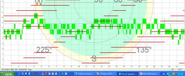
9 Satellites position in the celestial sphere. Continuous measurement on L1/L2. 9


10 Message, the target 10


11 Differential mode. RAIM thresholds. 11


12 Example of recording digital information. Measurements. Recorded binary frame. 09:07: эфемериды приняты для НКА ГЛОНАСС 15 t_b = e+04 SV_Helth =0x 0 IODC =0x 25 X = e+04 Y = e+04 Z = e+03 Vx = e-01 Vy = e-02 Vz = e+00 Ax = e-09 Ay = e-10 Az = e+00 gamma = e-12 tau = e-05 dtau = e-09 en = 0 09:07: эфемериды приняты для НКА GPS 10 Code_on_L2 =0x L2_P_flag =0x SV_accuracy =0x SV_Health =0x IODC =0x fit_interval_flag =0x Tgd = e-09 Toc = e+05 Af0 = e-05 Af1 = e-12 Af2 = e+00 e = e-02 dn = e-09 M0 = e-01 SqrtA = e+03 Toe = e+05 Omega0 = e+00 I0 = e-01 W = e-01 OmegaDot = e-09 IDOT = e-10 Cuc = e-06 Cus = e-06 Cic = e-08 Cis = e-08 Crc = e+02 Crs = e+01 12

; GPS (L1")
; COMPASS (L1 BOC 1,1); QZSS (L1 BOC")
, a")
13 Fixed equipment. Composition. 12 identical reconfigurable for different GNSS receivers in the eurorack : GLONASS (L1, L2, L3/L5, C/A, P, FDMA, CDMA); GPS (L1 C / A, L1C, L2C, L5); GALILEO (L1 E1, E5a, E5b); COMPASS (L1 BOC 1,1); QZSS (L1 BOC 1,1; L5 BPSK 10); SBAS (L1, L5). Antenna (omnidirectional, directional), a set of cables, laptop, Power Supplies. 13
14 Software of fixed equipment includes: Software of the fixed equipment. Software to predict orbital GNSS performances and their augmentations. Fixed equipment software structure is similar to the software for mobile GLONASS/GPS equipment. Also for other GNSS Real time software is similar to the software for mobile GLONASS/GPS equipment. Also for other GNSS Development of software for different GNSS signals depends on the interface control documents for these signals. Status of development. Eurorack is designed and manufactured. Receivers are designed and manufactured. Software is developed and aligned for GLONASS (L1, L2, C/A) and GPS (L1 C / A, L2C). 14
15 SQM monitoring of the GNSS navigation signals. Monitoring the quality of GNSS navigation signals performs the following functions: Аппаратура estimates spectral контроля characteristics качестваof навигационных the navigation signals; сигналов ГНСС выполняет estimates spectral and energy characteristics of the interference; displays and estimates the time characteristics of the navigation signals; estimates the energy characteristics of navigation signals. Composition of the equipment to control quality of GNSS navigation signals. Beam antenna diameter, d = 3.7 m, gain, K = 33 db. Antenna control system, monitoring antenna orientation system. Dedicated receiver. A high quality spectrum analyzer. Dedicated software. Laptop. 15


16 SQM. Fixed equipment 16
17 Distortion (1 st and 2 nd type) of a signal in time domain. τ δτ/τ = 0.1 δτ δτ/τ =
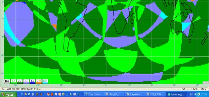
18 Spectrum distortion of GLONASS navigation signals on the L1 band 18
19 Modeling of navigation signal distortion. Simulation served to define basic parameters of a dedicated receiver. ADC. Δf in L1 band. ACF in the finite duration of the transition process. Δf in L5 L2 band. ACF at distortions of the 1st kind and band limited input signal. Number of points of the ACF. ACF view the perversions of the 1st kind and band limited input signal. View of ACF in the band 2 and a different change of duty cycle. 19
20 Experimental studies of navigation signals. Glonass M; 13, (f. = 2, ACF 128, date: 30 August 2012, L1 band. Point coordinates: 'N, 37 38' I (Moscow). GPS; 4, (ACF 128, date: 30 August 2012, L1 band. Point coordinates: 'N, 37 38' I (Moscow). 20
21 Experimental studies of navigation signals spectrum. Glonass-M 22 Band L1 Glonass -K; 21
22 Experimental studies of navigation signals spectrum. Band L2 Glonass-M 22 Glonass -K 22
23 Experimental studies of navigation signals spectrum. GPS 25 Band L3/L5 Glonass -K 23
24 Conclusions (1). 1. Compact (mobile) 64 channel equipment to control GLONASS/ GPS navigation signals on L1/L2 bands are designed, manufactured and operate. 2. Such equipment is especially useful in areas of testing mobile technique using the GLONASS/GPS satellite navigation device. It allows you optimally plan the tests and serve as a "referee" in conflict situations. 3. Fixed multi system navigation signals monitoring equipment can receive and process open signals of all (now known) GNSS and their augmentations. This allows you to compare and evaluate different GNSS options. The equipment is designed so that if any GNSS signal structure is modified, then it will be sufficient to reprogram the settings without changing the hardware. The equipment is manufactured. Currently, this equipment and software are being tested. 24
25 Conclusions (2). 4. Developed quality control system for GNSS navigation signals on the band of L1, L2 and L3/L5 allows: estimate modulating wave distortions : changing pulse bandwidth, presence of the transient process in the pulse bandwidth formation; estimate the level of the navigation signal near the ground; estimate the spectral characteristics of the signals; estimate interference conditions at the receiving point. 5. The state of SQM development: the equipment is manufactured; currently this equipment and software are being tested; calibration equipment for directional antenna is mounted.
26 Thank you for your attention 26
GNSS Signal Structures
 GNSS Signal Structures Tom Stansell Stansell Consulting Tom@Stansell.com Bangkok, Thailand 23 January 2018 S t a n s e l l C o n s u l t i n g RL Introduction It s a pleasure to speak with you this morning.
Introduction to Global Navigation Satellite System (GNSS) Signal Structure
 Signal Structure") Introduction to Global Navigation Satellite System (GNSS) Signal Structure Dinesh Manandhar Center for Spatial Information Science The University of Tokyo Contact Information: dinesh@iis.u-tokyo.ac.jp
Introduction to Global Navigation Satellite System (GNSS) Signal Structure Dinesh Manandhar Center for Spatial Information Science The University of Tokyo Contact Information: dinesh@iis.u-tokyo.ac.jp
DESIGN AND IMPLEMENTATION OF INTEGRATED GLOBAL NAVIGATION SATELLITE SYSTEM (GNSS) RECEIVER. B.Tech Thesis Report
 RECEIVER. B.Tech Thesis Report") Indian Institute of Technology Jodhpur DESIGN AND IMPLEMENTATION OF INTEGRATED GLOBAL NAVIGATION SATELLITE SYSTEM (GNSS) RECEIVER B.Tech Thesis Report Submitted by Arun Balajee V, Aswin Suresh and Mahesh
Indian Institute of Technology Jodhpur DESIGN AND IMPLEMENTATION OF INTEGRATED GLOBAL NAVIGATION SATELLITE SYSTEM (GNSS) RECEIVER B.Tech Thesis Report Submitted by Arun Balajee V, Aswin Suresh and Mahesh
III Satellite Ephemeris and Coordinates
 III Satellite Ephemeris and Coordinates Exercise III.1 Orbital Parameters Consider a satellite with the following orbital parameters orbit semi-major axis: A = 26559755m; orbit eccentricity: e = 0.017545;
Attitude Determination of Small Satellite: The GNSS Paradigm
 Attitude Determination of Small Satellite: The GNSS Paradigm Dr. Najam Abbas Naqvi Assistant Professor Department of Aeronautics and Astronautics Institute of Space Technology Islamabad, Pakistan Personal
Resection. We can measure direction in the real world! Lecture 10: Position Determination. Resection Example: Isola, Slovenia. Professor Keith Clarke
 Geography 12: Maps and Spatial Reasoning Lecture 10: Position Determination We can measure direction in the real world! Professor Keith Clarke Resection Resection Example: Isola, Slovenia Back azimuth
GPS (Introduction) References. Terms
 References. Terms") GPS (Introduction) WCOM2, GPS, 1 Terms NAVSTAR GPS ( Navigational Satellite Timing and Ranging - Global Positioning System) is a GNSS (Global Navigation Satellite System), developed by the US-DoD in 197x
GPS (Introduction) WCOM2, GPS, 1 Terms NAVSTAR GPS ( Navigational Satellite Timing and Ranging - Global Positioning System) is a GNSS (Global Navigation Satellite System), developed by the US-DoD in 197x
Sources of Error in Satellite Navigation Positioning
 http://www.transnav.eu the International Journal on Marine Navigation and Safety of Sea Transportation Volume 11 Number 3 September 2017 DOI: 10.12716/1001.11.03.04 Sources of Error in Satellite Navigation
The last 25 years - GPS to multi-gnss: from a military tool to the most widely used civilian positioning solution
 1 The last 25 years - GPS to multi-gnss: from a military tool to the most widely used civilian positioning solution B. Hofmann-Wellenhof Institute of Geodesy / Navigation, Graz University of Technology
Introduction to Global Navigation Satellite System (GNSS) Module: 1
 Module: 1") Introduction to Global Navigation Satellite System (GNSS) Module: 1 Dinesh Manandhar Center for Spatial Information Science The University of Tokyo Contact Information: dinesh@iis.u-tokyo.ac.jp Slide :
Introduction to Global Navigation Satellite System (GNSS) Module: 1 Dinesh Manandhar Center for Spatial Information Science The University of Tokyo Contact Information: dinesh@iis.u-tokyo.ac.jp Slide :
Benefits of amulti-gnss Receiver inaninterference Environment
 Benefits of amulti-gnss Receiver inaninterference Environment Ulrich Engel Fraunhofer Institute for Communication, Information Processing and Ergonomics FKIE Department Sensor Data and Information Fusion
King AbdulAziz University. Faculty of Environmental Design. Geomatics Department. Mobile GIS GEOM 427. Lecture 3
 King AbdulAziz University Faculty of Environmental Design Geomatics Department Mobile GIS GEOM 427 Lecture 3 Ahmed Baik, Ph.D. Email: abaik@kau.edu.sa Eng. Fisal Basheeh Email: fbasaheeh@kau.edu.sa GNSS
GPS (Introduction) References. Terms
 References. Terms") GPS (Introduction) MSE, Rumc, GPS, 1 Terms NAVSTAR GPS ( Navigational Satellite Timing and Ranging - Global Positioning System) is a GNSS (Global Navigation Satellite System), developed by the US-DoD in
GPS (Introduction) MSE, Rumc, GPS, 1 Terms NAVSTAR GPS ( Navigational Satellite Timing and Ranging - Global Positioning System) is a GNSS (Global Navigation Satellite System), developed by the US-DoD in
Design and Implementation of Global Navigation Satellite System (GNSS) Receiver. Final Presentation
 Receiver. Final Presentation") Design and Implementation of Global Navigation Satellite System (GNSS) Receiver Final Presentation Introduction Emerging applications of location based solutions automobiles, location based ads, emergency
Design and Implementation of Global Navigation Satellite System (GNSS) Receiver Final Presentation Introduction Emerging applications of location based solutions automobiles, location based ads, emergency
GNSS Accuracy Improvements through Multipath Mitigation with New Signals and services
 GNSS Accuracy Improvements through Multipath Mitigation with New Signals and services Andrey Veytsel, Ph.D Moscow Technical University 10 Meeting of the International Committee on Global Navigation Satellite
Understanding GPS/GNSS
 Understanding GPS/GNSS Principles and Applications Third Edition Contents Preface to the Third Edition Third Edition Acknowledgments xix xxi CHAPTER 1 Introduction 1 1.1 Introduction 1 1.2 GNSS Overview
FieldGenius Technical Notes GPS Terminology
 FieldGenius Technical Notes GPS Terminology Almanac A set of Keplerian orbital parameters which allow the satellite positions to be predicted into the future. Ambiguity An integer value of the number of
Principal Investigator Co-Principal Investigator Co-Principal Investigator Prof. Talat Ahmad Vice-Chancellor Jamia Millia Islamia Delhi
 Subject Paper No and Title Module No and Title Module Tag Geology Remote Sensing and GIS Concepts of Global Navigation Satellite RS & GIS XXXIII Principal Investigator Co-Principal Investigator Co-Principal
DYNAMIC POSITIONING CONFERENCE October 7-8, Sensors II. Redundancy in Dynamic Positioning Systems Based on Satellite Navigation
 Return to Session Directory DYNAMIC POSITIONING CONFERENCE October 7-8, 2008 Sensors II Redundancy in Dynamic Positioning Systems Based on Satellite Navigation Ole Ørpen, Tor Egil Melgård, Arne Norum Fugro
ICG WG-B Achievements on Interoperable GNSS Space Service Volume (SSV) November, 2016 Sochi, Russian Federation
 November, 2016 Sochi, Russian Federation") ICG WG-B Achievements on Interoperable GNSS Space Service Volume (SSV) November, 2016 Sochi, Russian Federation ICG WG-B Action Group on SSV Action group on SSV was formed within WG-B in order to Establish
ICG WG-B Achievements on Interoperable GNSS Space Service Volume (SSV) November, 2016 Sochi, Russian Federation ICG WG-B Action Group on SSV Action group on SSV was formed within WG-B in order to Establish
Future GNSS Precision Applications. Stuart Riley
 Future GNSS Precision Applications Stuart Riley Major Trimble Precision Markets Survey Mostly person portable equipment Construction Machine control and person carried equipment Includes Marine applications
Signal Structures for Satellite-Based Navigation: Past, Present, and Future*
 Signal Structures for Satellite-Based Navigation: Past, Present, and Future* John W. Betz 23 April 2013 *Approved for Public Release; Distribution Unlimited. 13-0908. The contents of this material reflect
GLONASS: Current status and perspectives
 Federal Space Agency GLONASS: Current status and perspectives 3rd ALLSAT Open conference Hannover, June 22, 2006 Vyacheslav DVORKIN, Sergey KARUTIN Russian Institute of Space Device Engineering 53, Aviamotornaya
System Status and Performance Improvement Prospects
 Communication Геодезия Navigation GLOBAL NAVIGATION SATELLITE SYSTEM (GLONASS): System Status and Performance Improvement Prospects Viktor KOSENKO, First Deputy General Designer First Deputy General Director
Configuring the Global Navigation Satellite System
 Configuring the Global Navigation Satellite System uses a satellite receiver, also called the global navigation satellite system (GNSS), as a new timing interface. In typical telecom networks, synchronization
Current status of Quasi-Zenith Satellite System. Japan Aerospace Exploration Agency QZSS Project Team
 Current status of Quasi-Zenith Satellite System Japan Aerospace Exploration Agency QZSS Project Team 1 Quasi-Zenith Satellite System The QZSS is a regional space-based PNT (Positioning, Navigation and
SDCM present status and future. GLONASS signals development.
 The Eighth Meeting of the International Committee on Global Navigation Satellite Systems, November 9 14, 2013, Dubai SDCM present status and future. GLONASS signals development. Prof. Grigory Stupak, Dr.
TEST YOUR SATELLITE NAVIGATION PERFORMANCE ON YOUR ANDROID DEVICE GLOSSARY
 TEST YOUR SATELLITE NAVIGATION PERFORMANCE ON YOUR ANDROID DEVICE GLOSSARY THE GLOSSARY This glossary aims to clarify and explain the acronyms used in GNSS and satellite navigation performance testing
Signals, and Receivers
 ENGINEERING SATELLITE-BASED NAVIGATION AND TIMING Global Navigation Satellite Systems, Signals, and Receivers John W. Betz IEEE IEEE PRESS Wiley CONTENTS Preface Acknowledgments Useful Constants List of
Russian Federation in GNSS Open Service Performance Parameters Template Creation
 Russian Federation in GNSS Open Service Performance Parameters Template Creation Bolkunov Alexey Russian Federal Space Agency Central Scientific-Research Institute for Machine building Information and
Experiences with Fugro's Real Time GPS/GLONASS Orbit/Clock Decimeter Level Precise Positioning System
 Return to Session Directory DYNAMIC POSITIONING CONFERENCE October 13-14, 2009 Sensors Experiences with Fugro's Real Time GPS/GLONASS Orbit/Clock Decimeter Level Precise Positioning System Ole Ørpen and
Indian GNSS Industry Overview Challenges and future prospects
 Indian GNSS Industry Overview Challenges and future prospects Expert Presentation By Dr. S.V. Kibe Consultant, SATCOM & GNSS, Bangalore, India (Former Programme Director, SATNAV,ISRO HQ) On February 20,2013
RESOLUTION MSC.401(95) (Adopted on 8 June 2015) PERFORMANCE STANDARDS FOR MULTI-SYSTEM SHIPBORNE RADIONAVIGATION RECEIVERS
 (Adopted on 8 June 2015) PERFORMANCE STANDARDS FOR MULTI-SYSTEM SHIPBORNE RADIONAVIGATION RECEIVERS") ANNEX 17 MSC 95/22/Add.2 Annex 17, page 1 THE MARITIME SAFETY COMMITTEE, RECALLING Article 28(b) of the Convention on the International Maritime Organization concerning the functions of the Committee,
ANNEX 17 MSC 95/22/Add.2 Annex 17, page 1 THE MARITIME SAFETY COMMITTEE, RECALLING Article 28(b) of the Convention on the International Maritime Organization concerning the functions of the Committee,
Improved Ephemeris Monitoring for GNSS
 Improved Ephemeris Monitoring for GNSS Todd Walter, Kazuma Gunning, and Juan Blanch Stanford University ABSTRACT GNSS performance monitoring is an important component of aviation safety. RAIM, SBAS, GBAS,
Future GNSS: Improved Signals and Constellations
 Future GNSS: Improved Signals and Constellations Guillermo Martínez Morán 1 1 Airbus Defense & Space. Paseo John Lennon s/n 28096 Getafe (Madrid Spain) Guillermo.M.Martinez@military.airbus.com Abstract:
Configuring the Global Navigation Satellite System
 Configuring the Global Navigation Satellite System Effective Cisco IOS-XE Release 3.17, the Cisco ASR-920-12SZ-IM router uses a satellite receiver, also called the global navigation satellite system (GNSS),
Challenges and Methods for Integrity Assurance in Future GNSS
 Challenges and Methods for Integrity Assurance in Future GNSS Igor Mozharov Division Head, Information and Analytical Center for PNT, Central Research Institute for Machine Building, Roscosmos igor.mozharov@mcc.rsa.ru
Configuring the Global Navigation Satellite System
 Configuring the Global Navigation Satellite System Effective Cisco IOS-XE Release 3.17, the Cisco ASR 903 (with RSP3 module) and Cisco ASR 907 router uses a satellite receiver, also called the global navigation
CH GPS/GLONASS/GALILEO/SBAS Signal Simulator. General specification Version 0.2 Eng. Preliminary
 CH-380 GPS/GLONASS/GALILEO/SBAS Signal Simulator General specification Version 0.2 Eng Preliminary Phone: +7 495 665 648 Fax: +7 495 665 649 navis@navis.ru NAVIS-UKRAINE Mazura str. 4 Smela, Cherkassy
Assessment of GNSS Ionospheric Scintillation and TEC Monitoring Using the Multi-constellation GPStation-6 Receiver
 Assessment of GNSS Ionospheric Scintillation and TEC Monitoring Using the Multi-constellation GPStation-6 Receiver Rod MacLeod Regional Manager Asia/Pacific NovAtel Australia Pty Ltd Outline Ionospheric
Configuring the Global Navigation Satellite System
 Configuring the Global Navigation Satellite System Effective Cisco IOS-XE Release 3.17, the Cisco ASR-920-12SZ-IM router uses a satellite receiver, also called the global navigation satellite system (GNSS),
Intro to GNSS & Teseo-LIV3F Module for IoT Positioning
 Intro to GNSS & Teseo-LIV3F Module for IoT Positioning Agenda 2 Presentation Speaker GPS Signal Overview GNSS Constellations Mike Slade Teseo3 Chipset Overview Multi-Constellation Benefit Teseo-LIV3F Module
GLONASS Status and Modernization
 GLONASS Status and Modernization Ekaterina Oleynik Central Research Institute of Roscosmos Federal Space Agency United Nations/Latvia Workshop on the Applications of Global Navigation Satellite Systems
Configuring the Global Navigation Satellite System
 Configuring the Global Navigation Satellite System Effective Cisco IOS-XE Release 3.17, the Cisco ASR-920-12SZ-IM router uses a satellite receiver, also called the global navigation satellite system (GNSS),
Brazil and Russia space cooperation: recent projects and future perspectives in the field of GNSS monitoring and SLR stations
 Brazil and Russia space cooperation: recent projects and future perspectives in the field of GNSS monitoring and SLR stations Renato A. Borges (UnB) and Geovany A. Borges (UnB) Emails: raborges@ene.unb.br
Bring satellites into your lab
 Bring satellites into your lab GNSS simulators from the T&M expert 5215.5042.32 02.01 PDP 1 en www.rohde-schwarz.com/gnss-solutions GNSS-Simulators--------Bring-satellites_fly_5215-5042-32_v0201.indd 7
Decoding Galileo and Compass
 Decoding Galileo and Compass Grace Xingxin Gao The GPS Lab, Stanford University June 14, 2007 What is Galileo System? Global Navigation Satellite System built by European Union The first Galileo test satellite
Dynamic Reconfiguration in a GNSS Software Defined Radio for Multi-Constellation Operation
 Dynamic Reconfiguration in a GNSS Software Defined Radio for Multi-Constellation Operation Alison K. Brown and D Arlyn Reed, NAVSYS Corporation BIOGRAPHY Alison Brown is the President and Chief Executive
Satellite-Based Augmentation System (SBAS) Integrity Services
 Integrity Services") Satellite-Based Augmentation System (SBAS) Integrity Services Presented To: Munich, Germany Date: March 8, 2010 By: Leo Eldredge, Manager GNSS Group, FAA FAA Satellite Navigation Program 2 Wide Area Augmentation
Satellite-Based Augmentation System (SBAS) Integrity Services Presented To: Munich, Germany Date: March 8, 2010 By: Leo Eldredge, Manager GNSS Group, FAA FAA Satellite Navigation Program 2 Wide Area Augmentation
IMO WORLD-WIDE RADIONAVIGATION SYSTEM (WWRNS) GALILEO receiver performance standards. Submitted by the European Commission
 GALILEO receiver performance standards. Submitted by the European Commission") INTERNATIONAL MARITIME ORGANIZATION E IMO SUB-COMMITTEE ON SAFETY OF NAVIGATION 50th session Agenda item 13 2 April 2004 Original: ENGLISH WORLD-WIDE RADIONAVIGATION SYSTEM (WWRNS) GALILEO receiver performance
INTERNATIONAL MARITIME ORGANIZATION E IMO SUB-COMMITTEE ON SAFETY OF NAVIGATION 50th session Agenda item 13 2 April 2004 Original: ENGLISH WORLD-WIDE RADIONAVIGATION SYSTEM (WWRNS) GALILEO receiver performance
PORTABLE GNSS MONITORING STATION (PGMS)
") SPACE PORTABLE GNSS MONITORING STATION (PGMS) Satellite communications, earth observation, navigation and positioning and control stations indracompany.com PORTABLE GNSS MONITORING STATION (PGMS) PORTABLE
SPACE PORTABLE GNSS MONITORING STATION (PGMS) Satellite communications, earth observation, navigation and positioning and control stations indracompany.com PORTABLE GNSS MONITORING STATION (PGMS) PORTABLE
Benefits and Limitations of New GNSS Signal Designs. Dr. A. J. Van Dierendonck AJ Systems, USA November 18, 2014
 Benefits and Limitations of New GNSS Signal Designs Dr. A. J. Van Dierendonck AJ Systems, USA November 18, 2014 My Opinions on New GNSS Signal Designs This briefing is loosely based upon Leadership Series
Challenges and Solutions for GPS Receiver Test
 Challenges and Solutions for GPS Receiver Test Presenter: Mirin Lew January 28, 2010 Agenda GPS technology concepts GPS and GNSS overview Assisted GPS (A-GPS) Basic tests required for GPS receiver verification
GLObal Navigation Satellite System (GLONASS)
") FEDERAL SPACE AGENCY GLObal Navigation Satellite System (GLONASS) Sergey Revnivykh Deputy Director General Central Research Institute of Machine Building Head of PNT Center 4-th meeting of International
FEDERAL SPACE AGENCY GLObal Navigation Satellite System (GLONASS) Sergey Revnivykh Deputy Director General Central Research Institute of Machine Building Head of PNT Center 4-th meeting of International
Precise Positioning with Smartphones running Android 7 or later
 Precise Positioning with Smartphones running Android 7 or later * René Warnant, * Cécile Deprez, + Quentin Warnant * University of Liege Geodesy and GNSS + Augmenteo, Plaine Image, Lille (France) Belgian
Supplement to. Global navigation satellite systems (GNSS) L E C T U R E. Zuzana Bělinová. TELEMATIC SYSTEMS AND THEIR DESIGN part Systems Lecture 5
 L E C T U R E. Zuzana Bělinová. TELEMATIC SYSTEMS AND THEIR DESIGN part Systems Lecture 5") Zuzana Bělinová L E C T U R E 5 Supplement to Global navigation satellite systems (GNSS) Recapitulation Satellite navigation systems Zuzana Bělinová History of satellite navigation USA USA 1960 TRANSIT
Zuzana Bělinová L E C T U R E 5 Supplement to Global navigation satellite systems (GNSS) Recapitulation Satellite navigation systems Zuzana Bělinová History of satellite navigation USA USA 1960 TRANSIT
Data Acquisition Experiment using NovAtel Dual Frequency GPS Receiver
 Data Acquisition Experiment using NovAtel Dual Frequency GPS Receiver Dhiraj Sunehra Jawaharlal Nehru Technological University Hyderabad, Andhra Pradesh, India Abstract The advent of very large scale integration
GNSS Conductor GF. User s Guide. (Document No. SE )
") GNSS Conductor GF User s Guide (Document No. ) www.furuno.com IMPORTANT NOTICE No part of this manual may be reproduced or transmitted in any form or by any means, electronic or mechanical, including photocopying
GNSS Conductor GF User s Guide (Document No. ) www.furuno.com IMPORTANT NOTICE No part of this manual may be reproduced or transmitted in any form or by any means, electronic or mechanical, including photocopying
What is it? History. Other systems. How does it work? Trilateration GEOG 201 4/28/2010. Instructor: Pesses 1. {06} The Global Positioning System
 What is it? {06} The Global Positioning System G.P.S. = Global Positioning System Different from G.I.S. (Geographic Information Systems) Map Interpretation & GPS Spring 2010 M. Pesses History Conceived
Monitoring Station for GNSS and SBAS
 Monitoring Station for GNSS and SBAS Pavel Kovář, Czech Technical University in Prague Josef Špaček, Czech Technical University in Prague Libor Seidl, Czech Technical University in Prague Pavel Puričer,
Benefits of combining systems The Receiver s Perspective Dr Philip G Mattos
 Benefits of combining systems The Receiver s Perspective Dr Philip G Mattos October 2011 Contents Who we are What s missing in GPS alone Other constellations available Improving GPS only receivers Add
BeiDou Space Service Volume Parameters and its Performance
 BeiDou Space Service Volume Parameters and its Performance Prof. Xingqun ZHAN, Shuai JING Shanghai Jiaotong University, China Xiaoliang WANG China Academy of Space Technology Contents 1 Background and
Global Navigation Satellite System for IE 5000
 Global Navigation Satellite System for IE 5000 Configuring GNSS 2 Information About GNSS 2 Guidelines and Limitations 4 Default Settings 4 Configuring GNSS 5 Configuring GNSS as Time Source for PTP 6 Verifying
Introduction to Geographic Information Science. Last Lecture. Today s Outline. Geography 4103 / GNSS/GPS Technology
 Geography 4103 / 5103 Introduction to Geographic Information Science GNSS/GPS Technology Last Lecture Geoids Ellipsoid Datum Projection Basics Today s Outline GNSS technology How satellite based navigation
BeiDou Next Generation Signal Design and Expected Performance
 International Technical Symposium on Navigation and Timing ENAC, 17 Nov 2015 BeiDou Next Generation Signal Design and Expected Performance Challenges and Proposed Solutions Zheng Yao Tsinghua University
GLOBAL POSITIONING SYSTEMS. Knowing where and when
 GLOBAL POSITIONING SYSTEMS Knowing where and when Overview Continuous position fixes Worldwide coverage Latitude/Longitude/Height Centimeter accuracy Accurate time Feasibility studies begun in 1960 s.
Performance Evaluation of Differential Global Navigation Satellite System with RTK Corrections
 IOSR Journal of Electronics and Communication Engineering (IOSR-JECE) e-issn: 2278-2834,p- ISSN: 2278-8735.Volume 9, Issue 2, Ver. VI (Mar - Apr. 2014), PP 43-47 Performance Evaluation of Differential
Fundamentals of GPS Navigation
 Fundamentals of GPS Navigation Kiril Alexiev 1 /76 2 /76 At the traditional January media briefing in Paris (January 18, 2017), European Space Agency (ESA) General Director Jan Woerner explained the knowns
GNSS MONITORING NETWORKS
 SPACE GNSS MONITORING NETWORKS Satellite communications, earth observation, navigation and positioning and control stations indracompany.com GNSS MONITORING NETWORKS GNSS MONITORING NETWORKS Indra s solutions
Asia Oceania Regional Workshop on GNSS Precise Point Positioning Experiment by using QZSS LEX
 Asia Oceania Regional Workshop on GNSS 2010 Precise Point Positioning Experiment by using QZSS LEX Tomoji TAKASU Tokyo University of Marine Science and Technology Contents Introduction of QZSS LEX Evaluation
Lecture-1 CHAPTER 2 INTRODUCTION TO GPS
 Lecture-1 CHAPTER 2 INTRODUCTION TO GPS 2.1 History of GPS GPS is a global navigation satellite system (GNSS). It is the commonly used acronym of NAVSTAR (NAVigation System with Time And Ranging) GPS (Global
GNSS Technologies. GNSS Acquisition Dr. Zahidul Bhuiyan Finnish Geospatial Research Institute, National Land Survey
 GNSS Acquisition 25.1.2016 Dr. Zahidul Bhuiyan Finnish Geospatial Research Institute, National Land Survey Content GNSS signal background Binary phase shift keying (BPSK) modulation Binary offset carrier
What is a GPS How does GPS work? GPS Segments GPS P osition Position Position Accuracy Accuracy Accuracy GPS A pplications Applications Applications
 What is GPS? What is a GPS How does GPS work? GPS Segments GPS Position Accuracy GPS Applications What is GPS? The Global Positioning System (GPS) is a precise worldwide radio-navigation system, and consists
The experimental evaluation of the EGNOS safety-of-life services for railway signalling
 Computers in Railways XII 735 The experimental evaluation of the EGNOS safety-of-life services for railway signalling A. Filip, L. Bažant & H. Mocek Railway Infrastructure Administration, LIS, Pardubice,
Comprehensive Study of GNSS Systems
 Quest Journals Journal of Software Engineering and Simulation Volume 3 ~ Issue 2 (2016) pp: 01-06 ISSN(Online) :2321-3795 ISSN (Print):2321-3809 www.questjournals.org Research Paper Comprehensive Study
Inertial Sensors. Ellipse 2 Series MINIATURE HIGH PERFORMANCE. Navigation, Motion & Heave Sensing IMU AHRS MRU INS VG
 Ellipse 2 Series MINIATURE HIGH PERFORMANCE Inertial Sensors IMU AHRS MRU INS VG ITAR Free 0.1 RMS Navigation, Motion & Heave Sensing ELLIPSE SERIES sets up new standard for miniature and cost-effective
Bring satellites into your lab: GNSS simulators from the T&M expert.
 Bring satellites into your lab: GNSS simulators from the T&M expert. www.rohde-schwarz.com/gnss-solutions Your challenge GNSS receiver tests can only be conclusive when they are performed under realistic
Global Navigation Satellite System (GLONASS): Status and Development
: Status and Development") Global Navigation Satellite System (GLONASS): Status and Development Tatiana Mirgorodskaya Information and Analysis Center for Positioning, Navigation and Timing Roscosmos State Corporation UN-Nepal Workshop
Global Navigation Satellite System (GLONASS): Status and Development Tatiana Mirgorodskaya Information and Analysis Center for Positioning, Navigation and Timing Roscosmos State Corporation UN-Nepal Workshop
Performance Evaluation of the Effect of QZS (Quasi-zenith Satellite) on Precise Positioning
 on Precise Positioning") Performance Evaluation of the Effect of QZS (Quasi-zenith Satellite) on Precise Positioning Nobuaki Kubo, Tomoko Shirai, Tomoji Takasu, Akio Yasuda (TUMST) Satoshi Kogure (JAXA) Abstract The quasi-zenith
Performance Evaluation of the Effect of QZS (Quasi-zenith Satellite) on Precise Positioning Nobuaki Kubo, Tomoko Shirai, Tomoji Takasu, Akio Yasuda (TUMST) Satoshi Kogure (JAXA) Abstract The quasi-zenith
Surveying in the Year 2020
 Surveying in the Year 2020 Johannes Schwarz Leica Geosystems My first toys 2 1 3 Questions Why is a company like Leica Geosystems constantly developing new surveying products and instruments? What surveying
Update on GPS L1C Signal Modernization. Tom Stansell Aerospace Consultant GPS Wing
 Update on GPS L1C Signal Modernization Tom Stansell Aerospace Consultant GPS Wing Glossary BOC = Binary Offset Carrier modulation C/A = GPS Coarse/Acquisition code dbw = 10 x log(signal Power/1 Watt) E1
Foreword by Glen Gibbons About this book Acknowledgments List of abbreviations and acronyms List of definitions
 Table of Foreword by Glen Gibbons About this book Acknowledgments List of abbreviations and acronyms List of definitions page xiii xix xx xxi xxv Part I GNSS: orbits, signals, and methods 1 GNSS ground
GNSS Training for ITS Developers. 1 - GNSS Principles
 GNSS Training for ITS Developers 1 - GNSS Principles Table of Content Introduction to Satellite Navigation Systems Basics on GNSS Receivers Galileo, the European GNSS EGNOS, the European Augmentation System
Errors in GPS. Errors in GPS. Geodetic Co-ordinate system. R. Khosla Fall Semester
 Errors in GPS Errors in GPS GPS is currently the most accurate positioning system available globally. Although we are talking about extreme precision and measuring distances by speed of light, yet there
GPS for. Land Surveyors. Jan Van Sickle. Fourth Edition. CRC Press. Taylor & Francis Group. Taylor & Francis Croup, an Informa business
 GPS for Land Surveyors Fourth Edition Jan Van Sickle CRC Press Taylor & Francis Group Boca Raton London New York CRC Press is an imprint of the Taylor & Francis Croup, an Informa business Contents Preface
The Impact of Performance Parameters over a DGPS Satellite Navigation System
 Australian Journal of Basic and Applied Sciences, 3(4): 4711-4719, 2009 ISSN 1991-8178 The Impact of Performance Parameters over a DGPS Satellite Navigation System 1 Madad Ali Shah, 2 Noor Ahmed Shaikh,
ASSEMBLY 37TH SESSION
 International Civil Aviation Organization WORKING PAPER A37-WP/195 1 22/9/10 (Information paper) ASSEMBLY 37TH SESSION TECHNICAL COMMISSION Agenda Item 35: The Global Air Traffic Management (ATM) System
High Precision Navigation Capabilities(L1-SAIF) and Applications Using Japanese Quasi-Zenith Satellite System (QZSS)
 and Applications Using Japanese Quasi-Zenith Satellite System (QZSS)") High Precision Navigation Capabilities(L1-SAIF) and Applications Using Japanese Quasi-Zenith Satellite System (QZSS) ICG WG-B Application SG Meeting Munich, Germany March 12, 2012 Satellite Positioning
High Precision Navigation Capabilities(L1-SAIF) and Applications Using Japanese Quasi-Zenith Satellite System (QZSS) ICG WG-B Application SG Meeting Munich, Germany March 12, 2012 Satellite Positioning
ICG 9 PRAGUE 10 November 2014
 ICG 9 PRAGUE 10 November 2014 GNSS and applications GNSS is technology powerfully enabler of a multitude of applications. Italy, recognizing that, have undertaken initiatives to develop pre-operational
GLONASS PROGRAMME UPDATE
 GLONASS PROGRAMME UPDATE Ivan Revnivykh Roscosmos State Space Corporation 11 th Meeting of the International Committee on Global Navigation Satellite System November 7, 2016 Sochi, Russian Federation CONTENTS
3GPP TS V9.1.0 ( )
") TS 37.571-5 V9.1.0 (2011-12) Technical Specification 3rd Generation Partnership Project; Technical Specification Group Radio Access Network; Universal Terrestrial Radio Access (UTRA) and Evolved UTRA (E-UTRA)
TS 37.571-5 V9.1.0 (2011-12) Technical Specification 3rd Generation Partnership Project; Technical Specification Group Radio Access Network; Universal Terrestrial Radio Access (UTRA) and Evolved UTRA (E-UTRA)
RESOLUTION MSC.233(82) (adopted on 5 December 2006) ADOPTION OF THE PERFORMANCE STANDARDS FOR SHIPBORNE GALILEO RECEIVER EQUIPMENT
 (adopted on 5 December 2006) ADOPTION OF THE PERFORMANCE STANDARDS FOR SHIPBORNE GALILEO RECEIVER EQUIPMENT") MSC 82/24/Add.2 RESOLUTION MSC.233(82) THE MARITIME SAFETY COMMITTEE, RECALLING Article 28(b) of the Convention on the International Maritime Organization concerning the functions of the Committee, RECALLING
MSC 82/24/Add.2 RESOLUTION MSC.233(82) THE MARITIME SAFETY COMMITTEE, RECALLING Article 28(b) of the Convention on the International Maritime Organization concerning the functions of the Committee, RECALLING
GPS and Recent Alternatives for Localisation. Dr. Thierry Peynot Australian Centre for Field Robotics The University of Sydney
 GPS and Recent Alternatives for Localisation Dr. Thierry Peynot Australian Centre for Field Robotics The University of Sydney Global Positioning System (GPS) All-weather and continuous signal system designed
Recommendation ITU-R M.1905 (01/2012)
") Recommendation ITU-R M.1905 (01/2012) Characteristics and protection criteria for receiving earth stations in the radionavigation-satellite service (space-to-earth) operating in the band 1 164-1 215 MHz
Recommendation ITU-R M.1905 (01/2012) Characteristics and protection criteria for receiving earth stations in the radionavigation-satellite service (space-to-earth) operating in the band 1 164-1 215 MHz
ETSI TS V ( )
") TS 137 571-5 V14.0.0 (2017-05) TECHNICAL SPECIFICATION Universal Mobile Telecommunications System (UMTS); LTE; Universal Terrestrial Radio Access (UTRA) and Evolved UTRA (E-UTRA) and Evolved Packet Core
TS 137 571-5 V14.0.0 (2017-05) TECHNICAL SPECIFICATION Universal Mobile Telecommunications System (UMTS); LTE; Universal Terrestrial Radio Access (UTRA) and Evolved UTRA (E-UTRA) and Evolved Packet Core
Developments in Satellite Navigation and Wireless Spectrum
 Developments in Satellite Navigation and Wireless Spectrum Chris Hegarty 14 June 2010 Christopher J. Hegarty, D.Sc. The MITRE Corporation chegarty@mitre.org 781-271-2127 (Tel) The contents of this material
Understanding GPS: Principles and Applications Second Edition
 Understanding GPS: Principles and Applications Second Edition Elliott Kaplan and Christopher Hegarty ISBN 1-58053-894-0 Approx. 680 pages Navtech Part #1024 This thoroughly updated second edition of an
Configuring the Global Navigation Satellite System
 Configuring the Global Navigation Satellite System First Published: November 30, 2015 Effective Cisco IOS-XE Release 3.17, the Cisco ASR 903 (with RSP3 module) and Cisco ASR 907 uter uses a satellite receiver,
Inertial Sensors. Ellipse Series MINIATURE HIGH PERFORMANCE. Navigation, Motion & Heave Sensing IMU AHRS MRU INS VG
 Ellipse Series MINIATURE HIGH PERFORMANCE Inertial Sensors IMU AHRS MRU INS VG ITAR Free 0.2 RMS Navigation, Motion & Heave Sensing ELLIPSE SERIES sets up new standard for miniature and cost-effective
Development of an Open Source Multi GNSS Data Processing Software
 2nd Asia Oceania Regional Workshop on GNSS 2010 Development of an Open Source Multi GNSS Data Processing Software Tomoji TAKASU Tokyo University of Marine Science and Technology Contents Introduction Issues