Presented at the FIG Congress 2018, May 6-11, 2018 in Istanbul, Turkey
|
|
|
- Roger Hood
- 5 years ago
- Views:
Transcription

1 Presented at the FIG Congress 2018, May 6-11, 2018 in Istanbul, Turkey
2 2 Improving Hydrographic PPP by Height Constraining Ashraf Abdallah (Egypt) Volker Schwieger, (Germany)
3 Content Motivation Concept of PPP technique Bernese GNSS Software Experimental data Implementation and Evaluation Conclusions 3

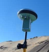
4 4 Motivation Hydrographic discipline is a major field of interest for positioning. 4 Highly accurate positioning of the objects on the water resources assists on: Plan, manage, and protect water resources Monitor the water resource Help on construction works Assure the water resource for navigation Hydrographic survey includes: Point positioning is obtained using GNSS technique. Water depth is obtained using Echo-sounder. [1]

![PPP solution: No need to a reference station One dual frequency instrument [2] 5 Egyptian Hydrographic survey Monitor the](/docs-images/96/126782600/images/5-2.jpg "sedimentation over the bed of Lake Nasser No reference station around Lake Nasser Lake Nasser extends for 330 km in Egypt and 160")
5 160 km in Sudan 330 km in Egypt GNSS point positioning technique: 1. Differential solution: Needs a known reference station Obtained by differencing the data between satellites and stations 2. PPP solution: No need to a reference station One dual frequency instrument [2] 5 Egyptian Hydrographic survey Monitor the sedimentation over the bed of Lake Nasser No reference station around Lake Nasser Lake Nasser extends for 330 km in Egypt and 160 km in Sudan PPP solution is a vital positioning solution in this case [3]

6 Concept of PPP technique Four error types have to be modelled or eliminated. Satellite Orbit & clock Satellite antenna phase centre 6 1. Satellite dependent errors [Satellite orbits, satellite clocks, and PCV for satellite antenna] 2. Atmosphere errors [Ionosphere and Troposphere] 3. Receiver dependent errors [Receiver clock error, PCV for receiver antenna, and multipath surround location] 4. Geophysical errors [solid earth tides, polar motion, ocean tide loading, and Earth rotation effect] Ionosphere model effect Troposphere model effect Receiver antenna phase centre Receiver clock error Multipath surrounding location [1]
7 Bernese GNSS software is a scientific, high quality geodetic software for post processing mode. It is developed at Astronomical Institute of the University of Bern (AIUB), Switzerland. It is used mainly by CODE center [Center for Orbit Determination in Europe]. It process the observation data for differential and PPP solution. Satellite orbits and clocks and earth orientation parameter are downloaded from CODE ftp server. Bernese GNSS Software 7
8 8 Orbit tools: generate satellite clock in processing format and prepare standard orbit file Pre-processing for RINEX files: smooth data from outliers and convert data to binary format Clock Synchronization: Receiver cock error estimation and create a code combination a priori file Parameter estimation: using least square adjustment. Two Loops for estimation: Parameter estimation
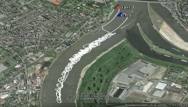
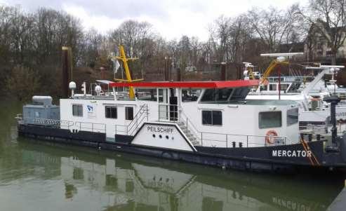
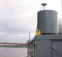
9 Experimental data 9 Rhine River data [two trajectories]
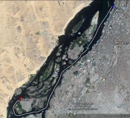
10 Experimental data Nile River data [One trajectory] 10
11 Implementation and Evaluation Land height profile is varying during moving. Hydrographic survey has the advantage that theoretically the water level is stable or varied with a small range. The idea of height constraining comes from this concept to improve the 2D positions of kinematic PPP solution. Height constraining is carried using Bernese software. Height profile for land Height profile for shallow water resource A priori kinematic file Extract Kinematic coordinates 11 Constrained solution No Yes Default solution Parameter estimation


12 Assumption of stability of water level HOW IT WORKS 12 Average 10 minuts (Lat., Long, ellips. height) Transform to Cartesian Create Apriori.KIN file Insert created.kin to Bernese Constrained height Constraining solution with defined sigma Compare epoch to epoch solution for position

13 Assumption of piecewise stability of water level HOW IT WORKS 13 Session detection

14 Assumption of piecewise stability of water level HOW IT WORKS 14 Session detection Constrained solution


15 RMS2D position (cm) Assumption of piecewise stability of water level HOW IT WORKS POSITION_ORG 7,2 4,7 First trajectory POSITION_CON 10,0 8,0 Second trajectory RMS2D position (cm)


16 RMS2D position (cm) Assumption of piecewise stability of water level HOW IT WORKS 16 POSITION_ORG , POSITION_CON 6,2 Default PPP and constrained height profile RMS2D position (cm)
17 Conclusions 17 Concept of stability of water level did not provide any improvement for 2Dposition. Piecewise stability of the height delivered an effective procedure to improve the 2Dposition. Rhine River: 20% - 35% Nile River: 16%
18 Thank you for your attention!
19 References [1]: Mills, J., Dodd, D. (2014): FIG Publication No. 62: Ellipsoidally Referenceed Surveying for Hydrography. Denmark: The International Fedration of Surveyors (FIG). [2]: Global-Positioning-System/, last access [3]: El Gammal, E., Salem, S., El Gammal, A. (2010): Change Detection Studies on the World's Biggest Artifitial Lake (Lake Nasser, Egypt). The Egyptian Journal of Remote Sensing and Space Sciences, 13. [4]: Center for Orbit Determination in Europe, Available at: last access on March 22, [5]: IGS (2015): International GNSS Service. Available at: last access on March 22,
GPS STATIC-PPP POSITIONING ACCURACY VARIATION WITH OBSERVATION RECORDING INTERVAL FOR HYDROGRAPHIC APPLICATIONS (ASWAN, EGYPT)
") GPS STATIC-PPP POSITIONING ACCURACY VARIATION WITH OBSERVATION RECORDING INTERVAL FOR HYDROGRAPHIC APPLICATIONS (ASWAN, EGYPT) Ashraf Farah Associate Professor,College of Engineering, Aswan University,
GPS STATIC-PPP POSITIONING ACCURACY VARIATION WITH OBSERVATION RECORDING INTERVAL FOR HYDROGRAPHIC APPLICATIONS (ASWAN, EGYPT) Ashraf Farah Associate Professor,College of Engineering, Aswan University,
Bernese GPS Software 4.2
 Bernese GPS Software 4.2 Introduction Signal Processing Geodetic Use Details of modules Bernese GPS Software 4.2 Highest Accuracy GPS Surveys Research and Education Big Permanent GPS arrays Commercial
International Journal of Scientific & Engineering Research, Volume 6, Issue 8, August ISSN
 International Journal of Scientific & Engineering Research, Volume 6, Issue 8, August-2015 683 Assessment Accuracy of Static Relative Positioning Using Single Frequency GPS Receivers Mahmoud I. El-Mewafi
Introduction to GNSS Base-Station
 Introduction to GNSS Base-Station Dinesh Manandhar Center for Spatial Information Science The University of Tokyo Contact Information: dinesh@iis.u-tokyo.ac.jp Slide : 1 Introduction GPS or GNSS observation
International Journal of Scientific & Engineering Research, Volume 7, Issue 12, December-2016
 International Journal of Scientific & Engineering Research, Volume 7, Issue 2, December-26 642 Enhancement of Precise Point Positioning Using GPS Single Frequency Data Ibrahim F. Shaker*, Tamer F. Fath-Allah**,
GPS for crustal deformation studies. May 7, 2009
 GPS for crustal deformation studies May 7, 2009 High precision GPS for Geodesy Use precise orbit products (e.g., IGS or JPL) Use specialized modeling software GAMIT/GLOBK GIPSY OASIS BERNESE These software
Precise Point Positioning (PPP) using
 using") Precise Point Positioning (PPP) using Product Technical Notes // May 2009 OnPOZ is a product line of Effigis. EZSurv is a registered trademark of Effigis. All other trademarks are registered or recognized
Precise Point Positioning (PPP) using Product Technical Notes // May 2009 OnPOZ is a product line of Effigis. EZSurv is a registered trademark of Effigis. All other trademarks are registered or recognized
AUSPOS GPS Processing Report
 AUSPOS GPS Processing Report February 13, 2012 This document is a report of the GPS data processing undertaken by the AUSPOS Online GPS Processing Service (version: AUSPOS 2.02). The AUSPOS Online GPS
Trimble Business Center:
 Trimble Business Center: Modernized Approaches for GNSS Baseline Processing Trimble s industry-leading software includes a new dedicated processor for static baselines. The software features dynamic selection
ION GNSS 2011 FILLING IN THE GAPS OF RTK WITH REGIONAL PPP
 ION GNSS 2011 FILLING IN THE GAPS OF RTK WITH REGIONAL PPP SEPTEMBER 22 th, 2011 ION GNSS 2011. PORTLAND, OREGON, USA SESSION F3: PRECISE POSITIONING AND RTK FOR CIVIL APPLICATION C. García A. Mozo P.
CODE. L. Prange, R. Dach, S. Schaer, S. Lutz, A. Jäggi
 source: https://doi.org/10.7892/boris.44252 downloaded: 13.3.2017 Experiences with IGS MGEX data analysis at CODE. L. Prange, R. Dach, S. Schaer, S. Lutz, A. Jäggi Astronomical Institute, University of
magicgnss: QUALITY DATA, ALGORITHMS AND PRODUCTS FOR THE GNSS USER COMMUNITY
 SEMANA GEOMATICA 2009 magicgnss: QUALITY DATA, ALGORITHMS AND PRODUCTS FOR THE GNSS USER COMMUNITY MARCH 3, 2009 BARCELONA, SPAIN SESSION: GNSS PRODUCTS A. Mozo P. Navarro R. Píriz D. Rodríguez March 3,
Principles of the Global Positioning System Lecture 20" Processing Software" Primary research programs"
 12.540 Principles of the Global Positioning System Lecture 20" Prof. Thomas Herring" Room 54-820A; 253-5941" tah@mit.edu" http://geoweb.mit.edu/~tah/12.540 " Processing Software" Examine basic features
GNSS & Coordinate Systems
 GNSS & Coordinate Systems Matthew McAdam, Marcelo Santos University of New Brunswick, Department of Geodesy and Geomatics Engineering, Fredericton, NB May 29, 2012 Santos, 2004 msantos@unb.ca 1 GNSS GNSS
GNSS Technologies. PPP and RTK
 PPP and RTK 29.02.2016 Content Carrier phase based positioning PPP RTK VRS Slides based on: GNSS Applications and Methods, by S. Gleason and D. Gebre-Egziabher (Eds.), Artech House Inc., 2009 http://www.gnssapplications.org/
VARIATION OF STATIC-PPP POSITIONING ACCURACY USING GPS-SINGLE FREQUENCY OBSERVATIONS (ASWAN, EGYPT)
") ARTIFICIAL SATELLITES, Vol. 52, No. 2 2017 DOI: 10.1515/arsa-2017-0003 VARIATION OF STATIC-PPP POSITIONING ACCURACY USING GPS-SINGLE FREQUENCY OBSERVATIONS (ASWAN, EGYPT) Ashraf Farah Associate professor,
ARTIFICIAL SATELLITES, Vol. 52, No. 2 2017 DOI: 10.1515/arsa-2017-0003 VARIATION OF STATIC-PPP POSITIONING ACCURACY USING GPS-SINGLE FREQUENCY OBSERVATIONS (ASWAN, EGYPT) Ashraf Farah Associate professor,
Precise Positioning GNSS Applications
 Precise Point Positioning: Is the Era of Differential GNSS Positioning Drawing to an End? School of Surveying & Spatial Information Systems, UNSW, Sydney, Australia Chris Rizos 1, Volker Janssen 2, Craig
PERSPECTIVES OF FREE GNSS POST-PROCESSING SOFTWARE USING
 XIII International forum «INTEREXPO GEO-Siberia 2017» PERSPECTIVES OF FREE GNSS POST-PROCESSING SOFTWARE USING S. Shevchuk, L. Lipatnikov, K. Malyutina (Siberian State University of Geosystems and Technologies)
Towards a EUREF Service Providing Real-time GNSS Clock and Orbit Corrections
 Towards a EUREF Service Providing Real-time GNSS Clock and Orbit Corrections G. Weber 1), W. Söhne 1), A. Stürze 1), L. Mervart 2) 1) Federal Agency for Cartography and Geodesy, Frankfurt am Main, Germany
Kinematic Precise Point Positioning (PPP) Solution for Hydrographic Applications
 Solution for Hydrographic Applications") Kinematic Precise Point Positioning (PPP) Solution for Hydrographic Applications Ashraf ABDALLAH and Volker SCHWIEGER, Germany Keywords: Kinematic GNSS-PPP, Hydrographic Applications, Bernese Software
Kinematic Precise Point Positioning (PPP) Solution for Hydrographic Applications Ashraf ABDALLAH and Volker SCHWIEGER, Germany Keywords: Kinematic GNSS-PPP, Hydrographic Applications, Bernese Software
Keywords: GPS/GLONASS, Precise Point Positioning, Kinematic, Hydrography
 GPS/GLONASS COMBINED PRECISE POINT POSITIOINING FOR HYDROGRAPHY CASE STUDY (ASWAN, EGYPT) Ashraf Farah Associate Professor,College of Engineering, Aswan University, Egypt, ashraf_farah@aswu.edu.eg ABSTRACT
Guochang Xu GPS. Theory, Algorithms and Applications. Second Edition. With 59 Figures. Sprin ger
 Guochang Xu GPS Theory, Algorithms and Applications Second Edition With 59 Figures Sprin ger Contents 1 Introduction 1 1.1 AKeyNoteofGPS 2 1.2 A Brief Message About GLONASS 3 1.3 Basic Information of Galileo
IGS Products for the Ionosphere
 1 IGS Products for the Ionosphere J. Feltens 1 and S. Schaer 2 1. EDS at Flight Dynamics Division, ESA, European Space Operations Centre, Robert-Bosch-Str. 5, D-64293 Darmstadt, Germany 2. Astronomical
Advances in GNSS Technology and it s Application to Tidal Derivation
 Advances in GNSS Technology and it s Application to Tidal Derivation Tim Painter Chief Surveyor Fugro Survey Africa Pty Ltd John Vint Survey and Starfix Product Manager Fugro Survey AS, Norway Scope of
Multisystem Real Time Precise-Point-Positioning, today with GPS+GLONASS in the near future also with QZSS, Galileo, Compass, IRNSS
 2 International Symposium on /GNSS October 26-28, 2. Multisystem Real Time Precise-Point-Positioning, today with +GLONASS in the near future also with QZSS, Galileo, Compass, IRNSS Álvaro Mozo García,
Precise Point Positioning Developments at GSD: Products, Services
 Precise Point Positioning Developments at GSD: Products, Services F. Lahaye, P. Collins, Y. Mireault, P. Tétreault, M. Caissy Geodetic Survey Division, Natural Resources Canada (NRCan) GEOIDE - PPP Workshop
Wednesday AM: (Doug) 2. PS and Long Period Signals
 2. PS and Long Period Signals") Wednesday AM: (Doug) 2 PS and Long Period Signals What is Colorado famous for? 32 satellites 12 Early on in the world of science synchronization of clocks was found to be important. consider Paris: puffs
Wednesday AM: (Doug) 2 PS and Long Period Signals What is Colorado famous for? 32 satellites 12 Early on in the world of science synchronization of clocks was found to be important. consider Paris: puffs
Comparative analysis of GNSS Real Time Kinematic methods for navigation
 IAV Hassan II Comparative analysis of GNSS Real Time Kinematic methods for navigation Mourad BOUZIANI School of Geomatic Sciences, IAV Hassan II, Rabat, Morocco. Coordinator of the Master - GNSS, IAV&
Simulation Analysis for Performance Improvements of GNSS-based Positioning in a Road Environment
 Simulation Analysis for Performance Improvements of GNSS-based Positioning in a Road Environment Nam-Hyeok Kim, Chi-Ho Park IT Convergence Division DGIST Daegu, S. Korea {nhkim, chpark}@dgist.ac.kr Soon
AOS STUDIES ON USE OF PPP TECHNIQUE FOR TIME TRANSFER
 AOS STUDIES ON USE OF PPP TECHNIQUE FOR TIME TRANSFER P. Lejba, J. Nawrocki, D. Lemański, and P. Nogaś Space Research Centre, Astrogeodynamical Observatory (AOS), Borowiec, ul. Drapałka 4, 62-035 Kórnik,
Presentation Plan. The Test of Processing Modules of Global Positioning System (GPS) Softwares by Using Products of International GPS Service (IGS)
 Softwares by Using Products of International GPS Service (IGS)") The Test of Processing Modules of Global Positioning System (GPS) Softwares by Using Products of International GPS Service (IGS) Presentation Plan 1. Introduction 2. Application 3. Conclusions Ismail SANLIOGLU,
The Test of Processing Modules of Global Positioning System (GPS) Softwares by Using Products of International GPS Service (IGS) Presentation Plan 1. Introduction 2. Application 3. Conclusions Ismail SANLIOGLU,
MINOS Timing and GPS Precise Point Positioning
 MINOS Timing and GPS Precise Point Positioning Stephen Mitchell US Naval Observatory stephen.mitchell@usno.navy.mil for the International Workshop on Accelerator Alignment 2012 in Batavia, IL A Joint
Accuracy assessment of free web-based online GPS Processing services and relative GPS solution software
 82 Accuracy assessment of free web-based online GPS Processing services and relative GPS solution software Khaled Mahmoud Abdel Aziz Department of Surveying Engineering, Shoubra Faculty of Engineering,
Salient Feature of ITRF. Realization of Dubai Emirate Datum. Reference Frame 2000 (Ditr 2000)
") Salient Feature of ITRF on the Reference Frame 2000 (Ditr 2000) ITRF stands for International Terrestrial Reference Frame ITRF established by the International Earth Rotation Service (IERS), France. One
Salient Feature of ITRF on the Reference Frame 2000 (Ditr 2000) ITRF stands for International Terrestrial Reference Frame ITRF established by the International Earth Rotation Service (IERS), France. One
Principles of the Global Positioning System Lecture 19
 12.540 Principles of the Global Positioning System Lecture 19 Prof. Thomas Herring http://geoweb.mit.edu/~tah/12.540 GPS Models and processing Summary: Finish up modeling aspects Rank deficiencies Processing
Performance Evaluation Of Real Time Precise Point Positioning (RT-PPP) In Static & Kinematic Modes In Egypt
 In Static & Kinematic Modes In Egypt") Performance Evaluation Of Real Time Precise Point Positioning (RT-PPP) In Static & Kinematic Modes In Egypt Eng. Ahmed Mansour Abdallah Dr. Mahmoud Abd Rabbou Prof. Adel El.shazly Geomatic Branch, Civil
Performance Evaluation Of Real Time Precise Point Positioning (RT-PPP) In Static & Kinematic Modes In Egypt Eng. Ahmed Mansour Abdallah Dr. Mahmoud Abd Rabbou Prof. Adel El.shazly Geomatic Branch, Civil
Assessment of the Accuracy of Processing GPS Static Baselines Up To 40 Km Using Single and Dual Frequency GPS Receivers.
 International OPEN ACCESS Journal Of Modern Engineering Research (IJMER) Assessment of the Accuracy of Processing GPS Static Baselines Up To 40 Km Using Single and Dual Frequency GPS Receivers. Khaled
MGEX Clock Determination at CODE
 source: http://boris.unibe.ch/74079/ downloaded: 13.3.2017 MGEX Clock Determination at CODE E. Orliac, L. Prange, R. Dach, S. Schaer and A. Jäggi Astronomical Institute of University of Bern (AIUB) Bern,
TREATMENT OF DIFFRACTION EFFECTS CAUSED BY MOUNTAIN RIDGES
 TREATMENT OF DIFFRACTION EFFECTS CAUSED BY MOUNTAIN RIDGES Rainer Klostius, Andreas Wieser, Fritz K. Brunner Institute of Engineering Geodesy and Measurement Systems, Graz University of Technology, Steyrergasse
Ship-based Oceanwide Observation of Sea Surface Heights in Consideration of Hydrodynamic Corrections
 Ship-based Oceanwide Observation of Sea Surface Heights in Consideration of Hydrodynamic Corrections Jörg Reinking, Alexander Härting XXV FIG Congress 2014, Kuala Lumpur, 16-21 June 2014 MOTIVATION Sea
Increasing PPP Accuracy Using Permanent Stations Corrections
 International Journal of Engineering and Advanced Technology (IJEAT) Increasing PPP Accuracy Using Permanent Stations Corrections Ibrahim F. Shaker, Tamer F. Fath-Allah, Mohamed M. El-Habiby, Ahmed E.
What makes the positioning infrastructure work. Simon Kwok Chairman, Land Surveying Division Hong Kong Institute of Surveyors
 What makes the positioning infrastructure work The experience of the Hong Kong Satellite Positioning Reference Station Network Simon Kwok Chairman, Land Surveying Division Hong Kong Institute of Surveyors
CGG. Office of the Surveyor General of the Federation Federal Capital Territory, Abuja, Nigeria 2
 Prof. P. C. Nwilo 1, * Dr. J. D. Dodo 2, U. R. Edozie 1, and A. Adebomehin 1. 1 Office of the Surveyor General of the Federation Federal Capital Territory, Abuja, Nigeria 2 Centre for Geodesy and Geodynamics,
Convergence Time Improvement of Precise Point Positioning
 , Canada Key words: GPS, Precise Point Positioning, satellite orbit, clock corrections, ionosphere SUMMARY Presently, precise point positioning (PPP) requires about 30 minutes or more to achieve centimetreto
COMPARISON OF GPS COMMERCIAL SOFTWARE PACKAGES TO PROCESSING STATIC BASELINES UP TO 30 KM
 COMPARISON OF GPS COMMERCIAL SOFTWARE PACKAGES TO PROCESSING STATIC BASELINES UP TO 30 KM Khaled Mohamed Abdel Mageed Civil Engineering, Cairo, Egypt E-Mail: khaled_mgd@yahoo.com ABSTRACT The objective
Effect of Differential Code Biases on the GPS CORS Network: A Case Study of Egyptian Permanent GPS Network (EPGN)
") Effect of Differential Code Biases on the GPS CORS Network: A Case Study of Egyptian Permanent GPS Network (EPGN) Mohammed A. Abid 1, 2*, Ashraf Mousa 3, Mostafa Rabah 4, Mahmoud El mewafi 1, and Ahmed
Effect of Differential Code Biases on the GPS CORS Network: A Case Study of Egyptian Permanent GPS Network (EPGN) Mohammed A. Abid 1, 2*, Ashraf Mousa 3, Mostafa Rabah 4, Mahmoud El mewafi 1, and Ahmed
RTCM-SSR Strategy of Bias Treatment
 RTCM-SSR Strategy of Bias Treatment Gerhard Wübbena Geo++ GmbH 30827 Garbsen Germany www.geopp.de Chair of RTCM-SSR WG www.rtcm.org RTCM-SC104 SSR Development working group established in 2007 3 message
Modelling GPS Observables for Time Transfer
 Modelling GPS Observables for Time Transfer Marek Ziebart Department of Geomatic Engineering University College London Presentation structure Overview of GPS Time frames in GPS Introduction to GPS observables
GNSS orbits and ERPs from CODE s repro2 solutions
 GNSS orbits and ERPs from CODE s repro2 solutions S. Lutz 1, P. Steigenberger 2, G. Beutler 1, S. Schaer 3, R. Dach 1, A. Jäggi 1 1 Astronomical Institute of the University of Bern, Bern, Switzerland 2
FieldGenius Technical Notes GPS Terminology
 FieldGenius Technical Notes GPS Terminology Almanac A set of Keplerian orbital parameters which allow the satellite positions to be predicted into the future. Ambiguity An integer value of the number of
Influence of network geometry on densification on the Faroe Islands 2011
 Influence of network geometry on densification on the Faroe Islands 2011 Shfaqat Abbas Khan 1, Mette Weber 2, Karsten Enggaard Engsager 1,2, and Per Knudsen 1 1 Department of Geodesy, National Space Institute
The Benefit of Triple Frequency on Cycle Slip Detection
 Presented at the FIG Congress 2018, The Benefit of Triple Frequency on Cycle Slip Detection May 6-11, 2018 in Istanbul, Turkey Dong Sheng Zhao 1, Craig Hancock 1, Gethin Roberts 2, Lawrence Lau 1 1 The
Connecting a Cadastral Survey to PNG94 using GNSS
 43rd Association of Surveyors PNG Congress, Lae, 12th-15th August 2009 Connecting a Cadastral Survey to PNG94 using GNSS Richard Stanaway QUICKCLOSE Workshop overview Legal requirements to connect surveys
Impact of GLONASS in a rigorous combination with GPS
 Fakultät Umweltwissenschaften Professur für Geodätische Erdsystemforschung source: https://doi.org/10.7892/boris.44677 downloaded: 13.3.2017 Session 1.2a Strength, Weakness, Modeling Standards and Processing
Global Positioning System: what it is and how we use it for measuring the earth s movement. May 5, 2009
 Global Positioning System: what it is and how we use it for measuring the earth s movement. May 5, 2009 References Lectures from K. Larson s Introduction to GNSS http://www.colorado.edu/engineering/asen/
Global Products for GPS Point Positioning Approaching Real-Time
 Global Products for GPS Point Positioning Approaching Real-Time Y. Gao 1, P. Heroux 2 and M. Caissy 2 1 Department of Geomatics Engineering, University of Calgary 2 Geodetic Survey Division, Natural Resources
Bernhard Hofnlann-Wellenhof Herbert Lichtenegger Elmar Wasle. GNSS - Global Navigation Satellite Systenls. GPS, GLONASS, Galileo, and nl0re
 Bernhard Hofnlann-Wellenhof Herbert Lichtenegger Elmar Wasle GNSS - Global Navigation Satellite Systenls GPS, GLONASS, Galileo, and nl0re SpringerWienNewYork Contents Abbreviations xxi 1 Introduction 1
An Introduction to GPS
 An Introduction to GPS You are here The GPS system: what is GPS Principles of GPS: how does it work Processing of GPS: getting precise results Yellowstone deformation: an example What is GPS? System to
Influence of GPS Measurements Quality to NTP Time-Keeping
 Influence of GPS Measurements Quality to NTP Time-Keeping Vukan Ogrizović 1, Jelena Gučević 2, Siniša Delčev 3 1 +381 11 3218 582, fax: +381113370223, e-mail: vukan@grf.bg.ac.rs 2 +381 11 3218 538, fax:
MONITORING SEA LEVEL USING GPS
 38 MONITORING SEA LEVEL USING GPS Hasanuddin Z. Abidin* Abstract GPS (Global Positioning System) is a passive, all-weather satellite-based navigation and positioning system, which is designed to provide
CHAPTER 2 GPS GEODESY. Estelar. The science of geodesy is concerned with the earth by quantitatively
 CHAPTER 2 GPS GEODESY 2.1. INTRODUCTION The science of geodesy is concerned with the earth by quantitatively describing the coordinates of each point on the surface in a global or local coordinate system.
Precise Positioning with NovAtel CORRECT Including Performance Analysis
 Precise Positioning with NovAtel CORRECT Including Performance Analysis NovAtel White Paper April 2015 Overview This article provides an overview of the challenges and techniques of precise GNSS positioning.
Geodetic Reference Frame Theory
 Technical Seminar Reference Frame in Practice, Geodetic Reference Frame Theory and the practical benefits of data sharing Geoffrey Blewitt University of Nevada, Reno, USA http://geodesy.unr.edu Sponsors:
Precise Positioning with Smartphones running Android 7 or later
 Precise Positioning with Smartphones running Android 7 or later * René Warnant, * Cécile Deprez, + Quentin Warnant * University of Liege Geodesy and GNSS + Augmenteo, Plaine Image, Lille (France) Belgian
GNSS Technologies. PPP and RTK
 PPP and RTK 22.03.2017 Content Carrier phase based positioning PPP RTK VRS Slides based on: GNSS Applications and Methods, by S. Gleason and D. Gebre-Egziabher (Eds.), Artech House Inc., 2009 http://www.gnssapplications.org/
Sub-daily signals in GPS. at semi-annual and annual periods
 Sub-daily signals in GPS observations and their effect at semi-annual and annual periods Matt King1 Chris Watson2, Nigel Penna1 Newcastle University, UK 2 University of Tasmania, Australia 1 Propagation
NASDA S PRECISE ORBIT DETERMINATION SYSTEM
 NASDA S PRECISE ORBIT DETERMINATION SYSTEM Maki Maeda Takashi Uchimura, Akinobu Suzuki, Mikio Sawabe National Space Development Agency of Japan (NASDA) Sengen 2-1-1, Tsukuba, Ibaraki, 305-8505, JAPAN E-mail:
GPS for. Land Surveyors. Jan Van Sickle. Fourth Edition. CRC Press. Taylor & Francis Group. Taylor & Francis Croup, an Informa business
 GPS for Land Surveyors Fourth Edition Jan Van Sickle CRC Press Taylor & Francis Group Boca Raton London New York CRC Press is an imprint of the Taylor & Francis Croup, an Informa business Contents Preface
Multi-Constellation GNSS Precise Point Positioning using GPS, GLONASS and BeiDou in Australia
 International Global Navigation Satellite Systems Society IGNSS Symposium 2015 Multi-Constellation GNSS Precise Point Positioning using GPS, GLONASS and BeiDou in Australia Xiaodong Ren 1,Suelynn Choy
Connecting a Survey to PNG94 and MSL using GNSS
 45th Association of Surveyors PNG Congress, Madang, 19-22 July 2011 Connecting a Survey to PNG94 and MSL using GNSS Richard Stanaway QUICKCLOSE Workshop overview Legal requirements to connect surveys to
GNSS Ionosphere Analysis at CODE
 GNSS Ionosphere Analysis at CODE Stefan Schaer 2004 IGS Workshop Berne, Switzerland March 1-5 Time Series of Global Mean TEC Covering Nearly One Solar Cycle as Generated at CODE 1 Exceptionally High TEC
Application of GNSS Methods for Monitoring Offshore Platform Deformation
 Application of GNSS Methods for Monitoring Offshore Platform Deformation Khin Cho Myint 1,*, Abd Nasir Matori 1, and Adel Gohari 1 1 Department of Civil and Environmental Engineering, Universiti Teknologi
Determination of Regional TEC Values by GNSS Measurements, A Case Study: Central Anatolia Sample, Turkey
 Presented at the FIG Working Week 2017, May 29 - June 2, 2017 in Helsinki, Finland Determination of Regional TEC Values by GNSS Measurements, A Case Study: Central Anatolia Sample, Turkey Fuat BAŞÇİFTÇİ,
Kalman Filter Based Integer Ambiguity. Ionosphere and Troposphere Estimation
 ION GNSS 2010 Kalman Filter Based Integer Ambiguity Resolution Strategy t for Long Baseline RTK with Ionosphere and Troposphere Estimation Tokyo University of Marine Science and Technology Tomoji jitakasu
Clock Synchronization of Pseudolite Using Time Transfer Technique Based on GPS Code Measurement
 , pp.35-40 http://dx.doi.org/10.14257/ijseia.2014.8.4.04 Clock Synchronization of Pseudolite Using Time Transfer Technique Based on GPS Code Measurement Soyoung Hwang and Donghui Yu* Department of Multimedia
Integer Ambiguity Resolution for Precise Point Positioning Patrick Henkel
 Integer Ambiguity Resolution for Precise Point Positioning Patrick Henkel Overview Introduction Sequential Best-Integer Equivariant Estimation Multi-frequency code carrier linear combinations Galileo:
Foreword by Glen Gibbons About this book Acknowledgments List of abbreviations and acronyms List of definitions
 Table of Foreword by Glen Gibbons About this book Acknowledgments List of abbreviations and acronyms List of definitions page xiii xix xx xxi xxv Part I GNSS: orbits, signals, and methods 1 GNSS ground
Table of Contents. Frequently Used Abbreviation... xvii
 GPS Satellite Surveying, 2 nd Edition Alfred Leick Department of Surveying Engineering, University of Maine John Wiley & Sons, Inc. 1995 (Navtech order #1028) Table of Contents Preface... xiii Frequently
RTCM State Space Representation (SSR) Overall Concepts Towards PPP-RTK
 Overall Concepts Towards PPP-RTK") RTCM State Space Representation (SSR) Overall Concepts Towards PPP-RTK Gerhard Wübbena Geo++ GmbH 30827 Garbsen Germany www.geopp.de Contents Terms and Abbreviations RTCM-SSR Working Group GNSS Error Sources
RTCM State Space Representation (SSR) Overall Concepts Towards PPP-RTK Gerhard Wübbena Geo++ GmbH 30827 Garbsen Germany www.geopp.de Contents Terms and Abbreviations RTCM-SSR Working Group GNSS Error Sources
Federico MORSUT 1, Raffaela CEFALO 2. DMG, University of Trieste; 2 GeoSNav Lab, University of Trieste
 Comparison between PPP and DD processing techniques using Bernese 5.2 Computation of displacements and velocities of Marussi FVG and FredNet GNSS networks and visualization on GeoServer: first results
ABSTRACT: Three types of portable units with GNSS raw data recording capability are assessed to determine static and kinematic position accuracy
 ABSTRACT: Three types of portable units with GNSS raw data recording capability are assessed to determine static and kinematic position accuracy under various environments using alternatively their internal
GNSS Low-Cost High-Accuracy Receiver (L-CHAR)
") GNSS Low-Cost High-Accuracy Receiver (L-CHAR) Dinesh Manandhar Center for Spatial Information Science The University of Tokyo Contact Information: dinesh@iis.u-tokyo.ac.jp Slide : 1 High Accuracy Receivers
GNSS Low-Cost High-Accuracy Receiver (L-CHAR) Dinesh Manandhar Center for Spatial Information Science The University of Tokyo Contact Information: dinesh@iis.u-tokyo.ac.jp Slide : 1 High Accuracy Receivers
Integrated geodetic infrastructure at the Geodetic Observatory Pecný, Czech Republic, in service of national and international GNSS projects
 Integrated geodetic infrastructure at the Geodetic Observatory Pecný, Czech Republic, in service of national and international GNSS projects Pavel NOVÁK, Czech Republic Key words: geodesy, reference systems,
Carrier Phase Multipath Corrections Based on GNSS Signal Quality Measurements to Improve CORS Observations
 Carrier Phase Multipath Corrections Based on GNSS Signal Quality Measurements to Improve CORS Observations Christian Rost and Lambert Wanninger Geodetic Institute Technische Universität Dresden Dresden,
From Passive to Active Control Point Networks Evaluation of Accuracy in Static GPS Surveying
 From Passive to Active Control Point Networks Evaluation of Accuracy in Static GPS Surveying P. Häkli 1, U. Kallio 1 and J. Puupponen 2 1) Finnish Geodetic Institute 2) National Land Survey of Finland
THE INFLUENCE OF ZENITH TROPOSPHERIC DELAY ON PPP-RTK. S. Nistor a, *, A.S. Buda a,
 THE INFLUENCE OF ZENITH TROPOSPHERIC DELAY ON PPP-RTK S. Nistor a, *, A.S. Buda a, a University of Oradea, Faculty of Civil Engineering, Cadastre and Architecture, Department Cadastre-Architecture, Romania,
Detection of Abnormal Ionospheric Activity from the EPN and Impact on Kinematic GPS positioning
 Detection of Abnormal Ionospheric Activity from the EPN and Impact on Kinematic GPS positioning N. Bergeot, C. Bruyninx, E. Pottiaux, S. Pireaux, P. Defraigne, J. Legrand Royal Observatory of Belgium Introduction
SPEEDING UP FILTER CONVERGENCE IN HIGH PRECISION, VERY LARGE AREA KINEMATIC NAVIGATION
 IMA HOT TOPICS WORKSHOP: Mathematical Challenges in Global Positioning Systems (GPS) University of Minnessota, 16-19 August 2000 SPEEDING UP FILTER CONVERGENCE IN HIGH PRECISION, VERY LARGE AREA KINEMATIC
Fundamentals of GPS for high-precision geodesy
 Fundamentals of GPS for high-precision geodesy T. A. Herring M. A. Floyd R. W. King Massachusetts Institute of Technology, Cambridge, MA, USA UNAVCO Headquarters, Boulder, Colorado, USA 19 23 June 2017
The Global Positioning System II Field Experiments
 The Global Positioning System II Field Experiments 5-1 Mexico DGPS Field Campaign Cenotes in Tamaulipas, MX, near Aldama 5-2 Are Cenote Water Levels Related? 5-3 DGPS Static Survey of Cenote Water Levels
Consistency of parameters derived from global SLR, VLBI and GNSS solutions when using non-tidal loading deformation on the observation level
 Consistency of parameters derived from global SLR, VLBI and GNSS solutions when using non-tidal loading deformation on the observation level Ole Roggenbuck (1), D. Thaller (1), G. Engelhardt (1), R. Dach
Study and analysis of Differential GNSS and Precise Point Positioning
 IOSR Journal of Electrical and Electronics Engineering (IOSR-JEEE) e-issn: 2278-1676,p-ISSN: 2320-3331, Volume 9, Issue 2 Ver. I (Mar Apr. 2014), PP 53-59 Study and analysis of Differential GNSS and Precise
Chapter 6 GPS Relative Positioning Determination Concepts
 Chapter 6 GPS Relative Positioning Determination Concepts 6-1. General Absolute positioning, as discussed earlier, will not provide the accuracies needed for most USACE control projects due to existing
EXPERIMENTAL RESULTS OF LEX CORRECTIONS USING FARMING MACHINE
 Sixth Meeting of the International Committee on Global Navigation Satellite Systems (ICG) EXPERIMENTAL RESULTS OF LEX CORRECTIONS USING FARMING MACHINE Masayuki Kanzaki Hitachi Zosen Corporation Prof.
SERVIR: The Portuguese Army CORS Network for RTK
 SERVIR: The Portuguese Army CORS Network for RTK António Jaime Gago AFONSO, Rui Francisco da Silva TEODORO and Virgílio Brito MENDES, Portugal Key words: GNSS, RTK, VRS, Network ABSTRACT Traditionally
Network Differential GPS: Kinematic Positioning with NASA s Internet-based Global Differential GPS
 Journal of Global Positioning Systems () Vol., No. : 9-4 Network Differential GPS: Kinematic Positioning with NASA s Internet-based Global Differential GPS M. O. Kechine, C.C.J.M.Tiberius, H. van der Marel
Access from the University of Nottingham repository: %2088%
 Mohammed, J. and Moore, Terry and Hill, Chris and Bingley, R.M. and Hansen, D.N. (2016) An assessment of static Precise Point Positioning using GPS only, GLONASS only, and GPS plus GLONASS. Measurement,
Utilizing A GNSS Network Solution for Utility Applications
 Utilizing A GNSS Network Solution for Utility Applications David Newcomer, PE, PLS GPServ, Inc. newcomer@ (407) 601-5816 AGENDA Types and accuracies of data collection o Autonomous o Meter + o Sub-meter
Trimble GNSS Infrastructure
 Trimble GNSS Infrastructure A History of Innovation Trimble, the first company to offer commercial GPS products company to integrate GPS with communications technology RTK system in the market in 1994
Evaluation of Multi-Constellation GNSS Precise Point Positioning (PPP) Techniques in Egypt
 Techniques in Egypt") Evaluation of Multi-Constellation GNSS Precise Point Positioning (PPP) Techniques in Egypt Mahmoud Abd Rabbou and Adel El-Shazly Department of Civil Engineering, Cairo University Presented by; Dr. Mahmoud
Evaluation of Multi-Constellation GNSS Precise Point Positioning (PPP) Techniques in Egypt Mahmoud Abd Rabbou and Adel El-Shazly Department of Civil Engineering, Cairo University Presented by; Dr. Mahmoud