Advanced RADAR techniques
|
|
|
- Tabitha Carroll
- 5 years ago
- Views:
Transcription
1 Advanced RADAR techniques SAR + GMTI ISAR IfSAR (InSAR) GPR Noise radar Passive radar (coherent + radiometric) Secondary radars and similar systems: IFF AIS ILS
2 Antenna size and beam width sin α/2 = λ/l l=1m F=10GHz α 3º λ 100 km 6km

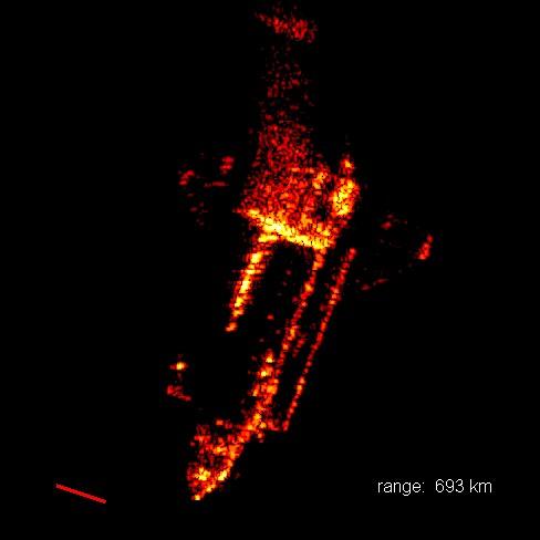
3 SAR image

4 SAR technique
 STAP/GMTI moving target detection with SAR SAR combined with Direction of Arrival = STAP (N antennas, 2D processing!")
5 SAR angle & Doppler SAR Earth surface mapping Doppler frequency changes with angle Low-pass filtering = unfocused SAR (one filter for all distances) Matched filtering = focused SAR (filter changes with distance!) STAP/GMTI moving target detection with SAR SAR combined with Direction of Arrival = STAP (N antennas, 2D processing!) -> GMTI
 object: ship on waves, rotating satellite,")
6 ISAR Inverse SAR imaging a moving (e.g. rotating) object: ship on waves, rotating satellite, aircraft in turn TIRA: 34m antenna for sattelite imaging

7

8 Should be like this...
9

10 IfSAR (InSAR) ex:srtm mission add third dimension to SAR Two antennas -> phase difference SRTM: 60m boom

11 Kilauea
 SAR (along-track resolution) ground bounce and multi-bounce")
12 Ground Penetrating Radar Check before you dig... De-mining Technology: As LF as possible (penetration)... as WB as possible (depth resolution) SAR (along-track resolution) ground bounce and multi-bounce problems

13 GPR image
14 Noise radar Noise can fill wide band = good resolution Pin-type autocorrelation function = low ambiguity Long integration time possible Good compatibility Nonspecific signal = low probability of intercept (LPI) = covert operation Problems: near-far echo moving target (Doppler, stretch) computational complexity

15 Daventry experiment (passive radar) The BBC had a powerful short-wave transmitter Station near Daventry, the Empire Radio Station, with a power output of 10 kw. The wavelength was 49m and the continuous beam was about 30 degrees wide and with a 10 degree elevation. Hadley Page Heyford bomber made a number of passes at differing altitudes from 6000 ft down to 1000 ft. 26th February, 1935 Arnold Wilkins (as operator), A.P.Rowe and Robert Watson Watt. Two receiving aerials fed into a sensitive mobile receiver connected to an oscilloscope. The equipment had been rigged inside a van to detect any echoes that were bounced back from the aeroplane. After careful adjustment, the results were dramatic; 'blips' appeared on the screen at distances of up to eight miles.
16 Passive radar (coherent) Uses audio/tv/cellular transmitters of opportunity Correlation receiver (two antennas) Problem with direct signal & near/far Direction finding more receivers (or more transmitters)
17 Radiometric techniques (totally passive) Natural thermal emission of the scene (passive) Noise-like illuminator (active) millimeter wavelengths (good resolution) concealed weapon detection (CWD) - even non-metallic objects (ceramic weapons and potentially plastic explosives) can be detected detection of immigrants in soft-sided vehicles
 or multilateration (TDoA Time Difference of Arrival) --> multisite operation!")
18 DOA (ESM) systems Direction Of Arrival measuring objects own transmission locate emitters by triangulation (angles) or multilateration (TDoA Time Difference of Arrival) --> multisite operation! Kolchuga (UA), Vera (CZ)
19 IFF (SSR) Identification Friend or Foe (mil.) or Secondary Surveillance Radar (civ.) To shoot or not to shoot? Who is it? Radar equation (1/R4) vs. (1/R2) Altitude measurement problem Technology: transponder, 2- channels 1030 MHz interrogation 1090 MHz reply Required for all the aircrafts flying above some limit.


20


21 IFF with prim. radar
22 IFF Modes Mode 1: 64 codes, (mil ATC): type of aircraft or mission Mode 2, (mil ATC) 4096 "tail numbers" Mode 3/A (civ. ATC - squawk code): instrument flight rules unique A/C codes. G/A A/C under visual flight rules - common code Mode C:aircraft altitude (usually alt.with 3/A) special codes for emergency/hijack etc. Mode S ( selective ) Duplex data link More flight params sent down ADS-B (Automatic Dependent Surveillance Broadcast) reply w/o question
23 AIS Automatic Identification System VHF ( MHz) GPS/GLONASS position, course, maneuvering every 2 to 10 s (underway), 3 min (anchor) various status info (cargo, destination) - every 6 min more accuracy, more info than radar incl. safety-related messages


24 ILS safe landing under bad visibility modulation depth MHz
RADAR CHAPTER 3 RADAR
 RADAR CHAPTER 3 RADAR RDF becomes Radar 1. As World War II approached, scientists and the military were keen to find a method of detecting aircraft outside the normal range of eyes and ears. They found
Fundamental Concepts of Radar
 Fundamental Concepts of Radar Dr Clive Alabaster & Dr Evan Hughes White Horse Radar Limited Contents Basic concepts of radar Detection Performance Target parameters measurable by a radar Primary/secondary
10 Secondary Surveillance Radar
 10 Secondary Surveillance Radar As we have just noted, the primary radar element of the ATC Surveillance Radar System provides detection of suitable targets with good accuracy in bearing and range measurement
Modular Test Approaches for SSR Signal Analysis in IFF Applications
 Modular Test Approaches for SSR Signal Analysis in IFF Applications Military radar applications call for highly specialized test equipment Radar signal analysis applications require highly specialized
ADS-B and WFP Operators. Safety Advantages Security Concerns. Thomas Anthony Director U.S.C. Aviation Safety and Security Program ADS-B
 ADS-B and WFP Operators Safety Advantages Security Concerns Thomas Anthony Director U.S.C. Aviation Safety and Security Program ADS-B How can ADS-B be useful for Humanitarian Air Operation? Are there security
Boost Your Skills with On-Site Courses Tailored to Your Needs
 Boost Your Skills with On-Site Courses Tailored to Your Needs www.aticourses.com The Applied Technology Institute specializes in training programs for technical professionals. Our courses keep you current
39N6E KASTA-2E2 Low-Altitude 3D All-Round Surveillance Radar
 39N6E KASTA-2E2 Low-Altitude 3D All-Round Surveillance Radar The Kasta-2E2 low-altitude 3D all-round surveillance radar is designed to control airspace and to perform automatic detection, range/azimuth/altitude
DHS/U.S. Customs and Border Protection -
 DHS/U.S. Customs and Border Protection - Technology Solutions Program Office (TSPO) DHS/ Unmanned Aircraft System (UAS) October 31, 2006 1 Purpose Provide overall UAS program overview Program Description
A Review of Vulnerabilities of ADS-B
 A Review of Vulnerabilities of ADS-B S. Sudha Rani 1, R. Hemalatha 2 Post Graduate Student, Dept. of ECE, Osmania University, 1 Asst. Professor, Dept. of ECE, Osmania University 2 Email: ssrani.me.ou@gmail.com
O T & E for ESM Systems and the use of simulation for system performance clarification
 O T & E for ESM Systems and the use of simulation for system performance clarification Dr. Sue Robertson EW Defence Limited United Kingdom e-mail: sue@ewdefence.co.uk Tuesday 11 March 2014 EW Defence Limited
Synthetic Aperture Radar
 Synthetic Aperture Radar Picture 1: Radar silhouette of a ship, produced with the ISAR-Processor of the Ocean Master A Synthetic Aperture Radar (SAR), or SAR, is a coherent mostly airborne or spaceborne
Passive Radars on Mobile Platforms - New Changes and New Benefits
 Passive Radars on Mobile Platforms - New Changes and New Benefits Krzysztof Kulpa Warsaw University of Technology, Poland k.kulpa@elka.pw.edu.pl WUT is the largest of 18 Polish technical universities Public
Lecture 1 INTRODUCTION. Dr. Aamer Iqbal Bhatti. Radar Signal Processing 1. Dr. Aamer Iqbal Bhatti
 Lecture 1 INTRODUCTION 1 Radar Introduction. A brief history. Simplified Radar Block Diagram. Two basic Radar Types. Radar Wave Modulation. 2 RADAR The term radar is an acronym for the phrase RAdio Detection
ADS-B Introduction Greg Dunstone
 ADS-B Introduction Greg Dunstone Surveillance Program Lead, Airservices Australia SURVEILLANCE Basics Primary and Secondary radar Why do we need Surveillance? Why surveillance? Improved safety Reduced
Special Projects Office. Mr. Lee R. Moyer Special Projects Office. DARPATech September 2000
 Mr. Lee R. Moyer DARPATech 2000 6-8 September 2000 1 CC&D Tactics Pose A Challenge to U.S. Targeting Systems The Challenge: Camouflage, Concealment and Deception techniques include: Masking: Foliage cover,
Acknowledgment. Process of Atmospheric Radiation. Atmospheric Transmittance. Microwaves used by Radar GMAT Principles of Remote Sensing
 GMAT 9600 Principles of Remote Sensing Week 4 Radar Background & Surface Interactions Acknowledgment Mike Chang Natural Resources Canada Process of Atmospheric Radiation Dr. Linlin Ge and Prof Bruce Forster
EVOLUTION OF AERONAUTICAL SURVEILLANCE
 EVOLUTION OF AERONAUTICAL SURVEILLANCE By: M. Paydar ICAO December 2010 Aeronautical Surveillance Airborne Surveillance Identification Position (at what time?) Additional info (e.g. velocity) Ground Surveillance
Introduction to: Radio Navigational Aids
 Introduction to: Radio Navigational Aids 1 Lecture Topics Basic Principles Radio Directional Finding (RDF) Radio Beacons Distance Measuring Equipment (DME) Instrument Landing System (ILS) Microwave Landing
Mode S Skills 101. OK, so you ve got four basic surveillance skills, you ve got the: ATCRBS Skills Mode S Skills TCAS Skills ADS-B skills
 Mode S Skills 101 OK, so you ve got four basic surveillance skills, you ve got the: ATCRBS Skills Mode S Skills TCAS Skills ADS-B skills Fisher Fisher Slide 1 853D ELECTRONIC SYSTEMS GROUP MODE S 101 Prepared
Use of Satellite-based Technologies to Enhance safety and efficiency in ATC and Airport Operation
 Use of Satellite-based Technologies to Enhance safety and efficiency in ATC and Airport Operation Presented by Felix Tsao Senior Electronics Engineer Civil Aviation Department 26 May 2017 1 Briefing on
SURVEILLANCE MONITORING OF PARALLEL PRECISION APPROACHES IN A FREE FLIGHT ENVIRONMENT. Carl Evers Dan Hicok Rannoch Corporation
 SURVEILLANCE MONITORING OF PARALLEL PRECISION APPROACHES IN A FREE FLIGHT ENVIRONMENT Carl Evers (cevers@rannoch.com), Dan Hicok Rannoch Corporation Gene Wong Federal Aviation Administration (FAA) ABSTRACT
FLY EYE RADAR MINE DETECTION GROUND PENETRATING RADAR ON TETHERED DRONE PASSIVE RADAR FOR SMALL UAS PASSIVE SMALL PROJECTILE TRACKING RADAR
 PASSIVE RADAR FOR SMALL UAS PLANAR MONOLITHICS INDUSTRIES, INC. East Coast: 7311F GROVE ROAD, FREDERICK, MD 21704 USA PHONE: 301-662-5019 FAX: 301-662-2029 West Coast: 4921 ROBERT J. MATHEWS PARKWAY, SUITE
Microwave Imaging of Airborne Targets
 IMA, October 2005 Microwave Imaging of Airborne Targets Brett Borden Physics Department, Naval Postgraduate School, Monterey, CA 93943 USA Telephone: 831 656 2855; Fax: 831 656 2834; email: bhborden@nps.edu
Chain Home & The Daventry Experiment the 75th Anniversary
 26 th February 1935 Chain Home & The Daventry Experiment the 75th Anniversary Andy Tyler, 26 th February 2010 1 Introduction The Daventry Experiment 26 th February 1935 2 UK s Air Defense Strategy 1930
DEVELOPMENT OF MOBILE PASSIVE SECONDARY SURVEILLANCE RADAR
 28 TH INTERNATIONAL CONGRESS OF THE AERONAUTICAL SCIENCES DEVELOPMENT OF MOBILE PASSIVE SECONDARY SURVEILLANCE RADAR Kakuichi Shiomi*, Atsushi Senoguchi* and Shuji Aoyama** *Electronic Navigation Research
UNIT Derive the fundamental equation for free space propagation?
 UNIT 8 1. Derive the fundamental equation for free space propagation? Fundamental Equation for Free Space Propagation Consider the transmitter power (P t ) radiated uniformly in all the directions (isotropic),
Synthetic Aperture Radar. Hugh Griffiths THALES/Royal Academy of Engineering Chair of RF Sensors University College London
 Synthetic Aperture Radar Hugh Griffiths THALES/Royal Academy of Engineering Chair of RF Sensors University College London CEOI Training Workshop Designing and Delivering and Instrument Concept 15 March
AIREON SPACE-BASED ADS-B
 AIREON SPACE-BASED ADS-B 2018 Transport Canada Delegates Conference Steve Bellingham Manager, Navigation Systems Engineering Steve.Bellingham@navcanada.ca CNS/ATM Systems Communication Navigation Surveillance
Coherent detection of weak Mode-S signals from Low Earth Orbit
 ADS-B over Satellite Coherent detection of weak Mode-S signals from Low Earth Orbit 4S Symposium, June 1 st 2016 in Valletta, Malta Toni Delovski, German Aerospace Center (DLR) Institute of Space Systems
Radar Reprinted from "Waves in Motion", McGourty and Rideout, RET 2005
 Radar Reprinted from "Waves in Motion", McGourty and Rideout, RET 2005 What is Radar? RADAR (Radio Detection And Ranging) is a way to detect and study far off targets by transmitting a radio pulse in the
Comparison of Collision Avoidance Systems and Applicability to Rail Transport
 Comparison of Collision Avoidance Systems and Applicability to Rail Transport Cristina Rico García, Andreas Lehner, Thomas Strang and Matthias Röckl Institute of Communication and Navigation Page 1 Cristina
INTRODUCTION TO RADAR SIGNAL PROCESSING
 INTRODUCTION TO RADAR SIGNAL PROCESSING Christos Ilioudis University of Strathclyde c.ilioudis@strath.ac.uk Overview History of Radar Basic Principles Principles of Measurements Coherent and Doppler Processing
Passive Radars as Sources of Information for Air Defence Systems
 Passive Radars as Sources of Information for Air Defence Systems Wiesław Klembowski *, Adam Kawalec **, Waldemar Wizner *Saab Technologies Poland, Ostrobramska 101, 04 041 Warszawa, POLAND wieslaw.klembowski@saabgroup.com
AE4-393: Avionics Exam Solutions
 AE4-393: Avionics Exam Solutions 2008-01-30 1. AVIONICS GENERAL a) WAAS: Wide Area Augmentation System: an air navigation aid developed by the Federal Aviation Administration to augment the Global Positioning
Juan GAVIRIA, Sector Leader AFTTR
 Earth Observation in support of the Western Indian Ocean Marine Highway Development and Coastal and Marine Contamination Prevention Project - Oil spill detection & Coral reef monitoring Juan GAVIRIA, Sector
Western Indian Ocean Marine Highway Development and Coastal and Marine Contamination Prevention Project - Oil spill detection & Coral reef monitoring
 Earth Observation in support of the Western Indian Ocean Marine Highway Development and Coastal and Marine Contamination Prevention Project - Oil spill detection & Coral reef monitoring Juan GAVIRIA, Sector
Electronic Warfare (EW) Principles and Overview p. 1 Electronic Warfare Taxonomy p. 6 Electronic Warfare Definitions and Areas p.
 Principles and Overview p. 1 Electronic Warfare Taxonomy p. 6 Electronic Warfare Definitions and Areas p.") Electronic Warfare (EW) Principles and Overview p. 1 Electronic Warfare Taxonomy p. 6 Electronic Warfare Definitions and Areas p. 6 Electronic Warfare Support Measures (ESM) p. 6 Signals Intelligence (SIGINT)
Electronic Warfare (EW) Principles and Overview p. 1 Electronic Warfare Taxonomy p. 6 Electronic Warfare Definitions and Areas p. 6 Electronic Warfare Support Measures (ESM) p. 6 Signals Intelligence (SIGINT)
Adaptive SAR Results with the LiMIT Testbed
 Adaptive SAR Results with the LiMIT Testbed Gerald Benitz Adaptive Sensor Array Processing Workshop 7 June 2005 999999-1 Outline LiMIT collection platform SAR sidelobe recovery Electronic Protection (EP)
Mission Solution 300
 Mission Solution 300 Standard configuration for point defence Member of the Thales Mission Solution family Standard configuration of integrated sensors, effectors, CMS, communication system and navigation
Radar. Seminar report. Submitted in partial fulfillment of the requirement for the award of degree Of Mechanical
 A Seminar report on Radar Submitted in partial fulfillment of the requirement for the award of degree Of Mechanical SUBMITTED TO: SUBMITTED BY: www.studymafia.org www.studymafia.org Preface I have made
Evaluation Results of Airport Surface Multilateration. Hiromi Miyazaki Electronic Navigation Research Institute
 Evaluation Results of Airport Surface Multilateration Hiromi Miyazaki Electronic Navigation Research Institute 1 Contents Introduction Background, Purposes Overview of Multilateration (MLAT) Advantages,
[EN 105] Evaluation Results of Airport Surface Multilateration
![[EN 105] Evaluation Results of Airport Surface Multilateration](/thumbs/96/127806354.jpg "[EN 105] Evaluation Results of Airport Surface Multilateration") ENRI Int. Workshop on ATM/CNS. Tokyo, Japan. (EIWAC 2010) [EN 105] Evaluation Results of Airport Surface Multilateration (EIWAC 2010) + H. Miyazaki*, T. Koga**, E. Ueda*, Y. Kakubari*, S. Nihei* *Communication,
ENRI Int. Workshop on ATM/CNS. Tokyo, Japan. (EIWAC 2010) [EN 105] Evaluation Results of Airport Surface Multilateration (EIWAC 2010) + H. Miyazaki*, T. Koga**, E. Ueda*, Y. Kakubari*, S. Nihei* *Communication,
Sources of Geographic Information
 Sources of Geographic Information Data properties: Spatial data, i.e. data that are associated with geographic locations Data format: digital (analog data for traditional paper maps) Data Inputs: sampled
Chapter 3 Solution to Problems
 Chapter 3 Solution to Problems 1. The telemetry system of a geostationary communications satellite samples 100 sensors on the spacecraft in sequence. Each sample is transmitted to earth as an eight-bit
Know how Pulsed Doppler radar works and how it s able to determine target velocity. Know how the Moving Target Indicator (MTI) determines target
 determines target") Moving Target Indicator 1 Objectives Know how Pulsed Doppler radar works and how it s able to determine target velocity. Know how the Moving Target Indicator (MTI) determines target velocity. Be able to
Moving Target Indicator 1 Objectives Know how Pulsed Doppler radar works and how it s able to determine target velocity. Know how the Moving Target Indicator (MTI) determines target velocity. Be able to
AIR ROUTE SURVEILLANCE 3D RADAR
 AIR TRAFFIC MANAGEMENT AIR ROUTE SURVEILLANCE 3D RADAR Supplying ATM systems around the world for more than 30 years indracompany.com ARSR-10D3 AIR ROUTE SURVEILLANCE 3D RADAR ARSR 3D & MSSR Antenna Medium
NAVIGATION (2) RADIO NAVIGATION
 RADIO NAVIGATION") 1 An aircraft is "homing" to a radio beacon whilst maintaining a relative bearing of zero. If the magnetic heading decreases, the aircraft is experiencing: A left drift B right drift C a wind from the
1 An aircraft is "homing" to a radio beacon whilst maintaining a relative bearing of zero. If the magnetic heading decreases, the aircraft is experiencing: A left drift B right drift C a wind from the
Operational Considerations for Passive Bistatic Radar
 Operational Considerations for Passive Bistatic Radar Presented at 1st RADAR Conference & Exhibition for the Kingdom of Saudi Arabia 8 December 2014 Dr Clayton Stewart Visiting Professor, Electronic and
Introduction Objective and Scope p. 1 Generic Requirements p. 2 Basic Requirements p. 3 Surveillance System p. 3 Content of the Book p.
 Preface p. xi Acknowledgments p. xvii Introduction Objective and Scope p. 1 Generic Requirements p. 2 Basic Requirements p. 3 Surveillance System p. 3 Content of the Book p. 4 References p. 6 Maritime
Set No.1. Code No: R
 Set No.1 IV B.Tech. I Semester Regular Examinations, November -2008 RADAR SYSTEMS ( Common to Electronics & Communication Engineering and Electronics & Telematics) Time: 3 hours Max Marks: 80 Answer any
COMPARISON OF SURVEILLANCE TECHNOLOGIES ICAO
 COMPARISON OF SURVEILLANCE TECHNOLOGIES By: M. Paydar ICAO ICAO Seminar on the Implementation of Aeronautical Surveillance and Automation Systems in the SAM Region (San Carlos de Bariloche, Argentina,
Automated Traffic Control for Smart Landing Facilities
 Automated Traffic Control for Smart Landing Facilities by Charles Henri Florin Thesis submitted to the Faculty of Virginia Polytechnic Institute and State University in partial fulfillment of the requirements
Automatic Dependent Surveillance -ADS-B
 ASECNA Workshop on ADS-B (Dakar, Senegal, 22 to 23 July 2014) Automatic Dependent Surveillance -ADS-B Presented by FX SALAMBANGA Regional Officer, CNS WACAF OUTLINE I Definition II Principles III Architecture
Interferometric Cartwheel 1
 The Interferometric CartWheel A wheel of passive radar microsatellites for upgrading existing SAR projects D. Massonnet, P. Ultré-Guérard (DPI/EOT) E. Thouvenot (DTS/AE/INS/IR) Interferometric Cartwheel
Enhancing space situational awareness using passive radar from space based emitters of opportunity
 Tracking Space Debris Craig Benson School of Engineering and IT Enhancing space situational awareness using passive radar from space based emitters of opportunity Space Debris as a Problem Debris is fast
Microwave Remote Sensing
 Provide copy on a CD of the UCAR multi-media tutorial to all in class. Assign Ch-7 and Ch-9 (for two weeks) as reading material for this class. HW#4 (Due in two weeks) Problems 1,2,3 and 4 (Chapter 7)
Pilot s Operating Handbook Supplement AS-21
 SECTION 9 Pilot s Operating Handbook Supplement Mode S Transponder GARMIN GTX 335 / GTX 345 This supplement is applicable and must be inserted into Section 9 of the POH when a GARMIN GTX 335 or GTX 345
Introduction to Imaging Radar INF-GEO 4310
 Introduction to Imaging Radar INF-GEO 4310 22.9.2011 Literature Contact: yoann.paichard@ffi.no Suggested readings: Fundamentals of Radar Signal Processing, M.A. Richards, McGraw-Hill, 2005 High Resolution
Multi Sensor Data Fusion
 Multi Sensor Data Fusion for improved maritime traffic monitoring in the Canadian Arctic Giulia Battistello*, Martin Ulmke*, Javier Gonzalez*, Camilla Mohrdieck** (*) Fraunhofer FKIE Sensor Data and Information
Monitoring Pulse Based Navigation Signals in Flight
 Monitoring Pulse Based Navigation Signals in Flight Rolf Seide Senior Manager Competence Center Flight Inspection Systems Aerodata AG Herrmann-Blenk-Strasse 36 D-38108 Braunschweig Fax: +49 531 2359 222
Dimov Stojče Ilčev. CNS Systems
 Stratospheric Platform Systems (SPS) Presentation by: Dimov Stojče Ilčev Durban University of Technology (DUT) Space Science Centre (SSC) CNS Systems August 2011 SPS for Mobile CNS Applications Stratospheric
DEVELOPMENT OF PASSIVE SURVEILLANCE RADAR
 DEVELOPMENT OF PASSIVE SURVEILLANCE RADAR Kakuichi Shiomi* and Shuji Aoyama** *Electronic Navigation Research Institute, Japan **IRT Corporation, Japan Keywords: Radar, Passive Radar, Passive Surveillance
ATS 351 Lecture 9 Radar
 ATS 351 Lecture 9 Radar Radio Waves Electromagnetic Waves Consist of an electric field and a magnetic field Polarization: describes the orientation of the electric field. 1 Remote Sensing Passive vs Active
ICAO SARPS AND GUIDANCE DOCUMENTS ON SURVEILLANCE SYSTEMS
 ICAO SARPS AND GUIDANCE DOCUMENTS ON SURVEILLANCE SYSTEMS MEETING/WORKSHOP ON AUTOMATIC DEPENDENT SURVEILLANCE BROADCAST (ADS B) IMPLEMENTATION (ADS B/IMP) (Lima, Peru, 13 to 16 November 2017) ONOFRIO
A bluffer s guide to Radar
 A bluffer s guide to Radar Andy French December 2009 We may produce at will, from a sending station, an electrical effect in any particular region of the globe; (with which) we may determine the relative
Satellite Communications. Chapter 9
 Satellite Communications Chapter 9 Satellite-Related Terms Earth Stations antenna systems on or near earth Uplink transmission from an earth station to a satellite Downlink transmission from a satellite
Satellite Communications. Chapter 9
 Satellite Communications Chapter 9 Satellite-Related Terms Earth Stations antenna systems on or near earth Uplink transmission from an earth station to a satellite Downlink transmission from a satellite
Final Examination. 22 April 2013, 9:30 12:00. Examiner: Prof. Sean V. Hum. All non-programmable electronic calculators are allowed.
 UNIVERSITY OF TORONTO FACULTY OF APPLIED SCIENCE AND ENGINEERING The Edward S. Rogers Sr. Department of Electrical and Computer Engineering ECE 422H1S RADIO AND MICROWAVE WIRELESS SYSTEMS Final Examination
Exam questions: AE3-295-II
 Exam questions: AE3-295-II 1. NAVIGATION SYSTEMS (30 points) In this question we consider the DME radio beacon. [a] What does the acronym DME stand for? (3 points) DME stand for Distance Measuring Equipment
EE Chapter 14 Communication and Navigation Systems
 EE 2145230 Chapter 14 Communication and Navigation Systems Two way radio communication with air traffic controllers and tower operators is necessary. Aviation electronics or avionics: Avionic systems cover
RADAR REMOTE SENSING
 RADAR REMOTE SENSING Jan G.P.W. Clevers & Steven M. de Jong Chapter 8 of L&K 1 Wave theory for the EMS: Section 1.2 of L&K E = electrical field M = magnetic field c = speed of light : propagation direction
Ron Turner Technical Lead for Surface Systems. Syracuse, NY. Sensis Air Traffic Systems - 1
 Multilateration Technology Overview Ron Turner Technical Lead for Surface Systems Sensis Corporation Syracuse, NY Sensis Air Traffic Systems - 1 Presentation Agenda Multilateration Overview Transponder
Most important aerospace outcomes of the WRC-15
 Most important aerospace outcomes of the WRC-15 Attila MATAS matas@itu.int @AttilaMatas ICAO / UNOOSA Symposium 15 17 March 2016, Abu Dhabi, United Arab Emirates Head, Space Publication and Registration
Radar Systems Engineering Lecture 14 Airborne Pulse Doppler Radar
 Radar Systems Engineering Lecture 14 Airborne Pulse Doppler Radar Dr. Robert M. O Donnell Guest Lecturer Radar Systems Course 1 Examples of Airborne Radars F-16 APG-66, 68 Courtesy of US Navy Courtesy
Airmanship Knowledge Learning Outcome 1 Air Traffic Control
 Uncontrolled copy not subject to amendment Airmanship Knowledge Learning Outcome 1 Air Traffic Control Revision 1.00 Airmanship Knowledge Learning Outcome 1 Understand the types of airfield operations
SURVEILLANCE SYSTEMS. Operational Improvement and Cost Savings, from Airport Surface to Airspace
 SURVEILLANCE SYSTEMS Operational Improvement and Cost Savings, from Airport Surface to Airspace Sergio Martins Director, Air Traffic Management - Latin America 2 AGENDA Airport Surface Solutions A-SMGCS
RECOMMENDATION ITU-R M.1639 *
 Rec. ITU-R M.1639 1 RECOMMENDATION ITU-R M.1639 * Protection criterion for the aeronautical radionavigation service with respect to aggregate emissions from space stations in the radionavigation-satellite
Silent Sentry. Lockheed Martin Mission Systems. Jonathan Baniak Dr. Gregory Baker Ann Marie Cunningham Lorraine Martin.
 Silent Sentry Passive Surveillance Lockheed Martin Mission Systems Jonathan Baniak Dr. Gregory Baker Ann Marie Cunningham Lorraine Martin June 7, 1999 6/7/99 1 Contact: Lorraine Martin Telephone: (301)
Sense and Avoid: Analysis of Sensor Design Factors for Optimal Deconfliction
 Sense and Avoid: Analysis of Sensor Design Factors for Optimal Deconfliction Basically, we want this: For these: Background: UAVs Weight Mid-Sized UAVs The Big Ones Small UAVs MAVs The area of study for
Xihua University; Chengdu, Sichuan, China: 11 Jan. 2016
 Defence Science & Technology Agency; Singapore; 5 Jan. 2016 State Radio monitoring center Testing Center (SRTC) Beijing; 8 Jan.2016 Xihua University; Chengdu, Sichuan, China: 11 Jan. 2016 ATDT Warsaw 4
Applying Multisensor Information Fusion Technology to Develop an UAV Aircraft with Collision Avoidance Model
 1 Applying Multisensor Information Fusion Technology to Develop an UAV Aircraft with Collision Avoidance Model {Final Version with
AERONAUTICAL SURVEILLANCE PANEL (ASP) Working Group Meeting. Montreal, 15 to 19 October Draft Manual on Multilateration Surveillance
 Working Group Meeting. Montreal, 15 to 19 October Draft Manual on Multilateration Surveillance") WP ASP03-11 Agenda Item 5.5 16 October 2007 AERONAUTICAL SURVEILLANCE PANEL (ASP) Working Group Meeting Montreal, 15 to 19 October 2007 Draft Manual on Multilateration Surveillance (Prepared by TSG) (Presented
WP ASP03-11 Agenda Item 5.5 16 October 2007 AERONAUTICAL SURVEILLANCE PANEL (ASP) Working Group Meeting Montreal, 15 to 19 October 2007 Draft Manual on Multilateration Surveillance (Prepared by TSG) (Presented
Data and Computer Communications Chapter 4 Transmission Media
 Data and Computer Communications Chapter 4 Transmission Media Ninth Edition by William Stallings Data and Computer Communications, Ninth Edition by William Stallings, (c) Pearson Education - Prentice Hall,
BEYOND RADAR ERA MILITARY SOLUTIONS. Surveillance Reconnaissance Military ATM Command&Control Systems
 BEYOND RADAR ERA MILITARY SOLUTIONS Surveillance Reconnaissance Military ATM Command&Control Systems SEES WITHOUT BEING SEEN SENSORS SURVEILLANCE & RECONNAISSANCE VERA-NG Passive ESM Tracker VERA-NG addresses
SuperDARN (Super Dual Auroral Radar Network)
") SuperDARN (Super Dual Auroral Radar Network) What is it? How does it work? Judy Stephenson Sanae HF radar data manager, UKZN Ionospheric radars Incoherent Scatter radars AMISR Arecibo Observatory Sondrestrom
SuperDARN (Super Dual Auroral Radar Network) What is it? How does it work? Judy Stephenson Sanae HF radar data manager, UKZN Ionospheric radars Incoherent Scatter radars AMISR Arecibo Observatory Sondrestrom
Communication and Navigation Systems for Aviation
 Higher National Unit Specification General information for centres Unit title: Communication and Navigation Systems for Aviation Unit code: F0M3 35 Unit purpose: This Unit is designed to allow candidates
Microwaves. Group 7, 11/22/2013
 Microwaves Group 7, 11/22/2013 Matthew Spickard History/Definition Andrew Miller Range of practical application Dustin Morris Detailed application and equation definition History First predicted by James
Introduction Active microwave Radar
 RADAR Imaging Introduction 2 Introduction Active microwave Radar Passive remote sensing systems record electromagnetic energy that was reflected or emitted from the surface of the Earth. There are also
Imaging Using Microwaves
 Imaging Using Microwaves Delivering Exceptional Service in the National Interest Data created by Interferometric Synthetic Aperture Radar Unclassified Unlimited Release Name/Org: _Judith A. Ruffner, _
AN/APN-242 Color Weather & Navigation Radar
 AN/APN-242 Color Weather & Navigation Radar Form, Fit and Function Replacement for the APN-59 Radar Previous Configuration: APN-59 Antenna Stabilization Data Generator Antenna Subsystem Radar Receiver
By Gokula Krishnan S. Generated by Foxit PDF Creator Foxit Software For evaluation only.
 By Gokula Krishnan S Generated by Foxit PDF Creator Foxit Software RAdio Detection And Ranging By US Navy in 1940 RDF (Range and Direction Finding ) in the United Kingdom In the 1960s Solid State delays
Radar observables: Target range Target angles (azimuth & elevation) Target size (radar cross section) Target speed (Doppler) Target features (imaging)
 Target size (radar cross section) Target speed (Doppler) Target features (imaging)") Fundamentals of Radar Prof. N.V.S.N. Sarma Outline 1. Definition and Principles of radar 2. Radar Frequencies 3. Radar Types and Applications 4. Radar Operation 5. Radar modes What What is is Radar? Radar?
Fundamentals of Radar Prof. N.V.S.N. Sarma Outline 1. Definition and Principles of radar 2. Radar Frequencies 3. Radar Types and Applications 4. Radar Operation 5. Radar modes What What is is Radar? Radar?
Earth Observation from a Moon based SAR: Potentials and Limitations
 Earth Observation from a Moon based SAR: Potentials and Limitations F. Bovenga 1, M. Calamia 2,3, G. Fornaro 5, G. Franceschetti 4, L. Guerriero 1, F. Lombardini 5, A. Mori 2 1 Politecnico di Bari - Dipartimento
Keywords. DECCA, OMEGA, VOR, INS, Integrated systems
 Keywords. DECCA, OMEGA, VOR, INS, Integrated systems 7.4 DECCA Decca is also a position-fixing hyperbolic navigation system which uses continuous waves and phase measurements to determine hyperbolic lines-of
AIRPLANE FLIGHT MANUAL AQUILA AT01. Date of Issue A.01 Initial Issue (minor change MB-AT ) all March
 all March") 0.1 LIST OF REVISIONS AND AMENDMENTS Revision Reason for Amendment/Revision Affected Pages Date of Issue A.01 Initial Issue (minor change MB-AT01-00297) all 2009 19. March 0.2 LIST OF EFFECTIVE PAGES Page
0.1 LIST OF REVISIONS AND AMENDMENTS Revision Reason for Amendment/Revision Affected Pages Date of Issue A.01 Initial Issue (minor change MB-AT01-00297) all 2009 19. March 0.2 LIST OF EFFECTIVE PAGES Page
Radar Imaging Wavelengths
 A Basic Introduction to Radar Remote Sensing ~~~~~~~~~~ Rev. Ronald J. Wasowski, C.S.C. Associate Professor of Environmental Science University of Portland Portland, Oregon 3 November 2015 Radar Imaging
RADAR and its Applications
 IJCTA, 10(03), 2017, pp. 1-9 International Science Press Closed Loop Control of Soft Switched Forward Converter Using Intelligent Controller 1 RADAR and its Applications Niraj Prasad Bhatta* and M. GeethaPriya**
746A27 Remote Sensing and GIS
 746A27 Remote Sensing and GIS Lecture 1 Concepts of remote sensing and Basic principle of Photogrammetry Chandan Roy Guest Lecturer Department of Computer and Information Science Linköping University What
ADS-B Performance. APANPIRG ADS-B TASK FORCE SEMINAR Nadi, Fiji. Greg Dunstone Technology Development. Airservices Australia. Airservices Australia
 ADS-B Performance APANPIRG ADS-B TASK FORCE SEMINAR Nadi, Fiji Greg Dunstone Technology Development Airservices Australia Template Last Updated: 24 February 2005 Introduction & Overview Ground stations
1 PERFORMANCE COMPARISION BETWEEN HIGHER-ORDER AND RWG BASIS FUNCTIONS
 1 PERFORMANCE COMPARISION BETWEEN HIGHER-ORDER AND RWG BASIS FUNCTIONS Two monopoles are mounted on a PEC cylinder oriented along the z axis. The length and radius of the cylinder are 5. m and 1. m, respectively.