Polaris Sensor Technologies, Inc. Visible - Limited Detection Thermal - No Detection Polarization - Robust Detection etherm - Ultimate Detection
|
|
|
- Virginia Jenkins
- 5 years ago
- Views:
Transcription


1 Polaris Sensor Technologies, Inc. DETECTION OF OIL AND DIESEL ON WATER Visible - Limited Detection - No Detection - Robust Detection etherm - Ultimate Detection

 Gimbal mount for automated scanning Easy")


2 Pyxis Features: Day or night real-time sensing Platform agnostic (fixed site, mast, buoy, drone, handheld etc.) Gimbal mount for automated scanning Easy installation and integration Simple user interface for real-time local or remote operation and monitoring Pyxis Vision Science software for highlighting regions of interest MOUNTING OPTIONS drone handheld oil rig


3 The Power of 400% BETTER DETECTION THAN THERMAL crude oil 1 crude oil 2 diesel Visible etherm Pyxis measures both the thermal and polarization content of an oil spill scene. etherm combines the two for superior detection across all conditions tested, including the detection of recoverable oil in both flat water and breaking waves. DETECTION OF OIL ON WATER - DAY OR NIGHT day Thick Oil Thin Oil night Visible A time lapse, overnight test shows the detection performance of polarization imagery from 3 to more than 50 times better contrast over thermal imaging. The polarimetric contrast is consistent throughout the night whereas the thermal contrast essentially went away several times throughout the night.


 and the background (water), polarization")

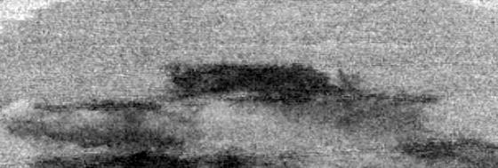
4 Real-Time Imaging for... Detection and tracking of oil and diesel on water and shorelines Differentiating between thick and thin oil Remote monitoring of rigs and wells Reducing manpower and costs associated with monitoring Search and rescue for watercraft and downed aircraft OIL SHEEN IN COMPLEX ENVIRONMENTS surface wellings kelp forest oil sheen sun glint Visible etherm Following the Santa Barbara oil spill in 2015, oil is evident and detectable in an aerial survey using Pyxis, even after clean-up efforts. While thermal imagery requires some small thermal difference between the object (oil) and the background (water), polarization imagery has no such limitation. The Pyxis captures thermal and polarized imagery and fuses both data types into our proprietary etherm data product. Our software experts have developed Pyxis Vision Science to filter through the data and identify the things that matter most, highlighting them with etherm. Oil on water can be distinguished from land, sea kelp, and sun glint, or colorized for greater clarity.

5 Pyxis Vision Science Software Real-time display of polarization enhanced thermal and standard thermal video Data recording Region of interest calculations and plots Histogram, auto-scale, and color palette adjustments Image processing algorithm selection for autonomous detection File playback and data analysis Video and snapshot exporting System Requirements: Windows 7 or higher and 4GB memory


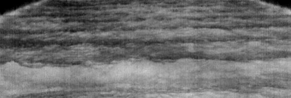
6 Local and Remote Operation EMULSIFIED OIL WITH WAVES Visible etherm It s common for oil to become emulsified over the course of a spill. Being able to identify emulsified oil is a crucial part of spill response efforts. Pyxis provides this much needed capability.


7 Beach Assessment Oil on Sand and Rocks Pyxis LWIR Visible Camera DETECTION OF OIL ON SAND AND ROCKS oiled rock oil on water oiled sand clean water Visible etherm Recent testing shows Pyxis as an asset for detecting oil on sand and rocks. A small beach scene was created and a small amount of oil was placed on one rock and onto the sand. While not visible with thermal, the oil is clearly visible in the etherm images taken with Pyxis. Once the oil soaks into the sand, it s undetectable in thermal and polarization. However, when water washes over the rocks and sand mimicking waves crashing on the beach, the oil is washed back up to the surface and detected by using the Pyxis with etherm. PATENTS PENDING


8 200 Westside Square, Suite 320 Huntsville, Alabama About Polaris Sensor Technologies, Inc. Polaris Sensor Technologies, Inc. is a dynamic commercial and prime government supplier providing innovative designs, unique products, and state-of-the-art analyses of optical systems. We have a team of optical experts who have extensive experience in designing high-performance optical systems. Our portfolio includes polarization-based imaging systems, sensors, seekers, light scattering modeling, and measurement services. Located in Huntsville, Alabama, our engineering facility features an extensive laboratory. Holding many national and international patents, Polaris creates custom hardware and unique software solutions providing our customers with the ability to meet mission objectives Polaris Sensor Technologies, Inc.


9 About the Pyxis Family Pyxis is the industry s first system to combine the power of polarization with standard thermal imaging, making it the lowest SWaP-C polarization sensing thermal camera. Long-Wave InfraRed (LWIR) thermal imagers have proven their use in a variety of commercial and military applications for the detection, recognition, and identification of objects and persons. But thermal often falls short in situations involving high clutter and low thermal contrast. This is when the polarization enhanced Pyxis prevails. How It Works exploits geometry and material composition to vastly improve contrast and detail, which is especially effective when thermal contrast is low or when an object becomes hidden in background clutter. Combining polarization with thermal imaging fills the gap needed to deliver unseen detail, improve visibility in low contrast situations, and enable fast decision-making in high-stakes scenarios. Our software combines polarization and thermal while adding a color overlay to highlight the things you want to see the most. Pyxis : Real-Time Data Collection and Analysis for Critical Awareness Facial Recognition enhanced thermal imaging analyzes facial features by sensing subtle changes in shape for a higher degree of identification accuracy. Enhanced Autonomous Vehicle Navigation With polarization, it is easy to distinguish the roadway, obstacles, and other vehicles at a distance, even when thermal has low contrast or is misleading due to shadows. Target Detection coupled with specialized software provides the detection of military vehicles and other threats that are hardly seen in thermal imagery while eliminating background clutter. Enhanced Oil on Water provides the needed sensitivity for oil on water detection. plus polarization with a color overlay provides accurate discrimination and detection. The Pyxis is up to 400% more effective at detecting oil and other petrochemicals on water than the competing technology info@polarissensor.com Copyright 2017 Polaris Sensor Technologies, Inc.

 Field of View (Standard Lens) 30 x 25 Camera Frame Rate")


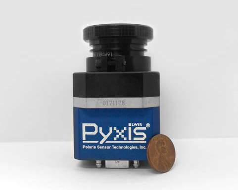
10 Pyxis Models Detector Operating Temperature Waveband Pyxis LWIR 640-A Pyxis LWIR 640-GR Pyxis LWIR 640-G Uncooled VOx Microbolometer 0 C-45 C 7.5µm-13.5µm Pixel Pitch 17µm Resolution (HxV) Standard Lens 640 x 512 pixels 20mm f/0.85 (others available) Field of View (Standard Lens) 30 x 25 Camera Frame Rate 30Hz or 7.5Hz Full Frame Pixel Operability >99.9% f/0.85 f/0.85 Input Voltage Data Interface Environmental NTSC/14-bit Camera Link N/A 5VDC <70mK <0.5% GigE Designed to IP info@polarissensor.com Copyright 2017 Polaris Sensor Technologies, Inc. 5VDC or ethernet (POE) Size with Standard Lens (LxWxH) 2.65 x 1.75 x x 2.25 x x 1.83 x 1.83 Weight with Standard Lens GigE and NTSC Steady State 70 F 4W 2.5W 4W with 5VDC, 6W with POE Peak 70 F 5.3W 3.5W 5W with 5VDC, 7W with POE Highlights PATENTS PENDING 4.9oz - On-board FPGA - On-board user interface - data products over NTSC 12oz - On-board GigE frame grabber - Ruggedized housing 6.5oz N/A - On-board GigE frame grabber - filter unprocessed over NTSC
Polaris Sensor Technologies, Inc. SMALLEST THERMAL POLARIMETER
 Polaris Sensor Technologies, Inc. SMALLEST THERMAL POLARIMETER Pyxis LWIR 640 Industry s smallest polarization enhanced thermal imager Up to 400% greater detail and contrast than standard thermal Real-time
Infrared polarimetric sensing of oil on water
 Infrared polarimetric sensing of oil on water David B. Chenault, Justin P. Vaden Polaris Sensor Technologies, Inc., 200 Westside Square, Suite 320, Huntsville, AL 35801 ABSTRACT Infrared polarimetry is
Infrared polarimetric sensing of oil on water
 Infrared polarimetric sensing of oil on water David B. Chenault* a, Justin P. Vaden a, Douglas A. Mitchell b, Erik D. Demicco b a Polaris Sensor Technologies, Inc., 200 Westside Square, Suite 320, Huntsville,
Pyxis handheld polarimetric imager
 Pyxis handheld polarimetric imager David B. Chenault* a, J. Larry Pezzaniti a, Justin P. Vaden a, a Polaris Sensor Technologies, Inc., 200 Westside Square, Suite 320, Huntsville, AL 35801 ABSTRACT The
Pyxis : Enhanced Thermal Imaging with a Division of Focal Plane Polarimeter
 Distribution A: Approved for public release; distribution is unlimited. Pyxis : Enhanced Thermal Imaging with a Division of Focal Plane Polarimeter 15 September 2015 David Chenault, Larry Pezzaniti, Justin
TAMARISK INFRARED SOLUTIONS THAT FIT
 TAMARISK INFRARED SOLUTIONS THAT FIT For applications constrained by aggressive size, weight and power, DRS Technologies Tamarisk family of 17 µm uncooled thermal imaging modules offer flexible solutions
IR Laser Illuminators
 Eagle Vision PAN/TILT THERMAL & COLOR CAMERAS - All Weather Rugged Housing resist high humidity and salt water. - Image overlay combines thermal and video image - The EV3000 CCD colour night vision camera
SMALL UNMANNED AERIAL VEHICLES AND OPTICAL GAS IMAGING
 SMALL UNMANNED AERIAL VEHICLES AND OPTICAL GAS IMAGING A look into the Application of Optical Gas imaging from a suas 4C Conference- 2017 Infrared Training Center, All rights reserved 1 NEEDS ANALYSIS
PRODUCT OVERVIEW FOR THE. Corona 350 II FLIR SYSTEMS POLYTECH AB
 PRODUCT OVERVIEW FOR THE Corona 350 II FLIR SYSTEMS POLYTECH AB Table of Contents Table of Contents... 1 Introduction... 2 Overview... 2 Purpose... 2 Airborne Data Acquisition and Management Software (ADAMS)...
Reprint (R43) Polarmetric and Hyperspectral Imaging for Detection of Camouflaged Objects. Gooch & Housego. June 2009
 Polarmetric and Hyperspectral Imaging for Detection of Camouflaged Objects. Gooch & Housego. June 2009") Reprint (R43) Polarmetric and Hyperspectral Imaging for Detection of Camouflaged Objects Gooch & Housego June 2009 Gooch & Housego 4632 36 th Street, Orlando, FL 32811 Tel: 1 407 422 3171 Fax: 1 407 648
Reprint (R43) Polarmetric and Hyperspectral Imaging for Detection of Camouflaged Objects Gooch & Housego June 2009 Gooch & Housego 4632 36 th Street, Orlando, FL 32811 Tel: 1 407 422 3171 Fax: 1 407 648
Thermal Imaging Solutions Esprit Ti and TI2500
 Thermal Imaging Solutions Esprit Ti and TI2500 1 For all the power users who have been searching for a revolutionary advance in video system capabilities and performance, Pelco Thermal Imaging Solutions
Application Note. Digital Low-Light CMOS Camera. NOCTURN Camera: Optimized for Long-Range Observation in Low Light Conditions
 Digital Low-Light CMOS Camera Application Note NOCTURN Camera: Optimized for Long-Range Observation in Low Light Conditions PHOTONIS Digital Imaging, LLC. 6170 Research Road Suite 208 Frisco, TX USA 75033
Microbolometers for Infrared Imaging and the 2012 Student Infrared Imaging Competition
 Microbolometers for Infrared Imaging and the 2012 Student Infrared Imaging Competition George D Skidmore, PhD Principal Scientist DRS Technologies RSTA Group Competition Flyer 2 Passive Night Vision Technologies
FLIR K2. FLIR-DIRECT.ca
 Copyright All rights reserved worldwide. Names and marks appearing herein are either registered trademarks or trademarks of FLIR Systems and/or its subsidiaries. All other trademarks, trade names or company
MSRC Tactical Oil Spill Surveillance and Remote Sensing
 MSRC Tactical Oil Spill Surveillance and Remote Sensing Industry Technical Advisory Committee for Oil spill Response October 25, 2016 0 Historical Perspective -- Oil Spill Surveillance in U.S Exxon Valdez
ULISSE COMPACT THERMAL
 2014/01/20 UNIT WITH INTEGRATED THERMAL AND DAY/NIGHT CAMERAS MAIN FEATURES Variable speed: 0.1-200 /s Pan/Tilt Horizontal continuous rotation, vertical -90 /+90 IP66 Dual independent video output Complete
A World Leading Long Range Surveillance Platform Key Features The Silent Sentinel Range Tel: +44 (0)
") A World Leading Long Range Surveillance Platform The Jaegar is a highly modular ready to go Single Mast Surveillance solution, ideal for medium to long range surveillance applications using video and thermal
A World Leading Long Range Surveillance Platform The Jaegar is a highly modular ready to go Single Mast Surveillance solution, ideal for medium to long range surveillance applications using video and thermal
Compact Dual Field-of-View Telescope for Small Satellite Payloads
 Compact Dual Field-of-View Telescope for Small Satellite Payloads James C. Peterson Space Dynamics Laboratory 1695 North Research Park Way, North Logan, UT 84341; 435-797-4624 Jim.Peterson@sdl.usu.edu
Mini Market Study Report August 2011
 Naval Surface Warfare Center (NAVSEA) Crane Division Two Band Imaging System (US Patent No. 6,969,856) Mini Market Study Report August 2011 Sponsored by: Integrated Technology Transfer Network, California
LWIR NUC Using an Uncooled Microbolometer Camera
 LWIR NUC Using an Uncooled Microbolometer Camera Joe LaVeigne a, Greg Franks a, Kevin Sparkman a, Marcus Prewarski a, Brian Nehring a, Steve McHugh a a Santa Barbara Infrared, Inc., 30 S. Calle Cesar Chavez,
CHALLENGES FOR VEHICULAR VISION SYSTEMS WHITE PAPER WP Rev /03/2014 Commercial-in-Confidence
 www.rfel.com CHALLENGES FOR VEHICULAR VISION SYSTEMS 20140225WP Rev. 4.0 03/03/2014 Commercial-in-Confidence RFEL Ltd. All rights reserved. 1 Summary This white paper presents the game changing performance
MR-i. Hyperspectral Imaging FT-Spectroradiometers Radiometric Accuracy for Infrared Signature Measurements
 MR-i Hyperspectral Imaging FT-Spectroradiometers Radiometric Accuracy for Infrared Signature Measurements FT-IR Spectroradiometry Applications Spectroradiometry applications From scientific research to
Ronald Driggers Optical Sciences Division Naval Research Laboratory. Infrared Imaging in the Military: Status and Challenges
 Ronald Driggers Optical Sciences Division Infrared Imaging in the Military: Status and Challenges Outline Military Imaging Bands Lets Orient Ourselves Primary Military Imaging Modes and Challenges Target
NEXTMAP. P-Band. Airborne Radar Imaging Technology. Key Benefits & Features INTERMAP.COM. Answers Now
 INTERMAP.COM Answers Now NEXTMAP P-Band Airborne Radar Imaging Technology Intermap is proud to announce the latest advancement of their Synthetic Aperture Radar (SAR) imaging technology. Leveraging over
Spotlight White paper
 Spotlight White paper Benefits of digital highlighting vs. laser By Logitech, December 2017 EXECUTIVE SUMMARY The new Logitech Spotlight Presentation Remote with digital highlighting solves the laser visibility
Introducing Thermal Technology Alcon 2015
 Introducing Thermal Technology Alcon 2015 Chapter 1 The basics of thermal imaging technology Basics of thermal imaging technology 1. Thermal Radiation 2. Thermal Radiation propagation 3. Thermal Radiation
Continuous Wave Laser Illumination: The Clear Choice over Thermal Imaging for Long-Range, High-Magnification Night Vision Perimeter Protection
 Continuous Wave Laser Illumination: The Clear Choice over Thermal Imaging for Long-Range, High- September 2008 Contents Executive Summary...3 Thermal Imaging and Continuous Wave Laser Illumination Defined...3
HALS-H1 Ground Surveillance & Targeting Helicopter
 ARATOS-SWISS Homeland Security AG & SMA PROGRESS, LLC HALS-H1 Ground Surveillance & Targeting Helicopter Defense, Emergency, Homeland Security (Border Patrol, Pipeline Monitoring)... Automatic detection
Harmless screening of humans for the detection of concealed objects
 Safety and Security Engineering VI 215 Harmless screening of humans for the detection of concealed objects M. Kowalski, M. Kastek, M. Piszczek, M. Życzkowski & M. Szustakowski Military University of Technology,
Release date: 17 th of September, 2017 End users Validity date: 31 st of December, 2018 or till next revision Revision Number: 2.9
 Release date: 17 th of September, 2017 End users Validity date: 31 st of December, 2018 or till next revision Revision Number: 2.9 Workswell Infrared Cameras Introduction Workswell Infrared Cameras ( WIC
Sikorsky S-70i BLACK HAWK Training
 Sikorsky S-70i BLACK HAWK Training Serving Government and Military Crewmembers Worldwide U.S. #15-S-0564 Updated 11/17 FlightSafety offers pilot and maintenance technician training for the complete line
Application Note. Tactical Applications of Thermal Imaging in a Maritime Environment
 Application Note Tactical Applications of Thermal Imaging in a Maritime Environment Tactical Applications of Thermal Imaging in a Maritime Environment Introduction Missions for public safety boats are
Rutter High Resolution Radar Solutions
 Rutter High Resolution Radar Solutions High Resolution Imagery, Target Detection, and Tracking At the core of our enhanced radar capabilities are proprietary radar processing and imaging technologies.
UAV applications for oil spill detection, suspended matter distribution and ice monitoring first tests and trials in Estonia 2015/2016
 UAV applications for oil spill detection, suspended matter distribution and ice monitoring first tests and trials in Estonia 2015/2016 Sander Rikka Marine Systems Institute at TUT 1.11.2016 1 Outlook Introduction
Compact Dual Field-of-View Telescope for Small Satellite Payloads. Jim Peterson Trent Newswander
 Compact Dual Field-of-View Telescope for Small Satellite Payloads Jim Peterson Trent Newswander Introduction & Overview Small satellite payloads with multiple FOVs commonly sought Wide FOV to search or
RUGGED. MARINIZED. LOW MAINTENANCE.
 RUGGED. MARINIZED. LOW MAINTENANCE. MWIR LWIR SWIR NIGHT VISION DAY / LOW LIGHT LASER DAZZLER / LRF FULL SPECTRUM EO / IR SYSTEMS Series NN 1000 NN 2000 NN 6000 NN 6000 NN 7000 MODEL NN 1045 NN HSC NN
TRACS A-B-C Acquisition and Processing and LandSat TM Processing
 TRACS A-B-C Acquisition and Processing and LandSat TM Processing Mark Hess, Ocean Imaging Corp. Kevin Hoskins, Marine Spill Response Corp. TRACS: Level A AIRCRAFT Ocean Imaging Corporation Multispectral/TIR
Striker II. Performance without compromise
 Striker II Performance without compromise Introducing Striker II Fully digital colour helmet-mounted display system with integrated night vision camera. With decades of combat-proven experience, the new
Target Range Analysis for the LOFTI Triple Field-of-View Camera
 Critical Imaging LLC Tele: 315.732.1544 2306 Bleecker St. www.criticalimaging.net Utica, NY 13501 info@criticalimaging.net Introduction Target Range Analysis for the LOFTI Triple Field-of-View Camera The
Pharovision, LLC E FM 1097 Willis, Texas United States Tel. (936) , Fax. (936)
 , Fax. (936)") 1 General Interceptor Bird Detection System White Paper June 1, 2015 The Pharovision INTERCEPTOR bird detection system automatically detects individual birds and flocks of birds, day or night, using an
1 General Interceptor Bird Detection System White Paper June 1, 2015 The Pharovision INTERCEPTOR bird detection system automatically detects individual birds and flocks of birds, day or night, using an
A COMPUTER VISION AND MACHINE LEARNING SYSTEM FOR BIRD AND BAT DETECTION AND FORECASTING
 A COMPUTER VISION AND MACHINE LEARNING SYSTEM FOR BIRD AND BAT DETECTION AND FORECASTING Russell Conard Wind Wildlife Research Meeting X December 2-5, 2014 Broomfield, CO INTRODUCTION Presenting for Engagement
Camera Overview. Digital Microscope Cameras for Material Science: Clear Images, Precise Analysis. Digital Cameras for Microscopy
 Digital Cameras for Microscopy Camera Overview For Materials Science Microscopes Digital Microscope Cameras for Material Science: Clear Images, Precise Analysis Passionate about Imaging: Olympus Digital
Large format 17µm high-end VOx µ-bolometer infrared detector
 Large format 17µm high-end VOx µ-bolometer infrared detector U. Mizrahi, N. Argaman, S. Elkind, A. Giladi, Y. Hirsh, M. Labilov, I. Pivnik, N. Shiloah, M. Singer, A. Tuito*, M. Ben-Ezra*, I. Shtrichman
Tracking Surface Oil. Ian R. MacDonald Florida State University
 Tracking Surface Oil Ian R. MacDonald Florida State University White et al. 2016 Oceanography 29 76-87 Overview Oil spill methods where does remote sensing fit in? A flow-chart of remote sensing applications
Thermography. White Paper: Understanding Infrared Camera Thermal Image Quality
 Electrophysics Resource Center: White Paper: Understanding Infrared Camera 373E Route 46, Fairfield, NJ 07004 Phone: 973-882-0211 Fax: 973-882-0997 www.electrophysics.com Understanding Infared Camera Electrophysics
Comparison of passive millimeter-wave and IR imagery in a nautical environment
 Comparison of passive millimeter-wave and IR imagery in a nautical environment Appleby, R., & Coward, P. (2009). Comparison of passive millimeter-wave and IR imagery in a nautical environment. 1-8. Paper
GEOSPATIAL THERMAL MAPPING WITH THE SECOND GENERATION AIRBORNE FIREMAPPER 2.0 AND OILMAPPER SYSTEMS INTRODUCTION
 GEOSPATIAL THERMAL MAPPING WITH THE SECOND GENERATION AIRBORNE FIREMAPPER 2.0 AND OILMAPPER SYSTEMS James W. Hoffman, Technical Director William H. Grush Space Instruments, Inc. 4403 Manchester Avenue,
Intelligent Sensor Platforms for Remotely Piloted and Unmanned Vehicles. Dr. Nick Krouglicof 14 June 2012
 Intelligent Sensor Platforms for Remotely Piloted and Unmanned Vehicles Dr. Nick Krouglicof 14 June 2012 Project Overview Project Duration September 1, 2010 to June 30, 2016 Primary objective(s) / outcomes
Full Spectrum. Full Calibration. Full Testing. Collimated Optics, Software and Uniform Source Solutions
 Full Spectrum. Full Calibration. Full Testing. Collimated Optics, Software and Uniform Source Solutions Combining the Expertise of Two Industry Leaders to Give You An Immense Range of Complete Electro-Optical
Leading in Desktop SEM Imaging and Analysis
 Leading in Desktop SEM Imaging and Analysis Fast. Outstanding. Reliable SEM imaging and analysis. The Phenom: World s Fastest Scanning Electron Microscope With its market-leading Phenom desktop Scanning
Camera Overview. Digital Microscope Cameras for Material Science: Clear Images, Precise Analysis. Digital Cameras for Microscopy
 Digital Cameras for Microscopy Camera Overview For Materials Science Microscopes Digital Microscope Cameras for Material Science: Clear Images, Precise Analysis Passionate about Imaging: Olympus Digital
Why select a BOS zoom lens over a COTS lens?
 Introduction The Beck Optronic Solutions (BOS) range of zoom lenses are sometimes compared to apparently equivalent commercial-off-the-shelf (or COTS) products available from the large commercial lens
CIRiS: Compact Infrared Radiometer in Space August, 2017
 1 CIRiS: Compact Infrared Radiometer in Space August, 2017 David Osterman PI, CIRiS Mission Presented by Hansford Cutlip 10/8/201 7 Overview of the CIRiS instrument and mission The CIRiS instrument is
Polarization Gratings for Non-mechanical Beam Steering Applications
 Polarization Gratings for Non-mechanical Beam Steering Applications Boulder Nonlinear Systems, Inc. 450 Courtney Way Lafayette, CO 80026 USA 303-604-0077 sales@bnonlinear.com www.bnonlinear.com Polarization
IMAGE PROCESSING: AN ENABLER FOR FUTURE EO SYSTEM CONCEPTS
 IMAGE PROCESSING: AN ENABLER FOR FUTURE EO SYSTEM CONCEPTS OECD CONFERENCE CENTER, PARIS, FRANCE / 3 5 FEBRUARY 2010 Klamer Schutte (1), Piet B.W. Schwering (2) (1) TNO Defence, Security and Safety, P.O.
ISTAR Concepts & Solutions
 ISTAR Concepts & Solutions CDE Call Presentation Cardiff, 8 th September 2011 Today s Brief Introduction to the programme The opportunities ISTAR challenges The context Requirements for Novel Integrated
Challenges in Imaging, Sensors, and Signal Processing
 Challenges in Imaging, Sensors, and Signal Processing Raymond Balcerak MTO Technology Symposium March 5-7, 2007 1 Report Documentation Page Form Approved OMB No. 0704-0188 Public reporting burden for the
Module 3 Introduction to GIS. Lecture 8 GIS data acquisition
 Module 3 Introduction to GIS Lecture 8 GIS data acquisition GIS workflow Data acquisition (geospatial data input) GPS Remote sensing (satellites, UAV s) LiDAR Digitized maps Attribute Data Management Data
High Performance Infrared Imaging Systems. Cedip Presentation
 High Performance Infrared Imaging Systems > Mission Statement A Pure Player of the Infrared Imaging Industry Since 1989, Cedip Infrared Systems has provided world class infrared imaging cameras and systems
UltraCam Eagle Prime Aerial Sensor Calibration and Validation
 UltraCam Eagle Prime Aerial Sensor Calibration and Validation Michael Gruber, Marc Muick Vexcel Imaging GmbH Anzengrubergasse 8/4, 8010 Graz / Austria {michael.gruber, marc.muick}@vexcel-imaging.com Key
Combining Ground Radars with Imaging Multisensors
 Combining Ground Radars with Imaging Multisensors FMV Sensors Symposium 2014 Anders GM Dahlberg Business Development Support & Key Account Manager anders.gm.dahlberg@flir.se Area surveillance day and night
High-performance MCT Sensors for Demanding Applications
 Access to the world s leading infrared imaging technology High-performance MCT Sensors for www.sofradir-ec.com High-performance MCT Sensors for Infrared Imaging White Paper Recent MCT Technology Enhancements
Chapter 8. Remote sensing
 1. Remote sensing 8.1 Introduction 8.2 Remote sensing 8.3 Resolution 8.4 Landsat 8.5 Geostationary satellites GOES 8.1 Introduction What is remote sensing? One can describe remote sensing in different
CMOS X-RAY DETECTORS. for Industrial Non-Destructive Testing COMMITTED TO PEOPLE. DRIVEN BY INNOVATION.
 IMAGE SENSORS X-RAY DETECTORS IMAGE PROCESSING CUSTOM SOLUTIONS CMOS X-RAY DETECTORS for Industrial Non-Destructive Testing COMMITTED TO PEOPLE. DRIVEN BY INNOVATION. IMAGE SENSORS X-RAY DETECTORS IMAGE
Understanding Infrared Camera Thermal Image Quality
 Access to the world s leading infrared imaging technology Noise { Clean Signal www.sofradir-ec.com Understanding Infared Camera Infrared Inspection White Paper Abstract You ve no doubt purchased a digital
THERMAL FIREFIGHTING Full Force Coverage from the Ground Up. Handheld - Aerial - Fixed Mounted
 THERMAL FIREFIGHTING Full Force Coverage from the Ground Up Handheld - Aerial - Fixed Mounted FLIR THERMAL IMAGING CAMERAS FOR FIREFIGHTING FLIR S EXPANDED LINEUP OF THERMAL IMAGING CAMERAS (TICS) GIVES
AFRL. Technology Directorates AFRL
 Sensors Directorate and ATR Overview for Integrated Fusion, Performance Prediction, and Sensor Management for ATE MURI 21 July 2006 Lori Westerkamp Sensor ATR Technology Division Sensors Directorate Air
Space Research expeditions and open space work. Education & Research Teaching and laboratory facilities. Medical Assistance for people
 Space Research expeditions and open space work Education & Research Teaching and laboratory facilities. Medical Assistance for people Safety Life saving activity, guarding Military Use to execute missions
Mission Solution 300
 Mission Solution 300 Standard configuration for point defence Member of the Thales Mission Solution family Standard configuration of integrated sensors, effectors, CMS, communication system and navigation
SFR 406 Spring 2015 Lecture 7 Notes Film Types and Filters
 SFR 406 Spring 2015 Lecture 7 Notes Film Types and Filters 1. Film Resolution Introduction Resolution relates to the smallest size features that can be detected on the film. The resolving power is a related
ARMY RDT&E BUDGET ITEM JUSTIFICATION (R-2 Exhibit)
") COST (In Thousands) FY 2002 FY 2003 FY 2004 FY 2005 FY 2006 FY 2007 FY 2008 FY 2009 Actual Estimate Estimate Estimate Estimate Estimate Estimate Estimate H95 NIGHT VISION & EO TECH 22172 19696 22233 22420
COST (In Thousands) FY 2002 FY 2003 FY 2004 FY 2005 FY 2006 FY 2007 FY 2008 FY 2009 Actual Estimate Estimate Estimate Estimate Estimate Estimate Estimate H95 NIGHT VISION & EO TECH 22172 19696 22233 22420
Mines, Explosive Objects,
 PROCEEDINGS OFSPIE Detection and Sensing of Mines, Explosive Objects, and Obscured Targets XX Steven S. Bishop Jason C. Isaacs Editors 20-23 April 2015 Baltimore, Maryland, United States Sponsored and
ROAD TO THE BEST ALPR IMAGES
 ROAD TO THE BEST ALPR IMAGES INTRODUCTION Since automatic license plate recognition (ALPR) or automatic number plate recognition (ANPR) relies on optical character recognition (OCR) of images, it makes
Basic Hyperspectral Analysis Tutorial
 Basic Hyperspectral Analysis Tutorial This tutorial introduces you to visualization and interactive analysis tools for working with hyperspectral data. In this tutorial, you will: Analyze spectral profiles
Thermal Imaging. Version 1.1
 AMERICAN TECHNOLOGIES NETWORK CORP. Night Vision Digital Night Vision Important Export Restrictions! Commodities, products, technologies and services contained in this manual are subject to one or more
Autoliv Night Vision System Safety Application Automotive IR Camera
 Autoliv Night Vision System Safety Application Automotive IR Camera Report by Farid HAMRANI & Sylvain HALLEREAU June 2017 21 rue la Noue Bras de Fer 44200 NANTES - FRANCE +33 2 40 18 09 16 info@systemplus.fr
WHITE PAPER MINIATURIZED HYPERSPECTRAL CAMERA FOR THE INFRARED MOLECULAR FINGERPRINT REGION
 WHITE PAPER MINIATURIZED HYPERSPECTRAL CAMERA FOR THE INFRARED MOLECULAR FINGERPRINT REGION Denis Dufour, David Béland, Hélène Spisser, Loïc Le Noc, Francis Picard, Patrice Topart January 2018 Low-cost
Datasheet. Release date: 17 th of December, 2016 End users Validity date: 31 st of December, 2016 till next revision Revision Number: 1.
 Datasheet Release date: 17 th of December, 2016 End users Validity date: 31 st of December, 2016 till next revision Revision Number: 1.1 Introduction Workswell s.r.o. is pleased to introduce you a brand
Testing Training Research. il spill responders face many challenges during recovery operations.
 Oil Spill Response Research & Renewable Energy Test Facility The Gazette Leonardo, New Jersey Oil Slicks and Emulsions Joint Study F rom the sky, the water, and from vessels, remote sensing has changed
Velodyne HDL-64E LIDAR for Unmanned Surface Vehicle Obstacle Detection
 Velodyne HDL-64E LIDAR for Unmanned Surface Vehicle Obstacle Detection Ryan Halterman, Michael Bruch Space and Naval Warfare Systems Center, Pacific ABSTRACT The Velodyne HDL-64E is a 64 laser 3D (360
Basler. Line Scan Cameras
 Basler Line Scan Cameras High-quality line scan technology meets a cost-effective GigE interface Real color support in a compact housing size Shading correction compensates for difficult lighting conditions
INNOVATIVE SPECTRAL IMAGING
 INNOVATIVE SPECTRAL IMAGING food inspection precision agriculture remote sensing defense & reconnaissance advanced machine vision product overview INNOVATIVE SPECTRAL IMAGING Innovative diffractive optics
Thermal Imaging Camera IR0001. Instruction Manual
 Thermal Imaging Camera IR0001 Instruction Manual Contents 1. Overview 2. Considerations and Safety Maintenance 3. Performance Index 2-3 4 5-6 4. Product features 7 5. Menu Description 8 6. Basic Operation
INDIAN INSTITUTE OF TECHNOLOGY BOMBAY
 IIT Bombay requests quotations for a high frequency conducting-atomic Force Microscope (c-afm) instrument to be set up as a Central Facility for a wide range of experimental requirements. The instrument
Enhanced LWIR NUC Using an Uncooled Microbolometer Camera
 Enhanced LWIR NUC Using an Uncooled Microbolometer Camera Joe LaVeigne a, Greg Franks a, Kevin Sparkman a, Marcus Prewarski a, Brian Nehring a a Santa Barbara Infrared, Inc., 30 S. Calle Cesar Chavez,
Cedarville University Little Blue
 Cedarville University Little Blue IGVC Robot Design Report June 2004 Team Members: Silas Gibbs Kenny Keslar Tim Linden Jonathan Struebel Faculty Advisor: Dr. Clint Kohl Table of Contents 1. Introduction...
Advanced µ-bolometer detectors for high-end applications
 Advanced µ-bolometer detectors for high-end applications U. Mizrahi, F. Schapiro, L. Bykov, A. Giladi, N. Shiloah, I. Pivnik, S. Elkind, S. Maayani, E. Mordechai, O. Farbman, Y. Hirsh, A. Twitto ( *),
Spectral and Polarization Configuration Guide for MS Series 3-CCD Cameras
 Spectral and Polarization Configuration Guide for MS Series 3-CCD Cameras Geospatial Systems, Inc (GSI) MS 3100/4100 Series 3-CCD cameras utilize a color-separating prism to split broadband light entering
Dichoptic Fusion of Thermal and Intensified Imagery
 Dichoptic Fusion of Thermal and Intensified Imagery A. Toet, M.A. Hogervorst, M. van der Hoeven TNO Human Factors Kampweg 5 3769 DE Soesterberg, The Netherlands {lex.toet, maarten.hogervorst, marieke.vanderhoeven}@tno.nl
Basler. Aegis Electronic Group. GigE Vision Line Scan, Cost Effective, Easy-to-Integrate
 Basler GigE Vision Line Scan, Cost Effective, Easy-to-Integrate BASLER RUNNER Are You Looking for Line Scan Cameras That Don t Need a Frame Grabber? The Basler runner family is a line scan series that
ADVANCED THERMAL IMAGING REIMAGINED FROM THE HANDLE UP
 BUILDING ADVANCED THERMAL IMAGING REIMAGINED FROM THE HANDLE UP FLIR E53 Brilliance at Work FLIR redesigned the Exx-Series from the handle up to deliver the best performance, resolution, and sensitivity
Camera Overview. Digital Microscope Cameras for Material Science: Clear Images, Precise Analysis. Digital Cameras for Microscopy
 Digital Cameras for Microscopy Camera Overview For Materials Science Microscopes Digital Microscope Cameras for Material Science: Clear Images, Precise Analysis Passionate about Imaging: Olympus Digital
Civil Radar Systems.
 Civil Radar Systems www.aselsan.com.tr Civil Radar Systems With extensive radar heritage exceeding 20 years, ASELSAN is a new generation manufacturer of indigenous, state-of-theart radar systems. ASELSAN
MSPI: The Multiangle Spectro-Polarimetric Imager
 MSPI: The Multiangle Spectro-Polarimetric Imager I. Summary Russell A. Chipman Professor, College of Optical Sciences University of Arizona (520) 626-9435 rchipman@optics.arizona.edu The Multiangle SpectroPolarimetric
Rochester Institute of Technology. Wildfire Airborne Sensor Program (WASP) Project Overview
 Project Overview") Rochester Institute of Technology Wildfire Airborne Sensor Program (WASP) Project Overview Introduction The following slides describe a program underway at RIT The sensor system described herein is being
Rochester Institute of Technology Wildfire Airborne Sensor Program (WASP) Project Overview Introduction The following slides describe a program underway at RIT The sensor system described herein is being
746A27 Remote Sensing and GIS
 746A27 Remote Sensing and GIS Lecture 1 Concepts of remote sensing and Basic principle of Photogrammetry Chandan Roy Guest Lecturer Department of Computer and Information Science Linköping University What
sensors & systems Imagine future imaging... Leti, technology research institute Contact:
 Imaging sensors & systems Imagine future imaging... Leti, technology research institute Contact: leti.contact@cea.fr From consumer markets to high-end applications smart home IR array for human activity
Imaging with hyperspectral sensors: the right design for your application
 Imaging with hyperspectral sensors: the right design for your application Frederik Schönebeck Framos GmbH f.schoenebeck@framos.com June 29, 2017 Abstract In many vision applications the relevant information
Aerial photography and Remote Sensing. Bikini Atoll, 2013 (60 years after nuclear bomb testing)
") Aerial photography and Remote Sensing Bikini Atoll, 2013 (60 years after nuclear bomb testing) Computers have linked mapping techniques under the umbrella term : Geomatics includes all the following spatial
Aerial photography and Remote Sensing Bikini Atoll, 2013 (60 years after nuclear bomb testing) Computers have linked mapping techniques under the umbrella term : Geomatics includes all the following spatial