Panorama Photogrammetry for Architectural Applications
|
|
|
- Martin Casey
- 6 years ago
- Views:
Transcription
1 Panorama Photogrammetry for Architectural Applications Thomas Luhmann University of Applied Sciences ldenburg Institute for Applied Photogrammetry and Geoinformatics fener Str. 16, D ldenburg, Germany Abstract: The paper discusses the potential of photogrammetric multi-station panorama processing for the 3D reconstruction and documentation of architectural objects. It is a summary of various paper by the author dealing with panorama imaging, mathematical models and photogrammetric processing.. Panorama images can be generated by any kind of digital cameras. If, as usual, cylindrical panoramic images are desired, they can be acquired if a suitable camera mount is used. In this case single image frames can easily be stitched together to a complete or partial panorama under consideration of the strict camera model (calibration parameters). Alternatively, a rotating linescanner camera can be used that may produce very high resolution images. The mathematical model of cylindrical panoramas is presented. If at least three different panoramas have been generated from different local stations, they can be oriented by bundle adjustment. Due to the stable geometry of the cylindrical panorama model the bundle adjustment can be performed with very few object points. nce each panorama is oriented with respect to global coordinate system, photogrammetric object reconstruction procedures such as space intersection or a moving floating mark can be applied. Three practical examples demonstrate the process of panorama object recording and modeling. The entrance hall of the university has been reconstructed in 3D yielding a wireframe model of the interior. For the Great Hall of the ldenburg castle again four panoramas have been processed whereby special effort has been spent to produce a high-quality colour panorama. Finally, a historical wall mosaic has been recorded and orthorectified. 1. Introduction The use of panoramic photographs dates back until the early years of photography. First panorama images have been recorded with rotating frame cameras or by swing-lens techniques. During the 19 th century, panoramic cameras have been combined with angular reading in order to measure the rotation angle of the camera. Consequently, panoramic photography and the use of phototheodolites were closely connected. A more detailed view on the history of panorama photogrammetry can be extracted from Luhmann (2004). Panorama imagery is becoming more and more popular for 360 presentations of natural environments, e.g. for touristic purposes (e.g. metric site documentation for facility management applications (Chapman & Kotowski, 2000), or for the combination with 3D laser-scanners. Panoramic images are mostly created by off-the-shelf stitching programs (e.g. Photovista Panorama) that can match uncalibrated frame images into a cylindric projection with limited user interactions. A closer view to the resulting image quality of such programs shows that
2 image deformations occur if lens distortion is not considered properly (Luhmann & Tecklenburg, 2002, 2003). The recent generation of digital rotating line scanners offers very high geometric and radiometric resolution. A special problem is rising since the geometric quality of such a camera is mainly depending on the mechanical precision of the scanning device, and the concentricity between perspective centre and rotating axis. Amiri Parian & Gruen (2005) and Schneider & Maas (2005) have developed camera calibration approaches that, in addition to photogrammetric interior orientation parameters, model the specific rotating line-scanning characteristics such as tumbling of the vertical rotation axis. Panoramic images from multiple stations can be used for the 3D reconstruction of objects. Due to the cylindrical constraints of panoramas the orientation of multiple panoramic images can be calculated with much less tie points than for usual image bundles. It has been shown that only 5-7 tie points in 3-D space are necessary to compute a bundle adjustment for a number of >3 single panoramic images (Luhmann & Tecklenburg, 2002). Similar approaches have been used to model archaeological environments (Petsa et al, 2001). The concept of two frame cameras mounted on a rotating bar has been discussed by (Heikkinen, 2002) where the advantage of cylindrical constraints is combined with stereo capability for 3D reconstruction. 2. Panorama imaging 2.1 Frame cameras In order to create panorama images for photogrammetric object reconstruction, modern digital cameras can be used. If high precision and resolution shall be achieved, professional digital cameras can be applied that offer up to 5000 x 4000 pixels or even more. As described in Luhmann & Tecklenburg (2003) digital frame cameras yield high quality panoramic images if the whole imaging and resampling process is performed under strict consideration of geometric properties of all involved components. The two most critical features refer to the calibration of the camera, and the adjustment of the rotating panorama adapter with respect to the (calibrated) principal point. The panorama generation can be summarized as follows: 1. Camera calibration (for non-metric cameras) 2. Adjustment of panorama adapter (principal point lies on rotation axis) 3. Image acquisition (number of images depend on focal length, appropriate image overlap required) 4. Measurement of tie points (automation possible by interest operators or feature matching) 5. Bundle orientation of image set (result are orientation parameters of each single image) 6. Panorama resampling (a cylindrical panorama image is resampled from the original images with adjustable resolution)


 has been developed in colaboration between KST and DLR (Scheele et al., 2001).")
3 Fig. 1: Digital camera Kodak DCS 645M mounted on panorama adapter Fig. 2: Digital panorama line-scanning camera KST EyeScan M3 Although the above mentioned process seems to require a high amount of work, most of the steps can be handled easily or they can be automated. Since there is no stitching process where overlapping image areas are analyzed and "pasted" together, the presented approach leads to accurate panoramas where the border between two source images is almost not visible. However, if invalid camera calibration parameters exist, or if the panorama adapter adjustment is insufficient, displacement errors remain in the final panoramic image. 2.2 Rotating line scanner The process of panoramic image acquisition becomes more convenient if a rotating line scanner is used as shown in Fig. 2. The digital panoramic line-scanning camera KST EysScan M3 (Fig. 2) has been developed in colaboration between KST and DLR (Scheele et al., 2001). It offers superb images of highest geometric and radiometric resolution (see Fig. 3 and Fig. 4). It consists of a pixel RGB CCD line sensor with infrared filter. Lenses of 35mm and other focal lengths are available. Depending on the lens full panoramic images consist of up to columns leading to a maximum image size of 1.8 GB. Fig. 3: Panoramic image generated by EyeScan M3, 35mm lens (IAPG building)

4 Fig. 4: riginal image window from Fig. 3 (see arrow and square) The geometric accuracy of the camera has been investigated by Schneider & Maas (2003, 2005). A sophisticated set of parameters has been found that handles most of the geometric and mechanical errors of the camera. 3. Photogrammetric model 3.1 Fundamental equations P z y p x x p η ξ P' r ' z y' y P' u x' pix y' pix Z κ ϕ ' y x Y v x' ω X Fig. 5: Pixel and cylindrical coordinate system The mathematical model is based on the relationship between the pixel system x'y' of a digital panorama image and the spatial coordinate system xyz. Each pixel position can be transformed into a spatial direction vector that points to the corresponding object point in the XYZ system. In the reverse way, the collinearity equation for cylindrical panorama images can be derived:
5 x r = y r z r X X ( X X X X ) + r ) + r ) + r Y Y Y Y Y Y ) + r ) + r ) + r Z Z Z Z Z Z ) ) ) (1) The pixel coordinates can be calculated by introducing the scale factor λ and the vertical shift of the horizon y h : λ = r (2) 2 2 x + y x' y' Pix Pix x = r arctan + x' y = y z λ + y' h (3) This set of equation is the fundamental mathematical model that serves for the basic photogrammetric algorithms such as spatial intersection, space resection, rectification and bundle adjustment. A complete description is given in Luhmann et al. (2006). The correction values x', y' are resulting from camera specific calibration functions. Usually, the optical sensor is modelled by the standard parameters for radial and decentring distortion, and optionally affinity and shear. For panorama cameras, parameters for mechanical deviations such as decentring or tumbling of the rotation axis or shift/tilt of the CCD sensor line can be added. 3.2 Epipolar geometry The epipolar plane is defined as the plane built by an object point P and the two image points P', P", or the two principal points ', ", respectively. The epipolar plane intersects the panorama cylinder in an arbitrary position and orientation, hence an ellipse is resulting as intersecting curve (Fig. 6). In contrast to perspective images panoramic epipolar lines appear as sine curves in the panorama image matrix (Fig. 7). P ' k' P' K k" P" " Fig. 6: Epipolar plane K and epipolar lines k' and k" For large panorama images the determination of homologous points can be difficult since the visual impression is, in the first instance, unusual, and large bitmaps are not easy to handle. If epipolar lines are available, the search space for homologous object features can be restricted significantly. Fig. 8 shows an example of four panorama image areas showing a horizontal object edge. The epipolar lines intersect the edges differently, so that the homologous point can be detected.


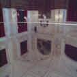
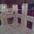
6 Fig. 7: Measured point in left panorama (top) and corresponding epipolar line in right image (bottom) Fig. 8: Location of epipolar lines at almost horizontal object edges 4. Example applications 4.1 3D model of entrance hall The university main entrance hall has served as a test object for 3D modelling from panorama images. The dimensions of the hall are about 25m x 25m x 8m. It consists of a number of arcs that form the arcades on three sides of the hall. Four panorama images have been generated based on high-resolution frame imagery (Kodak DCS 645M). The mean pixel size in object space results to about 2mm. For this example, 170 object points have been measured in order to provide basic geometry data for the 3D reconstruction. The average accuracy of object points measured by space intersection is estimated to about 5mm depending on geometrical intersection conditions. This result corresponds to an image accuracy of about 2 pixels. A higher accuracy of about 1 pixel can be expected if better calibration parameters of the Kodak camera were available. In this case, the camera has been calibrated a couple of days before the actual measurement. Fig. 9 shows the 3D wire frame model of the reconstructed hall. The data is processed by StereoMess, a software package developed in our institute.
 and the floor (bottom). Fig. 10: rthophotos generated from panorama imagery 4.")
.")
.")
7 Fig. 9: 3D model of the entrance hall Using the parameters of interior and exterior orientation, orthophotos can be calculated from the panorama image. Fig. 10 shows two examples where the image is projected onto a wall of the building (top) and the floor (bottom). Fig. 10: rthophotos generated from panorama imagery 4.2 Multiple image panorama mosaic The Great Hall of the ldenburg castle has been surveyed within a student s project. Again, the Kodak DCS 645M camera was used to acquire four panoramas located close to the four corners of the hall (Fig. 12). ne additional panorama has been taken from the centre of the hall in order to provide image data for a high-quality panorama presentation of the interior. A number of control points have been measured by non-contact tachymetry. Each panorama originally consists of 10 frame images (Fig. 11). Based on calibrated camera data and a number of tie points measured in the overlapping zones of each image, four panoramas are generated that are located in the corners of the hall (Fig. 12). Finally, the complete panorama, with a virtual station in the centre of the hall, could be resampled (Fig. 13). The final panorama image has a resolution of about x 5300 pixels.


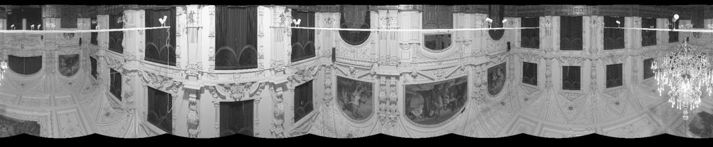
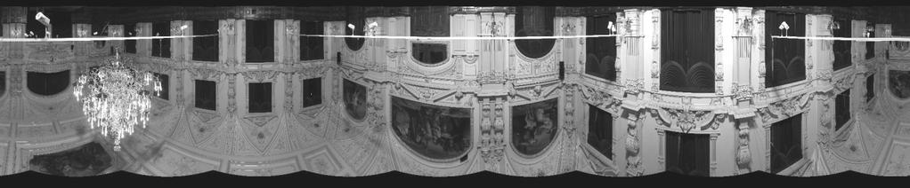
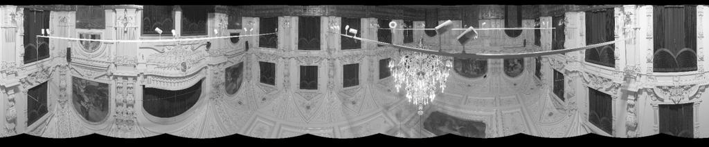
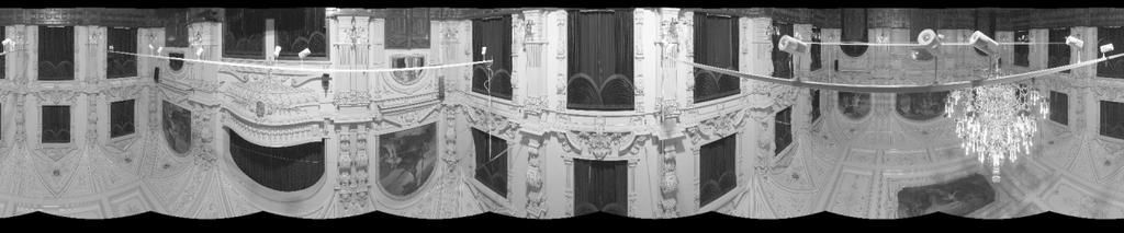
8 Fig. 11: riginal images of one panorama station Fig. 12: Four measurement panoramas (cameras stations in hall corners)

 have been used.")
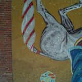
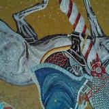
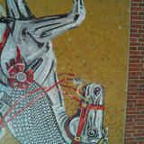
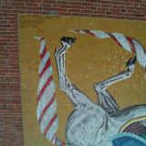
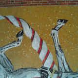
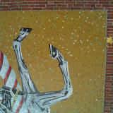
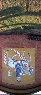
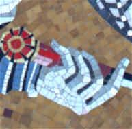
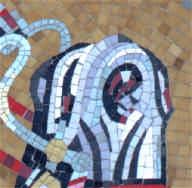
9 Fig. 13: Resulting panorama of Great Hall (camera station in hall center) 4.3 Plane rectification This project is a comparison of two approaches for high-definition rectification of planar objects, such as historic mosaics or paintings. The objective is to achieve not only a high-resolution document of the object, but also high quality in terms of colour correctness and geometric accuracy. For this investigation again the two high-resolution digital cameras (Fig. 1 and Fig. 2) have been used. An artwork showing ldenburg's Graf Anton Günther ( ) has been created in 1959 and is located on the outside wall of a school. The desired resolution of the image rectification is specified to 1mm in object space. Fig. 14: Wall mosaic A set of nine images has been recorded that covers the complete object with an overlap of about 20-30% (Fig. 15). A number of control points have been measured by a theodolite. Each image of the set was rectified by plane projective transformation. The final orthoimage results from a mosaicing process where each rectified image has been stitched without colour adjustment (Fig. 17 left).

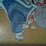
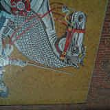
10 Fig. 15: Set of nine high-resolution images (each 4000 x 4000 pixels) Fig. 16: Sector panorama image and example details
. 5. Summary a) Image mosaic b) Rectified panorama image Fig.")

11 Parallel to the image acquisition by a normal digital camera, the KST panorama camera has been applied. In this case, only a sector panorama of about 30 has been recorded. The image was oriented by space resection and rectified by ortho-projection to the plane of the object (Fig. 17 right). 5. Summary a) Image mosaic b) Rectified panorama image Fig. 17: Rectified results The paper presents some examples and techniques for the use of panoramic images for architectural photogrammetry. Panorama images can be acquired quite easily by any type of modern digital camera. However, special notice must be given to geometric camera calibration if precise panoramas and/or photogrammetric products shall be achieved. In addition to standard calibration parameters, panorama adapters have to be adjusted in order to ensure alignment of the rotation axis and the perspective centre of the camera. The mathematical model of panorama images is usually based on cylindrical coordinates. Since collinearity equations can be derived easily, all standard photogrammetric algorithms from space intersection to bundle adjustment can be applied. Three practical examples are given in the paper. For documentation purposes, panoramas are most useful inside rooms where an all-around image is desired. Panorama images can be acquired with very high image resolution and colour quality, so that the image is a valuable document of the object. For 3D modeling purposes panoramas have the advantage that only a very limited number of tie points have to be measured. As a drawback, only very few software packages are available that can handle panorama images for photogrammetric purposes. 6. References Amiri Parian, J, Gruen, A. (2005): A refined sensor model for panoramic cameras. International Archives of Photogrammetry, Remote Sensing and Spatial Information Sciences, Vol. XXXIV, Part 5/W16.
12 Chapman, D., Kotowski, R., 2000: Methodology for the Construction of Large Image Archives of Complex Industrial Structures. Publikationen der DGPF, Band 8, Essen Heikkinen, J. (2002): Performance of circular image blocks in close-range photogrammetry. ISPRS Symposium Comm. V, Korfu, Luhmann, T., Tecklenburg, W. (2002): Bundle orientation and 3-D object reconstruction from multiple-station panoramic imagery. ISPRS Symposium Comm. V, Korfu, Luhmann, T., Tecklenburg, W., 2003: Potential of panoramic views generated from high-resolution frame images and rotating line scanner images. Grün/Kahmen (eds.): ptical 3-D Measurement Techniques, ETH Zürich, pp Luhmann, T. (2005): A historical review on panorama imagery. International Archives of Photogrammetry, Remote Sensing and Spatial Information Sciences, Vol. XXXIV, Part 5/W16. Petsa, E., Kouroupis, S., Karras, G.E. (2001): Inserting the past in video sequences. International Archives of Photogrammetry, Remote Sensing and Spatial Information Systems, Vol. XXXIV-5C7, pp Scheele, M, Börner, A., Reulke, R., Scheibe, K. (2001): Geometrische Korrekturen: Vom Flugzeugscanner zur Nahbereichskamera. Photogrammetrie-Fernerkundung-Geoinformation, Heft 1, 2001, pp Schneider, D., Maas, H.-G. (2003): Geometrische Modellierung und Kalibrierung einer hochauflösenden digitalen Rotations zeilen kamera. Luhmann (ed.): "Photogrammetrie Laserscanning - ptische 3D-Messtechnik", Wichmann Verlag, 2003 Schneider, D., Maas, H.-G. (2005): Application and accuracy potential of a strict geometric model for rotating line cameras. International Archives of Photogrammetry, Remote Sensing and Spatial Information Sciences, Vol. XXXIV, Part 5/W16. View publication stats
3-D OBJECT RECONSTRUCTION FROM MULTIPLE-STATION PANORAMA IMAGERY
 3-D BJECT RECNSTRUCTIN FRM MULTIPLE-STATIN PANRAMA IMAGERY Thomas Luhmann, Werner Tecklenburg University of Applied Sciences, Institute for Applied Photogrammetry and Geoinformatics, fener Str. 16, D-26121
APPLICATION AND ACCURACY POTENTIAL OF A STRICT GEOMETRIC MODEL FOR ROTATING LINE CAMERAS
 APPLICATION AND ACCURACY POTENTIAL OF A STRICT GEOMETRIC MODEL FOR ROTATING LINE CAMERAS D. Schneider, H.-G. Maas Dresden University of Technology Institute of Photogrammetry and Remote Sensing Mommsenstr.
DEVELOPMENT AND APPLICATION OF AN EXTENDED GEOMETRIC MODEL FOR HIGH RESOLUTION PANORAMIC CAMERAS
 DEVELOPMENT AND APPLICATION OF AN EXTENDED GEOMETRIC MODEL FOR HIGH RESOLUTION PANORAMIC CAMERAS D. Schneider, H.-G. Maas Dresden University of Technology Institute of Photogrammetry and Remote Sensing
INSERTING THE PAST IN VIDEO SEQUENCES
 INSERTING THE PAST IN VIDEO SEQUENCES Elli Petsa, Stefanos Kouroupis Department of Surveying, Technological Educational Institute of Athens GR-12210 Athens, Greece (e-mail: petsa@teiath.gr) George Karras
KEY WORDS: Animation, Architecture, Image Rectification, Multi-Media, Texture Mapping, Visualization
 AUTOMATED PROCESSING OF DIGITAL IMAGE DATA IN ARCHITECTURAL SURVEYING Günter Pomaska Prof. Dr.-Ing., Faculty of Architecture and Civil Engineering FH Bielefeld, University of Applied Sciences Artilleriestr.
AUTOMATED PROCESSING OF DIGITAL IMAGE DATA IN ARCHITECTURAL SURVEYING
 International Archives of Photogrammetry and Remote Sensing. Vol. XXXII, Part 5. Hakodate 1998 AUTOMATED PROCESSING OF DIGITAL IMAGE DATA IN ARCHITECTURAL SURVEYING Gunter Pomaska Prof. Dr.-lng., Faculty
ON THE CREATION OF PANORAMIC IMAGES FROM IMAGE SEQUENCES
 ON THE CREATION OF PANORAMIC IMAGES FROM IMAGE SEQUENCES Petteri PÖNTINEN Helsinki University of Technology, Institute of Photogrammetry and Remote Sensing, Finland petteri.pontinen@hut.fi KEY WORDS: Cocentricity,
Desktop - Photogrammetry and its Link to Web Publishing
 Desktop - Photogrammetry and its Link to Web Publishing Günter Pomaska FH Bielefeld, University of Applied Sciences Bielefeld, Germany, email gp@imagefact.de Key words: Photogrammetry, image refinement,
Technical information about PhoToPlan
 Technical information about PhoToPlan The following pages shall give you a detailed overview of the possibilities using PhoToPlan. kubit GmbH Fiedlerstr. 36, 01307 Dresden, Germany Fon: +49 3 51/41 767
Aerial photography: Principles. Frame capture sensors: Analog film and digital cameras
 Aerial photography: Principles Frame capture sensors: Analog film and digital cameras Overview Introduction Frame vs scanning sensors Cameras (film and digital) Photogrammetry Orthophotos Air photos are
Geometry of Aerial Photographs
 Geometry of Aerial Photographs Aerial Cameras Aerial cameras must be (details in lectures): Geometrically stable Have fast and efficient shutters Have high geometric and optical quality lenses They can
ATTEMPTS TO AUTOMATE THE PROCESS OF GENERATION OF ORTHOIMAGES OF OBJECTS OF CULTURAL HERITAGE
 ATTEMPTS TO AUTOMATE THE PROCESS OF GENERATION OF ORTHOIMAGES OF OBJECTS OF CULTURAL HERITAGE J.S. Markiewicz a*, P. Podlasiak a, D. Zawieska a a Faculty of Geodesy and Cartography, Institute of Photogrammetry,
PROPERTY OF THE LARGE FORMAT DIGITAL AERIAL CAMERA DMC II
 PROPERTY OF THE LARGE FORMAT DIGITAL AERIAL CAMERA II K. Jacobsen a, K. Neumann b a Institute of Photogrammetry and GeoInformation, Leibniz University Hannover, Germany jacobsen@ipi.uni-hannover.de b Z/I
CLOSE RANGE ORTHOIMAGE USING A LOW COST DIGITAL CAMCORDER
 CLOSE RANGE ORTHOIMAGE USING A LOW COST DIGITAL CAMCORDER E. Tsiligiris a, M. Papakosta a, C. Ioannidis b, A. Georgopoulos c a Surveying Engineer, Post-graduate Student, National Technical University of
Digital deformation model for fisheye image rectification
 Digital deformation model for fisheye image rectification Wenguang Hou, 1 Mingyue Ding, 1 Nannan Qin, 2 and Xudong Lai 2, 1 Department of Bio-medical Engineering, Image Processing and Intelligence Control
Digital Photogrammetry. Presented by: Dr. Hamid Ebadi
 Digital Photogrammetry Presented by: Dr. Hamid Ebadi Background First Generation Analog Photogrammetry Analytical Photogrammetry Digital Photogrammetry Photogrammetric Generations 2000 digital photogrammetry
CALIBRATION OF IMAGING SATELLITE SENSORS
 CALIBRATION OF IMAGING SATELLITE SENSORS Jacobsen, K. Institute of Photogrammetry and GeoInformation, University of Hannover jacobsen@ipi.uni-hannover.de KEY WORDS: imaging satellites, geometry, calibration
MINIMISING SYSTEMATIC ERRORS IN DEMS CAUSED BY AN INACCURATE LENS MODEL
 MINIMISING SYSTEMATIC ERRORS IN DEMS CAUSED BY AN INACCURATE LENS MODEL R. Wackrow a, J.H. Chandler a and T. Gardner b a Dept. Civil and Building Engineering, Loughborough University, LE11 3TU, UK (r.wackrow,
Beacon Island Report / Notes
 Beacon Island Report / Notes Paul Bourke, ivec@uwa, 17 February 2014 During my 2013 and 2014 visits to Beacon Island four general digital asset categories were acquired, they were: high resolution panoramic
CALIBRATION OF OPTICAL SATELLITE SENSORS
 CALIBRATION OF OPTICAL SATELLITE SENSORS KARSTEN JACOBSEN University of Hannover Institute of Photogrammetry and Geoinformation Nienburger Str. 1, D-30167 Hannover, Germany jacobsen@ipi.uni-hannover.de
Image stitching. Image stitching. Video summarization. Applications of image stitching. Stitching = alignment + blending. geometrical registration
 Image stitching Stitching = alignment + blending Image stitching geometrical registration photometric registration Digital Visual Effects, Spring 2006 Yung-Yu Chuang 2005/3/22 with slides by Richard Szeliski,
HD aerial video for coastal zone ecological mapping
 HD aerial video for coastal zone ecological mapping Albert K. Chong University of Otago, Dunedin, New Zealand Phone: +64 3 479-7587 Fax: +64 3 479-7586 Email: albert.chong@surveying.otago.ac.nz Presented
2019 NYSAPLS Conf> Fundamentals of Photogrammetry for Land Surveyors
 2019 NYSAPLS Conf> Fundamentals of Photogrammetry for Land Surveyors George Southard GSKS Associates LLC Introduction George Southard: Master s Degree in Photogrammetry and Cartography 40 years working
Reconstructing Virtual Rooms from Panoramic Images
 Reconstructing Virtual Rooms from Panoramic Images Dirk Farin, Peter H. N. de With Contact address: Dirk Farin Eindhoven University of Technology (TU/e) Embedded Systems Institute 5600 MB, Eindhoven, The
Sample Copy. Not For Distribution.
 Photogrammetry, GIS & Remote Sensing Quick Reference Book i EDUCREATION PUBLISHING Shubham Vihar, Mangla, Bilaspur, Chhattisgarh - 495001 Website: www.educreation.in Copyright, 2017, S.S. Manugula, V.
SCIENCE & TECHNOLOGY
 Pertanika J. Sci. & Technol. 21 (2): 387-396 (2013) SCIENCE & TECHNOLOGY Journal homepage: http://www.pertanika.upm.edu.my/ Production of Orthophoto and Volume Determination Using Low-Cost Digital Cameras
ENVI Tutorial: Orthorectifying Aerial Photographs
 ENVI Tutorial: Orthorectifying Aerial Photographs Table of Contents OVERVIEW OF THIS TUTORIAL...2 ORTHORECTIFYING AERIAL PHOTOGRAPHS IN ENVI...2 Building the interior orientation...3 Building the exterior
RESULTS OF 3D PHOTOGRAMMETRY ON THE CMS BARREL YOKE
 RESULTS OF 3D PHOTOGRAMMETRY ON THE CMS BARREL YOKE R. GOUDARD, C. HUMBERTCLAUDE *1, K. NUMMIARO CERN, European Laboratory for Particle Physics, Geneva, Switzerland 1. INTRODUCTION Compact Muon Solenoid
Processing of stereo scanner: from stereo plotter to pixel factory
 Photogrammetric Week '03 Dieter Fritsch (Ed.) Wichmann Verlag, Heidelberg, 2003 Bignone 141 Processing of stereo scanner: from stereo plotter to pixel factory FRANK BIGNONE, ISTAR, France ABSTRACT With
High Resolution Sensor Test Comparison with SPOT, KFA1000, KVR1000, IRS-1C and DPA in Lower Saxony
 High Resolution Sensor Test Comparison with SPOT, KFA1000, KVR1000, IRS-1C and DPA in Lower Saxony K. Jacobsen, G. Konecny, H. Wegmann Abstract The Institute for Photogrammetry and Engineering Surveys
[GEOMETRIC CORRECTION, ORTHORECTIFICATION AND MOSAICKING]
![[GEOMETRIC CORRECTION, ORTHORECTIFICATION AND MOSAICKING]](/thumbs/78/78211997.jpg "[GEOMETRIC CORRECTION, ORTHORECTIFICATION AND MOSAICKING]") 2013 Ogis-geoInfo Inc. IBEABUCHI NKEMAKOLAM.J [GEOMETRIC CORRECTION, ORTHORECTIFICATION AND MOSAICKING] [Type the abstract of the document here. The abstract is typically a short summary of the contents
2013 Ogis-geoInfo Inc. IBEABUCHI NKEMAKOLAM.J [GEOMETRIC CORRECTION, ORTHORECTIFICATION AND MOSAICKING] [Type the abstract of the document here. The abstract is typically a short summary of the contents
Panoramic imaging. Ixyzϕθλt. 45 degrees FOV (normal view)
") Camera projections Recall the plenoptic function: Panoramic imaging Ixyzϕθλt (,,,,,, ) At any point xyz,, in space, there is a full sphere of possible incidence directions ϕ, θ, covered by 0 ϕ 2π, 0 θ
Camera projections Recall the plenoptic function: Panoramic imaging Ixyzϕθλt (,,,,,, ) At any point xyz,, in space, there is a full sphere of possible incidence directions ϕ, θ, covered by 0 ϕ 2π, 0 θ
EXPERIMENT ON PARAMETER SELECTION OF IMAGE DISTORTION MODEL
 IARS Volume XXXVI, art 5, Dresden 5-7 September 006 EXERIMENT ON ARAMETER SELECTION OF IMAGE DISTORTION MODEL Ryuji Matsuoa*, Noboru Sudo, Hideyo Yootsua, Mitsuo Sone Toai University Research & Information
Section 2 Image quality, radiometric analysis, preprocessing
 Section 2 Image quality, radiometric analysis, preprocessing Emmanuel Baltsavias Radiometric Quality (refers mostly to Ikonos) Preprocessing by Space Imaging (similar by other firms too): Modulation Transfer
EXAMPLES OF TOPOGRAPHIC MAPS PRODUCED FROM SPACE AND ACHIEVED ACCURACY CARAVAN Workshop on Mapping from Space, Phnom Penh, June 2000
 EXAMPLES OF TOPOGRAPHIC MAPS PRODUCED FROM SPACE AND ACHIEVED ACCURACY CARAVAN Workshop on Mapping from Space, Phnom Penh, June 2000 Jacobsen, Karsten University of Hannover Email: karsten@ipi.uni-hannover.de
Lab #10 Digital Orthophoto Creation (Using Leica Photogrammetry Suite)
") Lab #10 Digital Orthophoto Creation (Using Leica Photogrammetry Suite) References: Leica Photogrammetry Suite Project Manager: Users Guide, Leica Geosystems LLC. Leica Photogrammetry Suite 9.2 Introduction:
Lab #10 Digital Orthophoto Creation (Using Leica Photogrammetry Suite) References: Leica Photogrammetry Suite Project Manager: Users Guide, Leica Geosystems LLC. Leica Photogrammetry Suite 9.2 Introduction:
Single Camera Catadioptric Stereo System
 Single Camera Catadioptric Stereo System Abstract In this paper, we present a framework for novel catadioptric stereo camera system that uses a single camera and a single lens with conic mirrors. Various
switzerland Commission II, ISPRS Kyoto, July 1988
 TOWARDS THE DIGITAL FUTURE stefan Lutz Kern & CO.., Ltd 5000 Aarau switzerland Commission II, ISPRS Kyoto, July 1988 ABSTRACT The equipping of the Kern Digital stereo Restitution Instrument (DSR) with
CALIBRATION OF AN AMATEUR CAMERA FOR VARIOUS OBJECT DISTANCES
 CALIBRATION OF AN AMATEUR CAMERA FOR VARIOUS OBJECT DISTANCES Sanjib K. Ghosh, Monir Rahimi and Zhengdong Shi Laval University 1355 Pav. Casault, Laval University QUEBEC G1K 7P4 CAN A D A Commission V
ENHANCEMENT OF THE RADIOMETRIC IMAGE QUALITY OF PHOTOGRAMMETRIC SCANNERS.
 ENHANCEMENT OF THE RADIOMETRIC IMAGE QUALITY OF PHOTOGRAMMETRIC SCANNERS Klaus NEUMANN *, Emmanuel BALTSAVIAS ** * Z/I Imaging GmbH, Oberkochen, Germany neumann@ziimaging.de ** Institute of Geodesy and
VisionMap Sensors and Processing Roadmap
 Vilan, Gozes 51 VisionMap Sensors and Processing Roadmap YARON VILAN, ADI GOZES, Tel-Aviv ABSTRACT The A3 is a family of digital aerial mapping cameras and photogrammetric processing systems, which is
Camera Calibration Certificate No: DMC III 27542
 Calibration DMC III Camera Calibration Certificate No: DMC III 27542 For Peregrine Aerial Surveys, Inc. #201 1255 Townline Road Abbotsford, B.C. V2T 6E1 Canada Calib_DMCIII_27542.docx Document Version
D. Hunter, J. Smart Kern & Co.., Ltd 5000 Aarau switzerland Commission II, ISPRS Kyoto, July 1988
 IMAGE ORIENTATION ON THE KERN DSR D. Hunter, J. Smart Kern & Co.., Ltd 5000 Aarau switzerland Commission II, ISPRS Kyoto, July 1988 Abstract A description of the possible image orientation capabilities
DOCUMENTATION AND DEVELOPMENT OF THE COLUMNS OF THE CHURCH OF ST. CHARLES IN VIENNA
 DOCUMENTATION AND DEVELOPMENT OF THE COLUMNS OF THE CHURCH OF ST. CHARLES IN VIENNA C. Ressl a,, K. Kraus a, W. Höppl b a Institute of Photogrammetry and Remote Sensing, TU Vienna, Gusshausstrasse 27-29/E122,
Some Enhancement in Processing Aerial Videography Data for 3D Corridor Mapping
 Some Enhancement in Processing Aerial Videography Data for 3D Corridor Mapping Catur Aries ROKHMANA, Indonesia Key words: 3D corridor mapping, aerial videography, point-matching, sub-pixel enhancement,
Camera Calibration Certificate No: DMC II
 Calibration DMC II 140-036 Camera Calibration Certificate No: DMC II 140-036 For Midwest Aerial Photography 7535 West Broad St, Galloway, OH 43119 USA Calib_DMCII140-036.docx Document Version 3.0 page
CSI: Rombalds Moor Photogrammetry Photography
 Photogrammetry Photography Photogrammetry Training 26 th March 10:00 Welcome Presentation image capture Practice 12:30 13:15 Lunch More practice 16:00 (ish) Finish or earlier What is photogrammetry 'photo'
Camera Calibration Certificate No: DMC II
 Calibration DMC II 230 015 Camera Calibration Certificate No: DMC II 230 015 For Air Photographics, Inc. 2115 Kelly Island Road MARTINSBURG WV 25405 USA Calib_DMCII230-015_2014.docx Document Version 3.0
Image Mosaicing. Jinxiang Chai. Source: faculty.cs.tamu.edu/jchai/cpsc641_spring10/lectures/lecture8.ppt
 CSCE 641 Computer Graphics: Image Mosaicing Jinxiang Chai Source: faculty.cs.tamu.edu/jchai/cpsc641_spring10/lectures/lecture8.ppt Outline Image registration - How to break assumptions? 3D-2D registration
Camera Calibration Certificate No: DMC II
 Calibration DMC II 140-005 Camera Calibration Certificate No: DMC II 140-005 For Midwest Aerial Photography 7535 West Broad St, Galloway, OH 43119 USA Calib_DMCII140-005.docx Document Version 3.0 page
CanImage. (Landsat 7 Orthoimages at the 1: Scale) Standards and Specifications Edition 1.0
 Standards and Specifications Edition 1.0") CanImage (Landsat 7 Orthoimages at the 1:50 000 Scale) Standards and Specifications Edition 1.0 Centre for Topographic Information Customer Support Group 2144 King Street West, Suite 010 Sherbrooke, QC
CanImage (Landsat 7 Orthoimages at the 1:50 000 Scale) Standards and Specifications Edition 1.0 Centre for Topographic Information Customer Support Group 2144 King Street West, Suite 010 Sherbrooke, QC
Metric Accuracy Testing with Mobile Phone Cameras
 Metric Accuracy Testing with Mobile Phone Cameras Armin Gruen,, Devrim Akca Chair of Photogrammetry and Remote Sensing ETH Zurich Switzerland www.photogrammetry.ethz.ch Devrim Akca, the 21. ISPRS Congress,
CALIBRATION REPORT SUMMARY
 CALIBRATION REPORT SUMMARY Material Description Assembly 2PADI080 1027 0997 A / 09A Camera Module 1 CCD KODAK KAF 39Mp Full Frame Color Image Sensor SN CQ011027 Lens Schneider Apo Digitar 4.0/80 N SN 15006871
Automated Photogrammetry with PHODIS
 'Photogrammetric Week '97' D. Fritsch D. Hobbie, Eds., Wichmann Verlag, Heidelberg, 1997. Braun 33 Automated Photogrammetry with PHODIS JOSEF BRAUN, Oberkochen ABSTRACT This paper describes the PHODIS
Colour correction for panoramic imaging
 Colour correction for panoramic imaging Gui Yun Tian Duke Gledhill Dave Taylor The University of Huddersfield David Clarke Rotography Ltd Abstract: This paper reports the problem of colour distortion in
ELIMINATION OF COLOR FRINGES IN DIGITAL PHOTOGRAPHS CAUSED BY LATERAL CHROMATIC ABERRATION
 ELIMINATION OF COLOR FRINGES IN DIGITAL PHOTOGRAPHS CAUSED BY LATERAL CHROMATIC ABERRATION V. Kaufmann, R. Ladstädter Institute of Remote Sensing and Photogrammetry Graz University of Technology, Austria
CALIBRATING THE NEW ULTRACAM OSPREY OBLIQUE AERIAL SENSOR Michael Gruber, Wolfgang Walcher
 CALIBRATING THE NEW ULTRACAM OSPREY OBLIQUE AERIAL SENSOR Michael Gruber, Wolfgang Walcher Microsoft UltraCam Business Unit Anzengrubergasse 8/4, 8010 Graz / Austria {michgrub, wwalcher}@microsoft.com
INTEGRATED DEM AND PAN-SHARPENED SPOT-4 IMAGE IN URBAN STUDIES
 INTEGRATED DEM AND PAN-SHARPENED SPOT-4 IMAGE IN URBAN STUDIES G. Doxani, A. Stamou Dept. Cadastre, Photogrammetry and Cartography, Aristotle University of Thessaloniki, GREECE gdoxani@hotmail.com, katerinoudi@hotmail.com
Volume 1 - Module 6 Geometry of Aerial Photography. I. Classification of Photographs. Vertical
 RSCC Volume 1 Introduction to Photo Interpretation and Photogrammetry Table of Contents Module 1 Module 2 Module 3.1 Module 3.2 Module 4 Module 5 Module 6 Module 7 Module 8 Labs Volume 1 - Module 6 Geometry
NON-METRIC BIRD S EYE VIEW
 NON-METRIC BIRD S EYE VIEW Prof. A. Georgopoulos, M. Modatsos Lab. of Photogrammetry, Dept. of Rural & Surv. Engineering, National Technical University of Athens, 9, Iroon Polytechniou, GR-15780 Greece
Lesson 4: Photogrammetry
 This work by the National Information Security and Geospatial Technologies Consortium (NISGTC), and except where otherwise Development was funded by the Department of Labor (DOL) Trade Adjustment Assistance
Camera Calibration Certificate No: DMC II
 Calibration DMC II 230 027 Camera Calibration Certificate No: DMC II 230 027 For Peregrine Aerial Surveys, Inc. 103-20200 56 th Ave Langley, BC V3A 8S1 Canada Calib_DMCII230-027.docx Document Version 3.0
Camera Calibration Certificate No: DMC II Aero Photo Europe Investigation
 Calibration DMC II 250 030 Camera Calibration Certificate No: DMC II 250 030 For Aero Photo Europe Investigation Aerodrome de Moulins Montbeugny Yzeure Cedex 03401 France Calib_DMCII250-030.docx Document
Camera Calibration Certificate No: DMC IIe
 Calibration DMC IIe 230 23522 Camera Calibration Certificate No: DMC IIe 230 23522 For Richard Crouse & Associates 467 Aviation Way Frederick, MD 21701 USA Calib_DMCIIe230-23522.docx Document Version 3.0
Digital Photographic Imaging Using MOEMS
 Digital Photographic Imaging Using MOEMS Vasileios T. Nasis a, R. Andrew Hicks b and Timothy P. Kurzweg a a Department of Electrical and Computer Engineering, Drexel University, Philadelphia, USA b Department
Camera Calibration Certificate No: DMC II
 Calibration DMC II 230 020 Camera Calibration Certificate No: DMC II 230 020 For MGGP Aero Sp. z o.o. ul. Słowackiego 33-37 33-100 Tarnów Poland Calib_DMCII230-020.docx Document Version 3.0 page 1 of 40
GEOMETRIC RECTIFICATION OF EUROPEAN HISTORICAL ARCHIVES OF LANDSAT 1-3 MSS IMAGERY
 GEOMETRIC RECTIFICATION OF EUROPEAN HISTORICAL ARCHIVES OF LANDSAT -3 MSS IMAGERY Torbjörn Westin Satellus AB P.O.Box 427, SE-74 Solna, Sweden tw@ssc.se KEYWORDS: Landsat, MSS, rectification, orbital model
Baldwin and Mobile Counties, AL Orthoimagery Project Report. Submitted: March 23, 2016
 2015 Orthoimagery Project Report Submitted: Prepared by: Quantum Spatial, Inc 523 Wellington Way, Suite 375 Lexington, KY 40503 859-277-8700 Page i of iii Contents Project Report 1. Summary / Scope...
PHOTOGRAMMETRIC APPLICATION OF SPHERICAL IMAGING
 PHOTOGRAMMETRIC APPLICATION OF SPHERICAL IMAGING H. Haggrén a *, H. Hyyppä a, O. Jokinen a, A. Kukko b, M. Nuikka a, T. Pitkänen a, P. Pöntinen a, P. Rönnholm a a Institute of Photogrammetry and Remote
ASPECTS OF DEM GENERATION FROM UAS IMAGERY
 ASPECTS OF DEM GENERATION FROM UAS IMAGERY A. Greiwea,, R. Gehrke a,, V. Spreckels b,, A. Schlienkamp b, Department Architecture, Civil Engineering and Geomatics, Fachhochschule Frankfurt am Main, Germany
TELLS THE NUMBER OF PIXELS THE TRUTH? EFFECTIVE RESOLUTION OF LARGE SIZE DIGITAL FRAME CAMERAS
 TELLS THE NUMBER OF PIXELS THE TRUTH? EFFECTIVE RESOLUTION OF LARGE SIZE DIGITAL FRAME CAMERAS Karsten Jacobsen Leibniz University Hannover Nienburger Str. 1 D-30167 Hannover, Germany jacobsen@ipi.uni-hannover.de
1. Introduction 2. Tectonics of NE Iceland Krafla rifting crisis (constraints from spy image matching)
") 1. Introduction 2. Tectonics of NE Iceland 3. 1975-1984 Krafla rifting crisis (constraints from spy image matching) 4. 1975-1984 Krafla rifting crisis (constraints from aerial photos) 5. Conclusions Tuesday
1. Introduction 2. Tectonics of NE Iceland 3. 1975-1984 Krafla rifting crisis (constraints from spy image matching) 4. 1975-1984 Krafla rifting crisis (constraints from aerial photos) 5. Conclusions Tuesday
Basics of Photogrammetry Note#6
 Basics of Photogrammetry Note#6 Photogrammetry Art and science of making accurate measurements by means of aerial photography Analog: visual and manual analysis of aerial photographs in hard-copy format
Application of GIS for earthquake hazard and risk assessment: Kathmandu, Nepal. Part 2: Data preparation GIS CASE STUDY
 GIS CASE STUDY Application of GIS for earthquake hazard and risk assessment: Kathmandu, Nepal Part 2: Data preparation Cees van Westen (E-mail : westen@itc.nl) Siefko Slob (E-mail: Slob@itc.nl) Lorena
CALIBRATION OF THE LH SYSTEMS ADS40 AIRBORNE DIGITAL SENSOR
 CALIBRATION OF THE LH SYSTEMS ADS4 AIRBORNE DIGITAL SENSOR Reinhard SCHUSTER*, Bernhard BRAUNECKER** *Deutsches Zentrum für Luft- und Raumfahrt (DLR), Germany Institute of Space Sensor Technology and Planetary
UltraCam Eagle Prime Aerial Sensor Calibration and Validation
 UltraCam Eagle Prime Aerial Sensor Calibration and Validation Michael Gruber, Marc Muick Vexcel Imaging GmbH Anzengrubergasse 8/4, 8010 Graz / Austria {michael.gruber, marc.muick}@vexcel-imaging.com Key
Phase One ixu-rs1000 Accuracy Assessment Report Yu. Raizman, PhaseOne.Industrial, Israel
 17 th International Scientific and Technical Conference FROM IMAGERY TO DIGITAL REALITY: ERS & Photogrammetry Phase One ixu-rs1000 Accuracy Assessment Report Yu. Raizman, PhaseOne.Industrial, Israel 1.
CSC 170 Introduction to Computers and Their Applications. Lecture #3 Digital Graphics and Video Basics. Bitmap Basics
 CSC 170 Introduction to Computers and Their Applications Lecture #3 Digital Graphics and Video Basics Bitmap Basics As digital devices gained the ability to display images, two types of computer graphics
MULTIPLE SENSORS LENSLETS FOR SECURE DOCUMENT SCANNERS
 INFOTEH-JAHORINA Vol. 10, Ref. E-VI-11, p. 892-896, March 2011. MULTIPLE SENSORS LENSLETS FOR SECURE DOCUMENT SCANNERS Jelena Cvetković, Aleksej Makarov, Sasa Vujić, Vlatacom d.o.o. Beograd Abstract -
PERFORMANCE EVALUATIONS OF MACRO LENSES FOR DIGITAL DOCUMENTATION OF SMALL OBJECTS
 PERFORMANCE EVALUATIONS OF MACRO LENSES FOR DIGITAL DOCUMENTATION OF SMALL OBJECTS ideharu Yanagi a, Yuichi onma b, irofumi Chikatsu b a Spatial Information Technology Division, Japan Association of Surveyors,
AN AUTOMATIC PROCESS FOR THE EXTRACTION OF THE 3D MODEL OF THE HUMAN BACK SURFACE FOR SCOLIOSIS TREATMENT
 AN AUTOMATIC PROCESS FOR THE EXTRACTION OF THE 3D MODEL OF THE HUMAN BACK SURFACE FOR SCOLIOSIS TREATMENT Lazaros SECHIDIS, Vassilios TSIOUKAS, Petros PATIAS The Aristotle University of Thessaloniki Department
Leica ADS80 - Digital Airborne Imaging Solution NAIP, Salt Lake City 4 December 2008
 Luzern, Switzerland, acquired at 5 cm GSD, 2008. Leica ADS80 - Digital Airborne Imaging Solution NAIP, Salt Lake City 4 December 2008 Shawn Slade, Doug Flint and Ruedi Wagner Leica Geosystems AG, Airborne
Automated GIS data collection and update
 Walter 267 Automated GIS data collection and update VOLKER WALTER, S tuttgart ABSTRACT This paper examines data from different sensors regarding their potential for an automatic change detection approach.
UltraCam and UltraMap Towards All in One Solution by Photogrammetry
 Photogrammetric Week '11 Dieter Fritsch (Ed.) Wichmann/VDE Verlag, Belin & Offenbach, 2011 Wiechert, Gruber 33 UltraCam and UltraMap Towards All in One Solution by Photogrammetry ALEXANDER WIECHERT, MICHAEL
APPLICATIONS OF PHOTOGRAMMETRIC AND COMPUTER VISION TECHNIQUES IN SHAKE TABLE TESTING
 13 th World Conference on Earthquake Engineering Vancouver, B.C., Canada August 1-6, 2004 Paper No. 3458 APPLICATIONS OF PHOTOGRAMMETRIC AND COMPUTER VISION TECHNIQUES IN SHAKE TABLE TESTING J.-A. BERALDIN
Sensors and Sensing Cameras and Camera Calibration
 Sensors and Sensing Cameras and Camera Calibration Todor Stoyanov Mobile Robotics and Olfaction Lab Center for Applied Autonomous Sensor Systems Örebro University, Sweden todor.stoyanov@oru.se 20.11.2014
Opto Engineering S.r.l.
 TUTORIAL #1 Telecentric Lenses: basic information and working principles On line dimensional control is one of the most challenging and difficult applications of vision systems. On the other hand, besides
DETERMINATION OF ST. GEORGE BASILICA TOWER HISTORICAL INCLINATION FROM CONTEMPORARY PHOTOGRAPH
 DETERMINATION OF ST. GEORGE BASILICA TOWER HISTORICAL INCLINATION FROM CONTEMPORARY PHOTOGRAPH Bronislav KOSKA 1 1 Czech Technical University in Prague, Faculty of Civil Engineering Thákurova 7, Prague
I-I. S/Scientific Report No. I. Duane C. Brown. C-!3 P.O0. Box 1226 Melbourne, Florida
 S AFCRL.-63-481 LOCATION AND DETERMINATION OF THE LOCATION OF THE ENTRANCE PUPIL -0 (CENTER OF PROJECTION) I- ~OF PC-1000 CAMERA IN OBJECT SPACE S Ronald G. Davis Duane C. Brown - L INSTRUMENT CORPORATION
RADIOMETRIC AND GEOMETRIC EVALUATION OF THE CAPABILITIES OF THE NEW AIRBORNE DIGITAL PHOTOGRAMMETRIC SENSORS
 RADIOMETRIC AND GEOMETRIC EVALUATION OF THE CAPABILITIES OF THE NEW AIRBORNE DIGITAL PHOTOGRAMMETRIC SENSORS D. Emmolo a, P. Orlando a, B. Villa a a Dipartimento di Rappresentazione, Università degli Studi
DEVELOPMENT OF IMAGE-BASED INFORMATION SYSTEM FOR RESTORATION OF CULTURAL HERITAGE
 Hongo, Kenji DEVELOPMENT OF IMAGE-BASED INFORMATION SYSTEM FOR RESTORATION OF CULTURAL HERITAGE Kenji Hongo*, Ryuji Matsuoka*, Seiju Fujiwara*, Katsuhiko Masuda** and Shigeo Aoki** * Kokusai Kogyo Co.,
UltraCam and UltraMap An Update
 Photogrammetric Week '13 Dieter Fritsch (Ed.) Wichmann/VDE Verlag, Belin & Offenbach, 2013 Wiechert 37 UltraCam and UltraMap An Update ALEXANDER WIECHERT, Graz ABSTRACT When UltraCam D was presented first
MSB Imagery Program FAQ v1
 MSB Imagery Program FAQ v1 (F)requently (A)sked (Q)uestions 9/22/2016 This document is intended to answer commonly asked questions related to the MSB Recurring Aerial Imagery Program. Table of Contents
APPLICATIONS AND LESSONS LEARNED WITH AIRBORNE MULTISPECTRAL IMAGING
 APPLICATIONS AND LESSONS LEARNED WITH AIRBORNE MULTISPECTRAL IMAGING James M. Ellis and Hugh S. Dodd The MapFactory and HJW Walnut Creek and Oakland, California, U.S.A. ABSTRACT Airborne digital frame
How to combine images in Photoshop
 How to combine images in Photoshop In Photoshop, you can use multiple layers to combine images, but there are two other ways to create a single image from mulitple images. Create a panoramic image with
Homographies and Mosaics
 Homographies and Mosaics Jeffrey Martin (jeffrey-martin.com) with a lot of slides stolen from Steve Seitz and Rick Szeliski 15-463: Computational Photography Alexei Efros, CMU, Fall 2011 Why Mosaic? Are
ifp Universität Stuttgart EuroSDR network on Digital Camera Calibration Report Phase I (Status Oct 26, 2004)
") Universität Stuttgart EuroSDR network on Digital Camera Calibration Report Phase I (Status Oct 26, 2004) Michael Cramer Institute for Photogrammetry (ifp) University of Stuttgart Geschwister-Scholl-Str.
Universität Stuttgart EuroSDR network on Digital Camera Calibration Report Phase I (Status Oct 26, 2004) Michael Cramer Institute for Photogrammetry (ifp) University of Stuttgart Geschwister-Scholl-Str.
remote sensing? What are the remote sensing principles behind these Definition
 Introduction to remote sensing: Content (1/2) Definition: photogrammetry and remote sensing (PRS) Radiation sources: solar radiation (passive optical RS) earth emission (passive microwave or thermal infrared
Homographies and Mosaics
 Homographies and Mosaics Jeffrey Martin (jeffrey-martin.com) CS194: Image Manipulation & Computational Photography with a lot of slides stolen from Alexei Efros, UC Berkeley, Fall 2014 Steve Seitz and
DIFFERENTIAL APPROACH FOR MAP REVISION FROM NEW MULTI-RESOLUTION SATELLITE IMAGERY AND EXISTING TOPOGRAPHIC DATA
 DIFFERENTIAL APPROACH FOR MAP REVISION FROM NEW MULTI-RESOLUTION SATELLITE IMAGERY AND EXISTING TOPOGRAPHIC DATA Costas ARMENAKIS Centre for Topographic Information - Geomatics Canada 615 Booth Str., Ottawa,