APPENDIX A Map Exhibits
|
|
|
- Felicity Stephany Watson
- 6 years ago
- Views:
Transcription
1 APPENDIX A Map Exhibits (See attached)

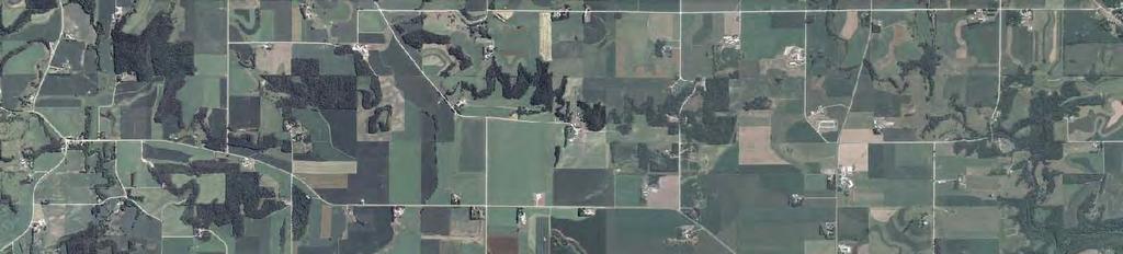


2 County Rd 0 County Rd 7 County Rd Map Document: (P:\007\gis\permit\Final\SPA_Exhibits\007doq0B_ex.mxd) 0// ::7 AM 00 Westwood Professional Services, Inc. Section Boundary 3th St. 3 County Hwy 3 30th St. 3 St. 0 State Hwy st Ave County Hwy County Hwy th St. Go Zu 00th St. Twp th St. US Hwy 0 7 State Hwy 0th St. 3 County Hwy Data Source(s): USDA AFPO NAIP (003), MnDNR PLSS (0), MnDOT Basemap (00), MnDOT Basemap (00), USGS NHD (00), ESRI Political Boundaries (006), Westwood (00). 0,00 Map EXHIBIT A-


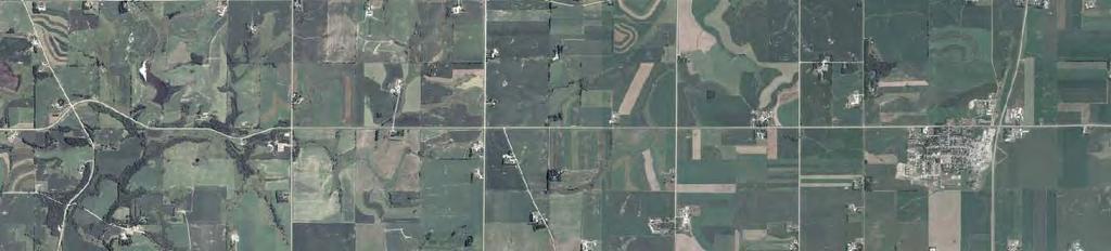
3 County Rd 0 County Rd 7 County Rd Map Document: (P:\007\gis\permit\Final\SPA_Exhibits\007drg0B_ex.mxd) 0//00 -- ::0 AM 00 Westwood Professional Services, Inc. Legend!( Section Boundary Recently Installed Communication Tower M MET Tower 3th St. Feathe Belle Creek County Hwy 3 Hay Creek 3 3 St. 0 30th St. State Hwy!( 3 M 0 3 st Ave County Hwy County Hwy th St th St. Twp. 3 6 US Hwy 0 0th St. 7 State Hwy 0th St. 3 Trout Brook County Hwy State Hwy 7 Wanamingo State Hwy 60 Data Source(s): MnDNR PLSS (0), MnDOT Basemap (00), USGS NHD (00), USGS DRG (00), ESRI Political Boundaries (006), Westwood (00). Miles 0 Location Map EXHIBIT A-


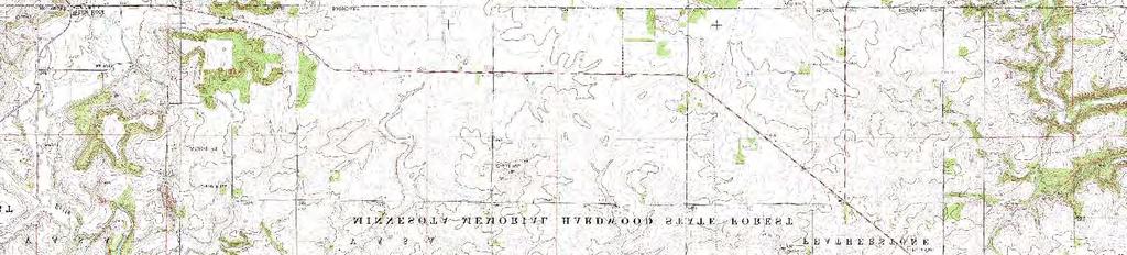
: USDA USGS Topography County")
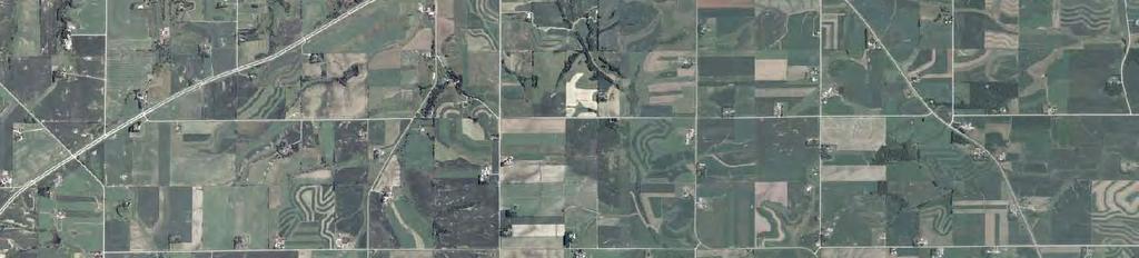
4 County Rd 0 County Rd 7 County Rd Map Document: (P:\007\gis\permit\Final\SPA_Exhibits\007turb0B_ex3.mxd) 0//00 -- :37:0 AM S 00 Westwood Professional Services, Inc. features Base Proposed Turbine Layout,00 ft Turbine Buffer M MET Tower Energy Infrastructure Natural Gas (Magellan) Section Boundary 3th St. S Vasa Substation S Substation Petroleum (BP/Amoco) Farm/Homesteads Transmission Lines S Existing Substations County Hwy 3 0 Miles Belle Creek 3 St th St. Hay Creek State Hwy 3 M 6 kv Xcel Energy 0 3 st Ave S County Hwy 3 County Hwy th St. 3 00th St. 3 kv Great River Energy Twp. 6 Trout Brook Go Zu 0th St. US Hwy 6 kv Xcel Energy 0 7 0th St. 3 State Hwy County Hwy Data Source(s): USDA USGS Topography County Mosaic (00), MnDNR PLSS (0), MnDOT Basemap (00), MnLMIC (00), USGS NHD (00), USFWS NWI (), ESRI Political Boundaries (006) PHMSA NPMS Pipeline Data (00), Westwood (00). 0,00 Preliminary Site Layout Map EXHIBIT A-3


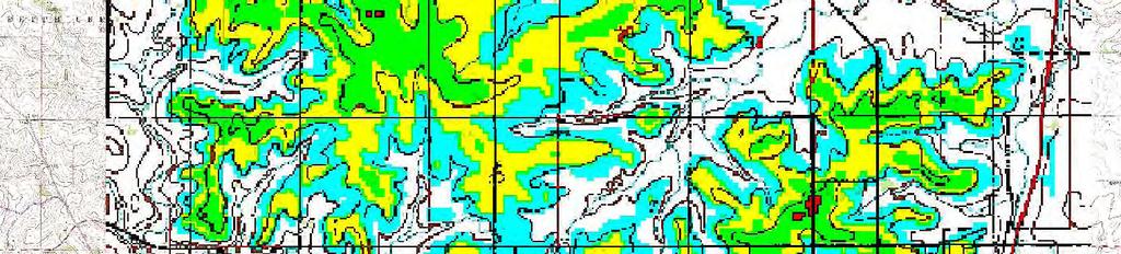
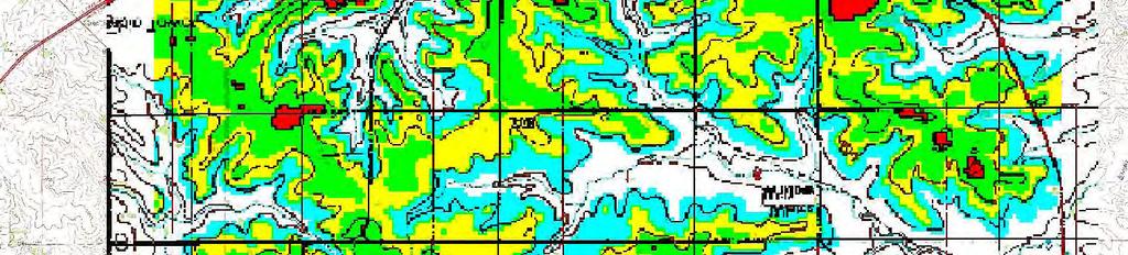
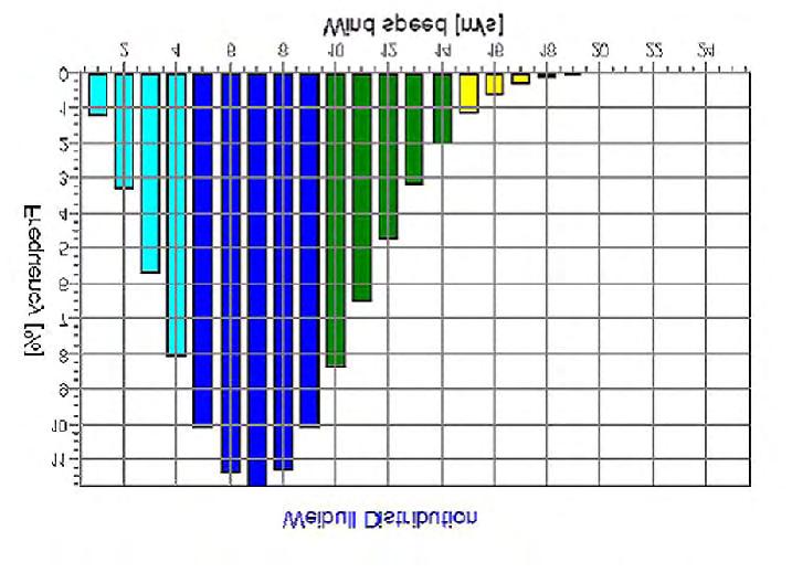
5 Map Document: (P:\007\gis\permit\Final\SPA_Exhibits\007drg0B_ex.mxd) 0//00 -- :3: PM 00 Westwood Professional Serv ices, Inc. Average Wind Speed m/s m/s m/s m/s m/s m/s County Rd 3th St. 3 County Hwy tt r y 0 w H 3 St. County Rd 7 Wh ea 30th St. St at e s 0 ta ve County Hwy th St y 3 Twp wy 0th St. te H Hw Z Sta County Rd 0 US 3 00th St. G 0th St. Data Source(s): USDA USGS Topo graphy Cou nty Mosaic ( 000), ESRI Political Boundaries (0 06), USGS NHD (00 ), Nation al Wind Assessments (0 0), Westwood ( 00). 3 County Hwy 0,00 Wind Speed Frequency Model and Wind Resource Map EXHIBIT A-


6 Map Document: (P:\007\gis\permit\Final\SPA_Exhibits\007wind0B_ex.mxd) 0//00 -- :: PM 00 Westwood Professional Services, Inc. Data from on-site MET Tower Data Source(s): National Wind Assessments (00), Westwood (00). Wind Energy Rose EXHIBIT A-
7 Map Document: (P:\007\gis\permit\Final\SPA_Exhibits\007wind0B_ex.mxd) 0//00 -- :: PM 00 Westwood Professional Services, Inc. Turbines by County 0 Anoka Wright Hennepin Hennepin FAA - Turbine AWEA - 0 Turbine Ramsey Washington Base FAA Federal Aviation Administration Obstructions Database 00 AWEA American Wind Energy Association Database 00 Carver Based on FAA 00 Obstruction DB Sibley Scott Dakota et Le Sueur Rice Rice FAA - Turbines AWEA - Turbines FAA - Turbine AWEA - 0 Turbine Wabasha Blue Earth Waseca Steele Dodge Dodge FAA - 6 Turbines AWEA - 0 Turbines Olmsted Faribault Faribault FAA - Turbines AWEA - Turbines Freeborn Mower Mower FAA - Turbines AWEA - 0 Existing Turbines Fillmore Data Source(s): FAA (00), AWEA (00), ESRI Political Boundaries (006), Westwood (00). Miles 0 0 Existing Wind Turbine Locations EXHIBIT A-6


: USDA USGS Topography")
, USFWS NWI (), ESRI Political Boundaries (006), General")
8 County Rd 0 County Rd 7 County Rd Map Document: (P:\007\gis\permit\Final\SPA_Exhibits\007wind0B_ex7.mxd) 0// ::33 AM 00 Westwood Professional Services, Inc. GE. xle Turbine Noise Model Level in db - Wind Pro.6.. Base Section Boundary Features + Proposed Turbine Layout M MET Tower Farm/Homesteads 3th St. 3 County Hwy 3 St th St. State Hwy 3 M 0 3 st Ave County Hwy 3 County Hwy th St. 3 Twp. 00th St. 6 US Hwy 0 0th St. 7 0th St. 3 State Hwy County Hwy Data Source(s): USDA USGS Topography County Mosaic (00), MnDNR PLSS (0), MnDOT Basemap (00), USGS NHD (00), USFWS NWI (), ESRI Political Boundaries (006), General Electric (00), WindPRO (00), National Wind Assessments (00), Westwood (00). 0,00 Noise Footprint GE. MW xle Turbine EXHIBIT A-7
 0//00 -- :: PM 00 Westwood Professional Services, Inc.")


9 Map Document: (P:\007\gis\permit\Final\SPA_Exhibits\007wind0B_ex.mxd) 0//00 -- :: PM 00 Westwood Professional Services, Inc. Typical landscape in eastern part of ; 6kV transmission line to right. Possible historic roadbed in Section of Township Range ; 3 kv transmission line in background. Typical heavily rolling landscape in western part of the, including intermittent stream. Data from onsite MET Tower 3 kv transmission line with possible historic roadbed in background. Data Source(s): Westwood (00). Typical Landscape Within EXHIBIT A-


 MnDNR Trails and Waterways Administrative")


, MnDNR PLSS (0), MnDOT Basemap (00), DNR")
10 County Rd 0 County Rd 7 County Rd Map Document: (P:\007\gis\permit\Final\SPA_Exhibits\007rec0B_ex.mxd) 0//00 -- ::7 PM 00 Westwood Professional Services, Inc. Recreation State Maintained or Funded Snowmobile Trail State Forest MnDNR Biodiversity Significance Below High Moderate Outstanding Protected s l None found in (SNA, WPA, WMA) MnDNR Trails and Waterways Administrative Land Base Richard J. Dorer Memorial Hardwood State Forest 3th St. Belle Creek County Hwy Hay Creek 30th St. 3 St. State Hwy st Ave County Hwy County Hwy 30th St. 00th St. Twp. 0th St. US Hwy State Hwy 0th St. County Hwy Data Source(s): USDA AFPO NAIP (00), MnDNR Div. of Ecological Services (00), MnDNR PLSS (0), MnDOT Basemap (00), DNR Forestry (003), DNR MIS Bureau (), MnDNR Trails (00), USGS NHD (00), ESRI Political Boundaries (006), Westwood (00). 0,00 Recreation, Wildlife and Protected s Map EXHIBIT A-


, MnDOT Map Series (00), ESRI Political Boundaries")
11 3 0 County Rd County Rd Map Document: (P:\007\gis\permit\Final\SPA_Exhibits\007traf0B_ex0.mxd) 0//00 -- :7:3 AM 00 Westwood Professional Services, Inc. County Zoning A - Agricultural Protection District Section Boundary A - Agricultural District A3 - Urban Fringe City or Not Recorded by County th St. 00 Annual Average Daily Traffic (AADT) 0 County Hwy th St. 0 3 St. State Hwy 0 st Ave 0 00 County Hwy County Hwy 0 30th St. 00th St. Twp. 0 0th St. US Hwy State Hwy 0th St. 0 0 County Hwy Data Source(s): MnDOT Traffic Count (-00), MnDNR PLSS (0), MnDOT Map Series (00), ESRI Political Boundaries (006), County Zoning Dept. (00), Westwood (00). 0,00 Annual Average Daily Traffic (AADT) and County Zoning Map EXHIBIT A-0
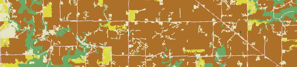
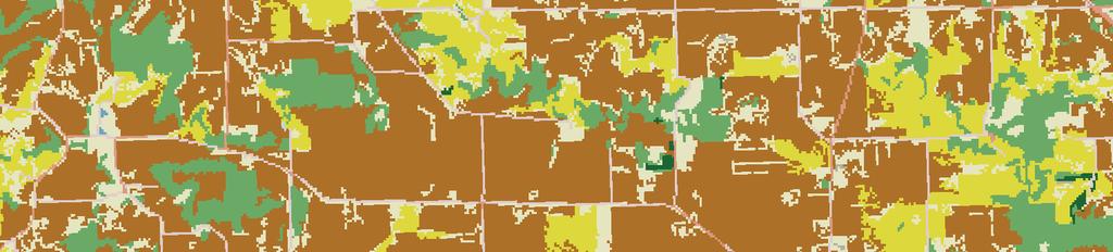
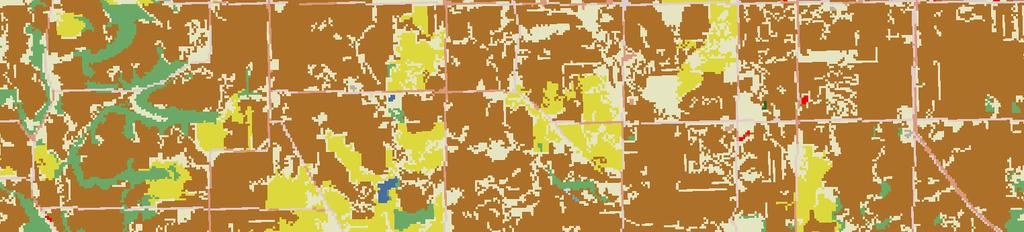
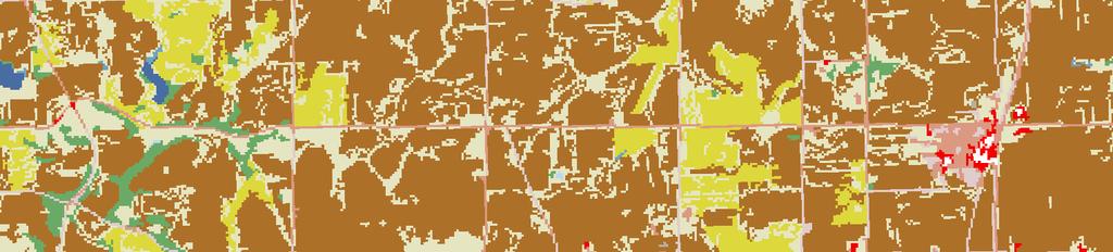
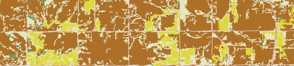
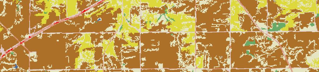
12 Map Document: (P:\007\gis\permit\Final\SPA_Exhibits\007lulc0B_ex.mxd) 0//00 -- :33: AM 00 Westwood Professional Services, Inc. Base National Land Cover Data (000) Open Water (0.%) Low Intensity Residential (.%) High Intensity Residential (.%) Commercial/Industrial/Transportation (<0.0%) Bare Rock/Sand/Clay (<0.0%) Deciduous Forest (3.%) Evergreen Forest (<0.0%) Grassland/Herbaceous (.%) Pasture/Hay (.3%) Row Crops (60.3%) Woody Wetlands (<0.0%) Emergent Herbaceous Wetlands (<0.0%) Twp. Data Source(s): USGS National Land Cover Database (000), Westwood (00). 0,00 Land Cover Map EXHIBIT A-


: MnDOT Basemap (00),")
13 County Rd 0 County Rd County Rd 7 Zu Map Document: (P:\007\gis\permit\Final\SPA_Exhibits\007topo0B_ex.mxd) 0//00 -- :: AM 00 Westwood Professional Services, Inc. Elevation Base G 0 ft Contour High and Low Points High :,3 ft Section Boundary Mid :,06 ft Low : ft 3th St. Belle Creek County Hwy Hay Creek G Ft 30th St. 3 St. State Hwy st Ave County Hwy County Hwy G 3 Ft 30th St. Go 00th St. Twp. 0th St. US Hwy State Hwy 0th St. County Hwy Data Source(s): MnDOT Basemap (00), USGS /3 Arc Second DEM (00), USGS NHD (00), ESRI Political Boundaries (006), Westwood (00). 0,00 Digital Elevation Map EXHIBIT A-
14 County Rd 0 County Rd 7 County Rd Map Document: (P:\007\gis\permit\Final\SPA_Exhibits\007crm0B_ex3.mxd) 0//00 -- :3:7 PM 00 Westwood Professional Services, Inc. s of Possible Cultural Significance with Previously Identified Archaeological Sites Previously Identified Historic Structure Abandoned/Unincorporated Unidentified Linear Feature Abandoned Railroad Grade (Currently a Snowmobile Trail Within ) Historic Base Section Boundary 3th St. 3 County Hwy Belle Creek White Rock County Hwy 0 3 St. 3 0 Ryan 3 3 Black Oak st Ave 30th St. County Hwy St.Paul to Dubuque Claybank State Hwy 30th St. Go Zu US Hwy th St. White Willow 6 0th St. 7 Twp. State Hwy 0th St. 3 Data Source(s): MN Board of Water and Soil Resources (006), MN SHPO (00), Andreas, A.T. (An illustraed historical atlas of the state of Minnesota, 7), Anfinson, Scott (Archaeological Regions in Minnesota and the Woodland Period, 0), Trygg, J.W (Composite Maps of the US Land Surveyor's Original Plats and Field Notes, ), Office of the State Archaeologist (00), Land Management Information Center (00), Westwood (00). 0,00 County Hwy Cultural and Archaeological Resources Map EXHIBIT A-3
MINNESOTA OFFICE OF THE STATE AUDITOR JUDITH H. DUTCHER RANKING OF COUNTY EXPENDITURES FOR THE YEAR ENDED DECEMBER 31, 1996
 MINNESOTA OFFICE OF THE STATE AUDITOR RANKING OF COUNTY EXPENDITURES FOR THE YEAR ENDED DECEMBER 31, 1996 JUDITH H. DUTCHER STATE AUDITOR Ranking of County Expenditures October 27, 1998 Government Information
Information for File # RMM
 Information for File # 3-4-RMM Applicant:, L.P. Corps Contact: Ryan Malterud Address: 8 Fifth Street East, St. Paul, Minnesota 56 E-Mail: Ryan.M.Malterud@usace.army.mil Phone: (65) 9-586 Primary County:
Appendix G. Avian and Bat Work Plans
 Appendix G Avian and Bat Work Plans North Ridge Wind Project Avian Survey Work Plan St. Lawrence County, New York Prepared for: Iberdrola Renewables, LLC Two Radnor Corporate Center Suite 200 100 Matsonford
Site Plan/Building Permit Review
 Part 6 Site Plan/Building Permit Review 1.6.01 When Site Plan Review Applies 1.6.02 Optional Pre- Application Site Plan/Building Permit Review (hereafter referred to as Site Plan Review) shall be required
CLASSIFICATION OF HISTORIC LAKES AND WETLANDS
 CLASSIFICATION OF HISTORIC LAKES AND WETLANDS Golden Valley, Minnesota Image Analysis Heather Hegi & Kerry Ritterbusch 12/13/2010 Bassett Creek and Theodore Wirth Golf Course, 1947 FR 5262 Remote Sensing
SUMMIT COUNTY PLANNING AND ENGINEERING DEPARTMENT
 SUMMIT COUNTY PLANNING AND ENGINEERING DEPARTMENT SINGLE-FAMILY SITE PLAN INFORMATION PACKET GENERAL INFORMATION This information packet explains how your application for a single-family site plan will
Chapter Four AIRPORT LAYOUT PLAN SET COMPONENTS
 The purpose of this chapter is to present the graphic representation of the items addressed and recommended in Chapter Three Demand Capacity Analysis and Facility Requirements (page 3-1). The Airport Layout
Conceptual, Preliminary and Final Site Plan Review in Holladay City
 Conceptual, Preliminary and Final Site Plan Review in Holladay City The City of Holladay incorporated in December, 1999 and adopted its own zoning ordinance in May, 2000. All land use decisions are made
Pesi 593 April 17, Variance MVP-ATWS-SM-031 Detailed Habitat Assessment and Portal Searches
 Pesi 593 April 17, 2018 Ms. Tiernan Lennon and Mr. John Schmidt U.S. Fish & Wildlife Service West Virginia Field Office 90 Vance Drive Elkins, WV 26241 RE: Variance MVP-ATWS-SM-031 Detailed Habitat Assessment
Update on Northern Long-eared Bat in Minnesota
 Update on Northern Long-eared Bat in Minnesota For Minnesota Forest Resources Partnership April 7, 2016 By Rich Baker Endangered Species Coordinator MNDNR Ecological and Water Resources Outline: Update
This page is intentionally left blank
 This page is intentionally left blank This page is intentionally left blank MnDOT Metro District Fact Sheet Mpls./St. Paul District Offices: Roseville-Water's Edge (HQ), Golden Valley, Oakdale mndot.gov/metro/
2010 Project Abstract For the Period Ending June 30, 2012
 2010 Project Abstract For the Period Ending June 30, 2012 PROJECT TITLE: The Minnesota Breeding Bird Atlas PROJECT MANAGER: Mark Martell AFFILIATION: Audubon Minnesota MAILING ADDRESS: 2357 Ventura Dr.,
DRAFT Mad River Wind Project Avian and Bat Survey Work Plan:
 DRAFT Mad River Wind Project Avian and Bat Survey Work Plan: 2016-2017 Jefferson and Oswego Counties, New York Prepared for: Avangrid Renewables, LLC Two Radnor Corporate Center Suite 200 100 Matsonford
TABLE OF CONTENTS 1200 PLAN PREPARATION
 1200 PLAN PREPARATION TABLE OF CONTENTS PAGE 1201 General Plan Sheet Information... 12-1 1201.1 Introduction... 12-1 1201.2 Unit of Measure... 12-1 1201.3 Plan Sheet Materials and File Format... 12-1 1201.4
Tiered Species Habitats (Terrestrial and Aquatic)
") Tiered Species Habitats (Terrestrial and Aquatic) Dataset Description Free-Bridge Area Map The Department of Game and Inland Fisheries (DGIF s) Tiered Species Habitat data shows the number of Tier 1, 2
Tiered Species Habitats (Terrestrial and Aquatic) Dataset Description Free-Bridge Area Map The Department of Game and Inland Fisheries (DGIF s) Tiered Species Habitat data shows the number of Tier 1, 2
WISCONSIN BIRD CONSERVATION INITIATIVE IMPORTANT BIRD AREAS PROGRAM
 WISCONSIN BIRD CONSERVATION INITIATIVE IMPORTANT BIRD AREAS PROGRAM NOMINATION FORM The Wisconsin Bird Conservation Initiative (WBCI) is conducting an inventory of areas that may qualify as Important Bird
Corps No. NWP Page 1 of 9
 DR ALOCLEK AMBERWOOD DR AMBERBROOK DR NW CORNELL RD 194TH AVE 26 Hillsboro 30 84 THORNCROFT DR Portland 5 STUCKI AVE 205 Newberg ROCKSPRING LN 210TH LN SWIRE LN AMBER VIEW LN HODES DR 206TH AVE AMBERGLEN
Photographs, Prints and Postcards. Historic County Courthouses. Minnesota. Part One
 Photographs, Prints and Postcards of Historic County Courthouses in Minnesota Part One Grant County Courthouse (2012). Elbow Lake, Minnesota. Building constructed in 1906. Source: Gobonobo, photographer
Bird and Bat Conservation Strategy EcoHarmony West Wind Energy Project Fillmore County, Minnesota
 Bird and Bat Conservation Strategy EcoHarmony West Wind Energy Project Fillmore County, Minnesota November 2012 Prepared for: Gamesa Energy USA LLC Attn: Bill Smeaton 3001 Broadway Street NE, Suite 695
Appendix B. Airport Master Plan Update William R. Fairchild International Airport Port Angeles, Washington AIRPORT LAYOUT PLAN CHECKLIST
 APPENDICES Appendix B AIRPORT LAYOUT PLAN CHECKLIST 3 Airport Master Plan Update William R. Fairchild International Airport Port Angeles, Washington September 2011 AC 150/5070-6B (incl. Chg. 1, 5/1/07)
Appendix N. Haile Gold Mine EIS Supporting Information and Analysis for Visual Resources Assessment
 Appendix N Supporting Information and Analysis for Visual Resources Assessment This page is left blank intentionally. Table of Contents Page N. Methodology for Identification of Key Observation Points
Catalog of Upper Mississippi River and Great Lakes Region Joint Venture GIS Data March 2009 Version 1
 Catalog of Upper Mississippi River and Great Lakes Region Joint Venture GIS Data March 2009 Version 1 Compiled by: Bradly Potter Introduction This catalog contains descriptions of GIS data available from
PLANNING DEPARTMENT SUBMITTAL REQUIREMENTS FOR CONDITIONAL USE PERMITS CLASS 4 DEVELOPMENT REVIEW PROCESS. A. Written Material
 PLANNING DEPARTMENT 970.668.4200 0037 Peak One Dr. PO Box 5660 www.summitcountyco.gov Frisco, CO 80443 SUBMITTAL REQUIREMENTS FOR CONDITIONAL USE PERMITS CLASS 4 DEVELOPMENT REVIEW PROCESS Per the provisions
STATE OF KANSAS DEPARTMENT OF TRANSPORTATION PLAN AND PROFILE OF PROPOSED STATE HIGHWAY FEDERAL AID PROJECT 1 PAWNEE COUNTY US-56
 OF INDEX OF 1 7 FOUNDATION TREATMENT, COMPACTION & SUBGRADING DETAIL 8 SALVAGED TOPSOIL 15 SIDEROAD PLAN-PROFILE 16 RIGHT OF WAY MONUMENT INSTALLATION DETAIL SHEET -23 PAVING DETAILS 24-29 PAVEMENT DETAILS
Radio Frequency Engineering Report. Proposed Raymond, ME Cellular Facility
 Radio Frequency Engineering Report Proposed, ME Cellular Facility (Site No.: 3462 ) May 12, 2010 C Squared Systems, LLC 920 Candia Road Manchester, NH 03109 Phone: (603) 657-9702 Fax: (603) 657-9707 Support@csquaredsystems.com
B.2 MAJOR SUBDIVISION PRELIMINARY PLAN CHECKLIST
 B.2 MAJOR SUBDIVISION PRELIMINARY PLAN CHECKLIST YES* GENERAL SUBMISSION ITEMS Does the submission include: 1. Thirteen (13) copies of completed Application Form? 2. Thirteen (13) copies of the Preliminary
Photographs, Prints and Postcards. Historic County Courthouses. Minnesota. Part One
 Photographs, Prints and Postcards of Historic County Courthouses in Minnesota Part One Grant County Courthouse (2012). Elbow Lake, Minnesota. Building constructed in 1906. It is on the National Register
Natural Resource Inventory/Forest Stand Delineation(NRI/FSD) and Forest Conservation Plan Exemption
 and Forest Conservation Plan Exemption") MONTGOMERY COUNTY PLANNING DEPARTMENT THE MARYLAND-NATIONAL CAPITAL PARK AND PLANNING COMMISSION Natural Resource Inventory/Forest Stand Delineation(NRI/FSD) and Forest Conservation Plan Exemption Application
MONTGOMERY COUNTY PLANNING DEPARTMENT THE MARYLAND-NATIONAL CAPITAL PARK AND PLANNING COMMISSION Natural Resource Inventory/Forest Stand Delineation(NRI/FSD) and Forest Conservation Plan Exemption Application
Minor Site Plan Application and Checklist Land Disturbing Activities
 Minor Site Plan Application and Checklist Land Disturbing Activities INSTRUCTIONS: Please provide the requested information below. The Development Services Department reviews each site plan submittal based
Red-breasted Merganser Minnesota Conservation Summary
 Credit Jim Williams Red-breasted Merganser Minnesota Conservation Summary Audubon Minnesota Spring 2014 The Blueprint for Minnesota Bird Conservation is a project of Audubon Minnesota written by Lee A.
Sharp-tailed Grouse Minnesota Conservation Summary
 Credit Jim Williams Sharp-tailed Grouse Minnesota Conservation Summary Audubon Minnesota Spring 2014 The Blueprint for Minnesota Bird Conservation is a project of Audubon Minnesota written by Lee A. Pfannmuller
CONCEPT REVIEW GUIDELINES
 Department of Planning & Community Development @ Jefferson Station 1526 E. Forrest Avenue Suite 100 East Point, GA 30344 404.270.7212 (Phone) 404.765.2784 (Fax) www.eastpointcity.org CONCEPT REVIEW GUIDELINES
applications, tips, and tricks for landowners that make mapping easy July 10, 2013
 Mapping My Land: applications, tips, and tricks for landowners that make mapping easy Topic 2 of 4: The whats and whys of good mapping James Jeuck -Extension Associate, NCSU Extension Forestry -Vice President,
Central Platte Natural Resources District-Remote Sensing/Satellite Evapotranspiration Project. Progress Report September 2009 TABLE OF CONTENTS
 Central Platte Natural Resources District-Remote Sensing/Satellite Evapotranspiration Project Progress Report September 2009 Ayse Irmak, Ph.D. Assistant Professor School of Natural Resources, Department
To: EverPower From: Stantec Consulting Services Inc. NYSDEC. 30 Park Drive Topsham, ME File: Date: February 11, 2014
 Memo To: From: Stantec Consulting Services Inc. NYSDEC 30 Park Drive Topsham, ME File: 195600883 Date: February 11, 2014 Reference: Cassadaga Wind Project Habitat Assessment INTRODUCTION Following the
Work Plan for Pre-Construction Avian and Bat Surveys
 Work Plan for Pre-Construction Avian and Bat Surveys, Steuben County, New York Prepared For: EverPower Wind Holdings, Inc. 1251 Waterfront Place, 3rd Floor Pittsburgh, PA 15222 Prepared By: Stantec Consulting
City of Colleyville Community Development Department. Site/Landscape Plan Application Packet
 City of Colleyville Community Development Department Site/Landscape Plan Application Packet 1 Development Application Fees City of Colleyville 100 Main Street Colleyville TX 76034 817.503.1050 Zoning Zoning
911 Telephone Outage Emergency (TOE)
") 911 Telephone Outage Emergency (TOE) An emergency message that defines a local or state 9-1-1 telephone network outage by geographic area or telephone exchange. Authorized officials should provide alternative
911 Telephone Outage Emergency (TOE) An emergency message that defines a local or state 9-1-1 telephone network outage by geographic area or telephone exchange. Authorized officials should provide alternative
Indiana BCR 24 Assessment Summary
 State by BCR Assessment Indiana BCR 24 Assessment Summary Bird conservation Joint Ventures (JVs) were established to help achieve continental bird population goals by designing and managing landscapes
THE Barnard Dunkelberg JACKSON COUNTY. Airport Authority. Inventory of Existing AConditions
 A THE Barnard Dunkelberg Company TEAM JACKSON COUNTY Airport Authority Inventory of Existing AConditions THE Barnard Dunkelberg Company TEAM Lost Creek Lake 227 62 5 Shady Cove 62 Butte Falls 99 Merlin
MARQUETTE GREENWAY TRAIL
 ------ ------ TRAFFIC DATA A.A.D.T. (2010) A.A.D.T. (ED 2022) D.H.V. (2022) DIRECTIONAL DISTRIBUTION TRUCKS N/A N/A N/A N/A N/A DESIGN DATA DESIGN SPEED DESIGN CRITERIA FUNCTIONAL CLASSIFICATION RURAL/URBAN
GIS Data for the Pennsylvania Highlands Alphabetical
 GIS Data for the Pennsylvania Highlands Alphabetical This document contains a compilation of available spatial data for the region, including Geographic Information Systems (GIS) raster and vector data,
Pesi 593 April 17, 2018
 Pesi 593 April 17, 2018 Ms. Tiernan Lennon and Mr. John Schmidt U.S. Fish & Wildlife Service West Virginia Field Office 90 Vance Drive Elkins, WV 26241 RE: Variances MVP-ATWS-SM-027, MVP-ATWS-SM-037, MVP-ATWS-SM-037-
Maintenance of Traffic sequence of operations including any phasing and detour maps;
 All Local-let projects are required to have a Stage 2 submittal to the LPA Manager for review. The only exceptions are 2-lane resurfacing, striping, guardrail, and raised pavement markers, unless otherwise
3 rd Generation Thunderstorm Map. Predicted Duck Pair Accessibility to Upland Nesting Habitat in the Prairie Pothole Region of Minnesota and Iowa
 3 rd Generation Thunderstorm Map Predicted Duck Pair Accessibility to Upland Nesting Habitat in the Prairie Pothole Region of Minnesota and Iowa Grassland Bird Conservation Areas Wetland Reserve Program
Natural Resource Library
 Natural Resource Library UW-Extension Black-Buffalo-Trempealeau Watershed Basin Education Initiative Resources for Teachers and Leaders The Natural Resource Library is Courtesy of: UW-Extension Basin Education
4-H Conservation Guidelines
 4-H Conservation Guidelines The following are guidelines for providing learning experiences in the conservation project area. THE GUIDELINES FOR ALL MEMBERS Understand what Natural Resources are; how to
CHECKLIST PRELIMINARY SUBDIVISION AND PRELIMINARY SITE PLAN
 N/A Waiver (1) Four (4) copies of application form. (2) Fifteen (15) copies of plan (3) Subdivision/site plan application fee & professional review escrow deposit (4) Variance application fee & professional
Ecological Restoration Drafting & Design Guidelines
 Ecological Restoration Drafting & Design Guidelines Version 2.0 July 2017 Philadelphia Water Ecological Restoration Drafting & Design Guidelines Table of Contents 1.0 INTRODUCTION...2 2.0 GENERAL PLAN
MSB 2011 LiDAR & Imagery Project - File Management Schema
 MSB 2011 LiDAR & Imagery Project - File Management Schema The Matanuska-Susitna Borough 2011 LiDAR & Imagery project produced a large number of datasets that are typically made available via portable hard
2017 Annual Volunteer Report
 2017 Annual Volunteer Report Volunteer Statistics Summary 23,164 DNR 280,419 Hours Donated 135 FTE s (Full Time Equivalents based on a 40-hour work week or 2,080 hours/year.) Volunteer hours are equivalent
Deer River Wind Farm 16-F-0267 APPENDIX G
 Deer River Wind Farm 16-F-0267 APPENDIX G Deer River Wind Project Avian Survey Work Plan Lewis County, New York Prepared for: Iberdrola Renewables, LLC Two Radnor Corporate Center Suite 200 100 Matsonford
Appendix B: Noise Study
 Appendix B: Noise Study creating remarkable solutions for a higher quality of life NOISE STUDY Interstate 55 Route PP to County Road 311 Prepared for: MoDOT PROJECT NO. J010956 November 2014 Prepared
Town of Apex, North Carolina
 POND DRAINAGE PLAN APPLICATION Town of Apex, North Carolina POND DRAINAGE PLAN APPLICATION: Applications are due by 12:00 pm on the first business day of each month. Please see the Minor Site Plan Schedule
OAH No , MPUC Dkt No. IP6701/WS STATE OF MINNESOTA OFFICE OF ADMINISTRATIVE HEARINGS
 OAH No. -00--, MPUC Dkt No. IP0/WS-0- STATE OF MINNESOTA OFFICE OF ADMINISTRATIVE HEARINGS FOR THE MINNESOTA PUBLIC UTILITIES COMMISSION IN THE MATTER OF THE APPLICATION BY AWA GOODHUE WIND, LLC FOR A
WELCOME. Open House. meeting is downstairs in the Foot Room RED WING BRIDGE PROJECT. US 63 River Bridge and Approach Roadways.
 WELCOME RED WING BRIDGE PROJECT US 63 River Bridge and Approach Roadways Open House meeting is downstairs in the Foot Room November 2016 Plum/3rd Street Traffic Control Change Signal to All-Way Stop Plum
Photographs, Prints and Postcards. Historic County Courthouses. Minnesota. Part Two
 Photographs, Prints and Postcards of Historic County Courthouses in Minnesota Part Two McLeod County Court House Glencoe, Minnesota Date photograph taken: 1909 Source: LakesnWoods.com McLeod County Court
Northern Pass. Transmission Project: Visual Simulations. The THE NORTHERN PASS SM. MAY 2011_v2
 The Northern Pass Transmission Project: Visual Simulations THE NORTHERN PASS SM Northern Pass PO Box 330 780 North Commercial Street Manchester, NH 03105-0330 800-286-7305 www.northernpass.us MAY 2011_v2
Currently Future Agency Used for Use for Classification Property
 Page 1 This document is made available electronically by the Minnesota Legislative Reference Library as part of an ongoing digital archiving project. http://www.leg.state.mn.us/lrl/lrl.asp Records for
2011 Mn/DOT Greater Minnesota Construction Projects Source: Minnesota Department of Transportation
 2011 Mn/DOT Greater Minnesota Construction Projects Source: Minnesota Department of Transportation District 1 Duluth/Virginia 1 Hwy 1 Location: South of Ely in Lake County, 15 miles Dates: July-Nov 2011
Section E NSPS MODEL STANDARDS FOR TOPOGRAPHIC SURVEYS Approved 3/12/02
 Section E NSPS MODEL STANDARDS FOR TOPOGRAPHIC SURVEYS Approved 3/12/02 1. INTRODUCTION This standard is written to provide the professional surveyor (Surveyor) and the client with a guideline for producing
WORLAND COMMUNITY MARKERS
 APPENDIX A MAPS 1. Worland Community Markers 2. 2014 Jurisdictional Boundary 3. Current Land Use Map with Graph 4. Main Street Overlay 5. 2014 Street Functional Classification 6. Trail Master Plan Map
Minnesota BCR 12 Assessment Summary
 State by BCR Assessment Minnesota BCR 12 Assessment Summary Bird conservation Joint Ventures (JVs) were established to help achieve continental bird population goals by designing and managing landscapes
CHAPTER 11 PRELIMINARY SITE PLAN APPROVAL PROCESS
 CHAPTER 11 PRELIMINARY SITE PLAN APPROVAL PROCESS 11.01.00 Preliminary Site Plan Approval 11.01.01 Intent and Purpose 11.01.02 Review 11.01.03 Application 11.01.04 Development Site to be Unified 11.01.05
STATE OF NEW JERSEY BOARD OF PUBLIC UTILITIES
 STATE OF NEW JERSEY BOARD OF PUBLIC UTILITIES : IN THE MATTER OF THE PETITION OF : PUBLIC SERVICE ELECTRIC AND GAS : COMPANY FOR A DETERMINATION : PURSUANT TO THE PROVISIONS OF : N.J.S.A. 0:D-1 : BPU DOCKET
THE HEXAGON/PANEL SYSTEM FOR SELECTING FIA PLOTS
 THE HEXAGON/PANEL SYSTEM FOR SELECTING FIA PLOTS UNDER AN ANNUAL INVENTORY Gary J. Brand, Mark D. Nelson, Daniel G. Wendt, and Kevin K. Nirnerfro AI3SRACT.-Forest Inventory and Analysis (FIA) is changing
WIRELESS TELECOMMUNICATION FACILITIES. Chapter 15
 Title 9 Land Management Code WIRELESS TELECOMMUNICATION FACILITIES Chapter 15 9-15-1: PURPOSE: 9-15-2: DEFINITIONS: 9-15-3: APPLICABILITY: 9-15-4: MASTER PLAN REQUIRED: 9-15-5: ALLOWABLE USES: 9-15-6:
Due Date: September 22
 Geography 309 Lab 1 Page 1 LAB 1: INTRODUCTION TO REMOTE SENSING Due Date: September 22 Objectives To familiarize yourself with: o remote sensing resources on the Internet o some remote sensing sensors
Minor Site Plan Review Process
 Minor Site Plan Review Process Pre-Application Conference Community Meeting (optional) Submit Application Determination of Completeness Staff Report (optional) Technical Review Committee Decision Notice
APPLICATION FOR PLANNED UNIT DEVELOPMENT (PUD) DEVELOPMENT PLAN
 DEVELOPMENT PLAN") 209 S. Main Street Marysville, Ohio 43040 Phone: (937) 645-7350 Fax: (937) 645-7351 www.marysvilleohio.org APPLICATION FOR PLANNED UNIT DEVELOPMENT (PUD) DEVELOPMENT PLAN *** IMPORTANT INFORMATION ~ Please
209 S. Main Street Marysville, Ohio 43040 Phone: (937) 645-7350 Fax: (937) 645-7351 www.marysvilleohio.org APPLICATION FOR PLANNED UNIT DEVELOPMENT (PUD) DEVELOPMENT PLAN *** IMPORTANT INFORMATION ~ Please
Tahkenitch Creek Estuary BCS number: 47-35
 Tahkenitch Creek Estuary BCS number: 47-35 ***NOTE: We were unable to determine all necessary information for this site description. If you would like to contribute the needed information to this description,
CHAPTER 11 SURVEY CADD
 CHAPTER 11 SURVEY CADD Chapter Contents Sec. 11.01 Sec. 11.02 Sec. 11.03 Sec. 11.04 Sec. 11.05 Sec. 11.06 Sec. 11.07 Sec. 11.08 Sec. 11.09 Sec. 11.10 General Description of Survey File Contents of Survey
MSB Imagery Program FAQ v1
 MSB Imagery Program FAQ v1 (F)requently (A)sked (Q)uestions 9/22/2016 This document is intended to answer commonly asked questions related to the MSB Recurring Aerial Imagery Program. Table of Contents
RESIDENTIAL DEMOLITION PERMIT APPLICANT CHECKLIST
 RESIDENTIAL DEMOLITION PERMIT APPLICANT CHECKLIST The purpose of this form is to inform applicants of: 1) the requirements for building permits and stormwater permits for residential demolition projects;
DEVELOPMENT REVIEW COMMENTS LAND DISTURBANCE PERMIT (LDP) CLEARING CLEARING & GRUBBING GRADING. Date Reviewed by. Project Name
 CLEARING CLEARING & GRUBBING GRADING. Date Reviewed by. Project Name") GWINNETT COUNTY Department of Planning and Development One Justice Square 446 West Crogan Street Suite 150 1 st Floor Lawrenceville, GA 30046 Phone: 678.518.6000 Fax: 678.518.6240 www.gwinnettcounty.com
GWINNETT COUNTY Department of Planning and Development One Justice Square 446 West Crogan Street Suite 150 1 st Floor Lawrenceville, GA 30046 Phone: 678.518.6000 Fax: 678.518.6240 www.gwinnettcounty.com
Watching for Whoopers in Wisconsin Wetlands
 Summary Students make maps of their communities to explore whooping crane habitat close to their neighborhoods. Objectives: Students will be able to: Use a variety of geographic representations, such as
Technical Memorandum ECO-7
 To: Woody Frossard, TRWD From: Bob Brashear, CDM This document is released for the purpose of interim review under the authority of Robert Brashear, P.E., TX license 80771 on 21-Mar-2005. It is not to
3.0 AFFECTED ENVIRONMENT
 3.0 AFFECTED ENVIRONMENT 3.1 Visual Resources This section provides a discussion of the existing visual resources in the vicinity of the Imperial Valley Solar Energy Center South project site that could
ABC and Innovative Bridge Construction for Minnesota Local Roads
 ABC and Innovative Bridge Construction for Minnesota Local Roads May 23, 2013 To box the cha of t unl qua gra ma all g You ma add Tex Chris Werner, PE Senior Bridge Engineer HDR Engineering, Inc. 763-278-5918
INTENT An Administrative Site Plan is required for the following situations, excluding single-family detached development:
 SECTION 13-400 ADMINISTRATIVE SITE PLAN 13-401 INTENT An Administrative Site Plan is required for the following situations, excluding single-family detached development: A. All development on vacant land
Greenleigh at Crossroads
 Greenleigh at Crossroads Middle River, MD 21220 2560 LORD BALTIMORE DRIVE BALTIMORE, MD 410.788.0100 SJPI.COM GREENLEIGH AT CROSSROADS ABOUT Baltimore County s New Urbanism About Greenleigh at Crossroads
APPENDIX G WETLAND ASSESSMENT METHODOLOGY
 APPENDIX G WETLAND ASSESSMENT METHODOLOGY Wetland Assessment Methodology Figure G-1: NLX Project Area and Project Site Locations Wetland Assessment Methodology Pre-Field Prepwork An 11 X 17 flip book
Summerland Planning Advisory Committee. SunPAC Meeting #31 April 28, 2011
 Summerland Planning Advisory Committee SunPAC Meeting #31 April 28, 2011 1 SunPAC Meeting Agenda Call to Order Item 1: Pledge of allegiance and roll call Agenda Item: 1 Item 2: Public comment period Item
HAMILTON TOWNSHIP Department of Planning and Zoning Application for a Commercial / Industrial Site Plan Review
 HAMILTON TOWNSHIP Department of Planning and Zoning Application for a Commercial / Industrial Site Plan Review Date: Application is hereby made for a Site Plan Review for a commercial or industrial use.
SACRAMENTO ENVIRONMENTAL COMMISSION
 SACRAMENTO ENVIRONMENTAL COMMISSION Robert Bailey Mark Barry Dana Curran, Vice Chair Dr. Anthony DeRiggi Richard Hunn, Chair Diane Kindermann George Buzz Link Margie Namba Eric Rivero- Montes Mark White
Minnesota Department of Transportation 2011 Greater Minnesota Construction Projects
 Minnesota Department of Transportation 0 Greater Minnesota Construction Projects Warroad 4 Baudette 43 49 54 53 37 Thief River Falls 48 53 47 East Grand Forks 39 Crookston 38 50 3 5 4 46 94 06 0 03 94
12 OF 29. Event Space & Parking. Outdoor Venue. Project # SWF Date: August 24, 2017 SEE SHEET C-116 SEE SHEET C-113
 COTTON GIN ROAD SEE SHEET C-101 SEE SHEET C-102 SEE SHEET C-103 LEGACY ROAD STEWA RT CR SEE SHEET C-104 SEE SHEET C-105 EEK SEE SHEET C-106 Event Space & SEE SHEET C-107 SEE SHEET C-108 SEE SHEET C-109
Title Marsh Bird Habitat Restoration and Management on Private and Public land in Arkansas Mississippi Alluvial Valley
 Title Marsh Bird Habitat Restoration and Management on Private and Public land in Arkansas Mississippi Alluvial Valley Project Summary: Changes in habitat and hydrology have caused serious declines in
Hogg Bird Sanctuary Study Frequently Asked Questions March 2017
 Hogg Bird Sanctuary Study Frequently Asked Questions March 2017 Study and Program Process What was the purpose of this study of Hogg Bird Sanctuary? In support of the Memorial Park Master Plan, the led
ArcGIS Online Content
 Esri International User Conference San Diego, California Technical Workshops July 25, 2012 ArcGIS Online Content Deane Kensok Sarah Osborne Today s Agenda Overview Esri Content Portfolio - What s Available,
COMMUNITY BACKGROUND CHAPTER 1. Page 1 of 16, Chapter 1
 CHAPTER 1 COMMUNITY BACKGROUND Page 1 of 16, Chapter 1 ORDER OF CONTENTS I. PREFACE TO THE COMPREHENSIVE PLAN... 3 II. DEVELOPMENT / HISTORY / TRENDS... 3 A. Early History... 3 B. Recent History... 3 III.
Upcoming Events. Nature Talks December SWCD Annual Tree Sale SWCD Poster Contest SHERBURNE SOIL AND WATER CONSERVATION DISTRICT
 SHERBURNE SOIL AND WATER CONSERVATION DISTRICT Sherburne Soil & Water Conservation District Nature Talks December 2015 SWCD Annual Tree Sale Tree Sale Conservation Award Native Plant Sale Winter Bird Feeding
Land Use Alternatives or Scenarios
 Chapter 6 Land Use Alternatives or Scenarios Included in this chapter: Definition of Land Use Alternatives or Scenarios Purpose of Creating Alternatives Guiding Principles Scenario Building Public Involvement
PUBLIC NOTICE. Permit Application No. SAJ (IP-MJD)
") DEPARTMENT OF THE ARMY JACKSONVILLE DISTRICT CORPS OF ENGINEERS FORT MYERS REGULATORY OFFICE 1520 ROYAL PALM SQUARE BOULEVARD, SUITE 310 FORT MYERS, FLORIDA 33919 Regulatory Division South Permits Branch/West
DEPARTMENT OF THE ARMY JACKSONVILLE DISTRICT CORPS OF ENGINEERS FORT MYERS REGULATORY OFFICE 1520 ROYAL PALM SQUARE BOULEVARD, SUITE 310 FORT MYERS, FLORIDA 33919 Regulatory Division South Permits Branch/West
LOWNDES COUNTY ENGINEERING PLAN REVIEW CHECKLIST. Design Professional: Phone: Developer: Phone: 2 nd Submittal (No Fee)
") MEMORANDUM MICHAEL B. FLETCHER, P.E. COUNTY ENGINEER 327 N. Ashley Street Valdosta, GA 31601 Telephone: (229) 671-2424 Fax: (229) 245-5299 mfletcher@lowndescounty.com LOWNDES COUNTY ENGINEERING PLAN REVIEW
MEMORANDUM MICHAEL B. FLETCHER, P.E. COUNTY ENGINEER 327 N. Ashley Street Valdosta, GA 31601 Telephone: (229) 671-2424 Fax: (229) 245-5299 mfletcher@lowndescounty.com LOWNDES COUNTY ENGINEERING PLAN REVIEW
Western Alberta Transmission Line
 Western Alberta Transmission Line July 010 Who can you contact for more information? To learn more about the proposed project you can contact: AltaLink at 1-877-67-5973 (toll-free) E-mail: westernline@altalink.ca
Threatened & Endangered Species and T&E Habitats Encountered during Road and Bridge Projects
 Threatened & Endangered Species and T&E Habitats Encountered during Road and Bridge Projects Keto Gyekis Wetland Identification Program (WIP) Coordinator T&E Species Technical Review Coordinator Project
Appendix P Contact Information
 Appendix P Contact Information Conservation Districts Capitol Conservation District 418 Goff Mountain Road, Suite 102 Cross Lanes, WV 25313 Phone: (304) 759-0736 Fax: (304) 776-5326 Eastern Panhandle Conservation
Each spring, the Minnesota DNR coordinates statewide ruffed grouse (Bonasa
 2014 MINNESOTA SPRING GROUSE SURVEYS Charlotte Roy Forest Wildlife Populations and Research Group Minnesota Department of Natural Resources Grand Rapids, Minnesota 19 June 2014 SUMMARY OF FINDINGS Each
NR402 GIS Applications in Natural Resources
 NR402 GIS Applications in Natural Resources Lesson 5 GPS/GIS integration Global Positioning System (GPS)..a global navigation system that everyone can use What is GPS? How does it work? How accurate is