Twenty Year Forecasts of Population and Households, Louisville Economic Area
|
|
|
- Theresa Lucas
- 6 years ago
- Views:
Transcription

1 Twenty Year Forecasts of Population and Households, Louisville Economic Area Economic Geography The U.S. Bureau of Economic Analysis (BEA) assigns every county in the nation to an economic area. BEA s economic areas define the relevant regional markets surrounding metropolitan or micropolitan statistical areas. Each economic area consists of one or more economic nodes, which are metropolitan or micropolitan statistical areas that serve as regional centers of economic activity, as well as the surrounding counties that are economically linked to the nodes. The delineations are primarily determined by commuting patterns and newspaper readership data. The Louisville Economic Area is comprised of 25 counties in Kentucky and southern Indiana with Louisville located in the center. The Louisville Economic Area consists of the 12 county Louisville Metropolitan Statistical Area (MSA), the Elizabethtown-Fort Knox MSA, the Bardstown Micropolitan Statistical Area (µsa), the Campbellsville µsa, the Madison µsa in Indiana, and several surrounding rural counties.
2 In order to present data within a county, the U.S. Census Bureau delineates census tracts for every county in the nation. Census tracts are created using identifiable features such as roads, rivers and railroad tracks, and encompass approximately 4,000 people. Census tracts are meant to be relatively homogenous units, representing populations with similar characteristics. Census tracts do not cross county boundaries, and data for all census tracts in a county will sum to that county s total. There are 397 census tracts in the 25 county Louisville Economic area, of which 191 are in Jefferson County. There were 637,000 households in the region in 2010, with a combined population of 1.6 million. Of this regional population, 46 percent reside in Jefferson County. Forecasts of Population and Households We forecasted the number of households and total population for each of the 397 census tracts in the 25 county economic area. This process integrated data from the 2000 and 2010 Census, the 2011 National Land Cover Database, and existing county-level forecasts of population provided by the Indiana and Kentucky State Data Centers. We began by forecasting the population in households for each census tract using the Hamilton-Perry method. This method involves calculations of rates of change for each age group in each census tract between two Census periods and then carrying the rates of change forward into the projection period. Limits on the amount of growth that could occur in a time period were derived from the National Land Cover Database to ensure population density remained reasonable given the zoning of an area. Additional adjustments were made through an expert review process, which gave special consideration to census tracts likely to be affected by pending events including the Ohio River Bridges Project, the loss of jobs at Fort Knox, and continuing patterns of suburbanization. The tract level forecasts were then calibrated against the county level forecasts developed by the state demographers at the University of Louisville and Indiana University to ensure the sum of the tracts equaled the county total. The tract level forecasts of population in households were translated into forecasts of households using the headship method. This method involves calculating the proportion of the population in households that are the head of household from the most recent Census and applying this rate to the forecasts of population in households. Having determined forecasts of the number of households and the population in households for each tract, we then calculated the predicted average household size for each tract. Forecasts of total population were made by adding in the population in group quarters to the forecasts of population in households. The population in group quarters is assumed to remain constant through the projection period.
3 County Level Forecasts Most of the region s population growth is expected to occur in the counties surrounding Jefferson County. While Jefferson County is projected to grow 13 percent over the next few decades, the other 11 counties in the Louisville MSA are projected to grow 29 percent, more than double the rate of Jefferson County. The Louisville MSA, including Jefferson County, is projected to grow nearly 20 percent. The 13 counties outside of the Louisville MSA are projected to grow by 15 percent. The total 25 county area is projected to grow nearly 19 percent. Forecasted Population Growth, Change Percent Change Jefferson County, KY 99, % Louisville MSA 247, % TOTAL - 25 County 301, % The forecasted household size is expected to decline slightly, but remain close to 2010 levels. With stabilized average household size, it is expected that population growth and household growth will occur at similar rates. Forecasted Household Growth, Change Percent Change Jefferson County, KY 42, % Louisville MSA 102, % TOTAL - 25 County 127, % Forecasted Household Size, Census 2010 Census Jefferson County, KY Louisville MSA TOTAL - 25 County
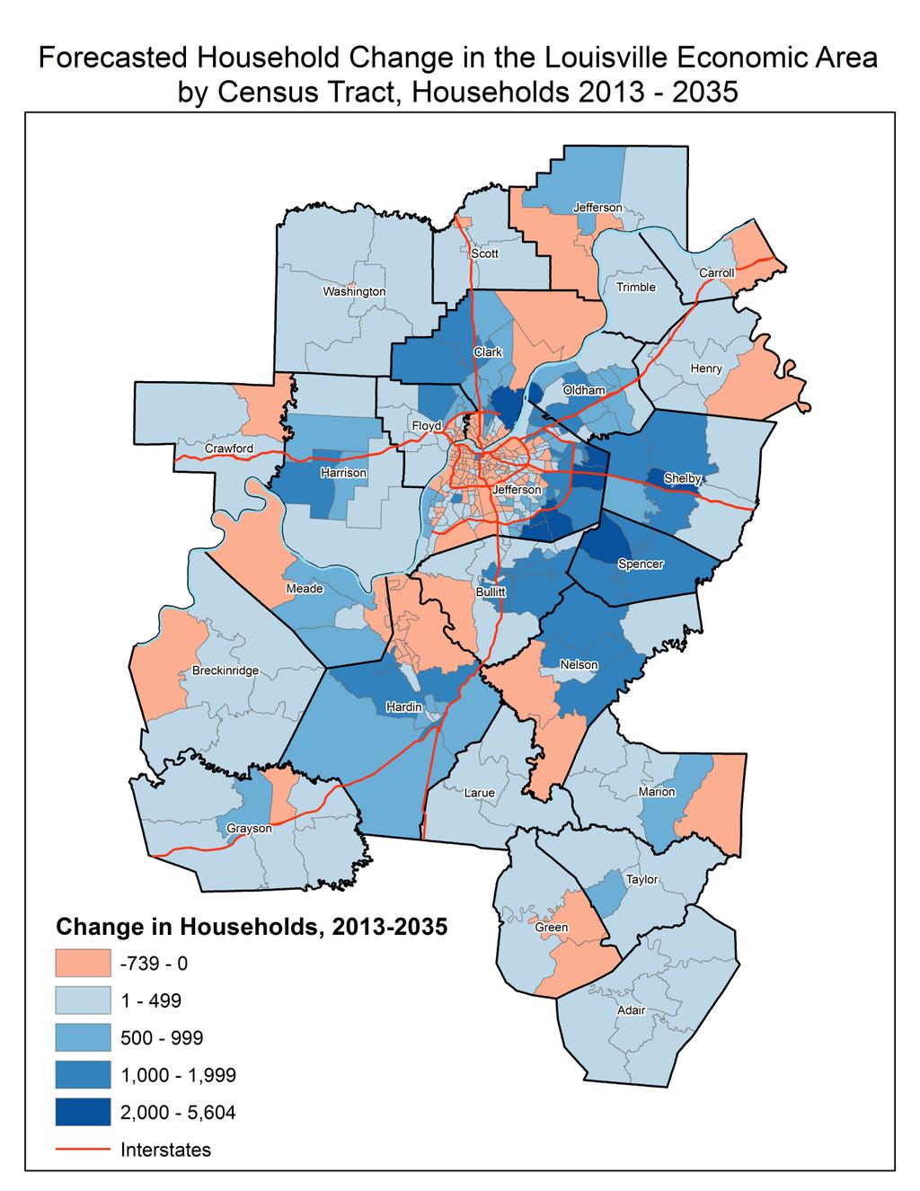
4 Jefferson County is predicted to experience the largest absolute growth in the number of households. The four counties surrounding Jefferson are projected to have the largest percentage increase in the number of households. Bullitt, Oldham, Shelby and Spencer counties are expected to experience at least a 45 percent increase in the number of households by These four counties along with Jefferson account for 65 percent of the expected household growth in the region over the next few decades. Hardin and Nelson counties and Clark County, Indiana are also projected to experience sizeable increases in the number of households over the next twenty years. Forecasted Household Growth, Change Percent Change Clark County, IN 8, % Crawford County, IN % Floyd County, IN 3, % Harrison County, IN 3, % Jefferson County, IN % Scott County, IN 1, % Washington County, IN 1, % Adair County, KY 1, % Breckinridge County, KY 1, % Bullitt County, KY 13, % Carroll County, KY % Grayson County, KY % Green County, KY % Hardin County, KY 8, % Henry County, KY % Jefferson County, KY 42, % Larue County, KY % Marion County, KY 1, % Meade County, KY 1, % Nelson County, KY 6, % Oldham County, KY 11, % Shelby County, KY 8, % Spencer County, KY 6, % Taylor County, KY 1, % Trimble County, KY % TOTAL - 25 County 127, % Census Tract Level Forecast Summary The maps below show the forecasted change in households in both absolute and percentage terms in the 25 county region through As can be seen in the maps, the greatest growth in households will occur in eastern Jefferson County and the tracts to the east and southeast of Jefferson County in Oldham, Shelby, Spencer and Bullitt Counties.
5
6

7 The next map shows the top twenty tracts that are forecasted to experience the largest absolute growth in households. Eight of the top twenty tracts are located in eastern and southeastern Jefferson County near the Gene Snyder Freeway. The tract in Clark County, Indiana near Utica, Charlestown and northeastern Jeffersonville is forecasted to experience sizable household growth in the next few decades due to the accessibility created by the Ohio River Bridges Project. Tracts in the western half of Spencer County near Elk Creek and Taylorsville are projected to gain over 4,000 households by Tracts in western Shelby County near Simpsonville and Shelbyville are projected to grow by nearly 4,000 households. Oldham County is projected to experience considerable household growth near Prospect, River Bluff, and Goshen. Tracts in Bullitt County near Shepherdsville and Mount Washington will continue to gain households over the next twenty years. Only two tracts in the list of top twenty tracts gaining households are in counties not bordering Jefferson County. One is in Nelson County near northern Bardstown which is projected to gain over 1,600 households. The other tract is in Hardin County west of Elizabethtown which is also projected to grow by 1,600 households.

8 The next map shows the bottom twenty tracts forecasted to experience the largest absolute decreases in the number of households. Fourteen of the bottom twenty tracts are located in Jefferson County, most of which are inside the Watterson Expressway. Three tracts are located in southern Indiana near New Albany and Clarksville. Another three tracts are located in Hardin County near Fort Knox and Radcliff. The Fort Knox base is facing sizable job cuts from the U.S. Army, leading to population loss in the area. The region is forecasted to gain population overall in the next twenty years, so the forecasted decreases in households are of a much smaller magnitude than the predicted increases in households. Presentation of Forecasts Three tables are attached that provide detail on the forecasts summarized above. The first presents total population by census tract. The second presents households by census tract. The third presents county populations since the last decennial census and forecasts to 2035.
Office of Transportation Delivery Vickie Bourne, Executive Director KBT January 23, 2015 Medicaid Expansion and Impact on Public Transit
 Office of Transportation Delivery Vickie Bourne, Executive Director KBT January 23, 2015 Medicaid Expansion and Impact on Public Transit Goal for Human Service Transportation Delivery Save Cost/ Cost Containment
US Census. Thomas Talbot February 5, 2013
 US Census Thomas Talbot February 5, 2013 Outline Census Geography TIGER Files Decennial Census - Complete count American Community Survey Yearly Sample Obtaining Data - American Fact Finder - Census FTP
Lowndes County by the Numbers
 Lowndes County by the Numbers How Do We Compare With Peer and Aspirant Communities? 2015 Report This report has been prepared for the Valdosta-Lowndes County Chamber of Commerce by the Center for Business
South Central Indiana Communications Support Group, Inc. The State of Amateur Radio In the State of Indiana
 South Central Indiana Communications Support Group, Inc. The State of Amateur Radio In the State of Indiana September 2011 Since the creation of South Central Indiana Communications Support Group, Inc.
In-Office Address Canvassing for the 2020 Census: an Overview of Operations and Initial Findings
 In-Office Address Canvassing for the 2020 Census: an Overview of Operations and Initial Findings Michael Commons Address and Spatial Analysis Branch Geography Division U.S. Census Bureau In-Office Address
Lowndes County by the Numbers
 Lowndes County by the Numbers How Do We Compare With Peer and Aspirant Communities? 2011 Report DRAFT 05/06/2011 Insert a collage of blended pictures from around Valdosta This report has been prepared
Coordination Guideline. Application of Selective Access
 Coordination Guideline Application of Selective Access 20-Apr-2015 Reduce regional draft document to Illinois specific version Copyright 2015 Illinois Repeater Association Inc. Preface...1 Policy...1 Methodology...2
Claritas Demographic Update Methodology Summary
 Claritas Demographic Update Methodology Summary 2006 by Claritas Inc. All rights reserved. Warning! The enclosed material is the intellectual property of Claritas Inc. (Claritas is a subsidiary of VNU,
Event History Calendar (EHC) Between-Wave Moves File. Codebook
 Between-Wave Moves File. Codebook") 2325 Event History Calendar (EHC) BetweenWave Moves File Codebook Number of Variables 23 Thursday July 2 28 4:5 PM 2325 Event History Calendar (EHC) BetweenWave Moves File EHCV "RELEASE NUMBER" NUM(.)
2325 Event History Calendar (EHC) BetweenWave Moves File Codebook Number of Variables 23 Thursday July 2 28 4:5 PM 2325 Event History Calendar (EHC) BetweenWave Moves File EHCV "RELEASE NUMBER" NUM(.)
Table 5 Population changes in Enfield, CT from 1950 to Population Estimate Total
 This chapter provides an analysis of current and projected populations within the Town of Enfield, Connecticut. A review of current population trends is invaluable to understanding how the community is
Away Game Directions
 Away Game Directions Adena (Scott County Fields) Take the US-62 Georgetown exit off of I-64. Turn left (north) off the exit ramp and continue on US-62 for approximately 1.2 miles. Turn right onto Iron
Employer Location file. Codebook
 232 Employer Location file Codebook Number of Variables 2 Wednesday July 8 28 :9 PM 232 Employer Location file EMPV "RELEASE NUMBER" NUM(.) Release number Release : 7/28, SAS proc geocode and proc ginside
GINI INDEX OF INCOME INEQUALITY Universe: Households American Community Survey 5-Year Estimates
 B19083 GINI INDEX OF INCOME INEQUALITY Universe: Households 2011-2015 American Community Survey 5-Year Estimates Supporting documentation on code lists, subject definitions, data accuracy, and statistical
Geographic Terms. Manifold Data Mining Inc. January 2016
 Geographic Terms Manifold Data Mining Inc. January 2016 The following geographic terms are adapted from the standard definition of Census geography from Statistics Canada. Block-face A block-face is one
Acquiring and Using New Census Data to Understand Service Area, Gaps, and Need
 Acquiring and Using New Census Data to Understand Service Area, Gaps, and Need Agenda What types of Census data are available? Decennial, ACS, other we want mention today. Getting Census Data From American
: Geocode File - Census Tract, Block-Group and Block. Codebook
 196815: Geocode File Census Tract, BlockGroup and Block Codebook Number of Variables 15 Friday June 17 8:49 AM 196815: Geocode File Census Tract, BlockGroup and Block RLS1 "RELEASE NUMBER" NUM(1.) Release
Prince William County
 Prince William County Quarterly Population Estimate Methods October 2016 Department of Information Technology Geographic Information Systems (GIS) Division WHY THE ESTIMATE IS HIGHER From Quarter 3 in
This document explains differences between the March 2008 LSA circuit breaker model and the January 2009 model.
 LEGISLATIVE SERVICES AGENCY Office of Fiscal and Management Analysis 200 W. Washington Street, Suite 302 Indianapolis, Indiana 46204-2789 (317) 233-0696 (317) 232-2554 (FAX) Circuit Breaker Model Update
Poverty in the United Way Service Area
 Poverty in the United Way Service Area Year 2 Update 2012 The Institute for Urban Policy Research At The University of Texas at Dallas Poverty in the United Way Service Area Year 2 Update 2012 Introduction
Fairfax County: Five Major Forces Shaping Its Economic Evolution
 Fairfax County: Five Major Forces Shaping Its Economic Evolution Stephen S. Fuller, Ph.D. The Dwight Schar Faculty Chair and University Professor Director, The Stephen S. Fuller Institute Schar School
ERIE LORAIN HURON ASHLAND WAYNE RICHLAND MORROW KNOX. Columbus East /Newark DELAWARE. Columbus West LICKING FRANKLIN FAIRFIELD PERRY PICKAWAY HOCKING
 Instructions: Choose a territory to find your nearest Energy Advisor in the AEP Ohio Business Incentives Program. Reducing your business's energy use and boosting your bottom line starts here. LUCAS LAKE
Experiences with the Use of Addressed Based Sampling in In-Person National Household Surveys
 Experiences with the Use of Addressed Based Sampling in In-Person National Household Surveys Jennifer Kali, Richard Sigman, Weijia Ren, Michael Jones Westat, 1600 Research Blvd, Rockville, MD 20850 Abstract
ERIE LORAIN HURON ASHLAND WAYNE RICHLAND MORROW KNOX. Columbus East /Newark DELAWARE. Columbus West LICKING FRANKLIN FAIRFIELD PERRY PICKAWAY HOCKING
 Instructions: Choose a territory to find your nearest Energy Advisor in the AEP Ohio Business Incentives Program. Reducing your business's energy use and boosting your bottom line starts here. LUCAS LAKE
Population A Review of Census Data Related to the Population of Allen County, Indiana
 A Demographic and Socio Economic Profile of Allen County, Indiana based on the 2010 Census and the American Community Survey Population A Review of Census Data Related to the Population of Allen County,
An Overview of the American Community Survey
 An Overview of the American Community Survey Scott Boggess U.S. Census Bureau 2009 National Conference for Adult Education State Directors Washington, DC March 17, 2009 1 Overview What is the American
1 NOTE: This paper reports the results of research and analysis
 Race and Hispanic Origin Data: A Comparison of Results From the Census 2000 Supplementary Survey and Census 2000 Claudette E. Bennett and Deborah H. Griffin, U. S. Census Bureau Claudette E. Bennett, U.S.
An Introduction to ACS Statistical Methods and Lessons Learned
 An Introduction to ACS Statistical Methods and Lessons Learned Alfredo Navarro US Census Bureau Measuring People in Place Boulder, Colorado October 5, 2012 Outline Motivation Early Decisions Statistical
Demographics for Program Planning at YMCA Facilities: An Analysis of Selected 1980 Census Data
 University of Nebraska at Omaha DigitalCommons@UNO Publications Archives, 1963-2000 Center for Public Affairs Research Summer 1982 Demographics for Program Planning at YMCA Facilities: An Analysis of Selected
GRAPH P-1: YEARS OF LIFE EXPECTANCY AT BIRTH, FLORIDA AND UNITED STATES, CENSUS YEARS AND YEAR
 Population CHART P-1: YEARS OF LIFE EXPECTANCY AT BIRTH, BY RACE, ETHNICITY, AND GENDER, FOR FLORIDA RESIDENTS AND UNITED STATES, CENSUS YEARS 1970-2000 AND 2004-2014 FLORIDA UNITED STATES 1 1 2 WHITE
2014 County and Economic Development Regions Population Estimates
 214 County and Economic Development Regions Population Estimates Analysis of the US Census Bureau Vintage 214 Total County Population Estimates Jan K. Vink Program on Applied Demographics Cornell University
How Will the Changing U.S. Census Affect Decision-Making?
 How Will the Changing U.S. Census Affect Decision-Making? David A. Swanson University of California Riverside David.swanson@ucr.edu Prepared for the Lewis Seminar May 15, 2008 ACKNOWLEDGMENTS In addition
2012 AMERICAN COMMUNITY SURVEY RESEARCH AND EVALUATION REPORT MEMORANDUM SERIES #ACS12-RER-03
 February 3, 2012 2012 AMERICAN COMMUNITY SURVEY RESEARCH AND EVALUATION REPORT MEMORANDUM SERIES #ACS12-RER-03 DSSD 2012 American Community Survey Research Memorandum Series ACS12-R-01 MEMORANDUM FOR From:
MDwise Excel Network and MDwise Connect Provider Relations Territory Map
 Excel Network and Connect Territory Map 1 Paulette Means pmeans@mdwise.org 317-822-7490 2 Garrett Walker gwalker@mdwise.org 317-983-6088 3 Charmaine Campbell ccampbell@mdwise.org 317-822-7301 4 Jamaal
1980 Census 1. 1, 2, 3, 4 indicate different levels of racial/ethnic detail in the tables, and provide different tables.
 1980 Census 1 1. 1980 STF files (STF stands for Summary Tape File from the days of tapes) See the following WWW site for more information: http://www.icpsr.umich.edu/cgi/subject.prl?path=icpsr&query=ia1c
2020 Census Geographic Partnership Programs. Update. Atlanta Regional Office Managing Census Operations in: AL, FL, GA, LA, MS, NC, SC
 2020 Census Geographic Partnership Programs Atlanta Regional Office Managing Census Operations in: AL, FL, GA, LA, MS, NC, SC Update Alabama State Data Center Conference Agenda 2020 Census Overview 2020
COUNTY-LEVEL DATA ON TENNESSEE S 2018 OBAMACARE ENROLLMENT
 APRIL 19, COUNTY-LEVEL DATA ON TENNESSEE S OBAMACARE ENROLLMENT Last week, we dug into statewide data on open enrollment in private health insurance through the healthcare.gov Marketplace created by the
Overview of Census Bureau Geographic Areas and Concepts
 Overview of Census Bureau Geographic Areas and Concepts Drew Stanislaw US Census Bureau WVAGP Annual Meeting Shepherdstown, WV June 13, 2011 1 What is the role of geography in the Census? The Census count
National Longitudinal Study of Adolescent Health. Public Use Contextual Database. Waves I and II. John O.G. Billy Audra T. Wenzlow William R.
 National Longitudinal Study of Adolescent Health Public Use Contextual Database Waves I and II John O.G. Billy Audra T. Wenzlow William R. Grady Carolina Population Center University of North Carolina
GIS Data Sources. Thomas Talbot
 GIS Data Sources Thomas Talbot Chief, Environmental Health Surveillance Section Bureau of Environmental & Occupational Epidemiology New York State Department of Health Outline Sources of Data Census, health,
Claritas Demographic Update Methodology
 Claritas Demographic Update Methodology 2006 by Claritas Inc. All rights reserved. Warning! The enclosed material is the intellectual property of Claritas Inc. (Claritas is a subsidiary of VNU, a global
The 2010 Census: Count Question Resolution Program
 The 2010 Census: Count Question Resolution Program Jennifer D. Williams Specialist in American National Government December 7, 2012 CRS Report for Congress Prepared for Members and Committees of Congress
Understanding and Using the U.S. Census Bureau s American Community Survey
 Understanding and Using the US Census Bureau s American Community Survey The American Community Survey (ACS) is a nationwide continuous survey that is designed to provide communities with reliable and
City of Richmond 2000 Census Data Report # Household Change by Census Tract
 City of Richmond 2000 Census Data Report #6 1990-2000 Household Change by Census Tract Prepared by Department of Community Development Division of Comprehensive Planning January 2002 Introduction The City
Census Data for Transportation Planning
 Census Data for Transportation Planning Transitioning to the American Community Survey May 11, 2005 Irvine, CA 1 Design Origins and Early Proposals Concept of rolling sample design Mid-decade census Proposed
Produced by the BPDA Research Division:
 Produced by the BPDA Research Division: Alvaro Lima Director Jonathan Lee Deputy Director Christina Kim Research Manager Phillip Granberry Senior Researcher/Demographer Matthew Resseger Senior Researcher/Economist
Working with United States Census Data. K. Mitchell, 7/23/2016 (no affiliation with U.S. Census Bureau)
") Working with United States Census Data K. Mitchell, 7/23/2016 (no affiliation with U.S. Census Bureau) Outline Types of Data Available Census Geographies & Timeframes Data Access on Census.gov website
Working with United States Census Data K. Mitchell, 7/23/2016 (no affiliation with U.S. Census Bureau) Outline Types of Data Available Census Geographies & Timeframes Data Access on Census.gov website
2010 Census Data. Get Ready for Changes in Your 2014 AAPs. Ellen Shong & Associates, LLC 9/13/ Past EEO Tabulations
 2010 Census Data Get Ready for Changes in Your 2014 AAPs Ellen Shong & Associates, LLC 9/13/2013 1 Past EEO Tabulations ORC tabulation based on 1970 Census occupational data. Funded by private organization
THE TOP 100 CITIES PRIMED FOR SMART CITY INNOVATION
 THE TOP 100 CITIES PRIMED FOR SMART CITY INNOVATION Identifying U.S. Urban Mobility Leaders for Innovation Opportunities 6 March 2017 Prepared by The Top 100 Cities Primed for Smart City Innovation 1.
Historical Soybean Yields by County The average soybean yields for counties
 File A1-13 March 18 www.extension.iastate.edu/agdm Historical Soybean Yields by County The average soybean yields for counties and areas in Iowa are included in this file. Averages from 8 through 17 are
Who s in Your Neighborhood? Using the American FactFinder. Salma Abadin and Carrie Koss Vallejo Data You Can Use
 Who s in Your Neighborhood? Using the American FactFinder Salma Abadin and Carrie Koss Vallejo Data You Can Use www.datayoucanuse.org Learning Objectives Learn what American FactFinder is and is not Become
Subject: State-Wide Hoosier Healthwise Mandatory Managed Care Organization Transition
 P R O V I D E R B U L L E T I N B T 2 0 0 5 0 6 M A R C H 9, 2 0 0 5 To: All Providers Subject: State-Wide Hoosier Healthwise Mandatory Managed Care Organization Transition Overview The Office of Medicaid
How It Works and What s at Stake for Massachusetts. Wednesday, October 24, :30-10:30 a.m.
 How It Works and What s at Stake for Massachusetts Wednesday, October 24, 2018 8:30-10:30 a.m. The Original 1790 Census 1. Name of the head of the family 2. # of free white males16 y.o.+ 3. # of free
Commercial Investment Portfolio Sale
 Commercial Investment Portfolio Sale Key Highlights >> Three-property portfolio sale in Downtown Columbia, South Carolina >> Four buildings totaling ±37,200 SF >> Family leased & managed for 50+ years
The Impact of the Great Migration on Mortality of African Americans: Evidence from the Deep South
 The Impact of the Great Migration on Mortality of African Americans: Evidence from the Deep South Dan A. Black Seth G. Sanders Evan J. Taylor Lowell J. Taylor Online Appendix A. Selection of States Our
The U.S. Decennial Census A Brief History
 1 The U.S. Decennial Census A Brief History Under the direction of then Secretary of State, Thomas Jefferson, the first U.S. Census began on August 2, 1790, and was to be completed by April 1791 The total
Individual and Family Health Insurance Rates
 Individual and Family Health Insurance Rates New Business Rates Effective January 1, 2018 * *rates subject to change A Division of Health Care Service Corporation, a Mutual Legal Reserve Company, an Independent
Demographic Characteristics and Trends: Implications for Rural Texas
 Demographic Characteristics and Trends: Implications for Rural Texas Texas Farm Bureau AgLead XI FarmLead IV March 19, 2013 Austin, Texas Lloyd Potter Office: (210) 458-6530 Email: Lloyd.Potter@osd.state.tx.us
Learning to Use the ACS for Transportation Planning Report on NCHRP Project 8-48
 Learning to Use the ACS for Transportation Planning Report on NCHRP Project 8-48 presented to TRB Census Data for Transportation Planning Meeting presented by Kevin Tierney Cambridge Systematics, Inc.
2020 Census: A Look at How Data Provides Answers to Questions and How States Work With the Census Bureau to Ensure Quality Data
 2020 Census: A Look at How Data Provides Answers to Questions and How States Work With the Census Bureau to Ensure Quality Data Presentation For National Council of State Legislators Session Census 2020:
Access to Contraceptive Services in Florida
 Access to Contraceptive Services in Florida Introduction This project aims to determine which Florida county has the least access to family planning services through Title X facilities. With data gathered
NET LEASED INVESTMENT OFFERING Applebee s - Springfield, Ohio
 NET LEASED INVESTMENT OFFERING Applebee s - Springfield, Ohio contact Mark Alviano 919.674.3681 malviano@ investment opportunity Trinity Partners is offering for sale Applebee s NNN Investment - Springfield
2018 Indiana VENTURE REPORT
 218 Indiana VENTURE REPORT Content Overview................................ 2 Indiana s Growing Economy................. 3 Indiana s Value for Business................. 3 National Venture Capital Trends..............
Blow Up: Expanding a Complex Random Sample Travel Survey
 10 TRANSPORTATION RESEARCH RECORD 1412 Blow Up: Expanding a Complex Random Sample Travel Survey PETER R. STOPHER AND CHERYL STECHER In April 1991 the Southern California Association of Governments contracted
Taming the Census TIGER:
 Taming the Census TIGER: Download TIGER Files using American FactFinder Eric Coyle Data Dissemination Specialist U.S. Census Bureau Outline ACS Overview Census Geography Accessing TIGER/ACS Data Products
BIRTHS, DEATHS, & MARRIAGES
 Grayson County Births: 1852-59, 1861, & 1901-07 Grayson County Births: 1874-1875 through 1876-1878 BIRTHS, DEATHS, & MARRIAGES Grayson County Marriages: 1852-1907 Marriages: 1873-1895 (preformed by Isaac
Hard-to-Count Overview
 Hard-to-Count Overview After each census, the U. S. Census Bureau reviews response rates. Areas that have low response rates are considered to be hard-to-count. Reasons for low response rates may be language
2006 Census Bulletin #1 Population and Dwelling Counts
 2006 Census Bulletin #1 and Dwelling Counts Regional According to the 2006 Census figures recently released by Statistics Canada, the Greater Vancouver th Regional District's (Vancouver Census Metropolitan
Proceedings of the Annual Meeting of the American Statistical Association, August 5-9, 2001
 Proceedings of the Annual Meeting of the American Statistical Association, August 5-9, 2001 COVERAGE MEASUREMENT RESULTS FROM THE CENSUS 2000 ACCURACY AND COVERAGE EVALUATION SURVEY Dawn E. Haines and
High Poverty Areas in the Central Oklahoma Workforce Development Area
 High Poverty Areas in the Central Oklahoma Workforce Development Area Defining High Poverty Areas in: Canadian County Cleveland County Logan County Okfuskee County Oklahoma County Pottawatomie County More
KHSAA BASEBALL STATE RECORDS As of June 25, 2018
 KHSAA BASEBALL STATE RECORDS As of June 25, 2018 The KHSAA is continuing its efforts to establish and update its state baseball records. If you know of an update, addition, or correction, please contact
Taking the Measure of St. Louis
 Taking the Measure of St. Louis The views expressed here are those of the speakers and do not necessarily represent the views of the Federal Reserve Bank of St. Louis or of the Federal Reserve System.
Vital Signs. Indicators of the Nonprofit Safety Net for Children in the Washington, D.C., Region ERIC C. TWOMBLY AND JENNIFER CLAIRE AUER
 Indicators of the Nonprofit Safety Net for Children in the Washington, D.C., Region ERIC C. TWOMBLY AND JENNIFER CLAIRE AUER THE URBAN INSTITUTE MARCH 2005 Indicators of the Nonprofit Safety Net for Children
Notes on the 2014 ACS 5-Year Estimates
 Notes on the 2014 ACS 5-Year Estimates Eric Guthrie, Michigan s State Demographer December 3, 2015 The U.S. Census Bureau has released the 2014 American Community Survey (ACS) 5-year estimates. The 5-year
2016 Census Bulletin: Families, Households and Marital Status
 2016 Census Bulletin: Families, Households and Marital Status Kingston, Ontario Census Metropolitan Area (CMA) The 2016 Census Day was May 10, 2016. On August 2, 2017, Statistics Canada released its fourth
United States Department of the Interior
 United States Department of the Interior FISH AND WILDLIFE SERVICE Ecological Services 4625 Morse Road, Suite 104 Columbus, Ohio 43230 (614) 416-8993 / FAX (614) 416-8994 Federally Endangered, Threatened,
American Community Survey Review and Tips for American Fact Finder. Sarah Ehresman Kentucky State Data Center August 7, 2014
 1 American Community Survey Review and Tips for American Fact Finder Sarah Ehresman Kentucky State Data Center August 7, 2014 2 American Community Survey An ongoing annual survey that produces characteristics
Geog 3340: Census Basics
 Geog 3340: Census Basics About the US Census Bureau Mandated by the U. S. Constitution to count the population Used: to apportion seats in the U.S. House of Representatives to define legislature districts,
Be Counted, America! The Challenge Ahead An analysis of mail-in participation in the 2010 Census as door-to-door enumeration begins
 May 3, 2010 Be Counted, America! The Challenge Ahead An analysis of mail-in participation in the 2010 Census as door-to-door enumeration begins On April 28, the U.S. Census Bureau announced that the nation
American Community Survey: Sample Design Issues and Challenges Steven P. Hefter, Andre L. Williams U.S. Census Bureau Washington, D.C.
 American Community Survey: Sample Design Issues and Challenges Steven P. Hefter, Andre L. Williams U.S. Census Bureau Washington, D.C. 20233 Abstract In 2005, the American Community Survey (ACS) selected
Using U.S. Postal Service delivery statistics to track population shifts following a catastrophic U.S. disaster
 Background Using U.S. Postal Service delivery statistics to track population shifts following a catastrophic U.S. disaster Allison Plyer Tulane University Greater New Orleans Community Data Center at Nonprofit
INDIANA CONVENTION AND VISITORS BUREAUS
 INDIANA CONVENTION AND VISITORS BUREAUS Indiana Office of Tourism Development One N. Capitol, Suite 600 Indianapolis, IN 46204 Phone: (800) 677-9800 Email: visitin@visitindiana.com Web address: http://www.visitindiana.com
AIR PHOTOS IN THE MAP COLLECTION, UNIVERSITY OF KENTUCKY LIBRARY REV. 3/27/14
 ADAIR 1964 ALLEN 1964 ANDERSON BALLARD BANDANA WICKLIFFE some are film negatives BARREN 1964 1991 AUSTIN BATH -60 incomplete, no mosaic BELL no year PINEVILLE 1939 incomplete, no mosaic 1968 1983 BALKAN
INTEGRATED COVERAGE MEASUREMENT SAMPLE DESIGN FOR CENSUS 2000 DRESS REHEARSAL
 INTEGRATED COVERAGE MEASUREMENT SAMPLE DESIGN FOR CENSUS 2000 DRESS REHEARSAL David McGrath, Robert Sands, U.S. Bureau of the Census David McGrath, Room 2121, Bldg 2, Bureau of the Census, Washington,
ESP 171 Urban and Regional Planning. Demographic Report. Due Tuesday, 5/10 at noon
 ESP 171 Urban and Regional Planning Demographic Report Due Tuesday, 5/10 at noon Purpose The starting point for planning is an assessment of current conditions the answer to the question where are we now.
Historical Business Academic Layout
 Historical Business Academic Layout Order Output Field Name Output Field Definition/Description 1 Company NAME OF BUSINESS - WILL HAVE BLANKS 2 Address Line 1 HISTORICAL ADDRESS 3 City HISTORICAL ADDRESS
census 2016: count yourself in
 On May 10, all Canadians will be asked to count themselves in. That includes YOU, so expect your family to get a letter from Statistics Canada. It will be all about the 2016 Census of Population. What
Aboriginal Demographics. Planning, Research and Statistics Branch
 Aboriginal Demographics From the 2011 National Household Survey Planning, Research and Statistics Branch Aboriginal Demographics Overview 1) Aboriginal Peoples Size Age Structure Geographic Distribution
2012 Ohio Medicaid Assessment Survey
 OSU PO No. RF01274446 RTI Project No. 0213324 May 16, 2012 2012 Ohio Medicaid Assessment Survey Design and Methodology Submitted To Ohio Colleges of Medicine Government Resource Center Attn: Timothy R.
economy City of Rohnert Park : Local Economic Report EDB Sonoma County
 EDB Sonoma County Economic Development Board economy 2010-11 City of Rohnert Park : Local Economic Report E c o n o m i c D e v e l o p m e n t B o a r d 4 0 1 C o l l e g e Av e n u e S u i t e D S a
2012 ACCE Industry Advisory Board Best Practices Positioning Your Firm After the Great Recession
 2012 ACCE Industry Advisory Board Best Practices Positioning Your Firm After the Great Recession 2012 FMI Corporation 0 The Great Recession 2012 FMI Corporation 1 FMI Corporation 2010 1 Market Truths You
CREATIVE ARTS DAY I Youth Center Thursday, July 27, 2017 TAMMIE STRAWSER, Assistant Superintendent
 CREATIVE ARTS DAY I Youth Center Thursday, July 27, 2017 TAMMIE STRAWSER, Assistant Superintendent GENERAL GUIDELINES 1. Age of Participants: Junior - age 13 and younger Senior - age 14 or older 2. Participation
My Tribal Area: Census Data Overview & Access. Eric Coyle Data Dissemination Specialist U.S. Census Bureau
 My Tribal Area: Census Data Overview & Access Eric Coyle Data Dissemination Specialist U.S. Census Bureau AGENDA Overview of Census Bureau Programs and Datasets available Census Geographies Ways to Access
Delaware County census collection
 This finding aid was produced using the Archivists' Toolkit April 12, 2012 Describing Archives: A Content Standard Ball State University Archives and Special Collections Alexander M. Bracken Library 2000
Collection and dissemination of national census data through the United Nations Demographic Yearbook *
 UNITED NATIONS SECRETARIAT ESA/STAT/AC.98/4 Department of Economic and Social Affairs 08 September 2004 Statistics Division English only United Nations Expert Group Meeting to Review Critical Issues Relevant
Understanding the Census A Hands-On Training Workshop
 Understanding the Census A Hands-On Training Workshop Vanderbilt Census Information Center March 23, 2003 U.S. Census Bureau The world s largest and most comprehensive data collection and analysis organization!!!
Current Status of Pro Bono Service Among Maryland Lawyers, Year 2007
 Final Report: Current Status of Pro Bono Service Among Maryland Lawyers, Year 2007 OCTOBER 27, 2008 SUBMITTED BY: ANASYS, INC. TABLE OF CONTENTS EXECUTIVE SUMMARY i I. INTRODUCTION 1 II. GENERAL PRACTICE
Summary of the 2015/2016 Missouri Bat Hibernacula Surveys and White-nose Syndrome Disease Surveillance Effort
 Summary of the 2015/2016 Missouri Bat Hibernacula Surveys and White-nose Syndrome Disease Surveillance Effort Shelly Colatskie and Anthony Elliott, Missouri Department of Conservation Missouri has a large
The 2020 Census A New Design for the 21 st Century
 The 2020 Census A New Design for the 21 st Century The Decennial Census Purpose: To conduct a census of population and housing and disseminate the results to the President, the States, and the American
Children are a declining share of the population in the vast majority of New Orleans neighborhoods.
 The Loss of Children from New Orleans Neighborhoods Allison Plyer and Elaine Ortiz, Greater New Orleans Community Data Center Released: February 10, 2011 Children under 18 are a declining share of the
Imputation research for the 2020 Census 1
 Statistical Journal of the IAOS 32 (2016) 189 198 189 DOI 10.3233/SJI-161009 IOS Press Imputation research for the 2020 Census 1 Andrew Keller Decennial Statistical Studies Division, U.S. Census Bureau,