U.S. Fish and Wildlife Service response to Climate Change. Bob Ford Deputy, SE Science Applications Program U.S. Fish and Wildlife Service
|
|
|
- Coral Lauren Garrett
- 6 years ago
- Views:
Transcription
1 U.S. Fish and Wildlife Service response to Climate Change Bob Ford Deputy, SE Science Applications Program U.S. Fish and Wildlife Service

2 Sam Hamilton Southeast Regional Director, U.S. Fish and Wildlife Service Director, Climate change is the transformational conservation challenge of our time, not only because of its direct effects, but also because of its influence on all the others stressors of our wildlife resources.

3 But...we re not climate scientists, what do we see stories from the field

4 Cape Romain National Wildlife Refuge coastal South Carolina north of Charleston.
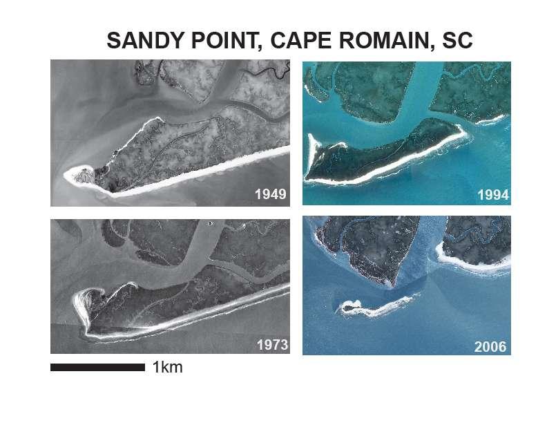
5


6 Black Skimmers Least Terns American Oystercatchers Wilson s Plover Gull-billed Terns Forster s Terns Common Terns Nesting beach bird impacts

7 Is it climate change?


8 Determine the sustainability of coastal ecosystems in the Florida Keys National Wildlife Refuges in the face of climate change and other disturbances, including sea level rise, hurricanes, storm surge, drought, and fire.


9 Florida Keys National Wildlife Refuges The Refuges provide habitats for 31 federally threatened, endangered, and candidate species of which the Key deer, Key Largo woodrat, Key Largo cotton mouse, Lower Keys marsh rabbit, Schaus swallowtail butterfly, Key tree cactus, Big Pine partridge pea, and wedge spurge are found nowhere else in the world. Important stopover for migratory passerines. Hurricane Wilma storm surge in 2005 loss of pines due to saltwater inundation. A half-foot rise in sea level recorded a 70-year period since 1900 reduced the size of pine rockland forest on Sugarloaf Key by 66% Courtesy of The Nature Conservancy Storm events cause considerable physical damage to beach berms and native vegetation along vulnerable shorelines, reducing optimal nesting habitats for sea turtles and shorebirds.
10 Federal Threatened & Endangered Species in the Florida Keys Mammals Key deer Key Largo cotton mouse Key Largo woodrat Lower Keys marsh rabbit Rice rat West Indian manatee Birds Piping plover Roseate tern Red knot (C) Reptiles American crocodile Eastern indigo snake Green sea turtle Hawksbill sea turtle Leatherback sea turtle Loggerhead sea turtle Fish Smalltooth sawfish Key silverside (SSP) Mangrove rivulus (SSP) Invertebrates Schaus swallowtail butterfly Stock Island tree snail Elkhorn coral Staghorn coral Bartram s hairstreak butterfly (C) Florida leafwing butterfly (C) Miami blue butterfly (C) Plants Garber s spurge Key tree-cactus Big Pine partridge pea (C) Blodgett s silverbush (C) Florida indigo (C) Florida semaphore cactus (C) Sand flax (C) Wedge spurge (C) (C) = USFWS Candidate for listing (SSP) = NOAA Species of Special Concern


11 Freshwater wetland, salt marsh & transitional habitats Rice Rat (Oryzomys palustris natator) Lower Keys Marsh Rabbit (Sylvilagus palustris hefneri)


12 Pine rockland forest Florida leafwing butterfly (Anaea troglodyta floridalis) Bartram s hairstreak butterfly (Strymon acis bartrami)

13 The response integrating and developing the science: Vero Beach Field Office small team focused on tracking the relevancy of climate change information both nationally as well as locally. developed climate change language for our various programs reports, biological opinions. in partnership with USGS, alternative futures work by MIT as well as the climate envelop modeling. participated in the Florida FWCC pilot project of combining the MIT alternative futures with the TNC vulnerability assessment methodology.
14 Project Title Organization Principal Investigator(s) Development of high resolution LIDAR-derived digital terrain map and vegetation classification for modeling past vegetation change and future sea level rise scenarios International Hurricane Research Institute, Florida International University Keqi Zhang Plant community response to interactions between disturbance regimes, sea-level rise, and hydrology Analyzing sediment records and slash pine tree rings to establish fire history and vegetation change in pine rockland habitat The role of fire in marsh and buttonwood ecosystems and the abundance of rare plants in coastal habitats in the Lower Florida Keys Post-hurricane responses of rare plant species and vegetation in pine rocklands of the Lower Florida Keys Developing a fire behavior model for the Florida Keys to enhance application of prescribed fire in tropical fuel types Geophysical investigation to evaluate current extent of freshwater lens on Big Pine Key and recommendations for long-term monitoring strategy Vulnerability of Key silverside fish & their habitats to sea level rise Assessing impacts on populations and taking conservation steps for the endangered Key tree cactus Potential impacts from sea level rise on wading bird foraging ecology on the backcountry tidal flats Sustainability of coastal wetlands in the Florida Keys National Wildlife Refuges in the face of climate change and other disturbances, including sea level rise, hurricanes, storm surge, drought, and fire. Southeast Environmental Research Center, Florida International University Laboratory of Paleoenvironmental Research, University of Tennessee Institute for Regional Conservation Institute for Regional Conservation National Fire Sciences Laboratory, U.S. Forest Service TNC & GeoView Fairchild Tropical Botanic Garden Florida Atlantic University Coastal Plant Ecology Laboratory, University of Louisiana-Lafayette Danielle Ogurcak & Mike Ross Sally Horn & Henri Grissini- Mayer Keith Bradley Keith Bradley Matt Jolly Mike Wightman Chuck Getter Joyce Maschinski Dale Gawlik Mark Hester
15 All pertinent questions and research topics based on solid, long term observations, by smart land managers and biologists.... What about the landscape context of their management questions?
16 form follows function.. In response to the need to address questions from the field and to provide an ecosystem/landscape context.. the lack of a landscape scale framework in which to conduct conservation science and its application that integrates all priority taxa and climate change scenario planning... Sam Hamilton (then Director FWS) asked the FWS National Climate Team to propose a joint venture-like idea...
17 Landscape Conservation Cooperatives (LCCs) developed in the FWS Climate Change Strategic Plan, supported by FWS National Science Team Origin

18 Origin LCCs recognized as U.S. Department of Interior priority with DOI Secretary Executive Order Climate Change DOI Secretarial Order No. 3289
19 Landscape Conservation What are they: Self-directed Cooperatives (LCCs) Conservation science partnerships Based on an agreed upon geography To provide the science to inform land use and land management actions With the objective to sustain cultural and natural resources within that landscape
20 Landscape Conservation Cooperatives

21 Landscape Conservation Cooperatives Caribbean LCC


22 Map of SE LCCs Caribbean LCC


23 Peninsular Florida Landscape Conservation Cooperative

24 PFLCC Interim Structure Core Team: FWS, FWC, TNC, FDACS Interagency Coordination Team: FWS, USGS, NPS, FWC LCCs are true cooperatives, formed and directed by land, water, wildlife, and cultural resource managers and interested public and private organizations.


25 PFLCC Vision An integrated partnership venture that uses a strategic, adaptive, science-informed process to identify and manage priority species and habitats, and achieve coordinated conservation at a landscape scale in response to climate change and other threats.
26 Peninsular Florida LCC progress: the emerging science response to climate and other stressors Coordinator selected (Tim Breault), start date June 19, and for now, working from FWC office in Tallahassee. The LCC Coordinator position supported by FWS and state for at least 2 years, beyond that either appropriated or partnership funding. If the Florida LCC follows national trend in LCCs, the a science coordinator may be hired next FY, pending funding and partnership priorities. This fiscal year (2011), FWS will contribute $200 k for the partnership to help develop science products for the FL conservation community.
27


28 CSC and LCCs are a framework or tool supported to achieve more effective conservation it is a framework and a tool only, not the ultimate objective. The framework can only be improved by use, then modification and adjustment to ecoregional culture and conditions. Fish and wildlife biologists/ecologists are not climate scientists; need to consider climate factors that limit species populations and ask the right questions of the climate data and the climate scientists working together. Last thoughts
Backcountry Management. Anne Morkill Wildlife Refuge Manager U.S. Fish & Wildlife Service
 Backcountry Management Anne Morkill Wildlife Refuge Manager U.S. Fish & Wildlife Service Florida Keys National Marine Sanctuary Advisory Council Duck Key, FL February 21, 2012 Overview of National Wildlife
Florida Keys National Wildlife Refuge Complex. Key West NWR Great White Heron NWR National Key Deer NWR Crocodile Lake NWR
 Florida Keys National Wildlife Refuge Complex Key West NWR Great White Heron NWR National Key Deer NWR Crocodile Lake NWR Key West NWR Marquesas Keys and 13 other keys Mission as a preserve and protect
Instructions for Joining the Webinar.
 New Recovery Plan Review from the Gulf of Mexico Alliance Caroline Gorga, Wildlife Legacy Biologist, Florida Fish & Wildlife Conservation Commission Julia Lightner, Fisheries Biologist, Louisiana Department
A Rising Tide: Conserving Shorebirds and Shorebird Habitat within the Columbia River Estuary
 A Rising Tide: Conserving Shorebirds and Shorebird Habitat within the Columbia River Estuary By Vanessa Loverti USFWS Migratory Birds and Habitat Programs, Portland, Oregon May 28, 2014 Outline of Talk
THE GULF COAST VULNERABILITY ASSESSMENT:
 THE GULF COAST VULNERABILITY ASSESSMENT: Amanda Watson GCVA Coordinator Mississippi State University Gulf Coast Prairie LCC June 3, 2015 Webinar Why? Changing Conditions Conservation is increasingly challenging
National Fish and Wildlife Foundation Executive Summary for the American Oystercatcher Business Plan
 National Fish and Wildlife Foundation Executive Summary for the American Oystercatcher Business Plan October 26, 2008 AMOY Exec Sum Plan.indd 1 8/11/09 5:24:00 PM Colorado Native Fishes Upper Green River
2012 Annual Report. Prepared by: Tim Breault, PFLCC Coordinator. 1 P a g e
 2012 Annual Report Prepared by: Tim Breault, PFLCC Coordinator 1 P a g e 2 P a g e Peninsular Florida Geography 3 P a g e Description The Peninsular Florida Landscape Conservation Cooperative (PFLCC) is
Geographic Response Plan Map: SFL-31. Bradley. Map continued Key on: SFL-34. Key. Murray Key XXX SFL Clive Key XXX. SFL31-06 Clive Key
 ! 1550 1450 81 0'0"W # [\ m [] Geographic Response Plan Map: SFL-31 Bradley Map continued on: SFL-34 Jow Kemp Florida Bay 80 52'30"W 25 7'30"N 1550 1350 SFL31-01 Conchie Channel SFL31-02 Oyster Oyster
Wilderness Lost. Cape Romain National Wildlife Refuge. South Carolina Lowcountry Refuge Complex
 Wilderness Lost Cape Romain National Wildlife Refuge South Carolina Lowcountry Refuge Complex Waccamaw NWR 22,859 Acres Santee NWR 12,483 Acres Cape Romain NWR 66,287 Acres Ernest F. Hollings ACE Basin
FWC and Florida s Imperiled Species Management Laura DiGruttolo Florida Fish and Wildlife Conservation Commission Division of Habitat and Species
 FWC and Florida s Imperiled Species Management Laura DiGruttolo Florida Fish and Wildlife Conservation Commission Division of Habitat and Species Conservation Imperiled Species Management Goal With broad
Matagorda Island Marsh Restoration An Adaptive Management Approach by Coastal Bend Bays & Estuaries Program
 Matagorda Island Marsh Restoration An Adaptive Management Approach by Coastal Bend Bays & Estuaries Program 1957: After Levees 1930: Before Levees Matagorda Island: Site Location Texas Coastal Bend Calhoun
Piping Plovers - An Endangered Beach Nesting Bird, and The Threat of Habitat Loss With. Predicted Sea Level Rise in Cape May County.
 Piping Plovers - An Endangered Beach Nesting Bird, and The Threat of Habitat Loss With Thomas Thorsen May 5 th, 2009 Predicted Sea Level Rise in Cape May County. Introduction and Background Piping Plovers
Coastal Wildlife Conservation Initiative
 Coastal Wildlife Conservation Initiative What is the Coastal Wildlife Conservation Initiative? A partnership strategy to address coastal issues that impact wildlife and their habitats USFWS CWCI Vision
Priority Bird Species and Habitats U.S. Gulf Coast
 Priority Bird Species and Habitats U.S. Gulf Coast Important Bird Habitats Along Gulf Coast: Beaches, Barrier Islands & Spoil Islands Emergent Wetlands (Marshes) Intertidal Flats Seagrass Beds Mollusk
Cat Island Chain Restoration Project Brown County Port & Resource Recovery Department
 Cat Island Chain Restoration Project Brown County Port & Resource Recovery Department February 2, 2015 Fox River and Lower Green Bay Cat Island Chain - 1938 Cat Island Brown County Aerial Photography,
Species Response to Habitat Restoration and Management in San Francisco Bay
 Species Response to Habitat Restoration and Management in San Francisco Bay Joy Albertson, U.S. Fish and Wildlife Service October 11, 2017 2017 State of the San Francisco Estuary Conference Past (~1850)
Piping Plovers in Jamaica Bay
 Piping Plovers in Jamaica Bay Hanem Abouelezz, Biologist Jamaica Bay Unit Gateway National Recreation Area National Park Service Threatened and Endangered Species Our mission is to reduce the risk of
Habitat Use by Wildlife in Agricultural and Ranching Areas in the Pantanal and Everglades. Dr. Júlio Cesar de Souza and Dr. Elise V.
 Habitat Use by Wildlife in Agricultural and Ranching Areas in the Pantanal and Everglades Dr. Júlio Cesar de Souza and Dr. Elise V. Pearlstine Pantanal 140,000 km 2 of wetlands with a monomodal flood pulse
SENATE CONCURRENT RESOLUTION No. 158 STATE OF NEW JERSEY. 217th LEGISLATURE INTRODUCED JUNE 26, 2017
 SENATE CONCURRENT RESOLUTION No. STATE OF NEW JERSEY th LEGISLATURE INTRODUCED JUNE, 0 Sponsored by: Senator JEFF VAN DREW District (Atlantic, Cape May and Cumberland) Senator ROBERT M. GORDON District
Marine Corps Support Facility-Blount Island: Integrated Natural Resources Program Successes. E2S2 Conference May 12, 2011
 Marine Corps Support Facility-Blount Island: Integrated Natural Resources Program Successes E2S2 Conference May 12, 2011 Shari Kennedy, MCSF-BI Robert Price, CH2M HILL Location Mission The mission of Marine
Instructor Guide: Birds in Human Landscapes
 Instructor Guide: Birds in Human Landscapes Authors: Yula Kapetanakos, Benjamin Zuckerberg Level: University undergraduate Adaptable for online- only or distance learning Purpose To investigate the interplay
National Audubon Society. Coastal Bird Conservation Program
 National Audubon Society Coastal Bird Conservation Program Coastal Bird Conservation Program This presentation contains original photos and data. For any use of this information, data, maps, or photographs
Picayune Strand Restoration Project in Southwest Florida A Landscape Perspective
 U.S. Fish and Wildlife Service Restoring America s Everglades-Recovering Multiple Species Picayune Strand Restoration Project in Southwest Florida A Landscape Perspective Kim Dryden U.S. Fish and Wildlife
A View from the Gulf Coast: How Does All This Stuff Add Up?
 A View from the Gulf Coast: How Does All This Stuff Add Up? John Tirpak, PhD Science Coordinator, USFWS Gulf Restoration Program Lafayette, LA January 21, 2016 Mississippi River Basin/Gulf Hypoxia Initiative
Ms. Robyn Thorson Director, Region 1 U.S. Fish and Wildlife Service 911 NE 11 th Avenue Portland, Oregon November Dear Ms.
 Ms. Robyn Thorson Director, Region 1 U.S. Fish and Wildlife Service 911 NE 11 th Avenue Portland, Oregon 97232 16 November 2009 Dear Ms. Thorson, For the last decade, U.S. Shorebird Conservation Plan partners
Dredging, Beach Nourishment and. Bird Conservation Workshop Atlantic Coast Region
 Dredging, Beach Nourishment and US Army Corps Bird Conservation Workshop Atlantic Coast Region Beach Nourishment and Bird Habitat Restoration in Southern New Jersey Shore Protection and Ecosystem Restoration
Red-breasted Merganser Minnesota Conservation Summary
 Credit Jim Williams Red-breasted Merganser Minnesota Conservation Summary Audubon Minnesota Spring 2014 The Blueprint for Minnesota Bird Conservation is a project of Audubon Minnesota written by Lee A.
1. Qualitative Assessment... II-101
 Table of Contents I. Introduction... I-1 A. Session Law 2009-479 / House Bill 709... I-2 B. Public Consultation... I-3 C. Selection of Study Sites... I-5 D. Limitations of Study... I-8 II. Physical Assessment...
Geographic [x Response Plan Map: GA-12 [r. Map Continued on GA-8 XXX. GA12-01 Green Island Sound. OSSABAW ISLAND WMA Raccoon Key XXX
 Charles Ogeechee River tal Waterway 31 52'30"N Little Ogeechee River Harveys Island 81 7'30"W Charles Rush Charles 950 Ogeechee River Geographic Response Plan Map: GA-12 Map Continued on GA-8 Green Island
Expansion Work Has Begun The perimeter dike for Cell 7 is now visible
 Summer/Fall 2017 In This Issue Poplar Island Expansion Wetland Cell 5AB Development Wildlife Update Birding tours on Poplar Island Expansion Work Has Begun The perimeter dike for Cell 7 is now visible
Cape Romain National Wildlife Refuge Climate Change Impacts
 Climate Change Impacts How will the Refuge be Affected by Climate Change? Salt marsh fragmentation by rapidly eroding tidal creeks Salt marsh submergence during high tide events leading to habitat conversion
CHAPTER. Coastal Birds CONTENTS. Introduction Coastal Birds Action Plan. 108 cbbep.org
 CHAPTER 9 Coastal Birds CONTENTS Introduction Coastal Birds Action Plan 108 cbbep.org Introduction The South Texas coast is one of the most unique areas in North America and is renowned for its exceptional
Collaboration and Planning to Implement the South San Diego Bay Restoration and Enhancement Project
 Collaboration and Planning to Implement the South San Diego Bay Restoration and Enhancement Project Carolyn Lieberman Coastal Program Coordinator for Southern California U.S. Fish and Wildlife Service
OVERVIEW INTRODUCTION TO SHOREBIRDS MANAGEMENT FOR SHOREBIRDS TVA REGIONAL SHOREBIRD PROJECT ESTIMATING SHOREBIRD NUMBERS
 SHOREBIRD CONSERVATION AND MONITORING RESOURCES US SHOREBIRD CONSERVATOIN PLAN http://www.fws.gov/shorebirdplan WATERFOWL MANAGEMENT HANDBOOK - http://www.nwrc.usgs.gov/wdb/pub/wmh/contents.html MANOMET
Oregon Dunes National Recreation Area BCS Number: 47-5
 Oregon Dunes National Recreation Area BCS Number: 47-5 ***NOTE: We were unable to determine all necessary information for this site description. If you would like to contribute the needed information to
Bird Species of Special Concern
 Bird Species of Special Concern Florida Keys NWR Complex Kate G. Watts, Lead Wildlife Biologist Bird Species of Special Concern White-crowned Pigeon Reddish Egret Magnificent Frigatebird Great White Heron
Update on American Oystercatcher Reseach and Conservation in New Jersey
 Update on American Oystercatcher Reseach and Conservation in New Jersey - 2007 Todd Pover, New Jersey Division of Fish and Wildlife - Endangered and Nongame Species Program Tom Virzi, PhD Candidate Department
Geographic Response Plan Map: SFL-41
 ! 400!!!! iscayne Bay Aquatic reserve ey X 25 22'30"N Map continued on: SFL-42 k Barnes Sound SFL42-01 FKNMS SFL-42 u Florida Keys ational Marine Sanctuary 25 15'0"N 80 22'30"W Environmentally Sensitive
Shorebird Migration in Nebraska: Stopover Habitat Decisions in a Vanishing Landscape. Caitlyn Gillespie and Joseph J. Fontaine
 Shorebird Migration in Nebraska: Stopover Habitat Decisions in a Vanishing Landscape Caitlyn Gillespie and Joseph J. Fontaine Nebraska Cooperative Fish and Wildlife Research Unit School of Natural Resources
Chesapeake Bay adaptation Designing marshes for David Curson, National Audubon Society Erik Meyers, The Conservation Fund
 Chesapeake Bay adaptation Designing marshes for 2100 David Curson, National Audubon Society Erik Meyers, The Conservation Fund Blackwater National Wildlife Refuge Maryland s Everglades Biological Resources:
United States Department of the Interior
 Jim Sopher Project Manager RAM Realty Services 4801 PGA Boulevard Palm Beach Gardens, Florida 33418 Dear Mr. Sopher: United States Department of the Interior FISH AND WILDLIFE SERVICE South Florida Ecological
Geographic Response Plan Map: EFL-56. Map Continued on Page: GA-37. George Crady Fishing Pier State Park. Amelia Island State Park
 30 37'30"N 81 30'0"W Big Piney Island Nassau River - St. Johns River Marshes k Aquatic Preserve!d!] Crane Island AB A1A ") 108! Geographic Response Plan Map: EFL-56 AB 200 Map Continued on Page: GA-37
Beach nesting birds ATLANTIC FLYWAY SHOREBIRD INITIATIVE
 Beach nesting birds ATLANTIC FLYWAY SHOREBIRD INITIATIVE Beach nesting birds Beach nesting birds Species Focal Species USSCP Status High Concern Estimated Population Population trend (30-year) American
Wulfert Bayous Land Acquisition Campaign. Preserve. Protect. Inspire. Ding Darling Wildlife Society
 Wulfert Bayous Land Acquisition Campaign Preserve. Protect. Inspire. Ding Darling Wildlife Society Project Overview Wulfert Bayous is the largest unprotected property on Sanibel Island, and is adjacent
Wetland Restoration at Blackwater NWR. Dixie Birch November 2, 2006
 Wetland Restoration at Blackwater NWR Dixie Birch November 2, 2006 Goal: Restore 20,000 acres In Dorchester County including 11,000 at Blackwater Strategic Partnerships Remaining marsh shown in red Blackwater
Bird Habitat Conservation at Various Scales in the Atlantic Coast Joint Venture 1
 Bird Habitat Conservation at Various Scales in the Atlantic Coast Joint Venture 1 Andrew Milliken, 2 Craig Watson, 3 and Chuck Hayes 4 Abstract The Atlantic Coast Joint Venture is a partnership focused
Golden Eagle (Aquila chrysaetos) Management Indicator Species Assessment Ochoco National Forest
 Management Indicator Species Assessment Ochoco National Forest") Golden Eagle (Aquila chrysaetos) Management Indicator Species Assessment Ochoco National Forest I. Introduction The golden eagle was chosen as a terrestrial management indicator species (MIS) on the Ochoco
Golden Eagle (Aquila chrysaetos) Management Indicator Species Assessment Ochoco National Forest I. Introduction The golden eagle was chosen as a terrestrial management indicator species (MIS) on the Ochoco
Resilient Birds, Devoted Advocates 2016 Coastal Bird Conservation Results. Spring American Oystercatcher Photo by Matt Filosa
 Resilient Birds, Devoted Advocates 2016 Coastal Bird Conservation Results Spring 2017 American Oystercatcher Photo by Matt Filosa Florida s coastal birds face long odds, but Audubon support gives them
MANUAL FOR BUILDING OWNERS AND CONTRACTORS ACCESSING ROOFTOPS WITH PROTECTED NESTING BIRDS
 Least Tern and chick Doug Clark MANUAL FOR BUILDING OWNERS AND CONTRACTORS ACCESSING ROOFTOPS WITH PROTECTED NESTING BIRDS WHAT PROTECTED BIRDS ARE PRESENT ON ROOFTOPS? Many of Florida s birds are at risk
The North American Wetlands Conservation Act: Working for Maine
 The North American Wetlands Conservation Act: Working for Maine The North American Wetlands Conservation Act (NAWCA) is an incentive-based, landowner-friendly program that fosters the development of public-private
Magic in the Mangroves: A Profile of Mangrove Communities
 Magic in the Mangroves: A Profile of Mangrove Communities What is a Mangrove? A mangrove is a tree that is found in tropical and sub-tropical areas, usually in estuarine waters. The mangrove is a halophyte,,
2/26/ % located in Collier, Lee, Monroe, Dade Ten Thousand Islands region Tampa Bay & Indian River Lagoon Largest mangrove forest in USA
 Mangroves Florida: 190,000 hectares of mangrove 90% located in Collier, Lee, Monroe, Dade Ten Thousand Islands region Tampa Bay & Indian River Lagoon Largest mangrove forest in USA Mangroves: tropical
Natural resource indicators and targets
 Natural resource indicators and targets Overview Approved by Steering Committee: March 20, 2013 The 2-4 year mission of the South Atlantic LCC is to design a shared blueprint for landscape conservation
Maryland Coastal Bays Colonial Waterbird and Islands Report 2018
 Maryland Coastal s Colonial Waterbird and Islands Report 2018 THE REPORT This report provides an assessment of the current state of colonial waterbird breeding in the Coastal s of Maryland behind Ocean
North American Wetlands Conservation Council (Canada)
") North American Wetlands Conservation Council (Canada) STRATEGIC PLAN 2010-2020 North American Wetlands W Conservation v Council (Canada) North American Wetlands Conservation Council (Canada) Strategic
North American Wetlands Conservation Council (Canada) STRATEGIC PLAN 2010-2020 North American Wetlands W Conservation v Council (Canada) North American Wetlands Conservation Council (Canada) Strategic
T.S Roberts Bird Sanctuary Improvements Project
 T.S Roberts Bird Sanctuary Improvements Project Dr. David Zumeta Ornithology and Forest Habitat Expert Jason Aune Landscape Architect, AFLA Tyler Pederson Project Manager Michael Schroeder Assistant Superintendent
ANNE VALLEE (TRIANGLE ISLAND) ECOLOGICAL RESERVE
 ECOLOGICAL RESERVE") ANNE VALLEE (TRIANGLE ISLAND) ECOLOGICAL RESERVE PURPOSE STATEMENT February 2003 ANNE VALLEE (TRIANGLE ISLAND) ECOLOGICAL RESERVE Purpose Statement Ecological reserves are areas selected to preserve representative
ANNE VALLEE (TRIANGLE ISLAND) ECOLOGICAL RESERVE PURPOSE STATEMENT February 2003 ANNE VALLEE (TRIANGLE ISLAND) ECOLOGICAL RESERVE Purpose Statement Ecological reserves are areas selected to preserve representative
USFWS Migratory Bird Program
 USFWS Migratory Bird Program Updates for the Bird Conservation Committee North American Wildlife & Natural Resources Conference Norfolk, Va. ~ March 28, 2018 Presented by Sarah Mott & Ken Richkus U.S.
Project Summary. Predicting waterbird nest distributions on the Yukon-Kuskokwim Delta of Alaska
 Project Summary 1. PROJECT INFORMATION Title Project ID Predicting waterbird nest distributions on the Yukon-Kuskokwim Delta of Alaska WA2012_22 Project Period July 1, 2012 to June 30, 2014 Report submission
Field Trip to PATUXENT REFUGE
 Field Trip to PATUXENT REFUGE Type to enter text THE THIRD GRADE STUDENTS OF MS. SMITH BARRETT ELEMENTARY SCHOOL ARLINGTON, VIRGINIA CHAPTER 1 INTRODUCTION Introduction continued President Theodore Roosevelt
BIRD READING ASSIGNMENT
 Ocean Connectors BIRD READING ASSIGNMENT To do before the field trip, in class or at home 1. Students will read Wetland Neighbors. The reading is available on the next page and online at http://oceanconnectors.org/resources.
Endangered Species Monitoring - Northern Coastline of New Jersey
 Endangered Species Monitoring - Northern Coastline of New Jersey By: Mark H. Burlas, Sr. Wildlife Biologist U.S. Army Corps of Engineers New York District Planning Division Presentation Format Project
2006 Beach nesting Bird Census and Report for Coastal Mississippi
 National Audubon Society Coastal Bird Conservation Program 2006 Beach nesting Bird Census and Report for Coastal Mississippi Margo Zdravkovic National Audubon Society Coastal Bird Conservation Program
Ruddy Turnstone. Appendix A: Birds. Arenaria interpres [M,W] New Hampshire Wildlife Action Plan Appendix A Birds-50
![Ruddy Turnstone. Appendix A: Birds. Arenaria interpres [M,W] New Hampshire Wildlife Action Plan Appendix A Birds-50](/thumbs/89/101188544.jpg "Ruddy Turnstone. Appendix A: Birds. Arenaria interpres [M,W] New Hampshire Wildlife Action Plan Appendix A Birds-50") Ruddy Turnstone Arenaria interpres [M,W] Federal Listing State Listing Global Rank State Rank Regional Status N/A N/A G5 SNR Very High Photo by Pamela Hunt Justification (Reason for Concern in NH) Populations
Ruddy Turnstone Arenaria interpres [M,W] Federal Listing State Listing Global Rank State Rank Regional Status N/A N/A G5 SNR Very High Photo by Pamela Hunt Justification (Reason for Concern in NH) Populations
Grey County Natural Heritage System Study
 Grey County Natural Heritage System Study Green in Grey Technical Advisory Committee Meeting #1 February 25, 2015 225 Labrador Drive, Unit 1, Waterloo, Ontario, N2K 4M8 Tel: (519) 725-2227 Web: www.nrsi.on.ca
Whimbrel. Appendix A: Birds. Numenius phaeopus [M] New Hampshire Wildlife Action Plan Appendix A Birds-225
![Whimbrel. Appendix A: Birds. Numenius phaeopus [M] New Hampshire Wildlife Action Plan Appendix A Birds-225](/thumbs/85/92702470.jpg "Whimbrel. Appendix A: Birds. Numenius phaeopus [M] New Hampshire Wildlife Action Plan Appendix A Birds-225") Whimbrel Numenius phaeopus [M] Federal Listing State Listing Global Rank State Rank Regional Status N/A N/A G5 SNR Very High Photo by Pamela Hunt Justification (Reason for Concern in NH) Populations of
Whimbrel Numenius phaeopus [M] Federal Listing State Listing Global Rank State Rank Regional Status N/A N/A G5 SNR Very High Photo by Pamela Hunt Justification (Reason for Concern in NH) Populations of
Smith River Mouth BCS number: 86-6
 Smith River Mouth BCS number: 86-6 ***NOTE: We were unable to determine all necessary information for this site description. If you would like to contribute the needed information to this description,
Citizen Science Strategy for Eyre Peninsula DRAFT
 Citizen Science Strategy for Eyre Peninsula 1 What is citizen science? Citizen science is the practice of professional researchers engaging with the public to collect or analyse data within a cooperative
Geographic [ Response Plan Map: GA-9. Map Continued on GA-5 FORT PULASKI. Shad River XXX. GA9-01 Lazaretto Creek West.
 of ake) rsh Creek s Creek!S(!d Chatham County!h Wilmington River Odingsell River D EFUGE 32 0'0"N Map Continued on GA-8 31 52'30"N 81 0'0"W 450 Odingsell River 350 Wilmington River Romerly Marsh Creek
RECENT CHANGES TO THE ILLINOIS SMCRA THREATENED AND ENDANGERED SPECIES (T&E) REQUIREMENTS
 REQUIREMENTS") RECENT CHANGES TO THE ILLINOIS SMCRA THREATENED AND ENDANGERED SPECIES (T&E) REQUIREMENTS William O Leary, M.S. and Amanda Pankau, M.S. HDR Engineering Murphysboro, IL ILLINOIS SMCRA T&E HISTORY 1983 2009
RECENT CHANGES TO THE ILLINOIS SMCRA THREATENED AND ENDANGERED SPECIES (T&E) REQUIREMENTS William O Leary, M.S. and Amanda Pankau, M.S. HDR Engineering Murphysboro, IL ILLINOIS SMCRA T&E HISTORY 1983 2009
DOWNLOAD OR READ : NEW JERSEY WILDLIFE VIEWING GUIDE WILDLIFE VIEWING GUIDES SERIES PDF EBOOK EPUB MOBI
 DOWNLOAD OR READ : NEW JERSEY WILDLIFE VIEWING GUIDE WILDLIFE VIEWING GUIDES SERIES PDF EBOOK EPUB MOBI Page 1 Page 2 new jersey wildlife viewing guide wildlife viewing guides series new jersey wildlife
Bird Conservation Priorities for the Mid-Atlantic & New England Coast Mitschka Hartley & Melanie Steinkamp
 Bird Conservation Priorities for the Mid-Atlantic & New England Coast Mitschka Hartley & Melanie Steinkamp U.S. Fish & Wildlife Service Atlantic Coast Joint Venture Bird Conservation Priorities Overview
REVISED DRAFT - 8/21/00 BIOLOGICAL OPINION ON THE OPERATION OF THE MISSOURI RIVER MAIN STEM RESERVOIR SYSTEM,
 REVISED DRAFT - 8/21/00 BIOLOGICAL OPINION ON THE OPERATION OF THE MISSOURI RIVER MAIN STEM RESERVOIR SYSTEM, OPERATION AND MAINTENANCE OF THE MISSOURI RIVER BANK STABILIZATION AND NAVIGATION PROJECT,
Distribution of Piping Plover and Coastal Birds in Relation to Federal Activities on the Southern Coast of Long Island
 U.S. U.S. Fish Fish & Wildlife & Wildlife Service Service Distribution of Piping Plover and Coastal Birds in Relation to Federal Activities on the Southern Coast of Long Island Implications for Project
Chapter 2. Minnesota Species in Greatest Conservation Need
 Chapter 2. Minnesota Species in Greatest Conservation Need Definition States were required in the development of their 2005 Wildlife Action Plans to identify species in greatest conservation need and to
NPS Inventory and Monitoring Program
 NPS Inventory and Monitoring Program Metrics and Protocols Monitoring Tidal Marsh Condition Tidal Marsh Resiliency Coordination Workshop U.S. Fish & Wildlife Service, Hadley, MA Dec 8-9, 2014 Northeast
Saugus. Produced in This report and associated map provide information about important sites for biodiversity conservation in your area.
 CONSERVING THE BIODIVERSITY OF MASSACHUSETTS IN A CHANGING WORLD Saugus Produced in 2012 This report and associated map provide information about important sites for biodiversity conservation in your area.
Florida Fish and Wildlife Conservation Commission
 Florida Fish and Wildlife Conservation Commission Endangered and Threatened Species Management and Conservation Plan Progress Report Fiscal Year 2016-17 December 1, 2017 E n d a n g e r e d a n d T h r
Geographic Response Plan Map: SC-50. Map Continued on SC-42. St Helena Sound. SC50-04 Ashepoo River. Combahee. Bank
 Back -05 e Morgan Village Creek # 32 30'0"N Beaufort County Coosaw R Creeks Map Continued on SC-49 750 900 SC42-03 ICWW - 80 30'0"W Coosaw River iver 1050 1050 Coosaw River Morgan Back Creeks Village Creek
Richard A. Fischer, Ph.D. U.S. Army Engineer Research and Development Center Environmental Laboratory
 Regional Sediment Management - Beneficial Uses of Dredged Material Along Lake Erie and Tributaries Section 204 of the 1992 Water Resources Development Act Richard A. Fischer, Ph.D. U.S. Army Engineer Research
United States Department of the Interior
 United States Department of the Interior Mickey T. Sugg Wilmington Regulatory Field Office U. S. Army Corps of Engineers 69 Darlington Ave. Wilmington, North Carolina 28403 FISH AND WILDLIFE SERVICE Raleigh
Protecting Beach-nesting Birds in Louisiana VOLUNTEER TRAINING
 Protecting Beach-nesting Birds in Louisiana VOLUNTEER TRAINING How Many Bird Species in Louisiana? a. 120 b. 280 c. 480 Year-round Residents Nearctic-Neotropic Migrants W. Dave Patton Eric Liffmann Winter
Welcome to: Mangroves A to Z. Special thanks:
 Welcome to: Mangroves A to Z Special thanks: Our Presenters: Wayne Blythe, SFWMD Heather Carman, SFWMD Richard Cervi, Cervi Associates Katy Collins, FDEP Kate Davis, Davis Environmental Solutions Brandon
Willet. Appendix A: Birds. Tringa semipalmata. New Hampshire Wildlife Action Plan Appendix A Birds-356
 Willet Tringa semipalmata Federal Listing State Listing Global Rank State Rank Regional Status N/A SC G5 S3 Very High Photo by Pamela Hunt Justification (Reason for Concern in NH) Birds that breed in salt
R. Griswold Snowy Plover/Least Tern Monitoring Project 2009
 R. Griswold Snowy Plover/Least Tern Monitoring Project 2009 Identification California Least Tern Endangered 9-10 Nests in colonies Dives from air for fish Parents feed young Nesting colony can be fenced
Florida Field Naturalist
 Florida Field Naturalist PUBLISHED BY THE FLORIDA ORNITHOLOGICAL SOCIETY VOL. 29, NO. 3 SEPTEMBER 2001 PAGES 75-112 Florida Field Naturalist 29(3):75-80, 2001. AMERICAN OYSTERCATCHERS NEST ON GRAVEL-COVERED
Species of Greatest Conservation Need Priority Species for NYC Audubon. May 12, Susan Elbin Director of Conservation and Science
 Species of Greatest Conservation Need Priority Species for NYC Audubon May 12, 2011 Susan Elbin Director of Conservation and Science Working List of Species Species on the current federal or state list
Measuring changes in a rapidly changing climate and landscape.
 Measuring changes in a rapidly changing climate and landscape. Intrinsic worth Camping Fishing Hiking Watching the sunset...what if there was no natural soundtrack? Birds in cages, Beijing Birds are nature
Geographic Response Plan Map: GA-2. Raptor Nesting Area. Recreational Fishing. Sea Turtles. Shorebird Nesting Area. Wading birds Nesting Area
 81 7'30"W Geographic Response Plan Map: GA-2 81 0'0"W 32 15'0"N 32 15'0"N Union Creek «46 Jasper Beaufort «170 Sector Charleston Sava n nah «170 and 2 AH NATIONAL FE REFUGE Middle River GA1-07 Steam Boat
MODIFICATIONS TO THE C-111 SOUTH DADE PROJECT, L-31W
 APPENDI A MODIFICATIONS TO THE C-111 SOUTH DADE PROJECT, L-31W BIOLOGICAL ASSESSMENT U.S. FISH AND WILDLIFE SERVICE DEPARTMENT OF THE ARMY JACKSONVILLE DISTRICT CORPS OF ENGINEERS 701 San Marco Boulevard
ENVIRONMENTAL DEPARTMENT. Town Council Workshop March 9, 2017
 ENVIRONMENTAL DEPARTMENT Town Council Workshop March 9, 2017 Manage, promote and maintain the Town's natural resources through research, monitoring, management, and public education. 2 Staff Members Jim
Species Conclusions Table
 Project Manager: Melissa Nash Project Name: Sandbridge Road/Nimmo VII-A Project Description:City of Virginia Beach safety improvements to Sandbridge Rd from McClanan s Curve to one mile east of intersection
Anthony Gonzon DE Division of Fish & Wildlife DNREC
 Anthony Gonzon DE Division of Fish & Wildlife DNREC Thousands of birds migrate through Delaware every Fall Fall migration Sept Nov Thousands more call Delaware home in winter Nov Mar Wide-ranging diversity
Updated Distribution of the Lower Keys Marsh Rabbit
 Research Note Updated Distribution of the Lower Keys Marsh Rabbit CRAIG A. FAULHABER, 1 Department of Wildlife and Fisheries Sciences, Texas A&M University, College Station, TX 77843, USA NEIL D. PERRY,
SPECIAL PLACES AT RISK IN THE GULF
 SPECIAL PLACES AT RISK IN THE GULF IMPACTS OF THE BP OIL CATASTROPHE the ROCKY MOUNTAIN CLIMATE Organization Principal Authors Stephen Saunders Tom Easley The Rocky Mountain Climate Organization Contributing
Toronto s Urban Wilderness
 Tommy Thompson Park Toronto s Urban Wilderness Park History Early Construction Construction began in 1959 by Toronto Harbour Commissioners Expand port related facilities Dispose of rubble and fill from
Black-crowned Night-heron Minnesota Conservation Summary
 Credit Deborah Reynolds Black-crowned Night-heron Minnesota Conservation Summary Audubon Minnesota Spring 2014 The Blueprint for Minnesota Bird Conservation is a project of Audubon Minnesota written by
McKay Creek National Wildlife Refuge BCS number: 48-19
 Oregon Coordinated Aquatic Bird Monitoring: Description of Important Aquatic Bird Site McKay Creek National Wildlife Refuge BCS number: 48-19 Site description author(s) Howard Browers, Supervisory Wildlife
Threatened and Endangered Species Team (TEST)
") Threatened and Endangered Species Team (TEST) Richard A. Fischer, Ph.D. Research Wildlife Biologist USACE ERDC Environmental Laboratory 9 March 2016 Fischer US Army Corps of Engineers Hoover/Killgore Research
Threatened and Endangered Species Team (TEST) Richard A. Fischer, Ph.D. Research Wildlife Biologist USACE ERDC Environmental Laboratory 9 March 2016 Fischer US Army Corps of Engineers Hoover/Killgore Research
 Conservation of intertidal habitats and migratory waterbirds of the East Asian-Australasian Flyway, especially the Yellow Sea, in a global context Nicola.Crockford@rspb.org.uk Sponsor: BirdLife International