Matagorda Island Marsh Restoration An Adaptive Management Approach by Coastal Bend Bays & Estuaries Program
|
|
|
- Patricia Conley
- 5 years ago
- Views:
Transcription


1 Matagorda Island Marsh Restoration An Adaptive Management Approach by Coastal Bend Bays & Estuaries Program 1957: After Levees 1930: Before Levees


2 Matagorda Island: Site Location Texas Coastal Bend Calhoun County Aransas National Wildlife Refuge Matagorda Island Unit 15,000 acre Western Marsh
3 Matagorda Island: Site History 1930s little evidence of human impact 1940s 1960s taken over by the Air Force, no public access was allowed Matagorda Island Bombing and Gunnery Range system of levees and ditches partitioned the site by mid 1950s active dewatering was initiated 1970s 1990s ownership transferred to U.S. FWS and TPWD U.S. FWS: habitat and wildlife management (migratory birds, Whooping Cranes) TPWD: public use management 2000s today U.S. FWS: on-going effort to restore hydrology to 1930s conditions

4 1930: No Levees More Open Water

5 1957: Levees More Sand and Mudflats

6 2007: Significant Non-Native Vegetation


7 Project Goal Maximize productivity within 15,000 acres on Matagorda Island by enhancing tidal circulation and water exchange. USFWS State and Federally Listed Species of Concern Found on Matagorda Island American Alligator, Aplomado Falcon, Arctic Peregrine Falcon, Bald Eagle, Botteri s Sparrow*, Brown Pelican, Green Sea Turtle, Hawksbill Sea Turtle, Kemp s Ridley Sea Turtle, Least Tern, Leatherback Sea Turtle, Loggerhead Sea Turtle, Mountain Plover, Peregrine Falcon, Piping Plover, Reddish Egret, Roseate Tern*, Sooty Tern*, Southern Yellow Bat, Swallow-tailed Kite, Texas Diamondback Terrapin, Texas Horned Lizard, West Indian Manatee*, White-faced Ibis, White-tailed Hawk, Whooping Crane, Wood Stork, Zone-tailed Hawk (* = Species outside of its normal range)
8 Management Plan: Objectives In 2006, the Refuge approached CBBEP to seek funding assistance for the development of a comprehensive management plan that would: 1. Increase tidal exchange between the bay and marsh system. 2. Promote circulation and exchange between interior cells. 3. Reduce maintenance costs for existing system of control structures. 4. Maintain access via critical levee roads for monitoring and law enforcement.
9 Management Plan: Considerations Difficulty of data collection and site characterization very little or no existing tide, current, or water quality data very large, complex site (15,000 acre marsh complex) remote location (boat/barge access only) Maintain interior levee system for transportation and maintenance Other levees: Removal preferred, but some locations must be intact to allow access to other locations may necessitate delaying restoration at higher priority locations Ability to complete restoration actions in phases allow for varying amounts of available funding no work during Whooping Crane wintering season (October 15 April 15) majority of construction window coincides with hurricane season

10 Adaptive Management Plan (AMP) Matagorda Island s 15,000-acre Western Marsh is a large and complex system. Any attempt at a comprehensive characterization would be difficult and expensive. An adaptive management approach was utilized to minimize initial planning and development costs. figure out what you want, figure out how it works, make a change, figure out what happened, and do it better the next time. - Joe Billy Bob (HDR)

11 AMP: Goals and Targets

12 AMP: Conceptualization of System

13 AMP: Conceptualization of System


14 AMP: Learning (Monitoring)

15 AMP: Process for Improving Future Management Decisions

16 AMP: Phase 1 Prioritized Restoration Action Locations
 to enhance flow?")
17 Restoration Actions: Construction Considerations Minimize Design Costs Standardized Set of 3 Culverts Initial restoration actions consisted mostly of culvert installation/replacement Focus is gradually shifting towards levee removal Future: additional earthwork (new channels) to enhance flow??


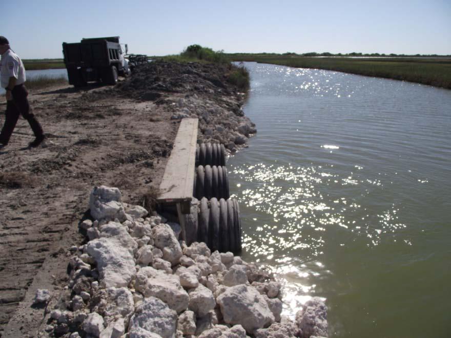

18 Restoration Actions: Outer Rim Culvert Replacement Before After


19 Restoration Actions: Redfish Landing Culvert Replacement Before After


20 Restoration Actions: Darkwater Levee Removal Before


21 Restoration Actions: Darkwater Levee Removal After
22 Restoration Actions: Benefit Map
23 Summary of Project Accomplishments Development of Matagorda Island Adaptive Management Plan (Phase 1 and Phase 2) Restoration actions completed at 11 locations Enhanced circulation throughout approximately 3,100 acres of wetlands Treated approximately 400 acres of uplands for non-native vegetation Finishing second round of the adaptive management cycle Starting third round of prioritizing action items
24 Funding and Project Partners Total Project Funding Through CBBEP: $630,000 $410,000 TCEQ/EPA; $220,000 USFWS-Coastal Program $70,000 AMP Development and Updates; $560,000 Restoration Actions Key Funding Partners U.S. Fish & Wildlife Service-Aransas National Wildlife Refuge U.S. Fish & Wildlife Service-Coastal Program Texas Commission on Environmental Quality U.S. Environmental Protection Agency Gulf of Mexico Program Friends of Aransas and Matagorda Island Tivoli Independent School District Texas General Land Office-Coastal Impact Assistance Program (future funding partner) HDR Engineering, Inc
25 References and Contact Information CBBEP (follow link to Featured Projects ) U.S. FWS Aransas National Wildlife Refuge Dustin Cravey Project Manager Coastal Bend Bays & Estuaries Program dcravey@cbbep.org

26 Discussion / Questions
Collaboration and Planning to Implement the South San Diego Bay Restoration and Enhancement Project
 Collaboration and Planning to Implement the South San Diego Bay Restoration and Enhancement Project Carolyn Lieberman Coastal Program Coordinator for Southern California U.S. Fish and Wildlife Service
Ray Allen Executive Director (361)
") Ray Allen Executive Director (361)885-6204 rallen@cbbep.org www.cbbep.org CBBEP History 1987 U.S. Congress established the National Estuary Program (NEP) to promote longterm planning and management of
Ray Allen Executive Director (361)885-6204 rallen@cbbep.org www.cbbep.org CBBEP History 1987 U.S. Congress established the National Estuary Program (NEP) to promote longterm planning and management of
Backcountry Management. Anne Morkill Wildlife Refuge Manager U.S. Fish & Wildlife Service
 Backcountry Management Anne Morkill Wildlife Refuge Manager U.S. Fish & Wildlife Service Florida Keys National Marine Sanctuary Advisory Council Duck Key, FL February 21, 2012 Overview of National Wildlife
Florida Keys National Wildlife Refuge Complex. Key West NWR Great White Heron NWR National Key Deer NWR Crocodile Lake NWR
 Florida Keys National Wildlife Refuge Complex Key West NWR Great White Heron NWR National Key Deer NWR Crocodile Lake NWR Key West NWR Marquesas Keys and 13 other keys Mission as a preserve and protect
Humboldt Bay NWR BCS number: 86-4
 Humboldt Bay NWR BCS number: 86-4 ***NOTE: We were unable to determine all necessary information for this site description. If you would like to contribute the needed information to this description, please
National Audubon Society. Coastal Bird Conservation Program
 National Audubon Society Coastal Bird Conservation Program Coastal Bird Conservation Program This presentation contains original photos and data. For any use of this information, data, maps, or photographs
Siletz Bay BCS number: 47-29
 Siletz Bay BCS number: 47-29 ***NOTE: We were unable to determine all necessary information for this site description. If you would like to contribute the needed information to this description, please
Picayune Strand Restoration Project in Southwest Florida A Landscape Perspective
 U.S. Fish and Wildlife Service Restoring America s Everglades-Recovering Multiple Species Picayune Strand Restoration Project in Southwest Florida A Landscape Perspective Kim Dryden U.S. Fish and Wildlife
Oil Spill Funds and the Opportunities they Present for Galveston Bay
 Oil Spill Funds and the Opportunities they Present for Galveston Bay A presentation to Texas Environmental Grantmakers Group By Bob Stokes, President, Galveston Bay Foundation Friday, October 31, 2014
Oregon Dunes National Recreation Area BCS Number: 47-5
 Oregon Dunes National Recreation Area BCS Number: 47-5 ***NOTE: We were unable to determine all necessary information for this site description. If you would like to contribute the needed information to
Sauvie Island Wildlife Area BCS number: 47-28
 Sauvie Island Wildlife Area BCS number: 47-28 Site description author(s) Mark Nebeker, Oregon Department of Fish and Wildlife, Sauvie Island Wildlife Area Manager Primary contact for this site Mark Nebeker,
R. Griswold Snowy Plover/Least Tern Monitoring Project 2009
 R. Griswold Snowy Plover/Least Tern Monitoring Project 2009 Identification California Least Tern Endangered 9-10 Nests in colonies Dives from air for fish Parents feed young Nesting colony can be fenced
Chesapeake Bay adaptation Designing marshes for David Curson, National Audubon Society Erik Meyers, The Conservation Fund
 Chesapeake Bay adaptation Designing marshes for 2100 David Curson, National Audubon Society Erik Meyers, The Conservation Fund Blackwater National Wildlife Refuge Maryland s Everglades Biological Resources:
Tahkenitch Creek Estuary BCS number: 47-35
 Tahkenitch Creek Estuary BCS number: 47-35 ***NOTE: We were unable to determine all necessary information for this site description. If you would like to contribute the needed information to this description,
Cat Island Chain Restoration Project Brown County Port & Resource Recovery Department
 Cat Island Chain Restoration Project Brown County Port & Resource Recovery Department February 2, 2015 Fox River and Lower Green Bay Cat Island Chain - 1938 Cat Island Brown County Aerial Photography,
A Rising Tide: Conserving Shorebirds and Shorebird Habitat within the Columbia River Estuary
 A Rising Tide: Conserving Shorebirds and Shorebird Habitat within the Columbia River Estuary By Vanessa Loverti USFWS Migratory Birds and Habitat Programs, Portland, Oregon May 28, 2014 Outline of Talk
Expansion Work Has Begun The perimeter dike for Cell 7 is now visible
 Summer/Fall 2017 In This Issue Poplar Island Expansion Wetland Cell 5AB Development Wildlife Update Birding tours on Poplar Island Expansion Work Has Begun The perimeter dike for Cell 7 is now visible
CHAPTER. Coastal Birds CONTENTS. Introduction Coastal Birds Action Plan. 108 cbbep.org
 CHAPTER 9 Coastal Birds CONTENTS Introduction Coastal Birds Action Plan 108 cbbep.org Introduction The South Texas coast is one of the most unique areas in North America and is renowned for its exceptional
Tualatin River NWR and Wapato Lake BCS number: 47-37
 Tualatin River NWR and Wapato Lake BCS number: 47-37 ***NOTE: We were unable to determine all necessary information for this site description. If you would like to contribute the needed information to
1/18/2008. Wetlands Reservoirs of Biodiversity Billy McCord, SCDNR. Estuaries. Freshwater Riverine. Tidal Riverine Fresh & Brackish
 Wetlands Reservoirs of Biodiversity Billy McCord, SCDNR Estuaries Freshwater Riverine Tidal Riverine Fresh & Brackish 1 Freshwater Riverine, Oxbows & Swamp Forest Cypress Tupelo Swamp Forest Bottomland
Wulfert Bayous Land Acquisition Campaign. Preserve. Protect. Inspire. Ding Darling Wildlife Society
 Wulfert Bayous Land Acquisition Campaign Preserve. Protect. Inspire. Ding Darling Wildlife Society Project Overview Wulfert Bayous is the largest unprotected property on Sanibel Island, and is adjacent
Rookery Island Clean Ups Remove 8,000 Pounds of Trash and Debris by Kathryn Tunnell
 Stay connected with The Edge: News and Updates from the Coastal Bend Bays & Estuaries Program News and Updates from the Coastal Bend Bays & Estuaries Program Visit Our Website Rookery Island Clean Ups
RESTORE Act Bucket 2 Planning Public Meeting
 RESTORE Act Bucket 2 Planning Public Meeting James C. Gibeaut, Ph.D. Coastal and Marine Geospatial Sciences Harte Research Institute for Gulf of Mexico Studies Texas A&M University Corpus Christi Public
Species Conclusions Table
 Project Manager: Melissa Nash Project Name: Sandbridge Road/Nimmo VII-A Project Description:City of Virginia Beach safety improvements to Sandbridge Rd from McClanan s Curve to one mile east of intersection
Baskett Slough National Wildlife Refuge BCS number: 47-4
 Baskett Slough National Wildlife Refuge BCS number: 47-4 Site description author(s) Daphne E. Swope, Research and Monitoring Team, Klamath Bird Observatory Primary contact for this site N/A Location (UTM)
Instructions for Joining the Webinar.
 New Recovery Plan Review from the Gulf of Mexico Alliance Caroline Gorga, Wildlife Legacy Biologist, Florida Fish & Wildlife Conservation Commission Julia Lightner, Fisheries Biologist, Louisiana Department
Smith River Mouth BCS number: 86-6
 Smith River Mouth BCS number: 86-6 ***NOTE: We were unable to determine all necessary information for this site description. If you would like to contribute the needed information to this description,
Board Meeting. Stewardship Departmental Update. Authorization for Biological Services Contracts. February 6, 2018
 Board Meeting February 6, 2018 Authorization for Biological Services Contracts Stewardship Departmental Update Matt Graul, Chief of Stewardship EBRPD Board Meeting February 6, 2018 OVERVIEW Scope of Proposed
Fernhill Wetlands BCS number: 47-13
 Fernhill Wetlands BCS number: 47-13 ***NOTE: We were unable to determine all necessary information for this site description. If you would like to contribute the needed information to this description,
Environmental Protection
 Myakka Wild and Scenic River Program 2017 Annual Report 1 A. Permitting & Regulatory issues 1. Construction continues at the bridge replacement at C.R. 780. MRP030314 was issued to Sarasota County on March
Klamath Marsh National Wildlife Refuge BCS number: 48-16
 Oregon Coordinated Aquatic Bird Monitoring: Description of Important Aquatic Bird Site Klamath Marsh National Wildlife Refuge BCS number: 48-16 Site description author(s) Carol Damberg, Klamath Marsh NWR
Priority Bird Species and Habitats U.S. Gulf Coast
 Priority Bird Species and Habitats U.S. Gulf Coast Important Bird Habitats Along Gulf Coast: Beaches, Barrier Islands & Spoil Islands Emergent Wetlands (Marshes) Intertidal Flats Seagrass Beds Mollusk
National Fish and Wildlife Foundation Executive Summary for the American Oystercatcher Business Plan
 National Fish and Wildlife Foundation Executive Summary for the American Oystercatcher Business Plan October 26, 2008 AMOY Exec Sum Plan.indd 1 8/11/09 5:24:00 PM Colorado Native Fishes Upper Green River
California Least Tern & Western Snowy Plover Monitoring Project. Huntington State Beach Least Tern Natural Preserve A Partnership Since 2005
 California Least Tern & Western Snowy Plover Monitoring Project Huntington State Beach Least Tern Natural Preserve A Partnership Since 2005 Identification California Least Tern - CLTE Endangered 9-10 Nests
McKay Creek National Wildlife Refuge BCS number: 48-19
 Oregon Coordinated Aquatic Bird Monitoring: Description of Important Aquatic Bird Site McKay Creek National Wildlife Refuge BCS number: 48-19 Site description author(s) Howard Browers, Supervisory Wildlife
Killin Wetland (Cedar Canyon Marsh) BCS number: 47-15
 BCS number: 47-15") Killin Wetland (Cedar Canyon Marsh) BCS number: 47-15 ***NOTE: We were unable to determine all necessary information for this site description. If you would like to contribute the needed information to
Killin Wetland (Cedar Canyon Marsh) BCS number: 47-15 ***NOTE: We were unable to determine all necessary information for this site description. If you would like to contribute the needed information to
Malheur National Wildlife Refuge BCS number: 48-18
 Oregon Coordinated Aquatic Bird Monitoring: Description of Important Aquatic Bird Site Malheur National Wildlife Refuge BCS number: 48-18 Site description author(s) Sally Hall, Volunteer, Malheur NWR Roger
U.S. Fish & Wildlife Service. My project. IPaC Trust Resource Report. Generated May 07, :40 AM MDT
 U.S. Fish & Wildlife Service My project Generated May 07, 2015 10:40 AM MDT US Fish & Wildlife Service Project Description NAME My project PROJECT CODE LOCATION Prince William County, Virginia No description
Warner Wetlands / Warner Valley BCS number: 48-31
 Oregon Coordinated Aquatic Bird Monitoring: Description of Important Aquatic Bird Site Warner Wetlands / Warner Valley BCS number: 48-31 Site description author(s) Vernon Stofleth, Lakeview BLM District
Upper Klamath National Wildlife Refuge Complex Upper Klamath Unit and Hank s Marsh Unit BCS Number: 48-29
 Oregon Coordinated Aquatic Bird Monitoring: Description of Important Aquatic Bird Site Upper Klamath National Wildlife Refuge Complex Upper Klamath Unit and Hank s Marsh Unit BCS Number: 48-29 Site description
Species Response to Habitat Restoration and Management in San Francisco Bay
 Species Response to Habitat Restoration and Management in San Francisco Bay Joy Albertson, U.S. Fish and Wildlife Service October 11, 2017 2017 State of the San Francisco Estuary Conference Past (~1850)
NAPA MARSHES RESTORATION Coastal Ecosystem Restoration Through Collaborative Partnerships
 NAPA MARSHES RESTORATION Coastal Ecosystem Restoration Through Collaborative Partnerships National Conference on Ecosystem Restoration July 29-August 2, 2013 Jeff McCreary Director of Conservation Programs
TEXAS NAWCA PROJECTS
 TEXAS NAWCA S $41,369,025 $88,508,308 84 580,494 NAWCA GRANT AMOUNT TOTAL PARTNER CONTRIBUTION NUMBER OF S TOTAL ACRES Texas currently has 84 NAWCA projects either completed or underway. These projects
Project Summary. Predicting waterbird nest distributions on the Yukon-Kuskokwim Delta of Alaska
 Project Summary 1. PROJECT INFORMATION Title Project ID Predicting waterbird nest distributions on the Yukon-Kuskokwim Delta of Alaska WA2012_22 Project Period July 1, 2012 to June 30, 2014 Report submission
Geographic Response Plan Map: GA-2. Raptor Nesting Area. Recreational Fishing. Sea Turtles. Shorebird Nesting Area. Wading birds Nesting Area
 81 7'30"W Geographic Response Plan Map: GA-2 81 0'0"W 32 15'0"N 32 15'0"N Union Creek «46 Jasper Beaufort «170 Sector Charleston Sava n nah «170 and 2 AH NATIONAL FE REFUGE Middle River GA1-07 Steam Boat
Northeast Florida Coastal Wetland Restoration Program A Partnership Based Regional Approach for Estuary Habitat Restoration
 Northeast Florida Coastal Wetland Restoration Program A Partnership Based Regional Approach for Estuary Habitat Restoration Paul Haydt Restore America s Estuaries November 15, 2010 St Johns River Water
Jackson Bottom Wetlands Preserve BCS Number: 47-14
 Jackson Bottom Wetlands Preserve BCS Number: 47-14 Site description author(s) Greg Gillson, Jackson Bottom Wetlands Preserve Primary contact for this site Ed Becker, Natural Resources Manager, Jackson
RESTORING THE TEXAS GULF COAST. A Strategy for Improving Coastal Habitats, Marine Resources, and Communities After the Deepwater Horizon Oil Spill
 RESTORING THE TEXAS GULF COAST A Strategy for Improving Coastal Habitats, Marine Resources, and Communities After the Deepwater Horizon Oil Spill Introduction More than three years after the Deepwater
FWC and Florida s Imperiled Species Management Laura DiGruttolo Florida Fish and Wildlife Conservation Commission Division of Habitat and Species
 FWC and Florida s Imperiled Species Management Laura DiGruttolo Florida Fish and Wildlife Conservation Commission Division of Habitat and Species Conservation Imperiled Species Management Goal With broad
SAN ANTONIO BAY PARTNERSHIP ANNUAL REVIEW 2014
 San Antonio Bay Partnership ANNUAL REVIEW CONSERVING, PROTECTING, AND ENHANCING SAN ANTONIO BAY 2014: A Busy Year for SABP January 2015 marked five years since the organizational meetings that ultimately
Gulf of Mexico Avian Monitoring Network: Birds of Conservation Concern (August 2017)
") Bachman's Sparrow Landbird X X Upland Evergreen Forest Brown-headed Nuthatch Landbird X X Upland Evergreen Forest Chuck-will's-Widow Landbird X X Upland Mixed Forest, Upland Evergreen Forest Common Ground-
Bachman's Sparrow Landbird X X Upland Evergreen Forest Brown-headed Nuthatch Landbird X X Upland Evergreen Forest Chuck-will's-Widow Landbird X X Upland Mixed Forest, Upland Evergreen Forest Common Ground-
Distribution of Piping Plover and Coastal Birds in Relation to Federal Activities on the Southern Coast of Long Island
 U.S. U.S. Fish Fish & Wildlife & Wildlife Service Service Distribution of Piping Plover and Coastal Birds in Relation to Federal Activities on the Southern Coast of Long Island Implications for Project
Threatened and Endangered Species Team (TEST)
") Threatened and Endangered Species Team (TEST) Richard A. Fischer, Ph.D. Research Wildlife Biologist USACE ERDC Environmental Laboratory 9 March 2016 Fischer US Army Corps of Engineers Hoover/Killgore Research
Threatened and Endangered Species Team (TEST) Richard A. Fischer, Ph.D. Research Wildlife Biologist USACE ERDC Environmental Laboratory 9 March 2016 Fischer US Army Corps of Engineers Hoover/Killgore Research
THE GULF COAST VULNERABILITY ASSESSMENT:
 THE GULF COAST VULNERABILITY ASSESSMENT: Amanda Watson GCVA Coordinator Mississippi State University Gulf Coast Prairie LCC June 3, 2015 Webinar Why? Changing Conditions Conservation is increasingly challenging
Species of Greatest Conservation Need Priority Species for NYC Audubon. May 12, Susan Elbin Director of Conservation and Science
 Species of Greatest Conservation Need Priority Species for NYC Audubon May 12, 2011 Susan Elbin Director of Conservation and Science Working List of Species Species on the current federal or state list
Wings N Wetlands Bird List
 Wings N Wetlands Bird List - 2015 The following list represents the species of birds seen on April 24 April 25, 2015 at Cheyenne Bottoms and Quivira National Wildlife Refuge during the Wings N Wetlands
SENATE CONCURRENT RESOLUTION No. 158 STATE OF NEW JERSEY. 217th LEGISLATURE INTRODUCED JUNE 26, 2017
 SENATE CONCURRENT RESOLUTION No. STATE OF NEW JERSEY th LEGISLATURE INTRODUCED JUNE, 0 Sponsored by: Senator JEFF VAN DREW District (Atlantic, Cape May and Cumberland) Senator ROBERT M. GORDON District
Mud Slough Wetland Reserve BCS number: 47-19
 Mud Slough Wetland Reserve BCS number: 47-19 ***NOTE: We were unable to determine all necessary information for this site description. If you would like to contribute the needed information to this description,
Smith and Bybee Wetlands Natural Area BCS number 47-33
 Smith and Bybee Wetlands Natural Area BCS number 47-33 Site description author(s) Elaine Stewart, Smith and Bybee Lakes Wildlife Area Manager Danielle Morris, Research and Monitoring Team, Klamath Bird
Alvord Lake BCS number: 48-2
 Oregon Coordinated Aquatic Bird Monitoring: Description of Important Aquatic Bird Site Alvord Lake BCS number: 48-2 Site description author(s) Whitney Haskell, Data Management Intern, Klamath Bird Observatory
Coos Bay BCS number: 47-8
 Coos Bay BCS number: 47-8 ***NOTE: The completion of this site description is still in progress by our Primary Contact (listed below). However, if you would like to contribute additional information to
T.S Roberts Bird Sanctuary Improvements Project
 T.S Roberts Bird Sanctuary Improvements Project Dr. David Zumeta Ornithology and Forest Habitat Expert Jason Aune Landscape Architect, AFLA Tyler Pederson Project Manager Michael Schroeder Assistant Superintendent
RELATING TO THE MANAGEMENT OF CONSERVATION LANDS LOCATED ON THE SOUTHERN TIP OF THE EASTERN SHORE IN NORTHAMPTON COUNTY, VIRGINIA
 MEMORANDUM OF UNDERSTANDING Between THE U.S. FISH AND WILDLIFE SERVICE, DEPARTMENT OF THE INTERIOR and THE DEPARTMENT OF CONSERVATION AND RECREATION, COMMONWEALTH OF VIRGINIA and THE DEPARTMENT OF GAME
Regional Overview of Current Terrapin Collaboration
 Regional Overview of Current Terrapin Collaboration TOM MOHRMAN The Nature Conservancy in Mississippi Gulf Coast Regional Co-Chair, Diamondback Terrapin Working Group Photo credits: (top) Daniel & Robbie
United States Department of the Interior
 United States Department of the Interior FISH AND WILDLIFE SERVICE New England Field Office 70 Commercial Street, Suite 300 Concord, Nil 03301-5087 http://www.fws. gov/newengland Environmental Division
2008 San Francisco Bay Shorebird Census
 2008 San Francisco Bay Shorebird Census San Francisco Bay is a great place for shorebirds! The salt ponds, tidal flats, marshes and seasonal wetlands provide important habitat for over a million resident
Protecting Beach-nesting Birds in Louisiana VOLUNTEER TRAINING
 Protecting Beach-nesting Birds in Louisiana VOLUNTEER TRAINING How Many Bird Species in Louisiana? a. 120 b. 280 c. 480 Year-round Residents Nearctic-Neotropic Migrants W. Dave Patton Eric Liffmann Winter
Coastal Wildlife Conservation Initiative
 Coastal Wildlife Conservation Initiative What is the Coastal Wildlife Conservation Initiative? A partnership strategy to address coastal issues that impact wildlife and their habitats USFWS CWCI Vision
TWIN ISLES COUNTRY CLUB AUDUBON COOPERATIVE SANCTUARY PROGRAM
 TWIN ISLES COUNTRY CLUB AUDUBON COOPERATIVE SANCTUARY PROGRAM What is the Audubon Cooperative Sanctuary Program? The Audubon Cooperative Sanctuary Program helps golf courses to enhance wildlife habitats
Black Duck Outcome Management Strategy , v.2
 Management Strategy 2015 2025, v.2 (Photo by Will Parson/Chesapeake Bay Program) I. Introduction The American black duck has been called the gold standard of eastern waterfowl. Historically, the black
SPECIAL PLACES AT RISK IN THE GULF
 SPECIAL PLACES AT RISK IN THE GULF IMPACTS OF THE BP OIL CATASTROPHE the ROCKY MOUNTAIN CLIMATE Organization Principal Authors Stephen Saunders Tom Easley The Rocky Mountain Climate Organization Contributing
Geographic Response Plan Map: SFL-31. Bradley. Map continued Key on: SFL-34. Key. Murray Key XXX SFL Clive Key XXX. SFL31-06 Clive Key
 ! 1550 1450 81 0'0"W # [\ m [] Geographic Response Plan Map: SFL-31 Bradley Map continued on: SFL-34 Jow Kemp Florida Bay 80 52'30"W 25 7'30"N 1550 1350 SFL31-01 Conchie Channel SFL31-02 Oyster Oyster
Siuslaw River Estuary BCS number 47-32
 Siuslaw River Estuary BCS number 47-32 Site description author(s) Daphne E. Swope, Research and Monitoring Team, Klamath Bird Observatory Primary contact for this site Liz Vollmer, Siuslaw Watershed Council
Wanaket Wildlife Area BCS number: 48-30
 Oregon Coordinated Aquatic Bird Monitoring: Description of Important Aquatic Bird Site Wanaket Wildlife Area BCS number: 48-30 Site description author(s) M. Cathy Nowak, ODFW, Ladd Marsh Wildlife Area
Ladd Marsh Wildlife Area BCS number: 49-3
 Oregon Coordinated Aquatic Bird Monitoring: Description of Important Aquatic Bird Site Ladd Marsh Wildlife Area BCS number: 49-3 Site description author M. Cathy Nowak, Ladd Marsh Wildlife Area Biologist
BIOLOGICAL ASSESSMENT for Matagorda Ship Channel Deficiency Project, Matagorda County, Texas
 BIOLOGICAL ASSESSMENT for Matagorda Ship Channel Deficiency Project, Matagorda County, Texas Draft Design Deficiency Report and Environmental Assessment January 2018 TABLE OF CONTENTS 1.0 Introduction...
Ms. Robyn Thorson Director, Region 1 U.S. Fish and Wildlife Service 911 NE 11 th Avenue Portland, Oregon November Dear Ms.
 Ms. Robyn Thorson Director, Region 1 U.S. Fish and Wildlife Service 911 NE 11 th Avenue Portland, Oregon 97232 16 November 2009 Dear Ms. Thorson, For the last decade, U.S. Shorebird Conservation Plan partners
Richard A. Fischer, Ph.D. U.S. Army Engineer Research and Development Center Environmental Laboratory
 Regional Sediment Management - Beneficial Uses of Dredged Material Along Lake Erie and Tributaries Section 204 of the 1992 Water Resources Development Act Richard A. Fischer, Ph.D. U.S. Army Engineer Research
Geographic [x Response Plan Map: GA-12 [r. Map Continued on GA-8 XXX. GA12-01 Green Island Sound. OSSABAW ISLAND WMA Raccoon Key XXX
 Charles Ogeechee River tal Waterway 31 52'30"N Little Ogeechee River Harveys Island 81 7'30"W Charles Rush Charles 950 Ogeechee River Geographic Response Plan Map: GA-12 Map Continued on GA-8 Green Island
Re: Environmental Review for Proposed Palmer Solar Project in El Paso County
 Southeast Region, Area 14 4255 Sinton Road Colorado Springs, CO 80907 P 719.227.5200 F 719.227.5223 May 21, 2018 juwi Inc. 1710 29 th Street, Suite 1068 Boulder, CO 80301 Re: Environmental Review for Proposed
AMIGO. General Meeting of FAMI Membership. Aransas & Matagorda Island Guardian/Orator
 AMIGO Aransas & Matagorda Island Guardian/Orator Winter 2008 Volume 10 Number 1 General Meeting of FAMI Membership On December 8th fifty FAMI members attended the annual membership meeting. Thirty five
Geographic [ Response Plan Map: GA-9. Map Continued on GA-5 FORT PULASKI. Shad River XXX. GA9-01 Lazaretto Creek West.
 of ake) rsh Creek s Creek!S(!d Chatham County!h Wilmington River Odingsell River D EFUGE 32 0'0"N Map Continued on GA-8 31 52'30"N 81 0'0"W 450 Odingsell River 350 Wilmington River Romerly Marsh Creek
Marine Corps Support Facility-Blount Island: Integrated Natural Resources Program Successes. E2S2 Conference May 12, 2011
 Marine Corps Support Facility-Blount Island: Integrated Natural Resources Program Successes E2S2 Conference May 12, 2011 Shari Kennedy, MCSF-BI Robert Price, CH2M HILL Location Mission The mission of Marine
Resilient Birds, Devoted Advocates 2016 Coastal Bird Conservation Results. Spring American Oystercatcher Photo by Matt Filosa
 Resilient Birds, Devoted Advocates 2016 Coastal Bird Conservation Results Spring 2017 American Oystercatcher Photo by Matt Filosa Florida s coastal birds face long odds, but Audubon support gives them
U.S. Fish and Wildlife Service response to Climate Change. Bob Ford Deputy, SE Science Applications Program U.S. Fish and Wildlife Service
 U.S. Fish and Wildlife Service response to Climate Change Bob Ford Deputy, SE Science Applications Program U.S. Fish and Wildlife Service Sam Hamilton Southeast Regional Director, 1997-2009 U.S. Fish and
HUNGRYLAND BIRD LIST
 HUNGRYLAND BIRD LIST Jones/Hungryland Wildlife and Environmental Area Symbols Used in This Checklist Type Seasons species confirmed on this site species probably occurs on this site, based on habitat,
An Ecological Risk Assessment of Wind Energy Development in Montana
 An Ecological Risk Assessment of Wind Energy Development in Montana Brian Martin, Amy Pearson, Brad Bauer The Nature Conservancy Barbara Cozzens Altitude of Nocturnal Migrants (m above ground level) 25
Bird Habitat Conservation at Various Scales in the Atlantic Coast Joint Venture 1
 Bird Habitat Conservation at Various Scales in the Atlantic Coast Joint Venture 1 Andrew Milliken, 2 Craig Watson, 3 and Chuck Hayes 4 Abstract The Atlantic Coast Joint Venture is a partnership focused
2012 Annual Report. Prepared by: Tim Breault, PFLCC Coordinator. 1 P a g e
 2012 Annual Report Prepared by: Tim Breault, PFLCC Coordinator 1 P a g e 2 P a g e Peninsular Florida Geography 3 P a g e Description The Peninsular Florida Landscape Conservation Cooperative (PFLCC) is
You may use the information and images contained in this document for non-commercial, personal, or educational purposes only, provided that you (1)
") You may use the information and images contained in this document for non-commercial, personal, or educational purposes only, provided that you (1) do not modify such information and (2) include proper
You may use the information and images contained in this document for non-commercial, personal, or educational purposes only, provided that you (1) do not modify such information and (2) include proper
Corps Dredge Plan 2016 Emily Hughes Env Resources, USACE BUILDING STRONG
 Corps Dredge Plan 2016 Emily Hughes Env Resources, USACE Goodbye Jeff Richter!! Navigation/Operations USACE Goal/Mission: To maintain safe Navigation in Federal Channels using methods that are most (1)
United States Department of the Interior
 United States Department of the Interior Mickey T. Sugg Wilmington Regulatory Field Office U. S. Army Corps of Engineers 69 Darlington Ave. Wilmington, North Carolina 28403 FISH AND WILDLIFE SERVICE Raleigh
Deer Island. a Sportsman s Paradise 90 +/- Acres 0.8 +/- Mile of Gulf of Mexico White Sand Beach 0.8 +/- Mile of Waterfront Facing the Mainland
 Deer Island a Sportsman s Paradise 90 +/- Acres 0.8 +/- Mile of Gulf of Mexico White Sand Beach 0.8 +/- Mile of Waterfront Facing the Mainland 2 Photos of Subject Property Deer Island A Sportsman s Paradise
Title Marsh Bird Habitat Restoration and Management on Private and Public land in Arkansas Mississippi Alluvial Valley
 Title Marsh Bird Habitat Restoration and Management on Private and Public land in Arkansas Mississippi Alluvial Valley Project Summary: Changes in habitat and hydrology have caused serious declines in
2006 Beach nesting Bird Census and Report for Coastal Mississippi
 National Audubon Society Coastal Bird Conservation Program 2006 Beach nesting Bird Census and Report for Coastal Mississippi Margo Zdravkovic National Audubon Society Coastal Bird Conservation Program
APPENDIX G. Biological Resources Reports
 APPENDIX G Biological Resources Reports November 9, 2009 David Geiser Merlone Geier Management, LLC 3580 Carmel Mountain Rd., Suite 260 San Diego, California 92130 RE: Neighborhood at Deer Creek, Petaluma,
Golf Course Water and Energy Conservation
 Golf Course Water and Energy Conservation The Landings Club Skidaway Island, GA Chris Steigelman The Landings Club on Skidaway Island Director of Golf Course Maintenance 912-695-7243 ChrisS@Landingsclub.com
Cape Romain National Wildlife Refuge Climate Change Impacts
 Climate Change Impacts How will the Refuge be Affected by Climate Change? Salt marsh fragmentation by rapidly eroding tidal creeks Salt marsh submergence during high tide events leading to habitat conversion
Designing Salt Marshes for 2100: Climate Adaptation in the Chesapeake Bay
 THE CONSERVATION FUND Designing Salt Marshes for 2100: Climate Adaptation in the Chesapeake Bay Who We Are Results and Recognition Our Partners Areas of Expertise www.conservationfund.org THE CONSERVATION
Santa Clara Valley Habitat Plan
 Santa Clara Valley Habitat Plan Joint Governing & Implementation Board Meeting Burrowing Owl Survey Summary and Fee Map January 15, 2015 29 1 Agenda Brief Overview of the Key Aspects of the Burrowing Owl