Tsunami Alert Bracelet
|
|
|
- Oswald Ryan
- 5 years ago
- Views:
Transcription

1 Gunasekar Krishnamoorthy Assistant Consultant, TATA Consultancy Services Ltd TAMIL NADU, INDIA Monday, September 12, 2016 Effective Communication Model for Global Tsunami Evacuation System Tsunami Alert Bracelet Copyright 2011 Tata Consultancy Services Limited - 1 -


2 Agenda Overview Feasibility Study Let s go Digital Proposed Solution Tsunami Device Evacuation Algorithm Tsunami Alert for Registered Users Tracing the mobility of Device Tsunami Travel Time Prediction Integrated Tsunami Warning Portal with Live Analysis Enhancements - 2 -


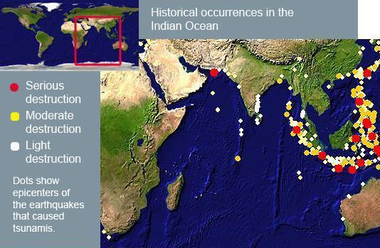
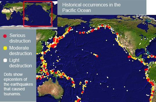
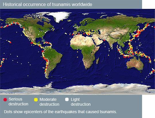
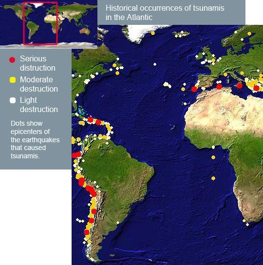
3 Overview Tsunami waves are killer waves radiating from epicenter slammed into the coastline snatching people out to sea. It is a life threatening wave train which will cause severe damage to the population residing at coastal areas. In order to save the life of people, efficient and effective communication mechanism need to be employed to issue warning whenever required Effective communication model to Alert and evacuate general public incase of tsunami Evacuate the population from coastal area by tsunami alert through Handheld Device A web portal has been developed to issue warning for registered users and flash live information on screen Registered device will be tracked to issue warning or alert if the subscriber reaches danger prone area where there is a possibility of tsunami Tsunami impacts over decades No. of occurrence without damage No. of occurrence without damage No. of occurrence with damage
4 Feasibility Study - 4 -


5 Feasibility Study Let s get Digital Digital communities prioritize the interests of people first, providing service designed to meet the needs of people and their communities. The smart things to discover the knowledge about human life, environment interaction, as well as social inter connection and related behaviours To meet the next wave of mobility by proposing rich mobility solution The Digital Solution that will integrate the exceptional circumstances, intelligent infrastructure, sensors, alert systems and people s location and identity. The innovations of devices we use will make our experiences more personalized, context-aware and valuable and with more mobility and location awareness, we are able to gain insights about users and their behaviours to engage them on a personal level - 5 -


6 Proposed Solution Fisherman should be educated to oblige the instructions and alerts to be followed during tsunami. Route map will also be displayed on the device to evacuate towards safer area The small bracelet like solar waterproof device will be tagged on fisherman's hand will be vibrated during the tsunami warning A small light in device stick to all the directions will sparkle and instruct the fisherman to ride their boats towards the route of the light to be followed This device will depict the evacuation plan to move out of the danger zone. This will also help the blind and deft person by simply vibrating if the vibration mode is set on with the alarm. The Tsunami Regional centres across all the coastal areas should be equipped with collection of fisherman data to monitor status in sea - 6 -


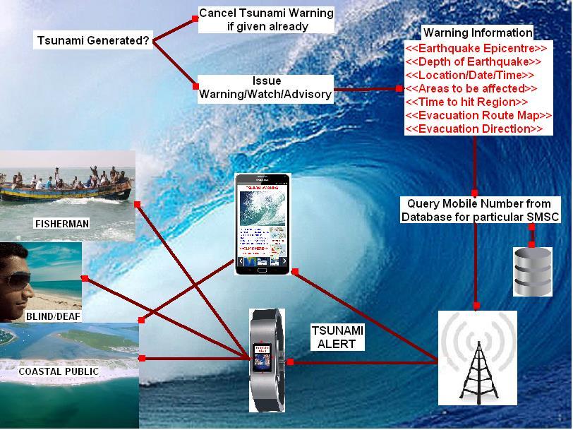
7 Tsunami Alert Bracelet - 7 -

 { Earthquake Location <Area> Magnitude <Richter Scale>")
8 Tsunami Bracelet Evacuation Algorithm Effective Tsunami Warning Evacuation Algorithm( ) { Track the Tsunami warning from Warning Center Spot the Earthquake Hypocenter and trace the location { Date <<Date of Earthquake>> Epicentre <<Place of Underwater Earthquake>> Time <<Time of Earthquake in IST & UST>> Depth <<Depth of Earthquake underwater>> Magnitude << Magnitude in Richter scale>> Latitude <<Latitude of epicentre in degrees>> Longitude << Latitude of epicentre in degrees>> } Scrutinize the contact list based on the area of location Collect the fisherman data from database Identify and send the Warning message to subscribers, Fisherman, blind, deaf and common public While ( Warning Issued = Identified Subscribers) { Earthquake Location <Area> Magnitude <Richter Scale> Date and Time <GMT> Tsunami Message <Warning/Watch/Advisory> Areas to be affected <Region> Tsunami hit Time <IST or UST> Evacuation Route Map <Image> Evacuation Path in Bracelet <GREEN> Prohibited Path in Bracelet <RED> } If ( Acknowledgement = Total Subscribers ) { Warning Issue Successful Evacuation Route map delivery status Periodic watch over Tsunami events If needed, Revoke/Cancel Tsunami Warning } Else { Trace the Subscriber Base Station Try again sending warning Alert Ensure Acknowledgement } Extract the Reports to analyze the delivery status Continuous monitor/watch over the impacted Region Update the site by flash live information frequently Issue warning to other public media for Broadcast } - 8 -


9 Tsunami Alert for Registered Users Subscriber has to register their details to receive the notification/alert service through handheld device In case of any tsunami threat over the coastal region, the alert message will be sent to device stating details about the under water earthquake epicentre along with magnitude, area to be affected with the time approximately. Once the subscriber receives alert message of tsunami warning, they can evacuate from the spot - 9 -


10 Tracing the Mobility of Device
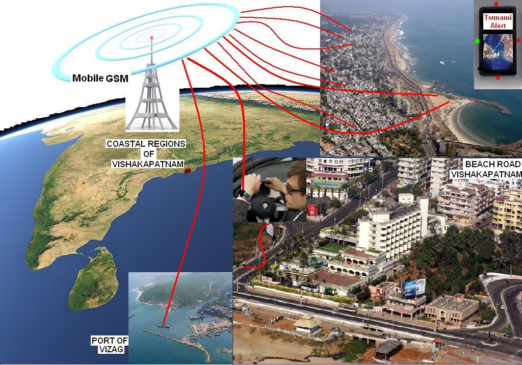

11 Transmission of Alert - Secure

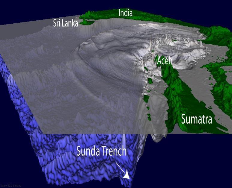

12 Speed of Tsunami

13 Tsunami Travel Time

 Port Blair, Andaman")


14 Tsunami Hit Time Coastal Regions of Bay of Bengal TTT (In Mins) Tsunami Hit Time Time (In IST) Port Blair, Andaman Islands 53 07:21 Colombo, Sri Lanka 96 08:04 Chennai, Tamil Nadu :16 Bhuvaneshwar, Orissa :23 Vizag, Andhra Pradesh 96 08:

15 Integrated Tsunami Warning Portal The web portal has been developed to issue tsunami warning for the registered users who were moving towards the coastal area where the possibilities of tsunami. This site is equipped with live data sources from different regions and information are updated frequently. Live Information will also be flash along with Tsunami warning. 24/7 helpdesk is available to help the general public to know more information related to tsunami impact over the area. Live Data for Earthquake/Tsunami related info and time of hit towards the coastal region Issue Warning or Watch in-case of Tsunami and trace their mobility towards the danger zone Issue warning to Fisherman, blind, deaf and other general public towards tsunami prone zone Evacuation route plan off the coast and safer zone for fisherman at sea Latest information from other Tsunami warning centres across the world and 24/7 help desk for emergency information


16 Live Tsunami Warning Analysis This site has a provision to view the live information from other tsunami warning center across the globe. It also have the history of underwater earth quake details along with magnitude and details of tsunami over the particular region. Admin will be sole moderator for this site and information is updated frequently by 24/7. The main motto is to save the lives, damage or destruction. Since the Bulk SMS are sent through SMPP Protocol, the acknowledgment can also be verified whether the alert message reaches the subscriber. If it failed, the VLR needs to be tracked to locate the subscriber and resend the SMS through particular SMSC. Overall report can also be generated to monitor the status of the alert message either delivered of failed Fisherman location point at mid sea will be determined based on the satellite images or signalling received through their handheld bracelet to predict the time of hit at their respective points. This dynamic time updates help them to plan among them to locate for the safer zone Device should be equipped with local time conversion and also native language conversion for easy understanding Direction of the evacuation would be clearly depicted with the exact Evacuation map where the general public or fisherman need to locate towards the safer zone Fisherman location point at mid sea will be determined based on the satellite images or signaling received through their handheld bracelet to predict the time of hit at their respective points. This dynamic time updates help them to plan among them to locate for the safer zone


17 Enhancements Marine Border Alert Bracelet The Alert should be issued based on fisherman s boat reaches to the longitudinal point towards coastal border of neighbouring nation Fisherman should be educated to oblige the instructions and alerts to be followed in-case nearing IMBL. Route map will also be displayed on the device to evacuate towards Indian Region who are nearing IMBL (International Maritime Border Line) The small bracelet like solar waterproof device will be tagged on fisherman's hand will be vibrated if a fisherman reached towards IMBL. A small light over the device stick to all the directions will be en-lighted and instruct the fisherman to ride their boats towards the route of the light and help them to refrain from getting entered into neighbouring border The device would be programmed in such a way that the speed of the boat is controlled if it reaches towards 1km from IMBL. Further movement towards the IMBL direction would be restricted and engine of the boat switched off to prevent further movement towards neighbouring territory


18 Thank You
International Journal of Advance Engineering and Research Development ADVANCED NAVIGATOR AND MONITORING SYSTEM FOR FISHERMAN
 Scientific Journal of Impact Factor(SJIF): 3.134 International Journal of Advance Engineering and Research Development Volume 3,Issue 3, March -2016 e-issn(o): 2348-4470 p-issn(p): 2348-6406 ADVANCED NAVIGATOR
Computers Watching Tsunamis DEEP- O C E A N A S S E S S M E N T A N D R E P O R T I N G ( D A R T I I )
") Computers Watching Tsunamis DEEP- O C E A N A S S E S S M E N T A N D R E P O R T I N G ( D A R T I I ) Origins of Tsunamis 1 Origins of Tsunamis 1 Energy density I(r) in terms of energy, E, and distance,
Computers Watching Tsunamis DEEP- O C E A N A S S E S S M E N T A N D R E P O R T I N G ( D A R T I I ) Origins of Tsunamis 1 Origins of Tsunamis 1 Energy density I(r) in terms of energy, E, and distance,
SIMULATION OF EARTHQUAKES AND TSUNAMI THROUGH GSM NETWORK
 PROCEEDINGS OF ICETECT 2011 SIMULATION OF EARTHQUAKES AND TSUNAMI THROUGH GSM NETWORK G.SARADHA B.TECH-IT(FINAL YEAR) MOOKAMBIGAI COLLEGE OF ENGINEERING, PUDUKKOTTAI-622 502, TAMILNADU, INDIA. saradhagunasekaran@gmail.com
PADANG. Determination of Hazard from National Level GENERAL INFORMATION
 Determination of Hazard from National Level PADANG Padang with approximately one million citizens is one of the most prawn areas in the world and threatened by possible coming big Earthquakes and Tsunami.
MARITIME BOUNDARY GEO-FENCING WITH ENHANCED ACCURACY. A.M.I. Mihirani, A.W.C.K. Atugoda and D.N. Balasuriya 1
 MARITIME BOUNDARY GEO-FENCING WITH ENHANCED ACCURACY A.M.I. Mihirani, A.W.C.K. Atugoda and D.N. Balasuriya 1 1 Department of Electrical & Computer Engineering, The Open University of Sri Lanka INTRODUCTION
WWNWS 6/3/2/VIII Meeting 6 7 August 2014 Agenda Item 3.2.VIII. MSI Self Assessment NAVAREA VIII. Submitted by India SUMMARY
 WWNWS WWNWS 6/3/2/VIII Meeting 6 7 August 2014 Agenda Item 3.2.VIII MSI Self Assessment NAVAREA VIII Submitted by India SUMMARY Executive Summary: Overview of activities within NAVAREA VIII since WWNWS
Engineering Project Proposals
 Engineering Project Proposals (Wireless sensor networks) Group members Hamdi Roumani Douglas Stamp Patrick Tayao Tyson J Hamilton (cs233017) (cs233199) (cs232039) (cs231144) Contact Information Email:
NAVIGA TIONAL VIGA WARNINGS/MSI/GMDSS N NAV NA AREA III VIII
 NAVIGATIONAL WARNINGS/MSI/GMDSS IN NAVAREA VIII 5/16/2008 1 SCOPE OF PRESENTATION 1. Introduction 2. Navarea VIII Radio Warnings 3. Indian Notices to Mariners 4. Implementation of GMDSS 5. Marine Safety
Regional Tsunami Seminars 2013
 Regional Tsunami Seminars 2013 PROGRAMME 1. Review of Tsunami Hazard in New Zealand 2013 Update: Dr William Power 2. Tsunami warning in New Zealand Process: David Coetzee; Dr Ken Gledhill 3. Sirens standard
There are not any on site emergency medical facilities in Holberg.
 12.2 HOLBERG Holberg is located on Holberg Inlet which has access to the Pacific Ocean on the west coast of Vancouver Island. Population is approximately 70 persons with the village located mainly at the
WWNWS6/3/2/XVI Meeting 6 30 July 2014 Agenda Item 3.2.XVI. MSI Self Assessment NAVAREA XVI. Submitted by
 WWNWS WWNWS6/3/2/XVI Meeting 6 30 July 2014 Agenda Item 3.2.XVI MSI Self Assessment NAVAREA XVI Submitted by PERÚ - DIRECTORATE OF HYDROGRAPHY AND NAVIGATION SUMMARY Executive Summary: THIS DOCUMENT REPORTS
Royal Canadian Mounted Police Port Hardy Detachment There are no on-site emergency medical facilities in Holberg.
 PART 4.3 HOLBERG 4.3.1 Overview Holberg is located on Holberg Inlet which has access to the Pacific Ocean on the west coast of Vancouver Island. Population is approximately 100 persons, with the village
Emergency Information Broadcasting Distribution System
 Safety Earthquake Early Warning Broadcasting Distribution Function Emergency Information Broadcasting Distribution System Systems for broad and general emergency distribution of earthquake early warnings
(P.27)
") (P.27) 27 7 210 120 8 * Navigation and Anchoring Prohibited Area has been changed since June, 2017. 9 Port of Osaka The Guidelines of Measures for preventing Typhoon Disaster ( Objective )
(P.27) 27 7 210 120 8 * Navigation and Anchoring Prohibited Area has been changed since June, 2017. 9 Port of Osaka The Guidelines of Measures for preventing Typhoon Disaster ( Objective )
Agenda. The disaster cycle. Elements of a community-based warning system*
 Elements of a community-based system* * and its relation to a public system Rohan Samarajiva Presentation at Workshop on Sharing Knowledge 5 March 2008, Jakarta Agenda The disaster cycle and the role of
Second explosion at Japan nuclear plant
 www.breaking News English.com Ready-to-use ESL/EFL Lessons by Sean Banville 1,000 IDEAS & ACTIVITIES FOR LANGUAGE TEACHERS The Breaking News English.com Resource Book http://www.breakingnewsenglish.com/book.html
Juan GAVIRIA, Sector Leader AFTTR
 Earth Observation in support of the Western Indian Ocean Marine Highway Development and Coastal and Marine Contamination Prevention Project - Oil spill detection & Coral reef monitoring Juan GAVIRIA, Sector
Western Indian Ocean Marine Highway Development and Coastal and Marine Contamination Prevention Project - Oil spill detection & Coral reef monitoring
 Earth Observation in support of the Western Indian Ocean Marine Highway Development and Coastal and Marine Contamination Prevention Project - Oil spill detection & Coral reef monitoring Juan GAVIRIA, Sector
Intelligent Bus Tracking and Implementation in FPGA
 Intelligent Bus Tracking and Implementation in FPGA D.Gowtham 1,M.Deepan 1,N.Mohamad Arsathdeen 1,N.Mithun Mano Ranjith 1,Mrs.A.K.Kavitha 2 1.B.E(student) Final year, Electronics and Communication Engineering
New Approach for Tsunami Detection Based on RTK-GNSS Using Network of Ships
 New Approach for Tsunami Detection Based on RTK-GNSS Using Network of Ships Tokyo University of Marine Science and Technology Ryuta Nakaosone Nobuaki Kubo Background After the Indian Ocean Tsunami on 2004,
Development and performance assessment of a hybrid telemetry system for Indian tsunami buoy system
 doi:10.3723/ut.33.105 Underwater Technology, Vol. 33, No. 2, pp. 105 113, 2015 www.sut.org Development and performance assessment of a hybrid telemetry system for Indian tsunami buoy system Technical Paper
Guy FREMONT Innovative Solutions Manager
 1 Cooperative Systems: how can community networks improve road safety? Guy FREMONT Innovative Solutions Manager The Sanef Group o Concessionaire of 2 toll networks, representing 1757 km in operation: Sanef:
Advanced Warning Message Distribution Platform for the Next-generation Mobile Communication Network
 SAE Emergency Warning System Area Mail Special Articles on SAE Standardization Technology Advanced Warning Message Distribution Platform for the Next-generation Mobile Communication Network 3GPP Release
28th Seismic Research Review: Ground-Based Nuclear Explosion Monitoring Technologies SEL0: A FAST PROTOTYPE BULLETIN PRODUCTION PIPELINE AT THE CTBTO
 SEL0: A FAST PROTOTYPE BULLETIN PRODUCTION PIPELINE AT THE CTBTO Ronan J. Le Bras 1, Tim Hampton 1, John Coyne 1, and Alexander Boresch 2 Provisional Technical Secretariat of the Preparatory Commission
PUBLIC ALERT: Delivers Emergency All-Hazard Warnings, Everywhere, All the Time
 PUBLIC ALERT: Delivers Emergency All-Hazard Warnings, Everywhere, All the Time DELIVERS EMERGENCY ALL-HAZARD WARNINGS In November 2002, the National Oceanic and Atmospheric Administration (NOAA) and National
GPS BASED SHIP MONITORING AND CONTROLLING SYSTEM USING ZIGBEE
 GPS BASED SHIP MONITORING AND CONTROLLING SYSTEM USING ZIGBEE G. Muthurajan 1, L. Jeyanthi 2 1 ECE, Periyar Maniammai Univerisity 2 Assistant Professor, ECE, Periyar Maniammai Univerisity Abstract The
Port Security and Technology - the U.S. Perspective. Michael S. Bruno Stevens Institute of Technology March 14, 2012
 Port Security and Technology - the U.S. Perspective Michael S. Bruno Stevens Institute of Technology March 14, 2012 CSR A Department of Homeland Security National Center of Excellence for Port Security
DAB EWF Emergency Warning & Alert Functionality
 DAB EWF Emergency Warning & Alert Functionality DAB Tools, Features and Considerations 2014-06-14 DAB Workshop @ itvf, Istanbul Dipl.-Ing. Bernd Linz Fraunhofer IIS Broadcast Applications bernd.linz@iis.fraunhofer.de
MARITIME SAFETY INFORMATION
 Introduction 1. Maritime Safety Information (MSI) is defined as navigational and meteorological warnings, meteorological forecasts, and other urgent safety-related messages. This information is of vital
IoT Based Border Alert and Secured System for Fisherman
 429 IoT Based Border Alert and Secured System for Fisherman Uthayakumar Jothilingam 1, Liston Deva Glindis 2 1 M.E. Student, Dept. of Computer Science Engg., Dhanalakshmi Srinivasan College of Engg., Coimbatore,
HarborGuard-Pro. Integrated Maritime Security & Surveillance System
 HarborGuard-Pro Integrated Maritime Security & Surveillance System Klein Marine Systems, Inc. 11 Klein Drive, Salem, NH, USA 03079 Web: www.kleinmarinesystems.com This technical data and software is considered
SOUTH AFRICAN NAVY HYDROGRAPHIC OFFICE
 SOUTH AFRICAN NAVY HYDROGRAPHIC OFFICE GLOSS National Report for South Africa 2009 Compiled by Ms Ruth Farre Superintendent Tidal Information 1. Introduction The South African coastline is approximately
An Automated Rainfall Monitoring System
 ENGINEER - Vol. XXXIX, No. 02, pp. 53-58,2006 The Institution of Engineers, Sri Lanka The following paper received... An Automated Rainfall Monitoring System S.P.K.A Gunawardena, B.M.D Rangana & M.M Siriwardena
Novel Wireless Weather Data Communication for Fishermen
 Available Online at www.ijcsmc.com International Journal of Computer Science and Mobile Computing A Monthly Journal of Computer Science and Information Technology ISSN 2320 088X IMPACT FACTOR: 5.258 IJCSMC,
A Study on Earthquake Detection Using Machine Learning
 A Study on Earthquake Detection Using Machine Learning 1 2 N. NIRMALAP P, K. REKHAP 1 PG-StudentP P, Assistant ProfessorP P, Department Of Computer Science, Jeppiaar Engineering College, Chennai-119. 2
NC Models. CP390i - GPS Chart Plotters. Addendum to Owner s Manual Issue C to update to Software Version (*)
") CP390i - GPS Chart Plotters (*) NC Models to Owner s Manual Issue 16.50 C 300311 to update to Software Version 16.70 BUILT-IN CHARTS ARE NOT INSTALLED The following paragraphs/pictures are not applicable:
CP390i - GPS Chart Plotters (*) NC Models to Owner s Manual Issue 16.50 C 300311 to update to Software Version 16.70 BUILT-IN CHARTS ARE NOT INSTALLED The following paragraphs/pictures are not applicable:
Addressable Radios for Emergency Alert (AREA): WorldSpace Satellite Radio
: WorldSpace Satellite Radio") Addressable Radios for Emergency Alert (AREA): A WorldSpace solution for effective delivery of alerts S.Rangarajan, Jerome Soumagne and Jean-Luc Vignaud WorldSpace Satellite Radio srangarajan@worldspace.com,
Addressable Radios for Emergency Alert (AREA): A WorldSpace solution for effective delivery of alerts S.Rangarajan, Jerome Soumagne and Jean-Luc Vignaud WorldSpace Satellite Radio srangarajan@worldspace.com,
Safety System For Fishing Boats To Prevent From International Border Crossing
 Safety System For Fishing Boats To Prevent From International Border Crossing Vijayakumar.T 1, Jagadesan.D 2, Prasad.M 3, Prabin.S.B 4,Ramu.S 5 1,2,3,4 Final Year BE Mechatronics, PPG Institute of Technology,
Intelligent Accident Detection System
 GRD Journals Global Research and Development Journal for Engineering National Conference on Emerging Research Trend in Electrical and Electronics Engineering (ERTEE-2018) March 2018 e-issn: 2455-5703 Intelligent
1.Earthquake Early Warning System. Japan Meteorological Agency
 1 st Process 1.Earthquake Early Warning System Estimation Estimation of of Hypocenter, Hypocenter, Magnitude Magnitude and and Seismic Seismic Intensity Intensity Dissemination Dissemination 2. 2. Present
CASMB ENVIS Estuaries, Mangroves, Coral Reefs & Lagoons. Major achievements of CASMB ENVIS Centre ( )
") CASMB ENVIS Estuaries, Mangroves, Coral Reefs & Lagoons Major achievements of CASMB ENVIS Centre (2011-2016) Annamalai University Centre of Advanced Study in Marine Biology Publications 1. Newsletters
CASMB ENVIS Estuaries, Mangroves, Coral Reefs & Lagoons Major achievements of CASMB ENVIS Centre (2011-2016) Annamalai University Centre of Advanced Study in Marine Biology Publications 1. Newsletters
LPWA: Enabling Extreme Wildlife Tracking
 LPWA: Enabling Extreme Wildlife Tracking Mobile IoT = TRUSTED IoT Table of Contents Summary 2 Connectivity for wildlife conservation 2 3 Saving Harbour Seals 3 4 The Imminent Expansion of the Internet
MINIMIZING DELAYS IN SEARCH AND RESCUE RESPONSE TO DISTRESS ALERTS
 INTERNATIONAL MARITIME ORGANIZATION 4 ALBERT EMBANKMENT LONDON SE1 7SR Telephone: 020 7735 7611 Fax: 020 7587 3210 IMO E Ref. T2-OSS/1.4 MSC.1/Circ.1248 16 October 2007 MINIMIZING DELAYS IN SEARCH AND
RESOLUTION MSC.278(85) (adopted on 1 December 2008) ADOPTION OF THE NEW MANDATORY SHIP REPORTING SYSTEM "OFF THE COAST OF PORTUGAL - COPREP"
 (adopted on 1 December 2008) ADOPTION OF THE NEW MANDATORY SHIP REPORTING SYSTEM OFF THE COAST OF PORTUGAL - COPREP") MSC 85/26/Add.1 RESOLUTION MSC.278(85) SYSTEM OFF THE COAST OF PORTUGAL COPREP THE MARITIME SAFETY COMMITTEE, RECALLING Article 28 of the Convention on the International Maritime Organization concerning
MSC 85/26/Add.1 RESOLUTION MSC.278(85) SYSTEM OFF THE COAST OF PORTUGAL COPREP THE MARITIME SAFETY COMMITTEE, RECALLING Article 28 of the Convention on the International Maritime Organization concerning
J.K. Patterson Edward
 Seagrass and Dugong Conservation in Gulf of Mannar and Palk Bay region in Tamil Nadu, South-eastern India - Status, Conservation Initiatives and Challenges J.K. Patterson Edward Suganthi Devadason Marine
SAFETY EQUIPMENT AND PREPARATION. S/V Odette USA 5619
 SAFETY EQUIPMENT AND PREPARATION S/V Odette USA 5619 Odette5619@gmail.com COMMUNICATION PREPARATION Dedicate dock time for crew to familiarize themselves with all communication equipment: VHF: Walk through
Stabilization of the Mobility in Free Traffic
 Indian Journal of Science and Technology, Vol 9(31), DOI: 10.17485/ijst/2016/v9i31/98122, August 2016 ISSN (Print) : 0974-6846 ISSN (Online) : 0974-5645 Stabilization of the Mobility in Free Traffic A.
DELAWARE COUNTY PUBLIC WARNING SYSTEM
 Appendix III-3 DELAWARE COUNTY PUBLIC WARNING SYSTEM Appendix III- 3-1 EMERGENCY ALERT SYSTEM (EAS) PLAN FOR DELAWARE COUNTY, NEW YORK PURPOSE 1. To meet Federal guidelines set down for a plan by each
This circular summarizes the various important aspects of the LRIT system with a view to enabling companies to ensure compliance in a timely manner.
 Luxembourg, 29/10/2008 CIRCULAR CAM 02/2008 N/Réf. : AH/63353 Subject : Long-Range Identification and Tracking of Ships (LRIT) To : All ship owners, ship operators and designated persons of Luxembourg
KEYWORDS Earthquakes; MEMS seismic stations; trigger data; warning time delays. Page 144
 Event Detection Time Delays from Community Earthquake Early Warning System Experimental Seismic Stations implemented in South Western Tanzania Between August 2012 and December 2013 Asinta Manyele 1, Alfred
TCAS Functioning and Enhancements
 TCAS Functioning and Enhancements Sathyan Murugan SASTRA University Tirumalaisamudram, Thanjavur - 613 402. Tamil Nadu, India. Aniruth A.Oblah KLN College of Engineering Pottapalayam 630611, Sivagangai
International Journal of Advance Engineering and Research Development DESIGN OF SHIP ROUTE TRACKING AND ALERT SYSTEM BY USING SATELLITE PHONE
 Scientific Journal of Impact Factor (SJIF): 5.71 International Journal of Advance Engineering and Research Development Volume 5, Issue 02, February -2018 e-issn (O): 2348-4470 p-issn (P): 2348-6406 DESIGN
Technical Requirements for Wireless Broadband Services (WBS) in the Band MHz
 in the Band MHz") Issue 2 June 2010 Spectrum Management and Telecommunications Standard Radio System Plan Technical Requirements for Wireless Broadband Services (WBS) in the Band 3650-3700 MHz Aussi disponible en français
Issue 2 June 2010 Spectrum Management and Telecommunications Standard Radio System Plan Technical Requirements for Wireless Broadband Services (WBS) in the Band 3650-3700 MHz Aussi disponible en français
ISTANBUL EARTHQUAKE RAPID RESPONSE AND THE EARLY WARNING SYSTEM. M. Erdik Department of Earthquake Engineering aziçi University,, Istanbul
 ISTANBUL EARTHQUAKE RAPID RESPONSE AND THE EARLY WARNING SYSTEM M. Erdik Department of Earthquake Engineering Boğazi aziçi University,, Istanbul ISTANBUL THREATENED BY MAIN MARMARA FAULT ROBABILITY OF
Question 1: Do you have any comments on our approach to this review?:
 Question 1: Do you have any comments on our approach to this review?: Iridium supports Ofcom to take a long-term strategic approach to spectrum planning for space services. As operator of a global satellite
November 23 rd, 2018 Sample Current Affairs
 November 23 rd, 2018 Sample Current Affairs 1. Government of India decided to save the 20 wetlands as they are congregation sites for several migratory water bird species. What is Central Asian Flyway?
Meeting 10 8 August 2018 Agenda Item 2.1. MSI Self Assessment NAVAREA XVI. Submitted by PERÚ - DIRECTORATE OF HYDROGRAPHY AND NAVIGATION SUMMARY
 WWNWS10 WWNWS10/2/1-XVI Meeting 10 8 August 2018 Agenda Item 2.1 MSI Self Assessment NAVAREA XVI Submitted by PERÚ - DIRECTORATE OF HYDROGRAPHY AND NAVIGATION SUMMARY Executive Summary: Report of activities
Development of Tsunami early warning embedded system with GSM alert
 2 nd International Conference on Current Research Trends in Engineering and Technology 2018 IJSRSET Volume 4 Issue 5 Print ISSN: 2395-1990 Online ISSN : 2394-4099 Themed Section: Engineering and Technology
Use of Satellite Remote Sensing in Tsunami Damage Assessment
 Japan-Peru Workshop on Earthquake Disaster Mitigation, Lima 2005 Use of Satellite Remote Sensing in Tsunami Damage Assessment August 10, 2005 Fumio Yamazaki Chiba University, Chiba, Japan 1 World Tsunami
Earthquake Early Warning System (EEWS) *Saba S D 1,Manasa S N,Shruthi B T 3, Sneha vardhi 4
 *Saba S D 1,Manasa S N,Shruthi B T 3, Sneha vardhi 4") Earthquake Early Warning System (EEWS) *Saba S D 1,Manasa S N,Shruthi B T 3, Sneha vardhi 4 1,2,3,4 Sambhram Institute of Technology M S palya, Jalahalli East, Vidyaranyapura, Bengaluru, Karnataka 560091
Earthquake Early Warning System (EEWS) *Saba S D 1,Manasa S N,Shruthi B T 3, Sneha vardhi 4 1,2,3,4 Sambhram Institute of Technology M S palya, Jalahalli East, Vidyaranyapura, Bengaluru, Karnataka 560091
GNSS (GPS) buoy array in the Pacific for natural disaster mitigation. Teruyuki KATO Earthquake Research Institute the University of Tokyo, Japan
 buoy array in the Pacific for natural disaster mitigation. Teruyuki KATO Earthquake Research Institute the University of Tokyo, Japan") GNSS (GPS) buoy array in the Pacific for natural disaster mitigation Teruyuki KATO Earthquake Research Institute the University of Tokyo, Japan 1 (Modified from Oki & Koketsu, 2011) Historical megaquakes
GNSS (GPS) buoy array in the Pacific for natural disaster mitigation Teruyuki KATO Earthquake Research Institute the University of Tokyo, Japan 1 (Modified from Oki & Koketsu, 2011) Historical megaquakes
Myanmar Naval Hydrographic Centre. National Report for 13 th North Indian Ocean Hydrographic Commission Meeting
 Myanmar Naval Hydrographic Centre National Report for 13 th North Indian Ocean Hydrographic Commission Meeting Yangon, Myanmar 19 th 22 nd February 2013 CONTENT 1. Myanmar Naval Hydrographic Centre 2.
IMO/IHO World-wide Navigational Warning Service (WWNWS)
") IMO/IHO World-wide Navigational Warning Service (WWNWS) 1 WWNWS 1972 PROPOSAL TO SET UP AN Ad Hoc IHO/IMO COMMITTEE TO DEVELOP AN INTER- NATIONALLY CO-ORDINATED SYSTEM FOR PROMULGATING LONG RANGE NAVIGATIONAL
IMO/IHO World-wide Navigational Warning Service (WWNWS) 1 WWNWS 1972 PROPOSAL TO SET UP AN Ad Hoc IHO/IMO COMMITTEE TO DEVELOP AN INTER- NATIONALLY CO-ORDINATED SYSTEM FOR PROMULGATING LONG RANGE NAVIGATIONAL
Accident prevention and detection using internet of Things (IOT)
") ISSN:2348-2079 Volume-6 Issue-1 International Journal of Intellectual Advancements and Research in Engineering Computations Accident prevention and detection using internet of Things (IOT) INSTITUTE OF
ISSN:2348-2079 Volume-6 Issue-1 International Journal of Intellectual Advancements and Research in Engineering Computations Accident prevention and detection using internet of Things (IOT) INSTITUTE OF
AN OVERVIEW OF THE STATE OF MARINE SPATIAL PLANNING IN THE MEDITERRANEAN COUNTRIES MALTA REPORT
 AN OVERVIEW OF THE STATE OF MARINE SPATIAL PLANNING IN THE MEDITERRANEAN COUNTRIES MALTA REPORT Malta Environment & Planning Authority May 2007 AN OVERVIEW OF THE STATE OF MARINE SPATIAL PLANNING IN THE
It s Easy Know your tsunami zone
 Kapiti It s Easy Know your tsunami zone Porirua Hutt Valley Castlepoint Wellington City Lake Onoke Riversdale Beach Ngawi A tsunami is a series of sea waves or surges caused by a sudden event (such as
Tsunami Detection System Nick Street, Project Engineer David Mould, Presenter.
 Tsunami Detection System Nick Street, Project Engineer David Mould, Presenter Agenda 1. Need for Tsunami Detection System 2. System Overview 3. Tsunami Detection System requirements 4. Seabed Unit - Tsunameter
Smart Blind Help ABSTRACT I. INTRODUCTION II. LITERATURE SURVEY
 International Journal of Scientific Research in Computer Science, Engineering and Information Technology Smart Blind Help 2018 IJSRCSEIT Volume 3 Issue 3 ISSN : 2456-3307 Rohan Parte, Omkar Ghenand, Akshay
International Journal of Scientific & Engineering Research Volume 8, Issue 7, July-2017 ISSN
 243 AUTOMATIC SPEED CONTROL OF VEHICLES IN SPEED LIMIT ZONES USING RF AND GSM Mrs.S.Saranya M.E., Assistant Professor Department of Electronics and Communication engineering Sri Ramakrishna Engineering
IMO RESOLUTION A.1001(25) Adopted on 29 November 2007 (Agenda item 9)
 Adopted on 29 November 2007 (Agenda item 9)") INTERNATIONAL MARITIME ORGANIZATION E IMO ASSEMBLY 25th session Agenda item 9 A 25/Res.1001 3 January 2008 Original: ENGLISH RESOLUTION A.1001(25) Adopted on 29 November 2007 (Agenda item 9) CRITERIA FOR
INTERNATIONAL MARITIME ORGANIZATION E IMO ASSEMBLY 25th session Agenda item 9 A 25/Res.1001 3 January 2008 Original: ENGLISH RESOLUTION A.1001(25) Adopted on 29 November 2007 (Agenda item 9) CRITERIA FOR
Coastal Surveillance. SCANTER Radar Solutions
 Coastal Surveillance SCANTER Radar Solutions Protecting Your Coastlines and Maritime Domain We provide radar coverage of the coastline to detect and track all types of surface vessels and air targets.
Information. Potential Civil and Scientific Applications of the CTBT Verification Technologies Page 1. Contributing to tsunami warning
 Information Potential civil and scientific applications of the CTBT verification technologies The CTBTO global network of 337 facilities monitors the planet for possible nuclear explosions. Scientific
Azaad Kumar Bahadur 1, Nishant Tripathi 2
 e-issn 2455 1392 Volume 2 Issue 8, August 2016 pp. 29 35 Scientific Journal Impact Factor : 3.468 http://www.ijcter.com Design of Smart Voice Guiding and Location Indicator System for Visually Impaired
XV. MITRE Corporation
 XV. MITRE Corporation A. General Information The MITRE Corporation, established in 1958, is a not-for-profit organization which conducts work in systems engineering, information technology, operational
A Sensor Network Based Real Time Flood Warning System
 A Sensor Network Based Real Time Flood Warning System Final Report Project Period: 12/12/08 6/30/2010 PI: Soon Ae Chun College of Staten Island, City University of New York 1. Ocean Surge based Flood Warning
Determination of tsunami sources using deep ocean wave records
 Bull. Nov. Comp. Center, Math. Model. in Geoph., 11 (26), 53 63 c 26 NCC Publisher Determination of tsunami sources using deep ocean wave records A.Yu. Bezhaev, M.M. Lavrentiev (jr.), An.G. Marchuk, V.V.
A n I n t e g r a t e d S y s t e m f o r w a v e m o n i t o r i n g a n d s m a l l a n d s l o w t a r g e t s d e t e c t i o n
 A n I n t e g r a t e d S y s t e m f o r w a v e m o n i t o r i n g a n d s m a l l a n d s l o w t a r g e t s d e t e c t i o n Remocean S.p.A. P.IVA e C.F.: 06730281216 - Numero REA: NA - 835413 Registered
Targeting a Safer World
 Targeting a Safer World INTRODUCTION Accipiter Radar is a global provider of high performance radar surveillance solutions built upon its patented Radar Intelligence Network (RIN) Platform Technology.
GPS TECHNOLOGY IN COMMUNITY SERVICES
 Abstract ISSN: 2456-2955 GPS TECHNOLOGY IN COMMUNITY SERVICES James Anderson Computer Department, Maseno University jamesbynature@gmail.com The paper demonstrated the role of GPS technology in law enforcement
Accident Sensor with Google Map Locator
 IJIRST International Journal for Innovative Research in Science & Technology Volume 2 Issue 10 March 2016 ISSN (online): 2349-6010 Accident Sensor with Google Map Locator Steffie Tom Keval Velip Aparna
WWNWS9/3/2/XVI/Rev.1 Meeting 9 22 August 2017 Agenda Item 3.2. MSI Self Assessment NAVAREA XVI. Submitted by
 WWNWS9 WWNWS9/3/2/XVI/Rev.1 Meeting 9 22 August 2017 Agenda Item 3.2 MSI Self Assessment NAVAREA XVI Submitted by PERÚ - DIRECTORATE OF HYDROGRAPHY AND NAVIGATION SUMMARY Executive Summary: Report of activities
UCS-805 MOBILE COMPUTING NIT Agartala, Dept of CSE Jan-May,2011
 Location Management for Mobile Cellular Systems SLIDE #3 UCS-805 MOBILE COMPUTING NIT Agartala, Dept of CSE Jan-May,2011 ALAK ROY. Assistant Professor Dept. of CSE NIT Agartala Email-alakroy.nerist@gmail.com
Turks and Caicos Islands Table of Frequency Allocations 88 MHz to 59 GHz
 Turks and Caicos Islands Table of Frequency Allocations 88 MHz to 59 GHz Published March 21, 2011 (Incorporating the Decisions of the 2007 World Radiocommunication Conference) 1 The Turks and Caicos Islands
Our Quality Promise WHITE PAPER
 Our Quality Promise www.digitalglobe.com Corporate (U.S.) +1.303.684.4561 or +1.800.496.1225 London +44.20.8899.6801 Singapore +65.6389.4851 To ensure your success, we put quality at our core At DigitalGlobe,
Sir Arthur C. Clarke, Colombo, Sri Lanka
 Sir Arthur C. Clarke, Colombo, Sri Lanka By Shabidul Alam, National Geographic Space images received from the European Space Agency (ESA) Audio greeting to the global launch event of International Year
Location of assessment:
 INITIAL RAPID ASSESSMENT COMMUNITY ENGAGEMENT AND ACCOUNTABILITY SULAWESI EARTHQUAKE AND TSUNAMI 10 October, 2018 Initial Rapid Assessment CEA Sulawesi Earthquake and Tsunami Page 2 EARTHQUAKE AND TSUNAMI
MURS New Wireless Technology for Text & Location Share without Cellular Signal to P2P
 I J C T A, 9(9), 2016, pp. 3959-3963 International Science Press MURS New Wireless Technology for Text & Location Share without Cellular Signal to P2P C. Bala Saravanan 1, R. Rrabu 2 and L. Gladis Flower
«INTRARADAR» Port of Corfu
 «INTRARADAR» Port of Corfu INTERREG IIIA Greece-Italy IMPETUS was the contractor of the Prefecture of Corfu for the INTRARADAR project. The project focused on the provision, installation of hardware/software
OPERATIONS SEAFARER CERTIFICATION GUIDANCE NOTE SA MARITIME QUALIFICATIONS CODE SHORT RANGE CERTIFICATE (SRC)
") Page 1 of 8 Compiled by Chief Examiner Approved by Senior Radio Examiner OPERATIONS SEAFARER CERTIFICATION GUIDANCE NOTE SA MARITIME QUALIFICATIONS CODE SHORT Page 2 of 8 SHORT : OUTLINE EXAMINATION SYLLABUS
Page 1 of 8 Compiled by Chief Examiner Approved by Senior Radio Examiner OPERATIONS SEAFARER CERTIFICATION GUIDANCE NOTE SA MARITIME QUALIFICATIONS CODE SHORT Page 2 of 8 SHORT : OUTLINE EXAMINATION SYLLABUS
Proposed Anchorage Grounds, Hudson River; Yonkers, NY to Kingston, NY Docket Number USCG
 August 8, 2016 U.S. Coast Guard First District C/O Mr. Craig Lapiejko Waterways Management Branch Submitted Via Federal erulemaking Portal Subject: Proposed Anchorage Grounds, Hudson River; Yonkers, NY
BOAT LOCALIZATION AND WARNING SYSTEM FOR BORDER IDENTIFICATION
 BOAT LOCALIZATION AND WARNING SYSTEM FOR BORDER IDENTIFICATION Mr.Vasudevan, Ms.Aarthi.C, Ms.Arunthathi.M, Ms.Durgakalaimathi.L.T, Ms.Evangelin Darvia.P 1Professor, Dept. of ECE, Panimalar Engineering
INTERNATIONAL STANDARD
 INTERNATIONAL STANDARD IEC 61174 Edition 4.0 2015-08 colour inside Maritime navigation and radiocommunication equipment and systems Electronic chart display and information system (ECDIS) Operational and
Roberts Bank Terminal 2 Project Field Studies Information Sheet
 May 2013 Port Metro Vancouver is continuing field studies in May as part of ongoing environmental and technical work for the proposed Roberts Bank Terminal 2 Project. Roberts Bank Terminal 2 Project The
Frank Heymann 1.
 Plausibility analysis of navigation related AIS parameter based on time series Frank Heymann 1 1 Deutsches Zentrum für Luft und Raumfahrt ev, Neustrelitz, Germany email: frank.heymann@dlr.de In this paper
All IMO Member States Intergovernmental organizations Non-governmental organizations in consultative status with IMO
 E 4 ALBERT EMBANKMENT LONDON SE1 7SR Telephone: +44 (0)20 7735 7611 Fax: +44 (0)20 7587 3210 9 May 2018 To: Subject: All IMO Member States Intergovernmental organizations Non-governmental organizations
14 February 2011 Japan
 Concerning to the ToR on the Long-Term Sustainability of Outer Space Activities of the STSC (A/AC.105/C.1/L.307) Procedure for Risk Assessment & Identification of Best Practices to Support the WG for Sustainability
KNOWLEDGE NOTE 5-3. Risk Communication. CLUSTER 5: Hazard and Risk Information and Decision Making. Risk Communication
 KNOWLEDGE NOTE 5-3 CLUSTER 5: Hazard and Risk Information and Decision Making 1 Prepared by Rajib Shaw, Yukiko Takeuchi, and Shohei Matsuura, Kyoto University; and Keiko Saito, World Bank 2 KNOWLEDGE NOTE
CS 621 Mobile Computing
 Lecture 11 CS 621 Mobile Computing Location Management for Mobile Cellular Systems Zubin Bhuyan, Department of CSE, Tezpur University http://www.tezu.ernet.in/~zubin Several slides and images in this presentation
RESOLUTION MSC.233(82) (adopted on 5 December 2006) ADOPTION OF THE PERFORMANCE STANDARDS FOR SHIPBORNE GALILEO RECEIVER EQUIPMENT
 (adopted on 5 December 2006) ADOPTION OF THE PERFORMANCE STANDARDS FOR SHIPBORNE GALILEO RECEIVER EQUIPMENT") MSC 82/24/Add.2 RESOLUTION MSC.233(82) THE MARITIME SAFETY COMMITTEE, RECALLING Article 28(b) of the Convention on the International Maritime Organization concerning the functions of the Committee, RECALLING
MSC 82/24/Add.2 RESOLUTION MSC.233(82) THE MARITIME SAFETY COMMITTEE, RECALLING Article 28(b) of the Convention on the International Maritime Organization concerning the functions of the Committee, RECALLING
Installation and connection of Galileosky v4.0 tracking devices
 Installation and connection of Galileosky v4.0 tracking devices User Manual www.galileosky.com Contents Necessary Tools, Devices, Materials... 3 General Information... 4 Galileosky v4.0 Tracking Device