RAILROAD COMMISSION OF TEXAS OIL & GAS DIVISION
|
|
|
- June Heath
- 5 years ago
- Views:
Transcription
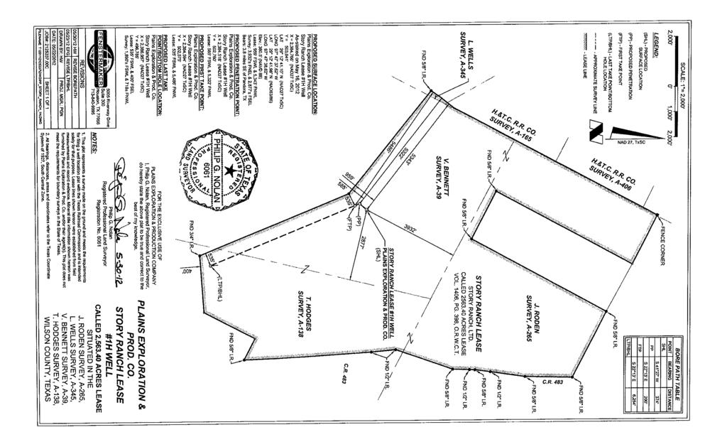
1 API No Drilling Permit # SWR Exception Case/Docket No. 4. Lease Name GENERAL INFORMATION 6. Purpose of filing (mark ALL appropriate boxes): 1. RRC Operator No. 2. Operator's Name (as shown on form P-5, Organization Report) 3. Operator Address (include street, city, state, zip): 5. Well No. X New Drill Recompletion Reclass Field Transfer Re-Enter Amended 1H Amended as Drilled (BHL) (Also File Form W-1D) FORM W-1 07/ Wellbore Profile (mark ALL appropriate boxes): X Vertical X Horizontal (Also File Form W-1H) Directional (Also File Form W-1D) Sidetrack 8. Total Depth 9. Do you have the right to develop the minerals under any right-of-way? X Yes No 10. Is this well subject to Statewide Rule 36 (hydrogen sulfide area)? X SURFACE LOCATION AND ACREAGE INFORMATION 11. RRC District No. 12. County 01 WILSON 13. Surface Location X Land Bay/Estuary Inland Waterway 14. This well is to be located 3.8 miles in a SE direction from PANDORA which is the nearest town in the county of the well site. 15. Section 16. Block 17. Survey BENNETT, V 18. Abstract No. A Distance to nearest lease : 400 ft. 21. Lease Perpendiculars: 959 ft from the SW and 5343 ft from the NW. 22. Survey Perpendiculars: 3932 ft from the NE and 2877 ft from the SE. 23. Is this a pooled unit? Yes X No 24. Unitization Docket No: 25. Are you applying for Substandard Acreage Field? Yes (attach Form W-1A) X No Yes Offshore No 20. Number of contiguous acres in lease, pooled unit, or unitized tract: FIELD INFORMATION List all fields of anticipated completion including Wildcat. List one zone per. 26. RRC District No. 27. Field No. 28. Field Name (exactly as shown in RRC records) 29. Well Type 30. Completion Depth 31. Distance to Nearest Well in this Reservoir 32. Number of Wells on this lease in this Reservoir EAGLEVILLE (EAGLE FORD-1) Oil or Gas Well < see Page 2 for additional Fields > BOTTOMHOLE LOCATION INFORMATION is required for DIRECTIONAL, HORIZONTAL, AND AMENDED AS DRILLED PERMIT APPLICATIONS Remarks [FILER May 30, :53 PM]: Vertical pilot hole drilled as a Wildcat to a depth of 13550'.Vertical plat attached. (see W-1H attachment) Certificate: I certify that information stated in this application is true and complete, to the best of my knowledge. RRC Use Only Data Validation Time Stamp: Jun 8, :39 PM( 'As ' Version ) Page 1 of 3 Donnie Stowe, Permit Specialist Name of filer (713) Phone May 30, 2012 Date submitted dstowe@pxp.com Address (OPTIONAL)
2 The RRC has not approved this application. Duplication or distribution of information is at the user's own risk. W-1 Supplemental Field Data 07/2004 Permit # Date: Jun 08, RRC Operator No. 2. Operator's Name (exactly as shown on form P-5, Organization Report) 3. Lease Name 4. County WILSON ADDITIONAL FIELD INFORMATION ( continued from Page 1 ) 26. RRC District No. 27. Field No. 28. Field Name (exactly as shown in RRC records) 29. Well Type 30. Completion Depth 31. Distance to Nearest Well in this Reservoir 32. Number of Wells on this lease in this Reservoir 33. Total Acres WILDCAT Oil or Gas Well Lease Name & Well Number, Well No. 1 Surface Lease/Unit Perpendiculars 959 ft from SW ; 5343 ft from NW Wellbore Profiles Vertical Page 2 of 3
3 The RRC has not approved this application. Duplication or distribution of information is at the user's own risk. Form W-1H 07/2004 Supplemental Horizontal Well Information Permit # Date: Jun 08, RRC Operator No. 2. Operator's Name (exactly as shown on form P-5, Organization Report) 3. Lease Name Lateral Drainhole Location Information 5. Field as shown on Form W-1 6. Section 7. Block 8. Survey 9. Abstract 10. County of BHL HODGES, T 138 WILSON 11. Terminus Lease Line Perpendiculars 535 ft. from the SW. and 400 ft. from the SE 12. Terminus Survey Line Perpendiculars 1890 ft. from the SW. and 718 ft. from the NW 13. Penetration Point Lease Line Perpendiculars EAGLEVILLE (EAGLE FORD-1) (Field # , RRC District 01) 585 ft. from the SW. and 5322 ft. from the NW 4. Well No. 1H Page 3 of 3
4
5
Why Rules Were Updated 7/7/2016. What led to these rules being changed? Current rules developed more for vertical well development
 Chairman David Porter Commissioner Christi Craddick Commissioner Ryan Sitton July 2016 Impact of Recent Statewide Rule Amendments on Drilling Permit Application Process Why Rules Were Updated What led
PROCEDURAL HISTORY. Application Filed: July 29, Notice of Hearing: September 6, Hearing Held: September 27, 1996
 ****************************************** * KEY ISSUES: CONFISCATION * * No regular surface * * location * * * * FINAL ORDER: R37 EXCEPTION GRANTED * ****************************************** District
OIL AND GAS DOCKET NO
 OIL AND GAS DOCKET NO. 10-0269117 THE APPLICATION OF HOLMES EXPLORATION, LLC TO CONSOLIDATE VARIOUS (CLEVELAND) FIELDS INTO THE PAN PETRO (CLEVELAND) FIELD AND TO AMEND FIELD RULES FOR THE PAN PETRO (CLEVELAND)
SPACING Vertical Horizontal. Oil and Gas Practice OU Law School September 19, 2013 Eric R. King
 SPACING Vertical Horizontal Oil and Gas Practice OU Law School September 19, 2013 Eric R. King Oklahoma Crude Conservation 52 O.S. 87.1 Common Source of Supply of Oil Well Spacing and Drilling Units Spacing
Stephen M. Manning " David L. Willis " Larry Davis " A. Andrew Gallo Amoco Production Company Bruce B. Rowley " PROCEDURAL HISTORY
 ************************************************ * KEY ISSUES: WASTE * * Failure to refute regular * * location; uneconomic locations * * * * FINAL ORDER: R37 EXCEPTION DENIED * ************************************************
OKLAHOMA CORPORATION COMMISSION OIL & GAS CONSERVATION DIVISION P.O. BOX OKLAHOMA CITY, OK (Rule 165:10-3-1) PERMIT TO DRILL
 PERMIT TO DRILL") API NUMBER: 043 Horizontal Hole 23525 Oil & Gas OKLAHOMA CORPORATION COMMISSION OIL & GAS CONSERVATION DIVISION P.O. BOX 52000 OKLAHOMA CITY, OK 73152-2000 (Rule 165:10-3-1) Approval Date: 06/26/2017 Expiration
API NUMBER: 043 Horizontal Hole 23525 Oil & Gas OKLAHOMA CORPORATION COMMISSION OIL & GAS CONSERVATION DIVISION P.O. BOX 52000 OKLAHOMA CITY, OK 73152-2000 (Rule 165:10-3-1) Approval Date: 06/26/2017 Expiration
Oil & Gas Law. Class 26: New Developments / Review Fracing, Horizontal Drilling and Garza
 Oil & Gas Law Class 26: New Developments / Review Fracing, Horizontal Drilling and Garza 1 ADMIN STUFF Evaluations TH, April 24: Optional review session Recognitions Final Exam!!! 2 Final Exam 3 Details
BEFORE THE STATE OIL AND GAS BOARD OF MISSISSIPPI
 » & BEFORE THE STATE OIL AND GAS BOARD OF MISSISSIPPI RE: FILED FOR RECORD PETITION OF DENBURY ONSHORE, LLC TO AMEND THE SPECIAL FIELD RULES FOR THE WEST LITTLE CREEK FIELD, PIKE AND JUN 1 5 2005 LINCOLN
October 29, Appearances Representing Tim George Exxon Corp. Robert E. Dreyling Kerry A. Pollard
 OIL AND GAS DOCKET NO. 04-0222467 October 29, 1999 THE APPLICATION OF EXXON CORPORATION TO COMBINE VARIOUS VICKSBURG FIELDS, TO ADOPT A DESIGNATION OF KELSEY (VXKBG. CONSOL.) FIELD FOR THE FIELD FORMED
NTL No N06 Information Requirements for EPs, DPPs and DOCDs on the OCS Effective June 18, 2010
 NTL No. 2010-N06 Information Requirements for EPs, DPPs and DOCDs on the OCS Effective June 18, 2010 Frequently Asked Questions (FAQ s) Updated July 15, 2010 Updated July 21, 2010 1. Q. What OCS areas
APPLICATION FOR PLANNED UNIT DEVELOPMENT (PUD) DEVELOPMENT PLAN
 DEVELOPMENT PLAN") 209 S. Main Street Marysville, Ohio 43040 Phone: (937) 645-7350 Fax: (937) 645-7351 www.marysvilleohio.org APPLICATION FOR PLANNED UNIT DEVELOPMENT (PUD) DEVELOPMENT PLAN *** IMPORTANT INFORMATION ~ Please
209 S. Main Street Marysville, Ohio 43040 Phone: (937) 645-7350 Fax: (937) 645-7351 www.marysvilleohio.org APPLICATION FOR PLANNED UNIT DEVELOPMENT (PUD) DEVELOPMENT PLAN *** IMPORTANT INFORMATION ~ Please
Amite and Pike Counties, Mississippi; and
 BEFORE THE STATE OIL AND GAS BOARD OF MISSISSIPPI RE: PETITION OF DENBURY ONSHORE, LLC TO AMEND THE SPECIAL FIELD RULES FOR THE OLIVE FIELD, AMITE AND PIKE COUNTIES, JUN 1 5 2005 MISSISSIPPI STATE OIL
BEFORE THE OIL AND GAS CONSERVATION COMMISSION OF THE STATE OF COLORADO ) ) ) ) ) ) ) ) ) ) ) ) ) ) AMENDED APPLICATION
 ) ) ) ) ) ) ) ) ) ) ) ) ) AMENDED APPLICATION") BEFORE THE OIL AND GAS CONSERVATION COMMISSION OF THE STATE OF COLORADO IN THE MATTER OF THE APPLICATION OF NOBLE ENERGY, INC. FOR AN ORDER ESTABLISHING AN APPROXIMATE 640 ACRE EXPLORATORY DRILLING UNIT
BEFORE THE OIL AND GAS CONSERVATION COMMISSION OF THE STATE OF COLORADO IN THE MATTER OF THE APPLICATION OF NOBLE ENERGY, INC. FOR AN ORDER ESTABLISHING AN APPROXIMATE 640 ACRE EXPLORATORY DRILLING UNIT
University Lands Oil and Gas Well Data Dictionary
 University Lands Oil and Gas Well Data Dictionary Field Name API Latitude Longitude WellboreSt LeaseName WellNbr ZoneStatus DateEffect CompanyNam RRCNbr FieldName MapWellNam MapWellNbr AgreementN Footage1
DOCUMENT MINIMUM CONSTRUCTION DRAWING REQUIREMENTS FOR PRELIMINARY REVIEW/APPROVAL 1.2. GALVESTON COUNTY CONSOLIDATED DRAINAGE DISTRICT (GCCDD)
") DOCUMENT 01105 FOR PRELIMINARY REVIEW/APPROVAL PART I: SUBMITTAL 1.1 CITY OF FRIENDSWOOD (COF) A. Submit four (4) copies of drawings. B. Submit by 5:00 PM a minimum of fourteen calendar days (14 cd) prior
DOCUMENT 01105 FOR PRELIMINARY REVIEW/APPROVAL PART I: SUBMITTAL 1.1 CITY OF FRIENDSWOOD (COF) A. Submit four (4) copies of drawings. B. Submit by 5:00 PM a minimum of fourteen calendar days (14 cd) prior
BEFORE THE OIL AND GAS CONSERVATION COMMISSION OF THE STATE OF COLORADO ) ) ) ) ) ) ) ) ) ) ) ) ) ) AMENDED APPLICATION
 ) ) ) ) ) ) ) ) ) ) ) ) ) AMENDED APPLICATION") BEFORE THE OIL AND GAS CONSERVATION COMMISSION OF THE STATE OF COLORADO IN THE MATTER OF THE APPLICATION OF NOBLE ENERGY, INC. FOR AN ORDER ESTABLISHING AN APPROXIMATE 640 ACRE EXPLORATORY DRILLING UNIT
BEFORE THE OIL AND GAS CONSERVATION COMMISSION OF THE STATE OF COLORADO IN THE MATTER OF THE APPLICATION OF NOBLE ENERGY, INC. FOR AN ORDER ESTABLISHING AN APPROXIMATE 640 ACRE EXPLORATORY DRILLING UNIT
Select Energy Services 4506 I45 SOUTH Gainesville, Texas 76420
 NNN INVESTMENT Select Energy Services 4506 I45 SOUTH Gainesville, Texas 76420 IH-35 PREPARED BY: D M Butler Real Estate DAVID M. BUTLER PO Box 130455 713-557-8634 The Woodlands, Texas 77393 david.butler@dmbre.com
Freedom Oil & Gas to Webcast Investor Presentation at VirtualInvestorConferences.com on April 11
 Freedom Oil & Gas to Webcast Investor Presentation at VirtualInvestorConferences.com on April 11 Houston, April 9, 2018: Freedom Oil and Gas Ltd (ASX: FDM, OTCQX: FDMQF) announced that J. Michael Yeager,
Oakland County Michigan Register of Deeds Plat Engineering, GIS, & Remonumentation Dept. Ph: (248) Fax (248)
 Fax (248)") Oakland County Michigan Register of Deeds Plat Engineering, GIS, & Remonumentation Dept. Ph: (248)-858-1447 Fax (248)-858-7466 Requirements Needed for Final Condominium Approval General Requirements. 1
Oakland County Michigan Register of Deeds Plat Engineering, GIS, & Remonumentation Dept. Ph: (248)-858-1447 Fax (248)-858-7466 Requirements Needed for Final Condominium Approval General Requirements. 1
CITY OF RICHMOND SUBDIVISION PLAT AND PUBLIC INFRASTRUCTURE SUBMITTAL, REVIEW AND APPROVAL PROCEDURES
 SUBDIVISION PLAT AND PUBLIC INFRASTRUCTURE SUBMITTAL, REVIEW AND APPROVAL PROCEDURES CITY OF RICHMOND 112 JACKSON STREET RICHMOND, TEXAS 77469 PHONE: 281-232-6871 FAX: 281-238-1215 CITY OF RICHMOND PUBLIC
Wisconsin Corner Point Identification System January 2006
 Wisconsin Corner Point Identification System January 2006 The Wisconsin Point Identification system was developed by a special committee chaired by Mike Romportl, Oneida County Surveyor in the early 1990
DANE COUNTY ORDINANCE AMENDMENT NO: Internal Tracking Number: RECU25846
 DANE COUNTY ORDINANCE AMENDMENT NO: 10314 Internal Tracking Number: RECU25846 Amending Section 10.03 relating to Zoning Districts in the Town of Cottage Grove. The Dane County Board of Supervisors does
Oklahoma Corporation Commission Oil & Gas Conservation Division Post Office Box Oklahoma City, Oklahoma Rule 165:
 Oklahoma Corporation Commission Oil & Gas Conservation Division Post Office Box 52000 Oklahoma City, Oklahoma 73152-2000 Rule 165: 10-3-25 Form 1002A AP No.: 35087354510003 OTC Prod. Unit No.: 087-027484
10010 RECORD DRAWING INFORMATION
 SECTION 10000 RECORD DRAWING CHECK LIST All entities who construct public infrastructure, private streets, private storm drain collection systems and travel lanes, shall submit to the Town of Cary Engineering
CHAPTER 11 PRELIMINARY SITE PLAN APPROVAL PROCESS
 CHAPTER 11 PRELIMINARY SITE PLAN APPROVAL PROCESS 11.01.00 Preliminary Site Plan Approval 11.01.01 Intent and Purpose 11.01.02 Review 11.01.03 Application 11.01.04 Development Site to be Unified 11.01.05
SUBDIVISION PLAT APPLICATION
 SUBDIVISION PLAT APPLICATION ONLY COMPLETE SUBMISSIONS WILL BE PROCESSED CITY OF PORT ST. LUCIE P&Z File No. PLANNING & ZONING DEPARTMENT Fee (Nonrefundable)$ (772)871-5212 FAX: (772)871-5124 Receipt #.......................................
Deschutes County Surveyor's Office MISCELLANEOUS RECORDS: City of Bend Old Surveys Circa 1940 SORT BY PLAT NAME
 35 AUBREY HEIGHTS 1ST ADDITION 19 1-4,8-11 17 12 29 D SURVEY SKETCH MAP 3/28/1940 GILBERT 46-48 309 BEND 1 3 17 12 32 A SKETCH OF SURVEY SKETCH MAP 2/28/1947 TABER 222-223 349 BEND 4 13 17 12 32 B SURVEY
FOR SALE ALTAMONT PARK DEVELOPMENT SITE SE Bristol Park Drive, Clackamas, OR
 ALTAMONT PARK DEVELOPMENT SITE 8901 SE Bristol Park Drive, Clackamas, OR FOR SALE FOR MORE INFORMATION, CONTACT: Kevin VandenBrink 503.972.7289 kevinv@macadamforbes.com 1800 SW First Avenue, Suite 650
QUARTERLY ACTIVITIES REPORT SEPTEMBER 2016
 QUARTERLY ACTIVITIES REPORT SEPTEMBER 2016 ASX Announcement 24 October 2016 ACTIVITY HIGHLIGHTS FOR THE SEPTEMBER 2016 QUARTER During the Quarter we saw oil prices stabilise around US$44 per barrel. Gross
B.2 MAJOR SUBDIVISION PRELIMINARY PLAN CHECKLIST
 B.2 MAJOR SUBDIVISION PRELIMINARY PLAN CHECKLIST YES* GENERAL SUBMISSION ITEMS Does the submission include: 1. Thirteen (13) copies of completed Application Form? 2. Thirteen (13) copies of the Preliminary
Update: July 20, 2012
 Location and Design Manual, Volume 3 ODOT Office of CADD and Mapping Services Update: July 20, 2012 ** NOTE: All metric references have been removed from this manual. ** PREFACE REVISIONS Glossary of Terms
VICINITY MAP SCALE 1'' = 2000'
 LOCATED IN THE SOUTHWEST QUARTER OF SECTION AND THE WEST HALF OF SECTION 4, TOWNSHIP SOUTH, RANGE 68 WEST OF THE 6TH PRINCIPAL MERIDIAN, SHEET OF 5 E47 TOLL ROAD CASE NO. ZAX 26-4 LEGAL DESCRIPTION: A
Design and Concept Integration- MPD Technology in Deepwater Rigs. Julmar Shaun S. Toralde, Global Deepwater Managed Pressure Drilling Champion
 Design and Concept Integration- MPD Technology in Deepwater Rigs Julmar Shaun S. Toralde, Global Deepwater Managed Pressure Drilling Champion Managed Pressure Drilling An adaptive drilling process used
Industry Response - Post Macondo
 Industry Response - Post Macondo Charlie Williams Chief Scientist Well Engineering Shell Energy Resource Company CSIS Energy and National Security Program - future of offshore oil & gas developments in
CONCEPT REVIEW GUIDELINES
 Department of Planning & Community Development @ Jefferson Station 1526 E. Forrest Avenue Suite 100 East Point, GA 30344 404.270.7212 (Phone) 404.765.2784 (Fax) www.eastpointcity.org CONCEPT REVIEW GUIDELINES
BEFORE THE CORPORATION COMMISSION OF THE STATE OF FULCRUM EXPLORATION, L.L.C. POOLING REPORT OF THE ADMINISTRATIVE LAW JUDGE
 BEFORE THE CORPORATION COMMISSION OF THE STATE OF O1 L E NOV 2 1 2013 APPLICANT: RELIEF SOUGHT: FULCRUM EXPLORATION, L.L.C. POOLING OURi LLLI(% ) Utt CORPORATION COw.41s OF OKLAHOMA CAUSE CD NO. CKC LEGAL
BEFORE THE OIL AND GAS CONSERVATION COMMISSION OF THE STATE OF COLORADO ) ) ) ) ) ) ) ) ) APPLICATION
 ) ) ) ) ) ) ) ) APPLICATION") BEFORE THE OIL AND GAS CONSERVATION COMMISSION OF THE STATE OF COLORADO IN THE MATTER OF THE APPLICATION OF NOBLE ENERGY, INC. FOR AN ORDER ESTABLISHING AN APPROXIMATE 640 ACRE DRILLING AND SPACING UNIT
BEFORE THE OIL AND GAS CONSERVATION COMMISSION OF THE STATE OF COLORADO IN THE MATTER OF THE APPLICATION OF NOBLE ENERGY, INC. FOR AN ORDER ESTABLISHING AN APPROXIMATE 640 ACRE DRILLING AND SPACING UNIT
Wellhead Standards. Walter T. Haven, P.G. Energy Program Supervisor
 Wellhead Standards Walter T. Haven, P.G. Energy Program Supervisor Definitions "Wellhead" means the upper terminal of the well including adapters, ports, valves, seals, and other attachments (15A NCAC
APPLICATION FOR ZONING AND LAND DEVELOPMENT
 APPLICATION FOR ZONING AND LAND DEVELOPMENT To be completed by Town staff: Application date: Application/Fee Received: Fee Paid: TYPE OF APPLICATION (CHECK ALL THAT APPLY) ZONING DEVELOPMENT PLANS Zoning
Planning Permit Application LAND USE PRELIMINARY APPLICATION (LUP)
") Planning Permit Application LAND USE PRELIMINARY APPLICATION (LUP) 415 W 6 th ST ~ Vancouver, WA 98660 PO Box 1995 ~ Vancouver, WA 98668 Phone (360) 487-7800 www.cityofvancouver.us Type Of Work Type I
Planning Permit Application LAND USE PRELIMINARY APPLICATION (LUP) 415 W 6 th ST ~ Vancouver, WA 98660 PO Box 1995 ~ Vancouver, WA 98668 Phone (360) 487-7800 www.cityofvancouver.us Type Of Work Type I
PLANNING AND DEVELOPMENT
 OVERVIEW Effective January 1, 1992 all applications for multi-family residential and all non-residential building permits require site plan approval before permit issuance. All new developments and existing
APPLICATION FOR CERTIFICATE OF APPROPRIATENESS IN THE HISTORIC DESIGN REVIEW DISTRICT
 209 South Main Street Marysville, Ohio 43040 Phone: (937) 645-7350 Fax: (937) 645-7351 www.marysvilleohio.org APPLICATION FOR CERTIFICATE OF APPROPRIATENESS IN THE HISTORIC DESIGN REVIEW DISTRICT *** IMPORTANT
AADE-11-NTCE- 49. Producing the Marcellus Shale: Field Experience in Pad Drilling Techniques
 AADE-11-NTCE- 49 Producing the Marcellus Shale: Field Experience in Pad Drilling Techniques Benny Poedjono, John Zabaldano, Irina Shevchenko, and Christopher Jamerson, Schlumberger; and Robert Kuntz and
FOR SALE. 200 Acres on I-94 - East Jackson County 5400 TRAILER PARK DR, JACKSON, MI SUMMARY SALE PRICE: $1,500,000
 FOR SALE SUMMARY AVAILABLE ACREAGE: 200 Acres SALE PRICE: $1,500,000 PROPERTY HIGHLIGHTS 200 acres bordering I-94 with high visibility/highway frontage Located off I-94 at Sargent Road, east of I-94/US-127
February 28, Representing EXAMINER S REPORT AND RECOMMENDATION STATEMENT OF THE CAS
 OIL AND GAS DOCKET NO. 02-0227423 February 28, 2001 THE APPLICATION OF COASTAL OIL & GAS CORP. TO CONSOLIDATE THE KASPAR, S. (KASPAR) AND KASPAR (LOWER WILCOX, RYNE) FIELDS INTO THE KASPAR, S. (KNAVE)
PRELIMINARY PLAT / CONSTRUCTION PLAN APPLICATION SUBMITTAL PACKAGE REQUIREMENTS
 Development Services Department, 3363 West Park Place, Pensacola, Fl 32505 (850) 595-3475 PRELIMINARY PLAT / CONSTRUCTION PLAN APPLICATION SUBMITTAL PACKAGE REQUIREMENTS All Preliminary Plat / Construction
LOWNDES COUNTY ENGINEERING PLAN REVIEW CHECKLIST. Design Professional: Phone: Developer: Phone: 2 nd Submittal (No Fee)
") MEMORANDUM MICHAEL B. FLETCHER, P.E. COUNTY ENGINEER 327 N. Ashley Street Valdosta, GA 31601 Telephone: (229) 671-2424 Fax: (229) 245-5299 mfletcher@lowndescounty.com LOWNDES COUNTY ENGINEERING PLAN REVIEW
MEMORANDUM MICHAEL B. FLETCHER, P.E. COUNTY ENGINEER 327 N. Ashley Street Valdosta, GA 31601 Telephone: (229) 671-2424 Fax: (229) 245-5299 mfletcher@lowndescounty.com LOWNDES COUNTY ENGINEERING PLAN REVIEW
Baron Energy, Inc. Company Overview
 Baron Energy, Inc. Company Overview January 1, 2015 Forward-Looking Statements Certain statements contained herein regarding future expectations, access to public capital markets, plans for acquisitions
Moduels in PetroTrainer. PetroTrainer. How PetroTrainer is used
 PetroTrainer E-Learning for the Petroleum industry PetroTrainer is probably the world s largest and most comprehensive tool made for training purposes in the petroleum industry. The ITC Boreskolen started
Department of Land Conservation and Development 635 Capitol Street, Suite 150 Salem, OR Theodore R. Kulongoski, Governor (503)
") Oregon Department of Land Conservation and Development 635 Capitol Street, Suite 150 Salem, OR 97301-2540 Theodore R. Kulongoski, Governor (503) 373 0050 NOTICE OF ADOPTED AMENDMENT June 28, 2007 Fax (503)
Oregon Department of Land Conservation and Development 635 Capitol Street, Suite 150 Salem, OR 97301-2540 Theodore R. Kulongoski, Governor (503) 373 0050 NOTICE OF ADOPTED AMENDMENT June 28, 2007 Fax (503)
Charter Oak Production Co., LLC Quail Pointe Drive Oklahoma City, Oklahoma 73134
 Northeast Blanchard Prospect McClain County, Oklahoma Charter Oak Production Co., LLC 13929 Quail Pointe Drive Oklahoma City, Oklahoma 731 Joseph C. Brevetti, P.E. Mark Svoboda, Geologist Telephone 405
Newfoundland Offshore Area Petroleum Production and Conservation Regulations SOR/ CANADA-NEWFOUNDLAND ATLANTIC ACCORD IMPLEMENTATION ACT
 Enabling Statute: Canada Newfoundland Atlantic Accord Implementation Act Newfoundland Offshore Area Petroleum Production and Conservation Regulations (SOR/95-103) Regulation current to September 8th, 2009
PRELIMINARY PLAT / CONSTRUCTION PLAN APPLICATION SUBMITTAL PACKAGE REQUIREMENTS
 Development Services Department, 3363 West Park Place, Pensacola, Fl 32505 (850) 595-3475 www.myescambia.com PRELIMINARY PLAT / CONSTRUCTION PLAN APPLICATION SUBMITTAL PACKAGE REQUIREMENTS All Preliminary
Conceptual, Preliminary and Final Site Plan Review in Holladay City
 Conceptual, Preliminary and Final Site Plan Review in Holladay City The City of Holladay incorporated in December, 1999 and adopted its own zoning ordinance in May, 2000. All land use decisions are made
DESIGN REVIEW BOARD APPLICATION EXTERIOR PLAN / LANDSCAPE PLAN
 209 S. Main Street Marysville, Ohio 43040 Phone: (937) 645-7350 Fax: (937) 645-7351 www.marysvilleohio.org DESIGN REVIEW BOARD APPLICATION EXTERIOR PLAN / LANDSCAPE PLAN *** IMPORTANT INFORMATION Please
HAMILTON TOWNSHIP Department of Planning and Zoning Application for a Commercial / Industrial Site Plan Review
 HAMILTON TOWNSHIP Department of Planning and Zoning Application for a Commercial / Industrial Site Plan Review Date: Application is hereby made for a Site Plan Review for a commercial or industrial use.
Rod Larson President, Latin America. Houston, Texas March 9-10, 2011
 Rod Larson President, Latin America Houston, Texas March 9-10, 2011 Jan-10 Feb-10 Mar-10 Apr-10 May-10 Jun-10 Jul-10 Aug-10 Sep-10 Oct-10 Nov-10 Dec-10 Jan-11 Feb-11 Gulf of Mexico: Post-Macondo Slowdown
APPLICATION FOR SITE PREPARATION PERMIT
 Engineering Division 550 Landa Street New Braunfels, Texas 78130 (830) 221-4020 1. Subdivision/Plat Name: Location Description/ Nearest Intersection: Acreage: APPLICATION FOR SITE PREPARATION PERMIT No.
Clear Creek County Site Development
 Clear Creek County Annex Community Development Clear Creek County Site Development The Clear Creek Board of County Commissioners has adopted design standards for the construction of driveways. These design
Site Plan/Building Permit Review
 Part 6 Site Plan/Building Permit Review 1.6.01 When Site Plan Review Applies 1.6.02 Optional Pre- Application Site Plan/Building Permit Review (hereafter referred to as Site Plan Review) shall be required
AADE-13-FTCE-29. Abstract
 AADE-13-FTCE-29 Innovative Instrumented Motor with Near-bit Gamma and Inclination Improves Geosteering in Thin-bedded Formations Asong Suh, Scientific Drilling International Copyright 2013, AADE This paper
Inglewood Oil Field Specific Plan Project Public Information Meeting
 Public Information Meeting Wednesday, February 21, 2018 6:30 to 8:00 PM Culver City Veterans Memorial Auditorium 4117 Overland Avenue Public Information Meeting Agenda Inglewood Oil Field Specific Plan
FREMONT COUNTY. APPLICATION FOR ZONE CHANGE #2 USE DESIGNATION PLAN (Requires Subsequent Approval of ZC #2 Final Designation Plan) 1.
 1.") FREMONT COUNTY APPLICATION FOR ZONE CHANGE #2 USE DESIGNATION PLAN (Requires Subsequent Approval of ZC #2 Final Designation Plan) 1. Project Name: 2. Applicant: Address: City: State: Zip Code: Telephone
FREMONT COUNTY APPLICATION FOR ZONE CHANGE #2 USE DESIGNATION PLAN (Requires Subsequent Approval of ZC #2 Final Designation Plan) 1. Project Name: 2. Applicant: Address: City: State: Zip Code: Telephone
C I T Y O F M c K I N N E Y PLANNING
 C I T Y O F M c K I N N E Y PLANNING 221 N. TENNESSEE STR EE T, McKI NNEY, TEXA S 75069 CONTENTS Approval Process Flowchart FAQs Letter of Intent Requirements Façade Plan Submittal Checklist Non-Residential
SUBMITTAL REQUIREMENTS RCV D REJECT PENDING
 1 of 5 SUBMITTAL REQUIREMENTS RCV D REJECT PENDING 1. General Information. 1.1 Applicant s name, address and contact numbers. 1.2 Project name, type, address and legal description of the property. 1.3
UNPLATTED SUBDIVISION APPLICATION PACKAGE SUBMITTAL REQUIREMENTS
 Development Services Department, 3363 West Park Place, Pensacola, Fl 32505 (850) 595-3475 UNPLATTED SUBDIVISION APPLICATION PACKAGE SUBMITTAL REQUIREMENTS All Unplatted Subdivision Application Submittal
Notice of Proposed Withdrawal Extension, Red Rock Canyon State Park; California. AGENCY: Bureau of Land Management, Department of the Interior.
 This document is scheduled to be published in the Federal Register on 03/16/2016 and available online at http://federalregister.gov/a/2016-05911, and on FDsys.gov 4310-40 DEPARTMENT OF THE INTERIOR Bureau
RANKEN ENERGY CORPORATION LOCATION EXCEPTION. SE/4 SW/4 OF SECTIO N 8, TOWNSHIP 3 NORTH, RANGE i WEST, GARVIN COUNTY, OKLAHOMA
 U BEFORE THE CORPORATION COM, I0jF ay; OF TH E STATE OF OKLAHOM ; ~4 APPLICANT : RELIEF SOUGHT : LEGAL DESCRIPTION : RANKEN ENERGY CORPORATION LOCATION EXCEPTION SE/4 SW/4 OF SECTIO N 8, TOWNSHIP 3 NORTH,
MINOR DEVELOPMENT PERMIT SUBMITTAL REQUIREMENTS
 9500 Civic Center Drive Thornton, CO 80229 CITY DEVELOPMENT DEPARTMENT 303-538-7295 developmentsubmittals@cityofthornton.net MINOR DEVELOPMENT PERMIT SUBMITTAL REQUIREMENTS Applications must contain the
February 4, 2004 PROPOSAL FOR DECISION PROCEDURAL HISTORY. Mark Helmueller, Hearings Examiner
 February 4, 2004 OIL AND GAS DOCKET NO. 01-0236356 APPLICATION OF L.O. OIL AND GAS, L.L.C., TO CONSIDER AN EXCEPTION TO STATEWIDE RULE 21 TO ALLOW PRODUCTION BY SWABBING, BAILING, OR JETTING OF WELL NO.
CITY OF BROOKLYN PARK COMMUNICATIONS TECHNOLOGY SITE APPLICATION / MODIFICATION REQUEST FORM
 City of Brooklyn Park 5200 85 th Avenue N. Brooklyn Park, MN 55443-1825 Permit #: CITY OF BROOKLYN PARK COMMUNICATIONS TECHNOLOGY SITE APPLICATION / MODIFICATION REQUEST FORM Site Name & Address: (existing
LARAMIE COUNTY PLANNING & DEVELOPMENT OFFICE 3966 Archer Pkwy Cheyenne, WY Phone (307) Fax (307)
 Fax (307)") 3966 Archer Pkwy Cheyenne, WY 82009 planning@laramiecounty.com Phone (307) 633-4303 Fax (307) 633-4616 SITE PLAN REVIEW PROCESS 1. Pre-Application Meeting: The applicant shall meet with a Laramie County
3966 Archer Pkwy Cheyenne, WY 82009 planning@laramiecounty.com Phone (307) 633-4303 Fax (307) 633-4616 SITE PLAN REVIEW PROCESS 1. Pre-Application Meeting: The applicant shall meet with a Laramie County
Community Design Standards
 In accordance with the Zoning Ordinance Update Adopted December 15, 2015 OUTDOOR LIGHTING Sections: 3.1 Purpose and Intent 3.2 Definitions 3.3 Lighting Plans Required 3.4 Outdoor Lighting Limits 3.5 3.1
Operating Standards Attachment to Development Application
 Operating Standards Attachment to Development Application Planning & Development Services 2255 W Berry Ave. Littleton, CO 80120 Phone: 303-795-3748 Mon-Fri: 8am-5pm www.littletongov.org SITE DEVELOPMENT
CASS COUNTY CLERK CASS COUNTY COURTHOUSE P. O. BOX E HOUSTON ST LINDEN, TX FAX
 FEE SCHEDULE CASS COUNTY CLERK CASS COUNTY COURTHOUSE P. O. BOX 449 100 E HOUSTON ST LINDEN, TX 75563 903-756-5071 FAX 903-756-8057 Office Hours: Monday - Thursday 8 am 4:30 p.m. Friday 8 a.m. 3:30 p.m.
TMS Initial Drilling Program Update
 For Immediate Release ASX Announcement 27 February 2019 Highlights TMS Initial Drilling Program Update Initial 6 well drilling program underway Well #1 continues to produce flow rates materially ahead
Town of Apex, North Carolina
 POND DRAINAGE PLAN APPLICATION Town of Apex, North Carolina POND DRAINAGE PLAN APPLICATION: Applications are due by 12:00 pm on the first business day of each month. Please see the Minor Site Plan Schedule
Drawbridge Operation Regulation; Oakland Inner Harbor, ACTION: Notice of deviation from drawbridge regulation.
 This document is scheduled to be published in the Federal Register on 03/06/2015 and available online at http://federalregister.gov/a/2015-05231, and on FDsys.gov 9110-04-P DEPARTMENT OF HOMELAND SECURITY
SUMMIT COUNTY PLANNING AND ENGINEERING DEPARTMENT
 SUMMIT COUNTY PLANNING AND ENGINEERING DEPARTMENT SINGLE-FAMILY SITE PLAN INFORMATION PACKET GENERAL INFORMATION This information packet explains how your application for a single-family site plan will
Town of Skowhegan Application For Development Review
 Town of Skowhegan Application For Development Review Return to: Skowhegan Planning Office 225 Water St., Skowhegan, ME 04976 (207) 474-6904 skowcodesec@skowhegan.org To be filled in by Staff: Project Name:
Buffalo field moving closer to production 3 May 2018
 Buffalo field moving closer to production 3 May 2018 Highlights Preparations underway to drill the Buffalo-10 production well Buffalo-10 will be positioned to confirm attic oil and will be completed as
Yavapai County Development Services
 Yavapai County Development Services Prescott Office 1120 Commerce Dr., Prescott, AZ 86305 (928) 771-3214 Fax: (928) 771-3432 Cottonwood Office 10 S. 6 th Street, Cottonwood, AZ 86326 (928) 639-8151 Fax:
CHECKLIST PRELIMINARY SUBDIVISION AND PRELIMINARY SITE PLAN
 N/A Waiver (1) Four (4) copies of application form. (2) Fifteen (15) copies of plan (3) Subdivision/site plan application fee & professional review escrow deposit (4) Variance application fee & professional
October 21, 2010 Gregory Scott California State Lands Commission
 October 21, 2010 Gregory Scott California State Lands Commission 1 California State Lands Commission Background Established in 1938 by passage of the State Lands Act Authority: Div. 6 or the California
Anne Arundel County Dept. of Inspections and Permits Storm Drain Checklist
 Project Name Project Number Engineer Plans are to be designed based on the standards set forth in the Anne Arundel County Design Manual Standards and Specifications, and all other manuals as stipulated
OAK RUN BUILDING PERMIT
 OAK RUN BUILDING PERMIT (DOCK APPLICATION) ALL PERMIT APPLICATIONS MUST BE SUBMITTED AT THE POA OFFICE A MINIMUM OF 48 HOURS BEFORE THE SCHEDULED MEETING. ALL INFORMATION MUST BE SUPPLIED AND HAVE PROPER
Dubuque County Zoning Board of Adjustment Minutes of April 7, 2015 Vice-Chairperson Ron Koppes called the meeting to order at 7:00 p.m.
 Dubuque County Zoning Board of Adjustment Minutes of April 7, 2015 Vice-Chairperson Ron Koppes called the meeting to order at 7:00 p.m. A. ROLL CALL: Members Present: Ron Koppes, Darlene Burds, Tom Kuhle,
TOWN OF NORTH BRANFORD
 TOWN OF NORTH BRANFORD Town Hall 909 Foxon Road P.O. Box 287 North Branford, Connecticut 06471 Planning & Zoning (203) 484-6010 Building Department (203) 484-6008 Department Fax (203) 484-6018 INSTRUCTIONS
Clarifications in italics added July 2018
 SECTION 10000 RECORD DRAWING CHECKLIST Clarifications in italics added July 2018 All entities who construct public infrastructure, private streets, private storm drain collection systems and travel lanes,
MULTIPLE-FAMILY DESIGN REVIEW SUBMITTAL CHECKLIST
 MULTIPLE-FAMILY DESIGN REVIEW SUBMITTAL CHECKLIST This application lists the content and format of the submittal requirements to initiate the Design Review process. An incomplete application will not be
Last Year s First Slide
 The Boom of 2017 Last Year s First Slide This Year s First Slide US Drilling Rigs Oil Price Last Year s Forecast 2,500 2,000 Rigs Oil Price $125 $100 1,500 $75 1,000 $50 500 $25 - H1 14 H2 14 H1 15 H2
Amended: April 1, 2015
 Amended: April 1, 2015 2009 Planning & Building Department Fees Fee ($) Plan Commission Plat Minor Plat $540 Major Plat Primary SFR, TFR $685 + $17/lot MFR, HPR, Non-Res $800 +$10/acre Secondary SFR, TFR
Optimize Well Interference and Spacing for Maximum Production
 Optimize Well Interference and Spacing for Maximum Production Learn How a Top Operator in the Eagle Ford Predicted the Effects of Nearby Wells Copyright 2016, Drillinginfo, Inc. All rights reserved. All
BEFORE THE CORPORATION COMMISSION OF THE STA%WWMgQCE - "" OF OKLAHOMA APPLICATION
 9 JAN 182013 BEFORE THE CORPORATION COMMISSION OF THE STA%WWMgQCE - "" OF OKLAHOMA APPLICANT: EOG RESOURCES, INC CAUSE CD NO. RELIEF SOUGHT: 201300436 LANDS COVERED: SECTION 12, TOWNSHIP 8 NORTH, RANGE
Proposed residential developments in the City of Lewiston
 Proposed residential developments in the City of Lewiston Please contact us Mayor Dave Sommer country55987@yahoo.com 507-458-8392 EDA Director Sam Smith sam.smith@cedausa.com 815-535-1902 One owner 150
DEVELOPMENT SERVICES SITE PLAN SUBMITTAL 2.2.3
 DEVELOPMENT SERVICES SITE PLAN SUBMITTAL 2.2.3 Unified Development Code (UDC) Article 2, Applications, Procedures and Criteria provides the steps for applying the Unified Development Code standards to
APPLICATION FOR SITE PLAN REVIEW
 APPLICATION FOR SITE PLAN REVIEW ONLY COMPLETE SUBMISSIONS WILL BE PROCESSED CITY OF PORT ST. LUCIE P&Z File No. PLANNING & ZONING DEPARTMENT Fees (Nonrefundable) $ Arch.: $ (772) 871-5212 FAX: (772) 871-5124
OTTO TO DRILL 400 MILLION BARREL NANUSHUK OIL PROSPECT ON ALASKA NORTH SLOPE IN EARLY 2019
 ASX ANNOUNCEMENT 25 June 2018 OTTO TO DRILL 400 MILLION BARREL NANUSHUK OIL PROSPECT ON ALASKA NORTH SLOPE IN EARLY 2019 Otto s technical team has generated a 400 MMbbl gross best estimate prospective
[LLNVS L PQ0000. LVRWF09F1840; N ; MO# ; Notice of Intent to Prepare an Environmental Impact Statement and a Possible
 This document is scheduled to be published in the Federal Register on 03/15/2018 and available online at https://federalregister.gov/d/2018-05273, and on FDsys.gov 4310-HC DEPARTMENT OF THE INTERIOR Bureau
j -5- ~n~ Kay ~--'; l: L: ps, ~,; e:;: appearing by fully and sufficiently advised in the premises, enters these findings application for FIB
 DATE Oi: M\! U:< G j. j -5- ~n~ DISTRICT COURT, WATER DIVISION NO. 4, STATE OF COLORADO FUed fn Th~ 2i: trict Court i,=: ic:. C.'~,~~.; FIB 5 1986 n f~ji.;r Case No. 83 CW 45 jj [) (l' J Kay ~--'; l: L: