Titchwell Marsh Coastal Change Project. Layman s Report
|
|
|
- Ellen Cross
- 5 years ago
- Views:
Transcription


1 Titchwell Marsh Coastal Change Project Layman s Report
2

3 Introduction Titchwell Marsh RSPB Nature Reserve was created between 1974 and Today the Reserve covers 379 ha of the North Norfolk coastline and is one of the RSPB s most popular nature reserves. The location of the reserve is illustrated below. Historical records show that by 1717 the land that is now occupied by the nature reserve had been claimed from the sea and for over 200 years was in agricultural use, as well as a short period of time as a military training area. Following the devastating east coast floods in 1953 the sea defences protecting the land were breached and never repaired. The land returned back to saltmarsh. In the 1970s, the RSPB acquired the site and enclosed 38 ha of the saltmarsh within a series of sea walls creating 11 ha of brackish (intermediate salinity) lagoon, 18 ha of freshwater reedbeds and 12 ha of freshwater lagoons. Combined with coastal dunes, saltmarsh, tidal reedbed and small stands of broad leaved woodland and scrub, Titchwell supports a wide range of habitats in a relatively small area. Titchwell Marsh is now of national and international importance for birds and other wildlife and is a component of two Natura 2000 sites the North Norfolk Coast Special Area of Conservation (SAC) and The North Norfolk Coast Special Protection Area (SPA).
4 In addition Titchwell Marsh lies within the North Norfolk Coast Ramsar Site, the North Norfolk Coast Site of Special Scientific Interest (SSSI) and the Norfolk Coast Area of Outstanding Natural Beauty (AONB).The reserve is noted, in particular, for the following: The second largest reedbed in North Norfolk, nationally important for breeding marsh harrier, bearded tit and bittern. Nationally and internationally important for breeding avocets. Internationally important numbers of wintering knot and bar tailed godwit. Nationally important numbers of wintering golden plover and ruff. Marine and intertidal areas supporting nationally important numbers of red necked and slavonian grebes, common scoter and sanderling. An important assemblage of several rare moths, beetles and flies. Internationally and nationally important saltmarsh plant communities. The coastline surrounding the reserve is part of the Norfolk Heritage Coast and is of significant scientific interest for geology and geomorphology. This encompasses saltmarsh, sand dunes, ridges of shingle, spits and barrier islands (landforms resulting from the deposition of sea borne sediments), mudflats, creeks, estuaries and saline lagoons. The area, much of which remains in a largely natural state, now constitutes one of the largest expanses of undeveloped coastal habitat of its type in Europe. Titchwell is not only important for wildlife but also makes a significant contribution to the local economy through the direct employment of staff and through the effects of visitor spending locally. Titchwell attracts around 80,000 visitors a year and is one of the RSPB s most visited nature reserves. In the face of decades of coastal erosion (the wearing away of coastal habitats by wave action and tides), the RSPB has worked to maintain its internationally important reserve at Titchwell Marsh for as long as possible. However, it was recognised that with changing coastal processes and rising sea levels, a new approach was required to ensure a sustainable flood defence solution for the reserve whilst protecting as much of its internationally important wildlife. The purpose of the EU LIFE funded Titchwell Marsh Coastal Change Project was to provide flood defences for designated habitats in the short, medium and long term, whilst minimising impacts on the designated habitats outside the flood defences.
5 Problems facing Titchwell Marsh In February 1996, a large North Sea storm surge hit the North Norfolk Coast flooding the Cley Marshes Nature Reserve twenty miles to the east of Titchwell. Although Titchwell Marsh escaped largely unscathed, there was considerable erosion of the sand dunes and the sea defences protecting the reserve came close to being compromised. This raised concerns over the longterm future of Titchwell Marsh in the face of climate change and rising sea levels. To inform future decision making, the RSPB commissioned an assessment of the residual life of the sea defences protecting Titchwell Marsh and the likelihood of the sea overtopping the defences under different conditions over the next 100 years. The assessment showed that parts of the sea defences were particularly vulnerable to overtopping even under current conditions. With increasing physical pressures from sea level rise, increases in the number and frequency of storms and natural coastal processes it was clear that the existing sea defences required work to maintain their integrity and function. In order to better understand the coastal processes operating at Titchwell, an assessment of changing coastal morphology and its implications for management of the defences was commissioned. The assessment was based on the interpretation of aerial photographs, analysis of beach profile data, review of previous reports and field visits. The assessment revealed an accelerated rate of erosion at Titchwell caused by an erosive point associated with a sediment drift divide (a point at which the dominant direction of longshore drift divides). This was leading to sediment being moved in either direction along the coast away from the drift divide point, resulting in a deficiency in sediment supply to the beach at Titchwell. Essentially, the beach at Titchwell loses sand in two directions and this is not being replenished. The dominant direction of longshore drift at Titchwell is in a westerly direction and the sediment drift divide is largely controlled by the presence and extension of the spits associated with the Scolt Head Island barrier beach system to the east of Titchwell. Scolt Head Island causes a tidal gyre (a large tidal eddy effect) that removes sediment from Titchwell beach in an easterly direction depositing it on Scolt Head. As a consequence, Scolt Head Island is growing in a westerly direction at a rate of around 9m a year and if this continues, it is possible that the erosive point will also migrate westward past the Titchwell Marsh reserve frontage. Should such a migration of the effect continue, natural protection from the open sea (such as that seen south of Scolt Head at present) will be afforded to the Titchwell frontage by Scolt Head Island.

6 If the present average rate of extension of Scolt Head spits to the west continues, it is likely to take at least years for the present sediment drift divide to pass the reserve frontage. Erosion around the Titchwell Marsh RSPB reserve frontage can therefore be expected to continue over the next year period. Medium term solutions were therefore required to protect the reserve, recognising the potential for natural defence to take over in the long term. Assessment of options The RSPB assessed a number of different flood defence options as follows: 1. Do Nothing If the defences were to be left in their present state, breaching could be expected within the next five years leading to a potentially adverse impact upon all the designated terrestrial SAC, SPA and SSSI habitats and species. This would not be the best conservation outcome for the site nor meet the legal requirements under the Habitats and Birds Directives for the protection of Titchwell Marsh. A breaching of the defences would occur in the short term that would probably lead to the establishment of a low level tidal system with some saltmarsh. An estimated 55 ha of terrestrial, brackish and freshwater habitats would be lost or changed, and many of the key bird species would be displaced: breeding bittern and breeding avocet would be affected. In addition, this approach could result in a reduction in visitor numbers with a concomitant reduction in visitor income. This could impact the local economy, as fewer visitors would mean a reduction in financial benefit for surrounding businesses. Potentially, the benefits of this option would potentially be the opportunity for landward migration of the marine SAC, SPA and SSSI features, reducing coastal squeeze impacts and increasing wintering and feeding opportunities for some bird species. However, the potentially negative impacts of the do nothing scenario to the designated features of the site, coupled with the uncertainty in outcome of how and where breaches might occur, would be likely to outweigh any benefits.

7 2 Hold the Line / Advance the Line This option would be comprised of two components: raising the low points of the defences and strengthening of the existing walls to an appropriate standard of defence. These works would have a limited short term impact upon the freshwater SAC, SPA and SSSI features during construction but would protect the habitats within the seawalls in the medium term. However, holding the line would prevent the intertidal habitats in front of the wall migrating landwards which would result in erosion and loss of the habitats in front of the defences (coastal squeeze) leading to a negative impact on the SAC. Holding the line was also considered to be unsustainable as coastal erosion would require ever increasing levels of investment to maintain the defences. As the defences would need to become quite massive, employing hard engineered structures using rock or concrete, there would be potential negative impact on the Area of Outstanding Natural Beauty. As holding the line was deemed unsustainable, any option to advance the line of the sea defences was also considered to be unsustainable and was also discounted as an appropriate management solution. Another coastal management technique that could be used to achieve Hold the Line is beach recharge where additional sand is deposited on the beach to replace that which is lost. Due to the reserves location on an eroding coastline, with strong cross shore sediment movements, this option was unsustainable in the medium to long term, although it could be implemented as an emergency measure in the event of a breach of the current defences. This option has previously been implemented by the Environment Agency at Holme next the Sea to the west of Titchwell with limited, temporary success. Selecting this option would have implications with regard to the integrity of the SAC, materials sourcing and cost. This option was deemed inappropriate as a long term solution on sustainability and technical grounds. 3 Managed Realignment Managed Realignment would involve setting the existing primary line of sea defence landwards of its current location. It has the benefit of providing protection for the majority of the freshwater habitats behind the sea defence whilst allowing new intertidal habitats to naturally evolve in front of the new sea defence. The intertidal habitats would be of conservation interest in their own right as well as providing additional protection for the new sea defence.

8 This was identified as the preferred option for Titchwell. Based on a projection of shoreline erosion over the next 50 years, and allowance for a beach zone in front of a realigned defence, it was decided that primary line of defence could be sustainably located along the existing Parrinder Line, a low bank that separated the fresh marsh from the brackish marsh. The existing Parrinder Line had an effective sea defence life of zero years and would need reinstatement and redesign to function as a defence but was considered a logical location for the new sea defence rather than a completely new seawall line being formed. This option would require the demolition of an existing birdwatching hide (the Parrinder Hide) and replacing it with a structure integral to the new sea defence. Parts of the existing sea defences would also be brought up to a 1 in 30 year flood defence standard.

9 The brackish marsh would be allowed to revert to intertidal habitats through breaching a section of the eastern sea defence and connecting into the creek system in the existing saltmarsh. Over time, saltmarsh habitats would develop within the realignment area and provide additional protection for the sea defences. The proposed re alignment was estimated to be sustainable for the next 50 years, after which natural coastal change may result in a less erosive environment for the Titchwell Marsh RSPB Reserve frontage and provide long term sustainability. This option most closely met the RSPB s requirements for the best possible solution for the wildlife of Titchwell Marsh and fulfilled the RSPB s responsibilities under the Birds and Habitats Directives. It was considered to be the least damaging option environmentally to secure the largest sustainable area of the existing, designated reserve and the best approach to allow adequate mitigation or compensation of any areas of damage or loss (as a result of change in the management of the reserve) to be delivered in a timely fashion. Legislation Compliance As the proposed works were within the North Norfolk Coast SAC, the Wash and North Norfolk Coast SAC, the North Norfolk Coast SPA and the North Norfolk Coast Ramsar site and were likely to have a significant effect (specifically on some of the designated features of the North Norfolk Coast SPA) an Appropriate Assessment of this proposal was required. Information was provided in the Environmental Statement accompanying the planning application to inform the Appropriate Assessment, including details of mitigation and compensation measures considered necessary in respect of relevant affected designated features at the site. Information was included to demonstrate that other relevant requirements of the Habitats Regulations were met, including the consideration of less damaging alternative solutions and imperative reasons of overriding public interest (IROPI) linked to the site designations. The main impact of the proposed scheme on the SAC interest features was the conversion of the brackish marsh to an intertidal area characterised by mudflats and saltmarsh. This would be a positive impact leading to an increase (11.09 ha) in the area of intertidal habitat within the designated sites.
10 The proposed scheme would have a temporary negative impact upon shrubby sea blite Suaeda vera, an interest feature of the SAC. Shrubby sea blite was found along the sea walls at the Titchwell Reserve and so would be impacted by works to strengthen and raise the walls. A planting scheme for shrubby sea blite was prepared that would result in a net increase in the overall distribution of the species at Titchwell. It was demonstrated that would be no significant negative impact upon coastal processes as a result of the proposed scheme, either alone or in combination with other schemes/proposed works in the area. In addition, there was not expected to be any significant negative impact upon water quality in the area. The major direct adverse effects on the designated SPA / Ramsar site would be on the wintering high tide wader roost and breeding avocet population (ca 52 pairs). Both these SPA qualifying features were located on islands in the brackish marsh which would be lost following realignment. The RSPB was committed to ensuring that the necessary mitigation and compensation measures were in place and fully functional before damage to the North Norfolk Coast SPA occurred at Titchwell. The predicted adverse effects on the high tides wader roost could be wholly mitigated through the creation of new islands in the freshwater marsh at Titchwell. This would also benefit the breeding avocet population although we took a precautionary approach and created compensatory habitat for breeding avocet at our Frampton Marsh and Freiston Shore Nature Reserves on the Lincolnshire side of The Wash. At Titchwell, the area of islands in freshwater marsh was increased from 5,450 m 2 to 10,175 m 2. The new islands would provide suitable habitat for the high tide wader roost and nesting habitat for a minimum of 18 pairs of breeding avocets. As there were no readily available, suitable sites within the North Norfolk Coast SPA to create replacement habitat to mitigate against the impacts on the remaining 34 pairs of avocet, habitat creation in The Wash (the nearest available location) was identified as the next best area to compensate for the residual adverse effect on breeding avocet. The 15.4 ha saline lagoon at RSPB Freiston Shore already supported breeding avocets. These colonised the site two years after creation of this lagoon in 2002 and subsequently stabilised at 31 pairs between 2004 and Work was undertaken in September 2006 to improve nesting habitat on the islands in the lagoon. This was followed by an increase of eight pairs of breeding avocets (four pairs nesting on the re profiled islands), thus providing evidence that the availability of suitable nesting areas might have been limiting the size of their breeding population.

11 An additional 539m 2 of cockle/shingle covered island were created in 2009 with LIFE funding at Freiston Shore, two years prior to the first year in which the brackish marsh became unsuitable for breeding avocet. This was predicted to further increase numbers of breeding avocets by at least five pairs. Aerial photo of RSPB Freiston Shore reserve showing additional nesting islands for avocets (in yellow) At Frampton Marsh, 21 ha of shallow (mainly cm deep) freshwater scrapes containing approximately 27 small nesting islands were created as part of a much larger wetland habitat creation project. The islands covered a total area of approximately 7000 m 2 of which 1400 m 2 were covered in a cockle/shingle mix to maintain suitable, open conditions for nesting avocets. The 21 ha area of scrapes were divided into three hydrological units, each fed with water from a storage reservoir, in order to manipulate water levels to optimise conditions on the scrapes for avocets and other waterfowl. One of the hydrological units will be fallowed every three to five years, to set back succession and increase invertebrate productivity. Although the total area available for breeding avocets will decrease during the fallow year, this should be more than compensated for by higher avocet breeding productivity resulting from increased prey biomass. Periodically drying out the scrapes and managing the vegetation in them during this dry period should also help prevent the scrapes from becoming dominated by unwanted, tall emergent vegetation.
12 Funding The total project costs were as follows: Personnel 85, Travel 37, External assistance 1,251, Durable goods Infrastructure 27, Durable goods Equipment 0.00 Durables goods Prototypes 0.00 Land/rightspurchase/lease 0.00 Consumable material 3, Other direct costs 14, Overheads 99, TOTAL 1,519, Implementation Planning consent for the project was secured in July 2009 Due to the constraints imposed by breeding and wintering birds, construction work could only be carried out between the months of August and October inclusive ie after the breeding season and before wintering species start to arrive in significant numbers. The delivery of the project was therefore programmed over three years. Year In spring 2009, survey work was carried out to check whether water voles (a protected species) were using the banks of the Brackish Marsh and the Parrinder Wall. The surveys showed that water vole usage of the area was limited with evidence of feeding but no breeding burrows. Consequently there was no need for water vole mitigation, as any animals feeding in areas that would be affected by the works could move to other parts of the reserve. During the early spring of 2009, additional avocet nesting habitat was created at the RSPB s Freiston Shore nature reserve as part compensation for the future loss of the brackish marsh at Titchwell. Seven new islands totalling 865 m 2 (as shown on the map in Annex 1) were created along with the re profiling of a number of existing islands. New cockleshell, gravel and sand substrates were placed on different parts of the islands at slightly varying heights to provide optimum habitat during fluctuations in water levels.

13 At the beginning of August 2009, Lancaster Earthmoving, the main contractors, arrived on site and set up their work compound. An access track was created through the reedbed on the southern edge of the reserve to provide access to the East Bank to enable the transportation of the materials required to carry out the project. The track was formed by locally sourced carr stone laid on a geotextile material so that it would have no long term impact on the reedbed habitat. All of the material required for the three year project was excavated from an area of the reserve of low conservation interest. The material was treated with lime (in a ratio of 1%) to stabilise it and ensure that it was suitable for sea wall construction and then stock piled ready for use. The use of lime in this manner was examined carefully to check that there was no potential for pollution or leaching from the treated material. The area from which the materials for the sea wall were excavated was land formed and water control structures installed to create an additional 2.4ha of reedbed habitat. The creation of a new reedbed in this area was an important side benefit of the project.

14 The major element of the work programme (and the most costly and potentially risky) was the building of the new sea defence along the line of the existing Parrinder bank separating the brackish marsh from the freshwater marsh. The width of the base of the bank had to be increased in order to support the higher sea defence. A foundation of carrstone (a locally available sandstone) was used with band drains installed to ensure that any water forced up through the sea defence as a result of the extra ground pressure was dispersed safely without compromising the stability of the bank. Band drains in foundation of Parrinder Bank The excavated lime treated material was then transported by dumper truck along the haul road and placed onto the Parrinder bank. To provide the stability required, the sea bank was built up in layers wrapped with geotextiles and compacted. By the end of year one, most of the Parinder bank been built to 5.2 m Above Ordnance Datum (AOD), compared to the final design height of 5.8 m AOD. The stability of the bank was monitored over the winter, spring and summer using inclinometers, which measured slippage within the wall, and piezometers, which measured pore water pressures within the wall.


15 Parrinder Bank at end of Year Project web pages were developed and were accessed from the main Titchwell Marsh page on the RSPB website at The web pages included a two minute interview with Robert Coleman, the Senior Site Manager, and downloadable materials providing further information. They were supplemented by a blog at where members of the project team were able to post snippets of information about the reserve and the progress of the project. Information signs were designed and installed at both Titchwell Marsh and Freiston Shore to interpret the LIFE funded carried out at both sites.
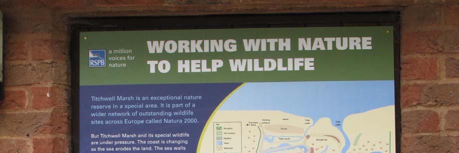
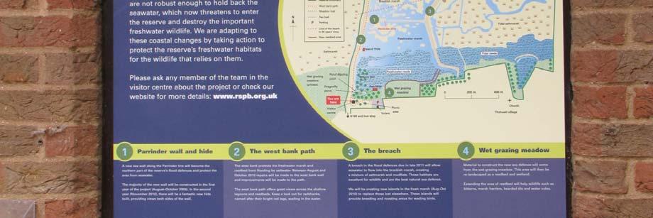

16 Interpretation boards installed to explain TacTICs
17 Communication was an important component of the project in order to build and retain support for the work at Titchwell. The 2009 edition of the Titchwell Coastal Bulletin was produced and distributed to local communities in the spring. A total of 900 copies were distributed of the bulletin were delivered to all households in Titchwell, Brancaster and Thornham parishes. The newsletter informed local residents of the work programme for the year and how to contact us if they had any queries or concerns. Seven thousand copies of a leaflet about the project were produced and made available to all visitors to the reserve, either for them to pick up themselves or via members of staff. A total of 196 guided walks, all of which were used to explain the project, were undertaken between 01/01/2009 and 31/12/2009, exceeding our target for the year of 160. Two press releases were issued during 2009 year, highlighting the work undertaken on the project and the funding received from LIFE+. Resulting articles in the local papers are included in Annex 5, together with additional articles generated by means other than press releases. Year Year 2 was the most disruptive year of the project as the main access path on the reserve along the West Bank had to be closed for the West Bank strengthening works. A formal application was made to the Norfolk County Council Highways Department for the temporary closure of the public footpath. The majority of the work to strengthen the West Bank was undertaken in 2010 and the height of the bank was raised to 5.8m AOD. Work on the Parrinder Wall between the location of the new hide and the West bank was also completed. The footpaths were re instated and re opened to the public as soon as was possible. New islands were created in the freshwater marsh as part of the programme to mitigate against the loss of the brackish marsh for breeding avocets and roosting waders. Because of old saltmarsh creeks crossing the freshwater marsh, it was not possible to use standard excavators to carry out this piece of work. A specialist contractor, Alaska Environmental Contracting, who own and operate a floating excavator that allows the operators to work on very soft ground or on water were used to do this work. Due to Titchwell s past use as a military training area, areas of the freshmarsh site also had to be surveyed and cleared of any unexploded ordnance before work could begin. Expert contractors were used for this element of the work.

18 Unexploded ordnance found in freshwater marsh Around 4,700ha of new islands were created and existing islands re profiled to make them more suitable for breeding avocets and roosting waders. We also excavated new channels in the freshwater marsh to improve water flow and create wet areas closer to the new hide. Using a special macerating head, we also used the floating excavator to remove areas of reed that over the years had been encroaching onto the freshwater marsh. The macerating head broke the reed rhizomes into tiny segments that would not re grow. This increased the area of mud available for feeding birds and also improved viewing conditions for visitors to the reserve.


19 Alaska floating excavator macerating reed rhizomes in freshwater marsh Although not part of the LIFE funded project, the replacement Parrinder Hide was constructed. The 2010 edition of the Titchwell Coastal Bulletin was produced and distributed to local communities in the spring.


20 Year During the second year of work, it was realised that an error had been made on the planning permission boundary was incorrect and that the topographical survey of a section of west bank was incorrect and additional work was required to bring it up to the required flood defence standard. Due to the timescales involved, this work was carried out in year 2 and retrospective planning consent was secured through an additional planning application submitted in early In 2011 the final section from the new hide to the East Bank was completed. Following winter 2010 when minor erosion of topsoil was noted on the base of the completed bank the design was modified slightly to provide a sacrificial clay toe to the base. This erosion mentioned above had no impact on the structure of the bank and was primarily an aesthetic issue. This slight modification to design did not have an impact on the budget for this piece of work. The low lying stretch of the south east corner of the east bank was also completed and tied in with the 5m contour. The East Bank was breached on the 7th September 2011, a momentous day for the project. The breach day had been carefully planned to minimise health and safety risks to Lancaster s operatives who were working on soft ground and at height at different points during the day. It was important to get all the levels exactly correct as once the breach had occurred retrospective work would have been very difficult. The realignment area has been operating as expected and even the highest tides have not caused any damage to the Parrinder Bank. Outside the realignment, minor levels of erosion occurred on saltmarsh immediately adjacent to the breach but this was less significant than originally expected. Constructing the breach in the East Bank saltmarsh to the left, brackish marsh to the right.

21 The new sluice in the freshmarsh was installed. This has double the capacity of the old sluice and also enables a finer level of control of water levels. To celebrate the completion of the project, we held a thank you event for our funders and contactors on 16 October 2011, hosted by RSPB Vice President and TV naturalist Chris Packham. What used to be the brackish marsh has been re named Volunteer Marsh in recognition of the support the RSPB receives from its vast volunteer work force. The new reedbed area has been called Patsy s Reedbed in memory of one our valued volunteers who sadly died during the planning of the project. Celebration event held at end of project (left to right: Dr Mike Clarke RSPB Chief Executive; Chris Packham RSPB Vice President & Naturalist; Paul Forecast RSPB Regional Director Eastern England; Helen Deavin TacTICS Project Manager) The 2011 edition of the Titchwell Coastal Bulletin was produced and distributed to local communities in the spring.
22 Results & Conclusions Implementation of Managed Realignment Scheme The work on the sea walls was completed to time and budget. The sea defences protecting the internationally freshwater habitats are now protected by 5.8m AOD sea defences with a flood defence standard of 1 in 30 years. This should be sufficient to protect the site until a less erosive marine environment exists at Titchwell, as is predicted. The area from which the material for the sea defences was won was land formed and used to create an additional 2.4ha of reedbed habitat. By the end of the project, reed had started to naturally colonise the area and we anticipate that within ten years the area will be a fully functioning reedbed. In the freshmarsh, the success of the new islands has exceeded expectation as detailed in the next section. The maceration of encroaching reed using a previously untested technique was also extremely successful. The area previously covered by reed has been colonised by curled dock which has provided additional sources of seed food for wintering waterfowl. It is anticipated that repeated treatment will be required every five to ten years, depending on the rate of reed regrowth. The installation of the new freshmarsh sluice with twice the capacity of the old one has enabled water levels to be managed more dynamically than was possible before. The move from a dropboard to a tilting weir sluice also allows us to manage water levels more precisely so that we achieve the ideal water levels for passage wading birds. The eastern sea defence was breached in September 2011 allowing what was the brackish marsh to become intertidal. The realignment area has been operating as expected. Minor levels of erosion occurred on saltmarsh immediately adjacent to the breach but this was less significant than originally expected. No erosion of the new Parrinder Bank has been recorded and the highest tides have passed without incident. A monitoring programme to measure rates of sediment deposition and the development of saltmarsh vegetation has been implemented. Although it is too early to draw any conclusions, sediment is being deposited on the realignment area with every tide and natural creek systems are being formed as water drains out during the tidal cycle.
23 Monitoring of Mitigation & Compensation We were required to mitigate/compensate against the loss of nesting habitat for 52 pairs of avocet and did so through a combination of creating new nesting islands on the freshwater marsh at Titchwell (mitigation) and creating new nesting habitat at our reserves at Frampton Marsh and Freiston Shore (compensation). Allowing for the 31 pairs of avocet that nested at Freiston Shore prior to the start of the Titchwell MarshCoastal Change Project, across the three sites we would have to support a minimum of 83 pairs of avocet for the mitigation/compensation to be deemed successful. The new avocet nesting islands on the Titchwell fresh marsh have been successful with over 80 pairs of avocet using the islands to breed during This was the largest number of avocets ever to have nested at Titchwell and far exceeded the original target of pairs. At Frampton Marsh and Freiston Shore, following the work carried out, nesting avocet numbers have increased significantly from the baseline figure of 31 pairs. Year Freiston Shore Frampton Marsh Titchwell Total pairs 18 pairs 51 pairs pairs 39 pairs 84 pairs pairs 9 pairs* 80 pairs 134 pairs pairs 61 pairs 18 pairs 101 pairs *fewer than 2010 due to low water levels and fox disturbance Although the numbers of nesting avocet have fluctuated by site due to external factors beyond our control such as adverse weather or predation, overall we have maintained numbers and mitigated/compensated adequately for the loss of nesting habitat on the Titchwell brackish marsh. The new islands in the freshwater marsh were also created to mitigate against the loss of the brackish marsh as a high tide wader roost.
24 The table below shows the peak numbers of roosting waders on the new islands recorded during WeBS Counts in the years before, during and after the Titchwell Marsh Coastal Change Project. Although there is considerable variation between the counts, it is encouraging to see that all the key species are roosting in comparable numbers after the project compared to before. Before TaCTICS During and post TaCTICS Oystercatcher Golden plover Lapwing Knot Dunlin Bar tailed godwit Additional benefits An additional benefit of the works is that we have been able to extend the visitor trails around the new area of reedbed. Two raised viewing mounds with viewing screen have been created to allow visitors to look over the developing reedbed and native scrub has been planted between them to screen the reedbed. A narrow length of the haul road onto the eastern sea defence was also retained to aid access for management but also to create a new seasonal trail for visitors. The trail is only open during August, September and October to avoid disturbance to breeding and wintering birds but allows visitors a different view over the freshwater marsh during the autumn migration period. Demonstration days In July 2009, Titchwell hosted a visit from around 30 policy makers, government officials and scientists from Germany (the University of Oldenburg,) Sweden (the City of Arvika, the Swedish Geotechnical Institute and the Swedish Meterological and Hydrological Institute) and the Netherlands (Rykswaterstaat Zeeland, Provincie Zeeland and the University of Ghent). The visitors were interested in actions being taken in the UK to adapt to the impacts of climate change. In November 2009 the project hosted a visit from the Institute of Ecology and Environmental Management (IEEM) who held their autumn conference in Thetford on the subject of Protected Areas Past, Present and Prospects. The Titchwell Marsh Coastal Change Project was used as an example of how a major engineering project could be delivered to protect internationally important habitats within a highly designated landscape.

25 The Project Manager made a reciprocal visit to Germany in November 2009 to share information about the Titchwell project and learn from other experiences. Again, the focus of this visit was to discuss ways of managing the natural environment in the light of climate change. We also hosted visits from the Chief Executive of Norfolk County Council, who wanted to understand the issues facing this part of the coast; RSPB colleagues working on a similar scheme in Essex; staff from the Norfolk Wildlife Trust (NWT); members of the Institute of Ecology and Environmental Management and staff members from the Environment Agency. British Wildlife, the leading journal in the UK for professional ecologists and conservationists, ran a 7 page article in its February 2010 issue entitled Sea level rise: implications for people and wildlife (see Annex 7). This article includes a description and photograph of Titchwell. In October 2012, the Project Manager gave a presentation on the project to the Defra Marine Climate Change Impacts Partnership, a partnership of scientists, government, its agencies and NGOs which provides co ordinated advice on climate change impact on the UK s coast and seas. Finally, the Titchwell project had a high profile throughout the RSPB, and is being widely cited by staff of the organisation in their dealings with external audiences as an excellent example of adaptive management in the face of climate change. Relevant staff include Conservation Officers and senior managers in the RSPB s East of England region, members of the national Water Policy and Climate Policy teams, and members of the national Reserves and Protected Areas team.
26
27
28
Humber Management Scheme. Fact sheet: Wintering and passage birds
 Humber Management Scheme Fact sheet: Wintering and passage birds Introduction The Humber Estuary plays an international role in bird migration and is one of the most important wetland sites in the UK.
Strete to Limpet Rocks 6b75 and 6b76 SUMMARY OF PREFERRED PLAN RECOMMENDATIONS AND JUSTIFICATION
 Location reference: Policy Unit reference: Plan: Strete to Limpet Rocks 6b75 and 6b76 SUMMARY OF PREFERRED PLAN RECOMMENDATIONS AND JUSTIFICATION The coastline is characterised by vegetated sea cliffs,
Wallasea Wetland Creation Project
 September 2007 Newsletter 3 Wallasea Wetland Creation Project Update In 2006 Defra completed the construction of the wetland creation project on the North shore of Wallasea Island on the Crouch Estuary
Soft Engineering Case Study: Wallasea Island
 Soft Engineering Case Study: Wallasea Island Situation By the British Geographer Wallasea Island is on the south side of the Crouch Estuary in Essex and also linked to the Roach Estuary. These estuaries
THE MERSEY GATEWAY PROJECT (MERSEY GATEWAY BRIDGE) AVIAN ECOLOGY SUMMARY PROOF OF EVIDENCE OF. Paul Oldfield
 AVIAN ECOLOGY SUMMARY PROOF OF EVIDENCE OF. Paul Oldfield") HBC/14/3S THE MERSEY GATEWAY PROJECT (MERSEY GATEWAY BRIDGE) AVIAN ECOLOGY SUMMARY PROOF OF EVIDENCE OF Paul Oldfield 1 1 DESCRIPTION OF THE BIRDLIFE IN THE UPPER MERSEY ESTUARY LOCAL WILDLIFE SITE 1.1
HBC/14/3S THE MERSEY GATEWAY PROJECT (MERSEY GATEWAY BRIDGE) AVIAN ECOLOGY SUMMARY PROOF OF EVIDENCE OF Paul Oldfield 1 1 DESCRIPTION OF THE BIRDLIFE IN THE UPPER MERSEY ESTUARY LOCAL WILDLIFE SITE 1.1
Bittern (Botaurus stellaris)
") Bittern (Botaurus stellaris) 1 Definition The Bittern is confined almost entirely to wetlands dominated by reeds, where it feeds on fish, amphibians and other small water animals. The bird re-colonised
Bittern (Botaurus stellaris) 1 Definition The Bittern is confined almost entirely to wetlands dominated by reeds, where it feeds on fish, amphibians and other small water animals. The bird re-colonised
FORTH CROSSING BILL OBJECTION 88 RSPB SCOTLAND FORTH REPLACEMENT CROSSING: ENVIRONMENTAL STATEMENT
 FORTH CROSSING BILL OBJECTION 88 RSPB SCOTLAND FORTH REPLACEMENT CROSSING: ENVIRONMENTAL STATEMENT We refer to the above document which has been produced by Jacobs Arup on behalf of Transport Scotland.
Piping Plovers - An Endangered Beach Nesting Bird, and The Threat of Habitat Loss With. Predicted Sea Level Rise in Cape May County.
 Piping Plovers - An Endangered Beach Nesting Bird, and The Threat of Habitat Loss With Thomas Thorsen May 5 th, 2009 Predicted Sea Level Rise in Cape May County. Introduction and Background Piping Plovers
saline lagoons - Conserving saline lagoons & their birds on ten Natura 2000 sites in England LIFE99 NAT/UK/006086
 saline lagoons - Conserving saline lagoons & their birds on ten Natura 2000 sites in England LIFE99 NAT/UK/006086 Project description Environmental issues Beneficiaries Administrative data Read more Contact
4.18 HAMFORD WATER. LTC site code:
 4.18 HAMFORD WATER LTC site code: BH Centre grid: TM2325 JNCC estuarine review site: 110 Habitat zonation: 367 ha intertidal, 106 ha subtidal, 58 ha nontidal Statutory status: Hamford Water SPA (UK9009131),
NORFOLK BIODIVERSITY ACTION PLAN
 NORFOLK BIODIVERSITY ACTION PLAN Ref 1/S18 Tranche 1 Species Action Plan 18 STARLET SEA AMO Plan Author: Norfolk Wildlife Trust (Nematostella vectensis) Plan Co-ordinator: Coastal BAP Topic Group A tiny
4.20 BLACKWATER ESTUARY
 4.20 BLACKWATER ESTUARY LTC site code: CB Centre grid: TL9507 JNCC estuarine review site: 112 Habitat zonation: 2368 ha intertidal, 1587 ha subtidal, 766 ha nontidal Statutory status: Blackwater Estuary
Project description Environmental issues Beneficiaries Administrative data Read more
 LIFE Little Terns - Improving the conservation status of the little tern in the UK through targeted action at the most important colonies LIFE12 NAT/UK/000869 Project description Environmental issues Beneficiaries
Site Improvement Plan. Upper Nene Valley Gravel Pits SPA. Improvement Programme for England's Natura 2000 Sites (IPENS) Planning for the Future
 Planning for the Future") Improvement Programme for England's Natura 2000 Sites (IPENS) Planning for the Future Site Improvement Plan Upper Nene Valley Gravel Pits Site Improvement Plans (SIPs) have been developed for each Natura
Improvement Programme for England's Natura 2000 Sites (IPENS) Planning for the Future Site Improvement Plan Upper Nene Valley Gravel Pits Site Improvement Plans (SIPs) have been developed for each Natura
How will Slapton Ley Evolve in the Next 100 Years?
 How will Slapton Ley Evolve in the Next 100 Years? Summary A concern for the communities around Start Bay is that, much further in the future, evolution of the Slapton Line shingle beach will lead to a
Northampton Washlands: Frequently Asked Questions
 Northampton Washlands: Frequently Asked Questions Site Significance 1 Why is the site important for wildlife? 2 Why are over wintering birds of such high conservation importance? 3 What are the issues
Environmental Designations in Dorset. Dr Annabel King, Senior Ecologist, DCC
 Environmental Designations in Dorset Dr Annabel King, Senior Ecologist, DCC Annabel.king@dorsetcc.gov.uk 07779 428 378 Underlying legislation Bern Convention (Convention on the Conservation of European
Management Unit 2: East Beach to West Beach, Selsey
 Management Unit 2: East Beach to West Beach, Selsey Unit limits 4400m from 487200E, 094300N to 484450E, 093100N This Unit also forms Unit 1 of the South Downs SMP. Coastal processes The Selsey peninsula,
Site Improvement Plan. Ouse Washes SPA. Improvement Programme for England's Natura 2000 Sites (IPENS) Planning for the Future
 Planning for the Future") Improvement Programme for England's Natura 2000 Sites (IPENS) Planning for the Future Site Improvement Plan Ouse Washes Site Improvement Plans (SIPs) have been developed for each Natura 2000 site in England
Improvement Programme for England's Natura 2000 Sites (IPENS) Planning for the Future Site Improvement Plan Ouse Washes Site Improvement Plans (SIPs) have been developed for each Natura 2000 site in England
Feldale Internal Drainage Board Biodiversity Action Plan Report Drainage Ditch Action Plan
 Feldale Internal Drainage Board Biodiversity Plan Report 04-5 Drainage Ditch Plan IDB s Partners Date Indicators Report 4 Manage ditches for biodiversity as well as for drainage Identify ditches of conservation
The Long Point Causeway: a history and future for reptiles. Scott Gillingwater
 The Long Point Causeway: a history and future for reptiles Scott Gillingwater Environmental Effects Long Point World Biosphere Reserve UNESCO designated the Long Point World Biosphere Reserve in April
Cat Island Chain Restoration Project Brown County Port & Resource Recovery Department
 Cat Island Chain Restoration Project Brown County Port & Resource Recovery Department February 2, 2015 Fox River and Lower Green Bay Cat Island Chain - 1938 Cat Island Brown County Aerial Photography,
Residential Volunteer Internship Placement Information
 Fence building Image by Julia Makin Residential Volunteer Internship Placement Information Practical Conservation Intern, East of England: Frampton Marsh, Old Hall Marshes, Titchwell Marsh. Overall purpose
BIRD READING ASSIGNMENT
 Ocean Connectors BIRD READING ASSIGNMENT To do before the field trip, in class or at home 1. Students will read Wetland Neighbors. The reading is available on the next page and online at http://oceanconnectors.org/resources.
Migratory Shorebird Conservation Action Plan
 Migratory Shorebird Conservation Action Plan The Migratory Shorebird Conservation Action Plan (MS CAP) has been developed by a broad range of stakeholders from all across the country and internationally
North Solent Shoreline Management Plan. Appendix J: Appropriate Assessment
 North Solent Shoreline Management Plan Appendix J: Appropriate Assessment Contents Page No J1 INTRODUCTION...1 J1.1 Background...1 J1.2 Role of Organisations in the Appropriate Assessment Process...8
FLOOD CELL 5 IKEN MARSHES BENEFIT COST RATIO (BCR) 1.7 Appendix 12
 1.7 Appendix 12") FLOOD CELL 5 IKEN MARSHES BENEFIT COST RATIO (BCR) 1.7 Appendix 12 FEATURES The area in the flood plain is defined as all land below 5m contour which conforms to the EA s definition of the floodplain.
FLOOD CELL 5 IKEN MARSHES BENEFIT COST RATIO (BCR) 1.7 Appendix 12 FEATURES The area in the flood plain is defined as all land below 5m contour which conforms to the EA s definition of the floodplain.
Jackson Bottom Wetlands Preserve BCS Number: 47-14
 Jackson Bottom Wetlands Preserve BCS Number: 47-14 Site description author(s) Greg Gillson, Jackson Bottom Wetlands Preserve Primary contact for this site Ed Becker, Natural Resources Manager, Jackson
Residential Volunteer internship placement information:
 Fence building at Bolton Ings by Julia Makin Residential Volunteer internship placement information: Residential volunteering Internship, Ynys-hir Overall purpose of the role. We want you to help us maintain
ENDANGERED PLOVERS SINGING PRAISE FOR NEW NATURE TRUST LANDS
 ENDANGERED PLOVERS SINGING PRAISE FOR NEW NATURE TRUST LANDS NEWS RELEASE Embargoed until August 6 th at 10:30 am. Baccaro, N.S. (August 6) The Nova Scotia Nature Trust made yet another exciting leap forward
Assessing ornithological impacts associated with wind farm developments: surveying recommendations
 Assessing ornithological impacts associated with wind farm developments: surveying recommendations This information note has been written to provide guidance to developers, Competent Authorities and others
TEES TIDAL FLOOD RISK MANAGEMENT STRATEGY COMMENTS BY THE TEESMOUTH BIRD CLUB ON THE ENVIRONMENT AGENCY S SCOPING REPORT
 Tees Tidal Flood Risk Management Strategy Scoping Report April 2004 TEES TIDAL FLOOD RISK MANAGEMENT STRATEGY COMMENTS BY THE TEESMOUTH BIRD CLUB ON THE ENVIRONMENT AGENCY S SCOPING REPORT TEES ESTUARY
BYRON BIRD BUDDIES. ANNUAL REPORT September 2015 September 2016
 BYRON BIRD BUDDIES ANNUAL REPORT September 2015 September 2016 Byron Bird Buddies (BBB) is a small, self funded community education and conservation group focusing on the preservation of habitat for resident
Aythya nyroca Eastern Europe/E Mediterranean & Sahelian Africa
 Period 2008-2012 European Environment Agency European Topic Centre on Biological Diversity Aythya nyroca Eastern Europe/E Mediterranean & Sahelian Africa Annex I International action plan Yes SAP Ferruginous
Stone Curlew (Burhinus oedicnemus)
") Stone Curlew (Burhinus oedicnemus) 1 Definition The Stone Curlew is a migratory bird of dry, stony, open ground such as heathland and acid grassland. It is now largely confined to East Anglia, in particular
Stone Curlew (Burhinus oedicnemus) 1 Definition The Stone Curlew is a migratory bird of dry, stony, open ground such as heathland and acid grassland. It is now largely confined to East Anglia, in particular
Roberts Bank Terminal 2 Project Field Studies Information Sheet
 January 2013 Port Metro Vancouver is continuing field studies in January as part of ongoing environmental and technical work for the proposed. The is a proposed new multi berth container terminal which
LIFE Nature project Improving the status of the coastal lagoon Tryggelev Nor, Denmark Layman s report
 LIFE Nature project Improving the status of the coastal lagoon Tryggelev Nor, Denmark Layman s report Fyn County, Nature Management & Water Environment Division, in cooperation with the Danish Bird Protection
Scale Limits for Layers in the MAGIC Application
 Scale Limits for Layers in the MAGIC Application Layer Name Minimum Scale Maximum Scale Agricultural Land Classification - Provisional (England) 1:250,000 1:2,000,000 Ancient Woodland (England) - 1:500,000
Possible new marine Special Areas of Conservation and Special Protection Areas in Wales
 Possible new marine Special Areas of Conservation and Special Protection Areas in Wales Photo credit - PGH Evans / Seawatch Foundation // February 2015 www.naturalresourceswales.gov.uk This leaflet provides
LOCH LEVEN NATIONAL NATURE RESERVE (NNR) Proposed Local Access Guidance
 Proposed Local Access Guidance") LOCH LEVEN NATIONAL NATURE RESERVE (NNR) Proposed Local Access Guidance Summary This paper briefly outlines the rationale behind the proposed local access guidance for Loch Leven NNR. Introduction SNH
LOCH LEVEN NATIONAL NATURE RESERVE (NNR) Proposed Local Access Guidance Summary This paper briefly outlines the rationale behind the proposed local access guidance for Loch Leven NNR. Introduction SNH
Coastal wetland at risk
 South West NRM Case Study: A Peel-Harvey Catchment Council Project Coastal wetland at risk Project Title A Component of the Peel-Harvey Catchment Council s Ramsar Initiative CC082614: Implementing the
Calidris alpina schinzii Britain & Ireland/SW Europe & NW Africa
 Period 2008-2012 European Environment Agency European Topic Centre on Biological Diversity Calidris alpina schinzii Britain & Ireland/SW Europe & NW Africa Annex I International action plan Yes No Dunlin,
Working with wildlife A DAY IN THE LIFE
 EPA ACTIVITY WORKSHEET STUDENT PAGE 1 7 Theme Student Sheet. This is the story of a scientist and their work on a day to day basis. Objectives To give students an insight into the work of scientists and
2008 San Francisco Bay Shorebird Census
 2008 San Francisco Bay Shorebird Census San Francisco Bay is a great place for shorebirds! The salt ponds, tidal flats, marshes and seasonal wetlands provide important habitat for over a million resident
A Rising Tide: Conserving Shorebirds and Shorebird Habitat within the Columbia River Estuary
 A Rising Tide: Conserving Shorebirds and Shorebird Habitat within the Columbia River Estuary By Vanessa Loverti USFWS Migratory Birds and Habitat Programs, Portland, Oregon May 28, 2014 Outline of Talk
SPECIES ACTION PLAN. Rhinolophus ferrumequinum 1 INTRODUCTION 2 CURRENT STATUS 3 CURRENT FACTORS AFFECTING 4 CURRENT ACTION
 GREATER HORSESHOE BAT Rhinolophus ferrumequinum Hampshire Biodiversity Partnership 1 INTRODUCTION The greater horseshoe bat has been identified by the UK Biodiversity steering group report as a species
Thank-you for of 13 October 2008 asking my opinion on these matters. My answers to your questions are as follows:
 Louise Barton Lydd Airport Action Group The Hook Madeira Road Littlestone Kent TN28 8QX Dear Louise, 14 Wilderness Gardens, Northiam East Sussex, TN31 6GB Tel/Fax: 01926 642543 Email: brian.banks@swiftecology.co.uk
National Grid s commitments when undertaking works in the UK. Our stakeholder, community and amenity policy
 National Grid s commitments when undertaking works in the UK Our stakeholder, community and amenity policy Introduction This document describes the ten commitments we have made to the way we carry out
OVERVIEW INTRODUCTION TO SHOREBIRDS MANAGEMENT FOR SHOREBIRDS TVA REGIONAL SHOREBIRD PROJECT ESTIMATING SHOREBIRD NUMBERS
 SHOREBIRD CONSERVATION AND MONITORING RESOURCES US SHOREBIRD CONSERVATOIN PLAN http://www.fws.gov/shorebirdplan WATERFOWL MANAGEMENT HANDBOOK - http://www.nwrc.usgs.gov/wdb/pub/wmh/contents.html MANOMET
Appendix 35: Biodiversity Action Plan Summary
 Appendix 35: Biodiversity Plan Summary Ramsey Internal Drainage Board Biodiversity Plan Summary for Ramsey Internal Drainage Board (35) The actions listed in this appendix summarise Ramsey Internal Drainage
Length: 2.5 miles / 4km for short walk or 6miles / 9.6km for longer walk. Good For: Theme: Nature
 Walk 10: steart marshes nature reserve Length: 2.5 miles / 4km for short walk or 6miles / 9.6km for longer walk Good For: Theme: Nature Duration: 1 hour for short walk or three hours for longer walk. Notes:
The importance of Port Stephens for shorebirds. Alan Stuart Hunter Bird Observers Club
 The importance of Port Stephens for shorebirds Alan Stuart Hunter Bird Observers Club What we will cover tonight Migratory shorebirds their amazing story What shorebirds occur around Port Stephens? Which
Coldra Woods Hotel by Celtic Manor and Starbucks Drive Thru Restaurant. Dormouse Method Statement
 Coldra Woods Hotel by Celtic Manor and Starbucks Drive Thru Restaurant Broadhall (Coldra Woods) Ltd; Coldra Manor Resort and Idris Davies Ltd. Tel: 01225 783674 Email: shughes@environgauge.com St. John
Charette Vision #1 for 2050
 Charette Vision #1 for 2050 Bird use? mercury? Charette Vision #2 for 2050 Important Uncertainties Mercury Sediment Dynamics/Mudflats Bird Use of Different Habitats, esp. tidal marsh ponds/pannes Non-avian
Humboldt Bay NWR BCS number: 86-4
 Humboldt Bay NWR BCS number: 86-4 ***NOTE: We were unable to determine all necessary information for this site description. If you would like to contribute the needed information to this description, please
Danube Delta SITE INFORMATION. IUCN Conservation Outlook Assessment 2014 (archived) Finalised on 17 November 2015
 Finalised on 17 November 2015") IUCN Conservation Outlook Assessment 2014 (archived) Finalised on 17 November 2015 Please note: this is an archived Conservation Outlook Assessment for Danube Delta. To access the most up-to-date Conservation
IUCN Conservation Outlook Assessment 2014 (archived) Finalised on 17 November 2015 Please note: this is an archived Conservation Outlook Assessment for Danube Delta. To access the most up-to-date Conservation
Conserving the mangrove forests.
 Conserving the mangrove forests. The mangrove forests of Pretty Pool Creek and Four Mile Creek not only lend a unique beauty to the area, they also serve an important role in the environment s ecosystem.
FRESHWATER WETLANDS. The need for more in Eastern England
 FRESHWATER WETLANDS The need for more in Eastern England This leaflet focuses on Eastern England s freshwater wetlands RSPB Berney Marshes, Norfolk and the benefits of creating more. We hope we can work
Geo Factsheet September 2000 Number 100
 September 000 Number 00 Coastal Management at Selsey in West Sussex With the exception of certain parts of the Norfolk Coast, it may probably be said without fear of contradiction, that at no point in
WEST HENDON ECOLOGICAL MANAGEMENT PLAN. (Framework Docoument) June Peter Brett Associates
 June Peter Brett Associates") WEST HENDON ECOLOGICAL MANAGEMENT PLAN (Framework Docoument) June 2013 Peter Brett Associates FRAMEWORK FOR ECOLOGICAL MANAGEMENT PLAN 1.1 The document sets out a Framework for an Ecological Management
WEST HENDON ECOLOGICAL MANAGEMENT PLAN (Framework Docoument) June 2013 Peter Brett Associates FRAMEWORK FOR ECOLOGICAL MANAGEMENT PLAN 1.1 The document sets out a Framework for an Ecological Management
A Guide To Birding Lytchett Bay
 A Guide To Birding Lytchett Bay Lytchett Bay is situated on the northern shores of Poole Harbour and is made up of several important wildlife rich habitats. The area is owned and managed by several different
Roberts Bank Terminal 2 Project Field Studies Information Sheet
 May 2013 Port Metro Vancouver is continuing field studies in May as part of ongoing environmental and technical work for the proposed Roberts Bank Terminal 2 Project. Roberts Bank Terminal 2 Project The
Acrocephalus melanopogon
 Period 2008-2012 European Environment Agency European Topic Centre on Biological Diversity Annex I International action plan Yes No Moustached Warbler,, is a species of passerine bird in the warbler family
Cabra, Dublin 7. Appropriate assessment (screening) Report prepared for Crekav Trading GP Limited. November 2017
 Report prepared for Crekav Trading GP Limited. November 2017") Proposed development at Former CIE Lands, Carnlough Road, Cabra, Dublin 7 Appropriate assessment (screening) Report prepared for Crekav Trading GP Limited November 2017 Roger Goodwillie & Associates, Lavistown
Proposed development at Former CIE Lands, Carnlough Road, Cabra, Dublin 7 Appropriate assessment (screening) Report prepared for Crekav Trading GP Limited November 2017 Roger Goodwillie & Associates, Lavistown
A Guide To Birding Lytchett Bay
 A Guide To Birding Lytchett Bay Lytchett Bay is situated on the northern shores of Poole Harbour and is made up of several important wildlife rich habitats. The area is owned and managed by several different
Ruddy Turnstone. Appendix A: Birds. Arenaria interpres [M,W] New Hampshire Wildlife Action Plan Appendix A Birds-50
![Ruddy Turnstone. Appendix A: Birds. Arenaria interpres [M,W] New Hampshire Wildlife Action Plan Appendix A Birds-50](/thumbs/89/101188544.jpg "Ruddy Turnstone. Appendix A: Birds. Arenaria interpres [M,W] New Hampshire Wildlife Action Plan Appendix A Birds-50") Ruddy Turnstone Arenaria interpres [M,W] Federal Listing State Listing Global Rank State Rank Regional Status N/A N/A G5 SNR Very High Photo by Pamela Hunt Justification (Reason for Concern in NH) Populations
Ruddy Turnstone Arenaria interpres [M,W] Federal Listing State Listing Global Rank State Rank Regional Status N/A N/A G5 SNR Very High Photo by Pamela Hunt Justification (Reason for Concern in NH) Populations
Calidris alpina schinzii Baltic/SW Europe & NW Africa
 Period 2008-2012 European Environment Agency European Topic Centre on Biological Diversity Calidris alpina schinzii Baltic/SW Europe & NW Africa Annex I International action plan Yes No Dunlin, Calidris
AGRAS WETLAND - Implementation of management measures at the Agras wetland LIFE03 NAT/GR/000092
 AGRAS WETLAND - Implementation of management measures at the Agras wetland LIFE03 NAT/GR/000092 Project description Environmental issues Beneficiaries Administrative data Read more Contact details: Project
Report to Species at Risk Conservation Fund. Nova Scotia Nature Trust project - Hemeons Head Conservation Lands
 Report to Species at Risk Conservation Fund Nova Scotia Nature Trust project - Hemeons Head Conservation Lands Photo credit: Alix d Entremont Final Report November 26, 2014 1 Project Goal and Objectives
Chesil and the Fleet: Case History. A. General description and features of conservation importance
 Chesil and the Fleet: Case History This case history has been prepared as a record of the work undertaken on Chesil and the Fleet in establishing a management scheme on the site as a means of sharing the
Birds of the Manukau Harbour. Tim Lovegrove Natural Heritage Section Auckland Regional Council
 Birds of the Manukau Harbour Tim Lovegrove Natural Heritage Section Auckland Regional Council Significance of the Manukau for shorebirds About 250,000 waders occur in NZ Up to 60,000 of these occur in
Bittern Botaurus stellaris monitoring and research in the UK: Summary of the 2005 season
 Bittern Botaurus stellaris monitoring and research in the UK: Summary of the 2005 season By David Fairhurst, John Mallord, Chris Lodge, Ross Frazer, Will Miles, Keith Kellet, Simon Wotton and Richard Gregory.
3 March 2015 The Director Sustainable Fisheries Section Department of the Environment GPO Box 787 CANBERRA ACT 2601
 3 March 2015 The Director Sustainable Fisheries Section Department of the Environment GPO Box 787 CANBERRA ACT 2601 SustainableFisheries@environment.gov.au Dear Director, Birdlife Australia welcomes the
THE CEMEX AND RSPB BIODIVERSITY PARTNERSHIP
 THE CEMEX AND RSPB BIODIVERSITY PARTNERSHIP Helping to Build A Greater Britain A FEW WORDS... Jesus Gonzalez, President of CEMEX UK says: We are delighted that we are continuing our partnership with the
Roberts Bank Terminal 2 Project Field Studies Information Sheet
 July 2012 Port Metro Vancouver is continuing field studies in July as part of ongoing environmental and technical work for the proposed Roberts Bank Terminal 2 Project. Roberts Bank Terminal 2 Project
Project Summary. Predicting waterbird nest distributions on the Yukon-Kuskokwim Delta of Alaska
 Project Summary 1. PROJECT INFORMATION Title Project ID Predicting waterbird nest distributions on the Yukon-Kuskokwim Delta of Alaska WA2012_22 Project Period July 1, 2012 to June 30, 2014 Report submission
The Biodiversity Impact of Waterside Campus
 The Biodiversity Impact of Waterside Campus An interim report on the bird surveys November 2016 Jeff Ollerton, Janet Jackson, Duncan McCollin, Charles Baker* & Joanne Underwood* Faculty of Arts, Science
NATIONAL POLICY ON OILED BIRDS AND OILED SPECIES AT RISK
 NATIONAL POLICY ON OILED BIRDS AND OILED SPECIES AT RISK January 2000 Environment Canada Canadian Wildlife Service Environnement Canada Service canadien de la faune Canada National Policy on Oiled Birds
A volunteer-based program for the study of international migrations of shorebirds in the Western Hemisphere
 Estuary and inlet sandbars: an important wildlife resource Exemplified with counts from the International Shorebird Surveys Brian Harrington Manomet Center for Conservation Sciences The International Shorebird
Site Improvement Plan. Bowland Fells SPA. Improvement Programme for England's Natura 2000 Sites (IPENS) Planning for the Future
 Planning for the Future") Improvement Programme for England's Natura 2000 Sites (IPENS) Planning for the Future Site Improvement Plan Bowland Fells Site Improvement Plans (SIPs) have been developed for each Natura 2000 site in
Improvement Programme for England's Natura 2000 Sites (IPENS) Planning for the Future Site Improvement Plan Bowland Fells Site Improvement Plans (SIPs) have been developed for each Natura 2000 site in
SPECIES ACTION PLAN. Barbastella barbastellus 1 INTRODUCTION 2 CURRENT STATUS 3 CURRENT FACTORS AFFECTING BARBASTELLE BATS 4 CURRENT ACTION
 BARBASTELLE BAT Barbastella barbastellus Hampshire Biodiversity Partnership 1 INTRODUCTION The barbastelle bat is considered to be rare both in the UK 1 and throughout its range. The barbastelle bat has
Shorebird Roost Rehabilitation at Stockton Sandspit. Project Report 2016
 Shorebird Roost Rehabilitation at Stockton Sandspit Introduction Project Report 2016 Stockton Sandspit is a small but vital component of the Hunter Wetlands National Park and is regarded as one of the
Great Created Newt Survey Letter Report Project Code A Barrowcroft Wood, Bradley Hall Date: July 2012
 Great Created Newt Survey Letter Report Project Code A071725-5 Site: Barrowcroft Wood, Bradley Hall Date: July 2012 Background WYG Environment was commissioned by HIMOR in April 2012 to undertake great
Ladd Marsh Wildlife Area BCS number: 49-3
 Oregon Coordinated Aquatic Bird Monitoring: Description of Important Aquatic Bird Site Ladd Marsh Wildlife Area BCS number: 49-3 Site description author M. Cathy Nowak, Ladd Marsh Wildlife Area Biologist
Site Improvement Plan Minsmere to Walberswick Heaths and Marshes
 Improvement Programme for England's Natura 2000 Sites (IPENS) Planning for the Future Site Improvement Plan Minsmere to Walberswick Heaths and Marshes Site Improvement Plans (SIPs) have been developed
Developing Sustainable Dolphin-watching in the Shannon Estuary, Ireland
 Developing Sustainable Dolphin-watching in the Shannon Estuary, Ireland A submission to the European Destinations of Excellence Competition: Tourism and Protected Areas Prepared by Dr Simon Berrow Project
McNabney Marsh Nesting Bird Surveys
 McNabney Marsh 2014 Nesting Bird Surveys Prepared for: Mt View Sanitary District PO Box 2757 Martinez, CA 94553 Contact: Kelly Davidson 925.228.5635 Prepared by: PO Box 188888 Sacramento, CA 95818 Contact:
HABITATS REGULATIONS ASSESSMENT St. Anne s on the Sea Neighbourhood Plan Addendum to Screening Opinion OCTOBER 2016
 HABITATS REGULATIONS ASSESSMENT St. Anne s on the Sea Neighbourhood Plan Addendum to Screening Opinion OCTOBER 2016 CONTACTS JO WEAVER Senior Ecologist dd +44 (0)1453 423124 m +44 (0)7809 549186 e jo.weaver@arcadis.com
The Stour and Orwell Estuary
 The Stour and Orwell Estuary The Stour and Orwell Estuary A report on the first six years of monitoring following the Channel Dredge contract 2000-2006 The Stour and Orwell Estuary Environmental Review
Securing the stone-curlew. Summary report Securing the stone-curlew 1
 Securing the stone-curlew Summary report 2012 2016 Securing the stone-curlew 1 Working together Working together Working together, farmers and conservationists have recovered the numbers of UK stone-curlews
Sauvie Island Wildlife Area BCS number: 47-28
 Sauvie Island Wildlife Area BCS number: 47-28 Site description author(s) Mark Nebeker, Oregon Department of Fish and Wildlife, Sauvie Island Wildlife Area Manager Primary contact for this site Mark Nebeker,
Whittlesey & Drysides IDB Biodiversity Action Plan Report Drainage Ditch Action Plan
 Whittlesey & Drysides IDB Biodiversity Plan Report 04-5 Drainage Ditch Plan Manage ditches for biodiversity as well as for drainage Identify ditches of conservation interest and manage appropriately Support
18 July Keith Greer SANDAG 401 B Street, Suite 800 San Diego, CA Subject: Mission Bay Park Project Quarterly Report
 18 July 2012 Keith Greer SANDAG 401 B Street, Suite 800 San Diego, CA 92101 Subject: Mission Bay Park Project Quarterly Report Dates Reporting: April 6 th -July 6 th, 2012 Project Summary: The project
GORDONBUSH WINDFARM ENVIRONMENTAL STATEMENT FURTHER INFORMATION (2) NON-TECHNICAL SUMMARY SEPTEMBER Page 0
 NON-TECHNICAL SUMMARY SEPTEMBER Page 0") GORDONBUSH WINDFARM ENVIRONMENTAL STATEMENT FURTHER INFORMATION (2) NON-TECHNICAL SUMMARY SEPTEMBER 2006 Page 0 A. INTRODUCTION B. BIRDS In June 2003, Scottish and Southern Energy applied for consent under
GORDONBUSH WINDFARM ENVIRONMENTAL STATEMENT FURTHER INFORMATION (2) NON-TECHNICAL SUMMARY SEPTEMBER 2006 Page 0 A. INTRODUCTION B. BIRDS In June 2003, Scottish and Southern Energy applied for consent under
Residential Volunteer Internship placement information
 Andy Hay (rspb-images.com) Residential Volunteer Internship placement information Warden, Northern England Overall purpose of the role To deliver nature conservation on the ground as part of the team carrying
Breeding Curlew in Ireland
 Breeding Curlew in Ireland Dr Anita Donaghy Senior Conservation Officer, BirdWatch Ireland Eurasian Curlew Numenius arquata EUROPE 75% OF GLOBAL POPN 68,000 22,000 82,000 100? Key: Resident, Breeding
Sanderling. Appendix A: Birds. Calidris alba. New Hampshire Wildlife Action Plan Appendix A Birds-67
 Sanderling Calidris alba Federal Listing State Listing Global Rank State Rank Regional Status N/A N/A G5 SNR High Photo by Pamela Hunt Justification (Reason for Concern in NH) Populations of several migratory
Little Ringed Plover 2007
 Little Ringed Plover 2007 Title Breeding Plover Survey 2007 (Little Ringed Plover) (Note: In the breeding season of 2007, the BTO ran a UK-wide survey covering both Little Ringed Charadrius dubius and
Oregon Dunes National Recreation Area BCS Number: 47-5
 Oregon Dunes National Recreation Area BCS Number: 47-5 ***NOTE: We were unable to determine all necessary information for this site description. If you would like to contribute the needed information to
Research Ecologist British Trust for Ornithology
 Research Ecologist British Trust for Ornithology ABOUT THE BRITISH TRUST FOR ORNITHOLOGY BRITISH TRUST FOR ORNITHOLOGY a world inspired by birds and informed by science BTO harnesses the skills and passion