CBD. Distr. GENERAL. UNEP/CBD/SBSTTA/20/INF/23* 17 March 2016 ENGLISH ONLY
|
|
|
- Francine Hutchinson
- 6 years ago
- Views:
Transcription


1 CBD Distr. GENERAL UNEP/CBD/SBSTTA/20/INF/23* 17 March 2016 SUBSIDIARY BODY ON SCIENTIFIC, TECHNICAL AND TECHNOLOGICAL ADVICE Twentieth meeting Montreal, Canada, April 2016 Item 4.4 of the provisional agenda** ENGLISH ONLY REPORT OF THE NORTH-WEST INDIAN OCEAN AND ADJACENT GULF AREAS REGIONAL WORKSHOP TO FACILITATE THE DESCRIPTION OF ECOLOGICALLY OR BIOLOGICALLY SIGNIFICANT MARINE AREAS 1 INTRODUCTION 1. At its tenth meeting, the Conference of the Parties to the Convention on Biological Diversity requested the Executive Secretary to work with Parties and other Governments as well as competent organizations and regional initiatives, such as the Food and Agriculture Organization of the United Nations (FAO), regional seas conventions and action plans, and, where appropriate, regional fisheries management organizations (RFMOs) to organize, including the setting of terms of reference, a series of regional workshops, with a primary objective to facilitate the description of ecologically or biologically significant marine areas through the application of scientific criteria in annex I of decision I/20 as well as other relevant compatible and complementary nationally and intergovernmentally agreed scientific criteria, as well as the scientific guidance on the identification of marine areas beyond national jurisdiction, which meet the scientific criteria in annex I to decision I/20 (paragraph 36 of decision /29). 2. In the same decision, the Conference of the Parties requested that the Executive Secretary make available the scientific and technical data, and information and results collated through the workshops referred to above to participating Parties, other Governments, intergovernmental agencies and the Subsidiary Body on Scientific, Technical and Technological Advice (SBSTTA) for their use according to their competencies. * Also issued as UNEP/CBD/EBSA/WS/2015/2/4. ** UNEP/CBD/SBSTTA/20/1/Rev.1. 1 The designations employed and the presentation of material in this note do not imply the expression of any opinion whatsoever on the part of the Secretariat concerning the legal status of any country, territory, city or area or of its authorities, or concerning the delimitation of its frontiers or boundaries.
2 Page 2 3. Subsequently, at its eleventh and twelfth meetings, the Conference of the Parties considered the outcomes, respectively, of the first and second set of regional workshops conducted, and requested the Executive Secretary to further collaborate with Parties, other Governments, competent organizations, and global and regional initiatives, such as the United Nations General Assembly Ad Hoc Working Group of the Whole on the Regular Process for Global Reporting and Assessment of the State of the Marine Environment, including Socio-economic Aspects, the International Maritime Organization, the Food and Agriculture Organization of the United Nations, regional seas conventions and action plans, and, where appropriate, regional fisheries management organizations, with regard to fisheries management, and also including the participation of indigenous and local communities, to facilitate the description of areas that meet the criteria for EBSAs through the organization of additional regional or subregional workshops for the remaining regions or subregions where Parties wish workshops to be held, and for the further description of the areas already described where new information becomes available (decisions I/17 and II/22). 4. Pursuant to the above requests and with financial support from the Government of Japan, through the Japan Biodiversity Fund, the Secretariat of the Convention on Biological Diversity convened, in collaboration with the United Nations Environment Programme Regional Office West Asia (UNEP- ROWA), Convention on Migratory Species Office Abu Dhabi, the Regional Organization for the Conservation of the Environment of the Red Sea and Gulf of Aden (PERSGA), the Regional Organization for the Protection of the Marine Environment (ROPME), and the Abu Dhabi Global Environmental Data Initiative (AGEDI), the North-West Indian Ocean and Adjacent Gulf Areas Regional Workshop to Facilitate the Description of Ecologically or Biologically Significant Marine Areas (EBSAs). This workshop was hosted by the Ministry of Environment and Water of the Government of the United Arab Emirates and was held in Dubai, United Arab Emirates, from 20 to 25 April Prior to this workshop, a training day on CBD's work on marine and coastal biodiversity as well as EBSAs, was convened by the Secretariat of the Convention on Biological Diversity, in collaboration with the Commonwealth Scientific and Industrial Research Organization (CSIRO) of Australia, at the same venue on 19 April in Dubai. 6. Scientific and technical support for this workshop was provided by the Commonwealth Scientific and Industrial Research Organisation (CSIRO). The results of technical preparation for the workshop were made available in the meeting document entitled Data to Inform the CBD North-West Indian Ocean and Adjacent Gulf Areas Regional Workshop to Facilitate the Description of Ecologically or Biologically Significant Marine Areas (UNEP/CBD/EBSA/WS/2015/2/3). 7. The meeting was attended by experts from Djibouti, Egypt, Eritrea, India, Iran, Iraq, Kuwait, Oman, Pakistan, Qatar, Saudi Arabia, Sudan, United Arab Emirates, and Yemen (remote participation) as well as the United Nations Environment Programme Regional Office West Asia (UNEP-ROWA), the Convention on the Conservation of Migratory Species Office-Abu Dhabi2, the Regional Organization for the Conservation of the Environment of the Red Sea and Gulf of Aden (PERSGA), the Regional Organization for the Protection of the Marine Environment (ROPME), Abu Dhabi Global Environmental Data Initiative (AGEDI), Commonwealth Scientific and Industrial Research Organization (CSIRO), the Food and Agriculture Organization of the United Nations (FAO), South Asia Cooperative Environment Programme, Global Ocean Biodiversity Initiative, BirdLife International, Centre for Sustainable Development and Environment (CENESTA), Cousteau Society, Emirates Wildlife Society in association with WWF (EWS-WWF), Environment Society of Oman, Regional Commission for Fisheries (RECOFI)/Iran Fisheries Research Organization, Save Our Seas Foundation, and WWF-Pakistan. Some participants from Parties in this region were unable to attend the workshop for logistical reasons, although they had been invited and their travel had been arranged by the Secretariat based on nominations by their respective national focal points. Some Parties did not nominate an expert, although invited to do so by the Secretariat. The full list of participants is attached as annex I. 2 The expert from the Convention on the Conservation of Migratory Species Office-Abu Dhabi assisted the national focal point of Somalia to provide scientific inputs to the workshop discussion.
3 ITEM 1. OPENING OF THE MEETING UNEP/CBD/SBSTTA/20/INF/23 Page 3 7. On behalf of H.E. Rashid Ahmed Bin Fahad, Minister of Environment and Water, Government of the United Arab Emirates, H.E. Eng. Mariam Mohammed Saeed Hareb, Assistant Undersecretary for Water Resources and Nature Conservation Affairs, welcomed the participants to the meeting. She referred to this workshop as an important opportunity to enhance regional cooperation and build a common regional vision for identifying important marine areas in the region. She described the UAE's work in establishing national strategies on biodiversity and coastal and marine sustainability. In particular, she highlighted their programmes to preserve marine species such as mammals, turtles and seabirds, and also stressed that, despite the clear environmental and economic benefits of a healthy marine environment, these factors are rarely considered in economic planning. She outlined specific programmes that the UAE is involved in to address this gap, such as the UAE Smart Map of Natural Capital project, focused on evaluating the country s natural resources from both environmental and economic standpoints in order to account for their aggregate economic value. She also highlighted the National Blue Carbon project, undertaken in collaboration the Abu Dhabi Global Environmental Data Initiative and Environment Agency Abu Dhabi, which aims to expand knowledge on, and awareness of, blue carbon and the ecosystem services associated with it, as well as the importance of assessing carbon storage in coastal environments. She welcomed this meeting as a critical step in developing a flexible framework for cooperation and exchange of information among the countries in the region and wished all the experts great success in their work for the coming week. 8. On behalf of the Executive Secretary of the Convention on Biological Diversity, Ms. Jihyun Lee (CBD Secretariat) welcomed participants and thanked them for taking part in this workshop, the eleventh regional EBSA workshop convened by the Secretariat. She thanked the Government of the United Arab Emirates for hosting this important workshop and the Government of Japan, through the Japan Biodiversity Fund, for its financial support for the workshop. She also expressed her appreciation to UNEP-ROWA, the Convention on Migratory Species Office Abu Dhabi, PERSGA, ROPME, and AGEDI for their collaboration and support in the convening of this workshop. She also thanked CSIRO of Australia for their valuable contribution to the scientific preparation for the workshop. She highlighted the unique nature of marine and coastal biodiversity in the region, and its interconnections with social and cultural well-being. She also emphasized that this connection is at the heart of the proposed Sustainable Development Goal 14, focused on conserving and sustainably using the oceans, seas and marine resources for sustainable development. She stressed that a robust understanding of important marine areas is a key prerequisite to inform action to protect the ocean s role in sustainable development, and that, through an inclusive and science-driven process, the regional EBSA workshops have endeavoured to describe the areas of the oceans that are crucial to the healthy functioning of the global ecosystem. She encouraged the workshop participants to share information and work together in a collaborative manner to enhance and add value to what has been done in the region, and to provide a foundation for future action to conserve and sustainably use marine and coastal biodiversity. 9. On behalf of the Director of UNEP-ROWA, Mr. Iyad Abumoghli, Ms. Diane Klaimi, Regional Coordinator Ecosystems and Biodiversity, provided an opening statement. She thanked the host country, United Arab Emirates, and the CBD Secretariat for their continuous support to the biodiversity agenda in the region, as well as the Government of Japan. Ms. Klaimi explained how marine resources are crucial in the region, to sustain its communities and for human health. She noted that the region is witnessing overexploitation of its fisheries and unsustainable fishing practices in addition to pollution from land-based activities and marine debris as well as impacts from invasive alien species. However, only 0.8% oceans and 6% of regional seas are protected. Over 80% of fisheries are exploited and require a coordinated action for their sustainable use. CBD Parties are faced with many challenges in conserving marine biodiversity and its sustainable use and are now emphasizing the application of integrated ecosystem-based management approaches to address the threats from various sectors and sources in a coherent manner. Although national biodiversity strategies and action plans (NBSAPs) in the region have applied the ecosystem approach, fisheries continue to be over-exploited in the region, depleting marine resources and forcing fishers to delve deeper and utilize unsustainable fishing tools. Certification, environmental impact assessments and ecosystem-based management (EBM) tools need to be integrated
4 Page 4 within national processes and sectors. At the global level, RIO+20 outcomes and the post-2015 development agenda highlight marine ecosystems for regional support and strengthening through targetsetting, actions and indicators under Sustainable Development Goal 14 on sustainable oceans. She noted that ROWA would hold an Arab forum on the SDGs in Bahrain on 5 May 2015 to mobilize regional support and coordinated action at the highest levels on the global SDG process. She concluded that the workshop outcomes support SDG 14 as well as other related goals and must be raised to the ministerial process and integrated into the SDG intergovernmental process to achieve goal 14 on ocean sustainability. 10. Mr. Lyle Glowka, Executive Coordinator, Convention on Migratory Species Office Abu Dhabi, delivered opening remarks on behalf of the Convention on Migratory Species and the CMS Office Abu Dhabi. He welcomed participants to the workshop and to the UAE. He noted that this workshop is an excellent example of the vision and leadership that exists in the UAE at national and emirate levels, with respect to both biodiversity and migratory species. He pointed out the uniqueness of the region s biodiversity, including its marine migratory species waterbirds and seabirds, sharks and rays, whales and dolphins, dugongs or marine turtles which represent the region s marine biodiversity. He noted that at least four of the seven EBSA criteria correlate strongly with marine migratory species and, as a study commissioned by CMS Office Abu Dhabi has demonstrated, migratory marine species have been either a principle or contributing factor in the description of at least 80% of the more than 200 EBSAs identified to date. Furthermore, he noted that the information used to describe EBSAs may be useful in developing ecological networks that can contribute to the needs of migratory marine species and promote connectivity. For these reasons the CMS Conference of the Parties, at its 11 th meeting, in Quito, in November 2014, recognized the importance of the CBD EBSA process in supporting the work of the Convention on Migratory Species. He thanked the Environment Agency Abu Dhabi for its vision and for the generous financial support provided to the CMS Office Abu Dhabi over the past six years on behalf of the Government of the UAE, emphasizing the Office s commitment to continue its close working relationship with the Ministry to ensure that it continues to bring value to the country and the region. In closing, he said that it has been a privilege for the CMS Office Abu Dhabi to have been working closely with the Ministry, CBD Secretariat, UNEP-ROWA and CSIRO, to make the workshop a reality. He emphasized that this workshop would be a watershed event that brings the region closer together in a common quest to promote international cooperation to conserve marine biodiversity, and wished everyone a successful week. ITEM 2. ELECTION OF THE CHAIR, ADOPTION OF THE AGENDA AND ORGANIZATION OF WORK 11. After a brief explanation by the CBD Secretariat on procedures for electing the workshop cochairs, Mr. Rashid AlShihi (UAE) and Mr. Moustafa Fouda (Egypt), as offered by the host Government and proposed by an expert from Sudan and seconded by experts from Saudi Arabia and Djibouti, respectively, were elected as the workshop co-chairs. 12. Participants were then invited to consider the provisional agenda (UNEP/CBD/EBSA/WS/2015/2/1) and the proposed organization of work, as contained in annex II to the annotations to the provisional agenda (UNEP/CBD/EBSA/WS/2015/2/1/Add.1), and they adopted them without any amendments. 13. The workshop was organized in plenary and break-out group sessions. The co-chairs nominated the following rapporteurs to assist the CBD Secretariat in preparing summaries of the discussions to be undertaken at the plenary sessions for the draft workshop report, taking into consideration the expertise and experience of the workshop participants and in consultation with the CBD Secretariat: Agenda item 3 (Workshop background, scope and output): Mr. Lyle Glowka (CMS Office-Abu Dhabi) Agenda item 4 (Review of relevant scientific information): Mr. Piers Dunstan (CSIRO) Agenda item 5 (Description of EBSAs): Coordinators of break-out sessions
5 Page 5 Agenda item 6 (Identification of gaps): Mr. Muthian Thangaraja (ROPME), Mr. Maher Adbelaziz Amer (PERSGA), and Mr. Pulakesh Mondal (SACEP) ITEM 3. WORKSHOP BACKGROUND, SCOPE AND OUTPUT 14. Ms. Jihyun Lee (CBD Secretariat) briefed the meeting on the workshop objectives and expected outputs, building on her presentation on the CBD's EBSA process, delivered on the training day. 15. The workshop participants noted the following points regarding the COP guidance on the regional workshop process as well as the potential contribution of the scientific information produced by the workshops: (a) The Conference of the Parties to the Convention, at its tenth meeting, noted that the application of the scientific criteria in annex I of decision I/20 for the identification of ecologically or biologically significant areas presents a tool which Parties and competent intergovernmental organizations may choose to use to progress towards the implementation of ecosystem approaches in relation to areas both within and beyond national jurisdiction, through the identification of areas and features of the marine environment that are important for conservation and sustainable use of marine and coastal biodiversity (paragraph 25, decision /29); (b) The application of the EBSA criteria is a scientific and technical exercise, and the identification of EBSAs and the selection of conservation and management measures is a matter for States and competent intergovernmental organizations, in accordance with international law, including the United Nations Convention on the Law of the Sea (paragraph 26, decision /29); (c) The EBSA description process is open-ended, and additional regional or subregional workshops may be organized when there is sufficient advancement in the availability of scientific information (paragraphs 9 and 12, decision I/17); (d) Each workshop is tasked to describe areas meeting the scientific criteria for EBSAs or other relevant criteria based on best available scientific information. As such, experts at the workshops are not expected to discuss any management issues, including threats to the areas; and (e) The EBSA description process facilitates scientific collaboration and information-sharing at national, subregional and regional levels. 16. The workshop also noted the following regarding the application of the criteria: (a) The EBSA criteria can be applied on all scales from global to local. Once a scale has been selected, however, the criteria are intended to be used to evaluate areas and ecosystem features in a context relative to other areas and features at the given scale; (b) There are no thresholds that must be met and judgements are comparative to adjacent areas; the current ranking system (e.g., high, medium, low, no information) for assessing the areas meeting each EBSA criteria is devised to facilitate better understanding of available scientific information in describing the areas with regard to the extent to which they meet different criteria. The current ranking system, however, does not intend to compare the importance of each criterion; (c) Relative assessments are necessarily scale dependent. Relative significance of areas has generally been viewed from regional or large sub-regional scales; (d) Areas may meet multiple criteria, and that is important, but meeting just one strongly is also important; (e) Areas described to meet the EBSA criteria have ranged from relatively small sites to very extensive oceanographic features; and (f) Areas described to meet the EBSA criteria can be overlapped or nested. 17. Ms. Diane Klaimi (UNEP-ROWA) delivered a presentation on UNEP-ROWA s regional scientific programmes and mechanisms supporting EBSAs.
6 Page Mr. Lyle Glowka (CMS office-abu Dhabi) gave a presentation on examples of global, regional and local initiatives to identify the distribution, abundance and routes of migratory marine species in the North-West Indian Ocean region. 19. Mr. Muthian Thangaraja (ROPME) delivered a presentation on marine protected areas in the ROPME sea area (RSA). 20. Ms. Jane Glavan (AGEDI) gave a presentation on the AGEDI s work relevant to the description of areas meeting the EBSA criteria. 21. Mr. Tooraj Valinasab (Iran Fisheries Research Organization) gave a presentation on changes in biological diversity and ecosystems in the Gulf and Oman Sea. 22. Mr. Giuseppe Notarbartolo di Sciara (IUCN and IWC) and Mr. Ben Lascelles (BirdLife International) gave a presentation on consideration of migratory bird and mammal species in describing areas meeting the EBSA criteria. 23. Mr. Piers Dunstan (CSIRO) provided a regional overview of biogeographic information on open-ocean water and deep-sea habitats and discussed potential options for the geographic scope of the workshop. 24. Summaries of the above presentations are provided in annex II. 25. The geographic scope of the workshop is illustrated in the map in annex III. 26. The workshop noted that additional scientific information is available on the waters of the north coast of Somalia that was not available for the Southern Indian Ocean regional workshop on EBSAs (31 July - 3 August 2012, Flic en Flac, Mauritius). The workshop therefore agreed to have some overlap in its geographic scope with the one held for Southern Indian Ocean region. ITEM 4. REVIEW OF RELEVANT SCIENTIFIC DATA/INFORMATION/MAPS COMPILED AND SUBMITTED FOR THE WORKSHOP 27. For the consideration of this item, the workshop had before it two information notes by the Executive Secretary: document UNEP/CBD/EBSA/WS/2015/2/2, containing a compilation of the submissions of scientific information to describe ecologically or biologically significant marine areas in the North-West Indian Ocean and Adjacent Gulf Areas, submitted by Parties, other Governments and relevant organizations in response to the Secretariat s notification ( , dated 11 November 2014), and document UNEP/CBD/EBSA/WS/2015/2/3, Data to Inform the CBD North-West Indian Ocean and Adjacent Gulf Areas Regional Workshop to Facilitate the Description of Ecologically or Biologically significant Marine Areas, which was prepared by CSIRO in support of the workshop deliberation. The documents/references submitted prior to the workshop were made available for the information of workshop participants on the meeting website ( 28. In preparation for this and the subsequent agenda item, participants were provided with a series of presentations during the training day, including presentations on the scientific aspects of the EBSA criteria, the description of areas meeting the EBSA criteria, and potential use of the EBSA information to support implementation of the ecosystem approach. Participants also took part in a group exercise focused on use of scientific information to describe areas meeting the EBSA criteria, with a focus on examples in the North-West Indian Ocean and Adjacent Gulf Areas region. 29. Mr. Piers Dunstan provided a presentation on Review of relevant scientific data/information/maps compiled to facilitate the description of EBSAs in the North-West Indian Ocean and Adjacent Gulf Areas, based on document UNEP/CBD/EBSA/WS/2015/2/3. A summary of his presentation is provided in annex II. 30. Presentations on areas meeting the EBSA criteria were delivered by experts from Djibouti, Egypt, Eritrea, India, Iran, Iraq, Kuwait, Oman, Pakistan, Qatar, Saudi Arabia, Sudan, United Arab Emirates, and PERSGA (on behalf of the expert from Yemen), as well as BirdLife International, CENESTA and the Cousteau Society. The information provided in these presentations was considered in
7 Page 7 the description of areas meeting the EBSA criteria by the break-out groups. Each presentation provided an overview of the area considered, an assessment of the area against the EBSA criteria, scientific data/information available as well as other relevant information. 31. GIS data compiled for this workshop was available to workshop participants in hard-copy maps as well as in GIS database with open-source GIS software, for their use and analysis. 32. The workshop noted with great appreciation that the host country, United Arab Emirates, had organized two national workshops, involving various experts from different sectors, on the description of areas meeting the EBSA criteria, to provide scientific inputs to this regional workshop. Such efforts were highly commended as the best practice to be followed by all the countries participating in future regional workshops. ITEM 5. DESCRIPTION OF AREAS MEETING EBSA CRITERIA THROUGH APPLICATION OF THE SCIENTIFIC CRITERIA AND OTHER RELEVANT COMPATIBLE AND COMPLEMENTARY NATIONALLY AND INTERGOVERNMENTALLY AGREED SCIENTIFIC CRITERIA 33. Building upon the theme presentations and site-based presentations provided in the previous agenda items, the workshop participants exchanged their views on possible ways of organizing their work on assessing the scientific information compiled and submitted for the consideration of the workshop. 34. For effective review of available scientific information and assessment of potential areas meeting the EBSA criteria, the workshop participants were then split into three break-out groups, in accordance with the proposals presented in the previous agenda item, including: (i) PERSGA sub-group, (ii) ROPME sub-group, and (iii) SACEP sub-group. 35. Participants were assisted by the technical support team from CSIRO, including GIS operators, who made hard/electronic copies of the maps available for the deliberation of the break-out group discussion, and provided data in GIS database, and supported data analysis and interpretation as well as mapping of potential areas meeting the EBSA criteria. The technical support team also provided scientific inputs in preparing the description of areas with regard to the EBSA criteria. 36. During the break-out group discussions, participants worked on the description of areas meeting the EBSA criteria and drew approximate polygons of areas meeting the EBSA criteria on a map provided by the technical support team as they were completed to keep track of opportunities to extend or merge areas for EBSA description and to identify areas that had yet to be considered. 37. The results of the break-out groups were reported at the plenary for consideration. At the plenary session, workshop participants reviewed the draft descriptions of areas meeting the EBSA criteria proposed by the break-out group members, using templates provided by the CBD Secretariat, and considered them for inclusion in the final list of areas meeting the EBSA criteria. 38. The workshop participants agreed on descriptions of 31 areas meeting the EBSA criteria. They are listed in annex IV and described in its appendix. The map of described areas is contained in annex III. ITEM 6. IDENTIFICATION OF GAPS AND NEEDS FOR FURTHER ELABORATION IN DESCRIBING AREAS MEETING THE EBSA CRITERIA, INCLUDING THE NEED FOR THE DEVELOPMENT OF SCIENTIFIC CAPACITY AND FUTURE SCIENTIFIC COLLABORATION 39. Building on the workshop deliberation, the workshop participants were invited to identify, through break-out group sessions and plenary discussion, gaps and needs for further elaboration in describing areas meeting the EBSA criteria, including the need to develop scientific capacity and future scientific collaboration. The results of the plenary and subgroup discussions are compiled in annex V.
8 Page The workshop participants also noted some areas that have potential to meet the EBSA criteria, but could not be described at this workshop due to data paucity and lack of analysis. These areas are presented in annex VI as potential areas for future consideration through either national or regional EBSA processes. ITEM 7. OTHER MATTERS 41. The CBD Secretariat informed the participants that the Secretariat is providing capacity-building opportunities through the framework of the Sustainable Ocean Initiative, to address priority issues identified for respective regions concerning the achievement of the Aichi Biodiversity Targets in marine and coastal areas, pursuant to decisions /29, I/17, I/18, II/22, and II/23. The workshop participants, in particular, noted decision II/23, paragraph 19: "Requests the Executive Secretary to facilitate, through technical training and the information-sharing mechanism on ecologically or biologically significant marine areas, the use of scientific information compiled for the description of areas meeting the scientific criteria for ecologically or biologically significant marine areas to support efforts, at the regional or national level, on the use of marine spatial planning by Parties and competent intergovernmental organizations." ITEM 8. ADOPTION OF THE REPORT 42. The participants considered and adopted the workshop report on the basis of a draft report prepared and presented by the co-chairs with some changes. 43. The participants agreed that any additional scientific information and scientific references would be provided to the CBD Secretariat by workshop participants within two weeks of the closing of the workshop in order to further refine the description of areas meeting EBSA criteria contained in annex IV and its appendix. ITEM 9. CLOSURE OF THE MEETING 44. In closing the workshop, the workshop co-chairs, Mr. Moustafa Mokhtar Ali Fouda and Mr. Rashid Alshihi congratulated the participants on their hard work and excellent collaboration throughout the week. They commended the excellent scientific and technical support by the technical support team, and the efficient and effective servicing of the workshop by the CBD Secretariat members as well as the contributions of all the rapporteurs to the report preparation. Along with a number of participants they expressed their sincere thanks to the Government of United Arab Emirates for its warm hospitality and excellent logistical support. 45. The workshop was closed at 5:30 pm. on Friday, 24 April 2015.
9 Djibouti 1. Mr. Houssein Rirache Robleh Directeur de l Amenagement du Territoire et de l'environnement Ministère de l Habitat, de l Urbanisme et de l Environnement Djibouti, Djibouti Tel.: Fax: housseinrirach@yahoo.fr Egypt 2. Mr. Moustafa Mokhtar Ali Fouda Minister Advisor for Biodiversity Matters Ministry of State for Environmental Affairs 30 Misr Helwan Road El Zyrae Rd, Maadi Cairo, Egypt Tel.: drfoudamos@gmail.com; foudamos@link.net; Eritrea 3. Mr. Yohannes Teclemariam Mebrahtu Ministry of Marine Resources P.O. Box 27 Massawa, Eritrea ejohnsh@gmail.com India 4. Mr. Ritesh Joshi Deputy Director Ministry of Environment, Forests and Climate Change Government of India Indira Paryavaran Bhavan, Jor Bagh Road New Delhi , India Tel.: ritesh.joshi@nic.in Iran (Islamic Republic of) 5. Mr. Mohammad Talebi Matin Aquatics Expert Marine Ecobiology Bureau Department of Environment Hakim Highway Tehran 15899, Iran (Islamic Republic of) hd_matin56@yahoo.com Iraq 6. Mr. Talib Abbas Khalaf Professor Marine Biology, Marine Science Centre University of Basrah Basrah, Iraq drtalibabbas@hotmail.com; talib_kh@yahoo.com Annex I LIST OF PARTICIPANTS CBD Parties UNEP/CBD/SBSTTA/20/INF/23 Page 9 Kuwait 7. Mr. Abdullah Salim Yassen Al-Zaidan Marine Biology Specialist Shuaiba Environmental Centre Kuwait alzaidan.abdullah@gmail.com Oman 8. Mr. Saleh Naghmush Al-Saadi Head Biodiversity Development Section Ministry of Environment and Climate Affairs Postal Code 100 Muscat, Oman Tel.: Fax: sntsaleh@hotmail.com Pakistan 9. Mr. Mohammed Moazzam Khan Technical Advisor (Marine Fisheries) World Wildlife Fund-Pakistan Karachi, Pakistan mmoazzamkhan@gmail.com Qatar 10. Mr. Ali Jassim Al-Kwari Environmental Researcher Ministry of Environment / Wildlife Department Doha, Qatar Tel.: ajkuwari@moe.gov.qa; alialkuwary@hotmail.com Saudi Arabia 11. Mr. Michael Berumen Associate Professor Red Sea Research Center King Abdullah University of Science and Technology Thuwal, Saudi Arabia michael.berumen@kaust.edu.sa Sudan 12. Mr. Dirar Hassan Nasr Lecturer Faculty of Marine Science and Fisheries Red Sea University Sudan d_nasr47@hotmail.com
10 Page 10 United Arab Emirates 13. Mr. Ahmed Esmaeil Al -Hashmi Director, Biodiversity Department Ministry of Environment and Water Dubai, United Arab Emirates Tel.: Fax: aealhashmi@moew.gov.ae 14. Mr. Rashid AlShihi Oceanographic Specialist Ministry of Environment and Water Dubai, United Arab Emirates Tel.: rmalshihi@moew.gov.ae Yemen (remote participation) 15. Mr. Abdul Karim A.M. Nasher Saeed Professor Faculty of Science Sana'a University Yemen karimnasher@yahoo.com 16. Mr. Mohammed Abdulrahman Hassan Principal Specialist Environmental Studies and Research Marine Environment and Wildlife Section Environment Department Dubai Municipality Government of Dubai Dubai, United Arab Emirates Tel.: marabdulla@dm.gov.ae 17. Ms. Hind Mohsen Al Ameri Specialist Marine Threatened Species and Habitats Terrestrial and Marine Biodiversity Environment Agency Abu Dhabi Abu Dhabi, United Arab Emirates Tel.: hind.alameri@ead.ae 18. Ms. Jumana Al-Ansari Biology Researcher Environment Public Authority - Kuwait Adailiya, Kuwait jalansari86@gmail.com Abu Dhabi Global Environmental Data Initiative (AGEDI) 22. Ms. Jane Glavan Partnerships Manager Abu Dhabi Global Environmental Data Initiative Abu Dhabi, United Arab Emirates jglavan@ead.ae Observers 19. Mr. Hamood Khamis Al-Neeri Nature Reserve Specialist Ministry of Environment and Climate Affairs Postal Code 100 Muscat, Oman adaymaniyat@hotmail.com 20. Mr. Mohammed Ahmad Al-Khunji Nature Reserve Specialist Ministry of Environment of Qatar Doha, Qatar makhenji@moe.gov.qa 21. Mr. Mohammed Ali B. Qurban Manager, Marine Studies Section Center for Environment and Water, Research Institute King Fahd University of Petroleum and Minerals Box 756 Dhahran, Saudi Arabia mqurban@kfupm.edu.sa, mqurban@gmail.com Organizations
11 Page 11 BirdLife International 23. Mr. Ben Lascelles Senior Marine Officer BirdLife International Wellbrook Court Girton Road Cambridge, United Kingdom of Great Britain and Northern Ireland Tel.: +44 (0) Fax: +44 (0) Centre for Sustainable Development and Environment (CENESTA) 24. Mr. Koosha Dab Senior Advisor on Marine Ecology Centre for Sustainable Development and Environment (CENESTA) 108 Azerbaijan Ave Tehran, Iran (Islamic Republic of) Convention on the Conservation of Migratory Species Office Abu Dhabi (UNEP/CMS) 25. Mr. Lyle Glowka Executive Coordinator Convention on Migratory Species Office Abu Dhabi, United Nations Environment Programme c/o Environment Agency Al Mamoura Building A, Al Muroor Road (Street No. 4) Abu Dhabi, United Arab Emirates Tel.: (mobile) Cousteau Society 26. Mr. Tarik Chekchack Director for Sciences and Environment Cousteau Society Paris, France Emirates Wildlife Society in association with World Wildlife Fund (EWS-WWF) 27. Ms. Marina Antonopoulou Marine Programme Manager Emirates Wildlife Society Dubai, United Arab Emirates Tel.: Environment Society of Oman (ESO) 28. Ms. Suaad Al Harthi Program Director Environment Society of Oman Muscat, Oman Tel.: ext Food and Agriculture Organization (FAO) 29. Ms. Paula Anton Junior Fisheries and Aquaculture Officer Regional Office for Near East and North Africa Food and Agriculture Organization of the United Nations (FAO) 11, Al Eslah El Zerai St., Dokki-Cairo, Egypt Tel.: (Ext. 2815) Mr. David Currie Officer-in-Charge and Fishery and Aquaculture Officer FAO Subregional Office for the Gulf Cooperation Council States & Yemen, SNG Ministry of Environment & Water Abu Dhabi, United Arab Emirates Global Ocean Biodiversity Initiative (GOBI) 31. Mr. Giuseppe Notarbartolo di Sciara GOBI and International Whaling Commission Via B. Marcello 43 Milano Italy Tel.: Fax: The Regional Organization for the Conservation of the Evironment of the Red Sea and Gulf of Aden (PERSGA) 32. Mr. Maher Adbelaziz Amer Coordinator Regional Biodiversity and MPAs Program PERSGA P.O. Box Jeddah 21583, Saudi Arabia Regional Commission for Fisheries (RECOFI) 33. Mr. Tooraj Valinasab Professor Head of Marine Stock Management Division Iran Fisheries Research Organization P.O. Box Tehran, Iran (Islamic Republic of) Regional Organization for the Protection of the Marine Environment (ROPME) 34. Mr. Muthian Thangaraja Marine Environment Expert Regional Organization for the Protection of the Marine Environment P.O. Box: Safat, Kuwait
12 Page 12 Save Our Seas Foundation 35. Ms. Rima W. Jabado Lead Scientist Gulf Elsasmo Project Save Our Seas Foundation Dubai, United Arab Emirates South Asia Co-operative Environment Programme 36. Mr. Pulakesh Mondal Senior Programme Officer (Regional) South Asia Seas Programme (SASP) South Asia Co-operative Environment Programme #10 Anderson Road Colombo 5, Sri Lanka Commonwealth Scientific and Industrial Research Organisation (CSIRO) 39. Mr. Piers Dunstan Research Scientist Marine and Atmospheric Research Commonwealth Scientific and Industrial Research Organisation Castray Esplanade Hobart, Australia Technical Support United Nations Environment Programme Regional Office for West Asia (UNEP-ROWA) 37. Ms. Diane Klaimi Regional Coordinator Ecosystems and Biodiversity United Nations Environment Programme UNEP-ROWA P.O. Box Manama, Bahrain Wildlife Institute of India 38. Mr. K. Sivakumar Scientist 'E' Wildlife Institute of India P.B. #18, Chandrabani Dehradun , India Mr. Mike Fuller Spatial Analyst Marine and Atmospheric Research Commonwealth Scientific and Industrial Research Organisation Castray Esplanade Hobart, Australia Ms. Donna Hayes Marine and Atmospheric Research Commonwealth Scientific and Industrial Research Organisation Castray Esplanade Hobart, Australia Secretariat of the Convention on Biological Diversity (SCBD) 42. Ms. Jihyun Lee Environmental Affairs Officer for marine and coastal biodiversity Science, Assessment and Monitoring Secretariat of the Convention on Biological Diversity 413, Saint-Jacques Street W. Suite 800 Montreal H2Y 1N9, Canada Mr. Joseph Appiott Associate Programme Officer for marine and coastal biodiversity Science, Assessment and Monitoring Secretariat of the Convention on Biological Diversity 413, Saint-Jacques Street W. Suite 800 Montreal H2Y 1N9, Canada Ms. Jacqueline Grekin Programme Assistant Science, Assessment and Monitoring Secretariat of the Convention on Biological Diversity 413, Saint-Jacques Street W. Suite 800 Montreal H2Y 1N9, Canada Tel.:
13 Page 13 Annex II Agenda Item 3. SUMMARY OF THEME PRESENTATIONS UNEP-ROWA's regional scientific programmes and mechanisms supporting EBSAs (by Diane Klaimi, United Nations Environment Programme Regional Office for West Asia (UNEP-ROWA) Ms. Klaimi provided an overview of UNEP s global and regional scientific programmes and mechanisms that can promote, support and contribute to the description of areas meeting the EBSA criteria in the North-West Indian Ocean region. The ROWA office in Bahrain offers programmes to strengthen the institutional capacity of its 12 member States to respond to the conservation and sustainable use of marine ecosystems and their biodiversity and ecosystem services, the management of regional emerging issues related to ecosystem degradation (terrestrial, aquatic and coastal), and strengthening the implementation of biodiversity and marine-related multilateral environmental agreements (MEAs) and their coherence. In doing so, ROWA aims to strengthen the application of the ecosystem approach and the use of ecosystembased management (EBM) tools in the region and integration into national development processes, especially within the process of revising national biodiversity strategies and action plans (NBSAPs) in line with the Strategic Plan for Biodiversity At the institutional level, UNEP collaborates with the League of Arab States and other regional mechanisms to strengthen the implementation of MEAs related to marine biodiversity. She then highlighted the UNEP s Regional Seas Programme (RSP), comprising 18 regional seas conventions and their member states. The Regional Organization for the Protection of the Marine Environment (ROPME) and the Regional Organization for the Conservation of the Environment of the Red Sea and Gulf of Aden (PERSGA) collaborate with UNEP-ROWA through partnerships that aim to promote cooperation on EBM, climate-change adaptation, marine ecosystem assessments, governance and awareness. The RSP aims to address coastal issues on: land-based sources of marine and coastal pollution; ship-generated marine pollution, such as oil, chemicals, litter, and invasive species; the destruction of ecosystems and habitat caused by increased urbanization and coastal development; the conservation and management of marine and coastal ecosystems; integrated coastal zone management, and integrated coastal area and river basin management; the over-exploitation and depletion of living marine resources, including fisheries; and monitoring, reporting and assessing the marine environment. In addition, ROWA has existing partnerships with other regional and global organizations such as the AGEDI, United Nations Environment Programme Mediterranean Action Plan (UNEP-MAP), Food and Agriculture Organization of the United Nations (FAO), Convention on International Trade in Endangered Species of Wild Fauna and Flora (CITES), Convention on Migratory Species (CMS), and the Ramsar Convention, which promote data-sharing and management through national reporting, capacity-building, addressing joint action plans aimed at managing marine biodiversity issues and harmonizing them into a regional strategy and action plan whilst strengthening intergovernmental processes and government/private sector partnerships to manage threats from land-based activities. Examples of Global, Regional and Local Initiatives to Identify the Distribution, Abundance and Routes of Migratory Marine Species in the North-west Indian Ocean Region (by Lyle Glowka, Convention on Migratory Species Office Abu Dhabi) Mr. Glowka introduced the Convention on Migratory Species (CMS) and the four CMS instruments most relevant to the region (African-Eurasian Migratory Waterbird Agreement AEWA, Sharks MoU, Dugongs MoU and Indian Ocean Southeast Asia Marine Turtles IOSEA MoU), which promote
14 Page 14 individual and cooperative State actions across the migratory range of a particular species or group of species by addressing threats, promoting the maintenance of networks of suitable habitats and promoting research as well as information exchange. He explained that traditional survey methods, such as aerial surveys, are resource intensive but provide information on abundance and distribution. Satellite and other tracking technologies are becoming more accessible and can be used to more precisely determine the location of migratory routes. A non-exhaustive web-based review of regional and local initiatives by major species group, drawing, for example, from wildtracking.org, seaturtle.org, seabirdtracking.org, and the CMS IOSEA satellite-tracking meta-database, identified a number of relevant local and regional projects and initiatives, including, inter alia: waterbirds and seabirds (BirdLife International Important Bird and Biodiversity Areas initiative, greater flamingo Abu Dhabi, and Socotra cormorant tracking in Umm Al Quwain; fish (whale shark in Southern Red Sea and Qatar, billfish tracking in Abu Dhabi, and shark market surveys in UAE and Saudi Arabia Red Sea); marine mammals (IUCN Important Marine Mammal Areas initiative, dugong aerial surveys and tracking in Abu Dhabi, and Arabian Sea humpback whale tracking in Oman); and marine turtles (hawksbill turtles in Iran, Oman, Qatar and United Arab Emirates, green turtles in Saudi Arabia and Yemen, loggerhead turtles in Oman and Yemen, and Olive Ridley turtles in Oman). He noted that the region s migratory marine species richness needs to be understood and promoted to ensure good policy and decision-making. Baselines, migratory routes and ecological requirements need to be established. Obstacles for research, data generation and sharing should be identified and overcome. This could be achieved by building capacity, promoting collaboration and awareness, uploading information on surveys and tracking to publicly accessible meta-databases, exploring the opportunities for promoting open science and open access, increased opportunities for the research and conservation community to meet regularly in workshops and conferences, exchange of information, as well as increasing the number of peer-reviewed publications and exploring opportunities for private sector engagement. Marine Protected Areas in the ROPME Sea Area (RSA) (by Mr. Muthian Thangaraja) Mr. Thangaraja explained that the Regional Organization for the Protection of the Marine Environment (ROPME) supports its Member States (Bahrain, Iran, Kuwait, Oman, Qatar, Saudi Arabia and United Arab Emirates) in establishing marine protected areas. Upon ratification and accession of the Convention on Biological Diversity, ROPME Member States designated marine protected areas (MPAs) in selected key ecosystems in the region, and plan for further designations in the future to attain Aichi Biodiversity Target 11. They are committed to the Strategic Plan for Biodiversity and its Aichi Biodiversity Targets and are working towards implementing Strategic Goal C to improve the status of biodiversity by safeguarding ecosystems, species and genetic diversity. ROPME Member States plan to allocate 10% of their coastal and marine areas, especially areas of particular importance for biodiversity and ecosystems, and integrate them into wider landscapes and seascapes by 2020 (Aichi Biodiversity Target 11). The total number of MPAs in the ROPME region is 177, comprising 67 designated MPAs, 109 proposed MPAs, eight Ramsar sites, two biosphere reserves under the UNESCO Man and the Biosphere Programme (UNESCO-MAB) and a few proposed World Heritage sites. Altogether, MPAs cover 7.8% (36 sites, km 2 ) of the ROPME Sea Area. Work of the Abu Dhabi Global Environmental Data Initiative (AGEDI) relevant to the description of EBSAs (by Jane Glavan, AGEDI) Ms. Glavan presented AGEDI projects related to the EBSA process. She explained that systematic Conservation Planning (SCP) seeks to assess biodiversity in a robust, repeatable and scientific manner
15 Page 15 and thereby to identify the best places in a landscape to undertake conservation activities such as expansion of protected areas. The outputs of the MARAN analyses were used to identify 22 Priority Focus Areas for the UAE, while 35 Priority Focus Areas were identified across the Arabian Peninsula. Coastal habitats provide a myriad of essential ecosystem services. They support fisheries, protect shorelines, provide opportunities for tourism, and are important for cultural heritage and identity. The UAE Blue Carbon Programme aims to improve our understanding of carbon sequestration and the other ecosystem services that coastal blue carbon ecosystems provide in Abu Dhabi. The Ecosystems Services Assessment project was designed to provide an analysis of water quality impacts on amenity values in Abu Dhabi and Western Region study areas. AGEDI has also embarked on the implementation of the Local, National, Regional Climate Change Assessment Programme, encompassing 12 highly integrated sub-projects. These sub-projects are organized around five thematic areas: regional climate change, environment, water resources, coastal zones and socio-economic systems. Ultimately, the project aims to develop and provide access to usable, high-quality environmental data within the context of effective stakeholder engagement and enhanced decision-making within the region. She concluded by noting that data are freely available upon request and invited participants to seek further information on AGEDI at: Changes in Biological diversity and Ecosystems in the Gulf and Oman Sea (by Tooraj Valinassab,Iranian Fisheries Research Organization IFRO) Mr. Valinasab explained that the Gulf is a semi-closed water body connected to the Oman Sea through the Strait of Hormuz. Its maximum width is 640 km, and its average depth is 35m.The Oman Sea, with an area of 94,000 km 2 and a depth reaching 3400 m, connects the Gulf to the Indian Ocean through the Arabian Sea, with oceanic characteristics. The Gulf and the Oman Sea are in the subtropical zone, lying almost entirely between the latitudes of 24 and 30 N and longitudes of 49 to E. Average annual rainfall is 3 to 8 cm per year. The dominant large-scale current is counter-clockwise, with less saline (and less dense) water entering the Strait of Hormuz at the surface and more saline (and denser) water leaving the area at the bottom. However, primary productivity for the Gulf and the Oman Sea is observed only at average level, being higher than most of the Red Sea but lower than the Arabian Sea. The bottom topography is mostly flat, dominated by soft sediments and a few rocky substrates in the Oman Sea. Various aquatic species are found in the area, with about 900 fish species, more than 200 species of crabs, about 25 species of shrimps and also a high biodiversity of deep-sea species, few of which have been identified. According to different research studies carried out in this region, the density of some species is declining (e.g., silver pomfret, sharks), while the density of others is increasing. Some dominant species are emerging, including threadfin bream and lizardfish, while some species are endangered (e.g., horsefish, pristis). Environmental changes have been significant, especially in the north-western Gulf, and unsustainability is observed due to human factors and climate change. Oil and gas pollution, urban and industrial discharge, and pollution associated with commercial transport and fishing vessels are high in the region, and in recent years the phenomenon of red tides and blooms has been recorded more frequently. Consideration of Migratory Bird and Mammal Species in Describing EBSAs (by Giuseppe Noarbartolo di Sciara, GOBI, and Ben Lascelles, BirdLife International) In this joint presentation, Mr. Lascelles began by explaining that BirdLife s Important Bird and Biodiversity Areas (IBA) programme has been used to set conservation priorities for more than 30 years. IBA sites can act as a shadow list for protected areas (e.g., EU Birds Directive, RAMSAR) and have been used to inform the description of areas meeting the EBSA criteria. To date over 13,000 IBAs have been identified globally, including over 3000 marine sites ( Sites qualify
16 Page 16 when IBA criteria and thresholds are met. For seabirds, IBAs are identified for congregations (areas holding >1% global population), threatened species (IUCN Red Listed), and biome- and range-restricted species. IBA criteria therefore show significant overlap and congruence with EBSA criteria, particularly in relation to sites of importance for life history stages and threatened species. A range of seabird data has been compiled through generous contributions from seabird scientists and submitted for consideration at this EBSA workshop (e.g This data has been analysed to show locations of breeding colonies and at-sea areas where one or more EBSA criteria can be shown to have been met. Mr. Lascelles noted that further information can be found in the background documents submitted to this workshop. Mr. Noarbartolo di Sciara then went on to describe Important Marine Mammal Areas (IMMAs), discrete portions of habitat that are important to marine mammal species and that could be delineated and managed for area-based conservation. They can be seen as a potential marine mammal layer for consideration by governments, intergovernmental organizations, conservation groups and the general public. IMMAs are being developed by the IUCN Species Survival Commission World Commission on Protected Areas (SSC-WCPA) Marine Mammal Protected Areas Task Force (MMPATF) through a standardized process to prepare data for the CBD EBSA process, and as a tool for marine spatial planning (MSP) and the selection of marine protected areas (MPAs) and MPA networks, particularly sensitive sea areas under the International Maritime Organization, as well as IUCN marine key biodiversity areas, as part of ecosystem conservation in national waters and in areas beyond national jurisdiction. Besides the ongoing EBSA process, the context of their work is provided by marine spatial planning (MSP), a process for analysing and allocating the spatial and temporal distribution of human activities in marine areas to achieve ecological and economic objectives. MSP is a practical way to create and establish a more rational use of marine space and the interactions between its uses and users, to balance demands for development with the need to protect the environment, and to achieve social and economic objectives in an open and planned way. Many marine mammal species are flagship or umbrella species and act as indicators for ecosystem health. Consequently, knowledge of areas that are important for these species will facilitate the balancing of human uses of the seas with the imperative of conserving marine biodiversity. The networking of IMMAs will thus represent a cost-effective approach to conservation, by helping to supply the basis for MSP and supporting marine biodiversity conservation efforts in general. Regional Overview of Biogeographic Information on Open-ocean Water and Deep-sea Habitats and Geographic Scope of the Workshop (by Piers Dunstan, Commonwealth Scientific, Industrial and Research Organization CSIRO). Mr. Dunstan presented a summary of the broad bioregions of the North-West Indian Ocean. He showed how the broader oceanic circulation created a region separate from the broader Indian Ocean. He then showed the bioregions identified by the marine ecosystems of the world and showed how the coral reefs of this region were significantly different from the reefs of the broader Indian Ocean. He suggested this provided the rationale for using the ecosystem characterization to define the geographic scope of the workshop. He further suggested that the workshop could attempt to describe an area meeting the EBSA criteria within each of the marine provinces identified. Agenda Item 4. Review of Scientific Information Compiled (by Piers Dunstan, Commonwealth Scientific, Industrial and Research Organization CSIRO)
17 Page 17 Mr. Dunstan presented the data collated for the workshop and described the application of information to the EBSA criteria. He emphasized that the description of an area meeting the EBSA criteria were undertaken at a regional scale. Mr. Dunstan then presented a brief summary of the data collated, as contained in document UNEP/CBD/EBSA/WS/2015/1/3, /official/ebsaws en.pdf, which describes a subset of the important data sets that could be used, for consideration by the workshop participants. The data sets showed biological and ecological data that could be used to describe areas meeting the EBSA criteria, including habitat maps, turtle tracking, coral reefs and important bird areas. He also showed physical data sets that could be used, including maps of benthic geomorphology, oceanic climatologies and derived data sets like SST frontal zones. Regarding the issue of whether multiple nearby areas should be aggregated to form a single, larger area meeting the EBSA criteria, He suggested that this would be appropriate if the ecological system were shared and if there were clear links between the areas.

18 Page 18 Annex III MAP OF THE WORKSHOP'S GEOGRAPHIC SCOPE AND AREAS MEETING EBSA CRITERIA IN THE NORTH-WEST INDIAN OCEAN AND ADJACENT GULF AREAS AS AGREED BY THE WORKSHOP PLENARY Note: Polygon in pale blue indicates the geographic scope of the area considered by the workshop Polygons in red indicate areas described as meeting the EBSA criteria by the workshop
19 Page 19 Annex IV DESCRIPTION OF AREAS MEETING THE EBSA CRITERIA IN THE NORTH-WEST INDIAN OCEAN AND ADJACENT GULF AREAS AS AGREED BY THE WORKSHOP PLENARY Area Number Areas meeting the EBSA criteria (See the detailed description of compiled areas in appendix to annex IV) 4 1 Southwest Waters of Abu Dhabi 2 Marawah 3 Jabal Ali 4 Khor Kahlba 5 Sir Bu Na air Island 6 Sulaibikhat Bay 7 Qaro and Umm Al-Maradem 8 Nayband Bay 9 Qeshm Island and Adjacent Marine and Coastal Areas 10 Churna-Kaio Island Complex 11 Khori Great Bank 12 Malan-Gwader Complex 13 Miani Hor 14 Arabian Sea Oxygen Minimum Zone 15 Indus Estuarine Area and Associated Creeks 16 Sandspit/Hawks Bay and Adjacent Backwaters 17 Angria Bank 18 Socotra Archipelago 19 The Great Whirl and Gulf of Aden Upwelling Ecosystem 20 Îles des Sept Frères et Godorya (Seven Brothers Islands and Godorya 21 Southern Red Sea Islands 22 Southern Red Sea Pelagic Ecosystems 23 Sanganeb Atoll/Sha ab Rumi 24 Dungonab Bay/Mukawar Island Area 25 Suakin Achipelago and Sudanese Southern Red Sea 26 Wadi El-Gemal Elba 27 Arabian Basin 28 Daymaniyat Islands 29 Oman Arabian Sea 30 Shatt Al-Arab Delta 31 Makran/Daran-Jiwani Area
20 Page 20 Appendix to annex IV DESCRIPTION OF AREAS MEETING THE EBSA CRITERIA IN THE NORTH-WEST INDIAN OCEAN AND ADJACENT GULF AREAS REGION AS AGREED BY THE WORKSHOP PLENARY Area no. 1: South-west Waters of Abu Dhabi Abstract Th is area is rich in critical habitats, such as mangroves, seagrass beds, coral reefs, algal mats and salt flats. These habitats support an important spectrum of marine life, including seabirds and migratory waders, and a large population of critically endangered hawksbill turtles (Eretmochelys imbricata) and dugongs. Introduction The South-west Waters of Abu Dhabi is located in the southern part of the Gulf. The area includes the Al Yasat Marine Protected Area, a cluster of 13 islands, covering an area of 2,046 km 2 Al Yasat Marine Protected Area was declared by the Amiri Decree number (33) of the year 2005 as a no take zone of 482 km 2, to stop any extractive activities, including fishing, within its boundaries. In 2009, the area was extended to 2,046 km 2 by Amiri Decree number (12/2009), with amendments on the articles and stipulations. Location The area is located to the south-west of Abu Dhabi Emirate, United Arab Emirates. The near-shore water is less than 15 metres deep and supports critical habitats of several important marine species. The area includes the Al Yasat Marine Protected Area, a cluster of 13 islands, covering an area of 2,046 km 2. Feature description of the proposed area The waters of this area are shallow, and many areas of restricted circulation and high evaporation exist in the eastern side of its shallow reefs (Fashts). The water depth ranges from less than 10 m around the protected islands to approximately 30 m on the eastern side of the MPA. In general, the area has the widest intertidal flats in Abu Dhabi Emirate. Average sea surface temperatures within the Gulf have been monitored by satellite and local devices since Annual seawater temperature variations are extreme, and surface waters can range from 11.4 C in the winter to 36.2 C during the summer months (George & John, 2005). Circulation patterns of Al Yasat MPA are affected by the northern and south-eastern regime of the Gulf. The northern regime is dominated by winds pushing waters southward (locally called Shamal). The southern regime is dominated by separate circulation due to the inflow and outflow of waters (locally called Saheli) via the Strait of Hormuz (Reynolds, 1993; George & John, 2005; Johns et al., 2000). The result of both regimes creates a counter clockwise, eastward flow of currents along the southern shoreline of the Gulf, with major dispersal and slow flow at Al Yasat. The oceanographic conditions of the southern Gulf make it an extremely hostile environment for organisms to thrive. The ability of flora and fauna to grow well under harsh environmental conditions (high temperature, high salinity, high evapo-transpiration and no freshwater inflow) is what makes the Al Yasat MPA unique. Despite extreme temperature and salinities, habitats such as coral reefs, seagrass
21 Page 21 meadows and mangroves survive, allowing for inhabitation by several avian and marine organisms, including migratory and endangered species, such as sea turtles and dugongs (Miller, 1989; Nasser, 2014). The shallow sea around the area as well as the islands within the Al Yasat MPA are characterized by the presence of extensive coral reefs, seaweed beds and seagrass meadows, and healthy mangrove stands. These habitats support a significant spectrum of marine life, including seabirds and migratory waders, a large population of globally endangered turtles (hawksbill and green), dugongs and commercially important fishes, in addition to many species of invertebrates, including crustaceans, mollusks (gastropods and bivalves) and echinoderms (brittle star, sea cucumber and sea urchin). Mangroves A small patch of natural mangrove, represented by Avicennia marina, is present along the southern part of Al-Kafai Island. Due to regular inundation, the mangroves reach a maximum height of approximately 4.5 metres. Seagrass/Seaweeds Three species of seagrasses, Halodule uninervis, Halophila ovalis and Halophila stipulacea occur in the area. Sargassum is the predominant seaweed species, of which there are 17 species of macroalgae recorded from the Al Yasta MPA. They support a variety of wildlife, including sea turtles and dugongs, which are globally at risk. Coral Reefs Coral communities throughout the Gulf, including the waters of western Abu Dhabi, tend to be confined to a maximum depth of 11 m. In all areas, percentage cover of live coral drops abruptly below 10 m depth, even in areas where it may exceed 75 per cent cover in shallow water. Deeper than this, the Gulf seems to be rich in non zooxanthellate species, such as Culicia, Balanophyllia, Polycyathus, Paracyathus, Phyllangia, and Rhizopsammia (Sheppard et al. 1992). It has been noted that 68 spp. of coral, distributed in 28 genera, can be found in the Gulf (Coles, 2003). On a smaller spatial scale, 34 spp. of scleractinian coral were found in a non reef community off the coast of Dubai (Riegl, 1999), which appears to be typical for the mainland shores of the Southern Gulf. Sea Turtles The hawksbills nest on Muhayimat N, Muhayimat S and Kafai. The monitoring of nesting habitats has been ongoing since The foraging turtles have been observed and monitored since 2001 during the aerial surveys of marine wildlife and habitat (EAD, 2014). Dugong Dugongs are frequently sighted within the area during aerial and field surveys. Extensive seagrass meadows and the lack of sigificant human activities in the area created a natural sanctuary for the dugongs. Population density of dugongs in this zone as per 2014 winter survey has risen over the years since Cetaceans Western Abu Dhabi waters are documented to be among the most important in the UAE for marine mammals (Baldwin et al, 1999) possibly due to the less disturbed nature of habitats in this area. At least four species occur in the area, including the Bryde s whale (Balaenoptera edeni), the finless porpoise (Neophocaena phocaenoides), the Indo-Pacific bottlenose dolphin (Tursiops aduncus) and the Indo- Pacific humpback dolphin (Sousa plumbea). Other species that have been recorded in the area include the killer whale (Orcinus orca), which is known to occur based on sightings of a mother and calf pair in this
22 Page 22 western region of Abu Dhabi (Baldwin, 2003). Its relative, the false killer whale (Pseudorca crassidens), is known from a single record located between Murawah Island and the city of Abu Dhabi, and both the blue whale (Balaenoptera musculus) and the long-beaked common dolphin (Delphinus capensis) have also been recorded within this wider area (Baldwin et al, 1999). Birds There are 18 Western reef heron (Egretta gularis) nests in and around these islands. Although not large, about 700 breeding pairs of white cheeked tern (Sterna repressa) are also found on the four islands. A large roost of approximately Socotra cormorant was seen since 2009, although the species does not breed any more on Ghagha and some other surrounding islands. Six nesting pair of sooty falcons the most threatened of all the bird species have been reported from the MPA. Another globally threatened species, the Socotra cormorant (Phalacrocorax nigrogularis) is also found on Ghagha and the nearby islands. These islands are also important for another nationally important and priority species, the osprey (Pandion haliaetus). The Socotra cormorant is a highly gregarious species, occurring throughout the year in large aggregations (Johnsgard 1993, King 2004, Nelson et al. 2005). Roosts are tightly packed, occupying the smallest possible ground footprint, potentially to maximise shade to the feet (King 2004). The species is exclusively marine and occurs within the range of productive upwellings (Nelson et al. 2005). Some seasonal movements are thought to occur, probably related to fish migrations (Symens et al. 1993, Aspinall 1996), where the species travels in large flocks (del Hoyo et al. 1992). Its diet consists principally of small pelagic shoaling fish, for which it dives from the surface to depths in excess of 18 m (King 2004). Information concerning prey species is scarce (Johnsgard 1993, Nelson et al. 2005) although sardines (Sardinella spp.), scads (Selar crumenophthalmus and Atule mate), silverside (Atherinomorus lacunosus), spotted half-beak (Hemiramphus far) and streaked rabbit-fish (Siganus javus) are probably among the species taken (King 2004). Foraging occurs offshore in large groups (Gallagher and Woodcock 1980) and is thought to be communal rather than cooperative (Nelson et al. 2005). A study on the Socotra cormorant was started on Siniya Island in 2011 to better understand the breeding biology, diet, foraging behaviour and conservation challenges faced by the species. GPS loggers fitted to birds showed by individuals travelled from 10 to 70 km from the colony. Temperature depth recorders (TDRs) showed maximum recorded depth was 25m although most dives were between 7 and 12 (Bin Muzaffar, 2014). Feature condition and future outlook of the proposed area Al Yasat MPA has a management plan that is implemented by the Environment Agency Abu Dhabi. While research and monitoring is done by this agency, surveillance and enforcement is carried out by the Critical Infrastructure and Coastal Protection Authority. The conservation action plans are under Indian Ocean South-East Asian Sea Turtle MoU, and the CMS Dugong MoU are being implemented at the site. Human activities, including coastal development, are restricted as per the management plan. (EAD, 2008) The Environment Agency Abu Dhabi has been monitoring marine wildlife and habitats under various research programmes since the year The programmes include species, such as sea turtles (green and hawksbill), dugongs, dolphins and their habitats. Besides having flaws 23 and 24 (1999) to protect wild fauna and their natural habitats, UAE is signatory to several international/regional conventions on biodiversity, including CITES, CBD, IOSEA sea turtle MoU and CMS dugong MoU, and has been implementing the conservation actions under the conventions to safeguard the country s biodiversity. Conservation of these species and protection of their habitats are part of the Envorinment Agency s fiveyear strategic plan. Therefore, all these initiatives will continue as long-term programmes. Satellite
23 Page 23 tagging of post-nesting hawksbills was initiated in the UAE in Moreover, the recently concluded Gulf satellite tagging program, involving several range states within the Gulf region, revealed important information on migration patterns of post-nesting hawksbills in the region. UAE was an active partner of this programme. Similarly, satelling tagging of dugongs was carried out within the Al Yasat Marine Protected Area in The programme revealed that the dugongs do not migrate long distances but remain within the close vicinity of known seagrass meadows. As part of communication, education and public awareness programmes, UAE has carried out stakeholder engagement, teacher training, field visits for students, field trips of media personnel, lectures and presentations.. Events such as beach cleaning and awareness campaigns in schools and public places are regular activities by various government and non-government agencies of the UAE. Use of social media, teacher training, distribution of brochures, posters and presentations are the common medium of spreading awareness followed in the UAE. Assessment of the area against CBD EBSA Criteria CBD EBSA Criteria (Annex I to decision I/20) Uniqueness or rarity Description (Annex I to decision I/20) Area contains either (i) unique ( the only one of its kind ), rare (occurs only in few locations) or endemic species, populations or communities, and/or (ii) unique, rare or distinct, habitats or ecosystems; and/or (iii) unique or unusual geomorphological or oceanographic features. Ranking of criterion relevance (please mark one column with an ) No informat ion Low Medi um High Western Abu Dhabi waters are documented to be among the most important in the UAE for marine mammals (Baldwin et al., 1999) possibly due to the less disturbed nature of habitats in this area. At least four species occur in the area, including the Bryde s whale (Balaenoptera edeni), the finless porpoise (Neophocaena phocaenoides), the Indo-Pacific bottlenose dolphin (Tursiops aduncus) and the Indo- Pacific humpback dolphin (Sousa plumbea). Other species that have been recorded in the area are: the killer whale (Orcinus orca) is known to occur based on sightings of a mother and calf pair in this western region of Abu Dhabi (Baldwin, 2003). Its relative, the false killer whale (Pseudorca crassidens), is known from a single record from between Murawah Island and the city of Abu Dhabi, and both the blue whale (Balaenoptera musculus) and the long-beaked common dolphin (Delphinus capensis) have also been recorded within this wider area (Baldwin et al, 1999). Among the most important areas for dugong populations in the Gulf as identified by Preen (Preen et al., 1989; Das and Preen 2012) are the south-west waters of Abu Dhabi, extending to the Khawr Duwayhin, including the Ghagha Island section of Saudi Arabian coastal territory between Qatar and the United Arab Emirates, bounded by Al Qaffay Island and Ra s Mushayrib. Large herds of dugongs, with around 10 per cent of mother-calf pairs, have been sighted (EAD 2014). Special Areas that are required for a population to
24 Page 24 importance survive and thrive. for lifehistory stages of species Presence of most of the critical coastal and marine habitats that support endangered and threatened species of dugong, sea turtles, birds, fish fauna and Indo-Pacific bottlenose dolphin. The importance of the South-west waters of the Gulf were highlighted also for hawksbill turtles, as part of the regional project using satellite tracking to monitor post-nesting hawksbill turtles (Pilcher et.al. 2014, EWS-WWF, MRF et.al. 2014). Turtles tagged within the Gulf proper generally moved in a southerly or southwesterly direction towards the south-west corner of the Gulf, shared by the United Arab Emirates, Saudi Arabia and Qatar, although a small proportion of turtles travelled into the Gulf of Salwa (between Qatar and Saudi Arabia) and northwards towards Bahrain, Saudi Arabia and Kuwait (see Figure 7). The hawksbill turtles tracked occupied discreet and isolated foraging grounds within the Gulf with a propensity for turtles to take residence in foraging grounds located in waters off Abu Dhabi and southern Qatar (Figure 8). The foraging habitats were spread over vast areas but at the individual turtle level they typically ranged over only km 2 with core areas of only 3-5 km 2 in size. In the south-west corner of the Gulf, foraging grounds are distributed across ~20,000 km 2 between Abu Dhabi in the UAE, a small parcel of Saudi Arabian territorial seas, and the southern reaches of Qatar. The site included the feeding areas for seabirds nesting at two BirdLife Important Bird Areas (IBAs), the Yasat islands and Ghaghah, which are recognised on the basis of their globally significant colonies of the vulnerable (IUCN Red List), regionally endemic Socotra cormorant as well as regionally significant numbers of breeding Saunders's tern and white-cheeked tern. Between them these sites hold at least 25,000 breeding pairs of Socotra cormorant, with numbers increasing to over 50,000 during the nonbreeding period. The overall population is estimated at 110,000 pairs (Jennings 2000). Importance for threatened, endangered or declining species and/or habitats Area containing habitat for the survival and recovery of endangered, threatened, declining species or area with significant assemblages of such species. Due to the less disturbed nature of the habitats in the area, mainly seagrass beds and coral reefs, the waters have been documented to be the most important in the UAE for marine mammals, specifically the globally endangered sea turtles and dugongs (Baldwin et al, 1999). The area contains habitats important for threatened species, such as hawksbill turtles classified as critically endangered (IUCN Red List) and green turtles classified as endangered (IUCN Red List). Foraging habitats and nursery areas for a variety of marine species including threatened fauna. Presence of seagrass beds and coral reefs provides habitat for endangered marine fauna. Some lesser-known groups of elasmobranchs that are considered vulnerable to threatened on the IUCN Red List are frequently sighted within the area. Groups of spotted eagle rays (Aetomylaeus ocellatus) are frequently seen within the area during the winter/early spring months. Surveys with fishers indicate that these waters are important for the endangered great hammerhead (Sphyrna mokarran), particularly for juveniles of both sexes.
25 Page 25 Thousands of breeding pairs of terns, seabirds, sooty falcons, flamingos, and osprey use the islands and coastal waters of the area. Several colonies of Socotra cormorant are also observed (EAD 2014). Vulnerability, fragility, sensitivity, or slow recovery Areas that contain a relatively high proportion of sensitive habitats, biotopes or species that are functionally fragile (highly susceptible to degradation or depletion by human activity or by natural events) or with slow recovery. Marine turtles residing in the Gulf waters experience wide temperature fluctuations and extreme summer temperatures that exceed, over sustained periods, those found anywhere else across their global range. The Gulf experiences some of the hottest water temperatures in the world during summer months (John et al., 1990). Concerns have been raised over sea turtles ability to adapt to elevated ambient temperatures with climate change and projected increases in ambient temperature (e.g. Fuentes et al., 2013). Exposure to high temperatures impacts many aspects of their biology, including temporal shifts in nesting seasons (del Monte-Luna et al., 2012), as well as their feeding activity and digestion, metabolic rates, growth and physiological maintenance (Bennet & Dawson, 1976). The large body size of marine turtles is generally seen as a contributor to thermal tolerance (Paladino et al., 1990), but adult hawksbills within the Gulf are amongst the smallest in the world, presumably linked to thermal limits and fluctuation rate stressors (Pilcher, 2000). The combination of small body size and elevated temperatures is likely to elevate levels of physiological stress, driving certain behavioural responses (Pilcher et.al. 2014a). Green turtles also inhabit the Gulf in large numbers, and the limited information available suggests that only a small proportion of these turtles emigrate from the Gulf on a temporary basis (EAD, 2007), therefore large numbers must be resident in the Gulf during the same warm summer months. Biological productivity Area containing species, populations or communities with comparatively higher natural biological productivity. Abundance of phytoplankton, seagrass, corals and few patches of mangroves. Abundance of various marine species, including fish, as evidenced by the presence of traditional fishing areas, justifies the high productivity of these waters. Blue carbon in coastal habitats can be said to be four times that of its terrestrial counterparts. Within the area, rich algal mats hold the most amount of carbon per unit area; however, due to the vast extent of the seagrass, they hold the most carbon. Furthermore, the older growth mangroves hold substantially more carbon in its roots than those that are newly planted. The area is also considered to perform an abundance of ecosystem services in comparison to other areas of the coastline. These results can be found within the (AGEDI 2014). Biological diversity Area contains comparatively higher diversity of ecosystems, habitats, communities, or species, or has higher genetic diversity. This area is characterized by the presence of flagship and threatened species and their foraging habitats and migratory routes. The area up to a depth of 15m supports high density of foraging of marine turtles, sea snakes, about 75 bird species, and dugongs. In addition, one species of dolphin and finless porpoise (EAD 2014) inhabit in the area. The large expanses of three seagrass species, coral reefs, and the mixture of shallow and deep water provide suitable habitat for marine invertebrates.
26 Page 26 Naturalness Area with a comparatively higher degree of naturalness as a result of the lack of or low level of human-induced disturbance or degradation. Currently, low level of human activities in and around offshore islands. There are some upcoming critical infrastructures along the coast of the area that may impact biodiversity of the South-West Waters of Abu Dhabi. References AGEDI, Abu Dhabi Global Environmental Data Initiative Blue Carbon Project. Aspinall, S Why the Socotra Cormorant Phalacrocorax nigrogularis should be formally protected. Tribulus 5(2): Bennett AF, Dawson WR Metabolism. In: Biology of the Reptilia, Vol. 5. (n), Academic Press, New York, NY. pp Bin Muzaffar S. (2014). Satellite tracking and foraging ecology of socotra cormorants (phalacrocorax nigrogularis) breeding on siniya island, umm al quwain, UAE. Wildlife Middle East, 7, 1. BirdLife BirdLife International (2015) Species factsheet: Phalacrocorax nigrogularis. Downloaded from on 23/04/2015. del Hoyo, J.; Elliot, A.; Sargatal, J Handbook of the Birds of the World, vol. 1: Ostrich to Ducks. Lynx Edicions, Barcelona, Spain. del Monte-Luna P, Guzmán-Hernández V, Cuevas EA, Arreguín-Sánchez F, Lluch-Belda D (2012). Effect of North Atlantic climate variability on hawksbill turtles in the Southern Gulf of Mexico. Journal of Experimental Marine Biology and Ecology 412: EAD, Marine Environment and Resources of Abu Dhabi. (T. Abdessalaam, ed.). Environment Agency Abu Dhabi. Motivate Publishing, Abu Dhabi. 255 pp. EAD Marine Protected Areas. Guidelines for Monitoring Compliance and Surveillance. Unpublished document. 14 pages. EAD Status of Sea Turtles of Abu Dhabi. Unpublished Annual Report of the Environment Agency Abu Dhabi. 12 pages. EAD. 2014a. Status of Dugongs in the UAE. Unpublished Annual Report of the Environment Agency Abu Dhabi. 14 pages. EWS-WWF, Marine Turtle Conservation Project, Final Scientific Report. EWS-WWF, Abu Dhabi, UAE. Fuentes MMPB, Pike DA, DiMatteo A, Wallace BP (2013). Resilience of marine turtle regional management units to climate change. Global Change Biology (2013) 19, Gallagher, M.; Woodcock, M. W The birds of Oman. Quartet Books, London George, D. and D. John. (2005a). The status of coral reefs and associated macroalgae in Abu Dhabi (UAE) after recent coral bleaching events. In: A.H. Abuzinada, Joubert, E. and F. Krupp (Eds.)
27 Page 27 Proceedings of an International Symposium on the Extent and Impact of Coral Bleaching in the Arabian Region, 5-9th February 2000, Riyadh, Saudi Arabia. NCWCD, Riyadh, Saudi Arabia. pp George, D. and D. John. (2005b). The Marine Environment. In: P. Hellyer and S. Aspinall (Eds.). The Emirates A Natural History. Trident Press, London. pp IUCN, Red List of Threatened Species. Version < Downloaded on 23 April Jennings, M Atlas of the breeding birds of Arabia (ABBA) John VC, Coles SL, AI Abozed A, Seasonal cycles of temperature, salinity and water masses in the Western Arabuan Gulf. Oceanologica Acta 13(3): John, D.M. and D. George (2003). Coral death and seasonal seawater temperature regime: their influence on the marine algae of Abu Dhabi (UAE) in the Arabian Gulf. In: Proceedings of the 17th International Seaweed Symposium, Cape Town, South Africa, 28th January-2nd February, Oxford University Press. pp Johnsgard, P. A Cormorants, darters, and pelicans of the world. Smithsonian Institution Press, Washington. King, H Communal behaviour of Socotra cormorant, Bahrain. Phoenix 20: Miller, J.D., (1989). Marine Turtles, Volume 1: An assessment of the conservation status of marine turtles in the kingdom of Saudi Arabia. 9, 289pp, MEPA, Jeddah, Saudi Arabia. Nelson, J. B Pelicans, cormorants and their relatives. Pelecanidae, Sulidae, Phalacrocoracidae, Anhingidae, Fregatidae, Phaethontidae. Oxford University Press, Oxford, U.K. Paladino FV, O Connor MP, Spotila JR Metabolism of leatherback turtles, gigantothermy, and thermoregulation of dinosaurs. Nature 344: Pilcher, N.J., The hawksbill turtle Eretmochelys imbricata in the Arabian Gulf. Chelonian Conservation Biology 3(2): Pilcher, N.J., The green turtle (Chelonia mydas) in the Saudi Arabian Gulf. Chelonian Conservation & Biology 3: Pilcher, N.J., et. al., 2014a. Short-term behavioral responses to thermal stress by hawksbill turtles in the Arabian region. J. Exp. Mar. Biol. Ecol., 457 (2014), pp Pilcher, N.J., et. al., 2014b. Identification of Important Sea Turtle Areas (ITAs) for hawksbill turtles in the Arabian Region. J. Exp. Mar. Biol. Ecol., 460 (2014), pp Reynolds, M. (1993). Physical oceanography of the Gulf, Strait of Hormuz, and the Gulf of Oman: Results from the Mt. Mitchell expedition. Marine Pollution Bulletin. 27, Riegl, B. (1999). Corals in a non-reefal setting in the southern Arabian Gulf (Dubai, UAE): fauna and community structure in response to recurring mass mortality. Coral Reefs. 18, Sheppard, C., Price, A. and C. Roberts. (1992). Marine Ecology of the Arabian Region: Patterns and Processes in Extreme Tropical Environments. London: Academic Press.359 p. Symens, P.; Kinzelbach, R.; Suhaibani, A.; Werner, M A review of the status, distribution and conservation of the Socotra Cormorant Phalacrocorax nigrogularis. Zoology in the Middle East 8:

28 Page 28 Maps and Figures Figure 1: Marine habitats in Al Yasat Marine Protected Area

29 Figure 2: Marine habitats in South-West Waters of Abu Dhabi UNEP/CBD/SBSTTA/20/INF/23 Page 29

30 Page 30 Figure 3: Marine wildlife within Al Yasat Marine Protected Area Figure 4: Dugong and turtle sightings
 as turtles departed from Sir Bu Nair Figure")
 and Fuwairit (bottom) in Qatar.")
31 Page 31 Figure 5: Breeding seabirds and seasons of use of the area Figure 6: Trajectories of post-nesting migrations until commencement of foraging activities (black circles) as turtles departed from Sir Bu Nair Figure 7: Trajectories of post-nesting migrations until commencement of foraging activities (black circles) as turtles departed from Ras Laffan (top) and Fuwairit (bottom) in Qatar. Foraging and subsequent movements removed to simplify viewing.

32 Page 32 Figure 8: Locations of individual hawksbill turtle foraging grounds in the Gulf depicting a concentration of foraging grounds in waters off Abu Dhabi and southern Qatar, with only a few foraging sites north off Kuwait, Saudi Arabia and Bahrain.

33 Page 33 Figure 9: Dolphin sightings, 2014 ure 10: Area meeting the EBSA criteria Fig
34 Page 34 Area no. 2: Marawah Abstract The area comprises a range of unique marine and coastal habitats, including sand flats, mangroves, seagrass beds and coral reefs. These are especially important to migratory and endangered species. The area supports the second-largest population of dugongs (Dugong dugon) in the world after Australia. The area provides crucial nurseries and spawning grounds for a wide variety of fish species and is regionally important as a foraging habitat for the critically endangered hawksbill turtle (Eretmochelys imbricata) and the endangered green turtle (Chelonia mydas). Furthermore, the islands within the protected area provide important nesting sites for hawksbill sea turtles and a number of migratory birds, including about 5 per cent of the world population of the vulnerable Socotra cormorant (Phalacrocorax nigrogularis). Introduction The area covers 4,255 km 2, including large extents of critical marine habitats and the species living therein. With a coastline stretching over 120 km, the area includes numerous islands; the most important are Marawah, Jenanah, Salahah, Al Bazm al Gharbi and Bu Tinah. The habitats, which are of national and regional significance, include seagrass beds, coral reef communities, macro-algae and mangroves. The area is of global importance as a shelter and feeding ground for dugongs (Dugong dugon), crucial nursery and spawning grounds for a wide variety of fish species, and is regionally important as a foraging habitat for green and hawksbill turtles. The area is currently being managed according to the UNESCO-MAB guidelines. Al Bazm archipelago comprises more than 20 islands of various sizes with a total land area of over 55 km 2. Some of these islands are inhabited by few local fishers and serve as part time residence of a significant portion of the local community in areas adjacent to the protected area. The overall number of families on these islands is 107, totaling 603 individuals. The coastal part comprises four significant settlement areas: Al Mirfaa, Al Harmiya, Grain Al Eish and Al Themairia. Location The area is located at a distance of 120 km west of Abu Dhabi Island. The central location is N E , and it includes islands as well as shallow areas, such as Al Bazm al Gharbi, Al Fiyay, Marawah, Bu Tinah, Halat Heel, Halat Mubarraz, Umm Ameem, Jenanah, and Salaha Islands. Feature description of the proposed area The oceanographic conditions of the Southern Gulf make it an extremely hostile environment for organisms to thrive. The ability of flora and fauna to grow well under harsh environmental conditions (high temperature, high salinity, high evapo-transpiration, and lack of freshwater inflow) is what makes the Marawah unique. Despite extreme temperature and salinities, habitats such as coral reefs, seagrass meadows, as well as mangroves survive. This allows inhabitation by several avian and marine organisms, including migratory and endangered species such as sea turtles and dugongs (Miller, 1989; Nasser, 2014). The Gulf is a unique environment that experiences very high salinities. This phenomenon is a result of very high rates of evaporation, with limited freshwater input and limited circulation from the Arabian Sea. Other than rainfall, the only other sources of freshwater comes from Shatt al-arab, which carries waters from the Tigris, Euphrates and Karun rivers, and this only accounts for 28 per cent of the water lost due to evaporation. Additionally, due to the fact that the Gulf is a semi-enclosed sea, opening only at the narrow strait of Hormuz, this makes flushing and circulation from the Arabian Sea and Indian Ocean limited (Sheppard et al., 2009). Thus, organisms that survive here need to be adapted to salinity stresses that are
35 Page 35 above the global averages. Sea surface temperature (SST) usually ranges between 19 o C and 36 o C for areas of inshore waters, and 17 o C and 34 o C for offshore waters. Greater anomalies however, were reported for the years 1996, 1998 and Surface water salinities may also rise as high as 58 ppt along the western coast of Abu Dhabi in both summer and winter, especially in the inshore shallow waters (Price and Coles, 1992; Sheppard et al., 1992; Phillips et al., 2002). The shallow sea around islands within the area is characterized by the presence of extensive coral reefs, seaweed beds, seagrass meadows and healthy mangrove stands. These habitats support a significant spectrum of marine life, including seabirds and migratory waders, a large population of globally endangered turtles (hawksbill and green), dugongs, and commercially important fishes, in addition to many species of invertebrates, including crustaceans, mollusks (gastropods and bivalves) and echinoderms (brittle star, sea cucumber and sea urchin). Shallow water coral reefs are extensive to patchy and mainly comprise hard corals (Platygyra lamellina, Porites nodifera and Porites harrisoni). Corals at Bu Tinah are distinct because they survive in a very warm and saline environment. They are subjected to temperatures above their optimal temperature range and suggested tolerance levels, which makes them a living laboratory for climate change studies. The area is considered a core zone with applied no-take regulations. Coral species encountered from the Bu Tinah shoal are Platygyra lamellina, Favia speciosa, Porites harrisoni, Porites lutea, Cyphastrea microphthalma, and Siderastrea savignyana. Many deep reef habitats within the area remain uncharted because they have not yet been systematically mapped and evaluated. Three species of seagrass (Halodule uninervis, Halophila ovalis and Halophila stipulacea) and at least 32 species of marine algae (predominantly Harmophysa sp, Sargassum sp, and Padina sp) occur within the area. These meadows provide food for a variety of marine wildlife, including globally threatened sea turtles and dugongs, and shelter to several marine invertebrates (EAD 2013). Halodule uninervis is the most abundant species of seagrass observed in the waters of the Biosphere Reserve. Seagrass can tolerate a wide range of salinities, from 6 ppt to 60 ppt. The three seagrass species occurring in the area are considered to be the most tolerant of all seagrass species to extremes of water temperature and salinity. The site includes feeding areas for seabirds nesting at the Umm Amin IBA, which is recognised on the basis of its regionally significant numbers of breeding bridled tern and white-cheeked tern. The whitecheeked tern s distribution is restricted to the gulfs and North-West Indian Ocean. The species inhabits tropical coasts and inshore waters, foraging mainly within 3 km of land over coral reefs or occasionally up to 10 km offshore (del Hoyo et al. 1996). Its diet consists of small fish (average 5 cm long) and invertebrates (del Hoyo et al. 1996). The bridled tern is more pelagic, inhabiting offshore tropical and subtropical seas (Higgins and Davies 1996, del Hoyo et al. 1996). It also forages inshore and up to 50 km offshore, although mostly within 15 km of land (del Hoyo et al. 1996). It feeds by snatching food items from the surface of the water or up to 20 cm below it (Higgins and Davies 1996). Its diet consists predominantly of squid and surface-schooling fish less than 6 cm long as well as crustaceans and occasionally aquatic insects (del Hoyo et al. 1996) or molluscs (Higgins and Davies 1996). The common seaweeds in the area include the following: Type Acetabularia calyculus Cystoseira myrica Where Shallow tide pools and tidal channels over small stones or shell fragments Deeper rock pools of upper and middle intertidal
36 Page 36 Dictyosphaeria cavernosa Cladophora sp. Chondria dasyphylla Laurencia papillosa Hypnea cornuta Cladophoropsis sundanensis Avrainvillea amadelpha Caulerpa sertularioides Padina sp. Colpomenia sinuosa Sargassum sp Harmophysa cuneiformis Turbinaria ornata Harmophysa cuneiformis Cystoseira trinodis Sargassum sp. Sargassum binderi zones Shallow pools close to the low water line Forms cushion-like growths in the rocky fringes along the exposed coasts of many offshore islands Colonize patches in and around seagrass meadows in the sub-tidal zone They are brown algae and are common in coral reef fringes of the sub-tidal zone Between the coral heads and sand, and are covered hard substrate. An algal community is developed which is mixed with large amounts of Padina sp., and Dictyota sp. This is the dominant species in deep rocky substrate between 4 8 m depth The area possesses vast mangrove areas on its islands and coastal parts. All mangrove stands are of the species of the grey mangrove (Avicennia marina). Some of these stands were cultivated, and the rest are grown naturally. Due to regular inundation, the mangroves are well grown, reaching an average height of 5 m. The mangroves support a variety of wildlife, including shoreline birds, fish and fish larvae, and crustaceans. Coastal sabkha is a major landscape feature in Abu Dhabi Emirate, and extends for over 300 km from near Sila, close to the border with Saudi Arabia in the west, to the border with Dubai Emirate in the east. The coastal part of the area includes an inner zone of intertidal flats (where blue-green algal mats are often well developed) and broad areas of supratidal salt flats known as sabkha. Abu Dhabi coastal sabkha (including those of the MMPA) are some of the best documented in the world, primarily as a result of their vastness and early research undertaken on them by geologists (Evans et al., 1969). The large sabkhas of the UAE are one of the few areas of the world where geologists can observe the relationship between carbonate and evaporite sedimentation. At least 60 per cent of Abu Dhabi s dugongs have been recorded from the area. Dugongs are frequently sighted around the island of Bu Tinah, Al Bazm and Marawah. Extensive seagrass meadows and a largely undisturbed environment in the area have created a natural sanctuary for the dugongs (EAD 2014).
37 Page 37 Three species of dolphins, namely the Indo-Pacific humpback dolphin (Sousa plumbea), the bottlenose dolphin (Tursiops truncatus), and the long-beaked common dolphin (Delphinus capensis), occur in Abu Dhabi waters. The humpback dolphin is currently listed in Appendix I of CITES while the other two species are placed under Appendix II. Both humpback and bottlenose dolphins are relatively common and are sighted in water less than 15 m. The common dolphin occurs in deeper water and despite its name it is less abundant than the other two species. The finless porpoise (Neophocaena phocaenoides) is found in shallow, warm waters; however, the species has only been rarely recorded in the Gulf. It is listed in Appendix I of CITES and is currently classified by IUCN as "not threatened". Two species of sea turtles, green and hawksbill, are predominant in Abu Dhabi waters. The incidental sightings, international water trawler by-catch and historical records of dead turtles, show that species such as loggerhead, olive ridley and leatherbacks, though rare, are sighted occasionally (Miller et al 2004, EMEG Annual Report, 2012, EAD 2014b). Every year, hawksbill turtles come to nest on 17 offshore islands, including several islands within thearea. Foraging (green and hawksbills) turtles (estimated at 1280, winter 2014) are observed around the island s coastal waters (EAD, 2014). Green turtles that were tagged in Ras al Hadd in Oman and Karachi in Pakistan and subsequently recovered off Bu Tinah emphasize the regional importance of Bu Tinah as a foraging ground. A recent study by EWS-WWF (EWS-WWF, 2013; Pilcher, 2013) has also emphasized the importance of Bu Tinah Shoal as an important foraging site for both green and hawksbills of the Gulf. Several studies undertaken in the region (Miller et al. 2004, Das, H.S. 2007, Pilcher et al. 2014) in the last decade have stressed the importance of Bu Tinah shoal as a site for conservation of its rich biodiversity. The area harbours large numbers of bird species, especially seabirds that are present in great numbers mainly during the winter months. This is due to the availability of abundant food in shallow waters of the shallow coastal areas of several islands within the area. It is an important wintering and stopover site for migratory water birds, a breeding site for the osprey (at least 4 pairs breeding pairs), Western-reef heron, bridled tern, white-cheeked tern and greater flamingo (>100 roosting individuals), and a roost site for the Socotra cormorant, supporting about 20-25,000 roosting birds. Recorded fish species include orange spotted grouper, spangled emperor, and sordid sweetlips. Being a UNESO Biosphere Reserve, part of the site is a no-take zone, where any form of fishing is strictly prohibited. Of 409 bird species, 145 (about 35per cent) species are categorized as water birds and can be seen along the coast, on islands and inland wetlands. Some 76, or 52 per cent, of these 145 species are largely coastal, and marine species more frequently seen along the coast or on islands within and outsidemarwah. As many of the species occurring on the coast are also found on the islands, especially breeding terns, birds of islands and coastal habitats are not separated here. This is also true as islands may not differ from the coast in general geomorphology and their categorization as separate habitat is based on their value as important breeding areas for many seabirds. Feature condition and future outlook of the proposed area The Marawah Marine Biosphere Reserve has a management plan that is implemented by the Environment Agency Abu Dhabi. While research and monitoring are conducted by the agency, surveillance and enforcement are carried out by the Critical Infrastructure and Coastal Protection Authority (CICPA) within the biosphere reserve, including Bu Tinah shoal. The conservation action plans under the Indian Ocean South-East Asian (IOSEA) Marine Turtle MoU and UNEP Conservation of Migratory Species (CMS) Dugong MoU are being implemented at the site. Human activities, including coastal development, are restricted as per the Biosphere Management Plan (EAD, 2008).
38 Page 38 There are no known human activities within the area. The island and surrounding waters, including the shoal, are managed under the Biosphere Management Plan. The area has been monitored by researchers since 2002 (aerial and field surveys). Natural stresses include high water temperatures, high salinity, high evapo-transpiration and low rainfall. Human activities in the vicinity (outside the shoal) are oil field activities, seismic and other surveys for oil exploration, and movement of oil tankers. Fishing using nets outside of the core area is a threat to marine wildlife. The Environment Agency Abu Dhabi has been monitoring marine wildlife and habitats under various research programmes since the year The monitoring programmes include species, namely sea turtles (green and hawksbill), dugongs and dolphins, as well as their associated habitats. Monitoring of these species and their habitats involves regular seasonal aerial surveys and field surveys (by boat and vehicle along the coast) and has continued for over 13 years (Das, 2007; Das et al. 2013). The findings of these studies were instrumental in the establishment of several marine protected areas, including the Marawah Marine Protected Area, which was later designated as a biosphere reserve by UNESCO. Furthermore, the research programmes revealed the abundance and distribution of several important species, such as sea turtles and dugongs. Besides having Federal Laws 23 and 24 (1999) to protect wild fauna and their natural habitats, UAE is signatory to several international / regional conventions on biodiversity, including CITES, CBD, the IOSEA Marine Turtle Memorandum of Understanding and UNEP CMS Memorandum of Understanding on the Conservation and Management of Dugongs, and has been implementing the conservation actions under the conventions to safeguard the country s biodiversity. Conservation of these species and protection of their habitats are part of the Envorinment Agency s fiveyear strategic plan. Therefore, all these initiatives will continue as long-term programmes. Satellite tagging of post-nesting hawksbills was initiated in the UAE in The recently concluded Gulf Satellite Tagging Program, involving several range states within the Gulf region, revealed important information on migration patterns of post-nesting hawksbills within the region. The UAE was an active partner of this programme. As part of communication, education and public awareness programmes, stakeholder engagement, teacher training, field visits for students, field trips for media personnel, and lectures and presentations have been carried out. The conservation action plan of the IOSEA Marine Turtle MoU and UNEP CMS Dugong MoU emphasize the importance of such activities, and the UAE is committed to implementing them. Events such as beach cleaning and awareness campaigns in schools and public places are regular activities by various government and non-governmental agencies of the UAE. Use of social media, teacher training, distribution of brochures, posters and presentations are the common medium of spreading awareness followed in the UAE. Assessment of the area against CBD EBSA Criteria CBD EBSA Criteria (Annex I to decision I/20) Uniqueness or rarity Description (Annex I to decision I/20) Area contains either (i) unique ( the only one of its kind ), rare (occurs only in few Ranking of criterion relevance (please mark one column with an ) No informat ion Low Medi um High
39 Page 39 locations) or endemic species, populations or communities, and/or (ii) unique, rare or distinct, habitats or ecosystems; and/or (iii) unique or unusual geomorphological or oceanographic features. - High density of dugong population and the presence of most of the critical marine habitats. - Hawksbill turtle foraging and nesting areas - Nursery for dugongs - Seasonal large aggregation for blacktip reef sharks (EAD 2014) (Figures 1 and 2: Maps and Figures section) Special importance Areas that is required for a population to survive and thrive. for lifehistory stages of species - High density of dugongs with high percentage of mother-calf pairs - High density of foraging population of sea turtles. - Presence of most of the critical coastal and marine habitats that support endangered and threatened species. - Nesting sites for sea turtles. - Area used by small cetaceans. - The importance the Gulf was highlighted also for hawksbill turtles, as part of the regional project using satellite tracking to monitor post-nesting hawksbill turtles (Pilcher et.al. 2014, EWS-WWF, MRF et.al. 2014). Turtles tagged within the Gulf proper generally moved in a southerly or southwesterly direction towards the South-West corner of the Gulf shared by the United Arab Emirates, Saudi Arabia and Qatar, although a small proportion of turtles travelled into the Gulf of Salwa (between Qatar and Saudi Arabia) and northwards towards Bahrain, Saudi Arabia and Kuwait (See Figure 6) - The site includes the feeding areas for seabirds nesting at the Umm Amin IBA, which is recognised on the basis of its regionally significant numbers of breeding bridled tern and white-cheeked tern. - The white-cheeked tern s distribution is restricted to the gulfs and North-West Indian Ocean. The species inhabits tropical coasts and inshore waters, foraging mainly within 3 km of land over coral reefs or occasionally up to 10 km offshore (del Hoyo et al. 1996). Its diet consists of small fish (average 5 cm long) and invertebrates (del Hoyo et al. 1996). - The bridled tern is more pelagic, inhabiting offshore tropical and subtropical seas (Higgins and Davies 1996, del Hoyo et al. 1996). It also forages inshore and up to 50 km offshore, although mostly within 15 km of land (del Hoyo et al. 1996). It feeds by snatching food items from the surface of the water or up to 20 cm below it (Higgins and Davies 1996). Its diet consists predominantly of squid and surface-schooling fish less than 6 cm long as well as crustaceans and occasionally aquatic insects (del Hoyo et al. 1996) or molluscs (Higgins and Davies 1996). Importance for threatened, endangered or declining species and/or habitats Area containing habitat for the survival and recovery of endangered, threatened, declining species or area with significant assemblages of such species. Foraging habitats and nursery areas for variety of marine species, including threatened fauna:
40 Page 40 Hawksbill turtle Green turtle Dugongs Indo-Pacific humpback dolphin Indo-Pacific bottlenose dolphin The importance of the Gulf was highlighted also for hawksbill turtles, as part of the regional project using satellite tracking to monitor post-nesting hawksbill turtles (Pilcher et.al. 2014, EWS-WWF, MRF et.al. 2014). (see figure 7 ) Bu Tinah and Salaha coastal waters are likely to be important nursery areas for black-tip reef sharks (Carcharhinus melanopterus) during winter/early spring. The rocky shores around the islands are used by various species of Chyloscyllium sp. (carpet sharks) that have limited home ranges and seem to have their distribution restricted to the Gulf. Thousand breeding pairs of terns, seabirds, sooty falcons, flamingos and osprey are important avian fauna that use islands and coastal waters of the area. Several colonies of Socotra cormorant are also observed. Vulnerability, fragility, sensitivity, or slow recovery Areas that contain a relatively high proportion of sensitive habitats, biotopes or species that are functionally fragile (highly susceptible to degradation or depletion by human activity or by natural events) or with slow recovery. Corals, seagrass, and mangroves are thriving in harsh environmental conditions upon which hundreds of marine species depend. Marine turtles residing in the Gulf waters experience wide temperature fluctuations and extreme summer temperatures which exceed, over sustained periods, those found anywhere else across their global range. The Gulf experiences some of the hottest water temperatures in the world during summer months (John et al., 1990). Concerns have been raised over sea turtles ability to adapt to elevated ambient temperatures with climate change and projected increases in ambient temperature (e.g. Fuentes et al., 2013). Exposure to high temperatures impacts many aspects of their biology, including temporal shifts in nesting seasons (del Monte-Luna et al., 2012), as well as their feeding activity and digestion, metabolic rates, growth and physiological maintenance (Bennet & Dawson, 1976). The large body size of marine turtles is generally seen as a contributor to thermal tolerance (Paladino et al., 1990), but adult hawksbills within the Gulf are amongst the smallest in the world, presumably linked to thermal limits and fluctuation rate stressors (Pilcher, 2000). The combination of small body size and elevated temperatures is likely to elevate levels of physiological stress, driving particular behavioural responses (Pilcher et.al. 2014a). Green turtles also inhabit the Gulf in large numbers, and the limited information available suggests that only a small proportion of these turtles emigrate from the Gulf on a temporary basis (EAD, 2007), therefore large numbers must be resident in the Gulf during the same warm summer months. Biological productivity Area containing species, populations or communities with comparatively higher natural biological productivity. - Abundance of phytoplankton, seagrass, corals, and mangroves. - High level of blue carbon in coastal habitats. The old growth mangroves of the area hold the highest level of carbon, below and above ground, of the coastline. These invaluable habitats also perform many
41 Page 41 ecosystem services. Additionally, the rich amount of algal mats, seagrass beds and saltmarshes hold and store substantial amounts of the Emirates natural carbon sinks. These results can be found within the (AGEDI 2014). Biological diversity Area contains comparatively higher diversity of ecosystems, habitats, communities, or species, or has higher genetic diversity. Presence of flagship and threatened species and their foraging habitats and migratory routes. The area up to a depth of 15m supports high density of foraging of marine turtles, sea snakes, about 100 bird species and dugongs. In addition, one species of dolphin and finless porpoise (EAD 2014) inhabits the area. The large expanses of 3 seagrass species, coral reefs, and mixture of shallow and deep water provide suitable habitat for marine invertebrates. Naturalness Area with a comparatively higher degree of naturalness as a result of the lack of or low level of human-induced disturbance or degradation. Low level of human activities as the area is a biosphere reserve and managed by UNESCO-MAB Biosphere Reserve Management Plan. References AGEDI, Abu Dhabi Global Environmental Data Initiatives, Blue Carbon Project, Bennett AF, Dawson WR, Metabolism. In: Biology of the Reptilia, Vol. 5. (n), Academic Press, New York, NY. pp Das, H.S Sea Turtles. In Marine Environment and Resources of Abu Dhabi. Edt by. T.Z. AlAbdessalaam. Motivate Publishing. Pp del Hoyo, J.; Elliott, A.; Sargatal, J Handbook of the Birds of the World, vol. 3: Hoatzin to Auks. Lynx Edicions, Barcelona, Spain. del Monte-Luna P, Guzmán-Hernández V, Cuevas EA, Arreguín-Sánchez F, Lluch-Belda D (2012). Effect of North Atlantic climate variability on hawksbill turtles in the Southern Gulf of Mexico. Journal of Experimental Marine Biology and Ecology 412: EAD, Marine Environment and Resources of Abu Dhabi. (T. Abdessalaam, ed.). Environment Agency Abu Dhabi. Motivate Publishing, Abu Dhabi. 255 pp. EAD Marine Protected Areas. Guidelines for Monitoring Compliance and Surveillance. Unpublished document. 14 pages. EAD. 2013a. Seagrass of Abu Dhabi Waters. Unpublished Annual Report of the Environment Agency Abu Dhabi. 10 pages. EAD Status of Sea Turtles of Abu Dhabi. Unpublished Annual Report of the Environment Agency Abu Dhabi. 12 pages. EAD. 2014a. Status of Dugongs in the UAE. Unpublished Annual Report of the Environment Agency Abu Dhabi. 14 pages. Evans, G., Schmidt, V., Bush, P. and H. Nelson. (1969). Stratigraphy and Geologic History of Sabkha, Abu Dhabi, Persian Gulf. Sedimentology. 12, EWS-WWF, Gulf Sea Turtle Tracking Project Final Technical Report. 22 pages.
42 Page 42 EWS-WWF, Marine Turtle Conservation Project, Final Scientific Report. EWS-WWF, Abu Dhabi, UAE. Fuentes MMPB, Pike DA, DiMatteo A, Wallace BP (2013). Resilience of marine turtle regional management units to climate change. Global Change Biology (2013) 19, Higgins, P. J.; Davies, S. J. J. F Handbook of Australian, New Zealand and Antarctic birds vol 3: snipe to pigeons. Oxford University Press, Oxford. IUCN, Red List of Threatened Species. Version < Downloaded on 23 April John VC, Coles SL, AI Abozed A, Seasonal cycles of temperature, salinity and water masses in the Western Arabuan Gulf. Oceanologica Acta 13(3): Miller, J.D., (1989). Marine Turtles, Volume 1: An assessment of the conservation status of marine turtles in the kingdom of Saudi Arabia. 9, 289pp, MEPA, Jeddah, Saudi Arabia. Miller, J.D., Preen, A., Loughland, R.A., Youssef, A.M. and Darwisch, A.M Marine turtles and sea snakes of Abu Dhabi Emirate In: Loughland, R.A., Al Muhairi, F.S., Fadel, S.S., Almehdi, A.M. and Hellyer, P. (eds), Marine Atlas of Abu Dhabi. Emirates Heritage Club Pilcher, N.J., M. Antonopoulou, L. Perry, M.A. Abdel-Moati, T.Z. Al Abdessalaam, M. Albeldawi, M. Al Ansi, S.F. Al-Mohannadi, N. Al Zahlawi, R. Baldwin, A. Chikhi, H. Sekhar Das, S. Hamza, O.J. Kerr, A. Al Kiyumi, A. Mobaraki, H.S. Al Suwaidi, A.S. Al Suweidi, M. Sawaf, C.Tourenq, J.Williams Identification of Important Sea Turtle Areas (ITAs) for hawksbill turtles in the Arabian Region. Journal of Experimental Marine Biology and Ecology. Volume 460, November 2014, pp Paladino FV, O Connor MP, Spotila JR Metabolism of leatherback turtles, gigantothermy, and thermoregulation of dinosaurs. Nature 344: Phillips, R.C., Loughland, R.A. and A. M. Youssef, A.M. (2002). Seagrasses of Abu Dhabi, United Arab Emirates, Arabian Gulf: A Review. Tribulus ENHG, Abu Dhabi, UA E. 15, Pilcher, N.J., The hawksbill turtle Eretmochelys imbricata in the Arabian Gulf. Chelonian Conservation Biology 3(2): Pilcher, N.J., The green turtle (Chelonia mydas) in the Saudi Arabian Gulf. Chelonian Conservation & Biology 3: Pilcher, N.J., et. al., 2014a. Short-term behavioral responses to thermal stress by hawksbill turtles in the Arabian region. J. Exp. Mar. Biol. Ecol., 457 (2014), pp Pilcher, N.J., et. al., 2014b. Identification of Important Sea Turtle Areas (ITAs) for hawksbill turtles in the Arabian Region. J. Exp. Mar. Biol. Ecol., 460 (2014), pp Price, A.R.G. and S. L. Coles. (1992). Aspects of seagrass Ecology along the western Arabian Gulf coast. Hydrobiologia. 234, Sheppard C, Al-Husiani M, Al-Jamali F, Al-Yamani F, Baldwin R, Bishop J, Benzoni F, Dutrieux E, Dulvy NK, Durvasula SR, Jones DA, Loughland R, Medio D, Nithyanandan M, Pilling GM, Polikarpov I, Price AR, Purkis S, Riegl B, Saburova M, Namin KS, Taylor O, Wilson S, Zainal K The Gulf: a young sea in decline. Mar Pollut Bull Jan: 60(1):13-38pp. Sheppard, C., Price, A. and C. Roberts. (1992). Marine Ecology of the Arabian Region: Patterns and processes in extreme tropical environments. London: Academic Press.359 p.

43 Page 43 Maps and Figures Figure 1: Habitats of Marawah Marine Biosphere Reserve


44 Page 44 Figure 2: Marine Wildlife of Marawah Marine Biosphere Reserve Figure 3: Dugong sightings within the area

 as turtles")
45 Page 45 Figure 4: Turtle nesting sites and sightings within the area Figure 5: Breeding seabirds and seasons of use of the area Figure 6: Trajectories of post nesting migrations until commencement of foraging activities (black circles) as turtles departed from Sir Bu Nair
46 Page 46 Figure 7: Locations of individual hawksbill turtle foraging grounds in the Gulf depicting a concentration of foraging grounds in waters off Abu Dhabi and southern Qatar, with only a few foraging sites north off Kuwait, Saudi Arabia and Bahrain. Figure 8. Dolphin sightings, 2014

47 Page 47 ure 9. Area meeting the EBSA criteria Fig Rights and permissions All the information provided is from published sources and are not bound by any permission requirements or data restriction laws/agreements.
48 Page 48 Area no. 3: Jabal Ali Abstract The area covers a 2,185 ha shallow subtidal seabed, sloping gently offshore to depths up to 9 m. There is no accentuated bottom topography over most of the area, except some low ridges, which rise less than 2 m above the surrounding flat sea bed. The coastline is relatively straight, without major headlands or embayments. It is characterized by sandy beaches continuing into low sand dunes. At least 291 species of flora and fauna can be observed in the area. It is the only nesting site of the critically endangered hawksbill sea turtle (Eretmochelys imbricata) in Dubai. Introduction Geology The conservation area is underlain by flat Mesozoic and Tertiary sediments, which form the Arabian shelf. The area shows exposure of Tertiary sediments, consisting largely of carbonates, anhydrides and gypsum. Some of the sandy limestone strata are resistant to erosion and therefore, develop escarpments or cliffs. Significant sand deposits have accumulated in stabilized dunes or sand sheets and are mostly Quaternary in age. These sediments are sometimes consolidated as calcretes in beach rock formations or underlying sand sheets and dunes. The beaches are characterized by calcareous Pterobranch sands. Most of the shoreline area is characterized by a true sandy beach; relatively few areas have sufficiently extensive beach rock to form a rocky intertidal zone. The biggest such area is near the coastal lagoons; another area of good beach rock development is near Ras Hasyan. The submarine geology is very uniform over the entire conservation area. The dominant substratum type is Pterobranch sand. Subtidally, deep sand reservoirs and areas covered by cap rock alternate. Sand, especially in cap rock areas, is mostly coarse; however, extensive fine sand and mud areas do also exist. It is possible that the proportional frequency of fine sediments was artificially increased by nearby dredging operations. However, further investigations are necessary to substantiate this claim. The corals do not provide any true reef framework and therefore have no strong influence on sea floor topography. The sandy soils of dune sheets and sand sheets predominate in the terrestrial part of the site and consist of undisturbed layers of wind-blown sand, up to 10 m thick, covered and mostly stabilized by vegetation. The sands range from fine to coarse. The depth of the moisture horizon in these sandy soils varies considerably according to the rainfall pattern of the area, which can have a remarkable temporal variability. No coastal sabkhas (salt flats) are developed in the area but inland sabkhas consist of salty clay of high salt content, while at a few places rocky elevations are found with little or no sand on top. Hydrology Salinity The salinity of the conservation area is the same as in the Gulf, which varies seasonally, being higher during the summer when evaporation is greatest. Average salinity levels range from ppt in the open sea to ppt in the shallow coastal areas and often exceed 60 ppt in lagoons and bays. Water temperature
49 Page 49 The temperature of surface water varies seasonally. Spring temperatures (March) range between 18 C and 22 C. Summer temperatures (July) are generally in the range of 31 to 33 C. Autumn temperatures (September) remain elevated (32-33 C), and winter temperatures (January) may drop below 15 C. The minimum and maximum quarterly averages of sea water temperatures recorded within the conservation area (Dubai Municipality 1996, 1997) were 22 C and 35 C respectively. Tidal patterns The tidal regime prevalent in the conservation area is essentially one of a semi-diurnal pattern. During the neap tides a strong semi-diurnal pattern prevails, with two, well defined high- and low-water periods during each 24 h period. During the spring tides, however the regime tends toward a more mixed system with only a slight difference in height and time between one pair of adjacent high and low peaks each day. Currents Surface currents are driven by the prevailing northerly wind, which generates a northerly swell and a southerly current along the shore. Deeper circulations are driven by a net inflow of water from the Indian Ocean that replaces water lost through evaporation. The general pattern of circulation of surface water in the Gulf is counter-clockwise. The influence of the wind on these shallow waters can result in very complex current patterns. Climate The regional climate of Jabal Ali does not deviate significantly from that of Dubai. High summer and low winter temperatures characterize the marine climate. Temperature ranges of nearly 15 C can occur, ranging between 20 and 35 C. Due to the shallow water depth, temperatures can be strongly influenced by winds, like the Shamal. The winds most regularly affecting the marine environments are land and sea breezes, with the latter being more common. Associated wave action leads to efficient distribution of temperature loss due to surface cooling, and a strong and stable thermal stratification is usually not observed. In summer, this mechanism averts overheating of the water layers during long periods without winds, however, high-temperature induced mortality of fauna and flora can occur. In winter, surface cooling, especially during extreme Shamal conditions, can lead to lethal cooling. As a result of strong evaporation, salinity can be high, between 39 and 40 ppt. This water sinks towards the central Gulf and joins a deep current, leaving the Gulf via the Strait of Hormuz. Nutrient concentrations are relatively high, especially nearshore, and tend to decline offshore (Sheppard et al. 1992). Data collected by Dubai Municipality in Ghantoot area, however, show a different trend, with total nitrogen increasing from 0.1 mg/l at the Dubai Aluminum company to 0.5 mg/l at the "Gulf offshore" station, while PO 4 remained the same. There are no strong currents in the area. A slow, generally eastward longshore current is observed. Location
50 Page 50 The area is approximately 1.2 km from the Abu Dhabi-Dubai border and 3.7 km from the Sheikh Zayed Highway (position E, N). It extends on average 2.5 km into the Gulf, depending on the contour of the coastal line, and along approximately 15 km of the coastal area. Feature description of the proposed area Marine Flora: Extensive seagrass beds are found in the Jabal Ali area, particularly between Ras Hasyan and Ras Ghantout. Their distribution is primarily linked to areas of unconsolidated, deep sand; their constituent species also can vary, according to the sediments. Halodule uninervis beds are best developed on very fine sand or mud, while Halophila species become more important on coarser sediments. Fauna Avifauna Three tern species, Saunders tern (Sterna saundersi), white-cheeked tern (Sterna repressa) and lesser crested tern (Sterna bengalensis), nested for the first time in Dubai at Palm Jabal Ali (PJA) in Saunders tern and white-cheeked tern continued to nest at the northernmost western frond tips, Palm Jabal Ali and its isolated Crown Islands, respectively, during 2009 and 2010 but no lesser crested terns nested during The nesting season for these birds is April to July (EMEG 2011). Three surveys were conducted in April to determine if any tern species had started to use Palm Jabal Ali or Dubai Water Front (WF) area for nesting purposes during The first was conducted at the tip of Palm Jebel Ali, 17 April 2014, and the second at Islands 1 & 2 Waterfront also on 27 April A few pairs of Saunders tern were found nesting in open sandy areas towards the tips of the last two Palm Jabal Ali Fronds in 2009 and 2010 but none in April However, several pairs were actively nesting on the most isolated island at the tip of Palm Jabal Ali. Some pairs of white-cheeked terns were also preparing to nest on the most isolated Palm Jabal Ali Island. Marine fauna in the area has also been greatly disturbed due to the extensive development project in the area. On the other hand, measures were taken to compensate the disturbance by establishing artificial coral reefs in the area as well as translocating sea turtle eggs to confined areas to deter the feeding activities of certain mammals. Reptiles Monitoring of the turtle nesting season, particularly hawksbill turtle nests within the Palm Jabal Ali and WF project areas, has been conducted since A total of 1,604 hatchlings from 48 viable nests were successfully released from 2007 to In 2014, monitoring of turtle nests continued from March. Mammals Dugongs (Dugong dugong) used to frequent the area according to elderly fishermen in the area. Though rarely observed recently, feeding patterns can be observed sparsely scattered in the sea grass beds. Dolphins are also a frequent visitor in the area, particularly the Indo Pacific bottlenose dolphin (Tursiops aduncus) and Indo Pacific humpback dolphin (Sousa plumbea). Coral Reefs The coral reefs, which existed before reclamation and still exist adjacent to the current Palm Jabal Ali, constitute a unique and under-represented habitat in the Dubai coastal area. With 34 species of scleractinian coral recorded, the Jabal Ali reef stands out among the coral reefs of the Gulf (Riegl, 1999).
51 Page 51 The corals in Jabal Ali occupy a zone between approximately 2 and 7 metres deep. They provide important habitat to a large diversity of coral reef fishes, encrusting and filamentous algae, bivalves and molluscs, crabs and other crustaceans. The reefs are considered patch or platform reefs, which as their name suggests, are relatively small, flattopped reef structures in relatively shallow water (Basson et. al. 1977). The reef is not contributing to a solid framework, as they appear to grow directly on top of pre-pleistocene limestone (caprock) and show no sign of consolidation of sediments. Coral skeletons with sediments remain but no durable reef is accreted over time. The coral reefs show different assemblages of corals that dominate different parts of the reef at different times. Riegl (1999) and Purkis and Riegl (2005), based on the initial classification of Riegl (1999), identified the following categories: Dense live coral: either consisting of (i) an assemblage of large, widely spaced Porites lutea and other Porites spp. mixed with several other, mainly massive, species, which are distributed widely on hardgrounds; or (ii) an assemblage of faviids (notably Platygyra lamellina, P. deadalea, Cyphastrea serailia, Favia spp.), either widely spaced or densely packed; or (iii) an assemblage of densely spaced (80 per cent coral cover) columnar Porites harrisoni colonies, intermingled with massive colonies, mainly faviids (Favia spp., Platygyra spp.) with patchy distribution. Dead dense Acropora spp.: Acropora spp. is the dominant coral with less space cover on the edges, where Acropora still dominates. Acropora spp., notably A. clathrata and A. downingi are table corals that extend above the reef platform, at one stage attaining high live coral coverage of 40 to 90 per cent but eventually experience massive die-off. This reef structure frequently overtops competitively inferior massive corals such as Porites spp., Cyphastrea spp., and Platygyra spp. Sparse coral: Space cover is less than 25 per cent, consisting either of stands dominated by Acropora spp. whereby competitively inferior species such as the faviids and Poritis spp. still occupy an important portion of the habitat, or by those assemblages described under live coral but at lower densities. In 2014, the marine environment and wildlife section of the Dubai Municipality conducted a survey and observed that only 17 per cent +/- 1.5 per cent are surviving live coral. Feature condition and future outlook of the proposed area Two projects are also in the pipeline to be developed in the surrounding areas of the Jebel Ali Marine Sanctury (JAMS). On its adjacent terrestrial area, the real estate developer has put on hold its terrestrial developments since The development project will give rise to commercial and residential complexes. In the southern part of the area, just by the Abu Dhabi Dubai border, a coal-powered plant is being planned. Preliminary documentations and activities (e.g., environmental impact assessment) are already underway, though the actual construction is still tentative. Assessment of the area against CBD EBSA Criteria CBD EBSA Criteria (Annex I to decision I/20) Description (Annex I to decision I/20) Ranking of criterion relevance (please mark one column with an ) No informat ion Low Medi um High
52 Page 52 Uniqueness or rarity Area contains either (i) unique ( the only one of its kind ), rare (occurs only in few locations) or endemic species, populations or communities, and/or (ii) unique, rare or distinct, habitats or ecosystems; and/or (iii) unique or unusual geomorphological or oceanographic features. The coral reefs constitute a unique and under-represented habitat in the Dubai coastal area. With 34 species of scleractinian coral recorded, the Jabal Ali reef stands out among the coral reefs of the Gulf (Riegl, 1999). Endangered species such as hawksbill turtles and dugongs (Dugong dugong) used to frequent the area according to elderly fishermen in the area. Though rarely observed recently, feeding patterns can be observed sparsely scattered in the seagrass beds. Dolphins are also a frequent visitor in the area, particularly the IndoPacific bottlenose dolphin (Tursiops aduncus) and Indo Pacific humpback dolphin (Sousa plumbea). More than 110 species of birds, such as Saunders tern (Sterna saundersi), white-cheeked tern (Sterna repressa) and lesser crested tern (Sterna bengalensis), gull-billed tern (Gelochelidon nilotica nilotica) Caspian tern (Hydroprogne caspia), lesser crested tern (Sterna bengalensis), sandwich tern (Sterna sandvicensis) (EMEG, 2011). Extensive seagrass beds consist of Halodule uninervis, which develop best on very fine sand or mud, while Halophila species become more important on coarser sediments and pearl oyster beds (EMEG, 2011). Special importance Areas that is required for a population to survive and thrive. for lifehistory stages of species There are records of nesting hawksbill turtles within the area. Two nesting females were tagged as part of a regional satellite tracking project conducted between (EWS-WWF, MRF et.al.2014, Pilcher et.al b). In 2014, the number of nesting females increased to 40 in Jabal Ali (Dubai Municipality, 2015). Importance for threatened, endangered or declining species and/or habitats Area containing habitat for the survival and recovery of endangered, threatened, declining species or area with significant assemblages of such species. Foraging habitats and nursery areas for variety of marine species, including threatened fauna such as hawksbill turtle, dolphins and dugongs, as described earlier (Dubai Municipality 2015). Vulnerability, fragility, sensitivity, or slow recovery Areas that contain a relatively high proportion of sensitive habitats, biotopes or species that are functionally fragile (highly susceptible to degradation or depletion by human activity or by natural events) or with slow recovery. It is the only site in the Emirate of Dubai where the critically endangered hawksbill sea turtle nests and where dense live coral like Porites lutea and Porites harrisoni intermingled with Favia spp. and Platygyra spp. form dense colonies over hard ground, commonly maintaining a low-relief but in places forming non-frame building coral carpets. Coverage of per cent and sparse coral Porites, Favia
53 Page 53 spp. and Siderastrea savignyana with occasional small colonies of Acropora clathrata.widely spaced patches of Faviid and Siderastrea colonies on hard ground with occasional large Porites boulder corals (B.M. Riegl, S.J.2005). Acropora coverage is generally per cent (B.M. Riegl, S.J. 2005). Marine turtles residing in Gulf waters experience wide temperature fluctuations and extreme summer temperatures, which exceed, over sustained periods, those found anywhere else across their global range. The Gulf experiences some of the hottest water temperatures in the world during summer months (John et al., 1990). Concerns have been raised over sea turtles ability to adapt to elevated ambient temperatures with climate change and projected increases in ambient temperature (e.g. Fuentes et al., 2013). Exposure to high temperatures impacts many aspects of their biology, including temporal shifts in nesting seasons (del Monte-Luna et al., 2012), as well as their feeding activity and digestion, metabolic rates, growth and physiological maintenance (Bennet & Dawson, 1976). The large body size of marine turtles is generally seen as a contributor to thermal tolerance (Paladino et al., 1990), but adult hawksbills within the Gulf are amongst the smallest in the world, presumably linked to thermal limits and fluctuation rate stressors (Pilcher, 2000). The combination of small body size and elevated temperatures is likely to elevate levels of physiological stress, driving particular behavioural responses (Pilcher et.al. 2014a). One of the key findings of EWS-WWF s Gulf hawksbill project was the discovery of a short-term migration of foraging hawksbill turtles in the Gulf linked to climatic changes. This novel finding marked the first step into understanding behavioural changes of sea turtles based on temporary water temperature shifts and is expected to have significant implications on related studies on the effects of climate change on turtle populations in other parts of the world (Pilcher et.al. 2014). Biological productivity Area containing species, populations or communities with comparatively higher natural biological productivity. There is insufficient data about the biological productivity of this area. Biological diversity Area contains comparatively higher diversity of ecosystems, habitats, communities, or species, or has higher genetic diversity. The site has the three major ecosystems: mangrove communities, seagrass beds and coral reefs. The seagrass is mainly Halodule uninervis with H. ovalis; dense seagrass stands are generally found over sandy silty, substrate and have coverage of per cent. Shallow algae Rhizoclonium tortuosum, Chaetomorpha gracilis and Cladophora coelothrix found in extensive mats over sandy-silty substrates, often associated with seagrasses. Coverage per cent. Deep algae Sargassum binderi, S. decurrens, Avrainvillea amedelpha and Padina pavonica. Moderately dense stands of macro-algae on patches of unconsolidated sediment; coverage per cent. Hard ground large slabs of lithified carbonate sediment, fringed by (tepee) structures, with 100 per cent coverage. Unconsolidated carbonate sand, with a coverage of 100 per cent (B.M. Riegl and S.J. Purkis 2005). There are 34 species of corals and two species of dolphins: Indo-Pacific bottlenose dolphin, Indo- Pacific humpback dolphin. More than 110 species of birds (EMEG, 2011) Naturalness Area with a comparatively higher degree of naturalness as a result of the lack of or low level of human-induced disturbance or degradation. There is minimal anthropogenic impact on the habitats, however the area is surrounded by some urban development projects.
54 Page 54 References John VC, Coles SL, AI Abozed A, Seasonal cycles of temperature, salinity and water masses in the Western Arabuan Gulf. Oceanologica Acta 13(3): Paladino FV, O Connor MP, Spotila JR Metabolism of leatherback turtles, gigantothermy, and thermoregulation of dinosaurs. Nature 344: Pilcher, N.J., The hawksbill turtle Eretmochelys imbricata in the Arabian Gulf. Chelonian Conservation Biology 3(2): B.M. Riegl,. and S.J. Purkis Detection of shallow subtidal corals from IKONOS satellite and QTC View (50, 200 khz) single-beam sonar data (Arabian Gulf; Dubai, UAE). Remote Sensing of Environment 95: Burt, J.A., 2007 (unpublished). Corals of Dubai. August, Zayad University, Dubai. 35 pp. Coral Reef Survey Report 2014, Jabal Ali Marine Sanctuary. Marine Environment and Wildlife Section, Dubai Municipality. Unpublished. del Monte-Luna P, Guzmán-Hernández V, Cuevas EA, Arreguín-Sánchez F, Lluch-Belda D Effect of North Atlantic climate variability on hawksbill turtles in the Southern Gulf of Mexico. Journal of Experimental Marine Biology and Ecology 412: EAD Marine Environment and Resources of Abu Dhabi. (T. Abdessalaam, ed.). Environment Agency Abu Dhabi. Motivate Publishing, Abu Dhabi. 255 pp. Emirates Marine Environmental Group Environmental Impact Assessment Report Palm Jabal Ali Project. Tebodin Consultants and Engineering. Unpublished. pp EWS-WWF, Marine Turtle Conservation Project, Final Scientific Report. EWS-WWF, Abu Dhabi, UAE. Fuentes MMPB, Pike DA, DiMatteo A, Wallace BP Resilience of marine turtle regional management units to climate change. Global Change Biology (2013) 19, HydroQualASA Environmental Baseline Study: Waterfront, Submitted to Nakheel February, John VC, Coles SL, AI Abozed A, Seasonal cycles of temperature, salinity and water masses in the Western Arabuan Gulf. Oceanologica Acta 13(3): Paladino FV, O Connor MP, Spotila JR Metabolism of leatherback turtles, gigantothermy, and thermoregulation of dinosaurs. Nature 344: Pilcher, N.J., The hawksbill turtle Eretmochelys imbricata in the Arabian Gulf. Chelonian Conservation Biology 3(2):

55 Page 55 Pilcher, N.J., Aspects of the Biology and Early Life Stage Survival of Sea Turtles. (PhD Thesis) Southern Cross University, Lismore, NSW, pp Pilcher, N.J., The green turtle (Chelonia mydas) in the Saudi Arabian Gulf. Chelonian Conservation & Biology 3: Pilcher, N.J., et. al., 2014a. Short-term behavioral responses to thermal stress by hawksbill turtles in the Arabian region. J. Exp. Mar. Biol. Ecol., 457 (2014), pp Pilcher, N.J., et. al., 2014b. Identification of Important Sea Turtle Areas (ITAs) for hawksbill turtles in the Arabian Region. J. Exp. Mar. Biol. Ecol., 460 (2014), pp Riegl B Effects of the 1996 and 1998 SST anomalies on corals, coral diseases and fish in the Arabian Gulf (Dubai, UAE). Mar Biol 140: Riegl B, Moyer RP, Andrefouet S Integration of satellite remote-sensing of subtidal habitats with vessel-based video survey (Dubai, UAE, Arabian Gulf). Proc 7th Int Conf on Remote Sensing in Coastal Environments May 2002, Miami, Florida, USA (on CD). Riegl, B., Corals in a non-reef setting in the southern Arabian Gulf (Dubai, UAE): fauna and community structure in response to recurring mass mortality. Coral Reefs 18: Veron, J.E.N, Corals of Australia and the Indo-Pacific. University of Hawaii Press, Honolulu, USA. Maps and Figures
. Table 2. List of Jabal Ali Birds (EMEG, 2011).")
56 Page 56 Figures 1 and 2 show typical inter-nesting, migratory, foraging behaviour of hawksbill turtles tracked as part of the regional tracking project in the Gulf (EWS-WWF, MRF et.al. 2014). Figure 3. Location of hawksbill females nesting in Jabal Ali (recorded in 2014). Table 2. List of Jabal Ali Birds (EMEG, 2011). Great Cormorant Phalacrocorax carbo sinensis Sooty Gull Larus hemprichii Socotra Cormorant Leucocarbo nigrogularis Caspian Gull Larus cachinnans Grey Heron Ardea cinerea cinerea Lesser Black-backed (Baltic) Gull Larus fuscus fuscus Great Egret Ardea alba Steppe Gull Larus barabensis Little Egret Egretta garzetta garzetta Heuglin s Gull Larus heuglini Western Reef Heron Egretta gularis schistacea Armenian Gull Larus armenicus Striated Heron Butorides striatus Great Black-headed Gull Larus ichthyaetus Greater Flamingo Phoenicopterus roseus Common Black-headed Gull Larus ridibundus Egyptian Goose Alopochen aegyptiacus Slender-billed Gull Larus geneii Northern Shoveler Anas clypeata Gull-billed Tern Gelochelidon nilotica nilotica Osprey Pandion haliaetus haliaetus Caspian Tern Hydroprogne caspia Common Kestrel Falco tinnunculus Lesser Crested Tern Sterna bengalensis Eurasian Hobby Falco subbuteo subbuteo Sandwich Tern Sterna sandvicensis sandvicensis Crab Plover Dromas ardeola Swift Tern Sterna bergii velox
57 Page 57 Eurasian Oystercatcher Haematopus ostralegus Whimbrel Numenius phaeopus longipes Black-winged Stilt Himantopus himantopus Eurasian Curlew Numenius arquata Pied Avocet Recurvirostra avosetta Spotted Redshank Tringa erythropus Cream-coloured Courser Cursorius cursor cursor Common Redshank Tringa totanus Eurasian Golden Plover Pluvialis apricaria altifrons Common Greenshank Tringa nebularia Pacific Golden Plover Pluvialis fulva Green Sandpiper Tringa ochropus Grey Plover Pluvialis squatarola Wood Sandpiper Tringa glareola Common Ringed Plover Charadrius hiaticula tundrae Terek Sandpiper enus cinereus Little Ringed Plover Charadrius dubius curonicus Marsh Sandpiper Tringa stagnatilis Kentish Plover Charadrius alexandrinus alexandrinus Common Sandpiper Actitis hypoleucos Lesser Sand Plover Charadrius mongolus Ruddy Turnstone Arenaria interpres interpres Greater Sand Plover Charadrius leschenaultii Sanderling Calidris alba Black-tailed Godwit Limosa limosa limosa Little Stint Calidris minuta Bar-tailed Godwit Limosa lapponica lapponica Long-toed stint Ruff Philomachus pugnax Temminck's Stint Calidris temminckii Red-necked Phalarope Phalaropus lobatus Curlew Sandpiper Calidris ferruginea Dunlin Calidris alpina Broad-billed Sandpiper Limicola falcinellus falcinellus White-cheeked Tern Sterna repressa Red-tailed Wheatear Oenanthe chrysopygia Little Tern Sternula albifrons Pied Wheatear Oenanthe pleschanka Saunders' Tern Sternula saundersi Desert Wheatear Oenanthe deserti Bridled Tern Onychoprion anaethetus fuligula Isabelline Wheatear Oenanthe isabellina Chestnut-bellied Sandgrouse Pterocles exustus Graceful Prinia Prinia gracilis erlangeri Feral Pigeon Columba livia feral Eastern Orphean Warbler Sylvia crassirostris Eurasian Collared Dove Streptopelia decaocto Eastern Olivaceous Warbler Hippolais decaocto pallida elaeica Laughing Dove Streptopelia senegalensis Eurasian Reed Warbler Acrocephalus cambayensis scirpaceus fuscus Pallid Swift Apus pallidus Willow Warbler Phylloscopus trochilus Common Kingfisher Alcedo atthis Common Chiffchaff Phylloscopus collybita abietinus Little Green Bee-eater Merops orientalis muscatensis Menetries's Warbler Sylvia mystacea European Bee-eater Merops apiaster Spotted Flycatcher Muscicapa striata Blue-cheeked Bee-eater Merops persicus persicus Isabelline Shrike Lanius isabellinus Eurasian Hoopoe Upupa epops epops Southern Grey Shrike Lanius meridionalis aucheri Greater Hoopoe-lark Alaemon alaudipes doriae Red-backed Shrike Lanius collurio Black-crowned Sparrow-lark E. nigriceps House Crow Corvus splendens melanauchen Desert Lark Ammomanes deserti taimuri Common Myna Acridotheres tristis Crested Lark Galerida cristata House Sparrow Passer domesticus Sand Martin Riparia riparia riparia Ortolan Bunting Emberiza hortulana Pale Crag Martin Ptyonoprogne obsoleta Rufous-tailed Scrub Robin Cercotrichas galactotes

58 Page 58 Barn Swallow Hirundo rustica rustica Blyth s Pipit Anthus godlewskii Tawny Pipit Anthus campestris White Wagtail Motacilla alba alba Red-vented Bulbul Pycnonotus cafer Northern Wheatear Oenanthe oenanthe Black-eared Wheatear Oenanthe hispanica melanoleuca White-eared Bulbul Pycnonotus leucotis Figure 3. Classification of IKONOS satellite image of the survey area. The headland to the left is Ras Hasyan. Jebel Ali is just outside the right picture border. Pixel size is 4_4 m. (B.M. Riegl and S.J. Purkis, 2005).

59 Page 59 Figure 4. Area meeting the EBSA criteria Rights and permissions Any use of the satellite tracking information generated from the regional satellite project for hawksbills should refer to the relevant reports published by EWS-WWF and the project s Scientific Advisor, Nick J. Pilcher.
60 Page 60 Area no. 4: Khor Kalba Abstract The area covers a mangrove forest over the banks of a natural creek extending almost 2km and hosting rich biodiversity. It is home to endemic subspecies of avifauna, and the only place in the United Arab Emirates (UAE) where certain species of crabs and molluscs exist. This area is habitat for a sub-species of Arabian collared kingfisher (Todiramphus chloris) called kalbaensis; it is the only occurrence location of the giant mud creeper (Terebralia palustris) and the Giant mud crab (Scylla serrate) in the UAE. More than 300 species of birds are there, some of them breeding species, including Himantopus himantopus (up to 10 pairs), Merops superciliosus (summer visitor, less than 100 pairs), and Hippolais rama (c.10 pairs; the only proven breeding site on the Arabian peninsula). Winter visitors include Ardeola grayii (max. 10; the only regular site in the UAE), and Merops superciliosus is also common on autumn passage (max. 500 at roost, September). Sea turtles (hawksbill, green and loggerhead) feed in the creek on the island. The area is the oldest and largest mangrove forest in the UAE, and holds the largest mangroves in diameter and height in the UAE. The area is richer in above- and below-ground carbon storage than any other site in the UAE. Introduction: A combination of multiple habitats is concentrated in a small area, including a creek with three channels, a mangrove swamp with mud flats and an artificial lagoon west of the area. This area is selected for several environmental factors that are sensitive or unique. The creek waterways feed from a single channel connected to the sea; depths range from shallow to two metres. The water depth around the island drops dramatically to reach 32 metres at the furthest extent of the area. Due to degradation from unsustainable fishing activities in the past, the seabed has lost a lot of its diversity. Research is conducted yearly to examine the environmental status. Creeks on the other side are characterized by a high level of biodiversity. Shells, clams and many marine invertebrates are still present. This is the only site left in the UAE that hosts mud crab (Scylla serrata), and the only location where the giant mud vreeper (Terebralia palustris) occurs. Fiddler crab (Uca uca) is the main food source for an endemic avifauna subspecies in UAE that is restricted to the area s mangrove forest (Todiramphus chloris kalbaensis). Three species of turtles visit the area: green, hawksbill and loggerhead. The former nested successfully on the beach after less than three years of protection. Location: The area is located in Kalba town in Sharjah Emirate, on the east coast of UAE. The area extends one nautical mile from the shoreline edge in the east. Feature description of the proposed area: The creek feeds an untouched natural mangrove forest (Avicenna marina) via three channels: two southward and one northwestward. The depth in the channels is generally shallow, but drops to three metres in some spots. A stony hard bank meets mud, and sand creates the perfect intertidal zone for mangroves and invertebrates. Areas that are facing strong currents are covered with bivalve shells; some form raised banks, which are archaeologically important. Sponges are attached to stones within the channels, and benthic invertebrates are observed, while mud crabs utilize the banks for their burrows. Red mangrove crab crawls up the mangrove at high tide and descends to feed at low tide. The mudflats harbour an amazing community of fiddler crabs. They are the primary food source for the Arabian
61 Page 61 collared kingfisher (Todiramphus chloris kalbaensis). The mangrove forest consists of trees that are considered the oldest trees in UAE or even in the east coast in general, acting as a nursery for several fish species as they shelter between the roots before leaving to the open sea after growth. The mudflat is the perfect sink for blue carbon. Turtles (hawksbill, green and loggerhead) swim toward the channels to feed on sponges and seagrass. Feature condition and future outlook of the proposed area Restoration projects have been put in place, and the area has experienced minimal disturbance. It was fenced off from the public and entrance was granted only when accompanied by a ranger and via managed routes. The avifauna has been revived, and the vegetation has flourished. Breeding communities of fishes and crab have noticeably increased and re-established. Species of sharks have been recorded where they were absent for several years. Numbers of turtles increased and after less than three years a successful nesting of a green turtle was recorded. Studies are proceeding to record environmental data in a more scientific manner. Assessment of the area against CBD EBSA Criteria CBD EBSA Criteria (Annex I to decision I/20) Uniqueness or rarity Description (Annex I to decision I/20) Area contains either (i) unique ( the only one of its kind ), rare (occurs only in few locations) or endemic species, populations or communities, and/or (ii) unique, rare or distinct, habitats or ecosystems; and/or (iii) unique or unusual geomorphological or oceanographic features. Ranking of criterion relevance (please mark one column with an ) No informati on Low Medium High The area is the oldest and largest mangrove forest in the UAE and holds the largest mangroves in diameter and height in the UAE (Environment and Protected Areas Authority, 2015). This is the only place in the country where the restricted-range Arabian collared kngfisher (Todiramphus chloris kalbaensis) and Sykes's warbler can be found (Environment and Protected Areas Authority, 2014). The only contemporary occurrence site for mud crab (Scylla serrata) and three species of sea turtles, hawksbill, green and loggerhead turtles. Special importance for lifehistory stages of species Areas that is required for a population to survive and thrive. Fish nursery due to mangrove forest roots; the only breeding location for mud crab (Scylla serrata), a breeding site for green turtles and a foraging site for smaller turtles. Moreover, the endemic species of kingfisher breed and live in the area (Environment and Protected Areas Authority 2011).
62 Page 62 Importance for threatened, endangered or declining species and/or habitats Area containing habitat for the survival and recovery of endangered, threatened, declining species or area with significant assemblages of such species. Hawksbill, green and loggerhead turtles are present, as are an important number of endangered birds, such as greater flamingo, Socotra cormorant and Eurasian curlew (Environment and Protected Areas Authority 2015). Vulnerabilit y, fragility, sensitivity, or slow recovery Areas that contain a relatively high proportion of sensitive habitats, biotopes or species that are functionally fragile (highly susceptible to degradation or depletion by human activity or by natural events) or with slow recovery. Bird and turtle habitats are vulnerable as any noise or disturbance could affect the breeding of these species. The area is important to the people of east coast, thus there is high pressure to re-open access once again. It takes over 40 years for a planted mangrove forest to be able to store carbon as old-growth forest (Environment and Protected Areas Authority Report 2015). Biological productivity Area containing species, populations or co mmunities with comparatively higher natural biological productivity. The mangroves are highly productive because this is the oldest native forest in the UAE. The area is incredibly rich in above- and below-ground carbon storage, more than any other site in the UAE (Environment and Protected Areas Authority 2011). In fact it is the only site sampled within the UAE that contains natural debris and deadwood. The soils, rather than sandy, are incredibly rich and high in carbon. The tree trunks are also substantially larger than any other site within the UAE, also supporting the large amount of carbon storage. The site provides an incredibly high level of ecosystem services. The site information can be found at (AGEDI 2015). Biological diversity Area contains comparatively higher diversity of ecosystems, habitats, communities, or species, or has higher genetic diversity. This area is habitat for a sub-species of Arabian collared kingfisher (Todiramphus chloris) called kalbaensis; it is the only occurrence location of the giant mud creeper (Terebralia palustris) and the fiddler crab (Uca spp.). More than 300 species of birds are there (Environment and Protected Areas Authority 2015), some of them breeding species, including Himantopus himantopus (up to 10 pairs), Merops superciliosus (summer visitor, less than 100 pairs), and Hippolais rama (c.10 pairs; the only proven breeding site on the Arabian peninsula). Winter visitors include Ardeola grayii (max. 10; the only regular site in the UAE), and Merops superciliosus is also common on autumn passage (max.
 feed in the creek on the island, as do Chelonia mydas (endangered) and Eretmochelys imbricata (endangered), and possibly Caretta caretta (vulnerable).")
63 Page at roost, September). Sea turtles (hawksbill, green and loggerhead) feed in the creek on the island, as do Chelonia mydas (endangered) and Eretmochelys imbricata (endangered), and possibly Caretta caretta (vulnerable). (Environment and Protected Areas Authority 2015). Naturalness Area with a comparatively higher degree of naturalness as a result of the lack of or low level of human-induced disturbance or degradation. Undisturbed natural forest and creek. References AGEDI, Abu Dhabi Global Environmental Data Initiative, Blue Carbon Project, Arabian Collared Kingfisher Census 2014 Environment & Protected Areas Authority Sharjah UAE Aspinall, S, B. Boer, M. Ziolkowski, P. Hogarth and M. Beech.(2002). Biosphere Reserve Study, Sharjah, UAE. BirdLife, (2015) Environment and Protected Areas Authority Report Sharjah, UAE Environment and Protected Areas Authority Report Sharjah, UAE. Environment and Protected Areas Authority Report Sharjah, UAE. Maps and Figures Figure 1. Image indicating the locations of pairs and singles of Arabian Collared Kingfisher across KhorKalba Area Environment and Protected Areas Authority Report (2014).

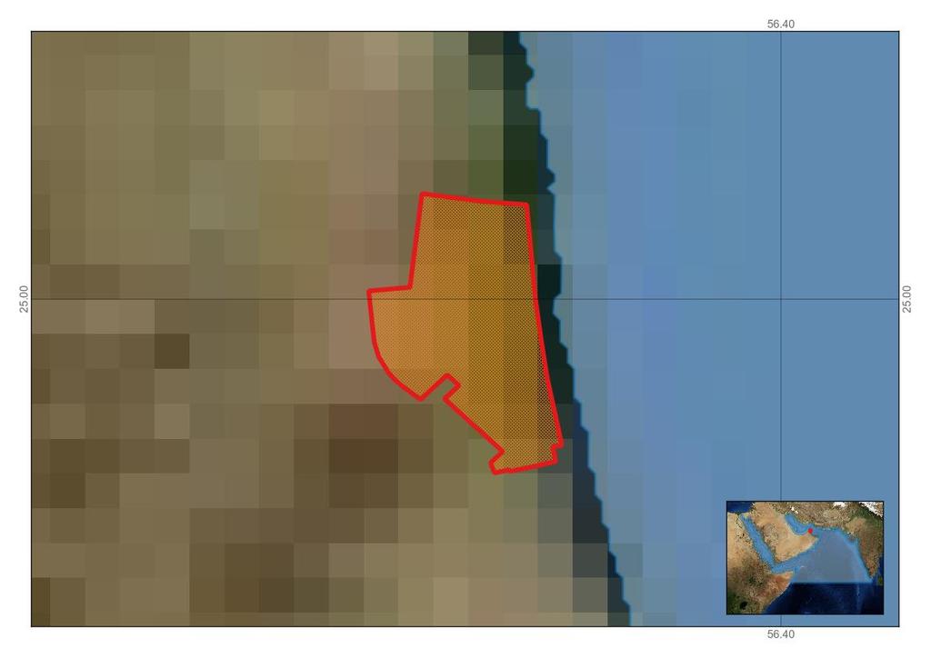
64 Page 64 Figure 2. Kalba Conservation Area
65 Figure 3. Area meeting the EBSA criteria UNEP/CBD/SBSTTA/20/INF/23 Page 65
66 Page 66 Area No. 5: Sir Bu Na air Island Abstract The area is home to more than 300 nesting hawksbill turtles every year (largest nesting population in the United Arab Emirates (UAE) with breeding seabirds that represent more than 1 per cent of the estimated global population and a very healthy coral reef system. Introduction Sir Bu Na air Island is a highly unique island in the Gulf. It is a mixture of mountains with a variety of mineral and sandy beaches with coral reefs extending all the way to the sandy seabed. Between 2010 and 2014, the UAE s Environment and Protected Areas Authority (EPAA) and the Emirates Marine Environmental Group (EMEG) conducted studies on turtles and bird nesting activity, in addition to coral surveys and evaluations. Satellite tagging projects for turtles and sharks were also held on the island by EMEG and EWS-WWF. Location The area is located in the Gulf, 65 km north of Abu Dhabi and 110 km north-west of Sharjah. Feature description of the area The tear-drop shaped island is a salt dome that reaches a peak of 66m almost at the centre of the island. The island contains a variety of minerals, including sulfur, iron oxides and manganese. The area includes marine areas from the shoreline to 35m depth. The area s marine habitats vary between dense coral reefs and sparse coral patches, interspersed by sandy patches filled with benthic species. Fishes and turtles, especially hawksbills (Eretmochelys imbricata), are prominent in the area. Green turtles (Chelonia mydas) and other species have been recorded as well. Hawksbill turtles nest annually in numbers exceeding 300 nests in the whole season cross all beaches with a contemporary record of two green turtle nests, which has never been recorded before in the Gulf. The coral reefs in the area provide a perfect place for fish breeding (including for sharks) as well as foraging areas for turtles. Two species of fishes, the citron clown goby (Gobidon citrinus) and the redcoat squirrelfish (Sargocentron rubrum), were recorded in this area, which are the only records of these species in the Gulf. In addition, six species of corals not recorded anywhere else along the UAE coastline have been recorded in this area. This island is also a breeding site for seabirds (terns and gulls). Sooty gull (Ichthyaetus hemprichii) and bridled tern (Onychoprion anaethetus) breed annually in large numbers; in 2012, 1 per cent of the world population of sooty gull breeds on this island. The island is an annual nesting site for hawksbill turtles, and every year the island holds more than 300 nests. Although this number can fluctuate, it exceeds 300 nests every year. There are also records of green turtle nesting (two nests in 2011 and two attempt of nesting in 2014). Coral reefs in the area are reported to be very healthy without any sign of stress or disease. Further surveys have yet to be undertaken to monitor any update in status (EMEG, 2011). Feature condition and future outlook of the area Since its declaration as a protected area in 2000, a rehabilitation project has been initiated, and surveys began in Turtle monitoring in this area is conducted annually. Surveys are done every year to record number of nests and nesting attempts, and to collect biological data of nesting turtles, and monitor live turtle nesting for any repetitive nesting, if encountered, through a flapper tagging project. This information is inventoried to examine the success rate of the hatchlings (EMEG, 2011).
67 Page 67 Breeding birds are also annually monitored for colony size, clutch size, timing of nesting, hatching, fledging, etc. Abnormality in the nesting activities is also recorded (i.e., mortality, deformation) (EMEG, 2011). Coral monitoring will be conducted in 2015 to re-evaluate the status of the coral reefs, in addition to extensive recording of marine invertebrates and reef fishes (EMEG, 2011). Assessment of the area against CBD EBSA Criteria CBD EBSA Criteria (Annex I to decision I/20) Uniqueness or rarity Description (Annex I to decision I/20) Area contains either (i) unique ( the only one of its kind ), rare (occurs only in few locations) or endemic species, populations or communities, and/or (ii) unique, rare or distinct, habitats or ecosystems; and/or (iii) unique or unusual geomorphological or oceanographic features. Ranking of criterion relevance (please mark one column with an ) No informati on Low Medium High Explanation for ranking Sir Bu Nair is an important marine areas for its unique geological formations, natural flora and marine birds, and is characterized by its sandy beaches that have been used by sea turtles as a center for breeding. It is one of the most important hawksbill nesting sites within the entire Gulf and certainly by far the most important hawksbill nesting site in the UAE (EPPA 2014). Sir Bu Nair Island is characterized by a high level of biodiversity, as a refuge for sea turtles, birds, coral communities, and reef fishes such as one unique fish species (citron goby), 3 rare Gulf fish species, and 6 coral species not recorded along the Gulf coastline in UAE (EPAA 2014). Special importance for lifehistory stages of species Areas that is required for a population to survive and thrive. Explanation for ranking The island is an important nesting site for hawksbill turtles, with more than 300 nests recorded per year (EMEG, 2011); the surrounding waters support the hawksbill rookery during the inter-nesting stages of their lifecycle, as demonstrated by a regional satellite tracking project conducted between 2010 amd 2013 (EWS-WWF, MRF et.al., 2014, Pilcher et.al b). Large populations of sooty gull (Ichthyaetus hemprichii) and bridled tern (Onychoprion anaethetus) annually breed in large numbers; in 2012, 1 per cent of the world population of sooty gull bred on this island (EPAA, 2014).
68 Page 68 Importance for threatened, endangered or declining species and/or habitats Area containing habitat for the survival and recovery of endangered, threatened, declining species or area with significant assemblages of such species. Explanation for ranking As mentioned above, the island and surrounding waters are home to threatened species such as hawksbill turtles (IUCN CR-decreasing), green turtles (IUCN EN-decreasing), sooty gull (IUCN LC decreasing), coral species (endangered with variation) (EPAA Report, 2014). Vulnerabilit y, fragility, sensitivity, or slow recovery Areas that contain a relatively high proportion of sensitive habitats, biotopes or species that are functionally fragile (highly susceptible to degradation or depletion by human activity or by natural events) or with slow recovery. Explanation for ranking Coral reefs are extremely sensitive to human activity (including pollution) and indirect human activities, such as climate change and ocean acidification, which affect marine habitats. Turtle and seabird nesting habitat are extremely sensitive to human presence and disturbance (including noise and light pollution). Marine turtles residing in the Gulf waters experience wide temperature fluctuations and extreme summer temperatures, which exceed, over sustained periods, those found anywhere else across their global range. The Gulf experiences some of the hottest water temperatures in the world during summer months and weekly average sea surface temperatures during this study exceeded 30 o C during a surprising 35.4 per cent of all 168 weeks, with a maximum average weekly temperature of 33.8 o C. Maximum temperatures averaged over each week during this study ranged from 23.0 o C in the winter to 34.9 o C in the summer. (John et al., 1990) Concerns have been raised over sea turtles ability to adapt to elevated ambient temperatures, as projected by climate change scenarios (e.g., Fuentes et al., 2013). Exposure to high temperatures impact many aspects of their biology, including temporal shifts in nesting seasons (del Monte-Luna et al., 2012), as well as their feeding activity and digestion, metabolic rates, growth and physiological maintenance (Bennet and Dawson, 1976). The large body size of marine turtles is generally seen as a contributor to thermal tolerance (Paladino et al., 1990), but adult hawksbills within the Gulf are amongst the smallest in the world, presumably linked to thermal limits and fluctuation rate stressors (Pilcher, 2000). The combination of small body size and elevated temperatures are likely to elevate levels of physiological stress, driving behavioural responses such as those we uncovered in this study (Pilcher et.al. 2014a). One of the key findings of EWS-WWF s Gulf hawksbill project was the discovery of a short-term migration of foraging hawksbill turtles in the Gulf linked to climatic change. This novel finding marked the first step in understanding behavioural changes of sea turtles based on temporary water temperature shifts and is expected to have significant implications on related studies on the effects of climate change on turtle populations in other parts of the world (Pilcher et.al. 2014).
69 Page 69 Biological productivity Area containing species, populations or communities with comparatively higher natural biological productivity. There is insufficient data on biological productivity. Biological diversity Area contains comparatively higher diversity of ecosystems, habitats, communities, or species, or has higher genetic diversity. Explanation for ranking A total of 40 species of coral, such as Psammocora obtusangula, Favites spinosa and Favites acuticollis, have been identified on the island. A total 76 species of reef fishes were recorded during surveys in the northern and western reef areas on the island (EMEG 2014). Gobiodon citrinus, a fish species uncommon in the Gulf, was found on corals in Sir Bu Nair. A large population of breeding sea birds from two species, sooty gull (Ichthyaetus hemprichii) and bridled tern (Onychoprion anaethetus) annually breed in numbers that are large enough that sooty gull in 2012 constituted 1 per cent of the world population of that species. Hawksbill Turtles (Eretmochelys imbricata) are resident, and other turtle species, such as green turtles (Chelonia mydas), have been recorded as well (Report Sharjah, 2012). Naturalness Area with a comparatively higher degree of naturalness as a result of the lack of or low level of human-induced disturbance or degradation. Explanation for ranking The island was declared a protected area in 2000; human activity is extremely limited, thus the island s habitats and scenery have sustained their naturalness (Environment and Protected Areas Authority, 2012). References del Monte-Luna P, Guzmán-Hernández V, Cuevas EA, Arreguín-Sánchez F, Lluch-Belda D (2012). Effect of North Atlantic climate variability on hawksbill turtles in the Southern Gulf of Mexico. Journal of Experimental Marine Biology and Ecology 412: EAD, Marine Environment and Resources of Abu Dhabi. (T. Abdessalaam, ed.). Environment Agency Abu Dhabi. Motivate Publishing, Abu Dhabi. 255 pp. EMEG, Emirates Marine Environmental Group Environment and Protected Areas Authority (EPAA) Report Sharjah, UAE EWS-WWF, Marine Turtle Conservation Project, Final Scientific Report. EWS-WWF, Abu Dhabi, UAE. Fuentes MMPB, Pike DA, DiMatteo A, Wallace BP (2013). Resilience of marine turtle regional management units to climate change. Global Change Biology (2013) 19,

70 Page 70 John VC, Coles SL, AI Abozed A, Seasonal cycles of temperature, salinity and water masses in the Western Arabuan Gulf. Oceanologica Acta 13(3): Paladino FV, O Connor MP, Spotila JR Metabolism of leatherback turtles, gigantothermy, and thermoregulation of dinosaurs. Nature 344: Pilcher, N.J., The hawksbill turtle Eretmochelys imbricata in the Arabian Gulf. Chelonian Conservation Biology 3(2): Pilcher, N.J., Aspects of the Biology and Early Life Stage Survival of Sea Turtles. (PhD Thesis) Southern Cross University, Lismore, NSW, pp Pilcher, N.J., The green turtle (Chelonia mydas) in the Saudi Arabian Gulf. Chelonian Conservation & Biology 3: Pilcher, N.J., et. al., 2014a. Short-term behavioral responses to thermal stress by hawksbill turtles in the Arabian region. J. Exp. Mar. Biol. Ecol., 457 (2014), pp Pilcher, N.J., et al., 2014b. Identification of Important Sea Turtle Areas (ITAs) for hawksbill turtles in the Arabian Region. J. Exp. Mar. Biol. Ecol., 460 (2014), pp Report Sharjah, May 2012 EPAA Maps and Figures

71 Page 71 Figures 1 and 2. Typical inter-nesting, migratory, foraging behaviour of hawksbill turtles tracked as part of the regional tracking project in the Gulf (EWS-WWF, MRF et al. 2014). Figure 3. Area meeting the EBSA criteria Rights and permissions Any use of the satellite tracking information generated from the regional satellite project for hawksbills should refer to the relevant reports published by EWS-WWF and the project Scientific Advisor, Nick J. Pilcher (MRF).
72 Page 72 Area no. 6: Sulaibikhat Bay Abstract The area covers critical habitats in the Gulf, such as coral reefs, mangroves, seagrass and algal beds. These habitats have received most scientific attention due to their biological productivity, provision of nutrients and high biodiversity. Microbial mats associated with the vast areas of intertidal flats of Sulaibikhat Bay (Kuwait Bay) contribute far more to intertidal productivity than other sources, particularly in the absence of seagrass and mangroves. Microbial mats are important in the dynamics of intertidal and subtidal regions of Sulaibikhat Bay, supporting a wide variety of intertidal and subtidal macrofauna. In Sulaibikhat Bay alone they form the base of the food web for 82 macrofaunal species, 49 of which occur within the accessible upper intertidal region (14 crustaceans, 2 molluscs, 1 sipunculoid, 8 fish species and 24 avian species) and 33 subtidal fish and shellfish species, of which several are known to visit the intertidal region during high tide. Introduction At its North-West end, the Gulf receives its major source of freshwater input and associated nutrients from the Tigris, Euphrates and Karun Rivers via Shatt Al-Arab, with an estimated annual freshwater inflow ranging between 5x10 (Grasshoff, 1976) and 2x10m 3 (Hadi et al., 1984) of nutrient- rich water per year. Kuwait is a part of the Gulf region and is located within the north-west corner of the Gulf, between latitudes 28 o 30 and 30 o 06 North, and longitudes 46 o 30 and 49 o 00 East. The northern region of Kuwait is considered part of the Tigris-Euphrates delta, which receives sediments carried from the Shatt Al-Arab riverine system (Kassler, 1973); the sediments along the Kuwaiti coast vary in size from silt and clay to large boulders. Clean medium-grade sand beaches prevail along the open coast of Kuwait City, extending down to the Saudi Arabia border, but never reach the level of exposure seen on oceanic shores. On the northern coast (Kuwait Bay) soft sediment shores prevail and are graded from mud to muddy sand predominated by silt and clay. These types of sediment originally come from the Shatt Al-Arab estuary. Generally, carbonate sediments predominate in the south; while land-derived clastics dominate in the north. Some of the most extensive intertidal mudflats occur around Kuwait Bay, particularly at Dawhat Kazima, at the west end of the Bay, and in Sulaibikhat Bay, on the south-west side. The intertidal mudflats have been identified worldwide as an important marine habitat and ecosystem. These areas are well recognized to harbour an immense diversity of organisms and to support a very high biomass. Recently the intertidal mudflats have received an intense attention by the developed countries due to their contribution to primary productivity of marine ecosystems. Many studies have revealed intertidal mudflats to be one of the most productive habitats emanating from the benthic microbial mat complex. The latter, which include the benthic microalgae and benthic diatoms, are shown to be a major food source for benthic feeders such as ciliates, shrimps and other crustaceans, molluscs and annelids. They are revealed to be ecologically significant in the coastal marine environment. In contrast, many other countries, including developing ones, have treated these tidal flats as coastal wastelands, where they have been subjected to intensive land reclamation associated with the rapid modification of the coastline. Such action will have negative consequences on these unique habitats, biota and the marine ecosystem as whole. More recently, microbial mats associated with vast areas of the Gulf intertidal mudflats have been suggested to contribute far more to intertidal productivity than other resources (Price et al., 1993). This is true for Kuwait, where mangroves are virtually nonexistent (Jones, 1986). Location Sulaibikhat Bay - Kuwait Bay, with a position at E, N.

73 Page 73 Feature description of the proposed area Kuwait has extensive mudflat habitats occurring along the northern parts of Kuwait coast, particularly in Kuwait Bay. These intertidal mudflats have been relatively poorly studied in all aspects of marine resources, including tracing their role in the food web, in comparison with other intertidal habitats worldwide. Sulaibikhat Bay covers an area of approximately 70 km 2. It is bound to the north-west by Ras-
74 Page 74 Ushairij, and by Ras Ajuza to the south-east. The ambient temperature of Sulaibikhat Bay is characterized by large annual fluctuations ranging from between 12.5 o C to 35 o C (Anon., 1983). Microbial mats are important in the dynamics of intertidal and subtidal regions of Sulaibikhat Bay, supporting a wide variety of intertidal and subtidal organisms, reflecting its unique marine ecosystem. Cyanobacteria and microbenthose, which dominate the coarser grained top shore sediments, have been suggested as an important source of primary productivity, supplying dense population of gastropods and other faunal communities (Sheppard et al.1992). Halophytes Halocnemon strobilaceum and Salicornia herbacea (europea) are the major vascular plants found along the mudflats of Sulaibikhat Bay; distribution and abundance of these halophytes vary within the bay. The fastest growth rate of Halocnemon plant individuals occurs from July to September, and flowering occurrs from October to November, when they start to produce red to purple fruiting spikes. During December, the plants progressively turn completely to woody bush. The plant ground forms as a refuge for many insects and burrowing chordates. The annual increase in organic content of this plant was ±3.22 per cent of dry weight. The Salicornia community A occupies the lowest limit of the upper shore, where the substratum is always invested by numerous brachyuran and mudskipper burrows. This growth rate and abundance varies through the year due to physical seasonal variations in the bay. These plants eventually provide food for large members of herbivorous macrofauna. Alternatively, they enter the detritus food chain and become readily available to many detritivorous macrofauna. The most dominant species of macroalgae are the green algae, which include ulva lactuca, Enteromorpha compressa, E. intestinalis, E. flexuosa, E. intestinalis, Cladophora sp., Bryopsis hypnoides, while a few species of brown algae also wash inshore, such as Colpomenia sinuosa, Padina boryana, Lithothumnium sp. and Sargassum binderi. A smaller number of species of red algae also wash ashore, including Ceratium sp. Polysiphonia sp. and Hypnea sp. These macroalgae occur as a thick layer on the surface of intertidal mudflats for a short period of time, particularly at the upper littoral zone. This layer is often grazed upon by herbivorous invertebrates, such as Cerethidea cingulata. The abundance of macroalgae varies at different sites within the bay. Phytoplankton is the primary producer of the open sea, and is a temporary part of the shore ecosystem when the tide is in. On muddy shores, where the tide ebbs quietly, some of the phytoplankton gets stranded on the mud and may contribute to the productivity while the tide is out. These members are predominantly diatoms. The microphytobenthos community, made up of diatoms, cyanobacteria and euglenoids, plays a key role in tidal flat dynamics in estuaries. The cycling of microalgae, both within tidal flats and between the tidal flats and overlying water column, has considerable importance both for benthic and pelagic herbivores, and in modifying sediment dynamics. Zooplankton is the direct link in the pelagic system between the primary producers phytoplankton and the consumers the fish. Grazing on phytoplankton, zooplankton play a very important role in the circulation of nutrients and organic matter and thus in self-purification of the ecosystem. Representatives of almost all the major phyla have been identified in the zooplankton community. Keeping in mind the position and importance of zooplankton in the food web, 48 taxonomic groups have been identified. Measurements of zooplankton biomass in Kuwaiti waters have been reported to range from 144mg/m 3 to 861mg/m 3 dry weight, using a 110 m and 333 m mesh net (Michel et al., 1986). This is very high when compared to ranges of other areas worldwide. Frequently abundant macrofauna species in the area include the ocypodid crab Leptochryseus kuwaitense, which is endemic to Kuwait, and the molluscan bivalve Protape core, the grapsid crab Metapograpsus messor, an inhabitant of mangrove/rocky habitats, sipunculid worm, Ikeda taenoides, the ghost shrimp Alpheus sp. and molluscan bivalves Amiantis umbonella, razer blade bivalve, Solen sp., crabs, Manningis
75 Page 75 arabicum and Uca annulipes albimana, ocypodid crabs: Tylodiplax indica, Ilyoplax stevensi, Macrophthalmus depressus, Macrophthalmus dentipes, Eurycarcinus orientalis, mudskippers: Periophthalmus waltoni and Boleophthalmus boddarti, Periophthalmus koelreuteri and Acentrogobius ornatus. The goby Boleophalmus boddarti population occasionally construct circular territorial walls that retain water as well as benthic microalgae after the ebbing of the tide. Twenty one (21) fish species of different taxa have been collected and identified, including: Eurycarcinus orientalis, Portunus pelagicus, Metaplax indica, Macrophthalmus pectinipes, Metapenaeus affinis, Periophthlmus waltoni, Boleophthlamus boddarti, Acentrogobius ornatos, Nasima dotilliformis, Tylodiplax indica, Macrophthlamus depressus, Sillago sihama, Periophthalmus koelreuteri, Uca sindensis, Ilyoplax stevensi, Thryssa whiteheadi, Penaeus semisulcatus, Liza macrolepis, Euryglossa orientalis, Arius tinbilineatus and Arius tinbilineatus. Sulaibikhat Bay has a high abundance and biodiversity of seabirds. The greater pink flamingo Phoenicopterus ruber is the most dominant seabird in the Bay. This bird has been observed in numbers reaching approximately 443. The second-most dominant species is the common seagull, Larus canus. Other species include: The Little stint, Calidris minuta, sand piper Actitis hypoleucos, and grey heron Ardea cinerea and little egret Egretta garzetta have been frequently encountered along the bay, although their number varies from one transect to another. Others were occasionally observed to occur along the mudflat transects. Such species include the curlew Numenius arquata, the avocet Recurvirosta avosetta, little ringed plover Charadrius dubius, ringed plover C. hiaticula and C. alexandrinus as well as March sandpipper Tringa stagnatilis and common tern Sterna hirundo. In general, the intertidal mudflats of Sulaibikhat Bay have been used as refuge sites for a wide range of diverse seabirds. Many seabirds use these sites as permanent habitat throughout the year. Other species visit the mudflat habitat of Sulaibikhat Bay as temporary stations for refuelling and resting during their migratory route to their final destination. Hence, these sites, characterized by biota richness, attract such a large diversity of seabirds. Feature condition and future outlook of the proposed area Sulaibikhat Bay is unique due to its biodiversity harbouring endemic species supporting a high abundance of faunal species. This, coupled with the fact that the fauna it supports relies most heavily on a locally produced carbon source, represented by microbial mats (with the operation of isotopic fractionation in the food webs), makes it a vitally important habitat. Declines in algal biomass could be due to a range of factors, such as nutrient limitation, consumption by grazers, desiccation or dislocation by adverse weather conditions (Al-Mohanna et al. 2007). Watermann et al. (1999) reported that beside grain size, temperature is also an important limiting factor for the microbial mat growth. The intertidal mudflats frequently experience a much wider range of temperature than the other habitats. This is due, in part, to their relatively large surface area/volume ratios, thus allowing heating and cooling more rapidly under prevailing atmospheric conditions (Boaden and Seed, 1996). Recent work gives indication that the bay is undergoing several alterations associated with urbanization and industrialization, reducing the biodiversity in the area. Anthropogenic activities, such as infilling reclamation and construction of sewage outlets, have modified most of the coast since the mid 1980s, leaving a minimal strip of pristine mudflat affecting its marine inhabitants. Assessment of the area against CBD EBSA Criteria CBD EBSA Description Criteria (Annex I to decision I/20) (Annex I to decision I/20) Ranking of criterion relevance (please mark one column with an ) No informat ion Low Medi um High
76 Page 76 Uniqueness or rarity Area contains either (i) unique ( the only one of its kind ), rare (occurs only in few locations) or endemic species, populations or communities, and/or (ii) unique, rare or distinct, habitats or ecosystems; and/or (iii) unique or unusual geomorphological or oceanographic features. Microbial mats are important in the dynamics of intertidal and subtidal regions of Sulaibikhat Bay, supporting a wide variety of intertidal and subtidal macrofauna, contributing far more to intertidal productivity than other sources, particularly in the absence of seagrass and mangroves. In Sulaibikhat Bay alone, they form the base of the food web for 82 macrofaunal species, 49 of which occur within the accessible upper intertidal region (14 crustaceans, 2 molluscs, 1 sipunculoid, 8 fish species and 24 avian species) and 33 subtidal fish and shellfish species. Halophytes Halocnemon strobilaceum and Salicornia herbacea (europea), ocypodid crabs: Tylodiplax indica, Ilyoplax stevensi, Macrophthalmus depressus, Macrophthalmus dentipes, Eurycarcinus orientalis, mudskippers: Periophthalmus waltoni and Boleophthalmus boddarti, Periophthalmus koelreuteri and Acentrogobius ornatus. The greater pink flamingo Phoenicopterus ruber, The little stint, Calidris minuta, sandpiper Actitis hypoleucos, grey heron Ardea cinerea and little egret Egretta garzetta. Special Areas that are required for a population to importance survive and thrive. for lifehistory stages of species The marine food web for this area shows the importance of the species survival and availability for the different organisms, acting as an important nursery ground for various shrimp and fish species within Kuwait Bay (Al-Mohanna et al. 2004). Microbial mats are mainly composed of diatoms and cyanobacteria (approx. 70 and 30 per cent, respectively). Cyanobacteria and microbenthose, which dominate the coarser grained top shore sediments, have been suggested as an important source of primary productivity, supplying dense populations of gastropods and other faunal communities (Sheppard et al.1992). Importance for threatened, endangered or declining species and/or habitats Area containing habitat for the survival and recovery of endangered, threatened, declining species or area with significant assemblages of such species. A direct link to the support of key local fisheries, underlining the necessity for conservation of these mudflats (Al-Zaidan et al. 2006). Copepods are the most abundant in the zooplankton community of Sulaibikhat Bay. The early larval fish stages as well as the adult stages of fishes feed on them. Hence they form a vital link to economically important fishes such as silver/white pomfret, or zobaidy (Pampus argenteus) and suboor (Tenualosa illisha). Although some intertidal species feeding on the mats are not commercially important, they serve as food for many species that are commercially important (Al- Mohanna et al. 2004). Vulnerability, fragility, Areas that contain a relatively high proportion of sensitive habitats, biotopes or species that
77 Page 77 sensitivity, or slow recovery are functionally fragile (highly susceptible to degradation or depletion by human activity or by natural events) or with slow recovery. Declines in algal biomass could be due to a range of factors, such as nutrient limitation, consumption by grazers, desiccation or dislocation by adverse weather conditions (Al-Mohanna et al. 2007). Watermann et al. (1999) reported that beside grain size, temperature is also an important limiting factor for the microbial mat growth. The intertidal mudflats frequently experience a much wider range of temperature than the other habitats. This is due, in part, to their relatively large surface area/volume ratios, thus allowing heating and cooling more rapidly under prevailing atmospheric conditions (Boaden and Seed, 1996). Biological productivity Area containing species, populations or communities with comparatively higher natural biological productivity. Growth rate and variation of various shrimp, fish, crab species and availability of both fish larva and fish eggs indicate high productivity of the area. Marine food web for this area showed the importance of the species survival and availability for the different organisms in this area. Important nursery ground for various shrimp and fish species in Kuwait bay. Microbial mats were mainly composed of diatoms and cyanobacteria (approx. 70 and 30 per cent, respectively). Cyanobacteria and microbenthose dominate the coarser grained top shore sediments and have been suggested as an important source of primary productivity, supplying dense populations of gastropods and other faunal communities (Sheppard et al.1992). Developmental stages of commercially important fishes and shellfishes form a part of the zooplankton community (Al-Mohanna et al. 2004). Biological diversity Area contains comparatively higher diversity of ecosystems, habitats, communities, or species, or has higher genetic diversity. Species diversity is well documented in the area, indicated by the primary producer level, both benthic and pelagic, with diversity in consumer levels (Al-Mohanna et al. 2004). Microbial mats contribute to the area s exceptional biodiversity, abundance and biomass of species. Sulaibikhat Bay is a unique entity due to its biodiverse nature, harbouring endemic species supporting high abundance of faunal species (Al- Mohanna et al. 2004). Naturalness Area with a comparatively higher degree of naturalness as a result of the lack of or low level of human-induced disturbance or degradation. Recent work indicates that the bay is undergoing several alterations associated with urbanization and industrialization, reducing the biodiversity in the area (Al-Mohanna et al. 2004). References Al-Mohanna S.Y., Jones D.A., Subrahmanyam M.N.V., George P., (2004) The Role of Microbial Mats in The Arabian Gulf Ecosystem- Final report- Project No.EZ0011- Environment Public Authority of Kuwait. Al-Mohanna S.Y., George P., Subrahmanyam M.N.V. (2007) Benthic microalgae on a sheltered intertidal mudflat in Kuwait Bay of the Northern Arabian Gulf. J. Mar. Biol. Ass. India, 49 (1):
78 ABUNDANCE (%) UNEP/CBD/SBSTTA/20/INF/23 Page 78 Al-Zaidan A.S.Y., Kennedy H., Jones D.A, Al-Mohanna S.Y., (2006) Role of microbial mats in Sulaibikhat Bay (Kuwait) mudflat food webs: evidence from δ C analysis. Marine Ecology Progress Series, 308: Maps and Figures BACILLAROPHYCEAE (CENTRALIS) JAN FEB MAR APR MAY JUN JUL AUG SEPT OCT NOV DEC MONTHS Bacteriastrum varians Biddulphia mobiliensis Chaetoceros affinis C. curvisetus Chaetoceros pelagicus Coscinodiscus centralis Coscinodiscus excentricus Ditylum brightwellii Lauderia annulata Leptocylindrus danicus Melosira moniliformis Planktoniella sol Rhizosolenia alata Rhizosolenia stolterfothii Thalassiosira decipiens Skeletonema costatum Cyclotella meneghiniana Figure 1. Distribution of different species belonging to class Bacillariophyceae (Centralis) in Sulaibhikat Bay.
79 Abundance (%) ABUNDANCE (%) UNEP/CBD/SBSTTA/20/INF/23 Page 79 BACILLARIOPHYCEAE (PENNALES) JAN FEB MAR APR MAY JUN JUL AUG SEPT OCT NOV DEC MONTHS Amphiprora gigantea Amphora lineolata Asterionella japonica Bacillaria paradoxa Diploneis weissflogii Gyrosigma balticum Navicula longa Nitzschia closterium N. grunowii Nitzschia paleo Nitzschia seriata Pleurosigma elongatum Thalassionema nitzschioides Thalassiothrix frauenfeldii Nitzschia longissima Figure 2. Distribution of different species belonging to class Bacillariophyceae (Pennales) in Sulaibhikat Bay. 100% 80% 60% 40% 20% 0% Jan Feb Mar Apr May Jun Jul Aug Sept Oct Nov Dec Months Eurycarcinus orientalis Portunus pelagicus Metaplax indica Macrophthalmus pectinipes Metapenaeus affinis Periophthlmus waltoni Boleophthlamus boddarti Acentrogobius ornatus Nasima dottilliformis Tylodiplax indica Macrophthlamus depressus Sillago sihama Periophthalmus koelreuteri Uca sindensis Ilyoplax stevensi Thryssa whiteheadi Penaeus semisulcatus Liza macrolepis Euryglossa orientalis Arius tinbilineatus Figure 3. Per cent frequency abundance of macrofauna collected by fish traps from January to December in different sites of Sulaibikhat Bay
80 Abundance UNEP/CBD/SBSTTA/20/INF/23 Page JAN FEB MAR APR MAY JUN JUL AUG SEPT OCT NOV DEC Months Phoenicopterus ruber (Greater Flamingo) Egretta garzetta (Little egret) Himantopus himantopus (Black winged stilt) Charadrius dubius (Little ringed plover) Charadrius alexandrinus (Kenttish plover) Calidris alba (Sanderling) Limosa lapponica (Bar tailed Godwit) Tringa nebularia (Greenshank) Larus canus (Common sea gulls) Ardeola ralloides (Squacco heron) Aquilla sp- Eagle Sarciophorus tectus (Black head plover) Phalacrocorax carbo (Cormorant) Ardea cinerea (Grey heron) Recurvirosta avosetta (Avocet) Charadrius hiaticula (Ringed plover) Actitis sp (Hypoleucos common sandpiper) Calidris minuta (Little stint) Numenius arquata (Curlew) Tringa sp (Stagnatilis marsh sandpiper) Sterna hirundo (Common tern) Ardea purpurea (Purple heron) Phalacrocorax africanus (Long tailed cormorant) Tadorna tadorna (Common shelduck) Figure 4. Mean abundance of seabirds in Sulaibikhat Bay during the 12-month sampling period


81 Page 81 Figure 5. Schematic distributions of primary producers and consumers along the mudflats of Sulaibikhat Bay (stable carbon isotopes). Figure 6. Commercial shellfish (Metapenaeus affinis and Portunus pelagicus) and fish species along the intertidal mudflat of Sulaibikhat Bay (growth variation indicating breeding grounds).


82 Page 82 Figure 7. Left: Periophthalmus waltoni Right: Boleophthalmus boddarti distinctive walled homes. Figure 8. Area meeting the EBSA criteria Rights and permissions - Prof. Salim Al-Mohanna Kuwait University- Faculty of Science, drsalim474@gmail.com. - Dr. Abdullah Al-Zaidan Environment Public Authority of Kuwait, alzaidan.abdullah@gmail.com
83 Page 83 Area no. 7: Qaro and Umm Al-Maradem Abstract This area hosts 35 recorded species of Scleractinian corals from 12 families, with 27 species being hermatypic and eight species ahermatypic, and is considered to be important habitat for diverse species. Fish is the most diverse group of vertebrates found in the coral reefs, with a total of 124 recorded species. These reefs also offer a breeding site for turtles and provide food for species like seabirds and dolphins. The coral reef community suffers harsh environmental conditions, such as high temperatures and high salinity, which can affect the number of coral species in the area. Introduction Coral reef ecosystems are globally important and have a wide range of natural ecological, economic and cultural values. These reefs are major centres of marine biodiversity, providing essential habitats for many thousands of different species of algae, corals, worms, molluscs, crustaceans, fish and other marine organisms. Kuwait s coral reefs provide habitats for commercially important fish species and are of international scientific interest because they flourish in environmental conditions previously believed to be too extreme to allow corals to survive (high temperatures and high salinities). In addition, the remarkable survival of Kuwait s coral reefs, following the massive Gulf War oil spills in 1991, was documented by several international scientific expeditions. Pioneering surveys on Kuwait s reefs identified one species of coral new to science (Hodgson and Carpenter, 1995). These reefs may also play important roles in providing larvae, which could disperse to other corals reefs within the Gulf, especially the islands located in the southern part of Kuwait (Qaro and Umm Al-Maradem). The southern islands, which include Umm Al-Maradem and Qaro, have the best developed reefs, which have sand islands present, known as coral cays. Thirty-five species of Scleractinian corals have been identified from 12 families, with 27 species being hermatypic (reef building) and eight species ahermatypic. There is one endemic species found in the Gulf: Acropora arabensis (Carpenter et al., 1997; Harrison, pers. com.). Location Qaro Island with a location of E and N; Umm Al-Maradem Island with a location of E and N. Feature description of the proposed area Coral reefs are largely restricted to the southern area of Kuwait and include a range of offshore platforms and smaller patch reefs, and nearshore patch reefs and fringing coral assemblages along the southern coastline. All reefs occur in relatively shallow water, with significant coral development restricted to reef areas above a depth of 15m, and greatest coral growth and diversity above a depth of 10m. Umm Al- Maradem is the southernmost and largest island, and has an extensive reef system. The island is partly vegetated and is about 550m long. It is surrounded by beach rock and a sandy beach, which extends as an elongated sand spit from the southwest of the island. The reef is about 1.4 km long and up to 1.1 km wide. The reef flat is dominated by living and dead massive Porites corals, with patches of other corals, including small colonies of branching Acropora and Stylophora. Umm Al-Maradem is a popular destination for boating, fishing and diving, and tends to have reduced cover of fragile branching corals compared with Qaro reef, which is located further offshore and is less frequently visited. Qaro is the smaller island and is not vegetated. The oblong-shaped sandy cay is about 200 m long and is located in the centre of an elliptical platform reef that extends up to 550 m from the island. The reef is about 1.3 km long and up to 600 m wide. Qaro reef is one of the most diverse and visually attractive coral reefs in Kuwait. The extensive reef flat is dominated by branching and table Acropora colonies and massive Porites. The cover of living corals can be very high, with 81 per cent live coral cover recorded at
84 Page 84 some reef flat sites. About 50 m south of the island, the reef flat community is dominated by very large plate and branching Acropora, some of which are more than 4 m in diameter. The reef flat community includes a wide range of other corals and diverse assemblages of fish and other reef organisms, and the adjacent reef slope is likely to be hundreds of years old. A wide variety of other invertebrate and vertebrate animals occur on Kuwait s reefs; however, the diversity, abundance and ecology of most of these animals have not been studied. The invertebrates include a range of sponges, zoanthids and other cnidarians, worms, molluscs, crustaceans and echinoderms, although few species are common or obvious components of these reef communities. Echinoderms are the most prominent mobile invertebrates on Kuwait s reefs. The black reef-boring sea urchin Echinometra mathaei is the most abundant urchin species, with average densities of 20 to 80 urchins per square metre of reef recorded at Qaro, Kubbar and Umm Al-Maradem reefs (Dorning and Roberts, 1993). The long-spined sea urchin Diadema setosum is relatively common and is often observed aggregated in small groups under coral overhangs during daylight. The importance of grazing activities and bioerosion by this species has not been determined. Another echinoderm, such as crown-of-thorns starfish (Acanthaster planci), is a major coral predator on some coral reefs in Oman (Coles, 1996). Fish are the most diverse and important groups of vertebrate animals on coral reefs, and play essential ecological roles in reef communities. A total of 124 species representing 51 families of fish have been recorded on Kuwait s coral reefs. Damselfish, such as Chromis xanthoptergia and Neopomacentrus sindensis, are among the most abundant fish on Kuwait s reefs and form large schools near corals. Some of the fish species associated with the coral reef community of the southern islands include sharks and rays: Chiloscyllium arabicum, Stegastoma varium, Carcharhinus dussumieri, Torpedo sinuspersici, Himantura uarnak, Taeniura meyeni, Aetobatis narinari; eels: gymnomuraena zebra, Gymnothorax undulates; bony fish: Plotosus lineatus, Synodus variegates, Austrobatrachus dussumieri, Antennarius nummifer, Tylosaurus crocodiles, Hyporhamphus sindensis, Doryrhamphus excisus excises, Pterois miles, Scorpaenopsis barbatus, Tuberculated flathead, Cephalopholis hemistiktos, Epinephelus coioides and Pseudochromis aldabraensis. Kuwait s reefs represent the northernmost breeding habitats for endangered marine turtles in the western Gulf. Green turtles, Chelonia mydas, and hawksbill turtles, Eretmochelys imbricata, are occasionally seen around reeds and turtles have been recorded nesting on the sand cays at Qaro, Umm Al-Maradem and possibly Kubbar. Other vertebrates, such as seabirds and dolphins, feed on the abundant fish resources in the vicinity of coral reefs. Feature condition and future outlook of the proposed area The harsh and extreme marine environmental conditions in Kuwait are near the limits for most coral species. The high and low temperatures, the high salinities, high sedimentation rates, high turbidity because of sediment loads and natural hydrocarbon seeps all act as stressors that limit the number of coral species found in the area. The species that do occur in the area are relatively tolerant and show a remarkable resilience for the varied conditions experienced (Carpenter et al. 1997). Temperature extremes appear to be significant for shallow water reef flat communities, where thermal stress can limit the upward growth and development of corals. Sediment and water turbidity can limit coral growth as well. Sediment can abrade and smother corals; they use a significant amount of energy to remove sediment from the surface of their living tissues. Elevated salinity, on the other hand, is due to the discharge of low salinity water from Shatt Al-Arab, and high rates of evaporation lead to higher than normal salinity levels in the Gulf region. Increases in turbidity decrease penetration of light into the sea, thus reducing photosynthesis by the coral zooxanthellae and other reef algae (Carpenter et al. 1997). Corals have adapted to survive in these especially harsh conditions. The region contains complex and unique coral
85 Page 85 reefs with relatively low biological diversity, but with many endemic species. Large parts of the region are in a pristine state, but there are increasing environmental threats from habitat destruction, overexploitation and pollution. Coral cover is generally low, with evidence of recent, widespread coral mortality. There were two major coral bleaching events, one in the summer of 1996 and another more severe case in the summer of 1998, which led to an average of around 50 per cent coral mortality experienced in Kuwait. Other important natural limiting factors include intense grazing pressure by sea urchins and other bioeroders, which can physically damage corals (Carpenter et al. 1997). The natural dynamism of Kuwait s reef communities makes it difficult to fully assess the impacts of human-induced disturbance and pollution. However, a number of human activities are clearly damaging these reefs. The reduced cover of branching and plate corals at Umm Al-Maradem reefs may be related to the high visitation rates at these reefs. The major anthropogenic threats are land-filling and dredging of the reefs for coastal development, anchor damage from boats, discharges from industrial and desalination facilities (Wilkinson, 2000). Boat anchors are often dropped directly onto corals, which causes fragmentation or destruction of the more delicate branching and plate corals, thereby breaking and overturning coral colonies over large areas of the reef. Much of the broken coral ends up dying and collecting as dead coral rubble (Carpenter, 1997). Assessment of the area against CBD EBSA Criteria CBD EBSA Criteria (Annex I to decision I/20) Uniqueness or rarity Description (Annex I to decision I/20) Area contains either (i) unique ( the only one of its kind ), rare (occurs only in few locations) or endemic species, populations or communities, and/or (ii) unique, rare or distinct, habitats or ecosystems; and/or (iii) unique or unusual geomorphological or oceanographic features. Ranking of criterion relevance (please mark one column with an ) No informat ion Low Medi um High Explanation for ranking The species found on the islands are rare and restricted to these areas. The reef flat is dominated by Porites corals (Porites harrisoni and Porites lutea), with patches of other corals, including Acropora (Acropora clathrata and Acropora arabensis) and Stylophora (Carpenter et al., 1997; Harrison, pers. com). The black reef-boring sea urchin Echinometra mathaei is the most abundant urchin species. A total of 124 species representing 51 families of fish have been recorded on Kuwait s coral reefs. The fish species associated with the coral reef community of the southern islands include damselfish (e.g., Chromis xanthoptergia and Neopomacentrus sindensis), sharks and rays (Chiloscyllium arabicum, Stegostoma varium, Carcharhinus dussumieri, Torpedo sinuspersici, Himantura uarnak, Taeniura meyeni and Aetobatus narinari), eels (Gymnomuraena zebra, Gymnothorax undulates) and bony fish (Plotosus lineatus, Synodus variegatus, Austrobatrachus dussumieri, Antennarius nummifer, Tylosurus crocodilus, Hyporhamphus sindensis, Doryrhamphus excisus excises, Pterois miles, Scorpaenopsis barbatus, Tuberculated flathead, Cephalopholis hemistiktos, Epinephelus coioides, Pseudochromis aldabraensis (Carpenter et al., 1997; Harrison, pers. com.). Special importance Areas that are required for a population to survive and thrive.
86 Page 86 for lifehistory stages of species Explanation for ranking The islands offer a breeding site for green turtles, Chelonia mydas. Both green turtles and hawksbill turtles, Eretmochelys imbricata, are occasionally seen around reeds and have been recorded nesting on the sand cays at the islands (Carpenter et. al, 1997). Importance for threatened, endangered or declining species and/or habitats Area containing habitat for the survival and recovery of endangered, threatened, declining species or area with significant assemblages of such species. Explanation for ranking Green turtles are endangered, according to the IUCN Red List, and are found to be located on these islands. They migrate from the northern part to the southern islands to escape human activities, and these sites are the favoured nesting grounds for green turtles in the southern part of Kuwait. Vulnerability Areas that contain a relatively high proportion, fragility, of sensitive habitats, biotopes or species that sensitivity, or slow recovery are functionally fragile (highly susceptible to degradation or depletion by human activity or by natural events) or with slow recovery. Explanation for ranking Coral reefs in this area are vulnerable to high and low temperatures, high turbidity and sedimentation, and elevated salinity. Temperature extremes appear to be significant for shallow water reef flat communities, where thermal stress can limit the upward growth and development of corals. Sediment and water turbidity can limit coral growth as well. Sediment can abrade and smother corals; they use a significant amount of energy to remove sediment from the surface of their living tissues. Elevated salinity, on the other hand, is due to the discharge of low salinity water from Shatt Al-Arab, and high rates of evaporation lead to higher than normal salinity levels in the Gulf region. Increases in turbidity decrease penetration of light into the sea, thus reducing photosynthesis by the coral zooxanthellae and other reef algae. Water exchange is restricted in the Gulf region, which means the waters become highly saline because of high evaporation and low inputs of fresh water (Carpenter et al. 1997). Corals have adapted to survive in these especially harsh conditions. The region contains complex and unique coral reefs with relatively low biological diversity, but with many endemic species. Large parts of the region are in a pristine state, but there are increasing environmental threats from habitat destruction, over-exploitation and pollution. Coral cover is generally low, with evidence of recent, widespread, coral mortality. There were two major coral bleaching events, one in the summer of 1996 and another more severe case in the summer of 1998, which led to an average of around 50 per cent mortality experienced in Kuwait. Other important natural limiting factors include intense grazing pressure by sea urchins and other bioeroders, which can physically damage corals. The black reef-boring sea urchin Echinometra mathaei is the most abundant urchin species (Carpenter et al. 1997). Biological productivity Explanation for ranking Area containing species, populations or communities with comparatively higher natural biological productivity.
87 Page 87 The coral reef community offers food and habitat for many organisms. Green turtles, Chelonia mydas, and hawksbill turtles, Eretmochelys imbricata, are occasionally seen around reeds, and turtles have been recorded nesting on the sand cays at the islands. Other vertebrates, such as seabirds and dolphins, feed on the abundant fish resources in the vicinity of coral reefs (Carpenter et al. 1997). Biological diversity Area contains comparatively higher diversity of ecosystems, habitats, communities, or species, or has higher genetic diversity. Explanation for ranking The coral reef communities on these islands offer a wide range of diverse species, including vertebrates and invertebrates. Thirty-five species of Scleractinian corals from 12 families have been recorded, with 27 species being hermatypic (reef-building) and eight species ahermatypic. There is one endemic species found in the Gulf: Acropora arabensis (Carpenter et al., 1997; Harrison, pers. com.). The reef flat is dominated by Porites corals (Porites harrisoni and Porites lutea), with patches of other corals, including Acropora (Acropora clathrata and Acropora arabensis) and Stylophora (Carpenter et al., 1997; Harrison, pers. com). The black reef-boring sea urchin Echinometra mathaei is the most abundant urchin species. A total of 124 species representing 51 families of fish have been recorded on Kuwait s coral reefs. The fish species associated with the coral reef community of the southern islands include damselfish (e.g., Chromis xanthoptergia and Neopomacentrus sindensis), sharks and rays (Chiloscyllium arabicum, Stegastoma varium, Carcharhinus dussumieri, Torpedo sinuspersici, Himantura uarnak, Taeniura meyeni, Aetobatis narinari), eels (Gymnomuraena zebra, Gymnothorax undulates) and bony fish (Plotosus lineatus, Synodus variegatus, Austrobatrachus dussumieri, Antennarius nummifer, Tylosurus crocodilus, Hyporhamphus sindensis, Doryrhamphus excisus excises, Pterois miles, Scorpaenopsis barbatus, Tuberculated flathead, Cephalopholis hemistiktos, Epinephelus coioides, Pseudochromis aldabraensis). Naturalness Area with a comparatively higher degree of naturalness as a result of the lack of or low level of human-induced disturbance or degradation. Explanation for ranking Human disturbance does occur on these islands, and fishing and boating affect the reef and fishes in the area. The reduced cover of branching and plate corals at Umm Al-Maradem reefs may be related to the high visitation rates at these reefs. The most obvious form of physical disturbance is anchor damage caused by fishing vessels and recreational boating. Boat anchors are often dropped directly onto corals, which causes fragmentation or destruction of the more delicate branching and plate corals, thereby breaking and overturning coral colonies over large areas of the reef (Carpenter et al., 1997). References Carpenter, K.E., P.L. Harrison, G. Hodgson, A.H. Al Saffar and S.H. Al Hazeem The Corals Coral Reef Fishes of Kuwait. Fahed Al-Marouk Press Est. and Macewan, T Environmental tough coral species as candidates for aquarium culture. Advances in Coral Husbandry in Public Aquariums. pp Wilkinson, C Status of Coral Reefs of the World: Global Coral Reef Monitoring Network. pp Maps and Figures

88 Page 88 Figure 1. Location of the area


89 Page 89 Figure 2. Aerial image of Qaroh island Figure 3. Aerial image of Umm Al-Maradem island


90 Page 90 Table 1. Scleractini corals of Kuwait found on the southern island Corals and reef fishes are the dominant organisms on the islands Platygyra daedalea Favia Pallida


91 Page 91 Cephalopholis hemistiktos Echinometra mathaei Acropora arabensis Pterois miles Chelonia mydas cryptocentrus lutheri Aetobatis narinari Carcharhinus dussumieri Figure 4. Some of the coral and reef species inhabiting the area
 2220-8381, Email: info@epa.org.kw - Courtesy of Dr.")
92 Page 92 Figure 5. Area meeting the EBSA criteria Rights and permissions - Kuwait Institute for Scientific Research (KISR) Tel: (+965) /2, md@kisr.edu.kw - Environment Public Authority of Kuwait Tel: (+965) , info@epa.org.kw - Courtesy of Dr. Abdullah Al-Zaidan: Chelonia mydas and Cryptocentrus lutheri; alzaidan.abdullah@gmail.com
93 Page 93 Area No. 8: Nayband Bay Abstract The area is located on the northern coast of the Gulf. This area has a wide range of terrestrial and marine habitats, including coastal sand dunes, rocky, muddy and sandy shores, coral reefs, mangrove forests, seagrass beds, intertidal marshes and estuaries. It is the only coral reef area of the mainland coastal waters of the northern Gulf and is one of the most important nesting sites and feeding grounds in the area for hawksbill, green sea and olive ridley sea turtles. The area has a high diversity of marine and coastal habitats and represents a unique area within the northern Gulf. Location The area is located in the northern part of the Gulf, extending from north-west to south-east along more than 90km of the mainland coastline of Iran, which includes Nayband marine-coastal national park. Feature description of the area The area encompasses a wide range of terrestrial and marine habitats, including coastal sand dunes, rocky, muddy and sandy shores, coral reefs, mangrove forests, seagrass meadows, intertidal marshes and estuaries, and represents a unique area with a high diversity of ecosystems in the northern Gulf. Nayband Bay supports the only coral reef area of mainland coastal waters of the northern Gulf (Wilkinson, 2008). The two reef areas of Nayband Bay support 14 recorded hard coral species with more than 30 per cent coral cover, mainly dominated by Porites, withan estimated area of 181 ha (ROPME, 2013; Wilkinson, 2008). Nayband Bay contains 390 hectares of mangrove forests, which are the widest mangrove communities north of 27 degrees latitude in the Gulf and the last remaining dense and extensive complex of mangrove ecosystems in the north-west Indian Ocean (Zahed et al., 2010). These mangrove forests support more than 84 species of waterbirds, including large populations of migratory birds (Moazzeni, 2012). They include the ferruginous duck (Aythya nyroca) and the black-tailed godwit (Limosa limosa), classified as near threatened, and the Dalmatian pelican (Pelecanus crispus) classifed as vulnerable by IUCN. The sandy coasts of Nayband area are the only known nesting site for all three species of sea turtles, hawksbill, green sea and olive ridley, in the northern Gulf (DoE, internal reports; Moazzeni, 2010; Moazzeni, unpublished book). The seagrass beds of Nayband Bay are important foraging sites for green sea turtles in the northern Gulf (DoE, internal reports). Two major creeks and shallow seagrass meadows of Nayband Bay are important areas for fish spawning and larvae breeding (DoE, internal reports). Dolphins and whales also visit waters in Nayband Bay and its offshores areas. Long-beaked common dolphins (Delphinus capensis) and Indo- Pacific bottlenose dolphins (Tursiops aduncus) are the most frequently reported marine mammals in Nayband Bay (Braulik et al., 2009; Moazzeni, 2010; Moazzeni, unpublished book). Nouri et al., (2007) considered this area to be highly ecologically sensitive. Feature condition and future outlook of the area Nayband Bay is surrounded by oil and gas facilities of Pars Special Economic Energy Zone (PSEEZ), in the north-west. Oil and gas activities, land reclamation, dredging, over-using natural resources and changing land-use have led to extensive ecosystem destruction, especially in the north-west part of Nayband Bay (Amini et al., 2013; Nourinezhad et al., 2013; Dehghani et al., 2014).
94 Page 94 Road construction has led to hydrological changes and subsequent decline of mangrove forests of east Nayband Bay (Danehkar, 1996; Zahed et al., 2010). Within the area, Nayband marine-coastal national park was declared a national park in 2004 and is the first of its kind designated in Iran. Assessment of the area against CBD EBSA Criteria CBD EBSA Criteria (Annex I to decision I/20) Uniqueness or rarity Description (Annex I to decision I/20) Area contains either (i) unique ( the only one of its kind ), rare (occurs only in few locations) or endemic species, populations or communities, and/or (ii) unique, rare or distinct, habitats or ecosystems; and/or (iii) unique or unusual geomorphological or oceanographic features. Ranking of criterion relevance (please mark one column with an ) No informat ion Low Medi um High Explanation for ranking - Wide range of terrestrial and marine habitats, including coastal sand dunes, rocky, muddy and sandy shores, coral reefs, mangrove forests, seagrass meadows, intertidal marshes and estuaries, which are completely unique in the northern Gulf (personal observation). - The only coral reef area of mainland coastal waters of the northern Gulf (Wilkinson, 2008). - The only nesting site for three species of sea turtles, hawksbill, green sea and olive ridley, in the northern Gulf (DoE, internal reports; Moazzeni, unpublished book). - Whales occur in the Iranian coastal waters of the Nayband area, where there is deep water close to the land (Braulik et al. 2009). Special importance Areas that are required for a population to survive and thrive. for lifehistory stages of species Explanation for ranking - Sandy coasts of Nayband area host the most important nesting sites for olive ridley, hawksbill and green sea turtles (DoE, internal reports). - An important site for migratory waterbirds (Moazzeni, 2012). - Mangrove forests of Nayband Bay are one of the main breeding sites for green tiger prawn (Penaeus semisulcatus), the most important prawn species of the Persian Gulf (Arshadi et al., 2009; Moazzeni, unpublished book). Importance for threatened, endangered or declining species and/or Area containing habitat for the survival and recovery of endangered, threatened, declining species or area with significant assemblages of such species.
95 Page 95 habitats Explanation for ranking - The only coral reef area of mainland coastal waters of the northern Gulf (Wilkinson, 2008). - One of the few known extensive seagrass beds of the northern Gulf (personal observations). - Supports feeding grounds and nesting sites for olive ridley, hawksbill and green turtles (DoE, internal reports). - Supports threatened species of waterbirds and marine mammals (Moazzeni, unpublished book). - Among 84 recorded waterbird species, the ferruginous duck (Aythya nyroca) and the black-tailed godwit (Limosa limosa), classified as near threatened, and the Dalmatian pelican (Pelecanus crispus), considered vulnerable by IUCN (Moazzeni, 2012). Vulnerability, fragility, sensitivity, or slow recovery Areas that contain a relatively high proportion of sensitive habitats, biotopes or species that are functionally fragile (highly susceptible to degradation or depletion by human activity or by natural events) or with slow recovery. Explanation for ranking - Nouri et al., (2007) considered the Nayband area to be highly sensitive based on ecological criteria. - Coral reefs of the area are highly susceptible to impacts from coastal development. Biological productivity Area containing species, populations or communities with comparatively higher natural biological productivity. Explanation for ranking - Extensive systems of mangrove forests, seagrass beds and coral reefs in the area suggest that there is a high productivity of fish and marine invertebrates (personal observation). - The eastern coast of Nayband Bay has the highest abundance of fish larvae among the northwestern coasts of the Gulf (Rabbaniha, 2010). - Further studies are needed in this area regarding productivity. Biological diversity Area contains comparatively higher diversity of ecosystems, habitats, communities, or species, or has higher genetic diversity. Explanation for ranking - Ecosystem and habitat diversity of the area suggests a high biological diversity, although more studies are needed (personal observation). - Due to the diversity of habitats and ecosystems, Nayband Bay has the highest diversity of fish larvae among the north-western coasts of the Gulf (Rabbaniha, 2010). Naturalness Area with a comparatively higher degree of naturalness as a result of the lack of or low level of human-induced disturbance or degradation. Explanation for ranking - About 25km of coastline in north-western part of the area is subject to development, land reclamation, and construction of oil and gas facilities (PTPCO, 2015).
96 Page 96 References Amini, F., Riahi, H., Zolgharnain, H Metal Concentrations in Padina Species and Associated Sediment from Nayband Bay and Bostaneh Port, Northern Coast of the Persian Gulf, Iran. Journal of the Persian Gulf 4(11) Arshadi, A., Kamali, A., Matinfar, A., Zakipour Rahimabadi E., Zarea H Growth model of Penaeus semisulcatus in a semi-intensive culture in Boushehr Heleh site. Journal of Fisheries 3(2) Braulik, G., Ranjbar, S., Owfi, F., Aminrad, T., Dakhteh, S.M.H., Kamrani, E. Mohsenizadeh, F Marine mammal records from Iran. Journal of Cetacean Research Management 11(1) Dehghani, M., Nabipour, I., Dobaradaran, S., Godarzi, H Cd and Pb Concentrations in the Surface Sediments of the Asaluyeh Bay, Iran. Journal of Community Health Research 3(1) Danehkar, A Iranian mangroves forests, The Environment (8) Department of Environment of Iran (DoE), internal reports (in Persian). Moazzeni, M Birds of Nayband Marine National Park. Pars Special Economic Energy Zone (PSEEZ).Moazzeni, M Nayband: After 30 years of management. Department of the Environment of Iran (internal report). Moazzeni, M. The biodiversity of Nayband marine-coastal national park (unpublished book). Nouri, J., Danehkar, A., & Sharifipour, R Ecological sensitivity of the Persian Gulf coastal region (Case Study: Bushehr province). Journal of Applied Sciences and Environmental Management 11(3), Nourinezhad, M., Nabavi, S.M.B., Vosughi, GH., Fatemi, M.R., Sohrabi, M Identification and estimation of macrofauna in low tides of Bushehr province, Persian Gulf. Iranian Journal of Fisheries Sciences 12(2) Pouya Tarh Pars Company (PTPCO) Ports and marine facilities master plan, Pars Special Economic Energy Zone. Accessed at: Rabbaniha, M Ecological and habitat diversity of ichthyoplankton / fish larvae families in Bushehr province wate rs (Persian Gulf). First International Conference on "Biodiversity of the Aquatic Environment: towards a diverse and sustainable world" December 2010, Lattakia, Syria. ROPME State of the Marine Environment Report ROPME/ GC-16 /1-ii Regional Organization for the Protection of the Marine Environment, Kuwait, 225 p. Wilkinson, C Status of Coral Reefs of the World. Global Coral Reef Monitoring Network and Reef and Rainforest Research Centre, Townsville, Australia, 296 p. Zahed, M.A., Rouhani F., Mohajeri, S., Bateni, F., Mohajeri, L An overview of Iranian mangrove ecosystems, northern part of the Persian Gulf and Oman Sea. Acta Ecologica Sinica 30(4) Maps and Figures

97 Figure 1. Area meeting the EBSA criteria UNEP/CBD/SBSTTA/20/INF/23 Page 97


98 Page 98 Figure 2. River estuary and mangrove creeks of south-east Nayband Bay (Photo: Koosha Dab) Figure 3. Mangrove forests of Nayband Bay (Photo: Kambiz Bahram-Soltani).

 Figure 5.")
99 Page 99 Figure 4. The Porites-dominated coral reef of north-west Nayband Bay (Photo: Koosha Dab) Figure 5. Coral reef of south-east Nayband Bay (Photo: Koosha Dab).

 (Photo: Koosha Dab). Figure 7.")
100 Page 100 Figure 6. Seagrass beds of Nayband Bay with aggregations of upside-down jellyfish (Cassiopea sp.) (Photo: Koosha Dab). Figure 7. Rocky shores of Nayband area (Photo: Koosha Dab).

101 Figure 8. Extensive sandy shores of Nayband Bay (Photo: Koosha Dab). UNEP/CBD/SBSTTA/20/INF/23 Page 101
102 Page 102 Abstract Area no. 9: Qeshm Island and adjacent marine and coastal areas The area comprises Qeshm, Hormuz, Larak and Hengam islands, as well as more than 250 km of mainland coastal areas of Iran. It includes several protected areas, wetlands of international importance (Ramsar sites), biosphere reserves and important bird areas (IBAs). Qeshm Island and adjacent marine and coastal areas have a wide range of coastal and marine habitats, including coral reefs, mangrove forests, seagrass beds, estuaries, and rocky, muddy and sandy shores, including the largest mangrove forest of the Gulf and Oman Sea. The coral reefs of the area are the richest and are among the healthiest ecosystems in the Gulf. This area supports significant feeding, breeding and nursery grounds for sea turtles, waterbirds, dolphins, reef fishes, sharks, rays and skates. Introduction The area is part of the Strait of Hormuz, a channel approximately 50 km wide and 100 m deep at its narrowest point that connects the Gulf, a warm, hypersaline, shallow and semi-enclosed sea, to the Gulf of Oman, which is relatively more exposed to the deep component of the Arabian Sea in the North-West Indian Ocean (Riegl and Purkis, S.J. 2012a; 2012b). Qeshm Island and adjacent marine and coastal areas are greatly influenced by the less saline and nutrient-rich oceanic waters from the Indian Ocean, while the inner parts of the Gulf tolerate more saline and less fertile conditions than those prevailing in most of the region (Riegl and Purkis, S.J. 2012a). Water enters the semi-enclosed Gulf through the Strait of Hormuz and a density- and wind-driven counter-clockwise current flows north-west along the Iranian coast and then south-east along the Arabian coast with a flushing time that ranges from 3 to 5.5 years (Sheppard et al., 1993; 2010; Riegl and Purkis, 2012a). Due to the counter-clockwise pattern of the water circulation in the Gulf, the northern part and the Iranian coastline is characterized by lower temperature, lower salinity, higher aragonite saturation and greater depth (Riegl and Purkis, 2012a). This results in increasing species richness in this area (Riegl and Purkis, 2012a). There are two seasons in the area: cold from December to March and warm from April to November. Location The area is located along 250 km of the mainland coast of Iran and extends from Tiab and Minab protected area in the north-east to the west end of Qeshm Island. Feature description of the proposed area The area is part of the coastal and marine ecosystems of the Strait of Hormuz, which plays the most significant role in the ecological and genetic connectivity across the Gulf, Gulf of Oman and the Arabian Sea. This area comprises the islands of Qeshm, Hormuz, Larak and Hengam, as well as more than 250 km of the mainland coast of Iran. This area has a wide range of terrestrial and marine habitats, including coral reefs, mangrove forests, seagrass beds, estuaries, and rocky, muddy and sandy shores. The coral reefs of the area are among the healthiest ecosystems in the Gulf. There are 44 species of hard corals reported from the Gulf; Iran has the highest number, with 37 and 24 species having been reported from Larak and Hengam Islands, respectively, representing the highest biodiversity of coral reefs of the area within the Gulf (Riegl and Purkis, 2012a; SOMER, 2013; Vajed-Samiei et al., 2013). This area supports significant feeding, breeding and nursery grounds for sea turtles, waterbirds, dolphins, reef fishes, sharks, rays and skates (BirdLife International, 2015a, 2015b, 2015c; DoE of Qeshm Free Zone; Neinavaz et al., 2012;
103 Page 103 Rezai et al., 2010). The area has the highest abundance of mollusc larvae and zooplankton in the northern Gulf (ROPME, 2013). The area consists of three important mangrove forests of Iran, including Tiab and Minab, Hara and Hara-e Khuran protected areas. All three mangrove forests are also recognized as wetlands of international importance (Ramsar sites) and as important bird areas (IBAs) by BirdLife International. Their mangrove forests are monospecific stands of Avicennia marina. Hara and Hara-e Khuran protected areas run between the region of the Mehran and Kul/Rasul (Gol) deltas of the Iranian mainland and Qeshm Island (110km from east to west and up to 20 km across) and are also recognized as a biosphere reserve. Hara biosphere reserve supports the largest mangrove/mudflat ecosystem of the entire Gulf and the Gulf of Oman, with 100,000ha of mangroves (Avicennia marina), creeks, mudflats and low islands (Naderloo et al., 2013; Spalding et al., 2010). Along the Khuran straits, including Qeshm Island and mainland coasts, there are mainly barren sandflats with scattered Acacia, Prosopis and other thorn trees. A few small settlements are scattered along the shore, with some small palm gardens. Fishing, both traditional and commercial, is an important activity in the area. The mangrove ecosystem of Khuran Straits supports substantial breeding populations of egrets and herons as well as some shorebirds (notably Dromas ardeola and Burhinus recurvirostris) and terns. The Goliath heron (Ardea goliath) has its only confirmed breeding site in Iran here, but it is likely that several other pairs are breeding in the mangrove swamps along the coast of the area, for example, in the deltas and creeks of Tiab and Minab (Behrouzi-Rad & Kiabi, 2008; BirdLife International, 2015b; 2015c; Scott, 2007). There is a small colony of Casmerodius albus modestus (South Asian race), which probably reaches its western limit in this region. The Khuran Straits area holds Iran's largest colony of Ardeola grayii (at least 30 pairs), and striated heron (Butorides striatus) may breed here (BirdLife International, 2015b). The largest breeding population of the Western-reef heron in Iran occurs in the Hara Biosphere Reserve (Etezadifar, 2010). The great egret (Ardea alba), Western-reef heron (Egretta gularis), Indian pond heron (Ardeola grayii), Eurasian spoonbill (Platalea leucorodia), great stone plover (Esacus recurvirostris) and Kentish plover (Charadrius alexandrinus), crab plover (Dromas ardeola), gull-billed tern (Gelochelidon nilotica) and Saunders's tern (Sterna saundersi) successfully breed in mangrove forests of Qeshm Island (Neinavaz, 2012; Scott, 1995). Due to the recent multi-year drought, reduction of precipitation and habitat destruction, it appears that the breeding places of the great egret (Ardea alba) are now limited to the mangrove forests of Qeshm Island (Neinavaz, 2012). It is also considered the largest breeding colony of the great egret in the Gulf (Neinavaz et al, 2011). The largest breeding population of the Western-reef heron in Iran occurs in the Hara Biosphere Reserve (Etezadifar, 2010). The extensive mudflats are an extremely important staging and wintering area for shorebirds and gulls, along with smaller numbers of Pelecanus crispus, Platalea leucorodia, Phoenicopterus ruber and many other species. The adjacent desertic plains, with scattered thorn trees and palm gardens, support a typical Baluchi avifauna, with several primarily Indo-Malayan species. At least 120 bird species have been recorded in the Khuran Straits (BirdLife International, 2015b; Neinavaz et al., 2012; Scott, 2007). Among the rare birds in Iran, Pacific golden plover (Pluvialis fulva), Socotra cormorant (Phalacrocorax nigrogularis), striated eron (Butorides striata), African sacred ibis (Threskiornis aethiopicus) have been recorded in Khuran straits (Khaleghizadeh et al., 2011). The green sea turtle (Chelonia mydas), finless porpoise (Neophocaena phocaenoides), Indo-pacific humpback dolphin (Sousa plumbea) and long-beaked common dolphin (Delphinus capensis) occur in the Khuran Straits regularly (Collins et al., 2005; DoE of Qeshm Free Zone). The green sea turtle, Dalmatian pelican, crab plover and curlew are endangered species of the area with global importance. Regular sightings of finless porpoise (Neophocaena phocaenoides) by local people and researchers suggest it is likely that they breed in waters of Khuran Straits. This area is one of the most important breeding sites for
104 Page 104 the annulated sea snake (Hydrophis cyanocinctus), which, along with the Gulf Sea Snake (H. lapemoides), are the most abundant sea snakes in the Gulf and the Gulf of Oman (Rezaie-Atagholipour et al., 2012; Rezaie-Atagholipour et al., 2013). Sea snakes become entrapped in the trap nets used by local fishers for shrimp fishing, but they are not known as dangerous animals by the local people, and trapped snakes are usually returned to the water alive. Among the three mudskipper species reported, including Periophthalmus waltoni, Boleophthalmus dussumieri and Scartelaos tenuis, P. waltoni is dominant in the area (Rezaie-Atagholipour et al., 2012; Rezaie-Atagholipour et al., 2013). This area is a critical habitat in the Gulf for fish stocks, including silver pomfret (Pampus argenteus), jinga shrimp (Metapenaeus affinis) and the green tiger prawn (Penaeus Semisulcatus) (DoE of Qeshm Free Zone).The black rat (Rattus rattus) is the only rodent species that exists in the mangrove forests of Hara Biosphere Reserve. This has been reported as an invasive species with a significant impact on the reproduction of forest birds and breeding seabirds (DoE of Qeshm Free Zone). Tiab and Minab protected area is a 55 km stretch of creeks, about 10 to 70 km east of the city of Bandar Abbas, incorporating the deltas of the Minab, Shirin and Shur rivers. The waters of the Shirin and Minab rivers are fresh, but the Shur River is somewhat brackish. This area includes extensive intertidal mudflats, significant stands of Avicennia marina mangroves at the river mouths and along adjacent creeks, long sand beaches, low sandbars and sand spits, and two large shallow bays, Khor Tiab (Tiab Creek) and Khor Kolahy (Kolahy Creek), near the mouth of the Minab River in the east. The rivers flow only after erratic rainfall in the interior, usually in winter. The adjacent arid plain supports a sparse woodland of Acacia, Prosopis, Ziziphus and Tamarix with large areas of bare, sandy flats. There are a few small settlements of local peoples, generally with palm gardening and traditional fishing as their main livelihood. Tiab and Minab protected area is an extremely important wintering area for shorebirds and gulls, notably the Eurasian oystercatcher (Haematopus ostralegus), bar-tailed godwit (Limosa lapponica), Eurasian curlew (Numenius arquata), great cormorant (Phalacrocorax carbo), greater flamingo (Phoenicopterus ruber) and Larus spp. (BirdLife International 2015c; Carp, 1980). The area may also be important for breeding herons and egrets, including Ardea goliath and Ardeola grayii (Behrouzi-Rad & Kiabi, 2008; BirdLife International, 2015b; 2015c; Scott, 2007). Among the rare birds in Iran, long-tailed duck (Clangula hyemalis), Pacific golden plover (Pluvialis fulva), red knot (Calidris canutus), great black-backed gull (Larus marinus), striated heron (Butorides striata) and great knot (Calidris tenuirostris) have been recorded in Tiab and Minab creeks (Khaleghizadeh et al., 2011). The adjacent plains and woodland have a typical Baluchi avifauna with several Indo-Malayan species at or near their western limit, notably Gyps bengalensis, Francolinus pondicerianus, Athene brama, Dendrocopos assimilis and Acridotheres tristis. Common winter visitors include Hume's leaf warbler (Phylloscopus humei). Qeshm Island is located in the mouth of Hormuz Strait, separated from the Iranian coast by the narrow Khuran Straits. Qeshm Island is part of the Zagros Mountains and is the largest island of the Gulf. The island is 120km long and up to 30km wide and is largely mountainous, with peaks rising to 397 metres, but about one-third is low-lying plains. On the western side of the island, there is a salt dome 395 metres in height, which is locally called Namakdan Mountain, recognized as the world's longest salt cave. Based on archaeological, ecological and cultural values of Qeshm Island, it has been registered as the only coastal and terrestrial Geopark in the Middle East by the Global Network of National Geoparks (GGN) in The 300 km of coastline includes stretches of low cliff, rocky shoreline and long sandy beaches along the south coast, and extensive inter-tidal mud-flats with large areas of mangrove forest along the north coast in the Khuran Straits. Due to its wide sandy and muddy shores, hard coral areas are mainly restricted to two sites along the southern and southeastern shorelines. The southeast coast of Qeshm Island supports a coral reef area of approximately 45ha dominated by Porites species (DoE of Qeshm
105 Page 105 Free Zone). One of the most unique soft coral beds in the Gulf, locally called Gesher Springi, occurs in the deep waters of south Qeshm Island at depths of metres (DoE of Qeshm Free Zone). The recently discovered Gesher Springi is also an important foraging site for dolphins and sharks. The majority of Indo-Pacific bottlenose dolphin (Tursiops aduncus) records in Iranian waters occur around Qeshm Island, in the narrow channel and a bay between Hengam and Qeshm islands called Deyrestan Bay. This species has also been frequently sighted in waters around Larak and Hormuz islands. All five sea turtle species of the Gulf occur in the waters around Qeshm Island, including the critically endangered hawksbill turtle (Eretmochelys imbricata), endangered green sea turtle (Chelonia mydas), endangered loggerhead sea turtle (Caretta caretta), olive ridley (Lepidochelys olivacea) and leatherback sea turtle (Dermochelys coriacea) (DoE of Qeshm Free Zone). Qeshm Island is the largest and one of the most significant nesting sites in the Gulf for the critically endangered hawksbill turtle (DoE of Qeshm Free Zone). Each year, large numbers of hawksbill turtles come to lay their eggs in the soft sandy beaches of the south coast of Qeshm Island. According to several interviews with local fishers of Qeshm Island, green sea turtle nests used to be found in abundance in southern coasts and near Qeshm city. Intertidal habitats of Qeshm Island are also recorded as the biodiversity hotspot for crustaceans within the Gulf (Naderloo et al., 2013). The area surprisingly includes the highest number of decapod species known from the Iranian coast, where 150 species are recorded. Of these, 131 decapod species (87 per cent) have been recorded from Qeshm Island. This area is comparable with other regions in the Indian Ocean, including Socotra Island (Naderloo et al., 2013). Hengam Island is located south of Qeshm Island and supports one of the healthiest coral reefs in the area. The coral reefs of Hengam Island are mainly concentrated on the northeastern parts of the island and are dominated by Acropora and Porites species, with per cent mean hard coral cover (Rezai et al., 2010). At least 24 species of hard corals have been reported from Hengam Island (personal observations). This area is one of the most important foraging sites for dolphins and sea turtles (DoE of Qeshm Free Zone; personal observation). The most significant resident population of the Indo-Pacific bottlenose dolphin (Tursiops aduncus) in the area occurs around the island and in Deyrestan Bay between Qeshm and Hengam Islands (DoE of Qeshm Free Zone; personal observations). The Indo-Pacific humpback dolphin (Sousa plumbea) also occurs around Hengam Island as a migratory species (DoE of Qeshm Free Zone; personal observations). The sandy coast of Hengam Island is also an important nesting site for hawksbill sea turtles (DoE of Qeshm Free Zone; Nabavi et al., 2012). Deyrestan Bay, which is located between Hengam and Qeshm Island, is one of the most significant breeding and foraging sites for elasmobranch species, including sharks, rays and skates (DoE of Qeshm Free Zone; personal observations). Extensive seagrass beds also occur in Deyrestan Bay. Larak Island is located in the Strait of Hormuz, approximately 17 km southwest of Hormuz Island and 9 km southeast of Qeshm Island. Larak Island supports the most diverse and one of the healthiest coral reefs in the Gulf. Larak Island is the richest and among the healthiest hard coral and soft coral ecosystems in the entire Gulf, which represent a biodiversity hotspot in the region, with 37 species of hard corals and 31 species of soft corals, with a per cent mean hard coral cover (Riegl and Purkis, 2012a; Samimi Namin and van Ofwegen, 2009; SOMER, 2013; Vajed-Samiei et al., 2013; personal observation). The coral reefs of Larak Island are mainly dominated by Acropora and Porites species. Whales and whale sharks (Rhincodon typus) also frequently occur in waters around Larak Island (DoE of Qeshm Free Zone). Documented studies and unpublished data suggest that the three islands of Qeshm, Hengam and Larak comprise a triangular biodiversity hotspot within the Gulf and the Gulf of Oman. Hormuz Island is located about 5 km off the Iranian mainland to the south of Tiab and Minab protected area. Shorelines of Hormuz Island are mainly sandy beaches, but there are some rocky shores and low
106 Page 106 cliffs, and a small tidal creek system with saltmarsh vegetation just east of the main harbour. Hormuz Island is recognized as an important bird area (IBA) by BirdLife International. This island is an important staging and/or wintering area for shorebirds, gulls and terns. The sandy shores of Hormuz Island are also recognized as an important nesting site for hawksbill turtles. Feature condition and future outlook of the proposed area In general, anthropogenic impacts presently cannot be considered as a big threat to the marine habitats of the area, mainly because of the small rural population inhabiting the coastal area. Developing the free economic zone, with subsequent impacts on the Qeshm, Hengam and Hormuz islands, is by far the greatest threat to the region. Land reclamation and coastal construction are potential threats to this area. There are some pollution impacts along the northern coast of Qeshm island and the Khuran Straits due to its vicinity to Bandar Abbas city. Mangrove forests of the area are in relatively good condition compared with the mangroves of the other Gulf States. Illegal shrimp catching, an activity that was controlled by community elders and customary laws in the past, is occasionally seen in the mangrove forests of Khuran straits. The area is the most important tourist and eco-tourist destination in the northern Gulf, which needs integrated tourism management. Anchor damage of hard corals inflicted by divers and snorkelers has increased in recent years. Monitoring and documenting the biodiversity of the area is very important and highly recommended, since the area is under pressure due to anthropogenic and environmental factors, including oil-related industries, coastal development, urban sewage, developing tourist industry, invasive alien species and climate change. Assessment of the area against CBD EBSA Criteria CBD EBSA Criteria (Annex I to decision I/20) Uniqueness or rarity Description (Annex I to decision I/20) Area contains either (i) unique ( the only one of its kind ), rare (occurs only in few locations) or endemic species, populations or communities, and/or (ii) unique, rare or distinct, habitats or ecosystems; and/or (iii) unique or unusual geomorphological or oceanographic features. Ranking of criterion relevance (please mark one column with an ) No informat ion Low Medi um High - Supports the largest mangrove community of the entire Gulf and the Gulf of Oman with 100,000ha of mangroves (Avicennia marina), creeks, mudflat and low islands (Naderloo et al., 2013; Spalding et l., 2010); - The richest and among the healthiest hard coral and soft coral ecosystems in the entire Gulf, which represents a biodiversity hotspot in the region with 37 species of hard corals and 31 species of soft corals recorded from Larak Island (Riegl and Purkis, 2012a; Samimi Namin and van Ofwegen, 2009; SOMER, 2013; Vajed-Samiei et al., 2013; personal observations); - The Goliath heron (Ardea goliath) has its only confirmed breeding site in Iran in this area (Behrouzi-Rad & Kiabi, 2008; BirdLife International, 2015b; Scott, 2007); - One of the largest and the most significant nesting sites in the Gulf for the critically endangered hawksbill turtle (Nabavi et al., 2012; Doe of Qeshm Free Zone Organization, internal reports); - The richest and the most extensive deep sea and shallow water soft coral beds in the Gulf (Samimi Namin and van Ofwegen, 2009; DoE of Qeshm Free Zone Organization, internal reports);
107 Page Comprises significant breeding and foraging sites for sharks, rays and skates (DoE of Qeshm Free Zone Organization, internal reports; local knowledge; personal observation); - Unique coastal and terrestrial geomorphological features, which represent the only registered Geopark in the Middle East by the Global Network of National Geoparks (GGN). - Whales and whale sharks (Rhincodon typus) also frequently occur in waters around Larak Island (DoE of Qeshm Free Zone). Special importance Areas that are required for a population to survive and thrive. for lifehistory stages of species - Extensive mangrove/creek system of the area is an important feeding, breeding and nursery ground for marine mammals, fish, shrimps and many threatened, endangered and declining bird species (DoE of Qeshm Free Zone). - Mangrove forests of the area are extremely important wintering sites for shorebirds and gulls, notably the Eurasian oystercatcher (Haematopus ostralegus), bar-tailed godwit (Limosa lapponica), Eurasian curlew (Numenius arquata), great cormorant (Phalacrocorax carbo), greater flamingo (Phoenicopterus ruber) Eurasian oystercatcher (Haematopus ostralegus) and Larus spp. (BirdLife International 2015c; Carp, 1980). - Regular sightings of finless porpoise (Neophocaena phocaenoides) by local people and researchers suggest it is likely that they breed in waters of Khuran Straits. - The great egret (Ardea alba), Western-reef heron (Egretta gularis), Indian pond heron (Ardeola grayii), Eurasian spoonbill (Platalea leucorodia), great stone plover (Esacus recurvirostris) and Kentish plover (Charadrius alexandrinus), crab plover (Dromas ardeola), gull-billed tern (Gelochelidon nilotica) and Saunders's tern (Sterna saundersi) successfully breed in mangrove forests of Qeshm Island (Neinavaz, 2012; Scott, 1995). - Due to the recent multi-year drought, reduction of precipitation and habitat destruction, it appears that the breeding places of the great egret (Ardea alba) are now limited to mangrove forests of Qeshm Island (Neinavaz, 2012). It is also considered as the largest breeding colony of the great egret in the Gulf (Neinavaz et al, 2011). - The largest breeding population of the Western-reef heron in Iran occurs in the Hara Biosphere Reserve (Etezadifar, 2010). Importance for threatened, endangered or declining species and/or habitats Area containing habitat for the survival and recovery of endangered, threatened, declining species or area with significant assemblages of such species. - Qeshm Island includes one of the most significant and one of the largest nesting sites in the Gulf for the critically endangered hawksbill turtle (DoE Qeshm Free Zone); - The sandy coasts of Hengam, Hormuz and Larak Island are also important nesting sites for hawksbill sea turtles (DoE of Qeshm Free Zone; Nabavi et al., 2012). - Important feeding, breeding and nursery grounds for marine mammals (DoE Qeshm Free Zone); - The most significant resident population of the Indo-Pacific bottlenose dolphin (Tursiops aduncus) in the area occurs around the island and in Deyrestan Bay between Qeshm and Hengam Islands (DoE of Qeshm Free Zone; personal observations).
108 Page The finless porpoise (Neophocaena phocaenoides) is resident in mangrove creeks of Qeshm Island, and it is likely that they breed in this area. - Important feeding, breeding and nursery grounds for elasmobranch species, including sharks, rays and skates (DoE Qeshm Free Zone); - Whale sharks (Rhincodon typus) also frequently occur in waters around Larak Island (DoE of Qeshm Free Zone).Important bird area (IBA) for many threatened, endangered and declining bird species (BirdLife International, 2015a; 2015b; 2015c); The Dalmatian pelican (Pelecanus crispus), crab plover and curlew are endangered species of the area with global importance. - The area is among the healthiest coral reef ecosystems in the northern Gulf. It includes a recently discovered and unique soft coral bed in the Gulf, locally called Gesher Springi, which occurs in the deep waters of south Qeshm Island at depths of metres (DoE of Qeshm Free Zone). Vulnerability, fragility, sensitivity, or slow recovery Areas that contain a relatively high proportion of sensitive habitats, biotopes or species that are functionally fragile (highly susceptible to degradation or depletion by human activity or by natural events) or with slow recovery. - Vulnerable marine and island habitats. Coral reefs of Qeshm, Hengam and Larak islands are sensitive and fragile to direct human-induced disturbances, including coastal development and anchoring, as well as environmental disturbances, including red tides and climate change. Biological productivity Biological diversity Area containing species, populations or communities with comparatively higher natural biological productivity. The area has high abundance of mollusc larvae and zooplankton in the northern Gulf (ROPME, 2013). More research is needed. Area contains comparatively higher diversity of ecosystems, habitats, communities, or species, or has higher genetic diversity. - The area has the most significant role in ecological and genetic connectivity across the Gulf, Oman Sea and the Arabian Sea; - All five sea turtle species of the Gulf occur in the waters around Qeshm Island, including the critically endangered hawksbill turtle (Eretmochelys imbricata), endangered green sea turtle (Chelonia mydas), endangered loggerhead sea turtle (Caretta caretta), olive ridley (Lepidochelys olivacea) and leatherback sea turtle (Dermochelys coriacea) (DoE of Qeshm Free Zone). - The richest and among the healthiest hard coral and soft coral ecosystems in the entire Gulf, which represent a biodiversity hotspot in the region, with 37 species of hard corals and 31 species of soft corals recorded from Larak Island (Riegl and Purkis, 2012a; Samimi Namin and van Ofwegen, 2009; SOMER, 2013; Vajed-Samiei et al., 2013; personal observations). - The area includes the highest number of decapod species known from the Iranian coast, where 150 species are recorded. Of these, 131 decapod species (87 per cent) have been recorded from Qeshm Island. This area is comparable with other regions in the Indian Ocean, including Socotra Island (Naderloo et al., 2013). - At least 120 bird species have been recorded in the Khuran Straits (BirdLife International, 2015b; Neinavaz et al., 2012; Scott, 2007). Naturalness Area with a comparatively higher degree of naturalness as a result of the lack of or low level of human-induced disturbance or
109 Page 109 degradation. - Extensive pristine areas of marine and coastal habitats; - Few small settlements are scattered in the area except the city of Bandar Abbas, along the mainland coast of Iran and Qeshm city in east Qeshm Island; - Low levels of human-induced disturbances. References Behrouzi-Rad, B. & Kiabi, B.H Identification and Seasonal Comparison of Diversity and Abundance of Waterbirds of Kolahi and Tiab Wetlands at Tangeh Hormoz (in Persian language). Journal of Environmental Sciences 5(3): BirdLife International (2015) Important Bird Areas factsheet: Hormoz Island. Accessed at: on 10/03/2015. BirdLife International (2015) Important Bird Areas factsheet: Khouran Straits. Accessed at: on 10/03/2015. BirdLife International (2015) Important Bird Areas factsheet: Rud-i-Shur, Rud-i-Shirin and Rud-i-Minab deltas. Accessed at: on 10/03/2015. Braulik, G.T., Ranjbar, S., Owfi, F., Aminrad, T., Dakhteh, S.M.H., Kamrani, E. and Mohsenizadeh, F Marine Mammal Records from Iran. Journal of Cetacean Research and Management 11 (1): Etezadifar, F., Barati.A, Karami.M., Danehkar, A., Khalighizadeh, A Breeding Success of Western Reef Heron in Hara Biosphere Reserve, Persian Gulf. Waterbirds 33(4): Carp, E., Directory of wetlands of international importance in the western Palearctic. UNEP, Nairobi/IUCN, Gland. Collins, T., Preen, A., Willson, A., Braulik, G. and Baldwin, R. M Finless porpoise (Neophocaena phocaenoides) in waters of Arabia, Iran and Pakistan. Scientific Committee document SC/57/SM6. International Whaling Commission, Cambridge, UK. Department of Environment (DoE) of Qeshm Free Zone Organization, internal reports (in Persian language). Khaleghizadeh, A., Scott, D. A., Tohidifar, M., Musavi, S. B., Ghasemi, M., Sehhatisabet, M.E., Ashoori, A., Khani, A., Bakhtiari, P., Amini, H., Roselaar, C., Ayé, R., Ullman, M., Nezami, B., & Eskandari, F. (2011): Rare birds in Iran in Podoces, Nabavi, S.M.B. Zare, R., Vaghefi, M.E Nesting Activity and Conservation Status of the Hawksbill Turtle (Eretmochelys imbricata) in Persian Gulf. Journal of Life Sciences 6 (1): Naderloo, R., Türkay, M., Sari, A Intertidal habitats and decapod (Crustacea) diversity of Qeshm Island, a biodiversity hotspot within the Persian Gulf. Marine Biodiversity 43(4): Neinavaz, E., Shirazi, E.K., Emami, B. and Dilmaghani, Y Investigation of Reproductive Birds in Hara Biosphere Reserve, Threats and Management Strategies. INTECH Open Access Publisher. Rezai, H., Samimi, K., Kabiri, K., Kamrani, E., Jalili, M., Mokhtari, M Distribution and Abundance of the Corals around Hengam and Farurgan Islands, the Persian Gulf. Journal of the Persian Gulf 1:7-16.
110 Page 110 Rezaie-Atagholipour, M., Riyahi-Bakhtiari, A., Sajjadi, M Feeding Habits of the Annulated Sea Snake, Hydrophis cyanocinctus, in the Persian Gulf. Journal of Herpetology 47 (2), Rezaie-Atagholipour, M., Riyahi-Bakhtiari, A., Rajabizadeh, M., Ghezellou, P Status of the Annulated Sea Snake, Hydrophis cyanocinctus, in the Hara Protected Area of the Persian Gulf: (Reptilia: Elaphidae: Hydrophiinae) Zoology in the Middle East 57 (1), Riegl, B.M. and Purkis, S.J. 2012a. Coral Reefs of the Gulf: Adaptation to Climatic Extremes in the World s Hottest Sea. In: Coral Reefs of the Gulf, B.M. Riegl and S.J. Purkis (eds.). Springer Netherlands pp Riegl B.M. and Purkis, S.J. 2012b. Dynamics of Gulf Coral Communities: Observations and Models from the World s Hottest Coral Sea. In Coral Reefs of the Gulf, B.M. Riegl and S.J. Purkis (eds.). Springer Netherlands pp Riegl, B., Poiriez, A., Janson,., and Bergman, K.L Book Chapter: The Gulf: Facies Belts, Physical, Chemical, and Biological Parameters of Sedimentation on a Carbonate Ramp. Springer. ROPME (2013). State of the Marine Environment Report ROPME/ GC-16 /1-ii Regional Organization for the Protection of the Marine Environment, Kuwait, 225 p. Scott, D.A. (ed.) A Directory of Wetlands in the Middle East. IUCN, Gland, Switzerland and IWRB, Slimbridge, United Kingdom. Scott DA (2007). A Review of the Status of the Breeding Waterbirds in. Iran in the 1970s. Podoces 2(1):1-21. Samimi Namin, K., and van Ofwegen, L.P Some shallow water octocorals (Coelenterata: Anthozoa) of the Persian Gulf. Zootaxa 2058: Sheppard, C.R.C., Al-Husiani, M., Al-Jamali, F., Al-Yamani, F., Baldwin, R., Bishop, J., et al The Gulf: A Young Sea in Decline. Marine Pollution Bulletin 60(1), pp Elsevier Ltd. Sheppard, C.R.C Physical Environment of the Gulf Relevant to marine pollution: An Overview. Marine Pollution Bulletin 27:3-8. Spalding, M., Kainuma, M., Collins, L World Atlas of Mangroves. A collaborative project of ITTO, ISME, FAO, UNEP-WCMC, UNESCO-MAB, UNU-INWEH and TNC. London (UK): Earthscan, London. 319 pp. Vajed-Samiei, J., Dab, K., Ghezellou, P., Shirvani, A Some Scleractinian Corals (Scleractinia: Anthozoa) of Larak Island, Persian Gulf. Zootaxa 3636: Wilkinson, C Status of Coral Reefs of the World: Townsville, QLD: Global Coral Reef Monitoring Network and Reef and Rainforest Research Centre. Official website of the Department of Environment of the Qeshm Free Zone ( Maps and Figures


111 Page 111 Figure 1. Area meeting the EBSA criteria Figure 2. Mangrove ecosystem of Hara Biosphere Reserve, the largest mangrove forest of the Gulf and Oman Sea (Photo by Koosha Dab).


112 Page 112 Figure 3. Acropora-dominated coral reef of Hengam Island (Photo by Koosha Dab). Figure 4. Porites-dominated coral reef of Hengam Island (Photo by Koosha Dab).


. Figure 7.")
113 Page 113 Figure 5. Healthy Acropora-dominated coral reef of Larak Island (Photo by Koosha Dab). Figure 6. Large colony of Porites in coral reef of Larak Island, the oldest known coral reef of the northern Gulf (Photo by Koosha Dab). Figure 7. Resident Indo-Pacific bottlenose dolphins (Tursiops aduncus) in Deyrestan Bay between Qeshm and Hengam islands (photo by Koosha Dab).


.")
114 Page 114 Figure 8. Sharks caught by local fishers in Deyrestan Bay, South Qeshm Island (photo by Koosha Dab). Figure 9. Rocky intertidal shores of Qeshm Island with extensive tidal pools (photo by Koosha Dab). Figure 10. Extensive sandy intertidal shores of Qeshm Island (photo by Koosha Dab).

. Figure 13.")

115 Page 115 Figure 11. Intertidal fauna of rocky shores of the area (photo by Koosha Dab). Figure 12. Intertidal fauna of rocky shores of the area (photo by Koosha Dab). Figure 13. Periophthalmus waltoni, the dominant mudskipper species in mangrove ecosystems of the area (photo by Koosha Dab).
 in mangrove forest")
 in shallow waters")
116 Page 116 Figure 14. Eurasian Spoonbill (Platalea leucorodia) in mangrove forest of the area (photo by Koosha Dab). Figure 15. Greater flamingo (Phoenicopterus roseus) in shallow waters of Tiab and Minab protected area (photo by Koosha Dab).
117 Page 117 Area no. 10: Churna-Kaio Islands Complex Abstract The area is known for high biodiversity because of its variety of habitats. It has a diversified coral assemblage around Churna and Kaio Islands whereas at the mouth of the River hub there are rich mudflats and oyster reefs. Churna Kaio Islands Complex is known to be an important basking and feeding area for marine megafauna, including baleen whales, whale shark, mobulids and sunfishes. Introduction Churna Kaio Islands Complex extends about 400 sq. km. The major important features of the area are two islands (Churna Island and Kaio Island), the delta of the River Hub, sandy shores stretching between Khalifa Point and Gaddani, rocky stretches south of the Hub River mouth and intermittent rocky outcrops. Churna Island, located in the southern part of the complex, is a small uninhabited island. The area around this island has a rocky and sandy bottom, which is ideal for the growth of coral and coral assemblages. Kaio Island, located near the town of Gaddani, is a very small rocky island surrounded by a sandy bottom. A few coral patches are found around this island. Churna Kaio Islands Complex has marine waters with a maximum depth of 30 m whereas most of the bottom is predominantly sandy in nature. There are coral assemblages around the islands and subtidal rocky patches. The coast is influenced by the repeated reversal of the monsoon, which causes deep convective mixing, especially during the north-east monsoon, when nutrient-rich water is brought to the surface, supporting high productivity in the Arabian Sea (Mara and Barber, 2005; Wiggert et al., 2000).The wave action is intense for most of the year, especially during southwest monsoon (mid May to mid September), however, during the rest of the period the sea conditions remain calm or with moderate wave action. During November and February the current in the area flows counterclockwise, whereas during the rest of the year it flows clockwise. Location The area is located west of Karachi and extends over some 400 sq. km. It is a medium-sized island facing the Hub River Delta and an islet, Kaio Island, located near the town of Gaddani. Feature description of the proposed area Intertidal flats, sandy and rocky beaches, headlands and deltas are the main features of the Churna Kaio Islands Complex. These habitats support considerable biodiversity in intertidal areas and offshore waters. River Hub, an ephemeral river, used to discharge large quantities of freshwater in the area; however, because of construction of a dam on this river, the flow is restricted to periods of heavy rains only. There is a small delta at the mouth of the river that is specifically known for oyster beds (Asif, 1975; Siddiqui and Ahmed, 2002). Crassostrea grayphoides and C. madrasensis are two main species of oyster occurring in the area (Siddiqui and Ahmed, 2002), however, the beds are disappearing in the area because of reduction in the flow of freshwater from the River Hub and also because of discharge of effluents from the power plant and oil refinery in the area.
118 Page 118 Churna Island has fairly high coral diversity (Ali et al., 2013). The north side of Churna Island has a rocky bottom due to uplifted rocks and harbours assemblages of hard corals growing on coral rock mounds and ridges. The dominant species found on the northern side of Churna Island include Goniopora albiconus, Alveopora sp., Favites pentagona, Leptastrea cf. bottae, Coscinaraea monile, Psammocora superficialis, Psammocora sp. and Dendrophyllia robusta. On the north-western side only two species were found, i.e., Goniopora columna and Alveopora sp. No species of soft coral was reported by Ali et al. (2013), however, recently a number of soft corals and antipatharians (black corals) were observed in the area. The information about corals found around Kaio Island is limited, however Porites harrisoni and Goniopora albiconus have recently been reported. Churna Kaio Islands Complex is known to be an important basking and feeding area for megafauna, including whale shark (Rhincodon typus), mobulids (Manta sp. and Mobula spp.), sunfish (Mola mola and Mola ramsayi) and baleen whales (blue, Bryde s and Arabian humpback whales). In the past, there was a sport fishery for whale shark and manta in the area (Heisch, 1938; Tombazi, 1934). There is no commercial fishery targeting these megafauna. A diversified cetacean fauna is reported from the area. There was only one authentic record of a sperm whale (Physeter macrocephalus) stranding in Pakistan, which was reported from Sonara Beach at the mouth of Hub River. Churna Kaio Islands Complex is known to be rich in populations of dolphins as their schools frequent the area. Feature condition and future outlook of the proposed area Fishing is the most important economic activity for the local population, particularly gillnetting for Indian mackerel using monofilament nets. Gillnetting for demersal fishes is also being carried out by fishers of the adjacent areas and Karachi. Churna Kaio Islands Complex is an important area for seine fisheries targeting small pelagics. Line gears are employed around Churna Island for catching bottom- dwelling and reef fishes. Sportfishing is practiced around Churna Island from September to May. Amateur diving, snorkelling and jet skiing are getting popular in the area. Some of the beaches, including Gaddani and Sonara (at the mouth of Hub River), are popular among picnickers, especially on weekends. Assessment of the area against CBD EBSA Criteria CBD EBSA Criteria (Annex I to decision I/20) Uniqueness or rarity Explanation for ranking Description (Annex I to decision I/20) Area contains either (i) unique ( the only one of its kind ), rare (occurs only in few locations) or endemic species, populations or communities, and/or (ii) unique, rare or distinct, habitats or ecosystems; and/or (iii) unique or unusual geomorphological or oceanographic features. Ranking of criterion relevance (please mark one column with an ) No informat ion Low Medi um High
119 Page 119 Churna Kaio Islands Complex is unique because of its assemblages of rare coral and due to its importance as a basking and feeding ground for megafauna, including cetaceans, whale shark, mobulids and sunfishes. There are only one or two places which have isolated coral population along the coast of Pakistan, and one of them is Churna-Kaio Islands Complex (Ali et al., 2013). Special Areas that are required for a population to importance survive and thrive. for lifehistory stages of species Explanation for ranking Churna Kaio Islands Complex is an important feeding and breeding area for megafauna, and is being used by these animals for basking (Tombazi, 1934). Although not confirmed, fishers report that whale shark juveniles are found in this area. This is not scientifically proven, therefore, this criterion was ranked as medium. Importance for threatened, endangered or declining species and/or habitats Explanation for ranking Area containing habitat for the survival and recovery of endangered, threatened, declining species or area with significant assemblages of such species. The delta of the river Hub has one of the last active oyster beds along the coast of Pakistan (Asif, 1975). Threatened species, such as whale sharks, Arabian humpback whale, dolphin species and other megafauna, bask and feed in the area, therefore, this area is of immense importance. Vulnerability, fragility, sensitivity, or slow recovery Explanation for ranking Areas that contain a relatively high proportion of sensitive habitats, biotopes or species that are functionally fragile (highly susceptible to degradation or depletion by human activity or by natural events) or with slow recovery. Because of the restriction of coral and associated assemblages to this small area around Churna and Kaio Islands (Ali et al., 2013), their population is considered to be vulnerable. Basking and feeding megafauna are sensitive to environmental change. However, the habitat of the area is stable is not grossly vulnerable to such changes. Biological productivity Explanation for ranking Area containing species, populations or communities with comparatively higher natural biological productivity. Coral reefs and estuarine areas in the Churna Kaio Islands Complex are considered to be highly productive, which is evident from its highly diversified coral associated fauna and flora (Ali et al., 2013). The dominant species found on the northern side of Churna Island include Goniopora albiconus,
120 Page 120 Alveopora sp., Favites pentagona, Leptastrea cf. bottae, Coscinaraea monile, Psammocora superficialis, Psammocora sp. and Dendrophyllia robusta. On the north-western side only two species were found, i.e., Goniopora columna and Alveopora sp. No species of soft coral was reported by Ali et al. (2013), however, recently a number of soft corals and antipatharians (black corals) were observed in the area. Churna Kaio Islands Complex is known to be an important basking and feeding area for megafauna, including whale shark (Rhincodon typus), mobulids (Manta sp. and Mobula spp.), sunfish (Mola mola and Mola ramsayi) and baleen whales (blue, Bryde s and Arabian humpback whales). There was only one authentic record of a sperm whale (Physeter macrocephalus) stranding in Pakistan, which was reported from Sonara Beach at the mouth of Hub River. Churna Kaio Islands Complex is known to be rich in populations of dolphins as their schools frequent the area. The presence of a large number of predators, especially cetacean and sharks/rays, is indicative of the high productivity of the area. Biological diversity Explanation for ranking Area contains comparatively higher diversity of ecosystems, habitats, communities, or species, or has higher genetic diversity. Churna Kaio Islands Complex has a high diversity of both marine invertebrates and vertebrates, as well as marine plants. Churna Island has fairly high coral diversity (Ali et al., 2013). The dominant species found on the northern side of Churna Island include Goniopora albiconus, Alveopora sp., Favites pentagona, Leptastrea cf. bottae, Coscinaraea monile, Psammocora superficialis, Psammocora sp. and Dendrophyllia robusta. Recently a number of soft corals and antipatharians (black corals) were observed in the area. The information about corals found around Kaio Island is limited, however Porites harrisoni and Goniopora albiconus have recently been reported. Churna Kaio Islands Complex is known to be an important basking and feeding area for megafauna, including whale shark (Rhincodon typus), mobulids (Manta sp. and Mobula spp.), sunfish (Mola mola and Mola ramsayi) and baleen whales (blue, Bryde s and Arabian humpback whales). In the past, there was a sport fishery for whale shark and manta in the area (Heisch, 1938; Tombazi, 1934). There is no commercial fishery targeting these megafauna. A diversified cetacean fauna is reported from the area. There was only one authentic record of a sperm whale (Physeter macrocephalus) stranding in Pakistan, which was reported from Sonara Beach at the mouth of Hub River. Churna Kaio Islands Complex is known to be rich in populations of dolphins as their schools frequent the area. Although information about invertebrates and fisheries resources is limited, the information about coral and cetacean indicates that the area is rich in biological diversity, therefore, it is ranked as medium. Naturalness Area with a comparatively higher degree of naturalness as a result of the lack of or low level of human-induced disturbance or degradation. Explanation for ranking Since both Churna and Kaio Islands are uninhabited, natural conditions prevail in the area. However, diving and snorkelling are regular activities in the area. References Ali., A., Ormond, R., Leujak, W. and Siddiqui, P. J. A. S., Distribution, diversity and abundance of coral communities in the coastal waters of Pakistan. J. Mar. Biol. Assoc. United Kingdom 94:

121 Page 121 Asif, M Biology and reproductive biology of oysters of genera Crassostrea and Saccostrea from Karachi coast. Diss. University of Karachi, Karachi, Gore, M. A., Ahmad, E., Ali, Q. M., Culloch, R. M., Hameed, S., Hasnain, S. A., Hussain B., Liani, S., Shaik, N., Siddiqui, P. J. and, Ormond, R. F Sperm whale, Physeter macrocephalus, stranding on the Pakistani coast. J. Mar. Biol. Assoc. United Kingdom 87: Heisch, J. L., Harpooning whate sharks off Karachi. Jour. Sind Nat. Hist. Soc. 3: 3-7. Mara J. and Barber R.T Primary productivity in Arabian Sea. A synthesis of JGOFS data. Progr. Oceanogr. 65: Siddiqui, G., and Ahmed, M 2002.Oyster species of the sub tropical coast of Pakistan (northern Arabian Sea). Indian J. Mar. Sci..2: Tombazi, N. A., Battle with a giant bat-ray (Dicerobatis eregoodoo). J. Bombay Nat. Hist. Soc. 37: Wiggert J.D., Jones B.H., Dickey T.D., Brink K.H., Weller R.A., Marra J. and L.A. Codispoti, The Northeast Monsoon s impact on mixing, phytoplankton biomass and nutrient cycling in the Arabian Sea. Deep-Sea Res. II 47: Maps and Figures Figure 1. Area meeting the EBSA criteria


122 Page 122 Figure 2. Churna Island Figure 3. Kaio Island


123 Page 123 Kaio Island Churna Island Underwater marine life at Churna Island

124 Page 124 Underwater marine life at Churna Island
125 Page 125 Area no. 11: Khori Great Bank Abstract The unique physical feature of Khori Great Bank is Indus Canyon, known as the Swatch. The area is known to be rich in biodiversity, including cetaceans, sharks, fish and invertebrates. A number of species of cetaceans, including rough-toothed dolphin (Steno bredanensis) and Longman s beaked whales (Indopacetus pacificus), have been reported in this area. It is an important fishing ground, particularly for large sharks, whose population has dwindled over the past 15 years. Introduction Khori Great Bank is an important marine area located along Sindh coast, Pakistan, within its Exclusive Economic Zone. It includes an area of continental shelf and slope area of the northern Arabian Sea. It has a maximum depth of 1,800 m. The unique feature of the area is the Indus River Canyon (known as the Swatch) forming a fissure in the continental shelf. The Indus River discharges in the area, transporting a heavy load of sediment to the Great Khori Bank. The river also brings freshwater to the area, which plays an important role in its productivity. Over the past four decades, the input of freshwater and sediments to the river has substantially decreased, resulting in changed oceanographic conditions. The area is influenced by the repeated reversal of monsoon winds, causing deep convective mixing and bringing nutrient-rich water to the surface, where it supports high productivity. Location The area is located along the southeast coast of Sindh province, Pakistan. It extends from the coast to offshore waters, covering an area of about 22,500 sq km, with a maximum depth of about 1,500 m. Feature description of the proposed area Great Khori Bank is influenced by the repeated reversal of monsoon winds, which causes deep convective mixing especially during the north-east monsoon. The nutrient-rich water brought to the surface supports high productivity in the Arabian Sea (Mara and Barber, 2005; Wiggert et al., 2000). The wave action is particularly intense during the southwest monsoon (mid May to mid September), however, during rest of the period the sea conditions remain calm or with moderate wave action. During November and February the current in the area flows counterclockwise, whereas during the remaining part of the year it flows clockwise. Because of its unique physiographic and oceanographic features, Khori Great Bank is known to be highly rich in biological productivity and diversified marine fauna. The area is known to be an important fishing ground because of increased productivity at higher trophic levels. It is also known to be rich in large sharks. Important bottom-set gillnet and longline fisheries used to exist in the area, but collapsed because of overfishing in the late nineties. The large shark fishery has not recovered since then. It is believed that it has resulted in a trophic cascade, which is evident from increased catches of a forage fish, i.e., Indian mackerel. Despite the decreased shark catch in the area, Khori Great Bank is still an important fishing ground for both pelagic and demersal fish. However, e data specific to the area is not available. The area is known to be uniquely rich in cetaceans, and about 19 cetacean species are known from the area. Some species, including rough-toothed dolphin (Steno bredanensis) and striped dolphin (Stenella coeruleoalba), are known only from this area along the Pakistan coast (Kiani et al., 2013). Recently, Longsman s beaked whale (Indopacetus pacificus) has also been reported in the area. The diversity and abundance of cetaceans in the area can be judged from the fact that between 8 and 14 November 1966, a Soviet whaling ship killed 164 Arabian humpback whales from this and the adjacent Indian coast (Mikhalev, 1997; 2000). During this hunting spree they noted that 45.9 per cent were pregnant females
126 Page 126 and that more than 50 per cent of animals had full or half-full stomachs containing sardines and pelagic shrimps. This indicates that the area is an important breeding and feeding area for this whale. Arabian humpback whale (Megaptera novaeangliae indica Gervais, 1883) is considered to be the world s most vulnerable, non-migratory whale subspecies population, having a restricted distribution in the northern Arabian Sea. Similarly the area is also considered to be a hot spot for blue whales (Balaenoptera musculus). Elsewhere in the world, blue whales are known to associate with submarine canyons, for example the Monterey Canyon off California (Croll et al., 2000) and the Perth Canyon off Western Australia (Rennie et al., 2009). The Soviet whaling fleet also hunted blue whale from the area. Gore et al., (2012), suggested that Soviet whaling may have seriously depleted, perhaps even extirpated, this small component of the northern Indian Ocean blue whale population. Aside from the diversified cetacean and elasmobranch fauna, Khori Great Bank is known to have rich fisheries resources, however, there seems to be no specific study dealing with the resources of the area. However, studies by Fanning et al. (2011), Abildgaard, et al. (1986) and Ahmad et al. (1988) have included status of fish stocks in Pakistani waters, including in the Khori Great Bank. There are no specific studies on the bird fauna of the area, however, Khori Great Bank is located in the offshore Indus Delta, which is a Ramsar site. The bird fauna of the Indus delta has been covered under a number of studies, including Hasan (1994, 1996), Ghalib et al., (2009) and Khan (2006). Birds found in offshore waters of the area are covered by Moazzam and Ziaullah (2001). Feature condition and future outlook of the proposed area The habitat of the Khori Great Bank has been affected by the reduction in the flow of the River Indus because of water diversion and construction of large reservoirs (dams and barrages), which has decreased the inflow of freshwater and sediments. Because of lack of baseline data, it seems difficult to determine the impact of reduced flow of water and sediment on the biota of the area. Because of uncontrolled fishing activities, fisheries resources have also declined. Fisheries of large sharks have already been stopped because of decreased catches. Although Khori Great Bank is still considered to be an important fishing ground for pelagic and demersal fisheries, fishers report a noticeable decrease in the catches. Assessment of the area against CBD EBSA Criteria CBD EBSA Criteria (Annex I to decision I/20) Uniqueness or rarity Description (Annex I to decision I/20) Area contains either (i) unique ( the only one of its kind ), rare (occurs only in few locations) or endemic species, populations or communities, and/or (ii) unique, rare or distinct, habitats or ecosystems; and/or (iii) unique or unusual geomorphological or oceanographic features. Ranking of criterion relevance (please mark one column with an ) No informat ion Low Medi um High Explanation for ranking The River Indus Canyon (the Swatch) is one of the unique features of the area. Information pertaining to it is highly limited but the area is rich in a unique habitat known to be rich in fisheries resources and high biodiversity. A number of cetaceans, including rough toothed dolphin (Steno bredanensis), striped dolphin (Stenella coeruleoalba) and Longsman s beaked whale (Indopacetus pacificus) are observed in this area (Kiani et al., 2013; WWF-Pakistan, 2015).
127 Page 127 Special Areas that are required for a population to importance survive and thrive. for lifehistory stages of species Explanation for ranking The area is also known as a breeding and feeding ground for the Arabian humpback whale (Megaptera novaeangliae indica), which is considered to be the world s most vulnerable, non-migratory whale population. Stocks dwindled as a result of a mass killing by Soviet whaling fleets in the 1960s (Mikhalev, 1997, 2000), and it is believed that the population has not recovered since. Khori Great Bank is still considered to be an important feeding and breeding area for this and other species of cetaceans. Importance for threatened, endangered or declining species and/or habitats Area containing habitat for the survival and recovery of endangered, threatened, declining species or area with significant assemblages of such species. Explanation for ranking Indus Swatch is known to be an important habitat for number of cetaceans (Kiani et al., 2013; Moazzam, unpublished information). The area is also known as a breeding and feeding ground for the Arabian humpback whale (Megaptera novaeangliae indica), which is considered to be world most vulnerable, non-migratory whale population. Vulnerability, fragility, sensitivity, or slow recovery Areas that contain a relatively high proportion of sensitive habitats, biotopes or species that are functionally fragile (highly susceptible to degradation or depletion by human activity or by natural events) or with slow recovery. Explanation for ranking There exists inherent vulnerability of to the habitat, biotope and important species in the area. Biological productivity Area containing species, populations or communities with comparatively higher natural biological productivity. Explanation for ranking The presence of a large population of cetaceans and sharks in the area indicates high biological productivity, but the phenomenon is not well understood. Population of cetaceans reported from the area. Data for stock assessment of large sharks and fish species is scanty, however, recent studies indicate that there is a reasonably high catfish population in the area (Fanning et al., 2011). Biological diversity Area contains comparatively higher diversity of ecosystems, habitats, communities, or species, or has higher genetic diversity. Explanation for ranking Khori Great Bank has diversified habitats, including sandy shores along the estuary of the River Indus, shelf areas, canyons and a continental slope. It also has a part of the deep oceanic abyssal area. The area is known to be unusually rich in cetaceans, with some 19 species, including baleen whales, toothed whales, and porpoises known to occur in the area. Some species, including rough-toothed dolphin (Steno
128 Page 128 bredanensis) and striped dolphin (Stenella coeruleoalba), which are known area along Pakistan coast from where these species were recorded (Kiani et al., 2013). Recently Longsman s beaked whale (Indopacetus pacificus) has also been reported from the area. The diversity and abundance of cetaceans in the area can be judged from the fact that between 8 and 14 November 1966 Soviet whaling ships killed 164 Arabian humpback whales from this and the adjacent Indian coast (Mikhalev, 1997, 2000). Naturalness Area with a comparatively higher degree of naturalness as a result of the lack of or low level of human-induced disturbance or degradation. Explanation for ranking There is almost no human activity except commercial fishing in the Khori Great Bank area. There is a very small population living in the vicinity of the area, therefore, there is almost no anthropogenic impact noticeable in the area. References Abildgaard, N.L., Khan, M.W., Khaliluddin, M., Qureshi, S. And van Zalinge, N.P Stock assessment of demersal fish in Pakistan waters (Results of bottom trawl surveys carried out in ) FI:PAK/77/033 Field Document No. 4. FAO. Rome. 85 p. Ahmad, J., Moazzam, M., and Imad, A., A Report of the Demersal Fish Resource Survey in Waters of Pakistan Carried out by R/V Tehkik in Marine Fisheries Department, Karachi. 69p. Anderson C., Branch T.A., Alagiyawadu, A. Baldwin, R. and Marsac.M., Seasonal distribution, movements and taxonomic status of blue whales (Balaenoptera musculus) in the northern Indian Ocean. J. Cetacean Resour. Manag.12: Croll, D.A., Marinovic, B., Benson, S., Chavez, F.P., Black, N., Termullo, R. and Tershy, B.R From wind to whales: trophic links in an upwelling ecosystem. Mar. Ecol. Prog. Ser. 289: Fanning L.P., Khan, M.W., Kidwai, S. and Macauley, G.J Surveys of the offshore fisheries resources of Pakistan FAO Fisheries and Aquaculture Circular. No Karachi, FAO. 87 p. Ghalib, S. A., Rais, M., Abbas, D., Tabassum, F., Begum, A., Jabeen, T., and Nadeem, M. K An overview of the status of shorebirds and internationally important sites in Pakistan. Pakistan. J. Zool, 41: Gore, M., Ahmad, E., Hussain, B., Kiani, S., Ormond, R., Siddiqui, J. and Waqas, U Occurrence of conservation of Pakistan s cetaceans in relation to fishing community knowledge and pressures. J. Cetacean Res. Manage. 12: Hasan, A The birds of Sindh mangroves. Rec. Zool. Sur, Pakistan Hasan, A Biodiversity of bird fauna in mangrove areas of Sindh. Pp in Kazmi, Q. B. (ed.) Proceedings of the UNESCO workshop on coastal aquaculture. Marine Reference Collection and Resource Centre, University of Karachi. Khan, M. Z., Current status and biodiversity of Indus Dolphin Reserve and Indus Delta wetlands (Ramsar sites). Pp In Proc. 9th International River Symposium, Brisbane, Australia
129 Page 129 Kiani, M. S., Iqbal, P., Siddiqui, P. J., & Moazzam, M First Records of the Striped Dolphin (Stenella coeruleoalba) and Rough-Toothed Dolphin (Steno bredanensis) in Pakistani Waters: A Review of Occurrence and Conservation Status in the Indian Ocean. Pakistan J. Zool., 45: Mara J. and Barber R.T Primary productivity in Arabian Sea. A synthesis of JGOFS data. Progr. Oceanogr. 65: Mikhalev, Y. A., Humpback whales Megaptera novaeangliae in the Arabian Sea. Mar. Ecol, Prog. Ser., 149: Mikhalev, Y. A., Whaling in the Arabian Sea by the whaling fleets Slava and Sovetskaya Ukraina. Pp in Tormosov, D. D. Mikhalev, Y. A. B. Zemsky V. A., Sekiguchi K. and Brownell R. L. Jr, (eds.) Soviet Whaling Data [ ], Moscow: Center for Russian Environmental Policy, Marine Mammal Council/ Moazzam, M., and Ziaullah, Some observations on the ornithological fauna of the offshore waters of Pakistan. Pak. Jour. Mar. Biol. 7: Rennie, S., Hanson, C.E., McCauley, R.D., Pattiaratchi, C., Burton, C., Bannister, J., Jenner, C. and Jenner, M Physical properties and processes in the Perth canyon, Western Australia: links to water column production and seasonal pygmy blue whale abundance. J. Mar. Systems 77: Wiggert J.D., Jones B.H., Dickey T.D., Brink K.H., Weller R.A., Marra J. and L.A. Codispoti, The Northeast Monsoon s impact on mixing, phytoplankton biomass and nutrient cycling in the Arabian Sea. Deep-Sea Res. II 47: WWF-Pakistan, Fishermen catch rare Longman s beaked whale off Thatta's coast. com.pk/story/837352/fishermen-catch-rare-longmans-beaked-whale-off-thattas-coast/ Maps and Figures

130 Page 130 Figure 1. Area meeting the EBSA criteria
 Figure 2.")
131 Page 131 Figure 2. Humpback Whale Catch Records (IWC Source Data) Figure 2. Arabian humpback whale at Khori Great Bank
132 Page 132
133 Page 133 Area no. 12: Malan-Gwader Complex Abstract Malan-Gwader Complex, extending over an area of about 8,750 sq. km along the Balochistan coast of Pakistan, is known for its rocky headland located at Malan, Ormara, Pasni and Gwader, in addition to the largest island of Pakistan, which is also located within the complex. This complex is specifically known for the presence of populations of cetacean species, including dolphins and whales. Arabian humpback whale (Megaptera novaeangliae indica), blue whales (Balaenoptera musculus) and Bryde s whale (Balaenoptera edeni) are regularly recorded from the complex. The area covers two Ramsar sites: Ormara Turtle Beaches and Astp;a (Haft Talar) Island, as well as a large lagoon. Introduction Malan-Gwader Complex lies along drylands of the coast which is known for its headlands and bays. Main rocky headlands of the area are Malan, Ormara, Pasni and Gwader. Gwader and Ormara have prominent tombolos having bays on both sides. The other important bays in the area is Pasni Bay and Sur. Largest island of Pakistan i.e. Astola is also located in the Malan Gwader Complex (Fig.2). A large lagoon known as Kalmat Khor is one of the prominent feature of the area. This Complex is significantly important as it has two Ramsar sites i.e. Ormara Turtle Beaches and Astola (Haft Talar) Island. The complex is stretched to a length of 350 km and breadth of 25 km making over an area of about 8,750 sq. km is constituted. The area harbours a variety of habitats making it rich in biological diversity. It has sandy, rocky and muddy habitat along its shore whereas the subtidal habitat are also very rich because of presence of coral assemblages especially around Astola Island. The area is known to be rich in fisheries resources. Bays and sandy cum muddy fishing grounds along entire stretch of this complex are home of large number of commercially important fish and shellfish species which is harvested by fishing boats based within the Complex but from other areas of Pakistan. The most significant feature of the complex is the presence of highly diversified cetacean fauna. Large school of dolphins can be frequently located in the area whereas individuals or small groups of Indo-Pacific humpback dolphin (Sousa plumbea) and finless porpoise (Neophocaena phocaenoides) are also quite common in the area. This complex is specifically known for the presence of population of large whales including Arabian humpback whale (Megaptera novaeangliae indica), blue whales (Balaenoptera musculus) and Bryde s whale (Balaenoptera edeni). Location The area extends over an area of about 8,750 sq. km and is located along the Balochistan coast of Pakistan. Feature description of the proposed area Malan-Gwader Complex is known to be rich in biological diversity which is mainly because of the prevailing oceanographic and physiographic features of the area. The continental shelf is very narrow in the complex. At Gwader the continental shelf is about 6 km wide whereas at Malan it is about 13 km. The widest continental shelf is about 25 km at Pasni-Astola Island. The area is influenced by the repeated reversal of monsoon, which causes deep convective mixing, especially during the north-east monsoon, bringing nutrient-rich water to the surface and thereby supporting high productivity in the Arabian Sea (Mara and Barber, 2005; Wiggert et al., 2000).The wave action is intense especially during the southwest monsoon (mid-may to mid-september), however, during rest of the year the sea conditions remain calm or with moderate wave action. During November and February the current in the area flows anticlockwise, whereas during the remaining part of the year it is clockwise. There are no major rivers in the area, however, a number of ephemeral streams, including Balara, Basul, Rumbra, Shadi Khor, Raini, Karwat, Sur and Akara, discharge in the area.
134 Page 134 Khor Kalmat is an important feature of the area. It is a lagoon located in the north of Malan-Gwader Complex. Kalmat Khor resembles the shape of a tree with its trunk representing an entrance, about 2 km wide. It widens to a lagoon 19 km long and 27 km wide. There are large mudflats, and a small part is covered with one species of mangrove, i.e., Avicennia marina (Saifullah and Rasool, 1996). No major river or ephemeral streams discharge in the area. It lies about 350 km west of Karachi. There are many permanent settlements in the area (e.g., Kalmat, Chundi, Gursant, Sirki, Kiwari and Makola). It is also known for shrimp fishing, a major source of income for the local population. Malan-Gwader Complex is rich in fisheries resources, making it attractive for various categories of fishing boats to exploit demersal and pelagic resources. Because of the narrow continental shelf, large pelagic resources (tuna, billfishes and pelagic sharks) are also big enough to support a major fishery. There are a number of stock assessments of the area, including Fanning et al. (2011), Abildgaard, et al. (1986) and Ahmad et al. (1988), all of whichhave found a number of species of fish and shellfish to be in abundance. The fish fauna of Astola Island has been listed by Anonymous (2011) and reported 75 fin fish species belonging to 36 families. Similarly, the fish resources, along with seasonal landings, were reported by Burney et al., (1986). Astola Island, which is 4 km long and 0.6 km wide, is a unique feature of the area. The island has a calcareous plain on the top and noticeable slopes and a wide shoreline. It has dense patches of vegetation in depressed areas. Common species in the area are Convolvulus glomeratus, Convolvulus prostratus, Launaea procumbens, Maerua arenaria, Cadaba heterophylla, Haloxylon stocksii, Cenchrus penesitiformis, Commicarpus boiserii, Abutilon fruticosum, Pentatropis sp., Medicago lupalinea and Sonchus asper. In addition, Maerua arenaria, Sporobolus kentrophyllus, Atriplex stocksii and Inual grantioides are found, sparsely, in the area. On the shoreline Suaeda fruticosa, Cistanche tubulosa, Haloxylon stocksii, Zaelya pentandra, Azoon canarensis, Heliotropium crispum, Lotus sp, Zygophyllum propenquum, and Prosopis juliflora are sparsely found. More than 20 species of birds have been recorded by various studies of this particular area (Hussain, 2013). Some of the abundant species are great egret, grey heron, osprey, common kestrel, lesser crested tern, sooty gull, yellow-legged gull, crested lark, Spanish sparrow, desert wheatear and black redstart;great egret, grey heron, common kestrel and crested larks are resident, while osprey, yellowlegged gull, Spanish sparrow, black redstart and desert wheatears are winter visitors, sooty gulls are summer visitors, and lesser crested tern are passing migrant and irregular year-round visitors to the area. Birds found in offshore waters of the area are covered by Moazzam and Ziaullah (2001). Mass-scale breeding of greater crested tern (Thalasseus bergii) and Caspian tern (Hydroprogne caspia) have been reported from this island. Butler (1877) reported thousands of terns breeding on this island. Even up to the 1970s, thousands of eggs were collected by residents of Pasni for their consumption, however, almost no breeding of these birds is now reported, a change that is attributed to predation by rodents that are believed to abound on this island as well as by feral cats, which were originally introduced by fishers to control the rodent population. Two species of small mammals are reported from Astola Island, i.e., house mouse (Mus musculus) and house rat (Rattus rattus). Astola Island sustains eight species of herpetic fauna, including green turtle (Chelonia mydas) and olive ridley turtle (Lepidochelys olivacea). In addition four species of lizards and two species of snakes are found on the island (Hussain, 2013). A subspecies of saw scale viper (Echis carinatus astolae) is an endemic species found on Astola Island. Banded small-head sea snake (Microcephalophis gracilis) and spotted small-head sea snake (Coluber lacteus) are also reported from the area. Ormara Turtle Beaches is a stretch of 10 km of sandy beach that was declared a Ramsar Site in 2001 because of its abundance of green turtles (Chelonia mydas) and olive ridley turtles (Lepidochelys olivacea). Nesting of turtles is also reported from many other beaches of the Complex. However, no
135 Page 135 nesting of olive ridley turtles has been reported from the area in the last decade. Recently leatherback (Dermochelys coriacea) and hawksbill turtles (Eretmochelys imbricata) have also been reported from Gwader and Malan respectively. The area is rich is coral resources (Ali et al., 2013 and Khan and Hasan, 2012). Corals have been reported from Ormara (Roadrigues Shoals) and at Astola. There are reports of occurrence of coral patches at Gwdaer and Jiwani areas as well. At Ormara (Roadrigues Shoals), the bottom has gently undulating rock with sandy pockets, occasional fissures and small gullies. Hard coral (cover 5per cent per cent) has patchy distribution, and Favites complanata dominates the site. Soft corals consist of four species, covering approximately 10 per cent. Other parts of in this area may have less coverage of hard and soft corals. The hard corals Goniopora albiconus, Goniopora cf. savignyi, Coscinaraea monile,, Dendrophyllia robusta, Acanthastrea hillae and Antipathes sp. are reported from the area, as are the soft corals Echinogorgia sp., Echinogorgia sp.? Bebryce sp., Menella sp Paraplexaura sp. and Annella sp. (Ali et al., 2013) At the sheltered side of Astola Island the bottom is rocky with no soft corals but hard coral is common. Northern sheltered sides have extensive mounds of Porites nodifera and extensive cover of Pocillopora damicornis growing on coral rocks and forming proto-reefs. On the Triple Fin Rocks area of Astola Island the bottom is rocky with boulders overgrown with thick algal turf. Scattered small colonies of Favites sp. and Porites sp. and three species of soft corals have been observed. Among hard corals Goniopora djiboutiensis, Goniopora cf. savignyi, Goniopora somaliensis, Porites harrisoni, Porites lutea/lobta, Porites monticulosa., Porites nodifera, Porites solida, Alveopora sp.,favites complanata, Favites pentagona, Favites spinosa, Leptastrea pruinosa, Plesiastrea versipora, Coscinaraea monile, Coscinaraea sp., Psammocora obtusangulata, Turbinaria sp., Acanthastrea hillae, Acanthastrea maxima, Pocillopora damicornis and Montipora molli are reported from Astola Island, as are the soft corals Echinogorgia sp., Bebryce sp., Paraplexaura sp. and Clathraria sp. Coral in the Malan-Gwader Complex is threatened by extensive gillnetting and small-scale coral mining. The most significant feature of the Malan-Gwader Complex is the high cetacean biodiversity. Large schools of spinner dolphin (Stenella longirostris), common bottlenose dolphin (Tursiops truncatus), Indo- Pacific bottlenose dolphin (T. aduncus) and striped (Stenella coeruleoalba) and Pantropical spotted dolphin (Stenella attenuata) can be frequently seen in the area (Gore et al., 2012). This complex is specifically known for the presence of populations of large whales, including Arabian humpback whale (Megaptera novaeangliae indica), blue whale (Balaenoptera musculus) and Bryde s whale (Balaenoptera edeni). Feature condition and future outlook of the proposed area The marine biodiversity of the Malan-Gwader Complex is generally protected, however, because of uncontrolled fishing operations, some fisheries resources have shown signs of decline (Fanning et al., 2011). Although a number of fishing gears, including gillnets, longlines and traps have been used, presently the fishers of Balochistan are only using gillnets. Fishing for Indian mackerel using monofilament nets is the main fishing activity of the area, and it is widely known that monofilament is prone to get dislodged and turn into derelict fishing (ghost fishing) nets. Fishing boats based in Karachi excessively poach in the area, resulting in not only depletion of the fish stocks but negatively impacting the habitat. Bottom trawling for fish and shellfish by these boats has seriously damaged the fishing grounds in Malan, around Astola, Shumal Bundar and Gwader areas. Additionally, the use of the seine net by fishers from Sindh (and some based in Damb) has also depleted stocks of small pelagic fish in the area. Since the population along the Malan-Gwader Complex is sparse, and the communities are conservative, they do not allow excessive fishing in areas around their villages. There are no major local sources of
136 Page 136 pollution, but solid waste from major population centres finds its way to the ocean. As compared to other areas of the coast of Pakistan, the marine biodiversity of Malan-Gwader Complex is comparatively is less affected by anthropogenic factors. No comprehensive study of the marine biodiversity of the area is available, except for some reports that cover either animals and plants of a certain area or focus on a specific group of plants or animals. The need for a detailed assessment of marine biodiversity, ecological phenomena and production mechanisms cannot be over-emphasized. For example, saw scale viper (Echis carinatus astolae) is an endemic subspecies having restricted distribution. There is a need to study the population of this snake and other biological features. Assessment of the area against CBD EBSA Criteria CBD EBSA Criteria (Annex I to decision I/20) Uniqueness or rarity Description (Annex I to decision I/20) Area contains either (i) unique ( the only one of its kind ), rare (occurs only in few locations) or endemic species, populations or communities, and/or (ii) unique, rare or distinct, habitats or ecosystems; and/or (iii) unique or unusual geomorphological or oceanographic features. Ranking of criterion relevance (please mark one column with an ) No informat ion Low Medi um High Explanation for ranking The presence of coral habitat and abundance of cetaceans are two unique features of the Malan-Gwader Complex. Uninhabited Astola Island, tombolos of Gwader and Ormara and parched Kalmat Khor need special attention because of their unique geomorphological and ecological characteristics. Saw scale viper (Echis carinatus astolae) is an endemic subspecies (Minton, 1966) that is known from Astola Island only, making the area is unique. The area s most significant feature is its high cetacean biodiversity. Large schools of spinner dolphin (Stenella longirostris), common bottlenose dolphin (Tursiops truncatus), Indo- Pacific bottlenose dolphin (T. aduncus) and striped (Stenella coeruleoalba) and Pantropical spotted dolphin (Stenella attenuata) can frequently be seen in the area (Gore et al., 2012). This complex is specifically known for the presence of a population of large whales, including Arabian humpback whale (Megaptera novaeangliae indica), blue whale (Balaenoptera musculus) and Bryde s whale (Balaenoptera edeni). Special importance Areas that are required for a population to survive and thrive. for lifehistory stages of species Explanation for ranking Kalamt Khor is an important breeding and feeding area of a number of species of fish and shellfish. Similarly, there are many beaches, especially around Astola Island, on which marine turtles lay their eggs. Many species of cetaceans breed in the Malan-Gwader Complex, which is evident from the presence of calves. Butler (1877) reported thousands of terns breeding on this island. Mass-scale breeding of greater crested tern (Thalasseus bergii) and Caspian tern (Hydroprogne caspia) has been reported. Importance for Area containing habitat for the survival and recovery of endangered, threatened, declining
137 Page 137 threatened, endangered or declining species and/or habitats species or area with significant assemblages of such species. Explanation for ranking Malan-Gwader Complex is an important feeding and breeding area for cetaceans, especially baleen whales, which are regularly observed to assemble in the area for feeding and possibly for breeding. A large number of seabirds were reported to be nesting on a mass scale on Astola Island (Butler, 1877), but now no such nesting activity has been noticed. There is a need to determine the cause of the decline so that the habitat can be made suitable for the nesting of these bird species. Vulnerability, fragility, sensitivity, or slow recovery Areas that contain a relatively high proportion of sensitive habitats, biotopes or species that are functionally fragile (highly susceptible to degradation or depletion by human activity or by natural events) or with slow recovery. Explanation for ranking The population of most cetaceans is highly diversed in this area, and as such, Malan-Gwader Complex (Gore et al., 2012) is very important for protection of these endangered animals. The population of Arabian humpback whale is considered to be critically endangered because of their small size (about 60 to 80) in northern Arabian Sea. Additionally, the distribution of certain coral species and saw scale viper (Echis carinatus astolae) is restricted to Astola Island (Minston, 1966), which is highly fragile because of its small size. Biological productivity Area containing species, populations or communities with comparatively higher natural biological productivity. Explanation for ranking Malan-Gwader Complex is highly productive, especially in terms of marine mammals, reptile, fishes and birds. Assessments of fisheries resources reveal that the area is rich in productivity of many species of fish and shellfish (Abildgaard et al., 1986; Ahmed et al., 1988; Anonymous, 2011). Biological diversity Explanation for ranking Area contains comparatively higher diversity of ecosystems, habitats, communities, or species, or has higher genetic diversity. The area has many diverse habitats, including sandy, muddy and rocky shores, a productive subtidal environment, rich coral assemblages and mangrove habitat as well as a rich and highly productive oceanic environment, which support diverse marine life. The most significant feature of the Malan-Gwader Complex is its high biodiversity of the cetaceans. Large schools of spinner dolphin (Stenella longirostris), common bottlenose dolphin (Tursiops truncatus), Indo-Pacific bottlenose dolphin (T. aduncus) and striped (Stenella coeruleoalba) and Pantropical spotted dolphin (Stenella attenuata) can be frequently seen in the area (Gore et al., 2012).This complex is specifically known for its population of large whales, including Arabian humpback whale (Megaptera novaeangliae indica), blue whale (Balaenoptera musculus) and Bryde s whale (Balaenoptera edeni).
138 Page 138 There are large mudflats at Kalmat Khor in the Malan-Gwader Complex, which also have the mangrove Avicennia marina (Saifullah and Rasool, 1996). The mangrove and mudflats are known to have diverse fauna consisting of migratory and resident birds, as well as a resident population of Indo-Pacific humpback dolphin (Sousa plumbea). Malan-Gwader Complex is rich in fish biodiversity, and the stocks are large enough to support important fisheries in the area (Anonymous, 2011). There are a number of studies on the stock assessment of the area including, Fanning et al. (2011), Abildgaard, et al. (1986) and Ahmad et al. (1988). All these studies have covered the Malan-Gwader Complex and have found a number of species of fish and shellfish in abundance. The fish fauna of Astola Island have been listed by Anonymous (2011), where it was reported that there are 75 fin fish species belonging to 36 families. Similarly the fish resources along with seasonal landings were reported by Burney et al. (1986). Astola Island has dense patches of vegetation in depressed areas (Rasool and Shaukat, 2005). Forty-one plant species were recorded and collected from Astola Island. Many of the plants from the island are known to have medicinal value. Common species in the area are Convolvulus glomeratus, Convolvulus prostratus, Launaea procumbens, Maerua arenaria, Cadaba heterophylla, Haloxylon stocksii, Cenchrus penesitiformis, Commicarpus boiserii, Abutilon fruticosum, Pentatropis sp., Medica golupalinea and Sonchus asper. On the shoreline Suaeda fruticosa, Cistanche tubulosa, Haloxylon stocksii, Zaelya pentandra, Azoon canarensis, Heliotropium crispum, Zygophyllum propenquum, and Prosopis juliflora area sparsely found. More than 20 species of birds have been recorded by various studies at this particular area (Hussain, 2013). Some of the abundant species are great egret, grey heron, osprey, common kestrel, lesser crested tern, sooty gull, yellow-legged gull, crested lark, Spanish sparrow, desert wheatear and black redstart; great egret, grey heron, common kestrel and crested larks are resident, osprey, yellow-legged gull, Spanish sparrow, black redstart and desert wheatears are winter visitors, sooty gulls are summer visitors and lesser crested tern are passing migrants and irregular year-round visitors to the area. Birds found in offshore waters of the area are covered by Moazzam and Ziaullah (2001). Mass-scale breeding of greater crested tern (Thalasseus bergii) and Caspian tern (Hydroprogne caspia) was reported from this island. Butler (1877) reported thousands of terns breeding on this island. Two species of small mammals are reported from Astola Island, the. house mouse (Mus musculus) and house rat (Rattus rattus). Astola Island sustains eight species of herpetic fauna, including green turtle (Chelonia mydas) and olive ridley turtle (Lepidochelys olivacea). In addition, four species of lizards and two species of snakes are found on the island (Hussain, 2013). A subspecies of saw scale viper (Echis carinatus astolae) is an endemic species found on Astola Island. Banded small-head sea snake (Microcephalophis gracilis) and spotted small-head sea snake (Colube rlacteus) are also reported from the area. Ormara Turtle Beaches are known for the abundance of green turtle (Chelonia mydas) and olive ridley turtle (Lepidochelys olivacea). Nesting of turtles is also reported from many other beaches of the Complex. Recently leatherback (Dermochelys coriacea) and hawksbill turtles (Eretmochelys imbricata) were reported from Gwader and Malan respectively. The area is rich is coral resources (Ali et al., 2013 and Khan and Hasan, 2012). Corals have been reported from Ormara (Roadrigues Shoals) and Astola. There are reports of occurrence of coral patches at Gwader and Jiwani areas as well. At Roadrigues Shoals, Ormara the bottom has gently undulating rock with sandy pockets, occasional fissures and small gullies. Hard coral (cover 5per cent) has patchy distribution, and Favites complanata dominates the site. Soft corals consisting of four species.cover approximately 10per cent. Other areas in this area may less coverage of hard and soft corals. Among hard corals Goniopora albiconus, Goniopora cf. savignyi, Coscinaraea monile, Dendrophyllia robusta, Acanthastrea hillae andantipathes sp. are found in the area, whereas the soft corals Echinogorgia sp., Echinogorgia sp.? Bebryce sp., Menella sp., Paraplexaura sp.and Annella sp. are reported from the area (Ali et al., 2013)
139 Page 139 On the sheltered side of Astola Island the bottom is rocky with no soft corals but hard coral is common. Northern sheltered sides have extensive mounds of Porites nodifera and extensive cover of Pocillopora damicornis growing on coral rocks and forming proto-reefs.on the Triple Fin Rocks area of Astola Island the bottom is rocky with boulders overgrown with thick algal turf. Scattered small colonies of Favites sp. and Porites sp. And three species of soft corals have been observed. Among hard corals Goniopora djiboutiensis, Goniopora cf. savignyi, Goniopora somaliensis, Porites harrisoni, Porites lutea/lobta, Porites monticulosa., Porites nodifera, Porites solida, Alveoporasp., Favites complanata, Favites pentagona, Favites spinosa, Coscinaraea monile, Coscinaraea sp., Psammocoraobtus angulata, Turbinaria sp., Acanthastrea hillae, Acanthastrea maxima, Pocillopora damicornis and Montipora molliare have been reported from the Astola Island whereas the soft corals Echinogorgia sp., Bebryce sp., Paraplexaura sp. and Clathraria sp. have also been reported. Naturalness Area with a comparatively higher degree of naturalness as a result of the lack of or low level of human-induced disturbance or degradation. Explanation for ranking Since there are only a few settlements here, most of the Malan-Gwader Complex maintains its natural form, and most of it does not have any human-induced disturbance. References Abildgaard, N.L., Khan, M.W., Khaliluddin, M., Qureshi, S. And van Zalinge, N.P Stock assessment of demersal fish in Pakistan waters (Results of bottom trawl surveys carried out in ) FI:PAK/77/033 Field Document No. 4. FAO. Rome. 85 p. Ahmad, J., Moazzam, M., and Imad,A A Report of the Demersal Fish Resource Survey in Waters of Pakistan Carried out by R/V Tehkik in Marine Fisheries Department, Karachi. 69p. Ali., A., Ormond, R., Leujak, W. and Siddiqui, P. J. A. S Distribution, diversity and abundance of coral communities in the coastal waters of Pakistan. J. Mar. Biol. Assoc. United Kingdom 94: Anonymous, Baseline Survey of Fish Diversity at Astola Island, Balochistan. Pakistan Wetland Programme,12p. ( cent20surveyper cent20ofper cent20fishper cent20 Diversityper cent20atper cent20astola.pdf) Burney, M. A., Tirmizi, N. Ahmad, M. F., Moazzam, M., Final Report of survey of fish and shellfish resources of Baluchistan. Pakistan Agriculture Research Council 350p. Butler, E. A., Astola, a summer cruise in the Gulf of Oman. Stray Feather 5: Fanning L.P., Khan, M.W., Kidwai, S. and Macauley, G.J Surveys of the offshore fisheries resources of Pakistan FAO Fisheries and Aquaculture Circular. No Karachi, FAO. 87 p. Gore, M. A., Kiani, M. S., Ahmad, E., Hussain, B., Ormond, R. F., Siddiqui, J., and Culloch, R Occurrence of whales and dolphins in Pakistan with reference to fishers knowledge and impacts. J. Cetacean Res. Manag. 12: Hussain, T., Astola Island ( Khan, A., and Hasan, A. U., Pakistan Wetlands Programme s coral reef investigations on Makran Coast. SAARC Coastal Zone Management Center ( uploads/2012/07/ Pakistant_Report.pdf )
140 Page 140 Mara J. and Barber R.T Primary productivity in Arabian Sea. A synthesis of JGOFS data. Progr. Oceanogr. 65: Minton, S. A A contribution to the herpetology of West Pakistan. Bulletin of the American Museum of Natural History 134: Moazzam, M., and Ziaullah, Some observations on the ornithological fauna of the offshore waters of Pakistan. Pak. Jour. Mar. Biol. 7: Rasool, F., and Shaukat, S. S., The vegetation of Astola Island, Balochistan, Pakistan. Int. J. Biol. Biotech. 2: Saifullah, S. M., and Rasool, F., Mangroves of Kalmat Khor, Balochistan. Pakistan J. Bot. 28: Wiggert J.D., Jones B.H., Dickey T.D., Brink K.H., Weller R.A., Marra J. and L.A. Codispoti, The Northeast Monsoon s impact on mixing, phytoplankton biomass and nutrient cycling in the Arabian Sea. Deep-Sea Res. II 47: Maps and Figures


141 Page 141 Figure 1. Area meeting the EBSA criteria Astola Island

142 Page 142 Dolphin school near Astola Island Arabian humpback whale near Astola Island
143 Page 143 Area no. 13: Miani Hor Abstract Minai Hor, a lagoon located about 90 km northwest of Karachi, is known for its high biodiversity, with diverse mangrove flora and its rich population of both invertebrates and vertebrate animals. It is important for migratory and non-migratory bird species as well as a resident population of Indo-pacific humpback dolphin (Sousa plumbea). Introduction Miani Hor is a lagoon located about 95 km northwest of Karachi. It is 60 km long and 4 to 5 km wide, and connected to the sea through a 4 km wide mouth, located in the southeast of the lagoon. The lagoon takes a sharp left turn in the western direction, a short distance from its entrance and then runs parallel to the shoreline in the shape of an arc. Two ephemeral rivers, Porali and Windor, enter the bay in the centre and near its mouth respectively. Most of the lagoon is surrounded by sand dunes. The lagoon has deep water (25-30 m) near Damb, whereas vast mudflats are located between Damb and Sonminai and in the western part of the lagoon. Three species of mangroves, i.e., Avicennia marina, Rhizophora mucronata and Ceriops tagal, occur naturally in this lagoon. This is the only area in Pakistan where these three species grow naturally (Kogo et al., 1980; Saifullah and Rasool, 2002). In addition to the mangrove, salt-tolerant plants are found around Miani Hor (Khan and Gul, 2002). Prominent shrubs among these are Arthrocnemum indicum, Salsola baryosma, Abutilon indicum, Cressa cretica and Heliotropium undulatum. Sparse growth of Tamarix spp., Acacia senegal, A. nilotica, Polycarpaea corymbosa and Atriplex griffithsii can be found. The presence of mangroves and the protected environment provides ideal habitat for a well-diversified marine fauna. Mudflats and sandy beaches are home to a large number of invertebrates, including crustaceans, polychaetes and molluscs (Ahmad and Ayub, 1006; Gondal et al., 2012). A diversified fish fauna is also reported (Anonymous, 2011; Ahmed and Abbas, 1999). The area harbours a diversified bird fauna consisting of resident and migratory species. Small mammals are reported from the area (Fakhri, 2011). A resident population of Indo-Pacific humpback dolphin (Sousa plumbea) exists in the lagoon (Siddiqui, et al., 2008). Miani Hor was declared a Ramsar Site in 2001 because of its biological diversity. According to the Asian Waterbird Census carried out during , Miani Hor supports an average of 22,700 water birds on a regular basis. As many as 50,000 water birds were counted in January The lagoon has three major population centres: Sonmiani (located on the east of the lagoon), Damb (located in centre of lagoon) and Bera (located in the north side). The population of all three settlements is primarily fishers, most of whom operate within the lagoon or its immediate vicinity. Important fisheries of the lagoon include shrimp, finfish and jellyfish, which are managed by coastal communities. Miani Hor is under the jurisdiction of the Lasbela District, Balochistan. Location The area is a lagoon located about 95 km northwest of Karachi, Pakistan. It is 60 km long and 4 to 5 km wide, and connected to the sea through a 4 km-wide mouth, located in the southeast of the lagoon.
144 Page 144 Feature description of the proposed area Minai Hor s importance is based not only on its role as one of the important fisheries centres of Balochistan, but also its unique habitat, which harbours a well-diversified fauna and flora. It is the only place in Pakistan where three species of mangroves, Avicennia marina, Rhizophora mucronata and Ceriops tagal, occur naturally. Saifullah and Rasool (2002) studied the distribution of three species in the Minai Hor and noted that mangroves show different zonation patterns with different topographies of the habitat. On the elevated banks, the halophyte Arthrocnemum indicum occurred at the shore front followed by A. marina and R. mucronata and finally C. taga1 towards the interior of the stand. But on the low-lying shore it showed a different pattern, where A.marina occurred at the water front followed by the mixed belt of R. mucronata and C. tagal in the middle. In the interior, however, monospecific clusters of R. mucronata were present. The population living around Miani Hor were dependent on mangroves for fuel and fodder but now the communities have imposed a ban on cutting mangroves and have replaced it with mesquite (Prosopis juliflora ) which is an exotic plant profusely growing in areas adjacent to Miani Hor. Only small-scale cutting of mangroves for ceremonial purposes is allowed, in addition to is use as fodder by a small population of Bera. Mangroves, in general, are healthy and protected; however, especially in southern area of the lagoon, they are being smothered by migrating sand dunes. Additionally root systems of Rhizophora mucronata strands are getting exposed in a large area in the northern part of the lagoon because of wave action. Mangrove vegetation and mudflats are known to be important breeding and feeding grounds for a large number of marine animals (Gondal et al., 2012). The diversity of marine animals found in the mangrove has been documented by Ahmed and Ayub (1996), Ahmed and Abbas (1999), Anonymous, (2011) and Gondal et al. (2012). The site is important for a large concentration of water birds, both migratory and resident. More than 20,000 birds representing 52 species usually visit Miani Hor in the winter. The water birds that are found in the area include grebes, pelicans, cormorants, flamingos, egrets, herons, storks, ibises and spoonbills, cranes, coots, shore birds (waders), gulls and terns (Shah and Jusoff, 2007). Greater flamingo (Phoenicopterus roseus) populations nest in the area, and their juveniles can be observed. In addition a large number of shorebirds, pelicans, cranes and cormorants are also found in large numbers. On their way from their northern abodes to Greater Rann of Kutch in India, common crane (Grus grus) and demoiselle crane (Grus virgo) pass through and rest in the mud flats, mangroves and sand dunes. Migratory birds, especially cranes, are hunted in the area mainly by people from adjacent area and other parts of the country. The community of Miani Hor is critical of the hunting spree, but there seems to be limited or no control on hunting. The most significant feature of Miani Hor is the presence of a resident population of Indo-Pacific humpback dolphin (Sousa plumbea). A recent survey carried out by a community-based organization revealed that the total number of dolphins in the area is only between 65 and 80. Finless porpoise (Neophocaena phocaenoides) is also occasionally seen in Miani Hor. Feature condition and future outlook of the proposed area There is no major threat to the living resources in the Minai Hor except the release of liquid and solid waste generated by the population residing within the area. Other impacts are related to fishing activities such as derelict fishing gears and release of oil and grease in the water. Although the community has taken action on these issues, the issue is as yet unresolved.
145 Page 145 Fishing is the most important economic activity in the Miani Hor area, although major fishing operations by the boats based in Damb (which is the only landing centre in the lagoon) are undertaken in the area outside the Miani Hor. However, Miani Hor offers good fishing grounds for shrimp, small pelagics and jellyfish. Fisheries for jellyfish (Catostylus perezi) have been established in the area and are now fully managed by the communities. Fishing for jellyfish is allowed by the community only when they reach marketable size, and fishing is closed once the sizes are observed to be smaller. The community also ensures that no deleterious gear, such as set bag net and pelagic trawling, are used in Miani Hor. These are excellent examples of co-management of fisheries. The resources of the Miani Hor are not over-exploited by the communities because of the application of traditional management practices. The exploitation of mangroves has practically stopped, which has helped in increasing its cover especially in the southern part of the lagoon. The bird population, especially that of cranes, is reported to be dwindling, however, the community is persuading the concerned agencies to control hunting of birds in the area. The population of dolphins and porpoises is threatened by fishing boat strikes and enmeshment in gillnets. It is estimated that 2 to 4 dolphins are killed annually due to these factors. Despite the ecological importance of the area, production mechanisms and processes are not well understood, which warrants targeted studies so as to develop an integrated management plan. There is a need to have regular monitoring of the bird population and also to take steps to deal with the migration of sand dunes and smothering of mangroves. Assessment of the area against CBD EBSA Criteria CBD EBSA Criteria (Annex I to decision I/20) Uniqueness or rarity Description (Annex I to decision I/20) Area contains either (i) unique ( the only one of its kind ), rare (occurs only in few locations) or endemic species, populations or communities, and/or (ii) unique, rare or distinct, habitats or ecosystems; and/or (iii) unique or unusual geomorphological or oceanographic features. Ranking of criterion relevance (please mark one column with an ) No informat ion Low Medi um High Explanation for ranking Miani Hor has a unique mangrove ecosystem with the highest diversity in Pakistan, as three species of mangroves i.e. Avicennia marina, Rhizophora mucronata and Ceriops tagal exist naturally. It has a resident population of Indo-Pacific humpback dolphin (Sousa plumbea) and known to be important roosting, feeding and breeding ground for a number of species. Because of its uniqueness Miani Hor is a Ramsar site.. The presence of mangroves and a protected environment provide ideal habitat for a well diversified marine fauna. Mudflats and sandy beaches are home to a large number of invertebrates, including crustaceans, polychaetes and molluscs (Ahmad and Ayub, 1006; Gondal et al., 2012). A diversified fish fauna is reported from Miani Hor (Anonymous, 2011; Ahmed and Abbas, 1999). The area harbours a diversified bird fauna consisting of resident and migratory species. Small mammals are reported from the area (Fakhri, 2011). A resident population of Indo-Pacific humpback dolphin (Sousa plumbea) lives in the lagoon (Siddiqui, et al., 2008).
146 Page 146 Special Areas that are required for a population to importance survive and thrive. for lifehistory stages of species Explanation for ranking Miani Hor is breeding area for a number of bird species as well as for the resident population of Indo- Pacific humpback dolphin (Sousa plumbea), which also breed in the area as a number of calf can also be seen (Moazzam et al., In press). A number of species of finfish and shellfish (especially shrimp species) spend part of the life history in the mangrove areas. Importance for threatened, endangered or declining species and/or habitats Area containing habitat for the survival and recovery of endangered, threatened, declining species or area with significant assemblages of such species. Explanation for ranking Miani Hor has a small population of about 70 Indo-Pacific humpback dolphins (Sousa plumbea). This species is considered to be a Near Threatened Species according to the IUCN Red List. Similarly Dalmatian pelican, which is considered to be vulnerable, is reported from the area. Vulnerability, fragility, sensitivity, or slow recovery Explanation for ranking Areas that contain a relatively high proportion of sensitive habitats, biotopes or species that are functionally fragile (highly susceptible to degradation or depletion by human activity or by natural events) or with slow recovery. Miani Hor is a confined water body with high biodiversity and the only place in Pakistan where three species of mangroves, Avicennia marina, Rhizophora mucronata and Ceriops tagal, occur naturally; it is suitable habitat to support a population of some endangered species that are highly vulnerable and sensitive to any human-induced or natural changes. Because of sediments brought out by seasonal rivers, a substantially large area of lagoon has already been silted; erosion is also reported to be severe, which may affect the population of mangrove and dependent fauna. Sand dune migration, which smothers mangroves, is also an important threat to the mangroves in some areas of the lagoon (CARD, 2015). Biological productivity Area containing species, populations or communities with comparatively higher natural biological productivity. Explanation for ranking The area is highly productive, which is evident from the large population of birds and abundance of other marine animals. Minai Hor is not only important because it is one of the important fisheries centres of Balochistan but because of its unique habitat, which harbours a well-diversified fauna and flora. It is the only place in Pakistan where three species of mangroves, Avicennia marina, Rhizophora mucronata and Ceriops tagal occur naturally. Saifullah and Rasool (2002) studied the distribution of three species in the Minai Hor. They noted that mangroves show different zonation patterns with different topographies of the habitat. On the elevated banks, the halophyte Arthrocnemum indicum occurred at the shore front
147 Page 147 followed by A. marina and R. mucronata and finally C. taga1 towards the interior of the stand. But on the low-lying shore it showed a different pattern where A.marina occurred at the water front followed by the mixed belt of R. mucronata and C. tagal in the middle. In the interior, however, monospecific clusters of R. mucronata are present. Presence of mangroves and protected environment provide ideal habitat for a well-diversified marine fauna. Mudflats and sandy beaches are home to a large number of invertebrates, including crustaceans, polychaetes and molluscs (Ahmad and Ayub, 1006; Gondal et al., 2012). A diversified fish fauna is reported from Miani Hor (Anonymous, 2011; Ahmed and Abbas, 1999). The area harbours a diversified bird fauna consisting of resident and migratory species. Small mammals are reported from the area (Fakhri, 2011). A resident population of Indo-Pacific humpback dolphin (Sousa plumbea) exists in the lagoon (Siddiqui, et al., 2008). Biological diversity Area contains comparatively higher diversity of ecosystems, habitats, communities, or species, or has higher genetic diversity. Explanation for ranking Miani Hor is known to have a highly diverse flora and fauna, especially birds, fish and invertebrates, although there is a need to enumerate the biodiversity of the area through a comprehensive all-year study. Presence of mangroves and protected environment provide ideal habitat for a well-diversified marine fauna. Mudflats and sandy beaches are home to a large number of invertebrates, including crustaceans, polychaetes and molluscs (Ahmad and Ayub, 1006; Gondal et al., 2012). A diversified fish fauna is reported from Miani Hor (Anonymous, 2011; Ahmed and Abbas, 1999), as is a diversified bird fauna consisting of resident and migratory species. Small mammals are reported from the area (Fakhri, 2011). A resident population of Indo-Pacific humpback dolphin (Sousa plumbea) exists in the lagoon (Siddiqui, et al., 2008). Naturalness Area with a comparatively higher degree of naturalness as a result of the lack of or low level of human-induced disturbance or degradation. Explanation for ranking Although there are three small settlements in Miani Hor, about 95 per cent of the area is in a natural state and no human-induced changes have been made. The naturalness is maintained in most of the area because of its limited accessibility. References Ahmed, M. and Ayub, Z First report on the penaeid shrimp population from Miani Hor lagoon in Balochistan, Pakistan. Pakistan J. Zool. 28: Ahmed, M. and Abbas, G Abundance of the finfish and shell fish juveniles in the intertidal zone of Miani Hor lagoon in Balochistan, Pakistan. Pakistan J. Zool., 31: Anonymous, Baseline Survey of Fish Diversity at Miani Hor, Balochistan. Pakistan Wetland Programme 17p. ( cent20surveyper cent20ofper cent20fishper cent20 Diversityper cent20atper cent20mianiper cent20hor.pdf ) CARD (Coastal Association for Research and Development), Final progress report of MFF on the sand dune migration. Mangroves of Future/IUCN, 38p.
148 Page 148 Fakhri, S. S Small mammals at Miani Hor District Lasbela, Balochistan. Pakistan Wetland Programme. Gondal, M. A., Saher, N. U., and Qureshi, N. A., Diversity and biomass distribution of intertidal fauna in Sonmiani Bay (Miani Hor), Balochistan (Pakistan). Egyptian Acad. J. Biolog. Sci., 4: Khan, M. A., and Gul, B Salt tolerant plants of coastal sabkhas of Pakistan. H. Barth and B. Boer. Sabkha Ecosystems, 1: Kogo, M., Sato, K. Takatrki S. and Takashi, R., An ecological survey on the mangrove forest of Persian (Arabian) Gulf and Pakistan. Japanese Cooperation Center for the Middle East. Publication No p. Moazzam, M., Kiani, S., and Rashid, A., (In press). Observation on the confined population of Indo- Pacific humpback dolphin (Sousa chinensis) in Minai Hor lagoon. Int. J. Bio. Sci. (In press) Saifullah, S. M. and Rasool, F., Mangroves of Miani Hor Lagoon on the North Arabian Sea Coast of Pakistan. Pakistan J. Bot., 34: Shah, A. A. and Jusoff, K., Mangrove conservation through community participation in Pakistan: The case of Sonmiani Bay. 5th WSEAS Int. Conference on Environment, Ecosystems and Development, Tenerife, Spain, December 14-16, 2007 Siddiqui, P. J. A., Farooq, S., Shafique, S., & Farooqi, Z Conservation and management of biodiversity in Pakistan through the establishment of marine protected areas. Ocean & Coast. Manag. 51: Maps and Figures


149 Page 149 Figure 1. Area meeting the EBSA criteria Figure 2. Ceriops tagal in Minai Hor

150 Page 150 Figure 3. Indo-Pacific humpback dolphin in Miani Hor
151 Page 151 Area no. 14: Arabian Sea Oxygen Minimum Zone Abstract The Arabian Sea is known to have a large oxygen minimum zone (OMZ) located between depths of 200 to 1000 m. Oxygen levels in this zone can be as low as 0.1 mg/l. The low oxygen zone contains nitrite maxima, suggesting active nitrate reduction and denitrification, which results in utilization of oxygen and thus oxygen-level drops. This low oxygen zone contains unique fauna predominantly consisting of lanternfishes (myctophids). Dominated by Benthosema pterotum, B. fibulatum and Diaphus spp. Bolinichthy spp., the mesopelagic animals exhibit diurnal vertical migration. Myctophids are believed to form an important food for large predators, including large squids, ribbonfishes, tuna and billfish. The oxygen minimum zone of the Arabian Sea is a unique ecosystem, with distinctive biological features. Introduction The Arabian Sea has some of the most extreme climatic regimes due to seasonal fluctuations in air and water temperatures. Being blocked from the north, this sea is characterized by high tropical temperature regime, reversal of monsoon, which in turn results in reversal of the currents, presence of a large oxygen minimum zone (OMZ) and limited upwelling confined to Oman/Yemen and Somalia. The formation of the oxygen minimum is probably due to high organic production in the euphotic zone, sinking of a large amount of organic matter, the lack of horizontal advection due to the land-locked nature of the sea, and the presence of highly saline water in the upper layers (Bulow, 2010; Qasim, 1982). High oxygen at intermediate depths and the second oxygen minimum in the range 800 to 1500 m probably occurs as a result of physical processes peculiar to this part of the Arabian Sea. The flow pattern consists of several eddies and meanders. Inorganic phosphorus is high in the surface layer and still higher at greater depths. Nitrate-nitrogen is low at the surface and increases with depth. The low oxygen zone with nitrite maxima suggests active nitrate reduction and denitrification, which results in utilization of oxygen and thus oxygen levels dip below 0.1 mg/l. This low oxygen zone extends to almost the entire Arabian Sea beyond shelf waters, covering India, Pakistan, Iran, Oman and Yemen. The OMZ, despite being low in oxygen, is a highly diversified ecosystem and contains a large number of mesopelagic species dominated by lanternfish. Benthosema pterotum, B. fibulatum, Diaphus spp. Bolinichthy spp. are the dominant myctophids found in this zone. They exhibit distinct diurnal vertical migration, residing during daytime at depths of extremely low oxygen levels (<0.1 ml O ) and foraging in the oxygen-rich surface layer at night (Kinzer et al., 1993; Luo, et al., 2000; Qasim, 1982). All species appear to be opportunistic predators that prey on a comparatively narrow food spectrum consisting principally of small- to medium-sized copepods (Banse, 1994; Böttger-Schnack, 1994). Myctophids are believed to form an important food for large predators, including tuna, billfish, ribbonfish and large squids. The oxygen minimum zone of the Arabian Sea is a distinctive ecosystem. Myctophids are found in dense schools but have patchy distribution. The Oman Sea is relatively rich in fisheries resources, with considerable quantities of mesopelagic fish occurring on, and seaward, of the continental slope and throughout the water zone (Clark, 1973; Gartner, 1993). The importance of lantern fishes in the Oman Sea was first indicated by studies of eggs and larvae collected by R/V Anton Bruun from 1959 to 1965 (Gjosaeter and Kawaguchi, 1980). The most important myctophid species in the area is the skinnycheek lantern fish Benthosema pterotum, which is distributed throughout the Oman Sea (Nafpaktitis & Nafpaktitis, 1969; Gjosaeter & Tilseth, 1983; Johannesson &Valinassab, 1994). The oxygen minimum zone of the Arabian Sea and associated ecosystem has characteristics that make it unique and thus requires due attention. Location
152 Page 152 The area spreads through a wide area in the Arabian Sea. It is also present in the Gulf of Oman between Iran and Pakistan. Feature description of the proposed area The Arabian Sea OMZ is an extremely important and unique ecosystem with distinctive ecological and biological features. This low oxygen zone spreads through almost the entire Arabian Sea beyond shelf waters, at depths of between 200 to 1000 m,. Despite being low in oxygen, the OMZ is a highly diversified ecosystem and contains a large number of mesopelagic species dominated by lanternfish. Benthosema pterotum, B. fibulatum, Diaphus spp. Bolinichthy spp. are the dominating myctophids found in this zone. They exhibit distinct diurnal vertical migration, residing during daytime at depths of extremely low oxygen levels (<0.1 ml O ) and foraging in the oxygen-rich surface layer at night (Kinzer et al., 1993; Luo, et al., 2000; Qasim, 1982). All species appear to be opportunistic predators that prey on a comparatively narrow food spectrum consisting principally of small- to medium-sized copepods (Banse, 1994; Böttger-Schnack, 1994). Myctophids are believed to form an important food for large predators, including tuna, billfish, ribbonfish and large squidsmyctophids are found in dense schools but have patchy distribution. The Oman Sea is relatively rich in fisheries resources, with considerable quantities of mesopelagic fish occurring on, and seaward of, the continental slope and throughout the water column (Clark, 1973; Gartner, 1993). The importance of lantern fishes in the Oman Sea was first indicated by studies on eggs and larvae collected by R/V Anton Bruun during (Gjosaeter and Kawaguchi, 1980). The most important myctophid species in the area is the skinnycheek lantern fish (Benthosema pterotum), which is distributed throughout the Oman Sea (Nafpaktitis & Nafpaktitis, 1969; Gjosaeter & Tilseth, 1983; Johannesson &Valinassab, 1994). Feature condition and future outlook of the proposed area Exploitation of the mesopelagic resources has already been started by Iran. The biomass of mesopelagic fish was estimated to be about 100 million tonnes (range 60 to 150 million tonnes). The estimates from spring are higher than those from summer and autumn. Other regional countries, including Oman, have already started exploring the possibility of starting commercial fisheries. Although a number of studies have been carried out in order to increase understanding of the low oxygen phenomenon in the Arabian Sea, many facets of the ecology and biology are not well understood. Further studies are needed. Assessment of the area against CBD EBSA Criteria CBD EBSA Criteria (Annex I to decision I/20) Uniqueness or rarity Explanation for ranking Description (Annex I to decision I/20) Area contains either (i) unique ( the only one of its kind ), rare (occurs only in few locations) or endemic species, populations or communities, and/or (ii) unique, rare or distinct, habitats or ecosystems; and/or (iii) unique or unusual geomorphological or oceanographic features. Ranking of criterion relevance (please mark one column with an ) No informat ion Low Medi um High
153 Page 153 The presence of large oxygen minimum zone (OMZ) in the Arabian Sea is a unique feature of the area. The zone, which is located at depths of between 200 to 1000 m, is characterized by very low oxygen levels (> 0.2 mg/l in some area) and its unique ecology, dominated by lanternfishes (Benthosema pterotum, B. fibulatum Diaphus spp. and Bolinichthy spp.). All recorded myctophid fish species migrate in a diel pattern, residing during daytime at depths of extremely low oxygen levels (<0.1 ml O ) and foraging in the oxygen-rich surface layer at night (Kinzer et al., 1993; Luo, et al., 2000; Qasim, 1982). All species appear to be opportunistic predators that prey on a comparatively narrow food spectrum consisting principally of small- to medium-sized copepods (Banse, 1994; Böttger-Schnack, 1994). Myctophids are believed to form an important food for large predators, including tuna, billfish, ribbonfish and large squids. The OMZ of the Arabian Sea is a distinctive ecosystem. Special Areas that are required for a population to importance survive and thrive. for lifehistory stages of species Explanation for ranking The role of the OMZof the Arabian sea in the life history of marine animals is not well understood. However, having a short life span (less than a year), myctophids offers a unique conditions that are not shared by many species (Johannesson and Valinassab, 1994). More information is needed regarding the life history of predators dependent on the biota of the OMZ, such as ribbonfish and large squids, in particular regarding their role in life history tactic of the species living this area. Importance for threatened, endangered or declining species and/or habitats Explanation for ranking Area containing habitat for the survival and recovery of endangered, threatened, declining species or area with significant assemblages of such species. A number of large predators (especially cetaceans) directly or indirectly depend on the food chain of the OMZ of the Arabian Sea. However, no threatened, endangered or declining species is known to inhabit this zone. The biota of the Arabian Sea OMZ is not well documented, either. Vulnerability, fragility, sensitivity, or slow recovery Areas that contain a relatively high proportion of sensitive habitats, biotopes or species that are functionally fragile (highly susceptible to degradation or depletion by human activity or by natural events) or with slow recovery. Explanation for ranking The Arabian Sea OMZ, being located in deeper layers, is not easily affected by any human-induced changes and also by phenomenon of the surface area. Commercial utilization of the myctophids and other animals of the Arabian Sea OMZ has recently started by Iran, however, considering the scale of operation, there seems to be no impact on the ecosystem functioning. Considering short life span of myctophids, their harvesting may not have bearings on the stocks of mesopelagic which are considered to be very high (> 100 million m. tons) of virgin biomass (Valinassab, 1998).
154 Page 154 Biological productivity Area containing species, populations or communities with comparatively higher natural biological productivity. Explanation for ranking The Arabian Sea OMZ is considered to be highly productive. No estimates of the biomass of mesopelagic fishes of the entire Arabian Sea has been made but the biomass in the Northern Arabian Sea between Pakistan, Iran and Oman is estimated to be > 100 million tonnes Gjøsæter (1981), Gjøsæter, and Tilseth (1983) and Johannesson (1991). Although the production mechanism is not well understood, it is generally believed that the high primary productivity of the Arabian Sea, results in increased production of zooplankton in the surface waters as well as mesozooplankton that support an extremely rich biomass of mesopelagics. The amount of biomass of lanternfishes in the Oman Sea has been estimated at about 2.3 milllion tonnes in Iranian waters (Valinassab, 1998), with more or less the same values for the southern Oman Sea (Omani waters) (Johannesson, 1991). Biological diversity Area contains comparatively higher diversity of ecosystems, habitats, communities, or species, or has higher genetic diversity. Explanation for ranking Despite being low in oxygen, the OMZ hosts a highly diversified ecosystem and contains a large number of mesopelagic species dominated by lanternfish. Benthosema pterotum, B. fibulatum, Diaphus spp. Bolinichthy spp. are the dominating myctophids found in this zone. All species appear to be opportunistic predators that prey on a comparatively narrow food spectrum consisting principally of small- to medium-sized copepods (Banse, 1994; Böttger-Schnack, 1994). Myctophids are believed to form an important food for large predators, including tuna, billfish, ribbonfish and large squidsmyctophids are found in dense schools but have patchy distribution. Naturalness Area with a comparatively higher degree of naturalness as a result of the lack of or low level of human-induced disturbance or degradation. Explanation for ranking Despite being highly productive, no exploitation of the resources of Arabian Sea OMZ is being done (except for recent harvesting of lanternfish by Iran on small scale) mainly because of technological reasons, therefore, ecosystem and habitat remain intact. References Abildgaard, N.L., Khan, M.W., Khaliluddin, M., Qureshi, S. and van Zalinge, N.P Stock assessment of demersal fish in Pakistan waters (Results of bottom trawl surveys carried out in ) FI:PAK/77/033 Field Document No. 4. FAO. Rome. 85 p. Ahmad, J., Moazzam, M., and Imad, A A Report of the Demersal Fish Resource Survey in Waters of Pakistan Carried out by R/V Tehkik in Marine Fisheries Department, Karachi. 69p. Banse, K On the coupling of hydrography, phytoplankton, zooplankton, and settling organic particles offshore in the Arabian Sea. Proc. Indian Acad. Sci.-Earth and Planetary Sci., 103:
155 Page 155 Bulow, S. E., Rich, J. J., Naik, H. S., Pratihary, A. K., & Ward, B. B Denitrification exceeds anammox as a nitrogen loss pathway in the Arabian Sea oxygen minimum zone. Deep Sea Res. Part I: Oceanogr. Res. Papers, 57: Fanning L.P., Khan, M.W., Kidwai, S. and Macauley, G.J Surveys of the offshore fisheries resources of Pakistan FAO Fisheries and Aquaculture Circular. No Karachi, FAO. 87 p.gjøsæter, J Abundance and production of lanternfish (Myctophidae) in the western and northern Arabian Sea. FiskDir. Skr. Scr. NavUnders., 17: Gjosaeter, J. and Tilseth, S., Survey on mesopelagic fish resources in the Gulf of Oman. February Reports on surveys with R.V. Dr. Fridtjof Nansen Institute of Marine Research, Bergen. NORAD/FAO/UNDP project GLO/82/001, Johannesson, K., Stock assessment of myctophid resources in the Sultanate of Oman waters of the Oman Sea. Final report (Ministry of Agriculture and Fisheries). Johannesson, K., & Valinassab,T Survey of mesopelagic fish resources within the Iranian exclusive economic zone of the Oman Sea. Final report (Govt/FAO project: UTF-IRA- 020/IRA). 184 p. Kinzer, J., Böttger-Schnack, R., and Schulz, K Aspects of horizontal distribution and diet of myctophid fish in the Arabian Sea with reference to the deep water oxygen deficiency. Deep Sea Res. Part II: Topical Stud. Oceanogr., 40: Luo, J., Ortner, P. B., Forcucci, D., & Cummings, S. R Diel vertical migration of zooplankton and mesopelagic fish in the Arabian Sea. Deep Sea Res. Part II: Topical Stud. Oceanogr., 47: Mara J. and Barber R.T Primary productivity in Arabian Sea. A synthesis of JGOFS data. Progr. Oceanogr. 65: Moazzam, M., and Ziaullah, Some observations on the ornithological fauna of the offshore waters of Pakistan. Pakistan Jour. Mar. Biol. 7: Morrison, J. M., Codispoti, L. A., Smith, S. L., Wishner, K., Flagg, C., Gardner, W. D., Gundersen, J. S The oxygen minimum zone in the Arabian Sea during Deep Sea Res. Part II: Topical Stud. Oceanogr., 46: Nafpaktitis, B.G. and Nafpaktitis M., Lantern fishes (Family Myctophidae) collected during cruises 3 and 6 of the R/V Anton Bruun in the Indian Ocean. Bulletin of the Los Angeles County Museum of Natural History, Science 5, Valinassab, T., Trial fishing for lantern fishes (myctophids) in the Gulf of Oman ( ). FAO Fisheries Circular, no Qasim, S. Z Oceanography of the northern Arabian Sea. Deep Sea Res. Part A. Oceanogr. Res. Pap., 29: Böttger-Schnack, R The microcopepod fauna in the Eastern Mediterranean and Arabian Seas: a comparison with the Red Sea fauna. In Ecology and Morphology of Copepods (pp ). Springer Netherlands. Wiggert J.D., Jones B.H., Dickey T.D., Brink K.H., Weller R.A., Marra J. and L.A. Codispoti, The Northeast Monsoon s impact on mixing, phytoplankton biomass and nutrient cycling in the Arabian Sea. Deep-Sea Res. II 47:

156 Page 156 Maps and Figures Figure 1. Area meeting the EBSA criteria

,")

 Figure 3.")
157 Page 157 Dominant Species: echinoderms, polychaete worms, pycnogonids, and isopod and amphipod crustaceans become abundant. Mollusks and Sea stars decline in number. Environment: High pressure, cold, lower dissolved oxygen (5 ppm), bioluminescence, slow currents, lots of sediments. Adaptation: highly variable Food Source: mostly detritus + oxygen from above (respiration) Figure 2. Thermocline in the Arabian Sea (after Valinassab 1998) Figure 3. Diurnal vertical migration of myctophids in Arabian Sea (after Gjøsæter, 1981).


158 Page 158 Figure 4. Lantern Fish (Benthosema pterotum) Figure 5. Lanternfish commercial catch


159 Page 159 Figure 6. Hauling of midwater trawl net for lanternfish fishery Figure 7. D1 & D2 layers of lanternfishes in the mesopelagic depth of Oman Sea
160 Page 160 Area no. 15: Indus Estuarine Area and Associated Creeks Abstract The Indus River discharges in the Arabian Sea through an elaborate system of creeks. This area has unique ecological and biological significance because of its variety of habitats and ecosystems. There are vast mudflats, which are important foraging areas for a variety of marine birds and also breeding and nesting grounds for a number of species of marine fishes and invertebrates. The lower reaches of the Indus River estuary has mangroves consisting of one species, i.e., Avicennia marina, and is considered to be the largest arid area mangrove forest of the world. The mangroves are known for their high biodiversity. The Indus estuarine area is an important area for migratory species of fish. The Indus estuarine area is known for its diversified bird fauna, which includes cranes, flamingos, pelicans, waders, coots, ducks, gulls and terns. The Indus estuary is inhabited by two cetaceans, i.e., the Indo-Pacific humpback dolphin (Sousa chinensis) and finless porpoise (Neophocaena phocaenoides). Introduction The Indus River is one of the longest rivers in Asia. It flows in a southerly direction along the entire length of Pakistan to discharge into the Arabian Sea. It forms an extensive delta before discharging in the sea. The river forms a number of creeks, which are home to the largest arid mangrove forests in the world. Avicennia marina constitutes 99per cent per cent of the mangrove population. Since the 1940s, the delta has received less water as a result of large-scale irrigation works in the upcountry, which divert large amounts of the Indus River water before it reaches the delta. The result has been catastrophic for the estuarine environment. Most of the Indus estuary has become a high saline area. Sea water intrusion is reported to have increased in the area and further affected the ecology of the area. Mangroves in the Indus estuarine area are under extreme pressure. In addition to environmental factors such as reduction in flow of freshwater and intrusion of seawater, human impacts are quite pronounced. Mangroves are being cut for fuel and for construction material, and its leaves and shoots form important parts of the diet of livestock in the area. Habitat degradation and land reclamation have also affected mangroves in some areas. Although a large area of mangroves has been replanted by Government and NGOs, the mangroves of the Indus estuarine area are still considered to be threatened. The Indus River estuarine area is known for its diversified avifauna, which includes cranes, flamingos, pelicans, coots, ducks, gulls and terns. Among shorebirds, a total of 57 species have been recorded from the Indus estuarine area, which is also inhabited by two cetaceans i.e. Indo-Pacific humpback dolphin (Sousa plumbea) and finless porpoise (Neophocaena phocaenoides), which are mainly found near the open ocean. Migration of fish species is an important feature of the Arabian Sea. Hilsa shad (Tenalousa ilisha), which is an andromous fish, migrates through the area to their upstream spawning grounds (Islam and Talbot 1968). Since the surface flow of River Indus now remains confined to a few months after rains, the migration of hilsa shad is severely affected and occurs only when there is high flood below Kotri. Barramundi (Lates calcarifer), which is a catadromous, also migrates through the Indus River for spawning grounds in the coastal area. Its downstream migration is also affected because of reduction in the flow of water in the Indus River. The reduction in flow of the River Indus has led to seawater intrusion and a major shift in the ecology of the area. In most of the area estuarine fauna has been replaced by marine species. Despite these major changes, the ecology of the area is not well understood.
161 Page 161 Location The area is located in the south of Pakistan. The Indus River Delta forms where the Indus River flows into the Arabian Sea, creating a complex system of swamps, streams and mangrove forests. The delta covers an area of about 41,440km 2 and is approximately 210 km across where it meets the sea. Feature description of the proposed area The Indus River is one of the longest rivers in Asia. It flows in a southerly direction along the entire length of Pakistan to discharge into the Arabian Sea. The total length of the river is 3,180 km. Before entering the sea, it forms an extensive estuary, which covers an area of about 41,440 km². The active part of the delta is 6,000 km² in area. The climate is arid; the region only receives between 25 and 50 cm of rainfall in a normal year. The delta is home to the largest arid mangrove forests in the world. There used to be eight species of mangroves found in the River Indus estuary about a century ago, but now only four species, i.e., Aegiceras corniculatum, Avicennia marina, Ceriops tagal, and Rhizophora mucronata, are found. Among these, Avicennia marina constitutes 99 per cent of the mangrove population. As recently as the early 1980s, mangroves grew all along the 240 km long coastline and occupied an area estimated to be 600,000 acres, approximately 40 per cent of the entire tidal belt (Mirza et al., 1983) and 10 per cent of the Indus Delta fan (Wells and Coleman, 1984). They were rated as the fifth or sixth largest mangrove forests in the world (Snedaker, 1984) and certainly the largest in an arid climate. They grow luxuriantly on islets in the creeks, often creating the islets through sediment trapping. However, due to extreme disturbance of the environment, both upstream and in the delta, and overexploitation, mangroves are disappearing rapidly. The protection and management of the remaining mangroves is therefore of utmost priority, if this coastal resource and its associated ecosystems and biotic diversity are to survive (Saifullah, 1997). The mangrove swamps of the Indus are known as breeding and nursery grounds for a variety of fish and shellfish species. Shrimp larvae are known to migrate from the sea to the mangrove area over winter in the protective root systems and migrate to open ocean after their larval life. Since the 1940s, the delta has received less water as a result of large-scale irrigation works in the upcountry, which have diverted large amounts of the River Indus water before it reaches the delta. The result has been catastrophic for the estuarine environment. A major part of the Indus estuary has turned into an area of high salinity. Some of the freshwater/estuarine lakes were either diminished or converted into hypersaline lagoon. Sea water intrusion is reported to have increased in the area and further affected the ecology of the area. The area is known for its diversified avifauna (Ghalib et al., 2009; Hasan, 1994; Ward, 1999), which includes cranes, flamingos, pelicans, coots, ducks, gulls and terns. Among shorebirds a total of 57 species have been recorded from the Indus estuarine area, belonging to one order and 10 families. About half of these are winter visitors, with the remainder residents, winter visitor/passing migrants, breeding visitors and vagrants. The area is inhabited by two cetaceans, i.e., Indo-Pacific humpback dolphin (Sousa plumbea) and finless porpoise (Neophocaena phocaenoides), which are mainly found near the open ocean (Pilleri and Pilleri, 1979). Mangroves in the Indus estuarine area are under extreme pressure. In addition to environmental factors such as reduction in flow of freshwater and intrusion of seawater, human impacts are quite pronounced. Mangroves are being cut for fuel and for construction material, yet its leaves and shoots form an important part of the diet of livestock in the area. Hundreds of camels are brought annually from the hinterland area to the Indus mangrove area for feeding. Habitat degradation and land reclamation has also affected mangrove in some areas. Although a large area of mangroves has been replanted by Government and NGOs, still the mangroves of the Indus estuarine area are considered to be threatened.
162 Page 162 Migration of fish species is an important feature of the Arabian Sea. Hilsa shad (Tenalousa ilisha), an andromous fish, migrates through the area to its upstream spawning grounds (Islam and Talbot 1968). Before construction of a barrage at Guddu, this fish used to migrate to Multan and beyond, which is about 900 km from sea, but now the migration is confined to River Indus at Kotri, which is about 160 km. Since the surface flow of the Indus River now remains confined to a few months only after rains, the migration of hilsa shad is severely affected and occurs only when there is high flood below Kotri. Barramundi (Lates calcarifer), which is a catadromous, also migrates through the Indus River for spawning grounds in the coastal area. Its downstream migration is also affected because of reduction in the flow of water in the Indus River. Some other species migrating within the Indus estuarine area are Indian threadfin (Leptomelanosoma indicum), Toli shad (Tenualosa toli) and kelee shad (Hilsa kelee). Because of reduction in flow of the Indus River and intrusion of seawater, a major shift in the ecology of the area has occurred. In most of the area, estuarine fauna has been replaced by marine species Considerable changes have been noticed in the habitat of the Indus estuarine area. Habitat of some of the coastal lakes and lagoon has been completely changed from either freshwater/ estuarine lakes to an area dominated by seawater (Javed and Hasan, 2004, 2005). This has resulted in changes in the fish and bird fauna of the area. Jhabo lagoon was one such area which is now totally dried, therefore, now it harbours only birds that are inhabitants of the arid and dry zone. In the area further north of this lagoon, a dense concentration of birds has been observed in the area where the Karo-Ghangro Outfall Drain falls. A comparison with the bird fauna observed during surveys made during 1990s and during 2005 was made, which indicated that the number of species occurring in the area has decreased considerably, particularly pelican (Pelecanus onocrotalus) and greater flamingo (Phoenicopterus rubber). Species of ducks like common shelduck (Tadorna tadorna), wigeon (Anas Penelope), gadwall (Anas crecca), mallard (Anas platyrhonchos), northern pintail (Anas acuta), garganey (Anas querquedula), northern shoveler (Anas clypeata), common pochard (Aythya ferina), tufted duck (Anas fuligula) and common coot (Fulica atra) were not observed during the 2005 survey whereas these species seems to be common during 1990s surveys (Javed and Hasan, 2005). A similar situation was observed for populations of marine fish that were observed in the seaside of Jhabo wetland, whereas freshwater fishes were observed in the channel of Karo-Ghangro. Major fish fauna in the wetland now consist mainly of marine species, and freshwater species are only found in drains leading to this wetland. Similar changes in the bird and fish faunal composition was noticed in Nurrari lagoon in the Indus estuarine area (Javed and Hasan, 2004). The ecology of the Indus estuarine system is not well studied. Vast mudflats are known to have a welldiversified infauna as well as epifauna which are not well documented. Although recent assessment of the fisheries resources have been carried out but the information is confined to commercial species only (Kazmi et al., 2014). The Indus River delta, its estuarine area and associated creeks are rich in marine biodiversity, because a variety of habitats, including mudflats, mangrove swamps, sandy shores and shallow and deep channels are available, support rich flora and fauna. The flora of the Indus has been studied in detail by Blatter et al.(1929), who reported eight species of mangroves, but now only four species, i.e. Aegiceras corniculatum, Avicennia marina, Ceriops tagal, and Rhizophora mucronata, are found. Among these, Avicennia marina constitutes 99per cent per cent of the mangrove population. Mangroves and mudflats support rich algal flora, of which some species are restricted to pneumatophores of mangroves (Saifullah et al., 2007). Similarly rich phytoplankton diversity is noted in the Indus Delta area by Harrison et al. (1997)
163 Page 163 The mangrove swamps of the Indus are known as breeding and nursery grounds for a variety of fish and shellfish species. Shrimp larvae are known to migrate from the sea to the mangrove area to overwinter in the protective root systems and migrate to open ocean after passing through their larval life (Ahmed, 1985). The Indus estuarine system supports rich invertebrates and fish species (Ahmad et al., 1984; Kazmi et al., 2014; Mirza and Baquer, 1994; Niazi, 1986; Niazi and Moazzam, 1999). Feature condition and future outlook of the proposed area The Indus estuarine area has immense ecological significance because of the wide variety of habitats it offers. There are vast mud flats, mangrove swamps, sandy shores, shallow creeks, estuarine lakes and water bodies; the area near the open coastline is typically marine in nature. The diversity of life (both plant and animal) is not well documented although fish fauna, crustaceans and some mollusks are studied but other important taxa are not adequately known. In addition, the bacterial productivity of the Indus estuarine area is very high (Bano et al., 1997). Mangrove detritus provides most of the energy for bacterial production, which in turn is a significant source of high quality food for grazers, particularly via ingestion of attached bacteria. The diversion of freshwater from the river has reduced the flow of freshwater and has resulted in degradation of the habitat in the estuarine area. Migration of Hilsa shad and barramundi has seriously been affected because of this reduction. Similarly, shrimp life history pattern is also affected because of changes in physical and biological factors. Similarly, anthropogenic factors, such as the cutting of mangroves for fuel and fodder, have also altered the ecology of the area. Despite degradation and habitat alteration, the Indus estuarine area remains of immense importance.. Assessment of the area against CBD EBSA Criteria CBD EBSA Criteria (Annex I to decision I/20) Uniqueness or rarity Description (Annex I to decision I/20) Area contains either (i) unique ( the only one of its kind ), rare (occurs only in few locations) or endemic species, populations or communities, and/or (ii) unique, rare or distinct, habitats or ecosystems; and/or (iii) unique or unusual geomorphological or oceanographic features. Ranking of criterion relevance (please mark one column with an ) No informat ion Low Medi um High Explanation for ranking (unique, rare, endemic, populations or communities). This delta area is home to the largest arid mangrove forests in the world, harbouring four species i.e. Aegiceras corniculatum, Avicennia marina, Ceriops tagal, and Rhizophora mucronata. Among these Avicennia marina constitutes 99per cent per cent of the mangrove population (Saifullah, 1997). The Indus estuarine area is known for its diversified bird fauna (Ghalib et al., 2009; Hasan, 1994; Ward, 1999), which includes cranes, flamingos, pelicans, coots, ducks, gulls and terns. Among shorebirds a total of 57 species of shorebirds have been recorded from Indus estuarine area, belonging to one order and 10 families. The Indus estuarine area is inhabited by two cetaceans, i.e., Indo-Pacific humpback dolphin (Sousa plumbea) and finless porpoise (Neophocaena phocaenoides), which are mainly found near the open ocean (Pilleri and Pilleri, 1979).
164 Page 164 Special Areas that are required for a population to importance survive and thrive. for lifehistory stages of species Explanation for ranking The Indus estuarine area is extremely important for the life history of migrating fish as well as shrimp and other invertebrates, who spend critical parts of their life history on mudflats and in mangrove swamps, therefore, the ranking is high. Hilsa shad (Tenalousa ilisha), an andromous fish, migrates through the area to its upstream spawning grounds (Islam and Talbot (1968). Barramundi (Lates calcarifer), which is catadromous, also migrates through the Indus River to its spawning grounds in the coastal area. Its downstream migration is also affected because of reduction in the flow of water in the River Indus. Some other species that migrate within the Indus estuarine area are Indian threadfin (Leptomelanosoma indicum), Toli shad (Tenualosa toli) and kelee shad (Hilsa kelee). Importance for threatened, endangered or declining species and/or habitats Area containing habitat for the survival and recovery of endangered, threatened, declining species or area with significant assemblages of such species. Explanation for ranking Although a large number of mammals, fish, shellfish and other invertebrates are found in the area, including Indo-Pacific humpback dolphin and finless porpoise, these species are not confined to the Indus estuarine system (Pilleri and Pilleri, 1979) but are also found in other areas along the coast of Pakistan. Vulnerability, fragility, sensitivity, or slow recovery Areas that contain a relatively high proportion of sensitive habitats, biotopes or species that are functionally fragile (highly susceptible to degradation or depletion by human activity or by natural events) or with slow recovery. Explanation for ranking The Indus estuarine area is highly vulnerable because of reduction in the inflow of the water through the river, intrusion of sweater, contamination of aquifers with seawater, erosion and other climatic factors (e.g., increased in frequency of cyclones). This has already resulted in noticeable changes in the some of the areas. The habitat of some of the coastal lakes located in the Indus estuarine system, including Jhabo and Nurri, has already been changed from freshwater/estuarine to marine habitat (Javed and Hasan, 2004, 2005). The Indus estuarine area is a major link in the route of migratory fish species, such as hilsa shad (Islam and Talbot, 1968). The fluvial migration of this species has seriously been altered by the reduced flow of the River Indus. Because of the peculiar nature of the habitat of the area, it is highly vulnerable to any further changes such as reduction in the flow of river water and sea intrusion as well as any anthropogenic factors that will affect distribution and abundance of the fish, birds and mammals. Hilsa shad is one such species whose fluvial migration can be seriously affected by such factors. Similarly, the landings of barramundi, which migrates to the sea to breed, have already dwindled, and further degradation of the habitat
165 Page 165 conditions may totally eliminate this migratory species. Marine mammals inhabiting the area are also vulnerable to the changes and may face local extinction. Biological productivity Area containing species, populations or communities with comparatively higher natural biological productivity. Explanation for ranking Mangrove is considered to be highly productive. In addition, the bacterial productivity of the Indus estuarine area is very high (Bano et al., 1997). Mangrove detritus provides most of the energy for bacterial production, which in turn is a significant source of high quality food for grazers, particularly via ingestion of attached bacteria. Biological diversity Area contains comparatively higher diversity of ecosystems, habitats, communities, or species, or has higher genetic diversity. Explanation for ranking The Indus River delta, its estuarine area and associated creeks are rich in marine biodiversity, because a variety of habitats, including mudflats, mangrove swamps, sandy shore and shallow and deep channels, are available to support rich flora and fauna. The flora of the Indus is studied in detail by Blatter et al.(1929), who reported eight species of mangroves but now only four species, i.e,. Aegiceras corniculatum, Avicennia marina, Ceriops tagal, and Rhizophora mucronata, are found. Among these, Avicennia marina constitutes 99per cent per cent of the mangrove population. Mangroves and mudflats support rich algal flora, of which some species are specially restricted to pneumatophores of mangroves (Saifullah et al., 2007). Similarly rich phytoplankton diversity was noted in the Indus Delta area by Harrison et al. (1997). The mangrove swamps of the Indus are known as breeding and nursery grounds for a variety of fish and shellfish species. Shrimp larvae are known to migrate from the sea to mangrove areas to overwinter in the protective root systems and to migrate to open ocean after passing through their larval life (Ahmed, 1985). The Indus estuarine system supports invertebrate and fish species (Ahmad et al., 1984; Mirza and Baquer, 1994; Niazi, 1986; Niazi and Moazzam, 1999). The Indus estuarine area is known for its diversified bird fauna (Ghalib et al., 2009; Hasan, 1994, 1996; Ward, 1999), which includes cranes, flamingos, pelicans, coots, ducks, gulls and terns. Among shorebirds, a total of 57 species of shorebirds have been recorded from Indus estuarine area, belonging to one order and 10 families. The area is inhabited by two cetaceans, i.e., Indo-Pacific humpback dolphin (Sousa plumbea) and finless porpoise (Neophocaena phocaenoides), which are mainly found near the open ocean (Kiani, 2014; Pilleri and Pilleri, 1979). Naturalness Area with a comparatively higher degree of naturalness as a result of the lack of or low level of human-induced disturbance or degradation. Explanation for ranking Anthropogenic changes and alteration, especially reduction in the flow of the River Indus, has resulted in loss of naturalness in the area. References Ahmad, M.F. M.S. Niazi and S. A. Khan, Fishes of Leth Nullah, a brackish channel near Mirpur Sakro, Distt. Thatta (Sind). Rec. zool. Surv. Pak. 10: 1-24.
166 Page 166 Ahmed, M Winter and spring abundances of juvenile penaeid and caridean shrimps in the Indus delta (Pakistan: North Arabian Sea). Pakistan J. Zool. 17: Bano, N., Nisa, M., Khan, N., Saleem, M., Harrison, P. J., Ahmed, I and Azam, F., Significance of bacteria in the flux of organic matter in the tidal creeks of the mangrove ecosystem of the Indus River delta, Pakistan. Mar. Ecol. Progr. Ser. 157: Blatter, E., McCann, C. and Sabnis. T. S The flora of the Indus delta. Indian Botanical Society. 173p. Hasan, A.-U The birds of Sindh mangroves. Rec. Zool. Sur. Pakistan 12: Hasan, A., Biodiversity of bird fauna in mangrove areas of Sindh, In: Proceedings of the UNESCO Workshop of Coastal Aquaculture. (Q.B. Qazmi, ed.)marine Reference Collection and Resource Centre. University of Karachi. Pp Ghalib, S. A., Rais, M., Abbas, D., Tabassum, F., Begum, A., Jabeen, T An overview of the status of shorebirds and internationally important sites in Pakistan. Pakistan. J. Zool, 4: Harrison, P. J., Khan, N., Yin, K., Saleem, M., Bano, N., Nisa, M. and Azam, F Nutrient and phytoplankton dynamics in two mangrove tidal creeks of the Indus River delta, Pakistan. Marine Ecology Progress Series, 157:13-19 Islam, B. N., and Talbot, G. B Fluvial migration, spawning, and fecundity of Indus river hilsa, Hilsa ilisha. Transactions of the American Fisheries Society 97: 350- Javed, H. I. and Hasan, A., Some observations on the status of birds and fishes in the Nurruri Wetland, Badin, Sindh. Rec. Zool. Surv. Pakistan 15: Javed, H. I. and Hasan, A., On the Status of Jhabo Wetland, Badin, Sindh. Rec. Zool. Surv. Pakistan 16: Kazmi, J. H., Shaikh, S., Sarwar, F., and Khanum, F., GIS for Fisheries Resources Appraisal in Pakistan Project. FAO, Department of Geography, University of Karachi and WWF-Pakistan 124p. Kiani, M.S., Studies on marine cetaceans of Pakistan with a special emphasis on the Indus delta Indo-Pacific humpback dolphin, Sousa chinensis (Osbeck, 1765) in the Indus delta creek system of Pakistan. Ph.D. thesis, University of Karachi. Mirza, F. B., and Baquer, J., Epibenthic fauna of Indus deltaic region and adjoining areas. In: Proceedings of National Seminar on Fisheries Policy and Planning (eds. Majid, A., Khan, M. Y., Moazzam, M., and Ahmed, J.) pp Meadows, A., & Meadows, P. S. (Eds.). (1999). The Indus River: Biodiversity, Resources, Humankind. Oxford University Press, USA. Niazi, M. S., Fishes of Sind Creeks-1. Order-Clupeiformes. Rec. Zool. Surv. Pak. 8: Niazi, M. S., and M. Moazzam, Spatial variations in the fish faunal composition in the Indus estuarine area. In: Annonymous (ed) Proceedings of the National Seminar on Mangrove Ecosystem Dynsmics of the Indus Delta. Pp Sindh Forest and Wildlife Department & The World Bank, Karachi. Pilleri, G., and Pilleri, O Observations on the dolphins in the Indus Delta (Sousa plumbea and Neophocaena phocaenoides) in winter Investigations on Cetacea, 10: Saifullah, S. M Management of the Indus Delta mangroves. Coastal Systems and Continental Margins 3: Saifullah, S. M., and Ahmed, W Epiphytic algal biomass on

167 Page 167 pneumatophores of mangroves of Karachi, Indus Delta. Pakistan Journal of Botany, 39: Ward, R. M The shorebirds of Gharo Creek and the Indus Delta, Pakistan. Bull. Wader Study Group 90: Maps and Figures Figure 1. Area meeting the EBSA criteria


168 Page 168 Figure 2. Indus Estuarine Area Figure 3. Mangroves in the Indus River estuary
169 Page 169 Area no. 16: Sandspit/Hawks Bay and the adjoining backwaters Abstract The coastline of Pakistan has a number of significant turtle-nesting beaches. They include the sandy beaches at Sandspit (Hawkes Bay), on the Karachi coast, which host the nesting of the green turtle (Chelonia mydas). Nesting takes place throughout the year, peaking from September to October. In the backwaters of Sandspit is a mangrove forest consisting of dense and sparse growth of Avicennia marina. The area is known to harbour a variety of resident and migratory birds, especially flamingos, pelican, terns, gulls and a variety of waders. Although the area is heavily polluted because of large quantities of untreated sewage that is discharged through Lyari River, still it is rich in biological diversity. It meets the EBSA criteria due to its role as an important nesting ground for green turtles, its mangroves and its high biodiversity. Introduction Sandspit (Hawkes Bay), about 15km southwest of Karachi, is the most important nesting beach for marine turtles in Pakistan. It is flanked to the northwest by the Arabian Sea and to the southwest by a dense mangrove forest cover in the coastal backwaters. The area is characterized by sand bars that are deposited over the summer seasons. The climate is arid subtropical, with high temperatures throughout the year. The average annual rainfall is 125 mm, and the mean annual temperature is 32 C. Sandspit is considered an important turtle beach, but there are many other beaches along the coast of Pakistan where turtle nesting occurs, including Daran, Taq, Astola Island and Malan area (Asrar, 1999; Firdous, 1985, 1988, 20111; Ghalib and Zaidi, 1976; Groombridge et al., Of seven species of marine turtles in the world, two used to nest at Sandspit (Kabraji & Firdous 1984, Firdous 1985, 1988), the green turtle (Chelonia mydas) and the olive Ridley turtle (Lepidochelys olivacea). Kabraji and Firdous (1984) estimated that 6,000 green turtles and about 200 olive ridley turtles nested in Sandspit (Hawkes Bay) annually. Unfortunately, no nesting of olive ridley turtle has been reported from Sandspit or any other beach along Pakistan for the last 12 years. Marine turtles are threatened by a number of factors, largely human-induced. Sea turtles are not part of the local diet in Pakistan due to religious customs and as a result, except for occasional poachers and curious tourists, the main cause of destruction is feral dogs that dig up the nests for food. Other factors that threaten sea turtles are the destruction of nesting habitat, construction of beach huts all along the beaches, pollution and disturbance of the beach by picnickers These backwaters are well known for their mudflats and vast mangroves, which are rich in biodiversity of both flora and fauna (Barkati, and Rahman, 2005; Durranee et al., 2008; Hussain and Kahtoon, 2004; Khatton and Hussain, 1998; Khatoon et al., 2014; Qureshi and Sahar, 2011; Qureshi and Sultana, 2000; Siddiqui et al., 2000; Zaib-un-Nisa et al., 2000). A large variety of seabirds use the mudflat for feeding and breeding. Flamingos, pelicans, terns, gull and waders can be seen in large numbers in the area. Only one species of mangroves (Avicennia marina) grows profusely in the area. In some places mangrove stands consist of very high trees, yet those located in the immediate vicinity of the human settlement have stunted growth because of their continuous lopping. Water in the Sandspit backwaters is polluted because of discharge of untreated sewage generated in the metropolis of Karachi through Lyari. Salt extraction
170 Page 170 from seawater is an important economic activity in the area, and a large number of salt pans are also located in the area. A sewage treatment plant is also located in the area.
171 Page 171 Location The area is located about 15km southwest of Karachi, Pakistan. The backwaters of Sandspit are located at the extreme end of Manora Channel, on which Karachi Port is located. Feature description of the proposed area Turtles are known to nest in many places along the coast of Pakistan, but Sandspit/Hawks Bay is the main nesting area for sea turtles. Of seven species of marine turtles in the world, two were reported to nest on the sandy stretches along Sandspit, part of Hawksbay (Asrar, 1998, 1999; Hatt, 1957; Kabraji & Firdous 1984, Firdous 1985, 1988; Ghalib and zaidi, 1976). Kabraji and Firdous (1984) estimated that 6,000 green turtles, and about 200 olive ridley turtles, nested in Hawksbay Sandspit annually. Green turtle (Chelonia mydas) was reported to nest throughout the year, the peak nesting season start postmonsoon. The peak nesting season ranges from September to October (Kahnum et al, 2014). Olive ridley turtle (Lepidochelys olivacea) used to breeding during monsoon months but unfortunately no nesting of this species was reported from Sandspit or any other beach along Pakistan for the last 12 years. The number of green turtles nesting on this beach fluctuated over the years, however, no major change in nesting frequency was noticed. Khanum et al., (2014) noticed that the nesting density is high in winter as compared to summer seasons. They noticed that temperature affects the nesting behaviour of green turtle. High temperatures may cause harm to the nests. Marine turtles in the area are threatened by a number of factors, largely human-induced. Sea turtles are not consumed in Pakistan. Occasional poachers, pet traders and curious tourists disturb the nests, but the main cause of destruction is feral dogs that dig up the nests for eggs. Construction of huts all along the beaches, debris from old and demolished huts and pollution are main factors which affects nesting turtles. The Sandspit backwater area, which has dense to sparse mangrove forests, is important for foraging migratory and resident birds. Large flocks of flamingos, pelicans, terns, gulls and waders can be seen in large numbers in the area. Mangroves (Avicennia marina) luxuriantly grow in the area, however, those mangroves that are located near settlements have stunted growth because of their continuous lopping mainly for fodder. The area is heavily polluted because of untreated sewage discharged through Lyari River. There are salt pans located in the northern part of this area. The physiochemical conditions prevailing in the Sandspit backwater, studied by Hussain and Samad (1995) and Sultana and Mustaquim (2003), indicate that monsoons play an important role in the hydrodynamics of the area. A large variety of seabirds use the mudflat for feeding and breeding. Flamingos, pelicans, terns, gulls and waders can be seen in large numbers in the area. Studies of the birds of the Sandspit backwaters conducted by Duranee et al. (2006) revealed the presence of a highly diversified bird fauna inhabiting the area. They reported 114 species of birds, belonging to 14 orders and 38 families from the area, most of which were migratory, in addition to 66 winter visitors, including vulnerable species. Feature condition and future outlook of the proposed area Although there is no major impact on the turtle population nesting in the area, there has been a noticeable decline since the 1980s. The most striking change that has taken place is the absence of olive ridley nesting, which has not been reported since 2003, for reasons that are still undetermined. The area being used by turtles for nesting is being affected by either construction of huts along the beaches or by the debris left by demolished and damaged beach huts. Garbage brought by tidal and wind action is also an
172 Page 172 important threat to the nesting population of turtles. Feral dogs pose a serious threat to turtle nests, as well. Increasing pollution is affecting the bird population in the backwaters as well as the mangroves. Although mangroves are protected by legislation, small-scale cutting for firewood and cutting of leaves and shoots for fodder is also threat to the mangrove population. Mangrove trees in the vicinity of the human settlement were observed to have stunted growth because of their continuous lopping. Despite the threats being faced by nesting turtles and mangroves, the area is extremely important because of the diversity of marine life and its role in the life history of the important marine life. Assessment of the area against CBD EBSA Criteria CBD EBSA Criteria (Annex I to decision I/20) Uniqueness or rarity Description (Annex I to decision I/20) Area contains either (i) unique ( the only one of its kind ), rare (occurs only in few locations) or endemic species, populations or communities, and/or (ii) unique, rare or distinct, habitats or ecosystems; and/or (iii) unique or unusual geomorphological or oceanographic features. Ranking of criterion relevance (please mark one column with an ) No informat ion Low Medi um High Explanation for ranking Sandspit is considered an important turtle beach, but there are many other beaches along the coast of Pakistan where turtles nest, including Daran, Taq, Astola Island and Malan area (Asrar, 1999; Firdous, 1985, 1988, 20111; Ghalib and Zaidi, 1976; Groombridge et al., 1988). Similarly the backwaters of Sandspit are known for vast mangrove swamps and mudflats, which harbour rich biodiversity, including both diversified flora and fauna (Barkati, and Rahman, 2005; Durranee et al., 2008; Hussain and Kahtoon, 2004; Khatton and Hussain, 1998; Khatoon et al., 2014; Qureshi and Sahar, 2011; Qureshi and Sultana, 2000; Siddiqui et al., 2000; Zaib-un-Nisa et al., 2000). However, there are no species that are endemic to the area or that have any other unique feature, therefore, it is ranked as medium. Special Areas that are required for a population to importance survive and thrive. for lifehistory stages of species Explanation for ranking Sandspit and its backwaters play an important role in the life history stages of many species. The sandy beaches of Sandspit are major nesting beaches of Pakistan (Asrar, 998; 1999; Firdous, 1985, 1988, 1989, 1991; 2011; Firdous et al., 2010; Ghalib and Zaidi, 1976; Groombridge et al., 1988; Hatt, 1957; Kabraji and Firdous, 1984; Khan et al., 2010a, 2010b; Khanum et al., 2014; Minton, 1966). The rich mangrove area is an important nursery ground for a number of marine fish, and shellfish species spend part of their life in the area (Barkati, and Rahman, 2005; Durranee et al., 2008; Hussain and Kahtoon, 2004; Khatton
173 Page 173 and Hussain, 1998; Khatoon et al., 2014). Considering the importance of the sandy beaches of Sandspit in the life history of marine turtles and the mangrove and mudflat area of the backwaters in the life history of a number of fish and shellfish species, the area is considered an area of special importance for lifehistory stages of many species and is rated high. Importance for threatened, endangered or declining species and/or habitats Explanation for ranking Area containing habitat for the survival and recovery of endangered, threatened, declining species or area with significant assemblages of such species. Green turtles are considered to be a threatened species, at least in Pakistan. In addition, olive ridely turtle nesting is known from many places along the coast of Pakistan but Sandspit/Hawksbay is the main nesting area for sea turtles. Kabraji and Firdous (1984) estimated that 6,000 green turtles and about 200 olive ridley turtles nest in Hawksbay Sandspit annually. The Green turtle (Chelonia mydas) was reported to nest throughout the year, the peak nesting season start post-monsoon. The peak nesting season ranges from September to October (Kahnum et al, 2014). The olive ridley turtle (Lepidochelys olivacea) used to breed during monsoon months but unfortunately no nesting of olive ridley turtles has been reported from Sandspit or any other beach along Pakistan for the last 12 years. The number of green turtles nesting on this beach fluctuated over the year, however, no major change in nesting frequency of turtle was noticed. Khanum et al., (2014) noticed that the nesting density is high in winter as compared to summer seasons. They noticed that temperature affects the nesting behaviour of the green turtle. High temperatures may cause harm to the nests. The backwaters also harbour some threatened species, including the Dalmation pelican. Vulnerability, fragility, sensitivity, or slow recovery Areas that contain a relatively high proportion of sensitive habitats, biotopes or species that are functionally fragile (highly susceptible to degradation or depletion by human activity or by natural events) or with slow recovery. Explanation for ranking The area has major turtle nesting, which is vulnerable to pollution and other anthropogenic factors. Khanum et al., (2014) has reported that a number of factors have resulted in decline of the turtle population on Sandspit beach. Other factors include habitat alteration, and loss of nesting and foraging areas (Khan and Ghalib, 2006). Incidental bycatch in fisheries is also a major cause of mortality (Ross and Barwani 1982; Asrar 1999). Marine pollution is a contributor to the decline in the population of marine turtles (Khan et al., 2010). Of the two species that used to nest on the Sandspit beach i.e. green turtle (Chelonia mydas) and olive Ridley turtles (Lepidochelys olivacea), now only green turtles were observed to nest in the area. No nesting of olive Ridley turtles has been observed since 2002 which may be attributed to climatic changes in the area. As a result of a storm surge generated by a cyclone, the high water mark area was flooded in the area and a large number of nests were either destroyed or damaged. Frequency of cyclone in the Arabian Sea has increased in past four decades. Such condition makes the population of marine turtles still nesting in the area highly vulnerable. Similarly backwaters areas are also prone to ever increasing level of pollution (Hussain and Samad, 1995; Sultana and Mustaquim, 2003).
174 Page 174 Biological productivity Explanation for ranking Area containing species, populations or communities with comparatively higher natural biological productivity. Mangrove areas are generally known to be highly productive. The backwaters of Sandspit have vast mangrove swamps and mudflats, supporting rich biodiversity (Barkati, and Rahman, 2005; Durranee et al., 2008; Hussain and Kahtoon, 2004; Khatton and Hussain, 1998; Khatoon et al., 2014; Qureshi and Sahar, 2011; Qureshi and Sultana, 2000; Siddiqui et al., 2000; Zaib-un-Nisa et al., 2000). However, the backwaters area is also subjected to an ever-increasing level of pollution (Beg, 1997; Beg et al., 1984; But et al., 1996; Khan et al., 1998, Salim and Qazi, 1995; Sultana and Mustaquim, 2003), which resulted in a considerable decrease in the biological diversity of the area. The sandy beaches along Sandspit, however, are not a highly productive area. Considering limited biological productivity mainly because of increasing pollution the area is marked as medium. Biological diversity Explanation for ranking Area contains comparatively higher diversity of ecosystems, habitats, communities, or species, or has higher genetic diversity. The sandy beaches at Sandspit are considered an important turtle nesting area, which also has a rich bird feeding area (Asrar, 1999; Durranee et al., 2008; Firdous, 1985, 1988, 20111; Ghalib and Zaidi, 1976; Groombridge et al., 1988). The backwaters of Sandspit have dense mangrove areas and vast mudflats, which are generally known to be highly productive (Barkati, and Rahman, 2005; Durranee et al., 2008; Hussain and Kahtoon, 2004; Khatton and Hussain, 1998; Khatoon et al., 2014; Qureshi and Sahar, 2011; Qureshi and Sultana, 2000; Siddiqui et al., 2000; Zaib-un-Nisa et al., 2000), however, the is also subjected to an ever-increasing level of pollution (Beg, 1997; Beg et al., 1984; But et al., 1996; Khan et al., 1998, Salim and Qazi, 1995; Sultana and Mustaquim, 2003), which has resulted in serious decrease in the biological diversity of the area. Although mangroves are considered to be highly productive, because of habitat degradation and increased pollution, this criterion is ranked medium. Naturalness Area with a comparatively higher degree of naturalness as a result of the lack of or low level of human-induced disturbance or degradation. Explanation for ranking Built structures, especially construction of huts along the beach, and disposal of untreated sewage and use of mudflat for salt production have resulted in loss of naturalness. References Asrar, F F Turtle voyages from Pakistan to Africa. Marine Turtle Newsl. 79: 19. Asrar, F F Decline of marine turtle nesting populations in Pakistan. Marine Turtle Newsl. 83: Barkati, S., and Rahman, S., Species composition and faunal diversity at three sites of Sindh Mangroves. Pakistan J. Zool. 37:
175 Page 175 Beg, M. A., Mahmood, N., Sitwat, N., and Yousufzai, A. H. K., 1984, Land based pollution and marine environment of Karachi. Pakistan J. Sci. Indust. Res. 27: Beg, M. A., Pollution of Karachi coastal area. Wild. Environ. 5: Butt, A., Khanzada, I. A., Zafar, S. B., Kazmi, A. A., Harbour pollution and its effects on the Pakistan Navy. National University of Science & Technology, Islamabad, Pakistan Durranee, J., Hasnain, S. A., and Ahmed, E Observations on the birds of Sandspit/Hawkesbay coastal wetland complex Karachi coast. Pakistan J. Zool. 40: Firdous, F., Research and Conservation of Marine Turtle along Karachi Coast. In Proc.Symp. Endangered Marine Animals and Parks, India. (E.G. Silas, ed.) Marine Biological Association of India, 1: Firdous, F., Conservation of Turtles at Sandspit and Hawkes Bay, Karachi". In: Proceedings of International Conference on Marine Sciences of the Arabian Sea (Thompson, M.F. and Tirmizi, N. M.) American Institute of Biological Sciences, Washington, D.C.: Firdous, F Male leatherback strands in Karachi. Marine Turtle Newsl. 47: Firdous, F A turtle s journey from Pakistan (Karachi) to India (Gujarat). Marine Turtle Newsl. 53: Firdous F Sea turtle education and conservation in Karachi,Pakistan. ASEAN Reviews of Biodiversity and Environmental Conservation (ARBEC). Firdous, F., Barkati, S., and Rahman, S., Studies on nesting and tagging of two species of marine turtles of Karachi coast. Pakistan J. Oceanogr. 6:1-14. Ghalib, S A, and Zaidi. S.S. H Observations on the survey and breeding of marine turtles of Karachi coast. Agric. Pakistan 27: Groombridge, B., Kabraji, A. B. and Rao, A. L Marine turtles in Baluchistan (Pakistan). Marine Turtle Newsletter 42:1-3. Hatt, R T Turtling at Hawks Bay, a beach on the Arabian Sea. Newsl. Cranbrook Inst. Of Science 26: Hussain, S. M. and Khatoon, Z., Skeletal anomalies in fishes collected from Korangi Creek and backwater of Sandspit along the coast of Karachi. Pak. J. Sci. Ind. Res. 47: Hussain, S. M., Samad, M., Some physico-chemical parameters of backwaters of Sandspit (Northern Arabian Sea, Pakistan coast). Pakistan J. Zool. 27: Kabraji, A. M., and Firdous, F Conservation of turtles in Hawksbay and Sandspit, Pakistan. Karachi: WWF International and Sindh Wildlife Management Board: 52 p. Khan, S. H., and Saleem, M A preliminary study of pollution in Karachi Harbour. Proceedings of the National Symposium on Arabian Sea as Resource of Biological Diversity Thompson, M.F. and Tirmizi, N. M.) American Institute of Biological Sciences, Washington, D.C., Pp.: Khan, M. Z., Ghalib, S.A. and Hussain, B., 2010a. Status and new nesting sites of sea turtles in Pakistan Chelonian Conser. Biol. 9: Khan, M.Z, Hussain, B., Ghalib S.A, Zehra, A., and Mahmood, N., 2010b. Distribution, population status and environmental impacts on reptiles in Manora, Sandspit, Hawkesbay and Cape Monze areas of Karachi coast. Canadian J. Pure Appl. Sci. 4:
176 Page 176 Khanum, F., Kazmi, S. J. H. and Shaikh, S., A spatio-temporal assessment of green turtle habitat at Hawkes Bay, Karachi through geo-informatics techniques. Journal of Basic & Applied Sciences, 2014, 10, Khatoon, Z., and Hussain, S. M., Distribution and abundance in the Karachi harbor backwaters of the flatfish Cynoglossus sp. eggs with descriptions of developmental stages. Pakistan J. Mar. Sci. 7: Khatoon, Z., Papernoz, R., and Hussain, S. M., Length-weight relationships of five fish species collected from Manora Channel and associated backwaters of the northern Arabian Sea. J. Appl. Icthyology. 30: Minton, S A Herpetology of west Pakistan. Bull. of the Amer. Museum of Nat. Hist. 134: Qureshi and Saher, N. U., Relative growth and morphological sexual maturity of Macrophthalmus (Venitus) dentipes Lucas, in Geurin-Meneville, 1836 from two mangrove areas of Karachi coast. Biharean Biologist 5: Qureshi, N.A. and Sultana, R., Distribution and abundance of meiobenthos in Sandspit Backwaters mangrove area, Karachi, In: Proceedings of the National Symposium on Arabian Sea as Resource of Biological Diversity Thompson, M.F. and Tirmizi, N. M.) American Institute of Biological Sciences, Washington, D.C., pp Ross, J.P. and Barwani, M.A Review of sea turtles in the Arabian area. Biology and conservation of sea turtles. In: Bjorndal, K.A. (Ed.). Biology and Conservation of Sea Turtles. Washington, DC: Smithsonian Institution Press, pp Saleem, M., and Qazi, G. N., Distribution of trace metals in the sea-water and surficial sediment of the Karachi Harbour. roceedings of the National Symposium on Arabian Sea as Resource of Biological Diversity Thompson, M.F. and Tirmizi, N. M.) American Institute of Biological Sciences, Washington, D.C., Pp Siddiqui, P.J.A., Mansoor, S.N., Zaib-Un-Nisa, Hameed, S., Shafique, S., Farooq, S., Abdulaziz, R. and Saeed, S Associated fauna and flora of macroalgal puffs inhabiting mangrove strands at Sandspit backwaters, Karachi. Pakistan J. Mar. Biol., 6: Sultana R and Mustaquim J Some physical parameters of the Sandspit backwaters, Karachi coast. Pakistan J. Sci. Indust. Res. 46: Zaib-Un-Nisa, Mansoor, S.N. and Siddiqui, P.J.A Species diversity of cynobacteria growing on pneumatophores and in the adjacent surface sediments in the mangrove swamp at Sandspit backwater, Karachi. Pakistan J. mar. Biol., 6: Maps and Figures


177 Figure 1. Area meeting the EBSA criteria UNEP/CBD/SBSTTA/20/INF/23 Page 177


178 Page 178 Figure 2. Nesting area at Sandspit (after Khanum et al., 2014) Figure 3. Map showing the coastal development in the area.
179 Page 179 Area No. 17: Angria Bank Abstract Angria Bank, which contains the largest submerged coral reefs area of India, is unique due to its rich biodiversity, productivity and geological formation. Further, this area was reported with large aggregations of myctophids, which makes this bank an important fish spawning ground of the region. Various types of coral communities, such as brain corals, green corals, staghorn corals, plate corals and soft corals are present here, along with their associated fauna and flora, including big angel fishes, anemone fishes, groupers, snappers, barracudas, pipe fish, Murray eels, parrot fish, scorpion fish, trigger fishes, puffer fish, various algae species, sponges, echinoderms, crustaceans and starfishes. Further, several threatened species, such as marine turtles, whale sharks, whales and dolphins, have also been observed using this region as their foraging ground. Introduction Peninsular India has a vast coastline of about 5,423 km, spanning 13 maritime states and Union Territories, with diverse coastal and marine ecosystems, supporting nationally and globally significant biodiversity (Sivakumar, 2013). The coastline also supports almost 30per cent per cent of the human population of India, who are dependent on coastal and marine resources. The coastline of the Arabian Sea is a rich fishing ground in the South Asian region, and India is one of the world s largest marine product exporting nations (Saravanan et al, 2011). Marine ecosystems such as estuaries, coral reefs, marshes, lagoons, sandy and rocky beaches, mangrove forests and seagrass beds are all known for their high biological productivity, and they provide a wide range of habitats for many aquatic plants and animals. They also provide important food resources and innumerable ecosystem services. Location This area is a submerged plateau located some 105 km west of Malvan of Maharashtra State of India in the Arabian Sea (16 o N, 72 o E, Fig.1). The total area of this area is ca 1300 sq. km. It contains 350 sq. km of coral cover with a 5 km long buffer around this coral cover. About 5 km radius buffer area around the Angria Bank has been added to this area as many threatened migratory species, such as marine turtles, whales, dolphins and whale sharks, have been observed here. Feature description of the area The Angria Bank is a submerged plateau located nearly 105 km west of the coastline on the continental shelf, off Malvan, Maharashtra, India (Fig.1). This submerged area has a rich diversity of corals and associated biota. The area contains the largest submerged coral area in the Indian part of the Arabian Sea (Saravanan et al, 2013; Sivakumar, 2013; Ghosh and Fernandes, 2014). The Angria Bank is 39 km long and 17 km wide, with an average water depth of 20 m, varying from 3 m to 200 m (Ghosh and Fernandes, 2014). Coral reefs in the area were reported to be 1 12 m high (Rao et al, 2001; Kulkarani and Sivakumar, 2015). This bank is said to have begun developing after the Holocene sea-level rise a few thousand years ago, and coral communities are 240 years old (Rao et al, 2001). Various types of coral communities such as brain corals, green corals, staghorn corals, plate corals and soft corals are present here, along with their associated fauna and flora, including big angel fishes, anemone fishes, groupers, snappers, barracudas, pipe fish, Murray eels, parrot fish, scorpion fish, trigger fishes, puffer fish, various algae species, sponges, echinoderms, crustaceans and starfishes (Ghosh and Fernandes, 2014). Further, several threatened species such as marine turtles, whale sharks, whales and dolphins have also been observed using this region as their foraging ground (Sivakumar, 2013; Kulkurani and Sivakumar, 2015).
180 Page 180 This area has a clear water plateau, with coral development and associated marine life forms atop an undulating basalt sea floor, at a depth of m. This region was observed with rich diversity of corals (ca 20 spp), algae (ca 57), fishes (ca 200 spp), reptiles (ca 5 spp), birds (minimum 12 spp), and mammals (mimimum 8 spp) (Sivakumar, 2013; Dhargalkar et al, 2001). Further research is needed on these species. Further, this area is reported to contain large aggregations of myctophids, which are an important food source for a large number of commercially important fishes in the region (Bineesh et al, 2014). This aggregation of myctophids also makes this area an important spawning ground for many species which are important to the livelihoods of local coastal communities (Bineesh, et al. 2014). At least 20 species of hard corals were reported in this region, spreading over some 350 sq.km. This area is well known as a spawning ground for numerous fishes. Abundant molluscs, crustaceans, dolphins, sharks and other marine organisms have been reported here (Ghosh and Fernandes, 2014). Feature condition and future outlook of the area This area attracts Indian and international tourists, especially divers, because of its corals. Since it is an important fish spawning ground, fishing is an important activity here (Saravanan et al, 2013). There are no protection measures in place to regulate human activities in this area. The State Forest Department and the Maharashtra Tourism Development Corporation are interested in protecting this and in developing it into a tourist destination, respectively (Sivakumar, 2013). The Mangrove Cell of the Maharashtra Forests Department has already initiated the monitoring of the biodiversity of this area. Threats to biodiversity in the Angria Bank could come from fishing, although this needs to be assessed (Saravanan et al, 2013). Fishing was reported in the southern part of the Bank and in the northeastern part of the Bank, as well as beyond the Bank area into oceanic waters. Further, coral exploration and diving activities can cause damage to the reef and its associated fauna in the future. The coastal and marine ecosystems of peninsular India have been surveyed in detail to identify and prioritize the Important Coastal and Marine Biodiversity Areas (ICMBA) to improve the management of these areas, in addition to the existing marine protected sreas (Saravanan et al, 2013). The identification of ICMBA sites in India used criteria that followed the standardized global-, national- and regional-level approaches. The site identification exercise began with six different targets that were often considered important features for safeguarding coastal habitats and their biodiversity. Conservationrelated targets were picked up from standard global approaches and designated conservation amplifiers because they improve the opportunities for consideration or simply allocate more weight to protection measures. The tool was developed with six different criteria as conservation amplifiers and 26 subunits as indicators or goals respective to each criterion A total of 350 potential sites were surveyed all along coasts of peninsular India; of these, 106 sites were identified and prioritized as ICMBA (Sivakumar, 2013; Sarvanan et al, 2013). The Angria Bank is one among them. Many organizations, such as the National Institute of Oceanography Council of Scientific & Industrial Research (CSIR-NIO), the Central Marine Fisheries Research Institute (CMFRI) and Fishery Survey of India (FSI), have organized several physical and ecological surveys in this region. Recently, the government announced a large research grant to determine the feasibility of further marine tourism in the area with the expectation that the banks contained extensive coral reefs that may provide habitat for variety of fishes that could make the area one of India s best recreational diving destinations. No clear threats have been reported around this area (Saravanan et al, 2013). This area is already a part of the Indian Ocean Whale Sanctuary, under the International Whaling Commission (IWC). Assessment of the area against CBD EBSA Criteria
181 Page 181 CBD EBSA Criteria (Annex I to decision I/20) Uniqueness or rarity Description Area contains either (i) unique ( the only one of its kind ), rare (occurs only in few locations) or endemic species, populations or communities, and/or (ii) unique, rare or distinct, habitats or ecosystems; and/or (iii) unique or unusual geomorphological or oceanographic features. Ranking of criterion relevance (please mark one column with an ) No informa tion Low Medi um Explanation for ranking Of the area s 1300 sq. km, about 350 sq. km comprises the largest submerged coral reef of India (Saravanan et al, 2013; Sivakumar, 2013; Ghosh and Fernandes, 2014). Further, this area has also been observed to contain a large aggregation of myctophids and is the spawning ground of many commercially important fishes (Bineesh et al., 2014). Special Areas that are required for a population to importance survive and thrive. for lifehistory stages of species Explanation for ranking Several threatened species use this area for feeding and breeding, including sea turtles, whale sharks, whales, dolphins and porpoises (Sivakumar, 2013; Ghosh and Fernandes, 2014). In addition, several commercially important species, including lobsters, use this area as a spawning ground. About 20 species of corals and 57 species of algae are present here (Dhargalkar et al., 2001; Sivakumar, 2013; Kulkarani and Sivakumar, 2015). Importance for threatened, endangered or declining species and/or habitats Area containing habitat for the survival and recovery of endangered, threatened, declining species or area with significant assemblages of such species. Explanation for ranking Threatened species such as sea turtles, whale sharks, whales and porpoises have been observed to be foraging in this region (Kulkurani and Sivakumar, 2015). Further, this area contains a large area of submerged coral reefs (Sivakumar, 2013) that are 240 years old (Rao et al., 2013). High Vulnerability, fragility, sensitivity, or slow recovery Explanation for ranking Areas that contain a relatively high proportion of sensitive habitats, biotopes or species that are functionally fragile (highly susceptible to degradation or depletion by human activity or by natural events) or with slow recovery.
182 Page 182 This area contains the largest submerged coral reefs in the region and is vulnerable to any damages or loss that can be caused by climate change, unsustainable fishing, oil spills, tourism, etc. (Saravanan et al, 2013; Sivakumar, 2013; Ghosh and Fernandes, 2014). Biological productivity Area containing species, populations or communities with comparatively higher natural biological productivity. Explanation for ranking This area is reported to contain large aggregations of myctophids, which are the food source for a large number of commercially important fishes in the region (Bineesh et al, 2014). This aggregation of myctophids also makes this area an important spawning ground for many species, which support the livelihoods of the local coastal communities (Bineesh, et all. 2014). Further, according to fishers, this area contains high diversity of fish and is a good fishing ground. Researchers have also observed a high diversity of algae, fishes, crustaceans and some threatened migratory species, such as marine turtles, whale sharks and whales (Rao et al., 20013; Sivakumar, 2013; Kulkurani and Sivakuamr, 2015). Biological diversity Area contains comparatively higher diversity of ecosystems, habitats, communities, or species, or has higher genetic diversity. Explanation for ranking This area was observed to contain a rich diversity of corals (ca 20 spp), algae (ca 57), fishes (ca 200 spp), reptiles (ca 5 spp), birds (minimum 8 spp), mammals (mimimum 8 spp) during a few short-term scientific expeditions (Rao et al, 20013; Bineesh, et al. 2014; Sivakumar, 2013; Ghosh and Fernandes, 2014; Kulkarani and Sivakumar, 2015). Further study is needed on these species in this area. Naturalness Area with a comparatively higher degree of naturalness as a result of the lack of or low level of human-induced disturbance or degradation. Explanation for ranking This area has a comparatively high degree of naturalness as a result of the lack of, or low level of, humaninduced disturbance and degradation (Sivakumar, 2013; Saravanan et al, 2013; Ghosh and Fernandes, 2014). References Bineesh, KK, KV Akhilesh, M Abdussamad and D Prakasan, Seamount associated fishery of southwest coast of India a preliminary assessment. Indian Journal of Fisheries, 61(3):29 Dhargalkar VK, AG Untawale and TG Jagtap, Marine macroalgal diversity along the Maharashtra coast: Past and present status. Indian Journal of Marine sciences, 30: Ghosh, SK and M. Fernandes, Angria Bank Expedition. Interim Report, Mangrove Cell, Maharashtra Forest Department. K. Saravanan, B.C. Chowdhury & K. Sivakumar (2013). Important coastal and marine biodiversity areas on East coast of India. In Sivakumar, K. (Ed.) Coastal and Marine Protected Areas in India: Challenges and Way Forward, ENVIS Bulletin: Wildlife & Protected Areas. Vol. 15 Wildlife Institute of India, Dehradun , India pp. Sivakumar, K, (Ed.) Coastal and Marine Protected Areas in India: Challenges and Way Forward, ENVIS Bulletin: Wildlife & Protected Areas. Vol. 15 Wildlife Institute of India, Dehradun , India. 368 pp. Rao, VP, G Rajagopalan, K H Vora_ and F Almeida_2003. Late Quaternary sea level and environmental changes from relic carbonate deposits of the western margin of India. Proc. Indian Acad. Sci. (Earth Planet. Sci.), 112 (1): 1-25
183 Page 183 Sarang Kulkurani and K. Sivakumar, Angria Bank and its biodiversity. Final Report, IISDA, Malvan, India. Saravanan, K. R., K. Sivakumar and B.C. Choudhury, Status of Marine and Coastal environments and developing a Marine Protected Area Network in India. Wildlife Institute of India. Dehradun. Pp 376.

184 Page 184 Maps and Figures Figure 1. Area meeting the EBSA criteria

185 Page 185 Figure 2. Location of Angria Bank (Source: Mangrove Cell, Maharashtra Forest Department & Wildlife Institute of India)
186 Page 186 Area No. 18: Socotra Archipelago Abstract The Socotra Archipelago supports unusual coral communities and diverse assemblages of reef-associated fishes as well as megafauna including sharks, turtles, dolphins and whales. The islands are located at the epicentre of a highly productive upwelling region and the cross-road between three marine biogeographic provinces, which underpin the productivity and unique composition of the faunal assemblages. Species present include a mix of Arabian endemics and western Indian Ocean species, together with species characteristic of the wider Indo Pacific and rare species with restricted ranges (including Red Sea endemics ) and/or highly disjunct global distributions, and a globally significant element of hybridizing fishes. The fish biomass productivity ranks among the highest in the Indian Ocean. Introduction The Socotra Archipelago is located in the north-western extreme of the Indian Ocean, at the junction with the Gulf of Aden and includes the main island of Socotra, together with Samha, Darsa, Abd Al Kuri and the small islets and rock outcrops Sabuniya and Kal Farun. The Archipelago is the most biodiverse island group in the Arabian region (Van Damme & Banfield 2011) and has been given the name the Galápagos of the Indian Ocean (Sohlman 2004). The Government of Yemen, in recognition of the uniqueness of the islands, has collaborated with researchers and conservationists over the last two decades to document the islands marine biological diversity and to protect the coastal habitats and ecosystems. The marine environment of the Socotra Archipelago was initially described during a series of expeditions. The earliest expedition was the arifa 2 (Scheer 1964, 1971), which described a macroalgal-dominated community on the south coast of Abd al-kuri, interspersed with sparse corals composed of nine genera. Latypov (1987) later reported the presence of a relatively high number of scleractinian corals (67 species) on NW Socotra (Qualansiya Bay), and a distinct zonality of coral assemblages. Surveys by Metocean (1994) and MacAllister Elliot and Partners (1996) provided outline descriptions about the littoral and sublittoral habitats and resulted in scientific publications about the macroalgae (Kemp 1998a), and coral and fish communities (Kemp 1997, 1998b). A full sized UNDP-GEF funded project, Conservation and Sustainable Use of Biodiversity of Socotra Archipelago, was implemented in During this project extensive marine habitat, biodiversity and fisheries surveys were carried out to assess and inventory the marine biodiversity and habitats (biotopes) around the islands. The lobster, demersal and shark fisheries were assessed and a fishery management plan developed (Nichols 2001). The results of these surveys, including studies on numerous other organism groups, were documented in a series of reports (Krupp & Hariri (eds) 1999; Hariri & Krupp (eds) 2000; Apel & Hariri (eds) 2000; Apel, Hariri & Krupp (eds) 2002; Krupp, Apel & Hariri (eds) 2002) and peer- reviewed papers, some of which are discussed below. The findings were also used to develop a conservation management zoning plan together with the local communities (Krupp & Klaus 2002). The surveys found highly heterogeneous, spatially variable benthic communities, which ranged from sandy habitats with seagrass beds to rocky habitats with turf, macroalgae and sponges, mixed macroalgal and hard and soft coral communities, and highly diverse hard coral dominated communities (Klaus & Turner 2004). Coral communities were found to be better developed on northern shores, except in sheltered embayments on southern shores, and Holocene reef development was limited (DeVantier et al. 2004; Klaus & Turner 2004). The distribution and extent of these biotopes were mapped using Landsat 7ETM+ satellite images of Socotra and the outer islands (Klaus & Turner 2004). Bioinventories and quantitative fish community surveys were completed using underwater visual census techniques, photography and sampling. Fish diversity was found to be rich by regional comparison and included
187 Page 187 unique reef fish assemblages in spite of the lack of biogenic reef formation (Zajonz et al. 2000, Zajonz & Khalaf 2002, Zajonz & Saeed 2002). Research has since continued under the auspices of the Environmental Protection Authority (EPA) Socotra, largely in collaboration with the Senckenberg Research Institute, including long-term monitoring programmes on benthic and fish communities, fish biogeography, fish biomass productivity, estuarine ecology, climate change impacts and marine and coastal ecosystem services and social ecological systems. Location The archipelago is located between 53 0'E and 54 35'E and 12 5'N and 12 43'N at the junction between the Gulf of Aden and north western Indian Ocean (Figure 1). The archipelago includes the main island of Socotra, together with Samha, Darsa, Abd al Kuri and the small islets and rock outcrops Sabuniya and Kal Farun. The islands are separated from mainland Africa by a narrow strip of water known as the Socotra Passage, which is only 95 km wide, and from mainland Yemen by the 400 km wide Gulf of Aden. Feature description of the area Climatic and oceanographic conditions around the Socotra Archipelago are driven by the seasonally reversing monsoon system and the cool-water upwelling during the summer SW monsoon season (Schott et al. 1990, Fischer et al. 1996, Schott & Fischer 2000, Frantantoni et al. 2006). The seasonal upwelling creates a temporary enclave of cooler more temperate sea conditions around these islands in an otherwise tropical environment, which has a number of ecological implications for the distribution and composition communities (Klaus & Turner 2004). The onset of the stronger SW monsoon season causes a dramatic reversal in the surface flow of the Somalia Current along the African mainland coast, from southward to northward (Schott et al. 1990, Fischer et al. 1996, Schott & Fischer 2000), which is unique among the western boundary currents (Wyrtiki 1973). The reversal in the flow of the Somali Current, together with the persistent SW monsoon winds, results in the sequential formation of two distinct upwelling systems, one along the coast of Somalia (formed to the south of the islands) and the other along the southern Arabian coast of Yemen and Oman (to the north and northeast of the islands), both of which influence conditions on the islands. In situ studies show a two- to three-fold increase in productivity in this region between the NE monsoon ( g.c.m -2.day -1 ) and the SW monsoon (3 g..c.m -2.day -1 ) (Veldhuis et al. 1997). Chlorophyll-a concentrations within this vicinity may vary from mg.m -3 (Veldhuis et al. 1997) to >15 mg.m -3, in sheltered areas near Ras Hafun (Baars et al. 1998). Around the Socotra Archipelago, Coastal Zone Color Scanner (CZCS) and Sea-Viewing Wide Field-of-View Senso (SeaWIFS) data indicated that chlorophylla concentrations tended to be lowest from April to May (warmest months) and highest from August to September (coolest months) and >2 mg.m -3 around the entire island group throughout the year (Klaus & Turner 2004). Smaller spring blooms may also elevate chlorophyll-a concentrations during the NE monsoon (Klaus et al. 2002a), as has been found for other areas within the Arabian region, though these may be moderated by diurnal mixing, resulting in nutrient entrainment into the photic zone (Wiggert et al. 2002). The shallow nearshore benthic habitats around the islands of the Socotra Archipelago support extensive yet highly variable benthic communities, reflecting the variable environmental conditions and exposure. The benthic communities range from seagrass beds and other soft sediment habitats to mixed coral and macroalgal beds and hard coral dominated communities (Klaus & Turner 2004). Coastal habitats include
188 Page 188 both rocky, cobble and sandy shores, khwars and wadis, and there are small mangrove stands (Avicennia marina) on the north, west and south coast of the main island (Klaus & Turner 2004). The coral communities of Socotra are normally found growing directly on a rock substrate, and reef framework development is poor due to the marginal pseudo-temperate environment (DeVantier et al., 2004; Klaus & Turner 2004). Where reef frameworks do exist, these are generally situated in the lee of headlands or within sheltered embayments that are not exposed to the full force of the monsoon (DeVantier et al. 2004; Klaus & Turner 2004). Despite the lack of reef frameworks, coral cover and diversity are high, and the islands supports some 253 scleractinian species (58 genera, 16 families) (DeVantier et al. 2004). Macroalgae assemblages are also diverse, particularly on the south coast of the island, which is exposed to the full force of the upwelling during the SW monsoon. The north coast of Socotra supports species commonly found in the Indian Ocean (Schils & Coppejans 2003). There is a transition between Socotra s north and south coast, where the greatest similarity in community structure occurs. This zone is subject to intense current patterns favouring a pronounced diversity of red algae. The south coast features the highest number of algal species and a lower affinity with the (sub-) tropical Indian Ocean flora, and is marked by disjunctly distributed species. A preliminary account of the coastal fishes identified 730 species in 110 families (Zajonz et al. 2000, Zajonz & Khalaf 2002), while between 830 and 890 species are predicted to occur using incidence-based richness models (Zajonz et al. submitted (a,b), Zajonz et al. in prep.). The islands are thus endowed with the highest diversity of marine fishes in the Arabian region. The diversity of fishes around Socotra is especially striking when comparing the species-area relationships with neighbouring eco-regions. For example, certain reef associated families and functional groups are as diverse, or more diverse, than their respective groups in the entire Red Sea, even though the islands coastline is eight times less in length and supports considerably fewer biogenic reefs. Detailed fish inventories at 74 sites found between 14 and 132 with an average of 66 species per site. Fish diversity was highest around Socotra, followed by Abd al-kuri and the Brothers. Site diversity and abundance decreased from west to east coasts and from north to south coasts. Line transect censuses at 34 sites yielded an average of 71 species and 1,200 individuals per transect (1,250 m³). Abundancefrequency-distributions and occurrence-frequency-distributions revealed that many species had small populations and that many species only occurred at one or two sites, and are thus vulnerable in conservation terms. Five main community types were identified from these studies, including 14 subtypes. Strikingly, two of the main communities relate closely to coral-dominated benthic communities and represent reefal assemblages (and the vast majority of all assemblages encountered), in spite of the scarcity of biogenic reefs (Zajonz et al. 2000, Zajonz & Khalaf 2002, Zajonz & Naseeb 2002, Zajonz et al. submitted (a,b), Zajonz et al. in prep.). The composition of the fish assemblages is predominantly most closely related to southern and eastern Arabia (Yemen, Gulf of Aden and southern Oman), representing a major feature of the reef fish zoogeography of the region, characterized by a pseudo-high latitude effect, which results from the seasonal cold-water upwelling systems. The influence of east Africa, which is present but limited on the mainland coasts of Arabia, is more evident here, especially on Abd al-kuri, and results in previously unrecorded sympatry between Arabian endemic species and their Indian Ocean sister taxa (Kemp 1998b, Kemp 2000, Zajonz & Khalaf 2002, Zajonz et al. in prep.). The substantial number of closely allied species with overlapping range limits prompts high rates of hybridization in reef fishes, which characterize a southern Arabian hybridization zone recognized by
189 Page 189 Kemp (2000) based on morphological data;this has recently been corroborated genetically (DiBattista et al., in press) and by additional morphological observations from both Socotra and the Yemen mainland (Zajonz et al. in prep.). Studies of the important estuaries and coastal lagoons of Socotra have also revealed the high level of diversity of the associated fish communities, their ecological importance and patterns of connectivity (Lavergne et al. 2013, Lavergne et al. 2014, Lavergne et al. submitted). The unique fish diversity and biogeographic pattern are matched by high fish biomass productivity, with certain sites (> 5t/ha) ranking among the most productive sites in the Indian Ocean (Zajonz et al. submitted (b)). The Socotra Archipelago may thus well be considered a marine micro continent in terms of its ecological ichthyogeography. Biomass estimates based on visual underwater length frequency counts were started in 2007 as a proxy of coastal productivity, adding to a permanent transect-based monitoring programme operated since Standing crop in 2007 (pre-monsoon) averaged 2.08 t/ha across eight sites and 3.04 t/ha at five deeper sites (> 6m), with maxima of 5.13 t/ha (SD ) around Socotra and of 5.95 t/ha (SD ) at Darsa Island. In 2011 the maxima (post-monsoon) recorded was 5.03 t/ha (SD +1.67) and 6.77 t/ha (SD ). These maxima rank among the highest fish biomass estimates from the western Indian Ocean (Zajonz et al. submitted (b)). Comparisons between pre- and post-monsoon biomass of 113 fish species in 2011 indicate a substantial replenishment following the summer monsoon of 1012per cent per cent (SD +-722per cent) across 12 relatively undisturbed sites, representing an increase from an average of t/ha (SD ) in May to t/ha (SD ) in November 2011, non-linearly related to increases of abundances by 448per cent (SD per cent) and of species number by 40per cent (SD +- 28per cent). The replenishment appears to be mainly attributable to a) upwelling related rises in primary productivity, as inferred from MODIS based productivity models; and, b) the cessation of the local beach-landing fishery during the monsoon (Zajonz et al. submitted (b)). Univariate and multivariate analyses reveal dramatic seasonal community shifts regarding functional, trophic and taxonomic composition, and marked post-monsoonal recovery effects. The islands, however, obviously witness a severe drop in standing crop from 2007 to 2011 by approx. 90per cent, which is putatively due to recent rises in fishing effort. Monitoring surveys of 2013 and 2014 reveal, however, a recovery of the standing fish crop (Zajonz et al. submitted (b))). First steps at developing a framework for marine and coastal ecosystem services (MCES) for Socotra Island have been undertaken (Zajonz et al. in prep.), including several pilot studies which also contributed to developing a general conceptual framework for ecosystem service assessment in climate change (Loft et al. submitted) Dolphins, Whalesharks, manta rays as well as turtles are seen around the islands (F.N. Saeed pers. comm). The islands also support significant turtle nesting beaches, most notably Abalhen Beach, which has long been recognized to be a critically important nesting site for the endangered loggerhead sea turtle Caretta caretta. The beach is long and generally sandy with some rocky patches. Other nesting sites where loggerhead sea turtles have been reported are much smaller and include Shu'ab (1 km), Neet (1 km), Mahfarhen-Zaheq (5 km), Sibrahoo (2 km), and Ras Ersel (1 km). Green turtles (Chelonia mydas) have also been reported to forage in the Nogid area, and along south Socotra (A.S. Suleiman and F.N. Saeed pers. comm.).
190 Page 190 Coastal and marine bird species that are known to breed on Socotra in significant numbers and feed in the area include the near threatened Socotra cormorant as well as red-billed tropicbird, masked booby, brown booby, sooty gull, bridled tern, and brown noddy (Al-Saghier & Alsuhaibany 2000; Porter & Suleiman 2013 a,b). Feature condition and future outlook of the area Anecdotal records of human occupation on the Socotra Archipelago date back to several centuries BCE. The current inhabitants include the Bedu (or Joboliyah) and the Shahriyah. The Bedu are descendents of the original population, and maintain a pastoral existence, living mainly in the mountains and caves, herding sheep, goats, and small camels and humpless cattle. The coastal population, the Shahriyah, live in small villages on the main island of Socotra, Abd al-kuri and Samha and tend to be of Arab, Indian and East Africa descent. The total population of these islands is unknown due to the nomadic traditions of the Bedu but estimated to be in the region of 60,000 and 80,000 (Cheung & DeVantier 2006, Scholte et al. 2011, Van Damme & Banfield 2011). Activities in the coastal zone of Socotra are still mostly traditional except close to the main towns of Hadiboh and Qualansiyah. The coastal population of Socotra remains heavily dependent on marine resources as a primary source of food and income (Hariri & Yusif 1999, Nichols 2001, Zajonz et al. submitted (a,b,c)). Fishing is conducted from small boats or skiffs with outboard motors, and the main targets include tuna, shark, king fish and lobsters. The fisheries were at a subsistence level until recently and as there were no freezing facilities on the island, activities only increased when a foreign buyer was in the vicinity. Fishing over coral habitats was also limited and mainly conducted by hand line, although this situation has been changing in recent years. Traditional management practices included both spatial restrictions, access-right limitations and temporary closures of certain fisheries during the full moon for example (Hariri & Yusif 1999, Nichols 2001, Zajonz et al. submitted (a,c)). Other extractive uses in the coastal zone include the use of mangrove for timber, firewood and goat fodder during periods of drought. Rock cobbles are collected from the shore for building and flooring in the courtyard areas of traditional Socotran houses (Cheung & DeVantier 2006, Scholte et al. 2011, Van Damme & Banfield 2011). While there is no active coral mining, dead coral cobbles, often found washed up on the shore, are collected to produce lime or for export to the United Arab Emirates (Zajonz et al. 2012). Turtles are exploited in Yemen and by inhabitants of nearby villages, causing a decline in the stability and sustainability of nesting turtle populations. Current activities funded by the US Fish and Wildlife Service, Marine Turtle Conservation Fund, aim at raising the local community s awareness and building capacity for the protection of loggerhead turtles and their habitats. One of the most significant impacts in recent times was the mass coral bleaching event in 1997/1998. Extensive visible coral bleaching was observed along the north-east coast of Socotra between May and June 1998 (DeVantier et al. 2000). Coral bleaching affected 75 per cent of species, and it was particularly severe in shallow areas <5 m. Monitoring of the recovery of the benthic communities has been carried out, and the findings reveal a robust recovery (Klaus et al. 2012). The importance of the marine heritage of the Socotra Archipelago was formally identified by the Government of the Republic of Yemen in the 1980s (Sanders & Morgan 1989). It was proposed as a potential UNESCO Man and the Biosphere Reserve (Chiffings 1995) and World Heritage Site (Pilcher 2002, Cheung & DeVantier 2006, Scholte et al. 2011, Van Damme & Banfield 2011). The outputs from the UNDP-GEF project were used to prepare a marine zoning plan through an iterative process of stakeholder consultation, which integrated the traditional management practices and MPAs with recommendations resulting from marine biodiversity surveys and mapping work (Krupp & Klaus 2000).
191 Page 191 The final zoning plan for the islands covered an area of 17,180 km 2 of coastal land and sea, and contained the entire island group within a resource use reserve (RUR) (15, km 2, per cent), within which are: national parks (NP) 1, km 2 (10.24 per cent), containing 27 highly protected nature sanctuaries (NS) ( km 2, 1.19 per cent) with areas ranging between 0.27km 2 to over 45km 2. Overall, the average percentage of each marine biotope group protected within the NS was 20.2 per cent (Klaus & Turner 2004). The Government of Yemen signed the agreement for the Socotra Archipelago zoning plan in April These documents then provided part of the basis (the marine basis) for the nomination of the islands as both a UNESCO Man and Biosphere Reserve in 2003 and World Heritage Site in 2008 (Cheung & DeVantier 2006, Scholte et al. 2011, Van Damme & Banfield 2011, UNESCO web resource). Since then, there have been ongoing efforts to implement and enforce the core protected areas, which were identified as nature sanctuaries. To date two of the nature sanctuaries have been implemented (Di Hamri and Rhoosh), and the turtle-nesting beach along the north-west coast has also been intermittently protected. All three areas are managed by the local communities with the support of officers from the local Environment Protection Agency, Socotra. The beach where most of the sea turtle conservation activities are conducted is ideal for sea turtle nesting (Figure 4). However, building an asphalt road along its western boarder caused a lot of disturbances, noise and air pollution, which will have a negative impact on the habitat as well as its biotopes, animals, mainly turtles, and plants. These impacts can be assessed by looking at the decline in numbers of nesting turtles from 206 individuals in 2007 to 95 in While the remote location of the archipelago and its inaccessibility provide the islands and the marine resources with a certain level of protection, the enforcement of the zoning plan presents a serious challenge due to the large size and lack of adequate resources for monitoring, control and surveillance. The Annual General Meeting of the Friends of Socotra, in combination with a Socotra Symposium sponsored by the Deutsche Gesellschaft für Internationale Zusammenarbeit (GIZ) in 2012 has become a milestone event aimed at summarizing the status of the island group (Zajonz et al. 2012), and has paved the way for future conservation efforts. There is now a new GEF-funded project that has been designed to help support the EPA Socotra to improve the management of the islands (GEF web resource). Assessment of the area against CBD EBSA Criteria CBD EBSA Criteria (Annex I to decision I/20) Uniqueness or rarity Description (Annex I to decision I/20) Area contains either (i) unique ( the only one of its kind ), rare (occurs only in few locations) or endemic species, populations or communities, and/or (ii) unique, rare or distinct, habitats or ecosystems; and/or (iii) unique or unusual geomorphological or oceanographic features. Ranking of criterion relevance (please mark one column with an ) No informat ion Low Medi um High Explanation for ranking The upwelling ecosystem around the islands is unique in that it originates from a western boundary current.
192 Page 192 The wider Gulf of Aden is known to support unusual marginal coral communities and mixed coral and macroalgal assemblages, which have adapted to withstand the extreme environmental conditions associated with the upwelling. The marginal coral communities around the Socotra Archipelago are especially unique, and there are monospecific beds of certain species not found elsewhere in the region (DeVantier et al., 2004; Klaus & Turner 2004, Klaus and Zajonz, in prep). The area is a known to be a key feeding are for the near threatened Jouanin's petrel, which is a species with a range restricted to the NW Indian Ocean. During the summer monsoon (May-September) it congregates off the Socotra Archipelago (Yemen), where a breeding colony of at least 50 pairs was discovered (Taleb 2002) and where some 3,000 pairs are now estimated to nest locally on mainland cliffs (Al Saghier et al. unpublished). Special importance Areas that are required for a population to survive and thrive. for lifehistory stages of species Explanation for ranking Abalhen Beach is the most important nesting area for endangered loggerhead sea turtles (Caretta caretta) in the entire country. Hatchlings are vulnerable to natural predators, such as seabirds and ghost crabs (Abdullah, 2011; Nasher and Al Jumaily 2013; Zandri, 2003). Socotra is a key feeding area for the near threatened Jouanin's petrel, which is a species with a range restricted to the NW Indian Ocean. During the summer monsoon (May-September) it congregates off the Socotra Archipelago (Yemen), where a breeding colony of at least 50 pairs was discovered (Taleb 2002). Importance for threatened, endangered or declining species and/or habitats Area containing habitat for the survival and recovery of endangered, threatened, declining species or area with significant assemblages of such species. Explanation for ranking The loggerhead sea turtle Caretta caretta is an endangered species listed on CMS Appendix I and CITES Appendix I. Also found are aggregations of mantas (Manta alfredi, CMS Appendix I and II), sharks, whale sharks (Rhincodon typus, CMS Appendix II) and Socotra comorant (Phalacrocorax nigrogularis) (Abdullah, 2011; Nasher and Al Jumaily 2013; Zandri, 2003). A large number of coral species found around Socotra (DeVantier et al 2004) are listed on the IUCN Red List as endangered, near-threatened or vulnerable. Areas that contain a relatively high proportion of sensitive habitats, biotopes or species that are functionally fragile (highly susceptible to degradation or depletion by human activity or by natural events) or with slow recovery. Vulnerability, fragility, sensitivity, or slow recovery Explanation for ranking The Socotra Archipelago supports extensive unusual coral biotopes, including monospecific communities, mixed coral and algal biotopes, especially on the south coast of the islands, and rare
193 Page 193 coral species such Sandolitha africana, Fungia pushani and Pleisiatrea devantier amongst many other. While these communities experienced coral bleaching during the 1997/1998 mass bleaching event, the impact was variable due to the influence of the upwelling, which lowered water temperatures. Ten years later there has been good recovery but these communities are vulnerable to exploitation and subsequent increase in the frequency of coral bleaching events (Klaus and Zanjonz 2012). Fish and coral communities often include rare species that are found at only one or two sites, which increases their vulnerability to localised extinction (DeVantier et al. 2004; Zajonz and Khalaf 2002). Various shark species are believed to pup around the islands, and fishing for juvenile sharks is a common practice (Nasseb pers. comm). Biological productivity Area containing species, populations or communities with comparatively higher natural biological productivity. Explanation for ranking The productivity of the Socotra Archipelago is supported by the upwelling to the south that originates from the Great Whirl (Fischer et al, 1996; Beal & Donohue 2013, Fratantoni et al. 2006), which is complemented and reinforced by the North Socotra Warm Eddy (Fratantoni et al. 2006). Seagrass biotopes occur with Diduah Lagoon on the north-west coast of Socotra and elsewhere around the island, with reports of large banks of seagrass being washed up on the south coast. Species found include Halodule uninervis, Halophila ovalis, Cymodocea rotundata C. serrulata, and Thallasodendron ciliatum (Klaus & Turner 2004). Biological diversity Area contains comparatively higher diversity of ecosystems, habitats, communities, or species, or has higher genetic diversity. Explanation for ranking Studies to date have revealed that Socotra supports: 130 species of macroalgae (Schils & Coppejans 2003), 283 species of scleractinian corals (DeVantier et al. 2004), 600 species of mollusc, >300 species of decapods (Apel, 2001) >150 species of bryozoans, and between 750 and 900 species of fish (Zajonz and Khalef 2002) Home to a very high number of hybridizing reef fishes (Kemp 2000) and the highest rate of hybrid discovery ever recorded in the marine environment (DiBattista et al. 2015). Naturalness Area with a comparatively higher degree of naturalness as a result of the lack of or low level of human-induced disturbance or degradation. Explanation for ranking Due to the remote location of the Socotra Archipelago, its inaccessibility, and extreme weather conditions, human development has remained low (Klaus & Turner 2004, VanDamme and Banfield 2011, Scholte et al 2011 for more detailed discussion on factors). Sharing experiences and information applying other criteria (Optional) Other Criteria Description Ranking of criterion relevance (please mark one column with an ) Don t Know Low Mediu m High
194 Page 194 Add relevant criteria Explanation for ranking The Socotra Archipelago has been recognised internationally as a UNESCO Man and Biosphere Reserve and UNESCO World Heritage Site (Scholte et al 2011). It is one of the only two World Heritage Sites in the whole of the Indian Ocean region (the other one being Aldabra) and the only marine World Heritage Site in the NW region. References Abdullah, A. (2011). Socotra s turtles at risk as meat hunters on the loose. Yemen Observer. Vol. IV, Issue 56 Apel M, Hariri K (eds) (2000). Conservation and Sustainable Use of Biodiversity of Socotra Archipelago. Marine Habitat, Biodiversity and Fisheries Surveys and Management. Progress Report of Phase III. Apel, M. (2001, unpubl.). Taxonomie und Zoogeographie der Brachyura, Paguridea und Porcellanidae (Crustacea: Decapoda) des Persisch-Arabischen Golfes. 260 pp. Dissertation (PhD thesis, in German), Goethe-Universität; Frankfurt a.m. Apel M, Hariri K, Krupp F (eds) (2002). Conservation and Sustainable Use of Biodiversity of Socotra Archipelago. Marine Habitat, Biodiversity and Fisheries Surveys and Management. Final Report of Phase III. Al-Saghier, O.; Alsuhaibany, A.; Symens, P The status of breeding seabirds. Conservation and sustainable use of biodiversity of Socotra Archipelago: Marine habitat, biodiversity and fisheries surveys and management; report of Phase II, pp Senckenberg Research Institute, Frankfurt. Baars, M.A., Schalk, P.H. & Velduis, M.J.W Seasonal fluctuations in plankton biomass and productivity in the ecosystems of the Somali Current, Gulf of Aden, and southern Red Sea. In: Large Marine Ecosystems of the Indian Ocean: Assessment, Sustainability and Management. Part II: Pelagic Ecosystems. Sherman, K., Okemwa, E.N. & Ntiba, M.J. (eds): Oxford; Blackwell Science. Beal LM and Donohue KA (2013) The Great Whirl: Observations of its seasonal development and interannual variability. Journal of Geophysical Research: Oceans 118: 1 13, doi: /2012jc Cheung C, DeVantier L (eds) (2006) Socotra: A natural history of the islands and their people. Odyssey Books & Guides, Hong Kong. Fratantoni DM, Bower AS, Johns WE, and Peters H (2006) Somali Current rings in the eastern of Aden. Journal of Geophysical Research, vol. 111, C09039, doi: /2005jc DeVantier L., De Ath G., Klaus R., Al-Moghrabi S., Abdulaziz M., Reinicke GB, Cheung C, (2004) Reef-building corals and coral communities of the Socotra Archipelago, a zoogeographic crossroads in the Arabian Sea. Fauna of Arabia 20: DiBattista JD, Rocha LA, Hobbs JPA, He S, Priest MA, Sinclair-Taylor TH, Bowen BW and Berumen ML (in press) When biogeographical provinces collide: hybridization of reef fishes at them crossroads of three marine biogeographical provinces in the Arabian Sea. Journal of Biogeography
195 Page 195 Chiffings, A.W Arabian Seas. In: A Global Representative System of Marine Protected Areas. Vol. 3: Central Indian Ocean, Arabian Seas, East Africa and East Asian Seas. Kelleher, G., Bleakley, C. & Wells, S. (eds): Washington, DC; Great Barrier Reef Marine Park Authority, The World Bank, The World Conservation Union (IUCN). DeVantier, L., Cheung, C., Abdalaziz, M., Naseeb, F., Zajonz, U. & Apel, M a. Monitoring corals in Socotra (Yemen). In: Status of Coral Reefs of the World: Wilkinson, C.R. (ed.): 43. Townsville, Australia; Australian Institute of Marine Science and Global Coral Reef Monitoring Network (GCRMN). DeVantier, L., De ath, G., Klaus, R., Al-Moghrabi, S., Abdullaziz, M., Reinicke, G.B. & Cheung, C Reef-building corals and coral communities of the Socotra Archipelago, a zoogeographic crossroads in the Arabian Sea. Fauna of Arabia 20: Fischer, J., Schott, F. & Stramma, L Currents and transports of the Great Whirl-Socotra Gyre system during the summer monsoon, August Journal of Geophysical Research Oceans 101 (C2): Global Environment Facility (GEF). Detail of GEF Project detail # accessed 10 July Hariri K, Yusif M Fishing communities and status of the fisheries sector in the Socotra Archipelago. In: Krupp F, Hariri K (eds) Conservation and Sustainable Use of Biodiversity of Socotra Archipelago. Marine Habitat, Biodiversity and Fisheries Surveys and Management. Report of Phase I., pp Kemp JM Zoogeography of the coral reef fishes of the north-eastern Gulf of Aden, with eight new records of coral reef fishes from Arabia. Fauna of Arabia 18: Lavergne, E. Zajonz, U, and Sellin, L Length-weight relationship and seasonal effects of the summer monsoon on condition factor of Terapon jarbua(forsskal 1775) from the wider Gulf ofaden including Socotra Island. Journal of Applied Icthyology 29: Lavergne E, Calvès I, Meistertzheim A, Charrier G, Zajonz U, Laroche J Complex genetic structure of a euryhaline marine fish in temporarily open/closed estuaries from the wider Gulf of Aden. MAR BIOL 161(5): Lavergne E, Zajonz U, Krupp F, Naseeb F, Aideed MS. Diversity and composition of estuarine and lagoonal fish assemblages of Socotra Island, Yemen. Journal of Fish Biology (submitted May 2015) Loft, L., Heubach, K., Zajonz, U., Grünewald, C., Lux, A. & Mehring, M. (2015 submitted). Applying a Conceptual Framework for Ecosystem Services Assessments in Climate Change Research. Environmental Science and Policy. Nasher, A. K. and Al Jumaily, M Initial steps to building long term sea turtle conservation program on Soqotra. Tayf, the Soqotra Newsletter, 10: page 14. Latypov, Y.Y Composition and distribution of scleractinians of Socotra Island. Biologiya Morya [Russian Journal of Marine Biology 4: [In Russian]. Metocean Environmental Review Offshore Socotra (Block 38) Yemen. 34 pp. Metocean Report No MacAlister Elliott and Partners Ltd Biodiversity Conservation and Sustainable Development Programme. Socotra Archipelago, Republic of Yemen. Mission Report (Marine Team). 102 pp. United Nations Development Programme. Global Environment Facility
196 Page 196 Pilcher, N.J Potential tropical coastal, marine and small island World Heritage Sites in the Middle East region. Porter R, Suleiman A a. The populations and distribution of the breeding birds of the Socotra archipelago, Yemen: I. Sandgrouse to Buntings. Sandgrouse(35):43 81 Porter R, Suleiman A b. The populations and distribution of the breeding birds of the Socotra archipelago, Yemen: 2. Shearwaters to Terns. Sandgrouse(36):8 33 Kemp, J.M Extensive Coral Communities of the Socotra Archipelago, Gulf of Aden. Coral Reefs 16:214. Kemp, J.M. 1998a. The occurrence of Nizamuddinia zanardinii (Schiffner) P.C. Silva (Phaeophyta, Fucales) at the Socotra Archipelago. Botanica Marina 41: Kemp, J.M. 1998b. Zoogeography of the coral reef fishes of the Socotra Archipelago. Journal of Biogeography 25 (5): Klaus, R. & Turner, J The Marine Biotopes of the Socotra Archipelago. Fauna of Arabia 20: Klaus, R A Comparative Assessment of the 1997/98 Indian Ocean Coral Bleaching Event. PhD Thesis, University of Warwick, UK, Klaus, R., Zajonz, U., Abdul-Aziz, M., Nasseb Saeed, F., Adbullah Khamis, T., Saeed Ahmed, S., Ziegler, M., DeVantier, L. and Krupp, F Coral communities of Socotra ( ): Recovery, resilience and refugia in an upwelling environment. 12th International Coral Reef Symposium, 9-13 July 2012, Cairns, Queensland, Australia (Abs. P.204). Krupp, F. & Klaus, R Contributions to a zoning plan for coastal and marine areas of Socotra. In: Conservation and Sustainable Use of Biodiversity of Socotra Archipelago. Marine Habitat, Biodiversity and Fisheries Surveys and Management. Report of Phase II. Hariri, K.I. & Krupp, F. (eds): Senckenberg Research Institute; Frankfurt a.m., Germany. Krupp F, Hariri K, (eds) Conservation and Sustainable Use of Biodiversity of Socotra Archipelago. Marine Habitat, Biodiversity and Fisheries Surveys and Management. Report of Phase I. Hariri K, Krupp F (eds) Conservation and Sustainable Use of Biodiversity of Socotra Archipelago. Marine Habitat, Biodiversity and Fisheries Surveys and Management. Report of Phase II.: 2 Vols. Krupp F, Apel M, Hariri K Conservation and Sustainable Use of Biodiversity of Socotra Archipelago. Marine Habitat, Biodiversity and Fisheries Surveys and Management. Final Overall Report Including Final Statement of Expenditures. Nichols P Conservation and Sustainable Use of Biodiversity of Socotra Archipelago. Marine Habitat, Biodiversity and Fisheries Surveys and Management. Fisheries Management Plan for the Socotra Island Group: Part I: Fisheries overview and management options. Part II: Data collection system for monitoring and assessment. Sanders, M.J. & Morgan, G.R Review of the fisheries resources of the Red Sea and Gulf of Aden. FAO Fisheries Technical Paper 197. Rome; FAO. Scheer, G Korallen von Abd-el-Kuri. Zoologische Jahrbücher, Abteilung für Systematik, Ökologie und Geographie der Tiere 91: Scheer, G Coral reefs and coral genera in the Red Sea and Indian Ocean. In: Regional Variation in Indian Ocean Coral Reefs. Proceedings of a Symposium, organized jointly by the Royal Society
197 Page 197 of London and the Zoological Society of London, held at the Zoological Society of London on 28 and 29 May, Stoddart, D.R. & Yonge, C.M. (eds): London, UK; Academic Press. Schils T., Coppejans E, (2003) Spatial variation in subtidal plant communities around the Socotra Archipelago and their biogeographic affinities within the Indian Ocean. Marine Ecology Progress Series 251: Scholte, P., Okaishi, A and Saed Suleiman, A When conservation precedes development: experience with conservation during the opening up of Socotra, the Island of the Dragon s Blood (Yemen). Oryx, 45(3): Sohlman, E A bid to save the 'Galápagos of the Indian Ocean. Science 303: Taleb, N. M. A The discovery of a breeding colony of Jouanin's Petrel Bulweria fallax on Socotra, Yemen. Sandgrouse 24(2): UNESCO World Heritage List, Socotra. accessed 15 July Veldhius, M.J.W., Kraay, G.W., Van Bleijswijk, J.D.L. & Baars, M.A Seasonal and spatial variability in phytoplankton biomass, productivity and growth in the northwestern Indian Ocean: the southwest and northeast monsoon, Deep-Sea Research Part I Oceanographic Research Papers 44 (3): VanDamme, K. and Banfield, L Past and present human impacts on the biodiversity of Socotra Island (Yemen): implications for future conservation. Biodiversity Conservation in the Arabian Peninsula. Zoology in the Middle East. Supplement 3, 2011: Wyrtiki, K Physical Oceanography of the Indian Ocean. In: The Biology of the Indian Ocean. Zeitzchel, B. (ed.): Springer-Verlag; Berlin. Zajonz, U., Khalaf, M. & Krupp, F Coastal fish assemblages of the Socotra Archipelago. In: Apel, M., Hariri, K.I. & Krupp F. (eds.): Conservation and sustainable use of biodiversity of Socotra Archipelago. Marine habitat, biodiversity and fisheries surveys and management. Final report of phase III. Senckenberg Research Institute, Frankfurt a.m., pp Zajonz, U. & Khalaf, M Inshore fishes of the Socotra Archipelago: diversity and community structure. In: Apel, M., Hariri, K.I. & Krupp F. (eds.): Conservation and sustainable use of biodiversity of Socotra Archipelago. Marine habitat, biodiversity and fisheries surveys and management. Final report of phase III. Senckenberg Research Institute, Frankfurt a.m., pp Zajonz, U. & Naseed, F.N Inshore fish monitoring programme for the Socotra Archipelago. In: Apel, M., Hariri, K.I. & Krupp F. (eds.): Conservation and sustainable use of biodiversity of Socotra Archipelago. Marine habitat, biodiversity and fisheries surveys and management. Final report of phase III. Senckenberg Research Institute, Frankfurt a.m., pp Zajonz, U.,Sheikh Aideed, M., Nasseb Saeed, F., Lavergne, E., Klaus, R., Krupp, F Socotra Archipelago: unique fish diversity meets exceptional productivity. 12th International Coral Reef Symposium, 9-13 July 2012, Cairns, Queensland, Australia (Abs. P.321). Zajonz, U. and Van Damme, K. and Lavergne, E. and Setzkorn, K. and Jansen van Rensburg, J Programme Book of the Soqotra Symposium th Annual General Meeting Friends of Soqotra, and Thematic Workshop: Nature Research and Conservation at the Interface to Development Cooperation: the Case of the Soqotra Archipelago. Version 2. Senckenberg Research Institute and Natural History Museum, Frankfurt a.m., Germany, September Technical Report. Biodiversity and Climate Research Centre (BiK-F) and Senckenberg Gesellschaft für Naturforschung (SGN).
) Coastal Fishes and Fisheries of Socotra Archipelago, Yemen. In: Holleman W, et al. (eds) Coastal Fishes of the Western Indian Ocean. SAIAB, Grahamstown, South Africa.")
198 Page 198 Zajonz, U. and Klaus, R. and Abdul-Assiz, M. and Saeed, F. 2012). Coral mining on Soqotra Little profit for a few and a lot of damage for many. Tayf - the Soqotra Newsletter. Zajonz U (2015 submitted (a)) Coastal Fishes and Fisheries of Socotra Archipelago, Yemen. In: Holleman W, et al. (eds) Coastal Fishes of the Western Indian Ocean. SAIAB, Grahamstown, South Africa. Zajonz U, Lavergne E, Klaus R, Krupp F, Aideed MS, Saeed F (2015 submitted (b)) A Review of the Reefal and Coastal Fishes and Fisheries of the Socotra Archipelago, Yemen. Marine Pollution Bulletin. Zajonz U, Klaus R, Brown, JJ, Aideed MS, Saeed F (2015 submitted (c)). The Artisanal Fisheries of the Socotra Archipelago, Yemen:.Review, Status and Prospects. Reviews in Fish Biology and Fisheries. Zandri, E (Author, Coordinator, and Editor). Saving Socotra: the Treasure Island of Yemen.UNDP/EPA/GEF/UNOPS. Maps and Figures Figure 1: Area meeting the EBSA criteria
, Socotra Eddy and North Socotra Cold Eddy (NSCE) (Klaus 2004; after Fisher et al.")
199 Page 199 Figure 2: The upwelling system around the Socotra Archipelago showing the development of the Southern Gyre (SG), Great Whirl (GW), North Socotra Warm Eddy (NSWE), Socotra Eddy and North Socotra Cold Eddy (NSCE) (Klaus 2004; after Fisher et al. 1996) Figure 3: A SeaWiFS chlorophyll-a composite image (September).
 Socotra")
200 Page 200 Figure 4. The turtle nesting beach (Abalhen) Socotra Island (Abdel Karim Nasser)
201 Page 201 Area No. 19: The Great Whirl and Gulf of Aden Upwelling Ecosystem Abstract The northwestern corner of the Indian Ocean is a highly dynamic and biodiverse region of the global oceans. Oceanic rossby waves and the seasonally reversing monsoonal winds drive an immense upwelling system during the summer months, known as the Great Whirl. It is the only major upwelling that occurs on the western boundary of an ocean. The Somali-Arabian sea upwelling system resulting from the Great Whirl and associated eddies covers an area larger than that of Peru and increases planktonic productivity ten fold in comparison with the surrounding oligotrophic water. This unique and complex feature supports rich meso-pelagic and pelagic ecosystems hosting plankton, fish, flag species of megafauna, especially sharks, cetaceans and turtles. The extreme environmental conditions create a uniquely season driven and transboundary pelagic ecosystem that has resulted in one of the most productive regions in the world. Introduction The Great Whirl is the only major upwelling that occurs on a western boundary of an ocean. The Great Whirl starts forming during the summer months when the Somali Current turns northwards along the mainland coast of Somalia. As the offshore winds begin to intensify, cooler nutrient enriched waters are drawn to the surface, and carried offshore into the Indian Ocean. The whole upwelling system travels northwards, intensifying and growing as it goes until it reaches the shallower bathymetry in the vicinity of the Socotra Archipelago. Here the system divides, spreading eastwards in a loop along the south coast of Socotra and northwards between the islands and the mainland and into the Gulf of Aden. A complex system of smaller eddies and gyres are then propagated and these spread throughout the Gulf of Aden. Situated at the centre of this hugely productive system is the Socotra Archipelago. Location The area includes waters mostly within the national jurisdictions of Somalia and Yemen. The area extends several hundred nautical miles offshore. This is thus a transboundary area involving north-west Somalia, the Gulf of Aden (Yemen) and especially the Socotra archipelago, and to a lesser extent, Oman. The system forms along the east coast of Somalia during the summer monsoon season when the Somali current turns northwards (Figures 2 and 3). The whole system then migrates northwards, until it reaches the southern coast of the Socotra Archipelago, where it arches out into the Indian Ocean and spreads between the islands and mainland Somalia into the Gulf of Aden. On reaching the Gulf of Aden the systems merge with the upwelling along the south coast of Yemen and propagate a complex system of gyres and eddies (Figure 3). This large area encompasses the entire dynamic of the seasonal high productivity and related marine pelagic life associated with the Great Whirl (GW), the Socotra Gyre (SG) and the North Socotra Warm Eddy (NSWE) (Figure 1). The confluence of the Great Whirl with the upwelling in the Gulf of Aden makes it one of the world s most productive regions in the world (Figure 4). The Socotra Archipelago is situated within this productive ecosystem on a shallow platform at the northwestern extreme of the Indian Ocean, 400 km south of the Yemeni mainland, and 95 km northeast of Cape Guardafui (Horn of Africa). The islands are located at the confluence of several different biogeographical provinces (Western Indian Ocean, the Gulf of Aden and Arabian Sea, Figure 5), which accounts for the high species richness and presence of unique assemblages. Feature description of the area
202 Page 202 Although Beal and Donohue (2013) mention that the interseasonal variability of the GW is strong, they described a more or less typical pattern of development as follows: 1- The GW appears on average in April, almost two months before the onset of the southwest monsoon winds and is coincident with the arrival of annual Rossby waves at the western boundary. Oceanic Rossby waves are large-scale but low amplitude (centimetre to the surface to metres at the thermocline) waves generated within an ocean basin. They may take months to cross an ocean basin and have been detected by satellite altimetric observations. They are created by wind stress at the surface of the ocean (Chelton and Schlax, 1996) 2- In early May a weak and shallow, northward coastal current begins to flow across the equator, probably forced by southern hemisphere easterlies. As alongshore winds build in late May, the current reaches about 3 N, where it separates from the coast and wraps back across the equator, forming the shallow Southern Gyre, and a wedge shaped region of upwelling forms along the northern flank of this Gyre. At this time there is also a continuation of the boundary current, the Somali Current, farther north, driven by the local alongshore winds. 3- In June the monsoon winds begin in earnest, with strong southwesterlies (up to 14ms 1) penetrating offshore at about 9 N, and a large anticyclone, the GW, spins up between 5 N and 10 N. 4- Another cool wedge forms along its northern arm and subsequently a component of the Somali Current continues northward, past the recirculating GW, to flow through the Socotra Passage.Then some seasons, the current can penetrate beyond the Horn of Africa and across the mouth of the Gulf of Aden. 5- During August and September the Somali Current and the GW strengthen while the Southern Gyre weakens. In August the GW could be almost 540 km across and occupies almost the entire Somali basin. 6- The Southern Gyre migrates northward in September (before the monsoon winds weaken) to coalesce with the GW, but the authors mentioned that it is not clear how typical this behavior is. 7- On occasion the Somali Current may be found offshore of the GW and a third anticyclone, the Socotra Eddy, is sometimes found to the east of Socotra. As the currents rub against the island of Socotra and the African continent, the horizontal shear generates smaller counter-clockwise rotating eddies to the north and south. 8- At the end of the monsoon in late September the Somali Current and GW collapse. The GW is present for an average 166 ± 30 days per year, and the position of its northern flank, close to 9 N, coincides with the latitude of zero wind stress curl. The intraseasonal variability of the GW is intense as a result of mutual advection with one to three flanking cyclones, which accompany the GW 70 per cent of the time and tend to circulate clockwise around it. The GW of 1995 deepened from 200 m in June to over 1000 m in September, and strengthened from a swirl transport of 10 to 60 Sverdrup (Sv). Cool waters in its core resulted from advection via the Somali Current and some local vertical mixing. Anticyclonic eddies usually have warm cores, while the water in the centre of the Great Whirl is cold. The Somali-Arabian sea upwelling system resulting form the GW and associated eddies covers an area larger than that of Peru or N.W. Africa and increases planktonic productivity ten fold in comparison with the surrounding oligotrophic water (Smith and Codispoti 1980 in Klaus 2004). The influence of these upwelling systems on productivity within the region has been widely studied
203 Page 203 (Klaus & Turner 2004). In situ studies show a two- to three-fold increase in productivity in the region around Socotra archipelago between the N.E. monsoon ( g C.m.day ) and the S.W. monsoon (3 g C.m.day) (Veldhuis et al in Klaus 2004). Chlorophyll-a concentrations may vary around the Socotra archipelago from mg.m to >15 mg.m, in sheltered areas near Ras Hafun (Klaus & Turner 2004; Baars et al. 1998). Around the Socotra chlorophyll-a concentrations tended to be lowest from April to May (warmest months) and are highest from August to September (coolest months) and >2 mg.m around the entire island group throughout the year (Klaus et al. 2002a; Klaus & Turner 2004). Significant interannual differences occur in the cold water upwelling along this coast, and there are degrees of linkages with the annual variability of the GW dynamic. The upwelling creates a temporary enclave of cooler more temperate conditions in an otherwise tropical environment. The interannual and seasonal variability in water properties, such as the cooler temperatures and lower oxygen content, have a number of other ecological implications (Klaus 2004; Klaus and Turner 2004). Impacts on mesopelagic and pelagic communities. The upwelling and the associated enhanced productivity increase the biomass throughout the entire trophic level (Zamarov et al. 1992; van Couwelaar 1997; Baars et al. 1994, 1998; Bakun et al. 1998). But there are also possible adverse effects, and in Somalia the upwelling of cold waters in the area between Ras Mabber and Ras Hafun is probably linked to the mass fish mortalities that are reported to occur occasionally (Van Zalinge 1985). Fish In the absence of other data, we have to rely on fisheries statistics to estimate the fish productivity in the area. Due to the political instability in Somalia, very little reliable recent data are available about the seasonal variation of the biomass and diversity of mesopelagic and pelagic fish stocks. In 1985, the mean catch per unit effort of two trawlers in the area of the upwelling showed monthly variation between 11.1 and 56.9 tonnes/day, mainly comprising small pelagic fish. The catch composition was 48 per cent Sardinella longiceps, 21 per cent Scomber japonicus, 20 per cent Etrumeus teres, and 7 per cent Decapterus spp (FAO 1985). A more recent unpublished report from MacAlister-Elliott and Partners (2015) estimated that the pelagic fish stocks in the Somali EEZ are capable of providing sustainable annual catches of the order of t, based on several fish surveys conducted in the 1970s and 1980s. The small pelagic fish species of interest are Indian oil sardinella (Sardinella longiceps), rainbow sardine (Dussumieria acuta), scads (Decapturus ruselli, D. macrosoma) and, to a less extent, anchovies (Engraulis japonicus, Stolephorus indicus). Their main distribution areas are off the north-east coast, and some of these stocks make seasonal migrations into the regions between Ras Mabber and Ras Asseir, where the seasonal upwelling occurs. They are also exploited by a great number of foreign-flag vessels from distant-water fishing fleets, as well as by national deep-water vessels. The state of the stocks is unknown, and catch reports are unreliable. Their seasonal abundance is estimated at between and t (MacAlister-Elliott and Partners, 2015). In the Yemeni waters in the eastern Gulf of Aden, the conjunction of the Somali upwelling and the Arabian upwelling system that occurs during the monsoons enriches the overall productivity of the Gulf of Aden waters. More than 600 commercially exploited species of fish and other marine organisms have been recorded. The high productivity lies in its southern coasts and is mainly due to the dynamics of the GYR and associated upwelling (Zajonz et al. 2010). The productivity in this area has been estimated by Bonfiglioli and Hariri. (2004) at 2 tons/km 2 compared with an average productivity of 0.2 tons/km 2 in
204 Page 204 tropical waters. In this area different species of pelagic fish are targeted, including apex predators such as sharks, yellowfin tuna, bonita tuna, skipjack tuna, kawa kawa, king and Spanish mackerel, trevallies, swordfish and marlin. These pelagics are mainly caught by artisan fisheries, using purse seines, beach seines and castnets. The main small pelagic fish are sardines, Indian mackerel, chub mackerel and anchovies. In 1989, the catch of chub mackerel by the former USSR industrial fleets amounted to approximately 24,000 tons (Bonfiglioli and Hariri 2004). Informal interviews with fishers in Mirbat, Oman suggest that during the months of May and June, large schools of sardines are found off the coast of Salalah. Fishers utilize a variety of nets with large mesh sizes and target various species of sharks feeding on the schools of sardines (Jabado, unpublished data). Sharks In Somalia the shark species found in landing surveys are hammerheads, grey sharks and mako (Lamnidae). They are heavily exploited by both the artisanal and the industrial fishery sectors, with associated competition. The current fishery status of these species is unknown, but they are considered to be overexploited, as catches have declined over the past few years. No research has been conducted on this matter, which deserves utmost attention, to avoid a sudden and unexpected collapse (MacAlister- Elliott and Partners, 2015). In Oman, species of sharks documented in landings during this season include scalloped and smooth hammerheads (Sphyrna lewini and S. zygaena), lemon sharks (Negaprion acutidens), spinner sharks (Carcharhinus brevipinna) and silky sharks (C. falciformis). Furthermore, market surveys undertaken in Dubai and investigations into the trade in shark products confirm catches of large numbers of pregnant female scalloped hammerheads (S. lewini), mature males and pregnant females of two species of thresher sharks (Alopias superciliosus and A. pelagicus), and immature mako sharks (Isurus oxyrinchus) of both sexes captured off the coast of Salalah from late June to early October each year (Jabado et al. 2015). These catches coincide with the seasonal upwellings in the Great Whirl area and suggest that these migratory species are aggregating in this area or using it as a migratory route during this season of high productivity (Jabado, pers. comm., 2015). While the limited data on the biology and distribution of these species in the region make it difficult to determine the status of these populations, their low reproductive abilities as well as their limited capacity to withstand high mortalities and intense exploitation from fisheries indicate that these areas are of particular importance as either breeding grounds or critical migration routes for many of these species. Furthermore, new evidence of S. lewini representing a population segment distinct from other known stocks in the Indian Ocean raises a layer of conservation concern for this species and highlights the need to protect areas where it may be breeding (Spaet et al. in press). Seabirds The area is a known to be a key feeding are for the near threatened Jouanin's petrel, which is a species with a range restricted to the NW Indian Ocean. During the summer monsoon (May-September) it congregates off the Socotra archipelago, where a breeding colony of at least 50 pairs was discovered (Taleb 2002) and where some 3,000 pairs are now estimated to nest locally on mainland cliffs (Al Saghier et al. unpublished). It also is found on the Halaaniyaat Islands (southern Oman), where it may nest (or on the Arabian mainland adjacent) (Gallagher 1985), and these are the only known colonies, though it is common offshore, and further colonies must exist (potentially on the coast of Somalia) but have yet to be discovered. Its foraging areas are poorly known, but presumably related to highly productive areas of oceanic upwelling (PERSGA/GEF 2003). It flies low, taking food from the surface of the sea, probably mainly plankton, e.g., fish eggs, ctenophores and polychaete worms (PERSGA/GEF 2003). The species is poorly studied and would benefit from tracking studies to better understand its marine distributions.
205 Page 205 Other species breeding on Socotra in significant numbers and feeding in the area include the near threatened Socotra cormorant as well as red-billed tropicbird, masked booby, brown booby, sooty gull, bridled tern, and brown noddy. Pelagic species breeding on the Halaaniyaat Islands of Oman (which hold over 30,000 breeding seabirds) are likely to forage in this area, including globally significant populations of Audubon's shearwater, red-billed tropicbird, masked booby and a regionally significant population of bridled tern. The foraging distributions of these species have not been studied in the region, but studies conducted elsewhere suggest the area is well within their foraging range and includes their favoured habitat, i.e. areas with upwelling and higher productivity. Tracking data shows that wedge-tailed shearwater, red-tailed tropicbird and white-tailed tropicbird all occur in the area travelling from their breeding colonies in Madagascar, Reunion and the Seychelles during both the breeding and non-breeding season ( In total over 20 species of seabird may use the area, according to range maps (Figures 6 and 7 - Marine mammals Even if there are almost no recent data about cetacean abundance in the area, the oceanographic features and the wide range of available habitats scream cetacean adundance (Notabartolo Di Sciara, pers. comm. 2015). Cheung and DeVantier (2006) identified six centaceans present around Socotra: Delphinus capensis, Sousa plumbea, Stenella attenuata, S. longirostris, Tursiops truncatus (and possibly also T. aduncus) and Grampus griseus. The Horn of Africa off Somalia is known to host relatively high numbers of blue and Bryde's whales (Mikhalev, 1997 and 2000). Many other species of cetaceans have been positively identified in Oman and other peripheric areas of the GW. There are early but encouraging indications of two sympatric forms of T. aduncus in southern Oman and recent and spectacular confirmation of Balaenoptera omura from North-west Madagascar, albeit 2,000 km distant. There is a place in southern Oman called Hasik (near the Halaniyats) where the SW upwelling hits with some force and where habitats are similarly diverse - 15 species within a 100 square km patch have been identified there over the past 10 years (Notabartolo Di Sciara, pers. comm. 2015). Turtles Turtles are relatively abundant in the Arabian Sea with green (Chelonia mydas) and loggerhead (Caretta caretta) turtles being dominant (Salm et al., 1993). Additional species, include hawksbill (Eretmochelys imbricata), olive ridley (Lepidochelys olivacea) and leatherback (Dermochelys coriacea) turtles. Rees et al. (2010) have tracked 10 adult female loggerhead turtles Caretta caretta, and they mostly used pelagic habitats in the area, in addition to coastal neritic ones during the post-nesting phase. The largest individuals mostly utilizing the area (figure 1).Masirah Island in the Sultanate of Oman hosts one of the world s largest breeding aggregations of loggerhead turtles. The loggerhead turtle is categorized as endangered on the 2008 IUCN Red List of Threatened Species (IUCN 2008), and is listed in CITES Appendix I (UNEP-WCMC 2008). The global population of loggerhead turtles is estimated at 43,320 44,560 nesting females (Spotila 2004). More than 80per cent of loggerhead turtle nesting is shared more or less equally between nesting sites in Florida and Masirah Island in Oman (Environment Society of Oman (ESO), unpublished data). The green turtle is listed as endangered on the 2008 IUCN Red List of Threatened Species (IUCN 2008) and is listed in CITES Appendix I (UNEP-WCMC 2008). The worldwide green turtle population is estimated at 88,520 nesting females by Spotila (2004) and 110, ,000 by NMFS and USFWS (2007b). Nesting occurs all along the Arabian Sea shoreline wherever suitable nesting beach habitat occurs. Feature condition and future outlook of the area
206 Page 206 While most of the location is remote, a serious challenge is due to the large size of the area and the lack of adequate resources of the concerned countries for monitoring, control and surveillance. There are frequent reports of illegal fishing and alarming signs that apex predators are being overfished. Seabirds, including B. fallax, were formerly exploited for food and medicinal use (at a subsistence level [Al-Saghier et al. 2000]) on the Halaaniyaat Islands (Gallagher 1985) and Socotra (Al-Saghier et al. 2000, Porter et al. in prep.), but this practice apparently no longer occurs due to the availability of cheap poultry and the danger of climbing the cliffs (Taleb 2002). The Great Whirl and Gulf of Aden upwelling ecosystem illustrates that marine conservation is often necessary at a larger, regional scale, involving multiple countries with different capacity. Much of the area currently being described as meeting the EBSA criteria takes place between neighbouring countries currently in crisis and in great need of support from the international institutions. Large but seasonal ecosystems, like the GW and associated upwellings, are a new challenge for the conservation community. The area experiences dynamic and highly variable patterns taking place in different national jurisdictions. In 1984, the concept of large marine ecosystems (LMEs) was introduced to identify 64 coastal ecosystems globally. One example related to oceanic currents is the Guinea Current LME off the west coast of Africa. Sixteen countries have managed to form the Guinea Current Commission. Another example is the Benguela Current Commission, including Namibia, Angola and South Africa (Hampton, Sweijd, 2008). The GW system is smaller, seasonal and the limited institutional capacity of Yemen and Somalia is currently a real challenge. There has been limited research in the Gulf of Aden region over the past few decades in comparison to other regions due mainly to difficulties with accessibility and political instability. Much of the research on the mainland Gulf of Aden coast of Yemen and the Socotra Archipelago was achieved through a series of projects supported by the United Nations Development Programme (UNDP) and World Bank, who have been working in partnership with the previous Government of Yemen, with funding from Global Environment Facility (GEF), and in partnership with international researchers to implement biodiversityrelated projects in the general region. The largest of these projects was the UNDP-GEF funded "Conservation and Sustainable Use of the Biodiversity of the Socotra Archieplago", which was implemented between 1997 and 2002 with the support of the Senckenberg Research Institute in Frankfurt, Germany amongst others. Finally, it is widely accepted by climate scientists that climate change may impact the South Asian summer monsoon (Turner & H. Annamalai. 2012). This could in turn impact the wind- and wave- driven oceanic features of the GW and related upwellings, with consequences that are difficult to model and anticipate on the productivity of the different trophic levels involved. Assessment of the area against CBD EBSA Criteria CBD EBSA Criteria (Annex I to decision I/20) Uniqueness or rarity Description (Annex I to decision I/20) Area contains either (i) unique ( the only one of its kind ), rare (occurs only in few locations) or endemic species, populations or Ranking of criterion relevance (please mark one column with an ) No informat ion Low Medi um High
207 Page 207 communities, and/or (ii) unique, rare or distinct, habitats or ecosystems; and/or (iii) unique or unusual geomorphological or oceanographic features. Explanation for ranking The complex interaction between Rossby waves and seasonally reversing monsoonal winds drives an immense upwelling system during the summer months (Great Whirl and associated eddies), which in turn creates the only major upwellings that occur on the western boundary of an ocean (Beal and Donohue, 2013) This unique feature merges with another upwelling system in the Gulf of Aden, resulting in one of the most productive regions in the world (Klaus & Turner 2004) The Great Whirl is not the only strange phenomenon in the Arabian Sea. The basin north of Socotra is the only place in the world where the ocean's currents reverse direction every year. The entire circulation of the basin switches direction from summer to winter (Beal and Donohue, 2013). Special importance Areas that are required for a population to survive and thrive. for lifehistory stages of species Explanation for ranking Fish: fisheries data clearly show that the high productivity associated with the GW and related upwellings are of the uttermost importance for all the meso-pelagic and pelagic trophic levels from phytoplankton to apex predators ((Zamarov et al. 1992; van Couwelaar 1997; Baars et al. 1994,1998; Bakun et al. 1998) Turtles: the Gulf of Aden and Arabian Sea side of the area being described seems of great importance as feeding grounds for loggerhead turtles (Rees et al. 2010). Birds: Supports a range of seabirds throughout the year covering both breeding, migration and nonbreeding species (BirdLife International, 2015) Whales: The high primary productivity associated with the GW upwellings creates conditions suitable for feeding by large whales at latitudes more typically associated with breeding (Reeves et al. 1991; Mikhalev 1997). Importance for threatened, endangered or declining species and/or habitats Explanation for ranking Area containing habitat for the survival and recovery of endangered, threatened, declining species or area with significant assemblages of such species. Sharks: the high productivity area is important to various species of sharks feeding on the schools of sardines (Jabado, unpublished data). Species documented in landings include scalloped and smooth hammerheads (IUCN: Endangered), lemon sharks (IUCN: near threatened), spinner sharks (IUCN: near threatened ) and silky sharks (IUCN: near threatened). Furthermore, market surveys undertaken in Dubai and investigating the trade in shark products confirm catches of large numbers of pregnant female scalloped hammerheads (S. lewini), mature males and pregnant females of two species of thresher sharks (Alopias superciliosus and A. pelagicus, IUCN:
208 Page 208 vulnerable), and immature mako sharks (IUCN: vulnerable) of both sexes captured off the coast of Salalah from late June to early October each year (Jabado et al. 2015). These catches coincide with the seasonal upwellings in the Great Whirl area and suggest that these migratory species are aggregating in this area or using it as a migratory route during this season of high productivity (Jabado, pers. com. 2015) Other worldwide declining apex fish species, such as yellowfin tuna, bonita tuna, skipjack tuna, kawa kawa, king and Spanish mackerel, trevallies, swordfish and marlin are also known to be present in the area (Bonfiglioli and Hariri. 2004) Birds: due to globally important congregations of near threatened Jouanin s petrel and Socotra cormorant (BirdLife International, 2015). Cetaceans: The high primary productivity and related upwellings associated with the GW create conditions suitable for feeding by large whales. Whaling data and recent scientific research confirm that this may include a small and isolated subpopulation of humpback whales (Minton et al. 2008, Minton et al. 2011). Recent genetic analyses show that this subpopulation is significantly distinct from other humpback whale populations (Pomilla et al., 2014) Turtles: the green turtle is listed as endangered on the 2008 IUCN Red List of Threatened Species (IUCN 2008) and is listed in CITES Appendix I (UNEP-WCMC 2008). The loggerhead turtle is categorized as endangered on the 2008 IUCN Red List of Threatened Species (IUCN 2008), and is listed in CITES Appendix I (UNEP-WCMC 2008). Vulnerability, fragility, sensitivity, or slow recovery Explanation for ranking Biological productivity Areas that contain a relatively high proportion of sensitive habitats, biotopes or species that are functionally fragile (highly susceptible to degradation or depletion by human activity or by natural events) or with slow recovery. All seabirds are long-lived and slow reproducing, making them functionally fragile (BirdLife International, pers. comm). Risk of poorly managed fisheries leading to the depletion of certain population of overexploited fish (MacAlister-Elliott and Partners, 2015) Possible effects of climate change on the monsoon (Turner & Annamalai (2012), and thus the GW and related biophysical features Area containing species, populations or communities with comparatively higher natural biological productivity. Explanation for ranking The region is highly productive owing to the Great Whirl and associated eddies and gyres (Smith and Codispoti 1980 in Klaus 2004). Large zooplankton biomass in winter sustains the development of the stocks of mesopelagic and small pelagic fish, which reach maxima after the autumn (Okemwa et al. 1995) Biological diversity Area contains comparatively higher diversity of ecosystems, habitats, communities, or species, or has higher genetic diversity. Explanation for ranking Fish: In Yemen, more than 600 commercially exploited species of fish and other marine organisms have been recorded (Zajonz et al. 2010). Marine Mammals: Of the 21 species of cetaceans known throughout the Arabian peninsula, all but one have been recorded in the area of Oman. Among them are populations also thought to be endemic to the
209 Page 209 NIO region, such as the blue whale and the Arabian long-beaked common dolphin. Seabirds: the area provides feeding opportunities for a diverse assemblage of breeding and visiting species of seabirds, some travelling from as far as Reunion Island. In total over 20 species of seabird may use the area, according to range maps (Birds International 2015). Sea turtles: Sea turtles are relatively abundant and diverse in the area, with occurring green (Chelonia mydas) and loggerhead (Caretta caretta) turtles, as well as hawksbill (Eretmochelys imbricata), olive ridley (Lepidochelys olivacea) and leatherback (Dermochelys coriacea) turtles (Abdullah, 2011, Salm et al., 1993). Naturalness Area with a comparatively higher degree of naturalness as a result of the lack of or low level of human-induced disturbance or degradation. Explanation for ranking Most of the area is pelagic except where the costal upwelling occurs. But there is a low density of human population and urbanization in the area. References Abdullah, A. (2011). Socotra's turtles at risk as meat hunters on the loose. Yemen Observer. Vol. IV, Issue 56 Al-Saghier, O., Alsuhaibany, A., Symens, P. (2000). The status of breeding seabirds. Conservation and sustainable use of biodiversity of Socotra Archipelago: Marine habitat, biodiversity and fisheries surveys and management; report of Phase II, pp Semnkerbergy Research Institute, Frankfurt. Andrew G. Turner & H. Annamalai. (2012). Climate change and the South Asian summer monsoon. Nature Climate Change 2, doi: /nclimate1495 Anon. (1984). The results of the Rumanian research following the fishery prospecting cruises in the waters of the northeastern costs of the Somali Democratic Republic from November 1983 to October The Rumanian Institute for Marine Research, Constantza. Beal, L. M. and K. A. Donohue (2013), The Great Whirl: Observations of its seasonal development and interannual variability, J. Geophys. Res. Oceans, 118, 1 13, doi: /2012jc BirdLife International (2015) Species factsheet: Bulweria fallax. Downloaded from on 23/04/2015. Chelton, D. B.; Schlax, M. G. (1996). "Global Observations of Oceanic Rossby Waves". Science 272 (5259): 234. Bibcode:1996Sci C. doi: /science Cheung, C. and L. DeVantier. (2006). Socotra - A Natural History of the Islands and their people. K. Van Damme (Science Editor). Odyssey Books and Guides, Airphoto International Ltd., Hong Kong. 408 pp Gallagher, M. (1985). Seabirds of the Kuria Muria Islands, Arabian Sea. Sea Swallow 34: PERSGA/GEF Status of breeding seabirds in the Red Sea and Gulf of Aden. PERSGA, Jeddah.
210 Page 210 Hampton, I. & Sweijd, N. (2008). Achievements and lessons learnt fromt the Benguela Environment, Fisheries, Interaction and Training (BENEFIT) research programme. African Journal of Marine Science 2008, 30 (3): Jabado RW, Al Ghais SM, Hamza W, Henderon AC, Spaet JLY, Shivji MS, Hanner RH (2015) The trade in sharks and their products in the United Arab Emirates. Biological Conservation 181: Klaus, R (2004) A Comparative Assessment of the 1997/98 Indian Ocean Coral Bleaching Event. PhD Thesis, University of Warwick, UK, Klaus, R. & Turner, J.R. (2004). The marine biotopes of the Socotra Island Group. Fauna of Arabia 20: MacAlister-Elliott and Partners (2015). The Somali Republic. Unpublished report. 12p. Mikhalev Y.A. (1997). Bryde's whales of the Arabian Sea and adjacent waters. Document SC/49/035, 49th Meeting of the Scientific Committee of the International Whaling Commission, Bournemouth, UK 10 p. Mikhalev Y.A. (2000). Whaling in the Arabian Sea by the whaling fleets Slava and Sovetskaya Ukraina. Pp in: D.D. Tormosov, Y.A. Mikhalev, V.A. Zemsky, K. Sekiguchi, R.L. Brownell Jr (eds.), Soviet whaling data [ ]. Moscow: Center for Russian Environmental Policy, Marine Mammal Council. Minton, G., Collins, T., Pomilla, C., Findlay, K.P., Rosenbaum, H., Baldwin, R. & Brownell Jr., R.L Megaptera novaeangliae (Arabian Sea subpopulation). In: IUCN IUCN Red List of Threatened Species. Version < Minton, G., T. J. Q. Collins, K. P. Findlay, P. J. Ersts, H. C. Rosenbaum, P. Berggren & R. M. Baldwin (2011) Seasonal distribution, abundance, habitat use and population identity of humpback whales in Oman. Journal of Cetacean Research and Management, Special Issue on Southern Hemisphere Humpback Whales, Pomilla C, Amaral AR, Collins T, Minton G, Findlay K, et al The World s Most Isolated and Distinct Whale Population? Humpback Whales of the Arabian Sea. PLoS ONE 9(12): e doi: /journal.pone Rees AF, Al Saady S, Broderick AC, Coyne MS, Papathanasopoulou N, Godley BJ. (2010). Behavioural polymorphism in one of the world s largest populations of loggerhead sea turtles Caretta caretta. Mar Ecol Prog Ser 418: Resplandy, L., M. Lévy, G. Madec, S. Pous, O. Aumont, and D. Kumar (2011), Contribution of mesoscale processes to nutrient budgets in the Arabian Sea, J. Geophys. Res., 116, C11007, doi: /2011jc Spaet JLY, Jabado RW, Henderson AC, Moore ABM, Berumen ML (2015). Population genetics of four heavily exploited shark species around the Arabian Peninsula. Ecology and Evolution, in press Stromme, T., (1984). The pelagic and demersal fish resources off northeast Somalia. Results of two surveys with R/V "Dr. Fridtjof Nansen" in Institute of Marine Research, Bergen, Norway. NORAD/UNDP/FAO GLO/82/001 Taleb, N. M. A. (2002). The discovery of a breeding colony of Jouanin's Petrel Bulweria fallax on Socotra, Yemen. Sandgrouse 24(2): Zajonz, U., Deodatus, F., Al-Harrani, G. (2010). Yemen Strategic Environmental Assessment of Coastal Zone Management. Phase II Report (Progress Report Assessment and Analysis, Part 1). March 2010 (revised May 2010). World Bank and the Environment Protection Authority

, the area of high productivity (red) and the tracks of loggerhead")
211 Page 211 Van Zalinge N.P. FAO. (1987). Proceedings of the Workshop on the Assessment of the Fishery Resources in the Southwest Indian Ocean. Albion, Mauritius, September 14-25, 1987 Maps and Figures Figure 1. Map showing the provisional boundary of the Great Whirl (in green), the area of high productivity (red) and the tracks of loggerhead turtles. From Rees et al. (2010). Figure 2. Map showing the general current circulation pattern in the Indian Ocean and the development of the Great Whirl (GW) and Socotra Gyre (SG) during the SW monsoon.
, Great Whirl (GW), North Socotra Warm Eddy (NSWE), Socotra Eddy and North Socotra Cold Eddy")
212 Page 212 Figure 3. The upwelling system around the Socotra Archipelago showing the development of the Southern Gyre (SG), Great Whirl (GW), North Socotra Warm Eddy (NSWE), Socotra Eddy and North Socotra Cold Eddy (NSCE) (Klaus 2004; after Fisher et al. 1996) Figure 4. Maps showing the flow and propagation of productivity between mainland Somalia, the Gulf of Aden, and the Socotra Archipelago (Source: Fratanoni et al., 2006).

213 Page 213 Figure 5. Map showing the biogeographical provinces in the Gulf of Aden (Source: Spalding et al. 2007)

214 Page 214 Figure 6. Summary of seabird tracking data shown to use the area from
 boundaries, proposed and")

215 Page 215 Figure 7: Map showing important bird area (IBA) boundaries, proposed and confirmed, in the area Figure 8. Area meeting the EBSA criteria
216 Page 216 Area no. 20: Îles des Sept Frères et Godorya (Seven Brothers Islands and Godorya) Abstract This area covers the Seven Brothers and Ras Siyyan marine protected area (MPA), the largest MPA in Djibouti (400 km 2 ). It includes four mangrove forests, including that of Godorya, the largest in the country, a portion of coastal habitats and the Sept Frères archipelago. It has high benthic and pelagic marine biodiversity, a mosaic of coastal, insular and marine habitats, and is also an important nesting site for sea turtles and seabirds. Introduction The area is an archipelago comprising six small volcanic islands in the mouth of the Red Sea at the Babel-Mandeb straits; the peninsula at Ras Siyyan is the seventh member of the group, from which the archipelago takes its name. The islands are rocky and virtually unvegetated. They are surrounded by a rich marine environment; the mixing of warm Red Sea waters from the north and west with cold, nutrient-rich upwelling water from the Somali-Arabian Sea region to the east results in an unusual coral reef habitat. The area is visited sporadically by sport-divers and fishers. The MPA has a surface area of 400 km 2, which includes 107 km 2 of terrestrial habitats (including islands) and 293 km 2 of marine habitats. The most important biotopes include 1.12 km 2 of mangroves (the mangrove of Godoria is the largest in Djibouti), 3 km 2 of seagrass beds and 10 km 2 of coral-dominated habitats (PERSGA, 2004). Location The area is located at: South-west/South-east: 12 8,0 N, 43 25,0E and 12 8,0N, 43 27,5E; Northeast/North-west: 12 29,0 N, 43 27,5E and 12 29,0 N, 43 16,9E. Feature description of the proposed area Climate and hydrology In Djibouti in general, the climate is hot and semi-arid with mean air temperatures varying between 25ºC in winter and 35ºC in summer along the coast. Rainfall is between 50 and 215mm per year, averaging 130mm. During the summer monsoon (approximately June to September) winds blow from west to east through the Gulf of Aden, taking warm surface waters offshore. During the winter monsoon (approximately October to May) winds blow from east to west, from the Gulf of Aden into the Red Sea. This wind pattern creates a regional upwelling bringing nutrient-rich water from the depths of the Gulf of Aden and the Arabian Sea. As a result, the pelagic primary productivity is high and stimulates all marine trophic levels in the region of the Bab al-mandeb. Seawater salinity varies from 36.5 ppt to 39 ppt, depending on water flow, with mean surface water temperatures ranging between 25ºC and 29ºC (PERSGA 2004). Marine ecosystems, flora and fauna The Bab el Mandeb is a 29km-wide strait linking the Red Sea to the Gulf of Aden and the rest of the Indian Ocean. It is relatively shallow for a strait (100 to 130m deep), restricting the water exchange between the two areas (PERSGA, 2004). The position of the strait and its location in an ecological transition zone makes it unique and of a great biological value. The transition of habitat from the
217 Page 217 mainland to the Sept Frères archipelago ranges from sand to hard coral cover, including important and productive areas such as mangroves. Corals Around the islands, the habitats are dominated by hard coral cover, including some well developed reefs that can also be found along some portions of the mainland. The total area of coral reefs between the mainland (Ras Siyyan) and the archipelago is around 12 km 2, some of which are in a pristine staten with local coral cover as high as 100 per cent. A total of 167 coral species (including three black coral species) have been identified. The largest island of the Seven Brothers had the highest diversity of corals during a single dive, when 84 species were recorded (Obura, 1999). The most interesting and pristine coral communities are to be found around the Sept Frères islands. This includes a mixture of hard and soft corals, with a dominance of hard corals and a diverse coral reef fish community (Figure 5). During the 2002 survey (PERSGA, 2004), minimal incidence of coral disease was recorded, and there were no signs of recent bleaching events at the Iles des Sept Frères, which are known to be vulnerable to bleaching. Many Acanthaster planci (crown-of-thorns starfish) were evident during the 2002 MPA survey with aggregations of up to 400 animals. This highlights the possibility of a potential crown-of-thorns starfish outbreak at Sept Frères similar to those outbreaks reported in other parts of the region (PERSGA, 2004). Fish The fish species show a gradient of relative abundance from the coast to the islands (Figure 8). The fish community within the area is highly diverse and includes a combination of reef fish species endemic to the Red Sea and Gulf of Aden region (PERSGA, 2004). The highest diversity of fish in Djibouti was recorded in Sept Frères, with six species of elasmobranch and four of carangidae (Obura and Djama, 2000) During the underwater visual census in 2002 (PERSGA, 2004), the most abundant species were: Serranidae (groupers): Cephalopholis miniata and Epinephalus tauvina Lethrinidae (emperorfish): Lethrinus mahsena, L. variegatus and L. nebulosus Lutjanidae (snappers): Lutjanus ehrenbergii, L. bohar and Macolor niger Haemulidae (sweetlips): Plectorhinchus gaterinus and P. gibbosus Scaridae (parrotfish): Chlorurus sordidus, Scarus frenatus and S. niger Acanthuridae (surgeonfish): Zebrasoma xanthurum, Acanthurus gahhm and A. sohal. The most abundant species were members of the family Lutjanidae, followed by the Chaetodontidae, Scaridae, Serranidae, Haemulidae and Pomacanthidae (angelfish). Various benthic fauna were recorded, including sea cucumbers, sea urchins (Echinometra around the islands and Heterocentrotus along the Ras Siyyan coastline) and clams (Tridacna). Sea turtles The sandy shores of the islands and of the mainland provide important nesting areas for sea turtles but proper surveys are still missing and are needed. Several species occur and are known to be occasionally hunted by fishers. Megafauna One of the most outstanding features of Djibouti is the seasonial aggregation of marine megafauna, such as whale sharks (Rhincodon typus) and manta rays (Manta birostris). They are all seen regularly around the Iles des Sept Frères, as are charismatic marine mammals like dolphins (spinner dolphin - Stenella longirostris, bottlenose dolphin - Tursiops truncates, humpback dolphin - Sousa chinensis) (PERSGA, 2014).
218 Page 218 Dugongs (Dugong dugon) are also regularly sighted, but a proper survey is needed. The amount of seagrass habitat is already a good indicator of the potential support capacity of the area (Figures 4 and 6). Several species of sharks are also seen in Dibouti and are known to breed in the Ras Siyyan Bay (PERSGA 2014). Mangroves Mangroves are known to play a very important ecological role. They are highly productive and serve as spawning and nursery grounds to many species of fish and invertebrates. They also provide habitat for feeding and nesting birds. There are significant and important mangroves in the area. The most important are shown in Figure 7 and are found near Ras Siyyan bay and Khor Angar. They are highly sensitive biotopes, and anthropogenic impacts are seen (collection of wood for sale as construction material and fuel, and browsing by camels). Seagrasses Seagrasses have not been recorded around the islands of Sept Frères. However, abundant seagrasses form large habitats in Ras Siyyan lagoon, with four different species recorded, the most common being Halodule sp. and Thallasia sp (Baker et. al., 2002). Local fishers report regular sightings of dugongs. Birds The area is also an important migration route for birds traveling between Europe and the African continent. The islands, mangroves and shallow waters along the shores are key feeding and nesting areas that are particularly important during the migration seasons. Ospreys (Pandion haliaetus), herons (goliath heron, Ardea goliath; reef heron, Egretta gularis), sandpipers, crab plovers (Dromas ardeola), pelicans (pink-backed pelican, Pelecanus rufescens), terns and gulls (brown booby, Sula leucogaster, Hemprich's gull, Larus hemprichii) have been recorded (PERSGA, 2004). Numbers of breeding pairs of birds were recorded: Brown booby ( ), white eyed gull ( ), swift tern ( ), lesser crested tern (1000) and white checked tern (60-80) (PERSGA 2003). Feature condition and future outlook of the proposed area The PERSGA 2004 study found that most coral communities were in good condition, and the affected sites were limited to those subject to human impacts, including beaches and landing sites on the islands and anchorages. The community structure of fish fauna was also healthy, reflecting the low level of fishing pressures, with a notable exception for sharks, whose numbers were very low because of illegal fishing activities that have decimated their populations in recent years. Under the supervision of the Djiboutian Ministry of Housing, Spatial Planning and the Environment (MHUE), an implementation unit for marine protected areas (Unité de Gestion) has been created in partnership with UNDP, with GEF financing. Four MPAs were formally established by law in 2004: Sept frères Islands (including coastal areas of Ras Siyan, Khor Angar and the Godoria mangrove)/moucha & Maskali Islands/Arta/Haramous. Assessment of the area against CBD EBSA Criteria CBD EBSA Criteria Uniqueness or rarity Description Area contains either (i) unique ( the only one of its kind ), rare (occurs only in few Ranking of criterion relevance (please mark one column with an ) No informat ion Low Medi um High
219 Page 219 locations) or endemic species, populations or communities, and/or (ii) unique, rare or distinct, habitats or ecosystems; and/or (iii) unique or unusual geomorphological or oceanographic features. Explanation for ranking The remains of the seven volcanoes (the six islands and Ras Siyyan) constitute a unique landscape Rare and charismatic mega fauna like whale sharks and manta rays are using the area (PERSGA 2004) The Sept Frères has the highest biodiversity of coral reef fish and corals of Djibouti (Obura, 1999) Birds are abundant throughout the study area. Notable bird areas include all Seven Brothers and mangroves of Ras Siyyan (Fishpool & Evans, 2001). A high proportion of the hard substrate habitats along the coasts of the islands and the mainland are dominated by coral communities. Some are well-developed reefs such as those that line the southern part of the mainland coast, but others, including around the islands, are coral living on volcanic substrates of basalt described as rocky reefs (PERSGA, 2004). Special importance for lifehistory stages of species Areas that are required for a population to survive and thrive. Explanation for ranking Important mangroves sites, which provide key habitats for fish nurseries, birds, crustaceans, mollusks, etc. (PERSGA, 2004) Presence of breeding lesser crested tern (Thalasseus bengalensis) and greater crested tern (Thalasseus bergii) (both classified as Least Concern on the IUCN Red List) but the breeding populations are of global significance as they represent more than 1% of the biogeographic population of this species (BirdLife International 2015). Although they are no proper surveys, there are several species of sea turtles using the beach as nesting sites (PERSGA, 2004). Importance for threatened, endangered or declining species and/or habitats Explanation for ranking Area containing habitat for the survival and recovery of endangered, threatened, declining species or area with significant assemblages of such species. Several species of sharks are known to breed in the Ras Siyyan Bay, most of which are at risk (PERSGA, 2004). Dugongs are known to use the seagrass areas along the coasts of the area. A proper survey is needed but the proportion of suitable areas and the fact that they are regularly reported by local fishers indicates that they seagrass beds are essential to protect. Sea turtles using the beach as nesting sites (PERSGA, 2004).
220 Page 220 Vulnerabilit y, fragility, sensitivity, or slow recovery Areas that contain a relatively high proportion of sensitive habitats, biotopes or species that are functionally fragile (highly susceptible to degradation or depletion by human activity or by natural events) or with slow recovery. Explanation for ranking Mangroves are highly sensitive biotopes, and vulnerable to anthrophogenic impacts (PERSGA 2004). The various coral species present in area are likely to be vulnerable to coral bleaching (PERSGA, 2004; Obura and Djama, 2000) Biological Area containing species, populations or productivity communities with comparatively higher natural biological productivity. Explanation for ranking Strong pelagic primary productivity because of the proximity of the Bab El Mandeb strait and monsoon wind regimes. During the summer monsoon (~June to September ) winds from the west to the east by the Gulf of Aden; they push out to sea surface water hot are replaced by fresh water, nutrient-rich depths of Gulf of Aden and the Arabian Sea (Sheppard et al., 1992). During the winter monsoon (~October to May), the winds blow from east to west, the Gulf of Aden in the Red Sea (Sheppard et al., 1992). The resulting upwellings explain the high productivity of the southern Red Sea and Gulf of Aden. Area contains comparatively higher diversity of ecosystems, habitats, communities, or species, or has higher genetic diversity. Biological diversity Explanation for ranking Corals: 167 coral species (including three black coral species) have been identified (Obura, 1999). In the largest island of the Seven Brothers, the highest diversity of corals was recorded: 84 species having been identified on a single dive (Obura and Djama, 2000). Fish: The fish community within the area is highly diverse and includes a combination of reef fish species endemic to the Red Sea and Gulf of Aden region (PERSGA, 2004). The higest diversity of fish in Djibouti was recorded in 7 Frères, including 6 species of elasmobranch and 4 of carangidae (Obura and Djama, 2000). Turtles: Regular sightings; known to nest in the beaches of the coastal part of the area. In one day, 5 turtles were sighted (Eretmochelys imbricata Obura, 1999). A detailed survey is needed, knowing that marine turtle are occasionally hunted by fishers. Other megafauna: rare and highly charismatic megafauna and marine mammals including whale sharks (Rhincodon typus) and manta rays (Manta birostris) in addition to humphead wrasse (Cheilinus undulates), sharks (Carcharhinidae), dolphins (Delphinidae, in particular spinner dolphin (Stenella longironstris), bottlenose dolphin (Tursiops truncates), humpback dolphin (Sousa chinensis) and dugongs (especially in the area surrounding Ras Siyyan). PERSGA, 2004) Seabirds: numbers of breeding pairs of birds were recorded: brown booby ( ), white- eyed gull ( ), swift tern ( ), lesser crested tern (1000), white-cheeked tern (60-80) (PERSGA, 2003). Naturalness Explanation for ranking Area with a comparatively higher degree of naturalness as a result of the lack of or low level of human-induced disturbance or degradation.
221 Page 221 This area has a relatively high level of naturalness due to the absence or low levels of disturbance or anthropogenic degradation. References Fishpool, L.D.D. & M.I. Evans Important Bird Areas in Africa. BirdLife International pp. Kemp, J. M Survey Design for Marine Protected Areas: Isles des Sept Freres, Djibouti; Aibat & Saad ed Din, NW Somalia; Mukkawar (Magarsam) Island & Dungonab Bay, Sudan; Bir Ali Belhaf, Yemen. Report to PERSGA Strategic Action Programme Component 5: A Regional Network of Marine Protected Areas. PERSGA. Obura D. and N. Djama, Coral reef survey in Djibouti post bleaching. H. Tatwany (ed.). Proceedings of the International Workshop on the Extent and Impact of Coral Bleaching in the Arabian Region. National Commission for Wildlife Conservation and Development, Riyadh. PERSGA Survey for Habitat in Djibouti and Plans for their protection. Technical series N 5, April PERSGA, Master Plan for the Isles des Sept Frères/Ras Siyyan and Godoria. Marine Protected Area with Recommendations for Management. 57pp. PERSGA The Status of Coral Reefs.


222 Page 222 Maps and Figures Figure 1. Area meeting the EBSA criteria Figure 2 ; Landsat 7ETM+ image of the 7 Brothers Archipelago and Ras Siyyan (WRS166/051, 13 Mai 2000).


223 Page 223 Figure 3. Costal habitats map of the Sept Brothers Islands and Ras Siyyan, Djibouti Habitats (Landsat 7ETM+ 166/051, 13 mai 2000) Figure 4. Pie chart showing the area of marine biotopes mapped as a proportion of the total area mapped (excluding deep water areas). Source: Barker and al

224 Page 224 Figure 5. Substrate transect showing the mosaic of biotopes between the mainland and the archipelago. Source: Baker et al. 2002
225 Page 225 Figure 6. The distribution of seagrass biotopes (areas highlighted in purple) around Sept Frères and Ras Siyyan. Source: Baker et al. 2002


226 Page 226 Figure 7. Mangroves in the area. Source: Baker et al Figure 8. Fish transect data in the area. Source: Baker et al. 2002
227 Page 227 Area no. 21: Southern Red Sea Islands Abstract The Southern Red Sea Islands is an area of high productivity and high endemism, providing a migratory corridor for megafauna and birds and a nesting and breeding ground for both turtles and birds. It provides habitat for vulnerable coral and mangrove that support diverse marine organisms. It has high levels of biological diversity and is an important area for life history stage of species. Introduction The Southern Red Sea, bordering Eritrea on the western side and Yemen in the eastern side, has more than 400 offshore islands with an additional mainland coastline with beaches and seagrass beds, providing important foraging and breeding grounds for marine turtles, birds, cetaceans and other marine organisms. The Southern Red Sea coast is home to a large array of marine wildlife. Only a few of the islands are inhabited. The islands are mainly low and almost flat relics of large Pleistocene reef platforms, most with a surface area < 10 km 2 (Merla et al, 1979; Angelucci et al, 1981). The shore rises gently, followed by salt-tolerant plants and sandy plains, or marked by small to moderate cliffs emerging from the coralline plateau and covered by coral rubble; some islands features a rugged structure of hillocks and outcrops, and many islands are composed of only marine sand deposits. This region also hosts the largest shallow water soft-bottom habitats, and is home to some of the only major commercial shrimp and fish trawling operations. The Red Sea is unique in its physico-chemical parameters and in its biological characteristics (Edwards, 1987). It has large number of endemic species (Edwards and Head, 1987). In addition to its high diversity of species, the Red Sea is considered a biodiversity hotspot in terms of its high degree of species endemism. Endemism levels are as high as 70% for some families of fishes. The overall level of endemism of fishes, algae, and corals is estimated to reach 17%, 9%, and 8.5%, respectively. The Red Sea has extensive cover of coral reefs, which are home to diverse species of organisms. The reefs have high diversity of microorganisms, algae, invertebrates, fish, and marine mega-fauna (Edwards, 1987). In terms of species composition and on the basis of species abundance, two distinct regions exist within the Red Sea: the northern and central Red Sea, and the southern Red Sea (Medio et al, 2000). Klausewitz (1972), Briggs (1974) and Ormond and Roberts (1987) suggested the presence of an ecological barrier or a region of vicariance between the southern and central Red Sea. The Southern Red Sea has been generally considered poorly developed, with fewer species of fish as well as corals compared to the northern counterparts (Roberts et al, 1992, Sheppard et al, 1992; Righton et al, 1996). However, marine biodiversity of the southern Red Sea is not as impoverished as it was previously thought. Recent studies in the area have invariably resulted in considerable increase in species count for soft corals (Benyahu et al, 2002), hard corals (Turak et al 2007, Veron 2009), and fish (Zekeria et al, 2005). This suggests the paucity of sampling in this area is partly responsible for reports of low biodiversity. Location The southern part of the Red Sea specific to this area includes all of the islands of both Eritrea and Yemen (such as Dahlak Archipelago, Bay of Hawakil, Bay of Anfile, Bay of Ber asole, Bay of Assab and Farasan of Yemen, Hanish and Zukur Islands) as a single ecosystem. Feature description of the proposed area The vegetation varies from open grassland Panicum turgidum, low halophytes Zygophylum Spp., Limonium Spp., Salicornia Spp., Atriplex Spp., Suaeda Spp. and occasional Acacia Spp., to patches of
228 Page 228 succulent plants like Euphorbia Spp, few trees and other green bushes occur on the islands. Along the coastline there are four major types of physical habitat: sandy coastal plains and shore line, coralline and rocky shore line, sandy plain and rocky headland (Hillman, 1992). The archipelago supports large numbers of colonial seabirds and Palaearctic migrants and is a stopover point for migrants in spring and autumn. A number of habitats in the archipelago are suitable for migratory and resident bird populations. The habitats vary from sand bar to complex ecosystem, most of which are composed of salt diapir, which consists of salt deposit and dead coral. Naturally, with a flat and exposed during low tide, intertidal coastline and innumerable islands of diverse type, the bird life is of the utmost interest (Smith, 1951). The islands are well known for the large diversity of marine organisms and birds, particularly seabirds and shorebirds (Lewinson and Fishelson, 1967). Many species of seabirds and shorebirds migrate very long distances, the most common pattern being for birds to breed in the temperate or arctic northern hemisphere and winter in the warmer regions, often in the tropics or the southern hemisphere. The high cliffs or coral outcrops on some islands provide suitable holes and crevices for Sooty Falcon, and the open or bare ground following the cliff provide suitable nesting site for Brown Booby. The Brown Booby, Sula leucogaster, nests on open bare ground following coral cliff, on top of cliff and on rocky islands. They breed in scattered groups or semi-colonies. Lesser-Crested Tern (Sterna bengalensis), common on many of the islands, form a dense and large colony on bare sand close to the sea. The sand bar and various types of vegetation on the islands are suitable breeding ground for many seabirds that breed mainly during the hot summer. Several species, e.g,. Bridled Tern (Sterna anaethetus), Whitecheeked Tern (Sterna repressa) and Lesser-crested Tern (Sterna bengalensis) breed in large numbers. The White-eyed Gull (Larus Leucophthalmus) endemic to the Red Sea, breeds in significant numbers. The crab plover (Dromas arddeola), its breeding range restricted to the coasts in the Indian Ocean and the southern Red Sea, comprises an important percentage of the breeding world population. In all, more than 30 species, Palearctic migrants from Europe that appear in the cooler winter in the southern Red Sea, are recorded (Semere et al, 2008). The Red Sea area is used as a nesting, foraging and migratory corridor for sea turtles. Eritrea is home to five of the world s seven turtle species, all of which are threatened with extinction globally namely, Green (Chelonia mydas), Hawksbill (Eretmochelys imbricata), Olive ridley (Lepidochelys olivacea), Loggerhead (Caretta caretta) and Leatherback (Dermochelys coriacea) turtles. Green and hawksbill turtles are the most abundant and widely distributed along the broad shallow continental shelf of reef complex, sponge, sea grass and Macroalgae beds; the other three species are rarely found. Of the three species known to nest in Eritrea, the Hawksbill and Green turtles are the most common (Mebrahtu, 2011). But in 2005, an Olive Ridley turtle came to nest on the Ras Tarma beach. It was the first ever nesting record for this species for the whole Red Sea (Pilcher and et al, 2006). Nesting has been confirmed at more than 50% of the Eritrean islands, mainly for Hawksbill turtles (Mebrahtu, 2011). There is good extension of the reef in the well sheltered (bay) of the islands. The area is mainly covered by hard corals and soft corals. Some of the reefs in this area are largely dominated by macroalgae. In these respects, the Farasan Islands region have greater affinities with the Gulf of Aden region reefs than with the remainder of the Red Sea reefs (Sheppard & Sheppard, 1991). The area is highly diversified in terms of fish species. Butterfly fishes, angelfishes, damsel fishes, sweet lips, parrot fishes, rabbit fishes, surgeon fishes, snappers and double bar beams are among the most frequently observed. The dominant fish species in the area are Butterfly (chaetodontidae), and Angel fishes (pomacantidae) (Zekeria et al, 2000 & 2005). Other pelagic organisms of more concern, such as
229 Page 229 sharks, manta rays, dugongs and cetaceans, are also much more frequently seen in the waters of these groups of islands (National Reports, 2008 and 2014; Mebrahtu, pers. com). Moreover mangroves of diverse densities exist mainly on the main coast with Avicennia marina dominant and Rhizophora mucronata.. Ciriops tagal also exists in low numbers. Significant seagrass beds (with more than 11 species), which also support the globally endangered sea turtles and dugongs, are also found (Department of Marine Resources, Eritrea, Reports and Ministry of Land, Water and Environment, 2014; Mebrahtu pers.com). Feature condition and future outlook of the proposed area There has been some coastal and offshore development, and there is a potential threat from oil exploration in the region. There are some initiatives underway, such as protected areas and other marine conservation activities. Future monitoring will include benthic and fish surveys, soft-bottom sediment analysis, water sampling, and additional studies to monitor for indications of anthropogenic stress in the ecosystem. Assessment of the area against CBD EBSA Criteria CBD EBSA Criteria (Annex I to decision I/20) Uniqueness or rarity Description (Annex I to decision I/20) Area contains either (i) unique ( the only one of its kind ), rare (occurs only in few locations) or endemic species, populations or communities, and/or (ii) unique, rare or distinct, habitats or ecosystems; and/or (iii) unique or unusual geomorphological or oceanographic features. Ranking of criterion relevance (please mark one column with an ) No informati on Low Medi um High Explanation for ranking The coral reef, especially at Dahlak Archipelago, is well developed and supports many endemic fishes and dense mangrove forest, including the long channel of mangrove of Rizophora spp and the third species tagal. High numbers of breeding seabirds. Main passage and feeding ground of whales and other cetaceans depending on small pelagic fishes. (Edwards and Head, 1987; Ministry of Land, Water and Environment, 2014; Semere et al, 2008) Special Areas that are required for a population to importance survive and thrive. for lifehistory stages of species Explanation for ranking Some shallow water areas have been confirmed to be nursery areas for some shark species. Important for birds and sea turtles as well as endemic coral reef fish species. There are also many turtle nesting areas associated with these islands. The area is also known as a breeding ground for coastal cetacean species, such as the Indian Ocean humpback dolphin Sousa plumbea (Ministry of Land, Water and Environment, 2014). Importance Area containing habitat for the survival and
230 Page 230 for threatened, endangered or declining species and/or habitats recovery of endangered, threatened, declining species or area with significant assemblages of such species. Explanation for ranking Turtle, bird and shark nesting ground. The area is inhabited by threatened marine species such as the dugong, Mobulid species, and coastal cetaceans (Tursiops, Sousa) (Pilcher and et al, 2006, Mebrahtu, 2011, Ministry of Marine Resources, Eritrea; Ministry of Land, Water and Environment, 2014). Vulnerability, fragility, sensitivity, or slow recovery Areas that contain a relatively high proportion of sensitive habitats, biotopes or species that are functionally fragile (highly susceptible to degradation or depletion by human activity or by natural events) or with slow recovery. Explanation for ranking Coral reefs are perhaps most distinctive and sensitive habitat, supporting by far the greatest biodiversity in the Dahlak, Farasan (Yemeni side) and Hawakil islands. Sea turtles are endangered (Hawksbill). Nesting for birds. some of which, such as Socotra cormorant, brown Noody and Red-billed Tropic bird are of conservation concern. The area is important for turtle foraging and nesting, also feeding and nesting monitoring sites for sea turtle. Juvenile aggregations of hundreds of Manta Rays in shallow water of the main coast (Mebrahtu pers. Com, 2012). Important for dugong and turtle population. And the few coverage of health coral reef along the islands. Thick mangrove forest of three species (Mebrahtu, 2011, Ministry of Marine Resources, Eritrea; Ministry of Land, Water and Environment, 2014) Biological productivity Area containing species, populations or communities with comparatively higher natural biological productivity. Explanation for ranking Remote sensing data and in-situ observations indicate that this region is among the most productive in the Red Sea, in terms of chlorophyll-a measurements. As a result of the underutilized marine environment the reefs in the area are in pristine condition. For example, according to Sanders and Morgan (1989) the maximum sustainable yield of the Eritrean fisheries is estimated to reach 80,000 tonnes mainly with productive waters dependent on small pelagics reaching their MSY thousand tonnes per year. In its report on the status of living marine resources of the region, PERSGA reported that the fisheries products contributed by Eritrea is insignificant (PERSGA 2002). The presence of dense mangrove trees and extensive coral reef indicated the rich productivity and fisheries resources of the areas. Biological diversity Area contains comparatively higher diversity of ecosystems, habitats, communities, or species, or has higher genetic diversity. Explanation for ranking At least 38 existing coral genera have been recorded such as Acropora, Echinopora, Favia, Favites, Fungia, Galaxea, Goniopora, Montipora, Platygyra, Porites, Stylophora, Tubipora, enia and Pocillopora. 215 corals identified with additional 5 newly discovered coral species identified by Dr. Charlie Veron. Groupers, surgeonfishes, fusiliers, jacks, rabbitfishes, grunts, damselfishes, goatfish, parrotfishes, gobiefish, stingray and other reef fishes are frequently encountered in the outer islands such as the black spot snapper (Lutjanidae), wrasses (Labridae), the butterfly fishes (Chaetodontidae) and angelfishes
231 Page 231 (Pomacentridae). The rare mangrove species Ceriops tagal has been confirmed in on the northern coast, such as Marsa Teklay and Museri, an Island of the Dahlak Archipelago. Cetaceans recorded include: Bryde s whale/tropical whale (Balaenoptera edeni), short finned pilot whale (Globicephala macrorhynchus), false killer whale (Pseudorca crassidens), long-beaked common dolphin (Delphinus capensis tropicalis), spinner dolphin (Stenella longirostris), bottlenose dolphin (Tursiops truncatus) and Indian Ocean humpback dolphin (Sousa plumbea). The islands are important for the populations of whale, sharks and Manta Rays. (Ministry of Marine Resources, Eritrea, Reports and Ministry of Land, Water and Environment, 2014., Mebrahtu pers.com) Naturalness Area with a comparatively higher degree of naturalness as a result of the lack of or low level of human-induced disturbance or degradation. Explanation for ranking All of the bird and turtle nesting beaches and sites on the offshore islands are inaccessible.. The coral reefs and fishes are in relatively good condition. Table1. Regional distribution of seaweed taxa reported from Eritrean Red Sea (Ateweberhan & Prud homme van Reine, 2005) Taxon Eritrea Red Sea Gulf NW Indian SW Indian ocean ocean Chlorophyta Phaeophyta Rhodophyta References Ateweberhan, M. & Frud homme van Reine, W.F. (2005). A Taxnomic Survey of Seaweeds from Eritrea. BLUMEA Vol.50. No.1 p Ateweberhan M., J.H. Bruggeman, Breeman A.M. (2006). Effects of extreme seasonality on community structure and functional group dynamics of coral reef algae in the southern Red Sea (Eritrea), Coral reefs 25: Al-Saghier, O. 2002b. Survey of the Breeding Seabirds in the Red Sea of the Republic of Yemen. Report for PERSGA, Jeddah Benayahu Y., T. Yosief and M.H. Schleyer (2002). Soft corals (Octacoralia, Alcyonacea) of the Southern Red Sea, Isr. J. Zool., 48: ). Briggs, JC (1974). Marine Zoogeography. MacGraw Hill, New York. Clapham, C.S The Birds of the Dahlak Archipelago. Ibis 106: Coulthard, N.D (2001). Eritrea. In: Fishpool, L.D.C. & Evans, M.I. (eds) Important Bird Areas in Africa and Associated Islands. Priority Site for Conservation. BirdLife Conservation Series 11: Cambrige/Newbury: BirdLife International/Pisces Publication. Edwards, A.J. (1987). Climate and oceanography. In: Edwards AJ, Head SM (eds) Red Sea: Key Environments. A. Wheaton & Co. Ltd., Exter, p
232 Page 232 Edwards, A.J., and Head, S.M. (1987). Red Sea: Key Environments. A. Wheaton & Co. Ltd., Exeter. 441p. Giles, E, P Saenz-Agudelo, N Hussey, T Ravasi, M Berumen Exploring seascape genetics and kinship in the reef sponge Stylissa carteri in the Red Sea. Ecology and Evolution, 5(13): Guidicelli, M. (1984). The Ethiopian fisheries: situation, development needs and opportunities. Report prepared for the Fishery Planning and Development Project. Field Document 1. Rome, FAO (FI/DP/ETH/82/016). Klausewitz, W (1972). The zoogeographical and paleogeographical problem of the Indian Ocean and Red Sea according to the ichthyofauna of the littoral. J. Mar. Biol. Assoc. India, 14: Mebrahtu Y. (2011). Marine Turtle Update on the Eritrean Red Sea, IOTN18-MS 1. Medio, D., Sheppard, C.R.C., & Gascoigne, J. (2000). The Red Sea. In McClanahan T.R., Sheppard C.R.C., Obura D.O. (eds), Coral Reefs of the Indian Ocean, Oxford University Press Inc., pp Merla, G. Abbate, E. Canuti, P. Sagri, M. & Taconi, P A Geological Map of the Ethiopia and Somalia; Comment with a Map of Major Land Forms. Frorence: Dept. Geology & Paleontology, University of Firenze. Ministry of Land, Water and Environment, Department of Environment, State of Eritrea The Fifth National Report on the Implementation of the UNCBD. Asmara. 104 pp. Nanninga, G, P Saenz-Agudelo, A Manica, M Berumen (2014) Environmental gradients predict the genetic structure of a coral reef fish in the Red Sea. Molecular Ecology 23: PERSGA (2002). Status of Living Marine Resources in the Red Sea and the Gulf of Aden and their Management, USA. PERSGA/GEF. (2003). Status of Breeding Sea Birds in the Red Sea and Gulf of Aden. PERSGA Technical Series No. 8. Jedda: PERSGA. Pilcher N., Mahmud S., Howe S., Teclemariam Y., Weldeyohannes S. (2006). An Update on Eritrea s Marine Turtle Programme and First Record of Olive Ridley Turtle Nesting in the Red Sea, Marine Turtle Newsletter 111:16. Righton D, Kemp J, Ormond R (1996) Biogeography, community structure and diversity of Red Sea and western Indian Ocean butterflyfishes. J. Mar. Biol. Ass. U.K., 76: Roberts CM, Shepherd ARD, Ormond RFG (1992) Large-scale variation in assemblage structure of Red Sea butterflyfishes and angelfishes. J.Biogeogr., 19: Raitsos, DE, Pradhan Y, Brewin RJW, Stenchikov G, Hoteit I (2013) Remote Sensing the Phytoplankton Seasonal Succession of the Red Sea. PLoS One 8: e Roberts, MB (2014) Biogeographic Patterns of Reef Fish Communities in the Saudi Arabian Red Sea. MSc thesis, King Abdullah University of Science and Technology. 30pp Sanders, M.J. & G.R. Morgan (1989). Review of the Fisheries Resources of the Red Sea and the Gulf of Aden, FAO Technical Paper No 304, Rome, FAO, 138p. Sheppard, CRC, & Sheppard, ALS (1991) Corals and Coral Communities of Arabia. Fauna of Saudi Arabia 12: 3-170
. Reef-building corals and coral communities of the Yemen Red Sea, Fauna of Arabia, 23: 1-40. Zekeria, Z.A., Dawit, Y. Ghebremedhin, S.")
233 Page 233 Semere D., Hagos T., and Seleba G., Gebresgabhier Y., Haile Z., Chiozzi G. & De Marchi G. (2008). The status of breeding seabirds and waterbirds on the Eritrean Red Sea islands. ABC Bulletin Turak E., J. Brodie, L. DeVantier (2007). Reef-building corals and coral communities of the Yemen Red Sea, Fauna of Arabia, 23: Zekeria, Z.A., Dawit, Y. Ghebremedhin, S., Nasser, M., and Videler, J.J. (2000). Resource partitioning among four Butterfly fish species in the Red Sea. Marine and Freshwater Research 53: Zekeria, Z.A., Afewerki Y., Videler J.J. (2005). The distribution patterns of Red Sea Chaetodontid assemblage. Aquatic Conservation, 15: Maps and Figures Figure 1. Area meeting the EBSA criteria
234 Page 234 Area no. 22: Southern Red Sea Pelagic Ecosystems Abstract This area has a high level of productivity (among the most productive in the Red Sea in terms of chlorophyll-a), which is likely due to the influx of nutrient-rich water from the Gulf of Aden. The high productivity of this area makes it an important habitat for a number of species, including cetaceans, whale sharks, manta and devil rays, and birds. The area is also an important migratory corridor between the Red Sea and the Gulf of Aden/Indian Ocean for various species. These features make the area biologically diverse. Introduction The southern Red Sea, for purposes of this description, can be considered as the region bounded approximately by the border between Eritrea and Sudan and the Bab Al-Mandab. This is the most productive region of the entire Red Sea (Barale 2007) and, as such, supports high biological and ecological diversity. Many marine species, including whale sharks, mobulid rays, cetaceans and birds, rely on this region for feeding and migratory routes. Location The area is bounded approximately by the northern Eritrea border and the Bab Al-Mandab. Feature description of the proposed area The primary feature of this area is the significant biological productivity and the wildlife that this productivity supports. Remote sensing data (e.g., of chlorophyll-a, Barale 2007, Raitsos et al. 2013) indicate that the southern Red Sea is consistently biologically productive. This is likely due to the influx of nutrient-rich Gulf of Aden water via the Bab Al-Mandab. The biological data provides further evidence of the importance of this productivity. A large tracking study of juvenile whale sharks was initiated in Al- Lith, Saudi Arabia, following a discovery of a whale shark aggregation site there. The vast majority (44 of 47) of juvenile whale sharks tracked using satellite tags spent most of their time in these southern Red Sea waters (Berumen et al. 2014). Whale sharks require substantial amounts of planktonic food, so it is likely that this region of the Red Sea is the only region capable of providing sufficient food. The southern Red Sea holds a number of key seabird sites, which have been recognised as Important Bird and Biodiversity Areas (IBBAs)3. Jaza'ir al-hanish, Yemen, also triggers Ramsar criteria due to the presence of 20,000 waterbirds. This area includes the foraging grounds for the species breeding at these sites. This area remains one of the strongholds for the Red Sea endemic, Near Threatened, White-eyed Gull Larus leucophthalmus. It breeds on a number of islands, including the IBA islands north of Al-Hudaydah, and Jaza'ir al-hanish in Yemen as well as the Dehalak Archipelago and offshore islands of Eritrea. IBAs used by White-eyed Gull during migration include - Al-Mukha - Al-Khawkhah, Nukhaylah - Ghulayfiqah, Midi - Al-Luhayyah, Bab al-mandab - Mawza, Jaza'ir al-zubayr and Al-Fazzah in Yemen. A number of other seabird species occur in globally or regionally significant numbers, including: White-cheeked Tern with globally and regionally important breeding colonies on islands north of Al-Hudaydah, Yemen Globally important colonies of Brown Booby on Jaza'ir al-zubayr, Yemen 3 Please note that extensive references to birds are provided as hyperlinks below.
235 Page 235 Globally significant colonies of Lesser Crested Tern, occur on Dahlak Archipelago and offshore islands, Eritrea Globally significant colony of Brown Noddy occurs on Jaza'ir al-hanish in Yemen Globally significant colony of Bridled Tern occurs on Jaza'ir al-hanish in Yemen Regionally important colony of Saunders's Tern occurs on Al-'Urj, Yemen Regionally important colonies of Red-billed Tropicbird (Phaethon aethereus) on islands north of Al-Hudaydah, Yemen In addition to birds, the area is known to have major importance for marine mammals and large pelagic sharks, rays and fishes, in view of the high productivity of its waters and its role as a corridor between the Red Sea and the Gulf of Aden/Indian Ocean. Relevant faunal features include whale sharks (Berumen et al. 2014), as well as manta and devil rays (Y. Mebrahtu, pers. comm.; Notarbartolo di Sciara et al, in preparation a). Cetaceans also figure prominently in the area, including Bryde s whales, probably more common here than anywhere else in the Red Sea region, and smaller delphinids such as spinner dolphins, long-beaked common dolphins, pantropical spotted dolphins, Indian ocean humpback dolphins, false killer whales, and two bottlenose dolphin species (Notarbartolo di Sciara et al, in preparation b). Feature condition and future outlook of the proposed area The current condition of the area appears to be stable. There is extensive shipping passing through this region. Reports of ship collisions with whale sharks date to the early 20 th century (Gudger 1938, 1940), but the impact of modern shipping is not clear. Assessment of the area against CBD EBSA Criteria CBD EBSA Criteria (Annex I to decision I/20) Uniqueness or rarity Description (Annex I to decision I/20) Area contains either (i) unique ( the only one of its kind ), rare (occurs only in few locations) or endemic species, populations or communities, and/or (ii) unique, rare or distinct, habitats or ecosystems; and/or (iii) unique or unusual geomorphological or oceanographic features. Ranking of criterion relevance (please mark one column with an ) No informat ion Low Medi um High Explanation for ranking It is the only area of regular occurrence in the Red Sea for some species of cetaceans, such as long-beaked common dolphins and Bryde s whales (Notarbartolo di Sciara et al. in prep. b). This area remains one of the strongholds for the Red Sea endemic, near threatened, white-eyed gull (Larus leucophthalmus). It breeds on a number of islands, including the IBA islands north of Al-Hudaydah, Jaza'ir al-hanish in Yemen and the Dahlak Archipelago and offshore islands of Eritrea. IBAs used by White-eyed Gull during migration include - Al-Mukha - Al-Khawkhah, Nukhaylah - Ghulayfiqah, Midi - Al-Luhayyah, Bab al- Mandab - Mawza, Jaza'ir al-zubayr and Al-Fazzah in Yemen. Special Areas that are required for a population to
236 Page 236 importance survive and thrive. for lifehistory stages of species Explanation for ranking The southern Red Sea holds a number of key seabird sites, which have been recognised as Important Bird and Biodiversity Areas (IBAs). Jaza'ir al-hanish, Yemen, also triggers Ramsar criteria for the presence of 20,000 waterbirds. This area includes the foraging grounds for the species breeding at these sites, making it of high importance during this life history stage; it is also used extensively during migration by a number of seabirds and waterbirds. This area remains one of the strongholds for the Red Sea endemic, near threatened, white-eyed gull (Larus leucophthalmus). It breeds on a number of islands, including the IBA islands north of Al-Hudaydah, and Jaza'ir al-hanish in Yemen, and the Dahlak Archipelago and offshore islands Eritrea. IBAs used by White-eyed Gull during migration include - Al-Mukha - Al- Khawkhah, Nukhaylah - Ghulayfiqah, Midi - Al-Luhayyah, Bab al-mandab - Mawza, Jaza'ir al-zubayr and Al-Fazzah in Yemen. A number of other seabird species occur in globally or regionally significant numbers, including White-cheeked tern, with regionally important breeding colonies on Islands north of Al- Hudaydah, Yemen Globally important colonies of brown booby, on Jaza'ir al-zubayr, Yemen Globally significant colonies of lesser crested tern, on Dahlak Archipelago and offshore islands of Eritrea Globally significant colony of brown noddy, Jaza'ir al-hanish in Yemen Globally significant colony of bridled tern, Jaza'ir al-hanish in Yemen Regionally important colony of Saunders's tern, on Al-'Urj, Yemen Regionally important colonies of Red-billed tropicbird (Phaethon aethereus),islands north of Al- Hudaydah, Yemen. Bird nesting sites and coastal cetacean breeding sites around the southern Red Sea islands are covered by area no. 21 (Southern Red Sea Islands). The rest of these waters are not currently known to play unique roles in life history stages of other species. Importance for threatened, endangered or declining species and/or habitats Area containing habitat for the survival and recovery of endangered, threatened, declining species or area with significant assemblages of such species. Explanation for ranking Whale sharks (a vulnerable species) appear to use this area, most likely as feeding grounds (Berumen et al. 2014). As the vast majority of whale sharks in the Red Sea appear to be juveniles, this may play an important role in the region serving as a nursery for the broader Indian Ocean population(s), presuming that these juvenile whale sharks eventually migrate to the Indian Ocean once they have matured or otherwise outgrown the Red Sea (Berumen et al. 2014). This area remains one of the strongholds for the Red Sea endemic, near threatened, white-eyed gull (Larus leucophthalmus). It breeds on a number of islands, including the IBA islands north of Al-Hudaydah, and Jaza'ir al-hanish in Yemen and the Dahlak
237 Page 237 Archipelago and offshore islands Eritrea. IBAs used by White-eyed Gull during migration include - Al- Mukha - Al-Khawkhah, Nukhaylah - Ghulayfiqah, Midi - Al-Luhayyah, Bab al-mandab - Mawza, Jaza'ir al-zubayr and Al-Fazzah in Yemen. The coastal waters of the area include extensive seagrass ecosystems that likely support a significant proportion of the Red Sea dugong population, a vulnerable species (Marsh et al. 2002, Y. Mebrahtu, pers. comm.). Vulnerability, fragility, sensitivity, or slow recovery Areas that contain a relatively high proportion of sensitive habitats, biotopes or species that are functionally fragile (highly susceptible to degradation or depletion by human activity or by natural events) or with slow recovery. Explanation for ranking Currently there is little evidence of major degradation of the regional productivity due to human impacts. The marine mega-fauna found here are long-lived and slow reproducing, making them functionally fragile, however there is no evidence that it is undergoing significant impact from human activities, except perhaps in connection with the shipping lane along the midline of the area. Biological productivity Area containing species, populations or communities with comparatively higher natural biological productivity. Explanation for ranking This is the only region of the Red Sea with consistently high productivity. Remote sensing data and insitu observations indicate that this region is among the most productive in the Red Sea (in terms of chlorophyll-a measurements). Biological occurrence and usage corroborate the importance of this productivity (Barale 2002, Raitsos et al. 2013). Biological diversity Area contains comparatively higher diversity of ecosystems, habitats, communities, or species, or has higher genetic diversity. Explanation for ranking The bounded region is rather diverse as it encompasses central Red Sea fauna, southern Red Sea fauna, and Gulf of Aden fauna that spill over into the Red Sea. Additionally, the seabirds present here include a mix of species restricted to the Red Sea as well as species more normally found in the Indian Ocean. Together they make the area the most diverse in the region for the number of seabird species occurring, with up to 45 waterbird and seabird species using the waters here based on range maps ( This is also the only area of regular occurrence in the Red Sea for some species of cetaceans, such as long-beaked common dolphins and Bryde s whales, which in addition to the occasional visitors from the Gulf of Aden, makes it the Red Sea s most diverse (Notarbartolo di Sciara et al., in prep. b). Naturalness Area with a comparatively higher degree of naturalness as a result of the lack of or low level of human-induced disturbance or degradation. Explanation for ranking Along the central section of the area there is intense ship traffic, however very little historical or baseline data is available for the rest of the southern Red Sea waters marine environment. It is therefore difficult to assess how natural the environment is.
238 Page 238 Sharing experiences and information applying other criteria (Optional) Other Criteria Add relevant criteria Description Ramsar criteria Criterion 5: A wetland should be considered internationally important if it regularly supports 20,000 or more waterbirds. Criterion 6: A wetland should be considered internationally important if it regularly supports 1% of the individuals in a population of one species or subspecies of waterbird Ranking of criterion relevance (please mark one column with an ) Don t Know Low Mediu m High IBA criteria A1. Species of global conservation concern A3. Biome-restricted species A4. Congregations i. The site is known or thought to hold, on a regular basis, 1% of a biogeographic population of a congregatory waterbird species. ii. The site is known or thought to hold, on a regular basis, 1% of the global population of a congregatory seabird or terrestrial species. iii. The site is known or thought to hold, on a regular basis, 20,000 waterbirds or 10,000 pairs of seabird of one or more species. Explanation for ranking Under the Ramsar criteria, wetlands should be selected for the Ramsar List on account of their international significance in terms of the biodiversity and uniqueness of their ecology, botany, zoology, limnology or hydrology. In addition, the criteria indicate that in the first instance, wetlands of international importance to waterbirds at any season should be included on the Ramsar List. BirdLife International s Important Bird and Biodiversity Area Programme has for more than 30 years used globally consistent, quantitative criteria to define sites of conservation importance. IBAs are the sites needed to ensure the survival of viable populations of most of the world s bird species. They also hold a large and representative proportion of other biodiversity: References
239 Page 239 Barale V Marine and coastal features of the Red Sea: space and time heterogeneity of algal blooming, as seen by the Sea viewing Wide Field of view Sensor (SeaWiFS), JRC Scientific and Technical Reports EUR EN. 56 p. Berumen, ML, CD Braun, JEM Cochran, G Skomal, SR Thorrold Movement patterns of juvenile whale sharks tagged at an aggregation site in the Red Sea. PLoS ONE 9: e Gudger, EW Four whale sharks rammed by steamers in the Red Sea region. Copeia 1938: Gudger, EW Whale Sharks Rammed by Ocean Vessels: How These Sluggish Leviathans Aid in Their Own Destruction. The New England Naturalist 7: Marsh H., Penrose H., Eros C., Hugues J Dugong Status Report and Action Plans for Countries and Territories. UNEP/DEWA/RS p. Raitsos, DE, Pradhan Y, Brewin RJW, Stenchikov G, Hoteit I2013. Remote Sensing the Phytoplankton Seasonal Succession of the Red Sea. PLoS One 8: e Notarbartolo di Sciara et al (in preparation a). Mobulid rays (Chondrichthyes: Mobulidae) of the Arabian Seas, with a redescription of Mobula kuhlii (Valenciennes in Müller & Henle, 1841). Aquatic Conservation. Notarbartolo di Sciara et al (in preparation b). A review of cetaceans from the Red Sea. Mammal Reviews. BirdLife International IUCN Red List for birds. Downloaded from on 23/04/2015 BirdLife International Important Bird Areas factsheet: Jaza'ir al-hanish. Downloaded from on 23/04/2015 BirdLife International Important Bird Areas factsheet: Farasan Islands. Downloaded from on 23/04/2015 BirdLife International Important Bird Areas factsheet: Dehalak Archipelago and offshore islands. Downloaded from on 23/04/2015 BirdLife International Important Bird Areas factsheet: Jaza'ir al-zubayr. Downloaded from on 23/04/2015 BirdLife marine IBA e-atlas Maps and Figures

 Weekly climatology of MODIS-Aqua Chl-a in the four provinces.")
240 Page 240 Figure 1. Movement patterns of juvenile whale sharks tagged with various satellite-enabled technologies. Of the 47 sharks tagged, 44 spent the majority of their time in the area described. From Berumen et al Figure 2. Phytoplankton biomass (chlorophyll-a) in four provinces of the Red Sea. a) MODIS Chl-a (mg/m3) annual composite of Chl-a (2003-present), Red Sea. The four provinces consecutively starting from the North to South are the NRS, NCRS, SCRS, SRS. b) Weekly climatology of MODIS-Aqua Chl-a in the four provinces. Note the y-axis scale for the SRS region, indicating much higher productivity than any of the other regions at any given time of the year. From Raitsos et al

241 Page 241 Figure 3: IBA boundaries, proposed and confirmed, in the southern Red Sea

242 Page 242 Figure 4. Area meeting the EBSA criteria
243 Page 243 Area No. 23: Sanganeb Atoll/Sha ab Rumi Abstract Sanganeb Atoll encompasses an area of about 22km 2 (a rectangular block of 7.3km by 3.2km) and runs within 1km of the edge of the reef. The area of reef flat and shallow fore reef is approximately 2km 2, and the area of enclosed lagoon is approximately 4.6km 2. Sha ab Rumi is well known for large numbers of schooling threatened scalloped hammerhead and grey reef sharks (Carcharhinus amblyrhynchos). Sanganeb is a wonderful example (perhaps the best in the entire region) of the deep-water offshore reefs of the central Red Sea. Sanganeb Atoll/Sha ab Rumi contains one of the most unique reef structures in the Sudanese Red Sea. Its steep slopes rise from a sea floor more than 800 m deep. It is characterized by a highly diverse coral fauna presenting 13 different bio-physiographic reef zones, each providing typical coral reef assemblages. The diverse population communities of flora and fauna are in a stable equilibrium with numerous endemic and endangered species such as sharks, bumphead parrotfish and groupers. A total of 86 coral species and over 251 species of fish have been recorded. Introduction Sudan is situated on the western shore of the Red Sea. The 750 km long coastline is located within the centre of marine diversity in the Red Sea, and contains numerous uninhabited islands and submerged reefs farther offshore. Abiotic conditions in the central Red Sea are optimal for coral growth and reef development. Perhaps due to these optimal conditions, the number of coral species observed in the Sudanese Red Sea is greater than that for either the northern or the southern Red Sea. Because of this and the highly varied nature of Sudanese reefs, Sudan s coral ecosystems have often been described as the most diverse and spectacular of the entire Red Sea. The waters along the Sudanese coast also support important populations of large marine animals such as turtles, dugongs, dolphins, whales, sharks and manta rays, as well as extensive habitats upon which these species rely for survival (the Cousteau Society, 2013). Terraces are found in the upper parts of the slopes with occasional spurs and pillars (Sheppard and Wells, 1988). The rim of the atoll reaches the surface on all but the western side, where it is submerged. The dominant coral reef ecosystem in the area harbours significant populations of fauna and flora in a stable equilibrium with numerous endemic and endangered species such as sharks, bumphead parrotfish and groupers. Many of these species are under threat globally, due in large part to the loss of these critical habitats or due to overfishing (Krupp, et al., 1994). Important among the area s ecological roles is that it serves as a fish nursery and spawning ground, which supports biological processes farther afield throughout the Red Sea. It also supports globally important endangered and threatened species, including resident populations of dolphins, marine turtles and sharks, including large schools of scalloped hammerhead sharks (Sphyrna lewini) that aggregate on a daily basis at the northern plateau (Vine and Vine, 1980). The naturalness and the esthetic features of the area have garnered increasing interest for the reefs, both regionally and internationally. They are distinctive for their high number of species, diverse number of habitats and high endemism (Krupp, et al., 1994). Sha ab Rumi, north of the Sanganeb Atoll, is highly popular among divers for its high diversity of fish and shark species, which are presentin large numbers (Hussey et al. 2013). Sha ab Rumi also hosts healthy and diverse coral communities, a resident pod of dolphins and is well know for the underwater historical remains of the 1963 Cousteau s Conshelf II experiment.
244 Page 244 Location Sanganeb Atoll is located in the central Red Sea, close to the Red Sea s centre of biodiversity, at approximately 30km north-east of Port Sudan city. Its geographical coordinates are N, E (Figure 2). Sanganeb Atoll encompasses an area of about 22km 2 (a rectangular block of 7.3km by 3.2km) and runs within 1km of the edge of the reef. The area of reef flat and shallow fore reef is approximately 2km 2, and the area of enclosed lagoon is approximately 4.6km 2. Sha ab Rumi is an annular reef situated north of Sanganeb ( N E, Figure 3), off the Red Sea coast of Sudan. The area is located in the north-western Indo-pacific bio-geographic region. The area, including Sanganeb Atoll and Sha ab Rumi, is presented in Figure 1. Feature description of the area Topography and Bathymetry: Sanganeb Sanganeb Atoll is widely reported to be the only atoll in the Red Sea (PERSGA/GEF, 2004). It is a small atoll by global standards: its maximum length along the north-south axis is 6.5km, and its maximum width is 1.6km, making it comparable to some of the smaller atolls in the Pacific Ocean (PERSGA/GEF, 2004). The area of reef flat and shallow fore reef is approximately 2km², and the area of enclosed lagoon is approximately 4.6km². The total area covered by the present boundaries of Sanganeb is approximately 22km². The atoll is entirely submerged, and the only part of the Sanganeb Atoll to occur above the sea s surface is the magnificent Sanganeb lighthouse and the few buildings that surround it (Plate 1). The north, east and south of the atoll are closed to the open sea, while the western side is open, with inlets and patchy reef structures, and a sill at approximately 10 m depth. The lagoon itself is a complex of semienclosed areas separated by reef structures. The waters surrounding the Sanganeb Atoll reach between m depth and support a rich pelagic community including cetaceans, marine turtles, sharks and commercially important fish species. There is a pinnacle rising to within 20 m of the sea surface immediately to the north-east of the atoll, which attracts large numbers of schooling pelagic fish (VINE & VINE, 1980). The drop-off from the reef flat to the reef slope is spectacular because of the diversity of fish life and the variety of coral. From a diver s perspective these drop-offs represent some of the best dive sites (in the world), because of the rich marine life and the sense of exposure that comes with diving on vertical cliff walls in very clear water. This zone supports the Park s greatest diversity of life and without question represents the most important part of the reef structure from a conservation point of view. Around most of the outer rim of Sanganeb Atoll, the reef drops vertically by 5-10 m to a debris slope that continues to fall away at a steep angle, often 40º or more, to another shelf at m. In some areas (e.g., on the south-eastern edge) these drop-offs continue down to depths of at least 50 m.along the windward (east) side a steeply shelving fore-reef slope extends to a 15 m wide reef platform. Sand ridges at the western (leeward) side of the lagoon prevent recent sediment export off the lagoon. The lagoons The inner rim encloses three lagoons that are partially isolated from each other by reefs. The large one the main lagoon lies in the north and has an average depth of more than 20-25m and a wide opening to the west. There is a complex of ribbon reefs that have semi-isolated shallow pools and provide very sheltered habitats. Overall, the diversity of hydrographic conditions encountered within the lagoon area is high, and this is reflected in the ecology it supports. Important amongst the ecological roles that the lagoon plays is that of a fish nursery and spawning ground for species including sailfish. The maximum depth of the middle lagoon, bordered to north by a series of patch reefs, is 27 m; the southernmost lagoon is the most sheltered and the shallowest with 9 m maximum depth, which is completely enclosed except
245 Page 245 for a narrow channel, no more than 3m deep and 5m wide (Figure 2). Sediments in the lagoons are likely to be very silty because very little wave energy disturbs the seabed. There have been no specific investigations into the sediments of Sanganeb Atoll but, being composed entirely of the remains of calcareous organisms, the sediments of Sanganeb Atoll are likely to be almost 100 per cent carbonate with a very small contribution from wind-blown dust from both the Arabian and African landmasses. A sill lying separates the deeper parts of the central lagoon from open water, rising in places to form small pinnacles and patch reefs. No information is available concerning the nature of this sill or the benthic life that it supports. A bathymetric survey across the lagoon opening would provide useful information that might assist the safe navigation into and out of the lagoon. Sha ab Rumi This annular reef is approximately 3.8 km long by 1 km wide, oriented north-east to south-west, and enclosing a shallow lagoon (Figure 3). The south plateau extends from the base of the reef slope, which descends near vertically to a depth of 20 m. The plateau itself is 50 m long (north south) by 25 m wide (east west). The maximum depth at the southern edge of the plateau is 40 m. The southern, eastern and western edges of the south plateau drop off in a near vertical orientation to a depth of 600 m (Figure 3). The eastern and western reef slopes drop off near vertically to several hundred metres depth. Similarly, the northern point of the reef is characterized by a small plateau formed at ~40m depth and 20m wide that drops off vertically to >600m depth. The lagoon is near enough enclosed aside from a channel that was formed by Cousteau during the Conshelf experiments to allow ship access. The lagoon consists of shallow water areas typically <10m depth but in places to 30 m depth (Hussey, 2013). There is currently minimal data available on the habitats and bathymetry of the lagoon area, and limited work has been conducted on the overall bathymetry and topography of Sha ab Rumi when compared with Sanganeb. Climatology and Oceanography Surface seawater temperatures range between 24 and 31ºC, while at greater depths (150m) they range from ºC. This is due to the semi-enclosed nature of the sea and the circulation patterns this creates. (For comparison, the deep waters of the global ocean have a temperature of approximately 4ºC). Water temperatures here range from a low of 19ºC in winter to as high as 35ºC in summer. The seawater temperature regime can be categorised as having a low annual variability and a small seasonal temperature range that is optimal for coral growth and reef development. The combination of these optimal hydrographical and climatic conditions make Sanganeb Atoll and Sha ab Rumi two important biodiversity hotspots in the central Red Sea. The Red Sea is the only body of oceanic water in the world with no sources of perennial freshwater input. In Sudan there is only episodic fresh water influx from wadis during the rainy season (November - December). This is one of the reasons for the low levels of turbidity in Sudanese coastal waters, resulting in high water clarity and visibility in Sanganeb Atoll. The average annual rainfall on the Sudanese coast is about 111mm, but it is only after torrential rains, which occur mainly in November and December. The lower level of suspended sediments allows the penetration of sunlight further than in many other tropical seas (Vine, 1985). The occasionally measured underwater visibility reaches more than 70m, which is able to sustain plants and corals to such a depth. A consequence of this is low nutrient levels throughout much of the Red Sea, with resultant low levels of turbidity in many areas. The unusual oceanography of the Red Sea means that it is particularly saline. Salinity in the central Red Sea is relatively high (39-41ppt) compared to most of the world s seas (global ocean: 37ppt). It is caused by high evaporation rates and the lack of permanent freshwater input anywhere along the Red Sea. Salinity is kept in equilibrium by the inflow of lower salinity seawater through the Straits of Bab al- Mandab, which connects the Red Sea to the Gulf of Aden and the rest of the Arabian Sea (PERSGA/GEF,
246 Page ). In the area of Sudan and the Sanganeb Atoll, salinity in open waters is approximately 40ppt (parts per thousand). The Sanganeb Atoll and Sha ab Rumi support a high diversity of hydrographic conditions, which is reflected in the ecology supported in the lagoons and reef slope areas. Biodiversity: Habitats: Sanganeb The atoll has a highly diverse coral fauna and is characterized by 13 different bio-physiographic reef zones, each providing typical coral reef assemblages (Sheppard and Wells, 1988). Coral communities have been described by Mergner and Schuhmacher (1985). A total of 86 coral species in 35 genera have been recorded. The structure and zonation of Sanganeb reef is typical for the Red Sea and has been reasonably well studied (Vine & Vine, 1980; Mergner & Schumacher 1985); a habitat map derived from satellite imagery is presented in Figure 4. Also, comparative ecological analysis of biota and habitats in littoral and shallow sub-littoral waters has been carried out in Sudanese Red Sea with emphasis on Sanganeb Atoll (Krupp, et al. Editors, 1994). Lists of plant and animal species confirmed to be found in Sanganeb Atoll are presented in tables 1 to 4. The majority of the reef flat is in shallow water, particularly in the summer months when sea levels are about 15cm below those occurring in winter. Coral cover is moderate (10-30%) and dominated by massive and encrusting growth forms, particularly colonies of Porites, Goniastrea and Montipora, but there is a greater diversity of coral species compared to the back reef. The reef flat supports numerous herbivorous fish, particularly surgeonfish (Acanthurus sohal) and parrotfish (Scarus sp.). Around the northern point of Sanganeb there is an area of slightly deeper reef flat, with an average depth of 2-3m, which is exposed to the higher wave energy arriving from the north (PERSGA/GEF, 2004). Around most of the outer rim of Sanganeb the reef drops vertically by 5-10m to a debris slope that continues to fall away at a steep angle, often 40º or more, to another shelf at 20-30m. In some areas (e.g. on the south eastern edge) these drop-offs continue down to depths of at least 50m. The drop-off from the reef flat to the reef slope is spectacular because of the diversity of fish life and the variety of coral. From a diver s perspective these drop-offs represent some of the best dive sites because of the rich marine life and the sense of exposure that comes with diving on vertical cliff walls in very clear water. This zone supports the greatest diversity of life and is without question the most important part of the reef from a conservation point of view (PERSGA/GEF, 2004). Sha ab Rumi: Similar to Sanganeb Atoll, Sha ab Rumi s dominant habitat is coral reef that encompasses a broad range of structurally complex reef ecosystems (Cousteau 2013, Hussey 2013). Sha ab Rumi is also home to the historic remains of Jacques Cousteau s Conshelf II underwater living experiments, which took place in the early 1960s. This historic event and these remains are deeply rooted in the recent history of coastal Sudan and continue to be a talking point among local coastal communities. Moreover, Conshelf II represents a globally important dive site given these historic remains. Sha ab Rumi is also internationally famous for the regular occurrence of large schools of scalloped hammerhead sharks off its southern deep plateau (and at times northern plateau). Aggregations of scalloped hammerhead sharks characterize many of the deep water plateaus on the offshore reefs of north/central Sudan but are particularly abundant off Sha ab Rumi and can number several hundred individuals associated with this structural reef feature
247 Page 247 (Hussey, 2013). As with Sanganeb, Sah ab Rumi is a relatively remote offshore reef with no permanent inhabitants and no buildings or exposed land, only exposed shallow reef sections. Fauna and Flora: Corals Abiotic conditions in the central Red Sea are optimal for coral growth and reef development. Perhaps due to these optimal conditions, the number of coral species observed in the Sudanese Red Sea is greater than that for either the northern or the southern Red Sea. To the north, conditions are sub-optimal due to the low winter temperature extremes occurring there. To the south higher concentrations of nutrients imported to the Red Sea from upwellings in the Gulf of Aden probably limit reef development by increasing rates of bioerosion, concentration of phytoplankton in the water column and macroalgal biomass. The hard and soft coral fauna at Sanganeb Atoll and Sha ab Rumi are therefore likely to be amongst the richest in the Red Sea. To date a total of 124 cnidarian species, including scleractinians, have been recorded at the Sanganeb Atoll (Mergner & Schumacher 1985). Coral cover is dominated by massive and encrusting growth forms, particularly colonies of Porites, Goniastrea and Montipora.At Sha ab Rumi, only basic surveys have been conducted to date (Cousteau, 2013), while at Sanganeb more detailed long-term data exist. Other Invertebrates There are populations of a number of commercially important invertebrates present within Sanganeb Marine National Park, and of these the most important are Trochus (Trochus dentatus, locally known as kokian) and sea cucumbers. Giant clams (Tridacna squamosa and other species) are very abundant on the reef and may represent a totally unexploited population. Crown of thorns starfish (CoT, Acanthaster plancii) and other significant threats, such as coral diseases, are not present in large concentrations in the northern area (Cousteau, 2013). Fishes The coral reef fish fauna of the Sanganeb Atoll has been surveyed by Krupp et al. (1994) and has shown to be highly diverse, with over 251 species so far identified, with an estimate of the actual number of species put at over 300. The most important reef fishes to be found in the Atoll are bumphead parrotfish (Bolbometopon muricatum), Napoleon wrasse (Cheilinus undulates) and groupers (Serranidae), all of which are subject to serious over-fishing elsewhere in the world and are becoming increasingly rare on a global scale. The Napoleon wrasse and bumphead parrotfish are classified as vulnerable on the IUCN Red List. So far a total of nine species of grouper have been recorded within the Sanganeb Atoll, of which the spotted coral grouper (Plectropomus maculatus, known locally as najil is the most important commercially and from a conservation perspective. Genicanthus melanospilus (Pomacanthidae), which has a patchy distribution in the Red Sea, occurs on the deep water reefs (Ormond, 1980b). The reef flats of the area support numerous herbivorous fish, particularly surgeonfish (Acanthurus sohal) and parrotfish (Scarus sp., Bolbometopon muricatum). Sha ab Rumi north and south plateau are also renowned for their high numbers of bumphead parrotfish. Both sites are also spawning grounds for several grouper species, including commercially important species, and host large-scale spawning activity on their deep-water plateaus. In addition to reef-associated species, a large number of pelagic fish can be observed in the open waters of the area, including species of tuna, barracuda, sailfish, manta rays and sharks. Of particular interest are the sailfish that are reported to spawn in Sanganeb lagoon during the early summer months (PERSGA, 2004). Sharks and Rays.
248 Page 248 One of the most outstanding features of northern/central Sudanese waters is the extremely healthy populations of globally threatened elasmobranch species (Cousteau 2013, Hussey et al. 2013). Regionally important populations of sharks and manta rays are known to occupy the waters off the coast of Sudan, and are a very important attraction for the marine tourism trade. Of particular importance, scalloped hammerhead sharks form large schools on all offshore reefs along the north/central region in winter;sanganeb Atoll (Figure 6) and especially Sha ab Rumi (Figure 7) are sites where this species is very abundant (Kessel and Hussey 2011). The occurrence of such large schools of this species is globally unique given their highly threatened status and massive population declines (>90 per cent) reported at other global locations due to over-fishing (Baum et al. 2003). In the winter months, from December to May, hammerhead sharks tend to form large schools at the south-west and north-east points of the offshore reefs. The reliable presence of sharks and other large pelagic fish contributes strongly to the value of the Sanganeb Atoll and Sha ab Rumi as a diving destination. Sha ab Rumi and to a lesser extent the Sanganeb Atoll are also famous for a high abundance of grey reef sharks off their southern plateau (Figures 8 and 9), many of which are pregnant females that are thought to birth in the lagoons, although further work is required to confirm this (Hussey et al. 2013). There are also occurrences of blacktip (Carcharhinus melanopterus), whitetip reef (Triaenodon obesus), silky (Carcharhinus falciformis), thresher (Alopias spp.), shortfin mako (Isurus oxyrinchus) silvertip (Carcharhinus albimarginatus), tiger (Galeocerdo cuvier) and whale sharks and manta rays, indicating that these sites support a diverse range of elasmobranch fauna in the region. The diversity and abundance of Sha ab Rumi and the Sanganeb Atoll elasmobranch fauna is unique given concerns over their population status elsewhere in the Red Sea (Spaet et al. 2015). Cetaceans Both Sanganeb and Sha ab Rumi are home to large numbers of cetaceans, and especially resident populations of dolphins. At least three species of dolphin (bottlenose, common and spinner) can be found in the Sanganeb Atoll as well as Sha ab Rumi. Very little data exists on the identity and distribution of cetaceans in the Sudanese Red Sea in general. Anecdotal observations suggest that humpback whales (Megaptera novaeangliae) and pilot whales or false killer whales occur around Sanganeb Atoll during winter months. A resident pod of 8-10 bottlenose dolphins (Tursiops truncatus) is frequently observed around Sanganeb jetty (Plate 2), and use the Sanganeb Atoll lagoon as a birthing site. Individuals from this pod will approach small boats and bow-ride, which adds greatly to the potential for dolphin-watching tours (Vine and Vine, 1980; Krupp, et al., 1984). Turtles Both green turtles (Chelonia mydas) and hawksbill turtles (Eretmochelys imbricata) can be seen in Sanganeb Atoll and Sha ab Rumi. Vine & Vine (1980) reported that hawksbill turtles are frequently sighted in the waters around Sanganeb Atoll, but there is not enough information available on the status of turtles in the Sanganeb Atoll. All species of marine turtles are globally endangered and are CITES listed (Convention on International Trade in Endangered Species of Wild Fauna and Flora). It is possible that the Sanganeb Atoll is a feeding ground for hawksbill turtles, and that green turtles may be found periodically in the surrounding waters. Birds According to BirdLife International (2015), six bird species were recorded at Sanganeb, including the regional endemic species Larus leucophthalmus (the white-eyed gull) in breeding plumage. This relatively low diversity is unsurprising given the fact that Sanganeb is over 20km offshore, and has no emergent land except for the lighthouse and its associated piers.
249 Page 249 Flora The algae of the Sanganeb Atoll have been studied by El Hag (1994), and a list of species is presented in Table 1. The findings show that the flora of Sanganeb Atoll is typical for coral reefs of the Indian Ocean, and all species have a wide distribution in the tropical Indian Ocean. There is no published information regarding the occurrence of seagrass in the lagoon at the Sanganeb Atoll (PERSGA/GEF, 2004). Feature condition and future outlook of the area State of reefs and corals The reefs at Sanganeb Atoll are unusual in that they are still in very good condition, with a high species richness, including a large number of flagship species (e.g., large fish and sharks). They are not immediately threatened by human activity as there is no resident population and this is not an important traditional fishing ground. Recreational and extractive use of resources is still moderately low, however, the condition of the reefs and the abundance of resources is highly variable (Klaus et al. 2008). They are largely unaffected by pollution or depletion by collecting. Yet there are signs of coral die-off not deeply being investigated, but generally attributed to sedimentation and water temperature (Nasr, in press). European divers frequently visit the atoll on organized tours, particularly from October to May; their impact on corals is low, with the exception of boat anchorage. The Regional Organization for the Conservation of the Environment of the Red Sea and Gulf of Aden (PERSGA) is planning to assist Sudan in deploying mooring buoys at specific sites in Sanganeb Atoll. Park Management The Government of Sudan, in recognition of its unique natural marine heritage, has established two nationally and internationally important flagship national parks to help protect and sustainably manage Sudan s marine resources. Sanganeb Atoll was declared a marine national park in Sanganeb Marine National Park (SMNP) is one of the most unique reef structures in the Sudanese Red Sea, whose steep slopes rise from a sea floor more than 800 m deep (Krupp, 1990, Plates 1 and 2). A site-specific management plan for SMNP has been prepared by PERSGA, but not yet implemented. The objectives of the plan are: 1. To manage SMNP sustainably, 2. To maintain species diversity, and conserve habitats and the human-built environment within SMNP, 3. To promote sustainable tourism in SMNP, 4. To educate and inspire, 5. To involve local communities and stakeholders as partners in SMNP, 6. To provide for the sustainable use of living marine resources. Sudan signed the Convention on Biological Diversity (CBD) in 1992 and became a party in Since then, the Higher Council for Environment and Natural Resources (HCENR) has developed a National Biodiversity Strategies and Action Plan as part of its commitment to the CBD. This document provides a framework for the development of policies relating to the use of biodiversity in Sudan, and where possible these have been incorporated in this management plan. Research activities Research activities are currently carried out by the Institute of Marine Science (Red Sea University), sometimes in collaboration with overseas scientists, with the aim of collecting baseline data on Sanganeb marine environment and ecology; however, research is needed to investigate resource use and users and to investigate opportunities to enhance ecological benefits arising from the Park.
250 Page 250 Continuous monitoring is required with regard to the status of the natural resources, such as the health of its coral reef (e.g., live coral cover) and the level of resource use (e.g., tourist vessels and individual visitors). At the same time, there is a need for further, continued research and monitoring on coral reefs and an information dissemination programme to enhance community participation and awareness. An integrated coastal management plan, which takes into consideration shipping, coastal development, pollution and natural resources, has been prepared for Sudan through the assistance of PERSGA; if its implementation is effectively enforced, it should cater to most of the impacts on the biodiversity at ecosystem and species levels. An ongoing study of the shark and ray populations of the Sanganeb Atoll, Sha ab Rumi and DMNP (Wildlife General Administration, Cousteau and partners) will help to determine the abundance and habitat used by elasmobranchs and will assess the effectiveness of the current SMNPs. This project has recently received a grant from Darwin Initiative (UK). Cousteau has already made efforts to collect the baseline scientific data needed to raise awareness and identify elasmobranch hotspots within DMNP, SMNP and Sha ab Rumi and other offshore reefs. Following the 2007 field survey, the team established a participatory monitoring programme with the SCUBA dive operators in Sudan titled Divers Aware of Sharks (DAS). DAS has been collecting data on a regular basis during the 10-month dive season at sites along the entire coast of Sudan (Hussey et al. 2013; Poole 2014; unpublished data). Assessment of the area against CBD EBSA Criteria CBD EBSA Description Criteria (Annex I to decision I/20) (Annex I to decision I/20) Uniqueness or rarity Area contains either (i) unique ( the only one of its kind ), rare (occurs only in few locations) or endemic species, populations or communities, and/or (ii) unique, rare or distinct, habitats or ecosystems; and/or (iii) unique or unusual geomorphological or oceanographic features. Ranking of criterion relevance (please mark one column with an ) No informat ion Low Medi um High Explanation for ranking Sanganeb has been reported as the only genuine atoll in the Red Sea; the reefs rising from a depth of more than 500m, with high diversity in animals, including corals (PERSGA, 2004). One of the most outstanding features is the extremely healthy but highly vulnerable populations of globally threatened elasmobranch species, especially hammerhead and grey reef sharks, as well as manta rays (Hussey, 2013). Special importance for lifehistory stages of species Explanation for ranking Areas that are required for a population to survive and thrive. As the sites are not exposed to significant human impacts, the area is regarded as a refuge, nursery and reproductive area that can replenish deteriorated marine life elsewhere (PERSGA,
251 Page 251 Importance for threatened, endangered or species and/or habitats 2004). Both sites are spawning grounds for several grouper species, including commercially important species and host large-scale spawning activity on their deep-water plateaus (PERSGA, 2004) Of particular interest are the sailfish that are reported to spawn in Sanganeb lagoon during the early summer months (PERSGA, 2004). Area containing habitat for the survival and recovery of endangered, threatened, declining species or area with significant assemblages of such species. declining Explanation for ranking Of particular importance, scalloped hammerhead sharks form large schools at Sanganeb Atoll and especially Sha ab Rumi. The occurrence of such large schools of this species is globally unique given their highly threatened status and massive population declines (>90%) reported at other global locations due to over-fishing (Hussey 2013). The most important reef fishes to be found in the atolls are bumphead parrotfish (Bolbometopon muricatum), Napoleon wrasse (Cheilinus undulates) and groupers (Serranidae), all of which are subject to serious over-fishing elsewhere in the world and are becoming increasingly rare on a global scale (PERSGA 2004, Reinicke, 2003). With the growing demand for exports, there is considerable concern that Napoleon wrasse is now threatened. It was included on the 1996 IUCN Red List as vulnerable. Similarly, the spotted coral grouper (Plectropomus maculatus, known locally as najil ) is commercially important and is a key species for the Saudi export market. There are concerns that its number may decline (Cousteau, 2013, Klaus et al., 2008). Vulnerability, fragility, sensitivity, or slow recovery Explanation for ranking Areas that contain a relatively high proportion of sensitive habitats, biotopes or species that are functionally fragile (highly susceptible to degradation or depletion by human activity or by natural events) or with slow recovery. Although the area is relatively distant from the coast (35km), the corals are fragile and sensitive to natural threats (e.g., climate change) and/or anthropogenic impacts. Although there are few documented observations in the Red Sea during the severe 1997/1998 bleaching event that devastated large parts of the wider Indian Ocean, coral bleaching was observed on the reefs of northern Sudan at Dungonab (Kemp et al. 2002) and on Saudi Arabian reefs at similar latitudes in the eastern Red Sea in August-September 1998 (Klaus et al. 2008). Sanganeb could thus potentially be exposed to bleaching. Biological productivity Explanation for ranking Area containing species, populations or communities with comparatively higher natural biological productivity. The area has low nutrient levels, with resultant low levels of turbidity around offshore reefs. But Sanganeb Atoll serves as an important larvae export area, acting as a source of recruits for all species of plants and animals present in and around the reef, including invertebrates and fish species. It also acts as an important spawning ground for key fishery species (PERSGA, 2004). Biological Area contains comparatively higher diversity
252 Page 252 diversity of ecosystems, habitats, communities, or species, or has higher genetic diversity. Explanation for ranking Sanganeb Atoll and Sha ab Rumi lie in the biodiversity hotspot of the Red Sea (PERSGA, 2004) the hard and soft coral fauna at Sanganeb Atoll and Sha ab Rumi are therefore likely to be amongst the richest in the Red Sea. To date a total of 124 cnidarian species, including scleractinians, have been recorded (Mergner & Schumacher, 1985). The coral reef fish fauna of Sanganeb Atoll is highly diverse, with over 251 species so far identified, and with an estimate of the actual number of species put at over 300 (Krupp et al.,1994) According to Krupp et al.,(1994), the reef flats of Sanganeb Atoll support numerous herbivorous fish, particularly surgeonfish (Acanthurus sohal) and parrotfish (Scarus sp., Bolbometopon muricatum) In addition to reef-associated species, a large number of pelagic fish can be observed in the open waters, including species of tuna, barracuda, sailfish, manta rays and sharks (PERSGA 2004, Krupp et al. 1994). Species include sharks, cetaceans, Napoleon wrasse (a vulnerable species according to the 1996 IUCN Red List species), grouper, and marine turtles (PERSGA 2004, Hussey et al. 2013, Krupp et al. 1994). Naturalness Area with a comparatively higher degree of naturalness as a result of the lack of or low level of human-induced disturbance or degradation. Explanation for ranking Sanganeb Atoll and Shaab Rumi are submerged with the exception of the lighthouse and the limited facilities for the staff in SNMP. Moreover, both sites are offshore and far away from human disturbance. References El Hag, A.D.G Seaweed studies at Sanganeb Atoll. In: Comparative Ecological Analysis of Biota and Habitats in Littoral and Shallow Sublittoral Waters of the Sudanese Red Sea. (Krupp, F., Türkay, M., El Hag, A.G.D. & Nasr, D. eds). Forschungsinstitut Senckenberg, Frankfurt and Faculty of Marine Science and Fisheries, Port Sudan: pp Hussey, NE, Stroh N, Klaus, R, Chekchak T, Kessel S (2013) Scuba diver observations and placard tags to monitor grey reef sharks, Carcharhinus amblyrhynchos, at Sha ab Rumi, The Sudan: assessment and future directions. Journal of the Marine Biological Association of the United Kingdom, 93, Hussey NE (2014) Conservation: Sanctions derail wildlife protection. Nature, 514, 305. Kessel S, Hussey NE (2011) Preliminary report on the relative abundance of two indicator shark species in Sudanese waters. Report to Wildlife Administration and Red Sea University, pp7. Klaus R, Kemp J, Samoylis M, Anlauf. H, El Edin S, Abdalla E.O, Chekchak T (2008). Ecological patterns and status of the reefs of Sudan. Proceedings of the 11th International Coral Reef Symposium, Ft. Lauderdale, Florida, 7-11 July 2008, Session number 18. Link:
253 Page 253 Krupp, F. (1990). Sanganeb ein Unterwasser Nationalpark in RotenMeer. Natur und Museum, 120, (In German). Krupp, F., Türkay, M., El Hag, A.G.D. & Nasr, D. (eds) Comparative Ecological Analysis of Biota and Habitats in Littoral and Shallow Sublittoral Waters of the Sudanese Red Sea. Forschungsinstitut Senckenberg, Frankfurt and Faculty of Marine Science and Fisheries, Port Sudan. Mergner, H. & Schumacher, H Quantitative Analysis of Coral Communities on Sanganeb Atoll (Central Red Sea) Comparison with Aqaba reefs (Northern Red Sea). In: Proceedings of the Fifth International Coral Reef Congress, Tahiti 6: Nasr, D H. ( in press). Coral reefs of the Red Sea with special reference to the Sudanese coastal area. Springer Earth System Sciences. Springer-Verlag Berlin Heidelberg. Ormond, R.F.G.(1980b). Aggressive mimicry and other interspecific feeding associations among Red Sea coral reef predators. J. Zool. Lond. 192, PERSGA/GEF, (2004). Sanganeb Marine National Park. Draft Site-Specific Master Plan with Management Guidelines. PERSGA, Jeddah. Poole N (2014) Does the Sudanese coast have a high diversity and abundance of Red Sea elasmobranch species? BSc (hons) undergraduate project. Cardiff University, 85 pp. Reinicke GB, Kroll SDK, Schuhmacher H (2003) Patterns and Changes of Reef-Coral Communities at the Sanganeb-Atoll (Sudan, Central Red Sea):1980 to Facies 49: Spaet J., Berumne M (2015) Fish market surveys indicate unsustainable elasmobranch fisheries in the Saudi Arabian Red Sea. Fisheries Research, 161, Schroeder, JH, Nasr DH, Idris FH (1980). Coral reef conservation in the Sudanese Red Sea. in: Proceedings of the Symposium on the Coastal and Marine Environment of the Red Sea, Gulf of Aden and Tropical Western Indian Ocean, Khartoum, pp Schroeder, JH, Scheer G (1981) Corals of Sanganeb Reef, collected by Scroeder JH, identified by Scheer G. Institute of Oceanography, 1077 Port Sudan. Typescript, 6 p. Sheppard and Wells (1988): Coral Reefs of the World,Vol.2, Indian Ocean, Red Sea and Gulf, IUCN. Cousteau Society (2013). Toward a sustainable future for the Red Sea coast of Sudan. Part 1 : coastal and marine habitats survey. Eds. Chekchak T and Klaus R. The Cousteau Society. 4 East 27th Street, P.O. Box New York, NY. Vine, P.J. & Vine, M.P Ecology of Sudanese Coral Reefs with Particular Reference to Reef Morphology and Distribution of Fishes. Proceedings of Symposium on the Coastal Marine Environment of the Red Sea, Gulf of Aden and Tropical Western Indian Ocean. Maps and Figures


254 Page 254 Plate. 1: The lighthouse and adjacent facilities and a view on the lagoons (Photo by Hans & Nasr) Figure 1. Area meeting the EBSA criteria.


, and a topographic")
255 Page 255 Figure 2. Sanganeb location map (Source: PERSGA/GEF. 2004) Figure 3. The location of Shaab Rumi, and of the sites surveyed in 2007 (left, Cousteau 2013), and a topographic profile (right, from Hussey et al. 2013)

 Plate 2.")
")
256 Page 256 Figure 4. Habitat map of Sanganeb Atoll (from PERSGA / GEF 2004) Plate 2. Vertical cliffs (left) and bottlenose dolphins (right) at Sanganeb (Photo by Hans & Nasr).
257 Mean&number&of&sharks& Water&temp&(⁰C)& UNEP/CBD/SBSTTA/20/INF/23 Page 257 Figure 5. Mean abundance of corrallivorous betterflyfish, commercially important fish and the Diadema spp along the Sudanese coast (from Klaus et al. 2008). SUMARY of DATA collected Sanganeb North Plateau Scalloped hammerhead Sphyrna lewini 60# 50# 2008 Mean#number#observed# Mean#water#temp# # 30# 40# 30# 25# 20# 20# 10# 0# 12#1# 2# 3# 4# 5# 6# 7# 8# 9#10#11#12#1# 2# 3# 4# 5# 6# 7# 8# 9#10#11#12#1# 2# 3# 4# 5# 6# 7# 8# 9#10#11#12#1# 2# 3# 4# 5# Year&and&month& 15#
258 Mean&number&of&sharks& Water&temp&(⁰C)& UNEP/CBD/SBSTTA/20/INF/23 Page 258 Figure 6: Mean number (SE) of scalloped hammerhead sharks observed on Sanganeb north plateau 2007 to 2011 (Hussey, personal communication 2015). SUMARY of DATA collected Sha ab Rumi South Plateau Scalloped hammerhead Sphyrna lewini 60# 50# 2008 Mean#number#observed# Mean#water#temp# # 30# 40# 30# 25# 20# 20# 10# 0# 12#1# 2# 3# 4# 5# 6# 7# 8# 9#10#11#12#1# 2# 3# 4# 5# 6# 7# 8# 9#10#11#12#1# 2# 3# 4# 5# 6# 7# 8# 9#10#11#12#1# 2# 3# 4# 5# Year&and&month& 15# Figure7. Mean number (SE) of scalloped hammerhead sharks observed on Sha ab Rumi South plateau 2007 to 2011 (Hussey, personal communication 2015).
259 Mean&number&of&sharks& Water&temp&(⁰C)& Mean&number&of&sharks& Water&temp&(⁰C)& UNEP/CBD/SBSTTA/20/INF/23 Page 259 SUMARY of DATA collected Sanganeb North Plateau 8# 2008 Mean#number#observed# # Mean#water#temp# # Grey reef Carcharhinus amblyrhyncos 35# # 5# 4# 25# 3# 2# 20# 1# 0# 12#1# 2# 3# 4# 5# 6# 7# 8# 9#10#11#12#1# 2# 3# 4# 5# 6# 7# 8# 9#10#11#12#1# 2# 3# 4# 5# 6# 7# 8# 9#10#11#12#1# 2# 3# 4# 5# Year&and&month& 15# Figure 8. Mean number (SE) of grey reef sharks observed on Sanganeb north plateau 2007 to 2011 (Hussey, personal communication 2015). SUMARY of DATA collected Sha ab Rumi South Plateau 18# 2008 Mean#number#observed# # Mean#water#temp# # 12# 2011 Grey reef Carcharhinus amblyrhyncos 35# 30# 10# 8# 25# 6# 4# 20# 2# 0# 12#1# 2# 3# 4# 5# 6# 7# 8# 9#10#11#12#1# 2# 3# 4# 5# 6# 7# 8# 9#10#11#12#1# 2# 3# 4# 5# 6# 7# 8# 9#10#11#12#1# 2# 3# 4# 5# Year&and&month& 15# Figure 9. Mean number (SE) of grey reef sharks observed on Sha ab Rumi South plateau 2007 to 2011 (Hussey, personal communication 2015).
260 Page 260 Chlorophyta Chaetomorpha sp Cladophora prolifera Cladophora sp. Microdictyon sp.1 Boodlea sp. 1 Boodlea sp. 2 Cladophoropsis sp.1 Dictyosphaeria cavernosa Bryopsis sp. 1 Bryopsis sp. 2 Caulerpa serrulata Halimeda tuna Codium sp. 1 Codium sp. 2 Udotea sp.1 Udotea sp.2 Phaeophyta Ectocarpus sp. Dictyota dichotoma Dictyota sp. 1 Dictyota sp. 2 Dictyopteris sp. 1 Dictyopteris sp. 2 Lobophora variegata Padina pavonica Chnoospora sp. Turbinaria elatensis Turbinaria decurrens Sargassum sp. Shacelaria sp. Cyanophyta Lyngbya sp. 1 Lyngbya sp. 2 Microcoleus sp. Phormidium sp.1 Phormidium sp.2 Schizothrix sp. 1 Schizothrix sp. 2 Rhodophyta Centroceras sp. Digenea simplex? Spyridia sp. 1 Spyridia sp. 2 Martensia sp. 1 Dasya sp. Ceramium sp. 1 Ceramium sp. 2 Polysiphonia sp. 1 Polysiphonia sp. 2 Tolypiocladia sp. Herposiphonia sp.1 Herposiphonia sp.2 Leveillea sp. Chondria sp. Corallina sp.1 Corallina sp.2 Acanthophora sp. 1 Laurencia sp.1 Laurencia sp.2 Laurencia sp.3 Jania rubens Jania sp. Lithophyllum sp. Table 1. Algae species confirmed as occurring at Sanganeb Atoll (total number: 91) Source: Krupp et al. (1994). Paraonidae Cirrophorus sp. 1 Cirrophorus sp. 2 Cirrophorus sp. 3 Spionidae Prionospio cf cirrifera Pseudopolydora kempi Chaetopteridae Mesochaetopterus cf capensis Mesochaetopterus cf minutus Spiochaetopterus bonhourei Spiochaetopterus sp. 1 Cirratulidae Caulleriella sp. Cirratulus africanus Cirriformia filigera Cirriformia sp. 1 Syllidae Ehlersia sp. 1 Ehlersia sp. 2 Ehlersia sp. 3 Exogone sp. Haplosyllis spongicola Syllis cf. amica Syllis gracilis Trypanosyllis cf zebra Typosyllis bouvieri Typosyllis hyalina Typosyllis variegata Typosyllis sp. 1 Typosyllis sp. 2 Typosyllis sp. 3 Typosyllis sp. 4 Typosyllis sp. 5 Typosyllis sp. 6 Typosyllis sp. 7 Arabellidae Drilonereis filum Dorvilleidae Dorvillea sp. 1 Dorvillea sp. 2 Terebellidae Euploymnia sp. Euploymnia nebulosa Loimia medusa Lysilla sp. Neoamphitrite cf grayi Streblosoma cespitosa Streblosoma sp. Sabellidae Branchiomma cf. nigromaculata Hypsicomus phaeotenia Potamilla reniformis
261 Page 261 Cirriformia tentaculata Dodecaceria sp. 1 Dodecaceria sp. 2 Capitellidae Dasybranchus sp. Scyphoproctus cf steinitzi Maldanidae Nicomache cf. lumbricus Nicomache Phyllodocidae Eteone sp. Phyllodoce madierensis Phyllodoce sp. 1 Phyllodoce sp. 2 Phyllodoce sp. 3 Aphroditidae Hermonia hystrix Polynoidae Harmothoe cf. aequiseta Harmothoe sp. Iphione muricata Lepidonotus sp. Malmgrenia sp. 1 Malmgrenia sp. 2 Hesionidae Gyptis sp. Leocrates claparedii Nereididae Ceratonereis mirabilis Leonnates jousseaumi Nereis cf. caudate Nereis cf. falsa Nereis falcaria Glyceridae Glycera tesselata Goniadidae Goniada sp. Amphinomidae Chloeia fusca Eurythoe complanata Euphrosinidae Euphrosine foliosa Eunicidae Eunice (Palola) siciliensis Eunice antennata Eunice aphroditois Eunice dubitata Eunice interrupta Eunice marenzelleri Eunice perrieri Eunice sp. 1 Eunice tubicola Eunice vittata Lysidice cf. collaris Nematonereis cf. Latreilli Lumbrineris sp. Sabella fusca Sabella sp. Sabellastarte cf. sanctijosephi Table 2. Polychaete species confirmed as occurring at Sanganeb Atoll (Total number: 91). Source: KRUPP et al. (1994). Carcharhinidae Carcharhinus albimarginatus Carcharhinus amblyrhynchos Carcharhinus melanopterus Triaenodon obesus Sphyrnidae Sphyrna lewini Torpedidae Torpedo sp. Myliobatidae Aetobatus narinari Lutjanidae Lutjanus argentimaculatus Lutjanus caeruleolineatus Lutjanus kasmira Lutjanus fulviflamma Lutjanus gibbus Lutjanus monostigma Lutjanus bohar Macolor niger Caesionidae Caesio lunaris Caesio striatus Caesio suevicus Caesio varilineata Scaridae Hipposcarus harid Cetoscarus bicolor Bolbometopon muricatum Scarus genazonatus Scarus sordidus Scarus gibbus Scarus ferrugineus Scarus fuscopurpureus Scarus niger Congrogadidae Haliophis guttatus Chaetodontidae
262 Page 262 Mobulidae Manta birostris Dasyatididae Taeniura lymma Synodontidae Saurida gracilis Synodus variegatus Muraenidae Gymnothorax javanicus Siderea grisea Ophichthidae Callechelys striata Clupeidae Spratelloides sp. Herklotsichthysquadrimaculatus Belonidae Tylosurus choram Hemiramphidae Hyporhamphus gamberur Atherinidae Atherinomorus lacunosus Syngnathidae Corythoichthys flavofasciatus Corythoichthys nigripectus Corythoichthys schultzi Ophidiidae Brotula multibarbata Antennariidae Histrio histrio Holocentridae Neoniphon sammara Myripristis murdjan Sargocentron caudimaculatus Sargocentron ruber Sargocentron spinifer Scorpaenidae Pterois radiata Pterois volitans Pterois sp. Scorpaenopsis barbatus Synanceia verrucosa Haemulidae Plectorhynchus gaterinus Lethrinidae Lethrinus nebulosus Monotaxis grandoculis Nemipteridae Scolopsis ghanam Nemipterus sp. Ephippidae Platax orbicularis Kyphosidae Kyphosus vaigiensis Kyphosus cinerascens Monodactylidae Monodactylus argenteus Pempheridae Parapriacanthus guentheri Pempheris vanicolensis Bothidae Bothus pantherinus Soleidae Pardachirus marmoratus Mullidae Mulloides vanicolensis Mulloides flavolineatus Parupeneus cyclostomus Parupeneus forsskali Parupeneus macronema Malacanthidae Malacanthus latovittatus Mugiloididae Parapercis hexophthalma Echeneidae Echeneis naucratus Mugilidae Crenimugil crenilabis Oedalechilus labiosus Sphyraenidae Sphyraena barracuda Sphyraena jello Chaetodon auriga Chaetodon austriacus Chaetodon fasciatus Chaetodon lineolatus Chaetodon melannotus Chaetodon paucifasciatus Chaetodon semilarvatus Chaetodon mesoleucos Gonochaetodon larvatus Megaprotodon trifascialis Heniochus diphreutes Heniochus intermedius Pomacanthidae Pomacanthus imperator Pomacanthus maculosus Pomacanthus asfur Centropyge multispinis Apolemichthys xanthotis Pygoplites diacanthus Genicanthus caudovittatus Acanthuridae Acanthurus gahham Acanthurus nigrofuscus Acanthurus sohal Ctenochaetus striatus Naso hexacanthus Naso unicornis Naso brevirostris Naso lituratus Zebrasoma veliferum Zebrasoma xanthurum Siganidae Valenciennea sp. Monacanthidae Siganus luridus Siganus stellatus Blenniidae Cirripectes sp. Exallias brevis Ecsenius frontalis Ecsenius midas Ecsenius nalolo Ecsenius cf. aroni Ecsenius gravieri Meiacanthus nigrolineatus Plagiotremus tapeinosoma Gobiidae Istigobius decoratus
263 Page 263 Platycephalidae Onigocia oligolepis Serranidae Aethaloperca rogaa Cephalopholis argus Cephalopholis hemistiktos Cephalopholis miniata Epinephelus fuscoguttatus Epinephelus tauvina Plectropomus areolatus Plectropomus pessuliferus Variola louti Pseudanthias fasciatus Pseudanthias lunulatus Pseudanthias squamipinnis Pseudanthias taeniatus Grammistidae Grammistes sexlineatus Diploprion drachi Cirrhitidae Cirrhitichthys oxycephalus Paracirrhites forsteri Cirrhitus pinnulatus Oxycirrhites typus Pseudochromidae Pseudochromis flavivertex Pseudochromis fridmani Pseudochromis olivaceus Pseudochromis dixurus Pseudochromis sp. Apogonidae Apogon annularis Apogon aureus Apogon exostigma Apogon cf. fraenatus Apogon cf. coccineus Apogon kallopterus Apogon leptacanthus Archamia fucata Cheilodipterus macrodon Cheilodipterus bipunctatus (novemstriatus) Cheilodipterus lineatus Cheilodipterus quinquelineatus Carangidae Caranx sexfasciatus Caranx melampygus Caranx cf. sexfasciatus Sphyraena qenie Pomacentridae Amblyglyphidodon flavilatus Amblyglyphidodon leucogaster Abudefduf vaigiensis Abudefduf sexfasciatus Abudefduf sordidus Amphiprion bicinctus Chromis caerulea Chromis dimidiata Chromis ternatensis Chromis trialpha Chromis weberi Chromis pembae Chrysiptera unimaculata Dascyllus aruanus Dascyllus trimaculatus Neopomacentrus miryae Neopomacentrus xanthurus Paraglyphidodon melas Plectoglyphidodon lacrymatus Plectoglyphidodon leucozona Pomacentrus leptus Pomacentrus sulfureus Pomacentrus trichourus Pomacentrus trilineatus Labridae Anampses twistii Bodianus anthioides Bodianus axillaris Bodianus diana Cheilinus digrammus Cheilinus fasciatus Cheilinus lunulatus Cheilinus mentalis Cheilinus undulatus Cheilinus sp. Coris aygula Coris africana Epibulus insidiator Gomphosus caeruleus Halichoeres hortulanus Halichoeres nebulosus Halichoeres scapularis Halichoeres marginatus Hemigymnosus fasciatus Hologymnosus annulatus Labroides dimidiatus Larabicus quadrilineatus Pseudocheilinus evanidus Pseudocheilinus hexataenia Cirrhilabrus blatteus Pseudodax moluccanus Cryptocentrus lutheri Cryptocentrus caeruleopunctatus Ctenogobiops maculosus Amblyeleotris steinitzi Asterropterix semipunctatus Ptereleotris microlepis Ptereleotris evides Nemateleotris sp. Amblygobius albimaculatus Amblygobius hectori Gobiodon citrinus Gobiodon sp. Eviota sebreei Bryaninops sp. 1 Bryaninops sp. 2 Bryaninops sp. 3 Balistidae Balistapus undulatus Pseudobalistes fuscus Rhinecanthus assasi Sufflamen albicaudatus Odonus niger Balistoides viridescens Oxymonacanthus halli Ostraciidae Ostracion cyanurus Ostracion cubicus Tetraodontidae Arothron diadematus Arothron hispidus Canthigaster margaritata Canthigaster pygmaea Diodontidae Diodon hystrix
264 Page 264 Carangoides bajad Carangoides fulvoguttatus Thalassoma klunzingeri Thalassoma lunare Thalassoma purpureum Thalassoma sp. Minilabrus striatus Table 3. Fish species confirmed as occurring at Sanganeb Atoll (total number: 250) Source: KRUPP et al. (1994). HYDROZOA HYDROIDEA Milleporidae Millepora dichotoma Millepora exaesa Millepora platyphylla Stylasteridae Distichopora violacea ANTHOZOA, OCTOCORALLIA STOLONIFERA Tubiporidae Tubipora musica ALCYONARIA Alcyoniidae Lobophytum pauciflorum Parerythropodium fulvum Sarcophyton ehrenbergi Sarcophyton elegans Sinularia candidula Sinularia dactyloclados Sinularia flabelliclavata Sinularia gardineri Sinularia leptoclados Sinularia minima Sinularia notanda Sinularia polydactyla Sinularia querciformis Sinularia schumacheri Nephtheidae Nephthea laevis Dendronephthya hemprichi Dendronephthya savignyi Stereonephthya cundabiluensis Lithophyton arboreum Paralemnalia eburnea Paralemnalia thyrsoides eniidae Astrocoeniidae Stylocoeniella armata Pocilloporidae Stylophora pistillata Seriatopora caliendrum Seriatopora hystrix Pocillopora damicornis Pocillopora verrucosa Acroporidae Astreopora myriophthalma Acropora capillaris Acropora corymbosa Acropora cf. haimei Acropora hemprichi Acropora humilis Acropora hyacinthus Acropora pharaonis Acropora squarrosa Acropora superba Acropora variabilis Acropora sp. Montipora effusa Montipora ehrenbergi Montipora granulosa Montipora meandrina Montipora monasteriata Montipora stilosa Montipora tuberculosa Montipora venosa Montipora verrucosa Montipora sp. Agariciidae Pavona clavus Pavona divaricata Pavona maldivensis Pavona varians Leptoseris mycetoseroides Gardineroseris planulata Siderasteridae Coscinarea monile Fungiidae Faviidae Favia amicorum Favia favus Favia laxa Favia pallida Favia rotumana Favia speciosa Favia stelligera Favites complanata Favites flexuosa Favites halicora Favites pentagona Favites rotundata Goniastrea edwardsi Goniastrea pectinata Goniastrea retiformis Platygyra daedelea Leptoria phrygia Oulophyllia crispa Hydnophora microconus Leptastrea bottae Leptastrea purpurea Leptastrea transversa Cyphastrea chalcidium Cyphastrea microphthalma Cyphastrea serailia Echinopora gemmacea Echinopora lamellose Oculinidae Galaxea astreata Galaxea fascicularis Mussidae Scolymia vitiensis Lobophyllia corymbosa Lobophyllia hemprichi Lobophyllia pachysepta Acanthastrea echinata Symphyllia erythraea Pectiniidae Mycedium elephantotus Echinophyllia aspera Oxypora lacera
265 Page 265 enia macrospiculata enia umbellata Heteroxenia fuscescens Athelia fishelsoni Athelia glauca Sympodium caeruleum GORGONARIA Gorgonidae Clathraria rubrinodis Juncella sp. ANTHOZOA, HEACORALLIA SCLERACTINIA Thamnasteriidae Psammocora haimeana Psammocora nierstraszi Fungia echinata Fungia fungites Fungia klunzingeri Fungia scutaria Herpolitha limax Poritidae Alveopora daedalea Goniopora minor Goniopora tenuidens Porites echinulata Porites lutea Porites solida Porites (Synarea) undulata Porites sp. ZOANTHARIA Zoanthidae Palythoa tuberculosa ANTIPATHARIA Anthipathidae Cirripathes sp. Table 4. Cnidaria species confirmed as occurring at Sanganeb Atoll(total number: 126) Source: Mergner & Schumacher (1985); Vine & Vine (1980).
266 Page 266 Area No. 24: Dungonab Bay/Mukawar Island Area Abstract Located approximately 125 km north of Port Sudan, the area contains extensive and diverse seagrass beds, a regionally important population of dugong, regionally or globally important nesting areas for marine turtles and seabirds, and seasonal aggregations of whale sharks and manta rays that are unique in the entire western Indian Ocean region. The area is known to be of particular significance for birds and has been designated an Important Bird Area. The eastern shore of Mukawar Island is a turtle nesting site of regional and possibly international significance. Introduction Dungonab Bay/Mukawar Island lies on the western shore of the north-central Red Sea (Figures 1a and 1b). The area contains extensive and diverse coral and reef fish communities, overlying fossil reefs, very extensive and diverse seagrass beds and spectacular, unspoiled coastal landscapes, a regionally important population of dugong, regionally or globally important nesting areas for marine turtles and seabirds, and seasonal aggregations of whale sharks and manta rays that are unique in the entire western Indian Ocean region. The complex coastline, which includes the very large bay at Dungonab, together with the large island of Mukawar, means that the total length of coastline exceeds 200 km (PERSGA/GEF 2004f). In addition to Mukawar Island, there are numerous small islands at the southern end of Dungonab Bay, and to the south of the Bay towards Mukawar. The majority of the islands within the area are either very low-lying (generally < 1 m) sand with halophyte vegetation overlying biogenic reef rock, or slightly uplifted (1 2 m) flat topped fossil reef demonstrating the classic central Red Sea undercut profile. The two notable exceptions are Mukawar and Mayteb Kebir; both of which are higher rocky islands (about 100 m in the case of Mukawar, and about 40 m in the case of Mayteb) composed of uplifted sedimentary rocks and fossil reefs (PERSGA/GEF 2004f). The mainland shore is generally backed by a gently sloping coastal plain varying in width from 5 km to the south of Mohammed Qol, to over 30 km north of Dungonab Bay and towards Khor Shinaab. The coastal plain is composed of sand and gravel deposits, in many places overlying fossil reefs (particularly close to the present day shoreline) (Farah 1982). In some areas, particularly south of Mohammed Qol, low raised areas of fossil reef up to 10 or 15 m high extend almost to the waters edge, and such raised areas form the edges of some significant features such as Mersa Inkefal. The eastern edge of Dungonab Bay is formed by the Ras Rawaya Peninsula, a low-lying sand and gravel peninsula composed of extensive areas of fossil reef, with the low hills of Jebel Abu Shagrab and Jebel Tetwaib at its southern end. Dungonab Bay is approximately 13 km across at its southern end, and extends 31 km from north to south, enclosing a total area of km 2. The Bay has three notable features (PERSGA/GEF 2004f): 1. A large southern basin separated from the deeper water outside the bay to the south by a wide shallow sill; 2. An almost circular northern basin partially isolated from the southern basin by islands and another shallow sill; 3. The long narrow basin of Khor Naitaib (13 km long and 1.5 km wide along most of its length). Farah (1982) provided a detailed description of physical parameters, including bathymetry, temperature, salinity and currents. The entire bay is shallow, averaging 15.9 m in depth, with a maximum depth of less than 45 m. The bay forms a natural evaporation basin and Farah (1982) found salinities of approximately
267 Page ppt at the southern edge of the bay. Salinity increased to over 43.3 ppt in the Northern Bay and over 45 ppt at the southern end of Khor Naitaib. Location Dungonab Bay is located approximately 125 km north of Port Sudan, encompassing Mukawar Island, which is 30km offshore of Dungonab Peninsula. The area covers a distance of approximately 70 km along the coast. Feature description of the area Surface water temperatures throughout most of the Sudanese Red Sea range between 24ºC and 31ºC. The semi-enclosed and shallow waters of Dungonab Bay are highly unusual in this respect, as they exhibit what is possibly the greatest range of temperatures for any moderately large body of water in the entire Red Sea basin. Water temperatures here range from a low of 19ºC in winter to as high as 35ºC in summer (Farah, 1982). The seawater temperature regime can be categorised as having low annual variability and a small seasonal temperature range that is optimal for coral growth and reef development. The Red Sea is the only body of oceanic water in the world with no sources of perennial freshwater input. In Sudan, there is only episodic freshwater influx from wadis during the rainy season (November - December) (Farah, 1982). This is one of the reasons for the low levels of turbidity in Sudanese coastal waters, resulting in fabulous water clarity and visibility, except within Dungonab Bay itself. The unusual oceanography of the Red Sea means that it is particularly saline. In Sudan, and in this area in particular, salinity in open waters is approximately 40ppt (parts per thousand). This is significantly higher than that the average of the global ocean (37ppt). Within Dungonab Bay itself, salinity increases steadily from south to north, where it can reach levels of up to 43ppt. At the southern end of Khor Naitaib salinities of 45ppt have been recorded (Farah 1982). The combination of high salinities, broad temperature ranges, and limited circulation and exchange of water with the open sea emphasises the highly unique nature of the area. It is these characteristics that likely explain the unusual and unique species assemblages found within it. Sheppard & Wells (1988) provide a brief summary of previous biological survey work within the area. This was dominated by the work of Crossland (1907, 1911, 1913), Vine & Vine (1980) and Evans (1987). Coral communities and coral reefs are relatively limited in extent within Dungonab Bay. However, studies by Vine & Vine (1980) recorded a number of unusual and interesting coral communities at several locations, including highly unusual monospecific areas of Galaxea. Dungonab Bay area is well known for seasonal aggregations of whale sharks (Rhyncodon typus) over the summer period, and also for aggregations of manta rays (Manta birostris), which are probably more stable throughout the year (Cousteau 2013, Hussey 2015 pers. Comm, Sheppard & Wells 1988). The area is known to be of particular significance for birds (Evans 1987; Moore & Balzarotti 1983; Fishpool & Evans 2001), andhas been designated an Important Bird Area (Fishpool & Evans 2001). Sheppard & Wells (1988) identify Dungonab Bay in particular as being a unique marine biotope within the Sudanese Red Sea on account of several features, including: the scarcity of coral reefs and of butterflyfishes; the presence of Acanthaster plancii feeding on enia soft corals; and the presence of large knolls (monospecific areas) of Galaxea. Corals and coral reefs are the dominant shallow marine habitats on hard substrates throughout the area. Corals are widespread and healthy along all shores of the bay, including those to the west, east and north,
268 Page 268 and around the islands. The impact of a global coral bleaching mortality event in 1998 is evident throughout most of the area, but levels of impact are highly variable. At the largest scale, there is a significant difference of the bleaching event on corals inside and outside of the bay. Those within the bay are almost entirely unaffected by the bleaching event, but many areas outside the bay were impacted. The area outside Dungonab Bay is dominated by well-developed coral reefs fringing both the mainland and islands, with extensive offshore patch reefs and barrier reefs extending to approximately 30km from shore. These coral communities are more typical of the northern and central Red Sea, and are different to the coral communities inside the bay. The Dungonab Peninsula and the coastal plain between the peninsula and Khor Shinaab, are dominated by sandy and gravel substrates. Vegetation in these sand/gravel areas is sparse, consisting of a low cover of halophytes and grasses in scattered locations. In many areas, particularly on the coastal plain to the north of the peninsula and near to Khor Shinaab, there are wide expanses of gravel plain (largely eroding fossil reef) completely devoid of vegetation (Figure 2). The area exhibits a wide range and complex distributions of habitats, all of which are important for general biodiversity management and conservation throughout the area. Some of these habitats, such as seagrasses and certain areas of beach, generally serve as key habitats for globally endangered flagship species (e.g., dugong in the case of seagrasses, and turtles in the case of beaches, coral reef species). Mangroves Mangroves are found in three substantial areas: at the southern tip the Dungonab Peninsula, at the southern end of Mukawar Island, and on the mainland coast at Mersa Inkefal (Figure 2). A number of these mangrove sites are especially important for the regional bird populations that are a significant feature of the area. Most mangrove sites are in healthy condition with little evidence of recent human impacts (PERSGA, 2006). Extensive areas of intertidal sand and mud are found, including inside the bay and at the western end of Khor Shanaab. These areas are highly productive and most likely contribute significantly to the total biological productivity and biodiversity of the area, and, therefore, are of national or regional significance as feeding sites for resident and migratory birds (PERSGA, 2006). Fish The fin fisheries of the area are typical of tropical reef fisheries in that they are multispecies in the extreme, although there are favoured or more highly valued species which are preferentially targeted. The partially complete species list is given in Table 1. There are highly diverse and varied fish species found in the area. A striking localised-scale pattern is apparent in the distribution of fish communities inside and outside the bay, similar to the geographical pattern displayed by different coral communities. Fish communities inside the bay resemble those of the southern Red Sea (Eritrea/Yemen), while those outside the bay are characteristically northern-central Red Sea. This characteristic of the area emphasizes the importance of the area for marine biodiversity conservation (Cousteau 2013, Klaus et al. 2008). Sharks and rays Regionally important populations of sharks are known to occupy the waters off the coast of Sudan and are a very important attraction for the marine tourism trade. Hammerhead sharks (Sphyrna sp.) are known to occur around Sanganeb Atoll, at Shaab Rumi, and around many of the reefs of Dungonab Bay in winter, but very few were observed during the recent survey (PERSGA/GEF. 2004f). In fact, very few sharks were observed in the survey area. A number of small reef sharks (blacktip reef, Carcharhinus
269 Page 269 melanopterus) were seen at several sites, most notably on the western side of Mukawar Island and inside Dungonab Bay. Hammerhead sharks (Sphyrna sp) were seen at the offshore reefs (PERSGA/GEF 2004f). But recent information not yet published (Hussey 2015 pers. Comm) indicates that scalloped hammerhead sharks form large schools at many of the offshore reefs of the area. The area hosts a large population of manta rays estimated to number several hundred individuals (Cousteau, 2013). This is one of a few unique aggregation sites known globally and is the largest known to date in the Red Sea/Gulf of Aden region. The manta ray is listed as vulnerable by the IUCN Red List and was recently added to CITES appendix II. Various species of small reef sharks and rays, including guitarfish, also inhabit the area (Hussey 2015, pers. comm.). These populations and the ecosystem they inhabit could change quickly. Turtles The entire area, particularly the islands and the Dungonab Peninsula, constitutes a nationally and regionally significant turtle nesting area (Figure 3). All species of marine turtle are globally endangered and are CITES listed. The eastern shore of Mukawar Island is one of the two or three most important turtle nesting sites in the entire Red Sea region. Although completely unrecorded up to now this site is of at least regional (possibly global) conservation significance, and merits immediate protection and the institution of a rigorous monitoring programme (PERSGA/GEF 2004f). Both green turtles (Chelonia mydas) and hawksbill turtles (Eretmochelys imbricata) were observed in the water throughout the survey area. Green turtles were particularly widespread, being seen in every sector (Table 2). Large numbers of green turtles were observed in the very extensive shallow areas of reef flat and sand at the northern end of Mukawar Island. This may be an area where green turtles gather during the day, waiting for nightfall to nest on the nesting beaches of the island immediately to the south (PERSGA/GEF 2004f). Hawksbill turtles were particularly noticeable at the extreme northern end of Dungonab Bay, where two individuals were seen feeding among shallow Stylophora corals (PERSGA/GEF, 2004). The importance of Mukawar Island as a turtle-nesting site. The extensive sandy beaches on the eastern side of Mukawar are a mass turtle nesting site of regional or perhaps even global significance. This importance had not previously been recognised. A total of 409 nest pits were counted along 800m of beach (distance measured using a hand-held GPS) (PERSGA/GEF 2004f). This was less than half the total length of that single beach, and that beach is only one of several along that shore of the island. A cursory examination indicated that all or most beaches on this side of the island are likely to be similarly important for turtle nesting, with a total of perhaps several thousands of nest pits along this 8 10km stretch of shore (Table 2). Mukawar Birds The entire area of Dungonab Bay and Mukawar Island is very significant for birds, and is internationally recognised as an Important Bird Area, or IBA (Fishpool & Evans, 2001). Every island visited during the survey (PERSGA/GEF 2004f), from the largest to the smallest, was a nesting site for at least one, and more usually two, species of birds at the time of the survey (Figure 4; Table 3). Only two or three species were seen nesting during the survey phase (one or two species of tern, Sterna spp, and osprey Pandion haliaetus), but accounts from the village communities of Dungonab and Mohammed Qol indicate that all islands and mangrove areas are of great importance for nesting by numerous other species, at other times of year. The peak nesting time is apparently the summer. Dozens of occupied osprey nests were recorded during the survey, with up to ten osprey nests (about 25-30% occupied) counted on even some of the
270 Page 270 smaller islands. The occurrence of occupied osprey nests on flat and easily accessible areas of the mainland shore within 500m of the larger villages provides an indication of the positive attitude of the local communities towards the environment. The density of osprey nests in the survey is quite exceptional (PERSGA/GEF 2004f). An important and apparently previously unrecorded nesting site for the rab plover (Dromasardeola) is found on one of the islands (Brasit Island) within the bay (PERSGA/GEF. 2004f). Apart from pigeons and crows in the vicinity of the major villages, and a single observation of a number of vultures at a camel carcass, birds other than seabirds (principally terns, gulls, plovers, egrets and herons) and osprey were rarely observed during the survey (PERSGA/GEF. 2004f). The number of pairs of breeding seabirds recorded in Sudan are as follows (From PERSGA, 2006): Crab Plover: White-eyed Gull: 300-1,000 Lesser Crested Tern: 3,000-5,000 Bridled Tern: 8,000 Mukawar Island and Dungonab Bay support breeding colonies of osprey, sooty falcon, sooty gull, whiteeyed gull, bridled tern, white-cheeked tern and crab plover (Shobrak et al. 2002b). The following are recorded species: Sterna bengalensis, Sterna repressa, Sterna anaethetus, Larus hemprichii, Larus leucophthalmus, Larus leucophthalmus, Larus leucophthalmus, Sterna bengalensis. In 2006, the African Park Foundation Survey observed 20 bird species in Dungonab area. Two species, the bridle tern and the crab plover, were nesting in significant numbers. The crab plover (Dromas ardeola) is only found in the Red Sea and East Africa (A.P. Survey Exp. 2006). Several large and charismatic species were observed, including the Goliath heron, spoonbills, flamingos and a number of sooty falcon. These summer 2006 records are in addition to those of winter 2002, which included vultures, pelicans and abundant osprey. According to BirdLife International (2015), Mukawar Island and other islands are used as breeding sites by Sterna bengalensis, S. repressa, S. anaethetus and Larus hemprichii. Some 800 pairs of Sterna bengalensis breed on Mukawar island and 450 pairs on each of the two Taila islets. Marine mammals Forty-four species of cetaceans are known from the Indian Ocean, but only 15 have been reported from the Gulf of Aden and only 15 from the Red Sea (Notarbartolo di Sciara et al., in prep.). Dolphins The PERSGA survey (2004) showed that Dungonab Bay and the Mukawar Island area are home to at least two species of dolphin. These are bottlenose dolphins (Tursiops truncatus) and common dolphins (Delphinus delphis),. both of which were seen most frequently outside the Bay. Common dolphins were seen only at Shambaya reef where they are apparently resident year-round, having been seen over several years by local boat users from the commercial pearl farm. Only one pair of dolphins, probably a female bottlenose with calf, was seen inside Dungonab Bay. There is apparently no deliberate fishing of dolphins, although they are occasionally caught accidentally. Dugong The dugong (Dugon dugon) is a globally threatened species, with the Red Sea and the Gulf being home to the last remaining healthy populations in the western Indian Ocean region. Three dugong sightings were
271 Page 271 made during the field survey (PERSGA/GEF 2004f), at three locations: northern Dungonab Bay, mainland coast to the north of Sheikh Okod, and southern Mukawar mangroves. This is a very large number of sightings, given the extremely shy nature of dugongs and the survey duration. The common occurrence of dugong throughout the survey area, as well as to both the north and south of the survey area was confirmed on numerous occasions by local fishers. The fishing communities of both Mohammed Qol and Dungonab indicated that the number of dugong (as represented by the frequency and distribution of their own sightings) is falling rapidly. This was blamed on their regular but accidental capture and the consequent drowning of dugong in fixed fishing nets. The number of sightings during the survey and the accounts of local fishing communities suggest that the property may be home to a globally significant dugong population. The very extensive areas of seagrass present will be a crucial factor in this, dugong being herbivores dependent upon seagrasses for their food (PERSGA/GEF, 2004). Local fishers described the distribution of dugong as extending throughout the entire survey area and beyond, including Khor Shinaab. Regular sightings were said to occur throughout Dungonab Bay, along the mainland shore to the north and south of the Bay (but more frequently to the south), at Mukawar and in the extensive shallow areas around the offshore reefs. Particular mention was made of concentrations of dugong in the northern Bay, in the area to the north and south of Sheikh Okod, and around Mukawar Island (PERSGA/GEF 2004f). Feature condition and future outlook of the area Dungonab Bay History The fame of Dungonab Bay is attributed to the pioneering marine biologist Cyril Crossland, who stayed in the area from 1904 to He was able to carry out appreciable biological work, including biological characteristics of the pearl oyster, Pinctada margaritifera, as well as the physical oceanography of Dungonab Bay, which led to the creation of a viable farming system of this species. Current condition of the area The area was declared a marine protected area in A Draft Management Plan for the Dungonab Bay and Mukawar Island National Park (DMNP), developed by PERSGA, provided a comprehensive first step towards the successful management of the park. The African Parks Foundation took over the management of DMNP in 2005, and in 2006 carried out a research and survey expedition to the park. Currently Dungonab Bay marine waters are protected by Wildlife Administration and Fisheries regulations. If these regulations are not promptly enforced, Dungonab Bay is likely to suffer negative impacts on the biota from the two villages at the coast. DMNP falls under the Game Protection and the Federal Parks Act (1986). Increasing importance is expected to be placed on exploitation of marine resources in the future, including oil exploration, shrimp farming, tourism and fisheries. All of these activities can be expected to have serious deleterious impacts on the marine and coastal environment and biodiversity, if management mechanisms for sustainability are not put in place. The dugong population occurring in Dungonab Bay/Mukawar Island may be the most important on the coast of Africa (PERSGA, 2006). However, numbers have declined sharply in recent years (PERSGA, 2006), due most likely to accidental capture in fixed fishing nets. Research Apart from the work of Crossland, the area has attracted a number of scientists, including Sudanese and foreign researchers. The coral communities at a number of sites inside and outside the bay are described by Vine & Vine (1980); research on pearl oyster biology was carried out by Nasr ( ). The
272 Page 272 PERSGA survey (2004) in Dungonab Bay and Mukawar Island focused on resource assessments and mapping of the biodiversity and health of ecosystems, with greatest emphasis on coral reef habitats. The results of this survey were used as the informational base in the development of the first Draft Management Plan prepared by PERSGA. These surveys also found differences between the extent of bleaching-related mortality (a result of the 1998 global coral bleaching event), inside and outside the bay, which suggest that the area may act as an important refuge for corals during regional or global coral bleaching events. Currently research is being conducted in Dongonab Bay and Mukawar Island by the graduates of the Red Sea University for higher degrees, as well as routine work by the Red Sea Fisheries Research Center. Human activities General threats to breeding seabirds include human disturbance, human exploitation, introduced predators, habitat destruction (especially urban expansion), pollution, over-fishing and lack of information on population status (PERSGA/GEF 2003c, 2004e). Shark fishing is apparently a common occurrence in the survey area, usually carried out by fishers from Port Sudan or elsewhere (including, apparently, occasional visitors from outside Sudan), although sharks were also observed within the catch landed at Mohammed Qol. Evidence of shark fishing was observed in a number of locations, including the sheltered anchorage of Mersa Inkefal. Shark fishing can severely deplete shark populations at such sites very rapidly (PERSGA/GEF 2004f). There is no deliberate capture of adult turtles in the area. Turtles caught accidentally in fishing nets are generally released unharmed if they have not already drowned (PERSGA/GEF 2004f) (Plate 2). National legislation Several national legislative frameworks are in place that relates to coral reefs and fisheries: Sudanese Fishery Ordinances and Regulations: Dates back to 1937 and was amended in 1975 and Prohibits overfishing, dumping of refuse, including oil, into the sea and the collection of corals, shells and aquarium fish. Environmental Health Act: Established in of Prohibits the dumping into the sea of any item that is harmful to humans or animals. Marine Fisheries Ordinance: gives police, customs officers, and local authorities the right to board and search a vessel, and detain any craft accused of violating the above regulations. Maritime Law: Drafted by the Maritime Administration and approved in Comprehensive National Strategy: Through this, Sudan has committed to the pursuit of sustainable development and environmentally sound resource management. Sudan has also prepared the following national action plans: National Oil Spill Contingency Plan for Sudan; National Integrated Coastal Zone Management Plan; National Plan of Action for the Protection of the Marine Environment from Land based Activities. Nevertheless, none of these legislation or action plans have been effectively implemented in the area. Assessment of the area against CBD EBSA Criteria CBD EBSA Description Criteria (Annex I to decision I/20) (Annex I to Ranking of criterion relevance (please mark one column with an ) No Low Mediu High
273 Page 273 decision I/20) Uniqueness or rarity Area contains either (i) unique ( the only one of its kind ), rare (occurs only in few locations) or endemic species, populations or communities, and/or (ii) unique, rare or distinct, habitats or ecosystems; and/or (iii) unique or unusual geomorphological or oceanographic features. informat ion Explanation for ranking Diverse pristine habitats including overlying fossil reefs, spectacular, unspoiled coastal landscapes, extensive coral reef complexes, mangroves, extensive seagrass beds and intertidal and mudflat areas which all enable the survival (breeding, feeding and resting) of endangered species such as dugongs and turtles (PERSGA 2004) Seasonal aggregations of whale shark and manta rays (PERSGA 2004, Klaus et al. unpublished). Unusual physical environment with high salinity, high temperature and high turbidity and thus coral communities are resistant to adverse environmental conditions (PERSGA 2004, Klaus 2015 pers. com). Special Areas that are required for a population to importance survive and thrive. for lifehistory stages of species Explanation for ranking Home to the naturally thriving pearl oyster, Pinctada margaritifera, since its discovery in It serves as an important larvae export area and hosts important spawning sites for the pearl oyster in addition to other key fishery species (Nasr, 1982 and 1984; Reed 1962) Shallow inshore bays and offshore reefs are important for different life stages of sharks and rays (PERSGA 2004, Hussey 2015 pers. comm). The entire Dungonab-Mukawar area, but particularly the islands and the peninsula, constitutes a nationally and regionally important turtle breeding and nesting area, and makes it one of the most important features of the area (PERSGA, 2004) Importance for threatened, endangered or species and/or habitats declining Area containing habitat for the survival and recovery of endangered, threatened, declining species or area with significant assemblages of such species. Explanation for ranking The extensive seagrass beds support the population of dugongs in the area which may be the most important remaining on the coast of Africa (PERSGA, 2006). Their numbers have declined sharply in recent years. It requires real protection to survive and thrive. DMNP hosts a large population of manta rays (Cousteau 2013, Hussey 2015 pers. comm). This is one of a few unique aggregation sites known globally and is the largest known to date in the Red Sea/Gulf of Aden region (PERSGA, 2004). The manta ray is listed as vulnerable by the IUCN Red List and was recently added to CITES appendix II Various species of small reef sharks and rays, including guitarfish, also inhabit the DMNP area m
274 Page 274 (Hussey 2015, pers. comm). Whale sharks during summer months (PERSGA 2004). Vulnerability Areas that contain a relatively high proportion, fragility, of sensitive habitats, biotopes or species that sensitivity, or slow recovery are functionally fragile (highly susceptible to degradation or depletion by human activity or by natural events) or with slow recovery. Explanation for ranking Biological productivity The diverse habitats of the area host significant populations of globally important and endangered species, including sharks, manta rays, dugong, dolphins, napoleon wrasse, groupers and marine turtles (PERSGA 2004). It has been internationally recognized as an Important Bird Area (IBA) for both resident and migratory birds. Mukawar Island and other islands are used as breeding sites by Sterna bengalensis, S. repressa, S. anaethetus and Larus hemprichii. Some 800 pairs of Sterna bengalensis breed on Mukawar island and 450 pairs on each of the two Taila islets (BirdLife International 2015) Area containing species, populations or communities with comparatively higher natural biological productivity. Explanation for ranking There is higher localized productivity inside the bay, compared to adjacent areas (PERSGA 2004 and 2006) Biological diversity Area contains comparatively higher diversity of ecosystems, habitats, communities, or species, or has higher genetic diversity. Explanation for ranking The area contains diverse pristine habitats including coral reef communities, overlying fossil reefs, mangroves, seagrass beds, extensive unspoilt beaches, bays and lagoons (PERSGA 2004). The coral reefs of Sudan support 290 species of scleractinian corals and an abundance of associated fauna (Mergner & Schumacher, 1985). This has been assessed for Sanganeb Atoll, however, the offshore reefs of DMNP are likely to have similar diversity. There are different coral community types inside and outside Dungonab Bay. Extensive coral communities occur inside the bay, and more closely resemble those of Oman and the Gulf of Aden. Coral communities within Dungonab Bay appear to be very unusual, and of lower diversity than those outside the bay (Cousteau 2013, APF 2006 and PERSGA 2004). Naturalness Area with a comparatively higher degree of naturalness as a result of the lack of or low level of human-induced disturbance or degradation. Explanation for ranking There are only two small fishing villages in the area (Mohammed Qol & Dungonab villages); the area has pristine habitats including spectacular, unspoiled coastal landscapes, extensive coral reef complexes, mangroves, extensive seagrass beds and intertidal and mudflat areas with a comparatively higher degree of naturalness (APF 2006, PERSGA 2014). References African Parks Foundation Sudan Marine Parks Expedition Dungonab Bay and Mukawar Island National Park. Vol. 1, Survey Report. BirdLife International (2015).
275 Page 275 Cousteau Society (2013). Toward a sustainable future for the Red Sea coast of Sudan. Part 1 : coastal and marine habitats survey. Eds. Chekchak T and Klaus R. The Cousteau Society. Crossland, C Reports on the marine biology of the Sudanese Red Sea. IV. The recent history of the coral reefs of the mid-west shores of the Red Sea. Journal of the Linnaean Society London (Zoology) 31: Crossland, C Reports on the marine biology of the Sudanese Red Sea. VIII. A physical description of Khor Dungonab, Red Sea. Journal of the Linnaean Society London (Zoology) 31: Crossland, C Desert and water gardens of the Red Sea, being an account of the natives and the shore formations of the coast. Cambridge University Press. 158 pp. Evans, P.G.H Sea Birds of the Red Sea. In: Red Sea (Edwards, A.J. & Head, S.M. eds): Pergamon Press, Oxford. Farah, O.M The Bathymetry, Oceanography and Bottom Sediments of Dungonab Bay (Red Sea), Sudan. Ph.D. Thesis, University of Delaware. 148 pp. Fishpool, L.D.C. & Evans, M.I. eds Important Bird Areas in Africa and associated islands: Priority sites for conservation. (BirdLife Conservation Series No 11). Pisces Publications and BirdLife International, Newbury and Cambridge, UK. Hussey, NE, Stroh N, Klaus, R, Chekchak T, Kessel S (2013) Scuba diver observations and placard tags to monitor grey reef sharks, Carcharhinus amblyrhynchos, at Sha ab Rumi, The Sudan: assessment and future directions. Journal of the Marine Biological Association of the United Kingdom, 93, Hussey NE (2014) Conservation: Sanctions derail wildlife protection. Nature, 514, 305. Kessel S, Hussey NE (2011) Preliminary report on the relative abundance of two indicator shark species in Sudanese waters. Report to Wildlife Administration and Red Sea University, pp7. Klaus R, Kemp J, Samoylis M, Anlauf. H, El Edin S, Abdalla E.O, Chekchak T (2008). Ecological patterns and status of the reefs of Sudan. Proceedings of the 11th International Coral Reef Symposium, Ft. Lauderdale, Florida, 7-11 July 2008, Session number 18. Link: Mergner, H. & Schumacher, H Quantitative Analysis of Coral Communities on Sanganeb Atoll (Central Red Sea) Comparison with Aqaba reefs (Northern Red Sea). In: Proceedings of the Fifth International Coral Reef Congress, Tahiti 6: Moore, R.J. & Balzarotti, M.A Observations of sea birds nesting on islands of the Sudanese Red Sea. Bulletin of the British Ornithological Club 103 (2): Nasr D. H. (1982). Observations on the mortality of the pearl oyster, Pinctada margaritifera, in Dongonab Bay, Red Sea. Aquaculture, 28. pp Nasr D. H. (1984). Feeding and growth of the pearl oyster, Pinctada margaritifera, in Dongonab Bay, Red Sea. Hydrobiologia, Notarbartolo di Sciara et al. In preparation. A review of cetaceans from the Red Sea. Mammal Reviews. Ormond, R.F.G Management and Conservation of Red Sea Habitats. In: Proceedings of Symposium on the Coastal and Marine Environment of the Red Sea, Gulf of Aden and Tropical Western Indian Ocean; Khartoum, 9-14 Jan Vol. II: Red Sea and Gulf of Aden Environment Programme (ALECSO) & Division of Marine Sciences(UNESCO) with the University of Khartoum, Sudan. Poole N (2014) Does the Sudanese coast have a high diversity and abundance of Red Sea elasmobranch species? BSc (hons) undergraduate project. Cardiff University, 85 pp.
276 Page 276 Reed. W The Sudanese shell industry and Red Sea fisheries. FAO report N Report to the Gov. of Sudan. PERSGA/GEF Survey of the Proposed Marine Protected Area at Dungonab Bay and Mukawar Island, Sudan. Report for PERSGA. PERSGA, Jeddah. PERSGA/GEF 2003c. Status of breeding seabirds in the Red Sea and Gulf of Aden. PERSGA Technical Series No. 8. PERSGA, Jeddah. PERSGA/GEF. 2004d. Regional action plan for the conservation of marine turtles and their habitats in the Red Sea and Gulf of Aden. PERSGA, Jeddah. PERSGA/GEF. 2004e. Regional action plan for the conservation of breeding seabirds and their habitats in the Red Sea and Gulf of Aden. PERSGA, Jeddah. PERSGA/GEF. 2004f. Survey of the proposed marine protected area at Dungonab Bay and Mukawar Island, Sudan. Report for PERSGA. PERSGA, Jeddah. PERSGA State of the Marine Environment Report for the Red Sea and Gulf of Aden. Sheppard, C.R.C. & Wells, S.M. (eds) Coral Reefs of the World. Volume II: Indian Ocean, Red Sea and Gulf. UNEP Regional Seas Directories and Bibliographies No 27, WCMC Cambridge, IUCN Gland, and UNEP Nairobi. 389 pp. Shobrak, M., EL-Jack, A.O. & Ash Sheikh, F.H. 2002b. The Status of the Breeding Seabirds in Sudan. Unpublished report. PERSGA, Jeddah. The Cousteau Society (2013). Toward a sustainable future for the Red Sea coast of Sudan. Part 1: coastal and marine habitats survey. Eds. Chekchak T. and Klaus R. The Cousteau Society New York, NY. Vine, P.J. & Vine, M.P Ecology of Sudanese coral reefs with particular reference to reef morphology and distribution of fish. In: Proceedings of Symposium on the Coastal and Marine Environment of the Red Sea, Gulf of Aden and Tropical Western Indian Ocean; Khartoum, 9-14 Jan Vol. I: Red Sea and Gulf of Aden Environment Programme (ALECSO) & Division of Marine Sciences (UNESCO) with University of Khartoum, Sudan.


277 Page 277 Maps and Figures Plate 1. Mangrove stand at Dungonab Bay with Mukawar Island seen at the back. (Photo by J. Hans and D. Nasr) Plate 2. Hawksbill turtle being released by Mukawar Fishers at Marsa Shinaab (within DMNP) (Photo by J. Hans and D. Nasr)

278 Page 278 Figure 1a: Location of Dungonab Bay and Mukawar Island.

279 Figure 1b: Area meeting the EBSA criteria UNEP/CBD/SBSTTA/20/INF/23 Page 279

280 Page 280 Figure 2. The marine habitats and biotopes of Dungonab Bay and Mukawar Island (source: PERSGA/GEF 2004f)

281 Page 281 Figure 3. Distribution and abundance of turtle nesting pits in 2002 in the Mukawar Island and Dungonab Bay MPA prior to declaration in 2005 (source: PERSGA/GEF 2004f).
 Local Name")
282 Page 282 Figure 4. The distribution of birds, including non-nesting birds, within the survey area from Rapid Site surveys in January - February 2002 (source: PER SGA/GEF 2004f). Table 1. The partially complete species list in DMNP identifying over 25 species, from over 20 families, that are important for the local fishery Scientific Name English Name (World Fish Center) Local Name Let hrinus fletus (Lethrinus laticaudis) Grass emperor Sha oor Epinephelus areolatus Areolate grouper Goushar Caranx spp. Trevally Bayad Plectropomus maculates Spotted coral grouper, coral trout Najil Aprion virescens Green jobfish Farisi Mugil spp. Mullet Arabi Sardinella melanura Black-tipped sardine Sardine Lutjanus bohar Twospot red snapper Bahar Lutjanus gibbus Humpback red snapper Asmoot Siganus lineatus Golden-lined spinefoot Sigan Argyrops spinifer King soldier bream Fofal Cheilinus undulates Humphead wrasse Abu Jibba Atule mate (Selar afinis) Yellowtail scad Habbot
283 Page 283 Variola louti Yellow-edged lyretail, Coronation Grouper Rishal Naso unicornis Bluespine unicornfish Abo grain Chlorurus sp. Parrotfish Haread Chanos chanos Milkfish Salamani Pristipomoides filamentosus Crimson jobfish, Pink snapper Korape Pomadasys opercularis (P. commersonnii) Smallspotted grunter Ka koi Acanthurus gahhm Black surgeonfish Gaham Sargocentron rubrum (Holocent rum rubrum) Redcoat, (soldierfish) Jajaloorn Acanthopagrus bifasciatus Twobar seabream Abo kohol Albula vulpes Bonefish Bunji Balistoides viridescens Titan triggerfish Faki Sharam Ostracion cubicus (Ostracion argus) Yellow boxfish Abo Sandog Sphyraena jello Pickhandle barracuda Agous Leiognathus sp. Ponyfish Eryan Table 2. Key nesting and foraging sites and population statistics for marine turtles on the Sudanese coast (from PERSGA/GEF, 2004d). Species Key Nesting Sites Green Hawksbill Seil Ada Kebir Island, Suakin Mukawar Is. Mukawar Is. Seil Ada Kebir Suakin Nesting Size of CCL (cm) CCW Key Foraging Season Nesting (cm) Sites Populatio n All year <50 ND ND Unknown Mar.-Jul. ND ND ND 71.93, ND ND All and reefs fringing barrier Table 3. Important Bird Areas (IBAs) in the Sudanese Red Sea coast of special importance to breeding seabirds (from PERSGA/GEF 2004e). IBA Mukawar Island and Dungonab Bay Suakin Archipelago IBA number SD002 SD002 Coordinates N E N E Area (Hectar) c.12,000 Protected status National Park 150,000 Unprotect ed Breeding seabird species Sterna bengalensis, Sterna repressa, Sterna anaethetus, Larus hemprichii, Larus leucophthalmus, Larus leucophthalmus, Larus leucophthalmus, Sterna bengalensis Sterna bergii, Sterna bengalensis, Sterna repressa, Sterna anaethetus, Anous stolidus, Sula leucogaster, Larus hemprichii Reason for inclusion Larus leucophthal mus, Larus leucophthal mus Sterna bengalensis Sterna bergii Sterna bengalensis
284 Page 284 Abstract Area No. 25: Suakin Archipelago and Sudanese Southern Red Sea Shubuk is a very unusual barrier reef complex, while the Suakin archipelago is one of several important island groups within the Red Sea. The reefs and islands within this archipelago substantially increase the area of reefal habitat available within Sudanese coastal waters and within this part of the Red Sea, which is known to support particularly high species diversity. The extension of these reefs offshore also greatly increases the biogeographical span and diversity of reef habitats. Furthermore, the inaccessibility of these reefs and islands enhances their significance, as they provide areas distant from direct human impacts on the mainland coast and refuges for some of the Red Sea s important bird and turtle nesting sites. The Sudanese Red Sea coast is 750 km long and contains numerous uninhabited islands and submerged offshore reef structures. The combination of well-developed fringing coral reefs and offshore reef complexes and islands in the Shubuk region and the Suakin archipelago provides a high diversity of habitats that span a wide environmental gradient. It is these diverse ecosystems and environments that underpin the high biodiversity found within Sudanese waters. The Suakin Archipelago is of marked importance nationally and regionally. Introduction Sudan is situated on the western central section of the Red Sea with a coastline that spans 750 km within the centre of marine diversity in the region. The mainland coast is lined by fringing reef and there are numerous uninhabited islands and complex offshore reef structures. The Shubuk region is a nearshore barrier reef system presenting an unusual structure. Abiotic conditions in the central Red Sea are optimal for coral growth and reef development. The Sudanese Red Sea is situated in a transition zone and as a result supports communities characteristic of both the northern/central Red Sea and those more typical of the southern Red Sea that are found in and around the Suakin archipelago. The number of scleractinian hard coral species, reef fishes and invertebrate species is higher as a result, especially in the south. Because of this and the highly varied nature of the habitats, Sudan s coral ecosystems have often been described as the most diverse and spectacular of the entire Red Sea. The waters along the Sudanese coast also support important populations of large marine animals, including turtle, dugongs, dolphins, whales, sharks and manta rays, many of which are globally threatened. Coastal development and extraction of marine resources in Sudan is still moderately low in comparison to many other countries in the wider region, which affords these species with a certain level of protection. To date, the Shubuk, Suakin archipelago area and what is refered has the deep south have received minimal attention even though these areas are of marked importance on both a national and regional level. Through a survey of this region conducted by a team from the Equipe Cousteau in 2007, a pronounced biogeographical transition from reef communities that are characteristic of the northern Red Sea to those more representative of the southern Red Sea was identified (Cousteau, 2013, Klaus and al. 2008). Location The Shubuk area and the Suakin Archipelago are situated in the southern waters of Sudan, which is on the extension of the continental shelf. Feature description of the area Shubuk area The Shubuk region is a nearshore barrier reef system (Figure ). This unusual structure has three main components: (i) a barrier reef orientated northwest to southeast, which forms the main barrier structure,
285 Page 285 (ii) reticulated low level patch reefs, orientated northeast to southwest, forming the north western edge of the structure, and (iii) an inner barrier reef composed of shallow patch reefs, platform and small fringing reefs around islets, which form an arc between the outer barrier reef and the shore. The outer barrier reef structure is composed of a chain of large platform reefs, situated 15km from the shore, separated by reef lined channels. The largest individual section of the reef is more than 13km long and 3.6km wide at its widest point. The reef flats support some small corals and brown macroalgal communities. Steep sided pools occur on the dissected reef flat. Both the inner and outer reef slopes are colonised by corals. The inner reef slope is short and shelves relatively steeply onto a sandy floor. The outer reef slopes at approximately ~45 and ends on a sand bottom at 10-12m, where there are large tabular corals. On the north-western border of the Shubuk barrier reef is an interlocking maze of low level patch reefs. The edges of these reefs are constructed from massive hard corals, typically Porites spp.and Goniastrea spp (Cousteau, 2013). The reef near Suakin is over 2000 m from the shore, separated by a large lagoon which hosts patch reefs, and macroalgal and seagrass beds. The outer reef is dissected and folds inwards, creating inlets with an outer and an inner reef slope. Further south, at Marsa Sheik Ibrahim, the fringing reef is situated at a distance of about 1500m offshore, sheltering a broad shallow lagoon. The Suakin Archipelago The Suakin Archipelago is situated in Sudan s southern waters where the continental shelf extends further offshore. The archipelago contains a scattering of 30 islets with independent fringing reefs, interspersed with other submerged reef structures. Most of islets are less than 1 km long, but two, Talla Talla Saghir and Talla Talla Kebir, are 5 km in length. Some of the larger, rocky islets, formed from raised coral reefs, reach a height of 10 m. The structure of these islets fringing reefs is different to those found edging the mainland. Typically the reefs are narrower and are backed by smaller lagoons, and the fore-reef slopes can be steeper. In 2007, surveys were carried out on a selection of island fringing reefs (from north to south) at Seil Ada Kebir, Ilse Harorayeat, Talla Talla Kebir, and Talla Talla Segir (Error! Reference source not found. and 6). The variation in the structure of these reefs is described below. The island of Seil Ada Kebir is the most northerly island visited in the Suakin Archipelago during the 2007 Cousteau survey. This low lying, tear-drop shaped island is surrounded by a lagoon and fringing reef. To the south of the island the reef is narrow and there is virtually no lagoon, whereas in the north there is more extensive reef development. The reef flat on the south-eastern end was ~1m in depth, and the reef-edge started sloping at At ~3m depth, the reef drops near vertically at ~70-80 to ~15m where the slope becomes more gradual at On the north-eastern coast the fore-reef slope shelves relatively gradually from reef crest to about 5m, where it forms an uneven terrace at about 8m depth, before shelving very steeply to >40m. There are occasional channels down the reef slope. Isle Harorayeat consists of a pair of small, low-lying, vegetated islets, both of which are surrounded by fringing reefs and separated by a reef lined channel. The reef flat to the south-east of the island was wide (~100m) and the reef slopes at an angle of By comparison, the reef lining, the inner edge of channel between the islets, shelves gently eastward at an angle of about 20 onto a level sandy floor at about 8-10m, with occasional large coral patches and scattered rubble. Talla Talla Segir is a low-level, oval shaped island, situated approximately 25km off the mainland coast. This was the most southerly island visited during the survey. The reef surrounding the island is narrow and ranges in width from 30 to 200m. On the north of the island the coast consists of a low lying, undercut rock platform, indicative of a high level of exposure. Extending almost directly from the shore is a narrow lagoon, with coarse gravely sand, a rocky reef flat composed of a near flat, continuous rock platform with some small coral colonies. The reef widens on the north-western corner, and here the slope
286 Page 286 drops onto a broad, very gently shelving, plateau at about 8-10m. To the south of the island was an exposed, narrow reef-flat to the island of ~50m. The reef slope was gentle at less than 30. Talla Talla Kebir is situated 13km northwest of Talla Talla Seghir and is the most westerly of the sites and the islands visited during the survey. The island is half-moon shaped and encircled by an independent fringing reef, with a perforated reef enclosing the embayment to the south. The reef on the north coast starts at about 3-4m depth, drops off steeply at about 60 and ends on a sand and rubble floor at about 20m depth. There is a spur and groove formation on the slope, with relatively deep grooves and broad spurs. On the south coast the reef slopes gently to around 4-5m and then drops at ~60-80 slope, dominated by Acropora corals (Cousteau, 2013). The Deep South offshore reefs Approaching the Eritrean border, the offshore reefs of Sudan s Deep South are famed for their superb coral reefs. There is little coastal infrastructure in this area (i.e., south of Suakin), contributing to the general inaccessibility of the reefs in this area. Most of the recreational dive operators in Port Sudan will not make trips to this region as it requires a substantial amount of travel time and necessitates selfsufficiency. However, the few trips that do venture into this area have revealed that the coral reef communities are indeed very special among Red Sea reefs. Survey data has been limited to visual surveys and estimates of biomass, but these data demonstrate quantitatively that these reefs harbour the most pristine reefs of the Red Sea. While it is possible to find similar benthic communities in other areas of the Red Sea, the fish communities of the Sudanese Deep South clearly distinguish this region from the rest of the Red Sea (Kattan 2014). The primary differences are noted in an increase in general abundance of most trophic groups but particularly major changes in the size and abundance of top predators (e.g., jacks, large snappers, sharks). Climatology and Oceanography: Sudan lies within the semi-desert and desert zone of North Africa. The coastal plain is hot and very dry, with only occasional and brief freshwater run-off into the sea during the rainy season in November December (there are no natural perennial inputs of freshwater on the Red Sea coast). A consequence of this is low nutrient levels throughout much of the Red Sea, with resultant low levels of turbidity in many areas in the north, and more turbid waters in the south. Seawater clarity in the region is thus generally very high, particularly in deeper water areas and around offshore reefs where visibility typically ranges between m, but may reach as much as 70 m in the north. Surface water temperatures throughout most of the Sudanese Red Sea range between 24ºC and 31ºC (Farah, 1982). At greater depths, the Sudanese Red Sea (and the Red Sea Region generally) is globally unique in that its deep waters maintain temperature averages of 21ºC, even in the deepest parts, which is due to the semienclosed nature of the sea and the circulation patterns this creates. (For comparison, the deep waters of the global ocean have an average temperature of approximately 4ºC). Water temperature at 150m depth in the Port Sudan area is in the region of 23ºC 26ºC. Furthermore, the seawater temperature regime can be categorised as having low annual variability and a small seasonal temperature range that is optimal for coral growth and reef development (Farah, 1982). The Red Sea is the only body of oceanic water in the world with no sources of perennial freshwater input. In Sudan there is only episodic fresh water influx from wadis during the rainy season (November - December). This is one of the reasons for the low levels of turbidity in Sudanese coastal waters, resulting in excellent visibility in the north and more turbid waters and reduced visibility in the south (Farah, 1982).
287 Page 287 The unusual oceanography of the Red Sea results in a particularly saline environment. In the area of Sudan, average salinity in the open sea is approximately 40 parts per thousand (ppt) and is significantly higher than that of the global ocean (37ppt) (Farah 1982). Biodiversity Habitats: The Shubuk area, in conjunction with the Suakin archipelago, exhibits a wide range and complex distribution of habitats ( ) with a marked influence of wadis and what can be considered southern red sea ecology (Cousteau, 2013; Poole, 2014). Some of these habitats, such as seagrasses and certain areas of beach, have additional significance as key habitats for globally endangered species (e.g. dugong in the case of seagrasses, and turtle nesting habitat in the case of beaches). The Sudanese Red Sea supports extensive coral growth and hosts a broad diversity of both classical reef types and more unusual reef formations. The area includes examples of classical fringing reef, for which the Red Sea is renowned, and nearshore and offshore barrier reef systems, as well as island fringing reefs and a variety of other reef formations within the Suakin Archipelago and the Deep South reef areas. The pattern of reef development appears broadly to mirror the pattern observed on the opposite Arabian shoreline as described by Sheppard & Sheppard (1991). The mainland fringing reef extends along the coast of Sudan as far south as 19 N, where it is replaced by a nearshore barrier reef system at Shubuk. Southwards of Shubuk the shoreline becomes increasingly sandy and there appears to be little or no reef development on the mainland shore as far south as 18 N, although there are submerged, offshore reef formations at this latitude. This follows the same pattern as is observed on the Arabian coast, where the classical fringing reefs only extend as far south as N (Sheppard & Sheppard 1991) and where, southwards of 20 N, the mainland fringing reefs are reduced in size, the gradient of the sea floor lessens and the reef base meets soft substrates in increasingly shallow water (Cousteau, 2013). Mangroves Mangroves occur at a number of sites along the southern section of the coast (there are 13 recorded sites along the Sudanese coastline). A number of these mangrove sites are of great importance to regional bird populations that are a significant feature of the Shubuk and Suakin area (Cousteau, 2013). Other Habitats Extensive areas of intertidal sand and mud are found, including inside the complex of Shubuk. These areas are highly productive; they probably contribute significantly to the total biological productivity and biodiversity, and are of national or regional significance as feeding sites for resident and migratory birds (Cousteau, 2013). Subtidal sediments and deep water areas are also important components. They have distinctive species assemblages, and contribute significantly to biodiversity, ecosystem function, and productivity of the area. Deeper areas in particular are important for whale sharks (Rhincodon typus), manta rays (Manta birostris), cetaceans and other charismatic megafauna (Cousteau, 2013). Fauna and Flora: Corals To date a total of 124 cnidarian species, including scleractinians, have been recorded in Sudan (Sanganeb). Coral cover is dominated by massive and encrusting growth forms, particularly colonies of Porites, Goniastrea and Montipora and if coral cover is higher compared to the north, the diversity is lower.
288 Page 288 Hard corals provide the most important cover of hard substrates and create the majority of reef structures. Studies demonstrate distinct north to south distribution patterns of coral community types, likely a result of the strikingly different environmental conditions that span the latitudinal gradient. Reefs to the north of Port Sudan have significantly lower coral cover (average 29.3%) than those to the south of Port Sudan, such as in the Suakin archipelago area (average 40%, Error! Reference source not found.). The significant negative correlation of hard coral cover with latitude is accompanied by a positive correlation with longitude, with higher percent cover of hard corals on the offshore reefs and islands than is found on many of the mainland fringing reefs. There is also a significant negative relationship of hard coral cover with water clarity, which was higher on the northern reefs at the time of the survey. The site with the highest hard coral cover was within the shallow turbid environment at Shubuk, while the only site in the northern coastal region with above average hard coral cover was at Marsa Daror, another turbid site (Cousteau, 2013). The near-shore barrier reef structure at Shubuk is one of the more unusual reef features along this coast. It is composed of a series of platform reefs and a huge network of reticulated patch reefs in the northwest facing edge and patch reefs and fringing reefs within the area enclosed by these outer structures. The environment is shallow and silty; the waters are highly turbid, which creates a low light environment. The structure itself is perhaps most closely comparable with the Little Barrier Reef in Saudi Arabia. However, this area also has similarities with reefs in the more turbid conditions found in the southern Red Sea. On these reefs there is typically an increase in the occurrence of large brown algae (which occurs as far north as Yanbu on the Saudi Arabian coast) and lower coral diversity but with higher cover (Sheppard & Sheppard 1991). Other Invertebrates Other groups of invertebrates are conspicuous throughout the area, to varying degrees, with some groups clearly subjected to very high levels of fishing pressure. Crown of thorns starfish (CoT, Acanthaster plancii) and other significant threats, such as coral diseases, were not present in large concentrations (Cousteau, 2013). Fishes The coral reef fish fauna of Sudan is highly diverse with over 251 species so far identified in Sanganeb, and with an estimate of the actual number of species put at over 300. Reef flats support numerous herbivorous fish particularly surgeonfish (Acanthurus sohal) and parrotfish (Scarus sp. and Bolbometopon muricatum). In addition to reef associated species, pelagic fish can be observed in the open waters, including species of tuna, barracuda, sailfish, manta rays and sharks. All sites surveyed to the north of Port Sudan have fish communities characteristic of the central or northern Red Sea, while to the south of Port Sudan the picture is less clear. There is a tendency for inshore sites to be more closely related to southern Red Sea sites, but offshore sites, particularly at reefs between Port Sudan and Suakin, show a mixture of latitudinal relationships, with some central and some southern Red Sea communities (Cousteau, 2013). The fish community inside the extensive, shallow and turbid lagoon at Shubuk shows the strongest affinity with the fish communities of Eritrea and Yemen. This is probably a result of environmental conditions at this site being similar to those prevailing 100km and more to the south. The overall species richness of the six non-fisheries indicator fish families shows no clear geographical pattern across the survey area. There were, however, some substitutions of species, for example, the typically southern Red Sea butterflyfish Chaetodon larvatus replaced the northern and central Red Sea species C. austriacus at many of the southern survey sites, particularly those closer inshore (Cousteau, 2013).
289 Page 289 Interestingly, calcareous algae were also the most significant substrate variable contributing positively to, and explaining 36% of, the abundance pattern of Napoleon wrasse. This uncommon species is typically associated with high coral cover, with larger fishes found mainly on outer or deep reefs and steep slopes and passes (Sadovy et al. 2003). The overall average density of Napoleon wrasse in Sudan was 0.14 fishes/100m 2, close to the maximum densities previously reported for this species of 0.2/100m2 (Sadovy et al. 2003). This suggests the population of this species in Sudan are healthy. Considering the survey sites were generally quite shallow (~ 10m depth) and they were not all located on outer reef slopes, the true densities of Napoleon wrasse on Sudan s reefs are probably much higher. There is no indication that this species is fished in Sudan. Napoleon wrasse are heavily targeted for the live fish trade in southeast Asia and, with their biology and naturally low densities, are considered highly vulnerable to extinction. The Sudanese populations of Napolean wrasse are therefore of significant importance on a global scale and probably represent one of few remaining healthy populations that are not fished, or if so only incidentally. The low abundance of highly valuable coral trout grouper (najil) is a serious cause for concern in the south (Cousteau, 2013). A congener (P. leopardus) that exhibits similar behaviour and likely has equivalent abundance to P. pessuliferus in the Indian Ocean typically occurs at densities ranging from 0.8 fishes/100m 2 in unprotected areas to 6 fishes/100m 2 in areas protected from fishing (Nardi et al. 2004). This represents between 4 and 30 times higher densities of fish compared with the combined densities of the two grouper species in southern Sudanese waters. These low abundances are probably due to the value of the coral trout (najil) export fishery to Saudi Arabia. Sharks and Rays. The extremely healthy populations of globally threatened elasmobranch species are among the most outstanding features of Sudanese waters.. Regionally important populations of sharks are known to occupy the waters off the coast of Sudan, and are a very important attraction for the marine tourism trade. The occurrence of such large schools of this species is globally unique given their highly threatened status and massive population declines (>90%) reported at other global locations due to over fishing (Baum et al. 2003). Various species of small reef sharks also inhabit the area. The reliable presence of sharks and other large pelagic fish contributes strongly to the value of Sudan as a diving destination. An ongoing study of sharks population of SMNP, Sha ab Rumi and DBNP (Wildlife General Administration, Cousteau and partners) will help to determine the abundances and habitat used by elasmobranchs in the north and exploratory studies are planned for the south and deep south regions. This project has recently received a grant from Darwin Initiative (UK). Equipe Cousteau has already made efforts to collect the baseline scientific data needed to raise awareness and identify elasmobranch hotspots in Sudanese waters. Following the 2007 field survey, the team established a participatory monitoring programme with the SCUBA dive operators in Sudan titled Divers Aware of Sharks (DAS). DAS has been collecting data on a regular basis during the 10 months dive season at sites along the entire coast of Sudan (Hussey et al. 2013; Poole 2014; unpublished data, Error! Reference source not found.and Error! Reference source not found.). In November 2012, the team successfully completed the first surgical implantation of electronic tags in manta rays and established a small bottom monitor array within DMNP to monitor there long term residency and movement patterns with respect to DMNP boundaries (tag life is 5 years). In addition, several satellite tags were fitted to manta rays to gain data on their fine scale daily movements over a one-year period. These data revealed that manta rays are highly resident to the central area of the Bay and undertake defined daily diving patterns, residing at the surface during the daytime and at the bottom of the bay (~50m depth) at night. Excursions to deep water were also recorded, however, suggesting the manta rays do move out of the
290 Page 290 MPA to exploit deeper productive offshore waters. As part of this ongoing work, small tissue samples were taken from tagged animals for genetic analyses. This work revealed that Dungonab is home to the first ever record of a hybrid manta ray, a cross between a reef manta (Manta alfredi) and a giant manta (Manta birostris). This is only the second documented case of hybridization in elasmobranchs and the first record for the Red Sea (Walter et al. 2014). These data also showed that manta rays in Dungonab possess all of the haplotype genetic diversity that has been recorded globally with the exception of one, further highlighting its global importance (Walter et al. in preparation). From DAS data, manta rays are commonly observed around inshore and osffhore reefs off the deep south area of Sudan. Further study is required to better understand population connectivity with northern populations. Silky sharks are more commonly observed in the south than in the north section. Certain sites are characterized by large numbers of juvenile silky sharks. Scalloped hammerhead sharks are also abundant at some of the southern deep-water locations, with aggregations or schools of large numbers of individuals occurring as observed in the north. In general a higher number of elasmobranchs (sharks and rays) are observed in the south compared to the north (Berumen, pers Comm. 2015, Error! Reference source not found.) and central region, including the occurrence of blacktip (Carcharhinus melanopterus), whitetip reef (Triaenodon obesus), silky (Carcahrhinus falciformis), thresher (Alopias spp.), shortfin mako (Isurus oxyrinchus) silvertip (Carcharhinus albimarginatus), tiger (Galeocerdo cuvier) and whale sharks. This indicates these sites support a diverse range of elasmobranch fauna that is unique to the entire Red Sea and highlights its importance as a global conservation hotspot. Dugong Dugong dugon is a globally threatened species, and the Red Sea and the Gulf are home to some of the last remaining populations in the Indian Ocean region. Dungonab Bay and the surrounding area still support a globally significant dugong population but the population status is unknown in the south. The extensive areas of seagrass are critical to helping ensure the prolonged survival of the resident populations. The common occurrence of dugong throughout the area has been confirmed by local fishermen and diver operators but has not yet been scientifically assessed (Khalil et al., 2008). Cetaceans The area is known to be home to a large numbers of cetaceans, including at lease three species of dolphin (bottlenose dolphin, the common dolphin and the spinner dolphin). Very little data exists on the identity and distribution of cetaceans in the Sudanese Red Sea in general. Turtles The entire Suakin archipelago area constitutes a nationally and regionally important turtle breeding and nesting area (Hirtch, H.F & Abdel Latif, E.M. 1980). Many islands of the Suakin archipelago have sandy beaches, and rapid assessments have shown evidence of turtle nesting at many of these sites, but more in depth surveys are required (Figure 9). Both green turtles (Chelonia mydas) and hawksbill turtles (Eretmochelys imbricata) are common, with green turtles being particularly widespread. All species of marine turtles are globally endangered and are CITES listed (Convention on International Trade in Endangered Species of Wild Fauna and Flora). Attitudes among local communities towards living adult turtles are generally good with no deliberate targeting and capture occurring. Turtles caught accidentally in fishing nets are generally released unharmed, as it is believed that this will bring good luck to the fisher concerned. Birds Every island of the Suakin archipelao constitutes a nesting site for one, two, or more species of birds, and exceptional densities of nests have been recorded on some islands (Figure 9). According to BirdLife International, the Sudanese cost supports important Saharan-Sindian species such as Spotted Sandgrouse
291 Page 291 (Pterocles senegallus) and Desert Lark (Ammomanes deserti). The occurrence of occupied bird nests on flat and easily accessible areas of the mainland shore within 500m of the larger villages provides an indication of the positive attitude of the local communities towards respecting the bird populations. According to BirdlLife International (2015), the islets of Suakin archipelago support breeding colonies of five species of tern: Sterna bergii, S. bengalensis, S. repressa, S. anaethetus and Anous stolidus, numbering 3,500 pairs in total. Small numbers of Sula leucogaster, Larus hemprichii and Dromas ardeola also breed. Sterna bergii and S. bengalensis breed principally on the islets of Seil Ada, Barra Musa Saghir, Qad Eitwid, Eitwid, Two and Talla Talla Kebir. Feature condition and future outlook of the area A total of 40 detailed transect sites were surveyed in 2007 (Cousteau 2013), and the key findings were summarized as follows by Klaus et al. (2008): Live hard coral cover on the fore reef slopes varied between 11% and 65% and there were notable trends both from north to south, and inshore to offshore. Unusual high cover coral communities were typically found in sheltered shallow turbid areas. Reefs north of Port Sudan had a significantly lower cover of live stony corals, a higher abundance of both dead standing corals colonised by turfs or coralline algae, and rubble compared to the Suakin region. The extensive mortality of corals on these reefs may be due to a range of factors: - Minor outbreaks of CoTs have been recorded in Sudan since the 1970s, and they were present at low abundances throughout the areas surveyed (Kemp et al. 2002, PERSGA/GEF 2004, APF 2006, Cousteau 2007). - Low abundances of several key families of commercial fin fish (particularly groupers and larger snappers) which may be a result of overfishing, second-order coral mortality / bleaching effects, or a combination of both these factors. - Low abundances of sea cucumber and other invertebrate groups (particularly larger gastropod molluscs), suggesting that these group are heavily overfished. Molluscs such as Trochus (Tectis), Murex, Lambis and Strombus were absent or present in very low abundance throughout the survey area in 2007, whereas Tridacna were common or abundant. - Coral bleaching during late 1998, as occurred on the around Dungonab (Kemp et al. 2002) and at similar latitudes on the reefs on the eastern Red Sea (DeVantier et al. 2000a, 2000b), and in The absence of the common sea urchins (Echinometra spp. and Diadema spp.) from many reefs is a cause for concern (Figure 10), which reflects the trends recorded by the Reef Check programme (Hodgson and Liebeler 2002), where significant falls in abundance of Diadema were recorded on coral reefs of the Indo- Pacific, including the Red Sea, between 1998 and Historical data on the distribution and density of sea urchins in the Red Sea, especially of the important species Diadema setosum, is limited, but abundances may be naturally low on some of the offshore deep-water reefs. The absence of D. setosum from Sanganeb was repeatedly noted by Schuhmacher (1974, 1989) and Kroll, in Schuhmacher et al. (1995). The same authors did however note that Diadema is abundant in the northern Red Sea, where it plays a major role in controlling reef development. Reef tops without urchins were, uncharacteristically for the Red Sea, overgrown with small macroalgae, a possible consequence of reduced grazing from both parrot fish and sea urchins. There is no immediately obvious reason for the absence of sea urchins as they were still common in some areas, primarily sheltered, relatively turbid inshore locations such as the large lagoon at Sha ab Shubuk. These findings require further investigation. There is also a considerable potential for development of sustainable high-value tourism. Assessment of the area against CBD EBSA Criteria
292 Page 292 CBD EBSA Criteria (Annex I to decision I/20) Uniqueness or rarity Description (Annex I to decision I/20) Area contains either (i) unique ( the only one of its kind ), rare (occurs only in few locations) or endemic species, populations or communities, and/or (ii) unique, rare or distinct, habitats or ecosystems; and/or (iii) unique or unusual geomorphological or oceanographic features. Ranking of criterion relevance (please mark one column with an ) No informat ion Low Medi um High Explanation for ranking The reefs of the Deep South harbour fish communities unique to the Red Sea with distinct assemblages of numerous and large top predators very rarely seen on other Red Sea reefs (Hussey et al. 2013). The nearshore area around Shubuk has an unusual physical environment that hosts unique coral communities that have adapted to the high salinity, high temperature and low light environment. Among the highest marine productivity in Sudan is exported from this area and this benefits a lot of marine species, including apex predators and whale sharks (Cousteau, 2013). Special importance Areas that are required for a population to survive and thrive. for lifehistory stages of species Explanation for ranking The shallow inshore embayments along the coast of Sudan and the offshore reefs are important for different life stages of sharks and rays. The beaches on the islands of the Suakin archipelago are nesting areas for marine turtles (Cousteau, 2013, Hirth and Abdel Atif, 1980). Importance for threatened, endangered or declining species and/or habitats Area containing habitat for the survival and recovery of endangered, threatened, declining species or area with significant assemblages of such species. Explanation for ranking The reliable presence of schools of sharks on the offshore reefs of the Deep South is unique among Red Sea sites. Marine turtles, dugong, manta rays, and numerous other species reproduce and feed along the Sudanese coastline. Although some of these groups may only spend a portion of their life history within southern Sudanese waters others are resident in the area throughout the year (Cousteau, 2013, Hirth and Abdel Atif, 1980).. Vulnerability, fragility, sensitivity, or slow recovery Areas that contain a relatively high proportion of sensitive habitats, biotopes or species that are functionally fragile (highly susceptible to degradation or depletion by human activity or by natural events) or with slow recovery.
293 Page 293 Explanation for ranking Almost 40% of coral cover, compared to 29.3% in the north. Almost 60% of the elasmobranch seen is Sudan are seen in this area (Cousteau 2013, Klaus et al, 2013). The area has also a high biomass of apex predators highly susceptible to uncontrolled fishing pressure (Berumen, pers. comm., 2015). From the seabird side, the presence of breeding Lesser Crested Tern (Thalasseus bengalensis) and Greater Crested Tern (Thalasseus bergii) (both classified as being of least concern on the IUCN red List) are of global significance as they represent more than 1% of the biogeographic population of this species (BirdLife International 2015). Biological productivity Area containing species, populations or communities with comparatively higher natural biological productivity. Explanation for ranking The area of Shubuk contains extensive areas of highly productive intertidal sand and mud habitats (Cousteau, 2013; Poole, 2014). There are other areas particularly around the offshore islands, where there is also localized upwelling, including areas around the Suakin Archipelago. Any site capable of sustaining aggregations of large filter feeders, such as mantas, has relatively high productivity. Offshore reefs in the Deep South have biomass comparable to remote central Pacific reefs (Berumen 2015, unpublished data) Biological diversity Area contains comparatively higher diversity of ecosystems, habitats, communities, or species, or has higher genetic diversity. Explanation for ranking The coral reefs of Sudan support 290 species of scleractinian corals and an abundance of associated fauna (Persga, 2006). The particularly high diversity is because the Sudanese coast spans the transition zone between the communities that are characteristic of both the northern and southern Red Sea. The broad geographical span of reefal structures, owing to the wider shelf area to the south also increases the diversity of habitats and exposure to different environmental conditions (Cousteau, 2013; Klaus, 2008). Offshore sites between Port Sudan and Suakin, show a mixture of latitudinal relationships, with some central and some southern Red Sea communities. The fish community inside the Shubuk shows strong affinity with the fish communities of Eritrea and Yemen (Cousteau, 2013). Naturalness Area with a comparatively higher degree of naturalness as a result of the lack of or low level of human-induced disturbance or degradation. Explanation for ranking The Sudanese coast is much less developed than many other places in the Red Sea. Outside of Port Sudan and the City of Suakin, the population density along the southern coastline is low (Cousteau, 2014). Marine tourism is mainly confined to liveaboard dive boats and there are as of yet no large hotel developments as have proliferated along other parts of the Red Sea coast. The offshore reefs in the Deep South region are among the most pristine sites in the Red Sea, with fish assemblages comparable to remote central Pacific reefs. References BirdLife International (2015) Important Bird Areas factsheet: Suakin archipelago. Downloaded from on 21/04/2015
294 Page 294 Cousteau Society (2013). Toward a sustainable future for the Red Sea coast of Sudan. Part 1 : coastal and marine habitats survey. Eds. Chekchak T and Klaus R. The Cousteau Society. Farah, O.M. (1982). The bathymetry, oceanography and bottom sediments of Dungonab Bay (Red Sea), Sudan. Ph.D. Thesis, University of Delaware, pp. Hirtch, H.F & Abdel Latif, E.M ; A nesting colony of the hawksbill turtle (Eretmochelys imbricata) on Seil Kebir Island, Suakin Archipelago, Sudan. Biol. Conserv., 17 : Hodgson, G. & Liebeler, J. (2002). The Global Coral Reef Crisis; Trends and Solutions. Khalil A.S.M., Elhag E.A. and Elhag A.D Information sheet on Ramsar Wetlands. Suakin Gulf of Agig. Higher Council for Environment and Natural Resources (HCENR). RAMSAR. Kattan A (2014). Baselines and Comparison of Coral Reef Fish Assemblages in the Central Red Sea. MSc Thesis, King Abdullah University of Science and Technology. 57pp. Kemp J, Klaus R, Salem M, Awadalla Y, & Saleh B (2002) Survey of the Proposed Marine Protected Area at Dunganob Bay and Mukkawar Island, Sudan. PERSGA SAP Component 5 A Regional Network of Marine Protected Areas. 164p. Klaus R, Kemp J, Samoylis M, Anlauf. H, El Edin S, Abdalla E.O, Chekchak T (2008). Ecological patterns and status of the reefs of Sudan. Proceedings of the 11th International Coral Reef Symposium, Ft. Lauderdale, Florida, 7-11 July 2008, Session number 18. Link: PERSGA/GEF (2004) Dungonab Bay Mukawwar Island Proposed Marine Protected Area: Site-Specific Master Plan with Management Guidelines. PERSGA, Jeddah. PERSGA State of the Marine Environment. Report for the Red Sea and Gulf of Aden. PERSGA, Jeddah. Poole, N Does The Sudanese Coast Have A High Diversity and Abundance of Red Sea Elasmobranch Species? Master thesis. Cardiff University. UK. Reinicke GB, Kroll SDK, Schuhmacher H (2003) Patterns and Changes of Reef-Coral Communities at the Sanganeb-Atoll (Sudan, Central Red Sea):1980 to Facies 49: Sadovy, Y., Kulbicki, M., Labrosse, P., Letourneur, Y., Lokani, P. & Donaldson, T.J. (2003). The humphead wrasse, Cheilinus undulatus: synopsis of a threatened and poorly known giant coral reef fish. Reviews in Fish Biology and Fisheries 13 (3): Sheppard, C.R.C. & Sheppard, A.L.S. (1991). Corals and coral communities of Arabia. Fauna of Saudi Arabia 12: The Cousteau Society (2013). Toward a sustainable future for the Red Sea coast of Sudan. Part 1: coastal and marine habitats survey. Eds. Chekchak T and Klaus R. The Cousteau Society. 4 East 27 th Street, P.O. Box New York, NY. The Cousteau Society (2014). Toward a sustainable future for the Red Sea coast of Sudan. Part 2: socio economic survey. Eds. Chekchak T and Klaus R. The Cousteau Society. 4 East 27 th Street, P.O. Box New York, NY. Walter R.P, Kessel S.T, Alhasan A, Fisk T, Health D.D, Chekchak T, Klaus R, Younis M, Hill G, Jones B, Braun C.D, Berumen M.L, DiBattista J.D.D, Priest M.A, Hussey, N.E. (2014). First record of

295 Page 295 living Manta alfredi x Manta birostris hybrid. Marine Biodiversity. March 2014, volume 44, issue 1, pp 1-2 Maps and Figures Figure 1: Area meeting the EBSA criteria
.")
296 Page 296 Shubuk area and Suakin Archipelago Figure 2. Map showing the pronounced change in the width of the continental shelf between 19 N and 20 N. The areas outlined in yellow are the two existing MPAs. The area outlined in orange is the area described. Source: Adapted from PERSGA/GEF (2004). [NEED REFERENCE]


297 Page 297 Figure 3. Habitat maps illustrating the composition of the barrier reef complex at Shubuk and the Suakin archipelago area. The map is derived from Landsat 7ETM+ satellite images. The terrestrial area is shown as a false natural colour composite. The marine areas show the classified marine habitats provided in Cousteau 2013.

298 Page 298 Figure 4. Habitat maps illustrating the composition of the barrier reef complex at Shubuk in Suakin area. The map is derived from Landsat 7ETM+ satellite images. The terrestrial area is shown as a false natural colour composite. The marine areas show the classified marine habitats provided in Cousteau 2013.
 Seil Ada Kebir, with extensive reef development to the north of the island; (b) Isle Harorayeat, comprised of two islands both with fringing reefs, separated by a reef lined channel; (c) Talla")
299 Page 299 Figure 5. Habitat maps illustrating the composition of island fringing reefs within the Suakin Archipelago. (a) Seil Ada Kebir, with extensive reef development to the north of the island; (b) Isle Harorayeat, comprised of two islands both with fringing reefs, separated by a reef lined channel; (c) Talla Talla Segir, a flat island with a narrow fringing reef and (d) Talla Talla Kebir, the most westerly island surveyed, is actually three islands separated by narrow channels, encompassed by a fringing reef, with a narrow reef around the northern coast and a broad bay to the south. The maps are derived from Landsat 7ETM+ satellite images. The terrestrial areas are shown as a false natural colour composite. The marine areas show the classified marine habitats, the key for which is given under Figure 3. Source: The Cousteau Society (2013).
 Sha ab Anbar; (b) Sha ab Tawil; (b) Dhanab Qirsh and (d) Qad Eitwid and Qad Eitwid Cay,")
300 Page 300 Figure 6. Habitat maps illustrating the composition of other reef formations from the Suakin Archipelago, including: (a) Sha ab Anbar; (b) Sha ab Tawil; (b) Dhanab Qirsh and (d) Qad Eitwid and Qad Eitwid Cay, and the location of sites surveyed on these reefs in 2007 (red circular marker). The maps are derived from Landsat 7ETM+ satellite images. The terrestrial areas are shown as a false natural colour composite. The marine areas show the classified marine habitats, the key for which is given under Figure 3. Source: The Cousteau Society (2013).

301 Page 301 Figure 7. Map showing the benthic cover at the detailed transect sites surveyed along the coast of Sudan (n=40 sites, Cousteau 2013). Pie charts illustrate the relative abundance of a simplified set of the basic benthic cover categories, and charts are scaled relative to amount of live hard coral cover. The class Other represents the cover types: coral rock, dead standing coral, rubble and rock. Source: The Cousteau Society (2013).
302 Page 302 Figure 8. Abundance per transect of (a) obligate corallivore butterflyfishes and (b) generalist butterflyfishes at detailed survey sites. In both charts north is on the left and south on the right hand side. The almost complete absence of corallivorous butterflyfishes at Sites 1 and 2 (heavily bleaching-impacted inshore sites at the northern edge of the survey area) is conspicuous, as is the relatively high abundance of corallivores at sites 19 36, to the south of Port Sudan. Source: The Cousteau Society (2013)
303 Page 303 Figure 9. Estimated biomass of apex predator, carnivore, herbivore and planktivore in different regions of the Sudanese Red Sea. Source : M. Berumen 2015, unpublished data.
304 Page 304 Figure 10. North South trends for flagship species and commercially important fish, and the urchin Diadema sppp. Source: From Klaus et al (2008).

305 Page 305 Figure 11. The four defined regions of the Sudanese coast where Divers Aware of Shark surveys have taken place 2007 to present. The South region represents the Suakin Archipelago area. Source: Poole (2014)
 observed by the Divers Aware of Sharks program 2007-2013")
306 Page 306 Figure 12. Average number of elasmobranchs (sharks and rays) observed by the Divers Aware of Sharks program at the different regions along the Red Sea Coast (see map above). Source: Poole (2014)

307 Page 307 Figure 13. Aqua MODIS chlorophyll a concentration annual composite images at 4 km resolution for the years along the Sudanese coast, including the four regions (OceanColor Web 2014). Source: Poole (2014) unpublished data.
308 Page 308 Area No. 26: Wadi El-Gemal Elba Abstract The area features phenomenal biological diversity and natural beauty. More than 200 species of hard and soft corals and at least 400 fish species have been recorded in the area. Endemic species are evident among various groups of fishes and invertebrates. At least seven species of seagrasses and two species of mangroves are found in the area (a substantial proportion of the total mangrove resources of Egypt). The largest stand of Avicennia marina extends 12 km, in a semi-continuous fringe, at Hamata, and Rhyzophora muncronata exists only at Shelatin. The area has the largest seagrass meadows along the Egyptian coast that provide food for green turtles (Chelonia mydas) and dugongs (Dugong dugon). At least two species of marine turtles (out of five recorded species), the green and hawksbill (Eretmochelys imbricata), nest on islands and mainland beaches. The area accommodates the largest female turtle nesting population of green turtles in Egypt, on the beaches of Zabarged Island, about 600 females, according to estimates from 2008 (Hanafy, 2012). More than 100 species of birds have been recorded in the area, including 15 species of seabirds. The largest global colony of sooty falcon exists in Wadi El Gemal Island.. The area supports a conspicuous cetacean fauna (15 species), as documented by recent dedicated surveys (Costa 2015). Pantropical spotted dolphins, Stenella attenuata, represent the largest component, with large groups found mostly in offshore waters, followed by spinner dolphins, Stenella longirostris, also found offshore but with part of the population moving inshore every morning to seek shelter in protected reefs (such as Samadai and Sattayah) to rest (Notarbartolo di Sciara et al. 2008). The area also supports a very small remnant population of dugongs, Dugong dugon, mostly confined to the small coastal marsas, where seagrass meadows cover the shallow sandy bottom. Introduction The southern Egyptian Red Sea coastal belt between Marsa Alaam and the Sudanese border at Shelateen (300 km) contains representatives of all major tropical marine communities except estuaries, which cannot form because it receives no permanent river. This region has a number of unique marine and terrestrial habitats, including coral reefs, mangroves, seagrass beds, wetlands, bays, lagoons, wadis and mountains that harbour hundreds of endangered species of plants and animals. These important habitats provide key resources for coastal and marine populations: food, shoreline protection and stabilization as well as economic benefits from tourism and fisheries. Three different types of terrestrial vegetation are found. The first is the mangal vegetation based on Avicenia marina and the Rhizophora mucronata. The former is more dominant than the other, and there exists a zone where Avicenia marina occurs towards the sea and Rhizophora mucronate towards the land close to Wadis. Both species have extensive stands at both Wadi El-Gemal and Shalateen. The second type is based on the reed swamp vegetation in the channels and creeks of mangroves to the south of the main wadis. They are represented by Phragmites australis and Typha domingensis. The third type is the salt march vegetation (very low density vegetation), which is found all along the coast when its level is as low as sea level, and is represented by Halocnemonstro bilaceum and many others (Kassas and Zahran, 1967). The wadi mouths are very typical environments of the Red Sea coast. They are sometimes bordered by reefs and constitute shallow and sheltered lagoons, which can be very large (Kura El-Hartiwi, in the north of Ras Banas). There are robust coral reefs in the area due to the geological, climatic and hydrological conditions of the Red Sea (e.g., high salinity and clear transparent clear water). Examples of the numerous genera are: Acropora, Pocillopora, Pavona, Porites, Favia and Steriatopora. The fringing reefs are formed against land or an emerged reef and are directly bordering the coast or just separated by a channel.
309 Page 309 The barrier reef is surrounding a shore with no coral reef from which it is separated by a lagoon. Lagoons are rather shallow, with a width rarely exceeding one kilometre. The lagoons are protected from the sea by a barrier reef or by hydraulic sand bank. The lagoons are strewn with coral heads or coral patches, and some are completely sandy with some seagrass banks (mostly Halophila stipulacea). The shore along them may hold mangroves or salt marsh vegetation (Fouda, 2009b). The Egypt coast along the Red Sea, 1800 km long with about 3800 km² of reef area, harbours a considerable range of coral reefs and a significant proportion of the Sea s coral species. Among about 300 hard coral species in the Red Sea, 2/3 are found in the Egyptian reefs, including some endemic species. These numbers are higher than those recorded for the Caribbean and equal to the Indian Ocean. Egyptian reefs are fringing reefs along the coastline. The reef extends northward to the Gulfs of Aqaba and Suez to Ras Hedarba in the south at the border of Sudan. However, they are not continuous because the periodic flooding from wadis creates gaps within reef system. The northern part of the Red Sea has the highest coral diversity and number of islands while the south has the highest terrestrial biodiversity for the whole country (in Wadi El-Gemal and Elba National Parks). Live coral cover of Egyptian reefs averages 48 per cent. Major fishes are butterfly fish, parrot fish, snappers and groupers. Some populations of dugongs (Dugong dugong) are present in different areas, including Marsa Alam, Wadi El-Gemal and Elba, as are some marine turtles (hawksbill, green turtles, leatherback and loggerhead), dolphins and sharks. The numerous islands are important for many migratory and resident birds (the sooty falcon population represents the largest colony in the world) (Attum et al., 2014; El Shaffi, 2011; Hanafy, 2012; Hanafy et al., 2006; Hasan et al., 2013;Kotb et al., 2008;Pilcher and Abu Zeid, 2000; Samy et al., 2011; UNEP/IUCN 1088) The Red Sea is considered a rich area for fishes, with more than 1000 fish species, 17 percent of which are endemic species. The Indo-Pacific character is dominant in the Red Sea fish species. Most of them occur in the vicinity of coral reefs, still others in open water, and exhibit specific migratory patterns from south to north (Ormond and Edwards, 1987). Seagrass beds are important as their high productivity support turtles, dugongs, stocks of commercially important fish and invertebrates, and the detrital food chain. They also provide shelter for fish and invertebrates, some of which are commercially important. They are found from mid-tidal level, or shores receiving regular tides, to about 70 m depth. Soft-bottom habitats suitable for seagrasses are common in the southern Red Sea compared to the northern part. There are twelve species that have been recorded, and the commonest are Halophilia stipulacea, H. ovalis, and Halodule uninervis. They have been adequately mapped in Wadi El-Gemal National Park (El Shaffi, 2011). Wetlands are among the most productive ecosystems in the biosphere. They provide tremendous economic benefits through fishery production, and they provide critical habitats for many species of birds as well as countless mammals, reptiles, fishes and invertebrates. Wetlands in the southern Red Sea include the extensive coastal plain areas (Ras Banas) with mangroves and other terrestrial vegetation, intertidal sand flats, islands, and many other littoral and shallow water enclosed soft-bottom habitats. A decrease in quantity and quality of coral reefs in the southern Red Sea is balanced by an increase in the quantity of soft-bottom communities, particularly around the Shalateen area (Fouda and Gerges, 1994). Coral reefs are an important component of the tourism strategy in Egypt. Almost 75 per cent of tourism activity in Egypt is leisure oriented and mostly concentrated on the Sinai and Red Sea. The Red Sea is considered to be one of the best Scuba diving locations; 13 Egyptian diving sites are considered among the 100 best dive sites in the world. Most of the southern Red Sea coral reefs are still considered pristine (undeveloped) (Hawhins and Roberts, 1994; Samy et al., 2011).
310 Page 310 Recent developments in the southern Red Sea include the formation of a cluster that comprises 90 per cent of all dive centres in Egypt. Together they have formed an alliance with ISO and have created a code of ethics and regulations to limit the environmental impacts of diving on the coastal environment. This code includes regulations on the type of equipment used, such as motors, and the performance of diving boats; the usage of equipment, such as using diving boats for fishing, and anchoring on coral reefs, among other restrictions regarding the treatment of corals during dives (Samy et al., 2011). Location The area includes waters between Marsa Alam city, Egypt, and the Egyptian-Sudanese border, with a coastline of approximately 300km and a total area of some 5000 km 2. The area is located within two protected areas, namely Wadi El Gemal-Hamata Protected Area (WGHPA) and Gebel Elba National Park (35,600 km²; see maps), located in the south-eastern part of the eastern desert. The area also includes 20 offshore islands, from a few kilometres to more than 70km from the shoreline, including Abu El-kezan, Wadi El-Gemal, Syal, Showarit, Mahabees, Mukkorate, Zabarged and Debia islands. The boundary of the area was selected to include: Representative examples of all marine and coastal habitats in the Egyptian Red Sea between Marsa Alam City and Sudanese border; Two resting reefs for the most common spinner dolphin populations; The main seabird and turtle nesting areas; The main mooring and diving locations in Egypt s central Red Sea waters; and Open adjacent waters used by migratory fish and dolphins. Feature description of the area The area contains seven broadly defined marine habitats, namely, coral reefs, seagrass meadows, mangroves, pelagic zone, sub-tidal sand, intertidal sand and intertidal pavement with algae. These habitats possess high biodiversity and numerous key species. For some groups, endemism in the Red Sea is moderate, for example corals (6.3 per cent), echinoderms (5.3 per cent, cf per cent in the Gulf) and algae (9 per cent). Levels of endemism for fish are variable. Triplefins (Trypterygiidae) have levels greater than 90 per cent, and levels for some other families are also high (30-50 per cent). These include butterfly fishes (Chaetodontidae), parrotfishes (Scaridae), blennies (Blennidae) and puffer fishes (Tetradontidae). Pelagic fish and many families of small fish have lower levels of endemism. Similar patterns of endemism are also exhibited for invertebrates, where some groups of molluscs, particularly cowries, show very high levels of endemism, up to 70 per cent for the whole Red Sea, but moderate levels in the area. It is also important to note that the Red Sea is not uniform biogeographically. While latitudinal gradients and subzones have been established, particularly for eastern regions, biogeographic patterns along the Egyptian Red Sea coast are not known in detail (GEF, 1998). Key Habitats: Coral reefs: The Red Sea has some of the most attractive, intact, well-developed, and biologically diverse coral assemblages in the world. Riegel & Luke (1997) described at least 11 coral assemblage types from the Egyptian Red Sea and defined them by the dominant coral genus or genera. In the area, four assemblage types are widespread: windward Acropora assemblage, Acropora-dominated patch reef assemblage, the leeward Porites assemblage, and Millepora current assemblage. In addition to the welldeveloped fringing reefs close to the shoreline and the surrounding islands, complex submerged reefs are characterized in the designated area. Inside and south of the Gulfs of Suez and Aqaba there are extensive fringing reefs, which extend from Gubal in the north to Ras Hedarba, at the border of Sudan. This
311 Page 311 fringing reef is not continuous because periodic flooding from wadis creates gaps in the reef, resulting in soft bottom sharms or lagoons. Seaward extensions and the complexity of coastal fringing reefs are directly related to the nature and profile of underlying substratum as well as the force of periodical floods. Kotb et al. (2001) recognized six basic types of reef and bottom profiles along the Egyptian Red Sea. The differences among these reef types were based on the type of substratum, reef width, water depth and topography, influence of floods and gradient of the different reef zones. Seagrass meadows: Seagrass meadows are amongst the most distinct habitats of the area, supporting distinct communities of benthic fauna and fishes. Seagrasses are important food items for globally threatened dugongs (Dugong dugon) and green turtles (Chelonia mydas). Out of 11 species of seagrasses recorded from the Red Sea, there are seven species that have been recorded in the area. In some sites, such as near Wadi El-Gemal, six species of seagrasses were observed within the small marsa adjacent to the Shams Alam Diving Centre. The most widespread species appears to be Halophila stipulacea, which forms extensive mono-specific meadows in waters between 6m and, at least, 45m. Species of seagrass consumed by dugongs in the Red Sea are: Halophila stipulacea, Halodule uninervis, Thalassodendron ciliatum, Cymodocea rotundata, and Syringodium isoetifolium (El Shaffi, 2011). Mangrove stands: Four species of mangroves have been reported from the Red Sea. Two species, Avicennia marina and Rhizophora mucronata, are known only in Egyptian marine waters. However R. mucronata exists only in stands at the southern part of the area, particularly Sharm El-Madfa a, where clear zonation of both A. marine and R. mucronata is very apparent. Avicennia marina is the more common. There are 28 mangrove stands distributed along the Egyptian Red Sea, 14 of which occurr in the area. The largest mangrove stand of A marina is located on the shore line north of Hamata village (12km length) whereas, R. mucronata are reported only in the southern part of the area, near Shalatin (Fouda and Gerges, 1994). Littoral salt marshes: The salt marsh vegetation, mainly, Tamarix nilotica, Zygophyllum album, Aeluropus sp., Sueda monoica and Nitraria retusa dominate the shoreline of the area. Detailed studies of the coastal vegetation are provided by Kasass & Zahran (1967). Freshwater swamps: Wadi El-Gemal delta contains the only known natural fresh water swamps on the Red Sea coast in Egypt. Although occupying a very small area, the swamp is important as a relict habitat, which supports typical flora (Phragmites, Cyperus, and some Hydrophytes) and fauna (Mahmoud, 2010). Islands: There are 20 islands in the two protected areas of Wadi el-gemal and Elba. Marine islands offer an important habitat for many organisms. Seabirds and marine turtles intensively use these islands for nesting, due to the lack of predators. Biogeographically, each of the islands represents a unique natural evolutionary experiment that has evolved over millennia and could provide important insights into the ecological past of the region (Fouda, 2009a and b). Islands & submerged reefs: Examples of the islands include Abu El-kezan, Wadi El-Gemal, Syal, Showarit, Mahabees, Mukkorate, Zabarged and Debia Islands. The habitats of these islands are unique and valuable. All of the islands are surrounded by well-developed coral reefs, especially on the north and east sides, while large seagrass meadows are mainly located on the south-west. Two islands contain mangrove stands, namely Wadi El-Gemal and Showarit. Both islands, in addition to Syal and Mahabees, are designated as an Important Bird Area (IBA), by BirdLife International (Baha El Din, 1999). They support significant populations of globally threatened avian species. For instance, it has been estimated the total of 84 nests and the overall number of breeding pairs was between 171 and 191. Most (89 per cent) of the breeding sooty falcons were located on Wadi El-Gemal Island with 8 per cent found on Showarit Island. The high numbers and density of the sooty falcon population on Wadi El-Gemal Island
312 Page 312 is considered to be unique. It is concluded that this island population represents the most important single colony of this species ever documented. Such important records have been confirmed by national park rangers, who indicate that the colony is stable and now exceeds 120 nests, and that more birds are observed annually during their breeding season. Biodiversity/Key species: More than 250 species of hard corals and some 150 soft corals have been recorded in the Egyptian Red Sea. This compares with about 300 species of scleractinian hard corals for the entire Red Sea (Veron 2000). On average, coral diversity is greater in the northern Egyptian Red Sea than in the south, with nearly double the number of coral species and genera (Pilcher and AbouZaid 2000). Geographically, coral diversity varies considerably in the Egyptian Red Sea due to changes in water temperature, salinity, sediment load and light, and anthropogenic impacts (Pilcher and AbouZaid 2000, Spalding et al. 2001). However, differences in species numbers from north to south may also be a result of a sampling artefact because much more survey work has been undertaken in Egypt s northern Red Sea compared with the remoter southern areas. The total number of reef fish species found in the Egyptian Red Sea is 325, 17 per cent of which are endemic to the Red Sea. Densities of butterfly fish have decreased in the Egyptian Red Sea from an average of 9.7 per 100m 2 in 1997 to 5.2 per 100m 2 in 2002, and sweetlips populations have dropped by 69 per cent (Hassan et al. 2002). In addition, abundances of groupers and parrotfish in the Egyptian Red Sea have also decreased. Decreases in abundances of these taxa have been attributed to overfishing and the lack of enforcement in the Red Sea where poaching is high even in no-take zones (Hassan et al. 2002). AbouZaid (2000) reported that the southern Egyptian reefs have greater numbers of fish species than northern reefs, and that diversity also varies among reef zones. Marine Mammals The area supports a conspicuous cetacean fauna, as documented by recent dedicated surveys (Costa 2015). Pantropical spotted dolphins, Stenella attenuata, represent the largest component, with large groups found mostly in offshore waters, followed by spinner dolphins, Stenella longirostris, also found offshore but with part of the population daily moving inshore at daybreak to seek shelter in protected reefs (such as Samadai and Sattayah) to rest (Notarbartolo di Sciara et al. 2008). Risso s dolphins, Grampus griseus, are found most frequently in the offshore waters of the southern portion of the area. Two other species of dolphins, the common bottlenose dolphin, Tursiops truncates, and the Indo-Pacific bottlenose dolphin, Tursiops aduncus, are found in the waters closer to the coast. Survey data indicate that some of these species are present in important numbers (e.g., S. attenuata = 10,268 individuals; S. longirostris = 6,961; T. aduncus = 659; T. truncatus = 509; G. griseus = 238). Other species of cetaceans less frequently observed include Bryde s whales, Balaenoptera edeni; false killer whales, Pseudorca crassidens; and Indian Ocean humpback dolphin, Sousa plumbea. The area also supports a very small remnant population of dugongs, Dugong dugon, mostly confined to the small coastal marsas where seagrass meadows cover the shallow sandy bottom (Hanafy et al., 2006; Costa, 2015). Samadai Reef is a unique geographic feature along the Egyptian Red Sea coast. This horseshoe-shaped reef is surrounded by deep-sea waters and isolated from other land masses, creating an inner semi-circular lagoon with a diameter approximately 300 m wide, well sheltered from the northerly winds, where spinner dolphins spend the daylight hours resting from their nocturnal forays in the open sea. Observations indicated marked seasonal and daily variations in the use of the reef as a resting and socializing area by the spinner dolphins. Overall, the mean number of dolphins present in the reef at any day was 39.2 (SD¼39.34, range 0 210), with the lowest presence in February to April and the highest in June. Similar to other populations of this species in other oceans, dolphins entered the reef between day break and mid-morning, and leave to open waters during the afternoon hours. Although calves were seen
313 Page 313 in all seasons, a sharp peak was observed in June. Monitoring data provided indications relevant to governmental management efforts, which were implemented in 2004 to ensure that the dolphins could continue using the reef for their resting needs while a sustainable, respectful tourist activity is allowed in a designated zone of the reef adjacent to the dolphins core habitat (Notarbartolo di Sciara, et al, 2009). Satyyah Reef is another submerged reef off Lahmi Bay, and it is well-known resting site for spinner dolphins in particular and to some extent the common bottle nose dolphin populations. Unfortunately, there is no available quantitative data on dolphin population occurrence.see Figure 2 for a list of all dolphin species recorded from Hurghada to the Sudanese border. Most of the recorded species are present in the area. Dugong The area also supports a very small remnant population of dugongs, Dugong dugon, mostly confined to the small coastal marsas where seagrass meadows cover the shallow sandy bottom. Hanafy et al.(2006) sighted Dugong dugon at a maximum of 17 sites along the Egyptian coast of the Red Sea. Recently, dugongs have been sighted more frequently on the large seagrass beds of the sites, mainly off Wadi El- Gemal and Hamata village (personal observations & communication), and also off Shalatin area. Marine Turtles It has been suggested that the Red Sea is an important nesting site for sea turtles despite the sea s small size and relative isolation from other marine waters (Frazier and Salas 1984). Five species of sea turtles have been recorded in the Red Sea, with only the hawksbill Eretmochelys imbricata and the green turtle Chelonia mydas being regularly observed and known to nest (Frazier and Salas 1984; Frazier et al. 1987; Hanafy 2012). Green turtles are a globally endangered species that have many natural history traits that make the species vulnerable to anthropogenic disturbance. These include delayed sexual maturity, ontogenetic habitat use, and undertaking of long migrations that utilize spatially distant and different habitats. In addition, the sandy beaches that are used as nesting grounds and seagrass beds that are utilized as feeding areas are commonly degraded, and the availability of these habitats is decreasing as a result of anthropogenic disturbances. Hanafy (2012) surveyed the nesting of hawksbill E. imbricate and green turtle C. mydas on the Egyptian beaches of the Red Sea. Separate nesting grounds for both species with minimum overlap were observed. In total, 38 beaches were surveyed and classified according the density of nests and tracks. Out of the 38 surveyed beaches, 8 totally offshore beaches classified as valuable nesting grounds for hawksbill and 14 beaches for green turtles (inshore and offshore sites). The nesting seasons extended from May to July with a peak in June for hawksbill and from June to August with a peak in July for green turtles. The quantitative estimation of nesting level (i.e density of nests and tracks) indicated that there are 3 most valuable nesting offshore beaches for the hawksbill and 8 sites for green turtle (3 inshore and 5 offshore). Hanafy (2012) addressed the most valuable nesting sites (Big Gifton for hawksbill, and Zabarged Island, RasBagdadi and Umm El-Abas for green turtles). All of the valuable nesting beaches (Zabarged island, RasBagdadi and Umm El-Abas) are located in the area. The largest nesting female population of green turtles was recorded at Zabarged Island beaches, being 610 females in In addition, the large seagrass beds in the area are found to represent the most valuable foraging grounds for green turtles on the Egyptian coat of the Red Sea (unpublished, in preparation). Very little is known about the green turtle population or their ecology in the Red Sea, as there have been very few surveys or formal studies in this region. For example, while we know the distribution of green turtle nests, there has been no published information regarding the migratory pathways taken by postnesting females. A recent study was undertaken to understand the migratory pathways and foraging grounds of post-nesting green turtles in the Red Sea. In addition, it was determined if any of the oceanic
314 Page 314 conditions were correlated with green turtle movement and post-nesting habitat selection. Four geographically distinct post-nesting habitat areas were identified (Attum et al., 2014) and migration paths from Zabaragad Island, Egypt. The shortest migration was 140 km and the longest 940 km, with the migrations and post-nesting habitat encompassing the boundaries of four of the seven Red Sea nations (i.e., Egypt, Sudan, Eritrea, and Saudi Arabia). The post-nesting habitats were located in shallow coastal habitat and were often near shore archipelagos. These turtles moved past areas of suitable post-nesting habitat that was occupied by other turtles, which suggests that these turtles may be exhibiting fidelity to certain feeding and nesting sites. Results suggest that regional and international cooperation will be needed to protect sea turtles that nest on Zabaragad Island, a nesting site that is important for Egypt and other Red Sea nations. Birds During the last three decades, more than 120 bird species were recorded in the area. They include shore birds, migratory birds, resident breeding birds and others. Recently, a total of 15 seabirds were recorded. These are: brown booby (Sula leucogaster), striated heron (Butorides striatus), western reef heron (Egretta gularis), osprey (Pandion haliaetus), Kentish plover (Charadrius alexandrines), sooty gull (Larus hemprichii), white-eyed gull (Larus leuophthalmus), Caspian tern (Sterna caspia), Saunders s tern (Sternula saundersi), white- cheeked tern (Sterna repressa), lesser crested tern (Sterna begalensis), swift tern (Sterna bergii), bridled tern (Sterna anaethetus), little tern (Sterna albifrons), and slender-billed gull (Chroicocephalus genei). All these seabirds are abundant, with varying populations. Sooty falcons represent the largest global colony, whereas white-eyed gulls are scattered all over the area and represent about 30 per cent of the world population. Osprey may also form a considerably high population in the area (Baha el Din and Saleh; Fouda 2009b). Feature condition and future outlook of the area The human impact on the living resources of the designated area is still, to some extent, minimal, although the coast is being developed, mainly for tourism. The negative experience with development that occurred on the northern coast of the Egyptian Red Sea must be avoided in the described area. For instance, before the declaration of Law 4 of Environment in 1994, uncontrolled, irrational and intensive tourism development projects on the shoreline off Hurghada resulted in serious impacts on the marine resources; for example, 2,900,000m 2 of reef flat was filled for resort construction, and the resulting sediment plume extended several kilometres from the shore (Pilcher and AbouZaid 2000). Not only do these activities directly destroy the reef framework, but the sediment in plumes can smother adjacent coral reefs, prevent new coral settlement by covering hard substratum with sediment and reduce light levels needed for coral survival. In addition, diving reefs are threatned by over-use due to mass tourism. The diving rates on the coral reefs off Hurghada far exceed the carrying capacity, as the number of dives can exceed 200,000 per year. Even after implementation of the above-noted legislation, which prohibits any activities that could change the nature of the shoreline, the current intensive development still causes serious impact on the fringing coral reefs because: National tourism development is planned based on quantity rather than quality, i.e. number of hotels and resorts, number of hotel rooms and number of visitors.environmental carrying capacity was never taken into consideration as a tool to define the proper and sustainable volume of tourism. All of the development is restricted to a strip along the shoreline without creating buffer areas between projects. Setback is narrow (between 30 and less than 150m width) and almost privatized to the shorebased project.
315 Page 315 Assessment of the area against CBD EBSA Criteria CBD EBSA Criteria (Annex I to decision I/20) Uniqueness or rarity Explanation for ranking Description (Annex I to decision I/20) Area contains either (i) unique ( the only one of its kind ), rare (occurs only in few locations) or endemic species, populations or communities, and/or (ii) unique, rare or distinct, habitats or ecosystems; and/or (iii) unique or unusual geomorphological or oceanographic features. Ranking of criterion relevance (please mark one column with an ) No informat ion Low Medi um High Endemism in the described areas is moderate, for example corals (6.3%), echinoderms (5.3%, cf. 12.1%. in the Gulf) and algae (9%). Levels of endemism for fish in this area are variable. Triplefins (Trypterygiidae) have levels greater than 90%, and levels for some other families are also high (30-50%). These include butterfly fishes (Chaetodontidae), parrotfishes (Scaridae), blennies (Blennidae) and puffer fishes (Tetradontidae) (GEF, 1998). The area hasthe largest female turtle nesting population on the Egyptian coast of the Red Sea (Hanafy, 2012). The area contains two valuable resting habitats for spinner dolphin (Samadi and Sataieh), and a large population in the southern site (Costa, 2015). The islands included in the area represent unique habitats for unique bird populations, such as sooty falcon (the largest global breeding colony in Wadi El- Gemal island) (Fouda, 2009a). The area also accommodates high diversity of cetaceans, such as migratory dolphins and whales (7 species) with large population (up to individuals) of spinner dolphin (Costa, 2015). Presence of endangered species such as dugong, turtles, and sharks; remote extensive coral reefs, diving sites ranging from wetlands to volcanic and coralline islands. Two species of mangroves (Fouda, 2009b). Nesting sites for turtles, the largest on Zabarged island. The largest global breeding colony of sooty falcons, and 30% of the world population of white-eyed gull (NCS, 2006; Fouda, 2009a). The only mangrove stand of Rhizophora in Egypt is located in the area at Shalatin. Special Areas that are required for a population to importance survive and thrive. for lifehistory stages of species Explanation for ranking Existence of two resting and nursery sites/reefs essential for survival of spinner dolphin populations for many reasons This is the most common species on the Egyptian coast of the Red Sea; Samadai reef is a site for sheltering, resting and practicing social activities, and is therefore biologically valuable to ensure proper population survival, recruitment and healthiness; ; it is a unique site for raising awareness (Costa, 2015).
316 Page 316 Nesting beaches for endangered and critically endangered species of marine turtles on islands and along the coasts (Hanafy et al, 2012; Attum et al, 2014). A total of 15 seabirds breed in the islands, some of them (e.g., sooty falcon) have the largest global breeding colony in the world, and also the largest population in the Red Sea (white-eyed gull) (Habib, pers. comm) Mangroves provide spawning and nursery grounds for many species of fish and invertebrates (Fouda, 2009a) Importance for threatened, endangered or declining species and/or habitats Area containing habitat for the survival and recovery of endangered, threatened, declining species or area with significant assemblages of such species. Explanation for ranking The largest nesting area for green turtle (Zabarged island) (Hanafy, 20012) The small size of the dugong population means that any threat could be highly significant (Hanafy et al, 2006) Nesting grounds for threatened/endangered species of birds reported from the islands, such as osprey and sooty falcon (Fouda, 2009b). Vulnerability, fragility, sensitivity, or slow recovery Areas that contain a relatively high proportion of sensitive habitats, biotopes or species that are functionally fragile (highly susceptible to degradation or depletion by human activity or by natural events) or with slow recovery. Explanation for ranking The area is dominated by sensitive and highly diverse marine ecosystems (coral reefs, mangroves, wetlands, and sea grasses), where many endemic species of fish and invertebrates survive in remotes sites that are not yet influenced by human activities. In addition, many breeding and migratory cetaceans (Costa, 2015), turtles (Hanafy, 2012), and birds (NCS, 2006), exist in the area. Biological productivity Area containing species, populations or communities with comparatively higher natural biological productivity. Explanation for ranking Existence of the three highest net-producer ecosystems (coral reefs, wetlands, mangroves and sea grasses) that are linked together; mangroves and seagrasses provide nutrients essential to phytoplankton and zooplankton, the basis of the food web in coastal and marine ecosystems. Examples include dolphins, including more than spinner dolphins (Costa, 2015), seabirds (Habib, pers. comm.), turtles (Hanafy, 2012), mangroves (NCS, 2006), and whale sharks that visit the area annually (Fouda, 2009b). Biological diversity Area contains comparatively higher diversity of ecosystems, habitats, communities, or species, or has higher genetic diversity. Explanation for ranking The diversity of habitats found here stretch from the coasts where many wetlands exist, including mangroves and other coastal habitats, to the far remote islands and open-water habitats, which
317 Page 317 accommodate diverse fish and invertebrate species that exceed 3000 species, diverse migratory mammals (7 species), seabirds (15 species) and turtles (5 species recorded, two of which, green turtles and hawksbills, are abundant), and endangered dugong and other threatened species. (Fouda, 2009b). Marine and coastal species use the diverse habitats for nursery, feeding and spawning of many species. The genetic resources available in certain habitats of mangroves as well as in in coral reef and deep-sea habitats are being used in biotechnology development (Fouda, 2009b). Many species (as small as bacteria or as large as mangroves) are adapted to extreme environmental conditions that exceed the conditions under the projected climate change, and are tolerant to high salinity, temperature and water pressure (Fouda, 1995; NCS, 2006). Naturalness Area with a comparatively higher degree of naturalness as a result of the lack of or low level of human-induced disturbance or degradation. Explanation for ranking The islands, open water and coastal habitats are located within two protected areas, which can be visited only with permits. Other regulations are enforced where human and technical resources are available. Furthermore, most of the islands are located in remote areas, where human activities are minimal (Fouda, 2009b). References Attum, O., Kramer, A., Mahmoud, T., and Fouda, M. (2014). Post-nesting migrations patterns of green turtles in the Red Sea. Zoology in the Middle East, Volume 60, Issue 4, Baha El Din, S, and Saleh, M.A Report on the ornithological results of the Egyptian Red Sea Pollution Expedition, Oct-Dec Ornithological Society of Egypt, Cairo Baha El Din S (2005) A guide to the reptiles and amphibians of Egypt. The American University in Cairo Press, Cairo, Egypt. Baha El Din, S. (1998). Important Bird Areas in Egypt. BirdLife International. Costa, M. (2015). Abundance and distribution of Delphinids in the Red Sea (Egypt). Ph.D. Thesis, St. Andrews University, 294 pages. El-Shaffi, A Field Guide to Seagrasses of the Red Sea. Rouphael, A. and Abdulla, A.eds. First Edition, Gland, Switzerland: IUCN and Courbevoie, France: Total Foundation viii + 56 pages. Fouda, M.M Middle East Seas: Issues and Activities Associated with Coral Reefs and Related Ecosystems. International Coral Reef Initiative Workshop, Dumaguete City, Philippine, 52 pages. Fouda M.M and Gegres, M. A Implications of climate change in the Red Sea and Gulf of Aden Region: An Overview. UNEP Regional Seas Reports and Studies No 156. Fouda, M.M. 2009a. Assessment and Management of mangrove Forest in Egypt for Sustainable Development. ITTO Project Serial Number :PD 63/02 Rev.2. to Ministry of Agriculture and Land Reclamation, and Ministry of Environment. Final Report. Fouda, M.M. 2009b. Fourth National Biodiversity report. Submitted to CBD, Montreal, Canada, 145 pages. Fouda, M.M Our protected Areas. General Authority for Culture, Cairo, 503 pages.
318 Page 318 Frazier J, Bertram GC, Evans PGH (1987) Turtles and marine turtles. Key Environments Red Sea, Pergamon Press, Oxford, England Frazier J, Salas S (1984) The status of marine turtles in the Egyptian Red Sea. Biological Conservation 30: GEF, (1997). Baseline Reports. Egyptian GEF Red Sea Coastal and Marine Research Management Project. PP 109+Annexes Gladstone W, Krupp F, Younis M (2003) Development and management of a network of marine protected areas in the Red Sea and Gulf of Aden region. Ocean and Coastal Management 46: Habib, M. (2004). Soft Corals of Egypt. EEAA, Egypt, Cairo, 114 pages. Hanafy M, Gheny MA, Rouphael AB, Salam, Fouda M (2006) The Dugong, Dugong dugon, in Egyptian waters: distribution, relative abundance and threats. Zoology in the Middle East 39: Hanafy MH (2012) Nesting of marine turtles on the Egyptian beaches of the Red Sea. Egypt J Aquat Biol & Fish 16:59-71 Hassan, M.; Kotb, M. M. A. and Al-Sofyani, A. A., Status of coral reefs in the Red Sea-Gulf of Aden, p: In: Wilkinson, C. (ed.), Status of coral reefs of the world, Australian Institute of Marine Science, Townsville, Queensland, Australia, 378 pp. Hawkins JP, Roberts CM (1994) The growth of coastal tourism in the Red Sea: present and future effects on coral reefs. Biolog Conver 76: 216. Hocking M, Stolton S, Dudley N (2000) Evaluating Effectiveness: A Framework for Assessing the Management of Protected Areas. Gland, Switzerland, IUCN. Kassas, M and Zahran, M.A On the ecology of the Red Sea littoral salt marsh, Egypt. Ecological Monographs 37: Kotb MA, Hanafy MH, Rirache H, Matsumura S, Al-Sofyani AA, et al. (2008) In Status of Coral Reefs of the World: AIMS, Townsville, Australia. Kotb, M. A.; Abou Zeid, M. M.; Hanafy, M. H. (2001). Overall evaluation of the coral reef status along the Egyptian Red Sea coast. Conference of the Italian Society of Marine Biology (31 SIBM), May 2000, Sharm El-Sheikh, Egypt. Biol. Mar. Medit., 8, 1, Mahmoud, T Plants of Wadi El Gemal national Park. AUC press, Cairo, 154 pages Marshall NA, Marshall PA, Abdulla A, Rouphael T (2010) The links between resource dependency and attitude of commercial fishers to coral reef conservation in the Red Sea. AMBIO 39: Marshall NA, Marshall PA, Abdulla A, Rouphael T (2011) Preparing for climate change: recognising its early impacts through the perceptions of dive tourists and dive operators in the Egyptian Red Sea. Current Issues in Tourism 14: NCS (2006) Protected Areas of Egypt: Towards the Future, Nature Conservation Sector, Egyptian Environmental Affairs Agency, Cairo, Egypt. Notarbartolo di Sciara G., Costa M Dolphin habitat conservation and sustainable use: a pilot experience in the Egyptian coastal Red Sea. Final Report to the Abu Salama Society.40 p. Notarbartolo di Sciara G., Hanafy M. H., Fouda M.M, Afifi A., Costa M Spinner dolphin (Stenellalongirostris) resting habitat in Samadai Reef (Egypt, Red Sea) protected through tourism management. Journal of the Marine Biological Association of the United Kingdom 89(1):
319 Page 319 Ormond, R.F.G. and Edwards, A.J Red Sea Fishes. In Red Sea. Edwards, A.J. and Head, S.M (eds). Pergamon Press, pp PERSGA (229). Status of the coral reefs in the Red Sea and Gulf of Aden. Technical Series 16, PERSGA, Jeddah, Saudi Arabia PERSGA/GEF (2003) Coral Reefs in the Red Sea and Gulf of Aden. Surveys1990 to 2000 Summary and Recommendations. PERSGA Technical Series No. 7. PERSGA, Jeddah, Saudi Arabia. PERSGA/GEF (2004) Regional Action Plan for the Conservation of Marine Turtles and their Habitats in the Red Sea and Gulf of Aden. PERSGA, Jeddah, Saudi Arabia. Pilcher, N. and Abou Zaid, M. (2000), The Status of Coral Reefs in Egypt. Global Coral Reef Monitoring Network (GCRMN). Preen A (1989) Dugongs. Volume 1: The Status and Conservation of Dugongs in the Arabian Region. MEPA, Coastal and Marine Management Series, Riyadh, Saudi Arabia. Preen A (1998) Marine protected areas and dugong conservation along Australia s Indian Ocean coast. Environ Manage 22: Riegel, B. and Luke, K. 1997b. Red Sea National Marine Protectorate Suggested Mooring Sites in the Southern Egyptian Red Sea. Produced for the EEAA and DNP. USAID and Winrock International, Hurghada. Rouphael, T. Abudalla, A., Attum, O., Marshall, Nadine, and Ghazali, M Do marine protected areas in the Red Sea afford protection to dugong and sea turtles? J. Biodivors. Endanger species 1:102.doi: /jbes. Rusmore-Villaume, M. L Seashells of the Egyptian Red Sea.American University in Cairo Press, 307 pages. Samy M, Sanchez Lizaso JL, Forcada A (2011). Status of marine protected areas in Egypt. Animal Biodiversity and Conservation 34: Sarhan M.I., Hanafy M.H., Fouda M.M Economics and sustainable use of Samadai Reef "Dolphin House", MarsaAlam, Red Sea, Egypt. Sixth International Bioecon Conference on Economics and the Analysis of Biology & Biodiversity. King College, Cambridge.13 p. Sowers J (2011) Nature reserves and authoritarian rule in Egypt; embedded autonomy revisited. The J Environ Develop 16: Spalding, M. D. et al. (2001). World atlas of coral reefs. Berkeley, University of California UNEP/IUCN Coral Reefs of The World. Volume 2. Indian Ocean, Red Sea and Gulf. UNEP Regional Seas Directories and Bibliographies.IUCN, Gland, Switzerland and Cambridge, U.K./UNEP, Nairobi, Kenya.339 pages. Veron, J. E. N. (2000): Corals of the world. Vol. 3: 477pp. Maps and Figures

320 Page 320 Figure 1. Location map of the area (Costa, 2015)
.")
321 Page 321 Table 1. Partial list of dolphin species recorded in the area (Costa, 2015). Most of the recorded species are present in the area. A list of all dolphin species recorded from Hurghada to Sudanese border is also provided by Costa (2015). Regular species include the following: Stenella attenuata Pantropical spotted dolphin Stenella longirostris Spinner dolphin Grampus griseus Risso s dolphin Pseudorca crassidens False killer whale Tursiops truncatus Common bottlenose dolphin Tursiops aduncus Indo-Pacific bottlenose dolphin Balaenoptera edeni Bryde s whale Sousa plumbea (formerly S. chinensis) Indian Ocean bottlenose dolphin Delphinus capensis Long-beaked common dolphin Rare species include: Megaptera novaeangliae Humpback whale Kogia sima Dwarf sperm whale Steno bredanensis Rough-toothed dolphin Orcinus orca Killer whale Globicephala macrorhynchus Short-finned pilot whale Stenella coeruleoalba Striped dolphin
 off MarsaAlam City, Red Sea")
322 Page 322 Marsa Alam Ras Benas Figure 2. Location of the Samadai Reef (Dolphin House) off MarsaAlam City, Red Sea Governorate, Egypt and detailed layout of the reef

323 Figure 3: Area meeting the EBSA criteria UNEP/CBD/SBSTTA/20/INF/23 Page 323
324 Page 324 Area No. 27: Arabian Basin Abstract The area is located in waters over the abyssal plain. It is a key feeding area for the Trindade petrel (Pterodroma arminjoniana), which in the Indian Ocean breeds on one single island, Round Island, off the north coast of Mauritius. The species is listed as vulnerable on the IUCN Red List, and an extensive, multi-year tracking dataset shows that birds travel into the Arabian Basin during migration (May-July) and following fledging (year round) to feed. A range of other marine mega-fauna may also occur here, including three species of turtle, five species of baleen whale, three species of toothed whale and at least a dozen species of dolphins, though their exact distributions and abundance within the area are unknown. Introduction Located south-west of the Laxmi Ridge and the southern limit of the Indus fan (the second-largest in the world), the waters overlay a number of fracture zones, which likely drives food availability for this species. The species presence in this area coincides with the monsoon period, which causes increased river flow from the Indus and therefore greater food availability. The area is dominated by strong southwesterly winds from July to October, which the seabirds likely make use of during their northward travel. Given its distance from the nearest land, and its location beyond national jurisdiction, the area remains poorly studied. The Arabian Basin area described here is characterized by the abyssal plane and depth shoals from 4000 m to 3000 m, extending from 14ºN to 21ºN. The dynamics and thermodynamics of the surface layer of the Arabian Sea, north of about 10ºN, are dominated by the monsoon-related annual cycle of air-sea fluxes of momentum and heat. The currents in the open-sea regime of this layer can be largely accounted for by Ekman drift, and the thermal field is dominated by local heat fluxes. The geostrophic currents in the open-sea sub-surface regime also show a seasonal cycle, and there is some evidence that signatures of this cycle appear as deep as 1000m. The forcing due to Ekman suction is an important mechanism for the geostrophic currents in the central and western parts of the sea (Shetye et al. 1994). The area is characterized by an unusual twice-yearly cycle of mixed layer deepening and cooling driven by the monsoon (Fischer 1997; Keerthi 2012). Mixed layer depth (MLD) and sea surface temperature (SST) are to a large extent regulated by the incoming solar radiation and associated wind forcing, which cause high mixed layer depth during the summer monsoon and upwelling events between June and September (Smitha et al. 2014), with a depth seldom exceeding 20m during this time (Gardner et al. 1998). At this time of year, this area of the Arabian Sea is also under extreme anoxic conditions ( 2 μm oxygen and 0.5 μm nitrite) and is one of the three most anoxic zones in the world s ocean, the others being in the eastern Pacific (Ulloa et al. 2012). Together, these conditions (i.e., high mixed layer depth and anoxia) cause higher levels of productivity than would normally be present over deep ocean waters, thus increasing food availability at the water s surface, which can be exploited by the Trindade petrel. Location The site is located entirely beyond national jurisdiction. The area is approximately bordered in the north by 64.46ºE, 17.32ºN; 67.36ºE, 17.32ºN; and in the south 67.36ºE, 10.81ºN; 64.46ºE, 10.81ºN. Feature description of the proposed area This site is a key feeding area for the Trindade petrel (Pterodroma arminjoniana), which breeds on a single island off the north coast of Mauritius. The species is listed as vulnerable on the IUCN Red List (BirdLife 2015). The species occurs in dark, light and intermediate forms and may be a hybrid complex of at least three Pterodroma species (Brown et al. 2008, 2009, 2010, 2011). The oldest recorded Trindade Petrel is a minimum of 40 years of age, with many birds known to be at least 30 years old (University of
325 Page 325 Reading, pers comm). They breed throughout the year, laying one egg, though not all individuals breed in any given year. These characteristics make them long lived and slow reproducing and thus particularly vulnerable. The population has been stable in recent years. Most gadfly petrels are solitary when feeding at sea, capturing prey by swooping down to snatch food from the sea surface by dipping, often pausing on rapidly beating wings to grab food (Warham 1990). They are adapted to a highly aerial and oceanic life, and possess short, sturdy bills adapted for seizing soft prey at the surface, and unusual helicoidally twisted intestines. The function of the twisted intestines is obscure but believed to assist in digesting marine animals that have an unusual biochemistry (Imber 1985; Kuroda 1986). The diet is thought to consist of cephalopods (Marchant and Higgins 1990), and work is ongoing to explore this when breeding on Mauritius, though diet has not been studied during the period in the Arabian Basin. The species breeds on Round Island, 22km north of Mauritius, a site that holds the entire Afrotropical and Indian Ocean breeding population, estimated at 1400 to 1500 individuals each year (University of Reading, pers. Com.). The only other known breeding site for the species is on Trindade Island in the Atlantic Ocean, which holds 1130 individuals, though ongoing genetic work may show them to be a separate species. The global population is estimated at 2,500 to 10,000 individuals (BirdLife 2015). Ongoing genetic work may alter the population estimates. The birds at Round Island have been tracked over a number of years by researchers from the Institute of Zoology, University of Reading, the Mauritian Wildlife Foundation and the National Parks & Conservation Service (Government of Mauritius). A total of 136 tracks have been collected from 116 individuals, using geolocator devices, deployed between November 2009 and November This makes it an excellent and extensive dataset, certainly one of the best that exists for seabirds within the Indian Ocean. Sixty-two out of the 116 birds tracked (53 per cent) are shown to use the area described in the Arabian Basin, with the site being consistently and repeatedly used between the months of May and July each year. In addition, more recent work has recovered geolocator devices from five individual fledglings (i.e., chicks leaving the nest for the first time), which have been tracked for up to 2.5 years, and all of them spent the first year of their life in the Arabian Basin area. Extrapolation from tracked individuals to the wider population suggests that at least 237 mature individuals use the area, representing 3 to 10 per cent of the global population, and 15 to 17 per cent of the Indian Ocean population. Again, ongoing genetic work may alter the population estimates. Year No. birds No. points Ave. points per bird tracked Table 1: Summary of tracking data collected from Trindade petrel breeding on Round Island, Mauritius. Species Capture site No tracks No points No. years Years Trindade petrel Round Island Red-tailed tropicbird Madagascar Wedge-tailed shearwater Reunion Island
326 Page 326 Wedge-tailed shearwater Seychelles White-tailed tropicbird Seychelles Table 2: Summary of all tracking data occurring in the Arabian Basin area Supporting information on seabirds occurring in the area is provided by geolocation tracking devices fitted to wedge-tailed shearwater (Ardenna pacifica LC) that breed on D arros and Cousin Islands in the Seychelles, which are shown to also migrate to the area during their non-breeding season, though are not thought to occur in globally significant numbers. Other seabirds tracked that also visit the area include red-tailed and white-tailed tropicbird from Madagascar and Reunion respectively, and, based on range maps, a total of 15 species of seabird may occur within the area. The Arabian Basin is also known to be used by three species of turtle, five species of baleen whale, three species of toothed whale and at least a dozen species of dolphins, though their exact distributions and abundance within the site are unknown. Feature condition and future outlook of the proposed area Given the importance of oil shipping in the Arabian Sea, oil spills, anchor damage, sedimentation and other pollution effects are a potential threat to biodiversity in this area. Mining operations, fishing pressures, destructive fishing practices (e.g., dynamiting), residential and commercial development, and effluent discharge have resulted in altered species composition in many areas. Recreation and tourism also contribute to eutrophication and reef degradation. The impact of these in open ocean environments is likely not quite as severe as in coastal areas, however. Assessment of the area against CBD EBSA Criteria CBD EBSA Criteria (Annex I to decision I/20) Uniqueness or rarity Description (Annex I to decision I/20) Area contains either (i) unique ( the only one of its kind ), rare (occurs only in few locations) or endemic species, populations or communities, and/or (ii) unique, rare or distinct, habitats or ecosystems; and/or (iii) unique or unusual geomorphological or oceanographic features. Ranking of criterion relevance (please mark one column with an ) No informat ion Low Medi um High Explanation for ranking The anoxic conditions present here during the summer are unique in the Indian Ocean and are one of the three most anoxic anywhere in the world, the others being in the East Pacific (Ulloa et al. 2012). The Trindade petrel is only known to breed in one location in the Indian Ocean. The species occurs in dark, light and intermediate forms, and ongoing genetic work may show that this is a hybrid complex at least three Pterodroma species (Brown et al. 2008, 2009, 2010, 2011). Therefore, this species is different from the only other known population breeding on Trindade Island in the Atlantic Ocean, potentially representing a unique population. The area defined here is one of the few key feeding areas for the species in the entire Indian Ocean. The species has unusual twisted intestines, believed to assist in digesting marine animals that have an unusual biochemistry (Imber 1985; Kuroda 1986). Special importance Areas that are required for a population to survive and thrive.
327 Page 327 for lifehistory stages of species Explanation for ranking Extrapolation from tracked individuals to the wider population suggests that 3-10 per cent of the global population and 15 to 17 per cent of the Indian Ocean population migrate here to feed between the months of May and July. Tracking of fledglings (i.e., chicks leaving the nest for the first time) indicates that they spend the first year of their life in the Arabian Basin area (see and Importance for threatened, endangered or declining species and/or habitats Area containing habitat for the survival and recovery of endangered, threatened, declining species or area with significant assemblages of such species. Explanation for ranking The Trindade petrel is listed as vulnerable on the IUCN Red List (BirdLife 2015). Green turtle (Chelonia mydas - EN), hawksbill turtle (Eretmochelys imbricate - CR), and olive ridley turtle (Lepidochelys olivacea - VU) may occur in the area. Of the baleen whales, Bryde's (Balaenoptera edeni - DD), fin (B. physalus - EN), and blue (B. musculus - EN) may all occur. Toothed whales may include sperm (Physeter microcephalus - VU), orca (Orcinus orca - DD), and false killer (Pseudorca crassidens - DD) ( Vulnerability, fragility, sensitivity, or slow recovery Areas that contain a relatively high proportion of sensitive habitats, biotopes or species that are functionally fragile (highly susceptible to degradation or depletion by human activity or by natural events) or with slow recovery. Explanation for ranking The marine mega-fauna found here are long-lived and slow reproducing, making them functionally fragile. The Trindade petrel can live to at least 40 years of age (University of Reunion, pers. Comm.). Biological productivity Area containing species, populations or communities with comparatively higher natural biological productivity. Explanation for ranking The area is characterised by an unusual twice-yearly cycle of mixed layer deepening and cooling driven by the monsoon (Fischer 1997; Keerthi 2012). Mixed layer depth (MLD) and sea surface temperature (SST) are to a large extent regulated by the incoming solar radiation and wind forcing associated, which cause high mixed layer depth during the summer monsoon and upwelling events between June and September (Smitha et al. 2014) with this seldom being deeper than 20m during this time (Gardner et al 1998). At this time of year this area of the Arabian Sea is also under extreme anoxic conditions ( 2 μm oxygen and 0.5 μm nitrite); it is one of the three most anoxic zones in the world, the others being in the east Pacific (Ulloa et al, 2012). While not as productive as coastal waters of the Arabian Sea, during the summer this area experiences patchy, higher than average chlorophyll-a concentrations and productivity for deep water areas (UNEP/CBD/EBSA/WS/2015/2/3).
328 Page 328 Biological diversity Area contains comparatively higher diversity of ecosystems, habitats, communities, or species, or has higher genetic diversity. Explanation for ranking In addition to the Trindade petrel, other seabirds tracked to the area include wedge-tailed shearwater, redtailed and white-tailed tropicbird ( and, based on range maps, a total of 15 species of seabird may occur within the area ( Three species of turtle, five species of baleen whale, three species of toothed whale and a dozen species of dolphin may occur in the area Naturalness Area with a comparatively higher degree of naturalness as a result of the lack of or low level of human-induced disturbance or degradation. Explanation for ranking Given the distance from land it is logistically difficult to reach, and given the depth of the water the bottom habitat is unlikely to have been affected by fisheries; the area is therefore likely to be relatively natural. However, this is difficult to assess properly. Sharing experiences and information applying other criteria Other Criteria Add relevant criteria Description BirdLife IBA criteria A1 (threatened species), A4i (area holding >1% of global population) Ranking of criterion relevance (please mark one column with an ) Don t Know Low Mediu m High Explanation for ranking BirdLife International s Important Bird and Biodiversity Area Programme has for more than 30 years used globally consistent, quantative criteria to define sites of conservation importance. IBAs are the sites needed to ensure the survival of viable populations of most of the world s bird species. They hold a large and representative proportion of other biodiversity too. - References Brown RM (2008). Molecular ecology of petrels (Pterodroma spp.) from the Indian Ocean and NE Atlantic, and implications for their management. Thesis presented for Doctor of Philosophy. School of Biological and Chemical Sceinces, University of London. Brown R.M., Jordan, W.C. (2009). Characterization of polymorphic microsatellite loci from Round Island Petrels (Pterodroma arminjoniana) and their utility in other seabird species. Journal of Ornithology 150: Brown RM, Nichols RA, Faulkes CG et al. (2010) Range expansion and hybridization in Round Island petrels (Pterodroma spp.): evidence from microsatellite genotypes. Molecular Ecology, 19,
329 Page 329 Brown RM, Jordan WC, Faulkes CG, Jones CG, Bugoni L, et al. (2011) Phylogenetic Relationships in Pterodroma Petrels Are Obscured by Recent Secondary Contact and Hybridization. PLoS ONE 6(5): e doi: /journal.pone BirdLife International (2015) Species factsheet: Pterodroma arminjoniana. Downloaded from on 14/04/2015. Recommended citation for factsheets for more than one species: BirdLife International (2015) IUCN Red List for birds. Downloaded from on 14/04/2015. Fischer A.S. (1997) Arabian sea mixed layer deepening during the monsoon: observations and dynamics. Masters Thesis at Massachusetts Institute of Technology and Woods Hole Oceanographic Institute. Gardner WD, Gundersen JS, Richardson MJ, Walsh ID (1999).The role of seasonal and diel changes in mixed-layer depth on carbon and chlorophyll distributions in the Arabian Sea. Deep-Sea Research II 46 (1999) 1833}1858 Imber M.J. (1985). Origins, phylogeny and taxonomy of the glad-fly petrels, Pterodroma spp. Ibis 127: Keerthi MG, Lengaigne M, Vialard J, de Boyer Montegut C, Muraleedharan PM (2012). Interannual variability of the Tropical Indian Ocean mixed layer depth. Climate Dynamics DOI /s Kuroda N. (1986). On the intestinal twistings in gadfly-petrels and comparative notes on the digestive tract in Procellariiformes. Japanese Journal of Ornithology 35: Marchant S. and Higgins P.J. (eds). (1990). The Handbook of Australian, New Zealand and Antarctic Birds. Volume 1. Oxford University Press, Melbourne. Shetye SR, Gouveia AD, Shenoi SSC (1994). Circulation and water masses of the Arabian Sea. Proc. Indian Acad. Sci. (Earth Planet. Sci.), Vol. 103, No. 2, June 1994, pp Smitha A, Joseph K.A., Jayaram C. and Balchand A.N. (2014) upwelling in the southeastern Arabina Sea as evidence by Ekman mass transport using wind observations from OCEANSAT-II Scatterometer. Indian Journal of Geo-Marine Sciences Vol 43(1); Trindade Petrel tracking data is sourced from and house at - Ulloa O, Canfield DE, DeLong EF, Letelier RM, Stewart FJ (2012). Microbial oceanography of anoxic oxygen minimum zones. PNAS vol. 109 no , doi: /pnas Warham J. (1990). The petrels: Their ecology and breeding systems. Academic Press: London. Information on Important Bird and Biodiversity Areas (IBAs) can be accessed at: Maps and Figures


330 Page 330 Figure 1. Heat map of areas of the Arabian Sea used by Trindade petrels breeding on Mauritius, primarily between May and July. Figure 2. Tracking data showing core feeding areas (50 per cent kernels) of wedge-tailed shearwaters tracked with GLS devices while nesting on D Arros (left) and Cousin (right) Islands, Seychelles.
.")
331 Page 331 Figure 3. Location and characteristic biogeochemical profiles of anoxic marine zones (AMZs). (A) Global map of major AMZs derived from the distribution of waters with 2 μm oxygen and 0.5 μm nitrite based on data from the US National Oceanographic Database (NODC). (B) Cartoon of characteristic profiles in AMZs illustrate the accumulation of nitrite within the AMZ, due to the anaerobic microbial process of nitrate reduction and the high N 2 O concentrations at the boundaries (oxyclines). The figure also shows the presence of high microbial cell abundance and of a secondary chlorophyll-a maximum due to picocyanobacteria within the AMZ waters (Ulloa et al. 2012).
, b summer (JJA), c autumn (SON) and d winter (DJF), e h Same for model.")
 showing deep water mixing in the area")
332 Page 332 Figure 4: Mixed Layer D seasonal anomalies inferred from Argo dataset (density criterion) overlaid with QuikSCAT wind stress seasonal anomalies for a spring (MAM), b summer (JJA), c autumn (SON) and d winter (DJF), e h Same for model. Seasonal anomalies are calculated as the long-term average for each season minus long-term mean. Units are in m for MLD and N m-2 for wind stress Figure 5: Mixed layer depth climatology (m) showing deep water mixing in the area during the summer (J/J/A) (UNEP/CBD/EBSA/WS/2015/2/3 13 April 2015)
 Figure 7: VGPM global ocean productivity, showing the patchy high productivity areas occurring over deep waters areas during the summer (J/J/A) (UNEP/CBD/EBSA/WS/2015/2/3 13 April")
333 Page 333 Figure 6: SeaWIFS Chlorophyl-a concentration, showing the patchy high concentrations of chlorophyl occurring over deep waters areas during the summer (J/J/A) (UNEP/CBD/EBSA/WS/2015/2/3 13 April 2015) Figure 7: VGPM global ocean productivity, showing the patchy high productivity areas occurring over deep waters areas during the summer (J/J/A) (UNEP/CBD/EBSA/WS/2015/2/3 13 April 2015)

334 Page 334 Figure 8. Area meeting the EBSA criteria Rights and permissions Tracking data stored at please request data via the site for any future use.
335 Page 335 Area no. 28: Daymaniyat Islands Abstract The Daymaniyat Islands are an outstanding area of national and regional importance. The islands host high densities of a variety of nesting seabirds, and up to 400 female hawksbill turtles nest annually, representing possibly the densest rookery in the world for this critically endangered species. The coral communities and reefs are among the best developed nationally and host at least one species that is endemic to Oman. Other species routinely found within the park boundaries include other species of sea turtles, cetaceans and seabirds. Introduction The Daymaniyat Islands comprise nine uninhabited islands lying between 16 and 18 kilometres offshore, situated within a national marine protected area covering an area of approximately 200 square kilometres. They are positioned along the seaward edge of a wide continental shelf off Oman s Batinah shoreline. The maximum water depth between the shore and the islands is approximately 30 metres, while at the islands, water depth rarely exceeds 25 metres. The islands themselves are low-lying, emergent limestone outcrops surrounded by coral reefs that protect numerous small, white sandy beaches. Arid conditions and lack of topsoil limit the growth of vegetation, which mainly occurs as a fringe of halophytic bushes and grasses on the landward extent of beaches. According to IUCN (1986) the Daymaniyat Islands are an outstanding conservation area of national and regional importance and the most important site for wildlife conservation in the capital area of Oman. The islands host the highest densities of nesting seabirds and some of the only known nesting sites in the capital area for some species (e.g., osprey) (Salm et al., 1993). The coral reefs around the islands, rocks and shoals are among the best developed in the Sultanate, and host at least one species that is endemic to Oman (Salm et al., 1993), as well as a wide variety of marine life. Among the most significant wildlife features, however, is the hawksbill turtle population, which both feeds around the islands and nests on more than 30 of the islands beaches. Up to 400 female hawksbills nest annually, representing possibly the densest rookery in the world for this critically endangered species (Baldwin and Kiyumi, 1996; ESO, unpublished data). Other species of conservation value are routinely found within the park boundaries. These include other species of marine turtles, cetaceans and seabirds, which together make the Daymaniyat Islands one of the key environmental assets of the region (Pilcher, 2002). Location The Daymaniyat Islands are located off the region of Al Batinah, Oman. Feature description of the proposed area This part of the document summarizes key characteristics of the Daymainyat Islands, referring mostly to the largest and most central of the islands (Al Jebal al Kabeer) as an example. This approach has been taken based on the following rationale: 1. Most of the islands characteristics are similar across all nine islands 2. Al Jebal al Kabeer is the largest island and includes most, if not all, of the characteristics of the other eight islands 3. There is more information available about Al Jebal al Kabeer island than all of the others combined.
336 Page 336 The Daymaniyat Islands Nature Reserve is the only offshore (marine) nature reserve in Oman. It was originally proclaimed due to its importance to nesting seabirds and turtles. According to Salm et al. (1993) it includes the most important nesting habitat for sooty falcons in Oman, estimated (in 1978) at 25 pairs. This number appears to have remained stable over the subsequent decades with 27 and 28 pairs reported in 2008 and 2009, respectively (Five Oceans, unpublished data). This may represent 7 per cent of the known global population of this species. Salm et al. (1993) report on a number of other nesting species, the population abundance of most of which also appears to have remained stable. These include bridled terns, white-cheeked terns, sooty gulls and ospreys amongst others. Nesting is mostly associated with cliff and vegetated habitats, as shown by the example of nesting distribution of bridled tern on Al Jebal al Kabeer Island in Figure 2. The vegetated habitats are mostly associated with beaches. They occur in areas where drainage outwash off the higher parts of the islands and/or sand accumulation has occurred from the seaward side as beaches, and mostly comprise dense continuous thickets of Suaeda aegyptiaca bushes. These are the principal locations for bridled-tern nesting. They undoubtedly contain the highest terrestrial biodiversity on Al Jebal al Kabeer island, and on other islands where they occur. Open sand sheets in such areas also support dense stands of the sedge Cyperus conglomerates. Linked with these at lower cover values, but also found in a few places elsewhere, may be stands and tussocks of Sporobolus iocladus grass. Marine mammals recorded close to the islands include the Indian Ocean bottlenose dolphin (Tursiops aduncus), spinner dolphin (Stenella longirostris) and Bryde s whale (Balaenoptera brydeii). Several more species are known to occur further offshore. Turtles that nest on the Daymaniyat Islands are primarily the critically endangered hawksbill turtle, which nests here at densities that are likely to be at carrying capacity. At Al Jebal al Kabeer Island, where up to 60 per cent of nesting on the Daymaniyat Island occurs, 17 small beaches are nested upon annually by approximately 180 females (ESO unpublished data). This represents one of the densest, if not the densest, rookeries of this species in the world. This figure, and the total of between females recorded as nesting annually across all islands, appears to have remained stable since surveys were conducted in the 1980s by Salm et al. (1993). Marine habitats around the islands include among the best-developed and most pristine coral communities in the country (Wilson, 2007), comprising both hard and soft coral communities, with associated reef fishes and other organisms. Al Jebal al Kabeer island is largely representative of most of the islands, and coral cover continues between some islands and as offshore shoals in other areas. At Al Jebal al Kabeer, the identified ecological biotypes are principally hard coral assemblages dominated by one of three common hard coral genera (i.e. Porites, Pocillopora or Acropora) (Five Oceans, unpublished data). Each of these dominant genera form largely mono-specific stands of coral cover or feature as the dominant coral within more mixed assemblages. This dominance is particularly pronounced in shallow water areas down to depths of 8m. Below this depth, especially on exposed, seaward facing rock ledges, soft corals are dominant. Figure 4 shows a diverse distribution of coral habitats surrounding Al Jebal al Kabeer island, with the largest shallow water habitat areas located along the sheltered southern plateau, and within the northern embayment on the seaward side of the island. Areas of high cover include 30 to 100 per cent of live hard coral cover. An interesting feature of the coral communities is the growth of fragile branching corals, as well as more robust massives, in shallow, sheltered water, very close to shore, including immediately adjacent to beaches. Presumably such growth, not common anywhere else in Oman, is possible due to the calm, clear water conditions in the lee of the islands, which are not subject to the higher turbidity, run-off,
337 Page 337 wave action and human activities in mainland shallow water areas. Also in these shallow areas are areas of algal turf that particularly attract juvenile feeding green turtles in relatively large numbers (ESO, unpublished data). Feature condition and future outlook of the proposed area The Daymainyat Islands benefit from being uninhabited, vehicle-free and situated well offshore, which provides relative isolation from the threats and pressures that affect coastal locations in the region. The direct, indirect, cumulative and synergistic impacts of coastal development that are advancing rapidly in many mainland locations in Oman are therefore largely absent. However, the gradual degradation of the islands natural ecology due to human activities is a cause for serious concern in such a small, fragile environment (Fefer and Manski, 2009). Human impacts are largely restricted to recreation and fisheries activities, though additional threats identified by Fefer and Manski (2009) include those associated with protected area ranger facilities and activities, such as construction of infrastructure, sewage and waste disposal, light pollution and disturbance of nesting turtles. Impacts associated with recreation include littering, use of the very limited vegetation for firewood, disturbance of nesting turtles and birds, localized damage to coral communities by anchoring of boats (and to a lesser degree by SCUBA divers), and use of lights at night by campers (Salm et al. 1993, Fefer and Manski, 2009). Tourism and recreation activities and infrastructure could increase, and at least one concept for the development of Al Jebal Al Kabeer island as a resort has been proposed in the past, but to date no specific development has been undertaken. Fisheries impacts are more significant. Although no fish stock data are available, anecdotal and key informant interview data (ESO, unpublished data) indicate that the abundance of large and sensitive target groups, including sharks and large groupers, has declined in recent years. Set gear, and especially abandoned and lost gears, damage coral communities and result in ghost fishing, including unintended mortality to both fish and other marine wildlife, such as hawksbill and green turtles. One additional impact is the poaching of turtle and bird eggs. The frequency and magnitude of this impact is currently unknown, but the Environment Society of Oman (ESO, 2008) reports that turtle egg poaching is largely an issue on the easternmost island (Kharabah), where up to half of the eggs laid were poached during one survey in March 2008 (ESO, unpublished data). There are no industrial pollution sources in the area, but the potential threat of oil spill is highly significant. The islands are located approximately 30 km from a busy shipping lane, which includes regular tanker traffic, and yet there is apparently no available information on potential oil spill trajectories or oil spill sensitivity. There is also no specific oil spill response plan for the islands. Overall, the most significant recent impacts to the islands are natural, and have resulted from two cyclones that struck Oman in 2007 and 2010 respectively, namely cyclone Gonu and cyclone Phet (Taylor 2008, 2010). Cyclone Phet was weaker and less destructive than Gonu but may have had a disproportionately more significant impact than it otherwise would have due to the fact that it struck only a few years later, potentially setting back recovery from cyclone Gonu. However, the area has since shown signs of recovery, suggesting that conditions for recruitment and growth at the Daymaniyat Islands are favourable. Other natural impacts to coral communities have been recorded, including crown-ofthorns starfish and bleaching (Wilson and Baldwin, 1996).
338 Page 338 Assessment of the area against CBD EBSA Criteria CBD EBSA Criteria (Annex I to decision I/20) Uniqueness or rarity Description (Annex I to decision I/20) Area contains either (i) unique ( the only one of its kind ), rare (occurs only in few locations) or endemic species, populations or communities, and/or (ii) unique, rare or distinct, habitats or ecosystems; and/or (iii) unique or unusual geomorphological or oceanographic features. Ranking of criterion relevance (please mark one column with an ) No informat ion Low Medi um High Explanation for ranking There are some species endemic to Oman or the region that occur at the Daymaniyat Islands (such as certain hard corals) (Claereboudt and MR, 2004), but the uniqueness of the area is more notable in terms of biotopes. Island biotopes of the kind found here are rare, largely because islands in Oman are rare, especially in the Sea of Oman. The combination of shallow water coral communities, vegetated islands and undisturbed seabird and turtle nesting at such high density is highly unusual. (IUCN, 1986; Pilcher, 2002; Wilson, 2007; Baldwin and Kiyumi, 1996; ESO, unpublished data; Salem et al. 1993) Special Areas that are required for a population to importance survive and thrive. for lifehistory stages of species Explanation for ranking The islands are critical to some species of nesting birds, especially sooty falcons, as well as an estimated 400 nesting hawksbill turtles. The sooty falcon nesting population may include 7 per cent of the global population (Salem et al, 1993), and the islands may host the densest nesting by hawksbill turtles anywhere in the world (Baldwin and Kiymi, 1996; ESO unpublished data). Importance for threatened, endangered or declining species and/or habitats Area containing habitat for the survival and recovery of endangered, threatened, declining species or area with significant assemblages of such species. Explanation for ranking The fact that hawksbill turtles are critically endangered and nest here at high density suggests that this ranking deserves to be high. The total population abundance is not especially high, but it is double that of any other single site in Oman (the next most important site being at Masirah Island) (Baldwin and Kiymi, 1996; ESO unpublished data). Vulnerability Areas that contain a relatively high proportion
339 Page 339, fragility, sensitivity, or slow recovery of sensitive habitats, biotopes or species that are functionally fragile (highly susceptible to degradation or depletion by human activity or by natural events) or with slow recovery. Explanation for ranking Although limited in extent, both terrestrial and marine habitats at the islands are intrinsically sensitive, highly susceptible to degradation and often slow to recover (although coral communities have demonstrated an ability for relatively rapid recovery in some cases) (Wilson and Baldwin, 1996; Wilson, 2007; Taylor, 2010). Biological productivity Area containing species, populations or communities with comparatively higher natural biological productivity. Explanation for ranking Coral productivity is likely to be relatively high due to the ideal conditions on the islands, which are characterized by low turbidity, low wave energy, low run-off (of freshwater or sediments), abundant substrate for settlement and low disturbance by human activities (Taylor, 2010). Biological diversity Area contains comparatively higher diversity of ecosystems, habitats, communities, or species, or has higher genetic diversity. Explanation for ranking For a small, isolated area, ecosystem, habitat and community biodiversity is relatively high, especially when considering the range of taxa present (Salem, 1993). However, no one taxon shows particularly high species diversity. Nothing is known about genetic diversity. According to IUCN (1986) the Daymaniyat Islands are an outstanding conservation area of national and regional importance and the most important site for wildlife conservation in the capital area of Oman. The islands host the highest densities of nesting seabirds and some of the only known nesting sites in the capital area for some species (e.g., osprey) (Salm et al, 1993). The coral reefs around the islands, rocks and shoals are among the best developed in the Sultanate, and host at least one species that is endemic to Oman (Salm et al., 1993), as well as a wide variety of marine life. Among the most significant wildlife features, however, is the hawksbill turtle population, which both feeds around the islands and nests on more than 30 of the islands beaches. Up to 400 female hawksbills nest annually, representing possibly the densest rookery in the world for this critically endangered species (Baldwin and Kiyumi, 1996; ESO, unpublished data). Other species of conservation value are routinely found within the park boundaries. These include other species of marine turtles, cetaceans and seabirds, which together make the Daymaniyat Islands one of the key environmental assets of the region (Pilcher, 2002). In addition to sooty falcon nesting, Salm et al. (1993) report on a number of other nesting species, the population abundance of most of which also appears to have remained stable. These include bridled terns, white-cheeked terns, sooty gulls and ospreys, amongst others. Naturalness Area with a comparatively higher degree of naturalness as a result of the lack of or low level of human-induced disturbance or degradation. Explanation for ranking The protected status and offshore location of the islands, coupled with a lack of human habitation and
340 Page 340 activity, has allowed the islands to retain a relatively pristine nature (Fefer and Manski, 2009; Wilson, 2007). References Baldwin, R. M Whales and Dolphins of Arabia. Mazoon Printing Press, Muscat, Oman. 116pp. Baldwin, R.M. and A. A. Al- Kiyumi The Ecology and Conservation Status of Sea Turtles of Oman. In: The Natural History of Oman, A Festschrift for Michael Gallagher, eds. Fisher, M., Ghazanfar, S.A. and A. Spalton. Backhuys Publishers, Leiden. Pp Baldwin, R.M. and Al Kiyumi, A Marine Turtles of the Sultanate of Oman. Paper presented to the IUCN Northern Indian Ocean Sea Turtle Workshop & Strategic Planning Session, Jan 13-18, Claereboudt MR Reef corals and coral reefs of the Gulf of Oman. Muscat: Historical Association of Oman - Al-Roya. 344 pp. Claereboudt MR, Al-Amri IS Calathiscus tantillus, a new genus and new Environment Society of Oman (ESO) Daymaniyat Islands Turtle Research Programme Review and Analysis of Field Data. Unpublished internal document. Fefer, S and Manski, D U.S. Department of the Interior Technical Assistance Assessment Daymaniyat Islands and Ras al Hadd Turtle Nature Reserves Oman. Unpublished report submitted to Oman Ministry of Environment and Climate Affairs. Pp 51. Five Oceans Environmental Services LLC Daymaniyat Islands Nature Reserve, baseline survey. Unpublished report. Five Oceans Environmental Services LLC, P.O. Box 660, PC 131, Oman. IUCN Corals and Coral Reefs of the Sultanate of Oman. Scientific Results of the IUCN Coastal Zone Management Project. IUCN, Gland, Switzerland. 83pp. Pilcher, N Potential tropical coastal, marine and small island world heritage sites in the Middle East Region. World Heritage Biodiversity: Filling Critical Gaps and Promoting Multi-Site Approaches to New Nominations of Tropical Coastal, Marine and Small Island Ecosystems. Salm RV Coral reefs of the Sultanate of Oman. Atoll Research Bulletin 380: Salm, R. V., R. A. C. Jensen, and V. Papastavrou Marine fauna of Oman: Cetaceans, turtles, seabirds and shallow water corals. Pages IUCN, Gland, Switzerland. Taylor, O The impact of Cyclone Gonu on selected coral rich areas of the Gulf of Oman including indications of recovery at the Daymaniyat Islands: p In Charabi, Y. and Al-Hatrushi, S. (eds). Indian Ocean Tropical Cyclones and Climate Change. Springer, New York. Taylor, O.J.S. (2008). Investigating the impacts of Cyclone Gonu on coral communities within a marginal environment The Gulf of Oman. Reef Encounter. Wilson SC (2007). Ecology of Coral Communities in a Marginal Environment: Southern Arabia. PhD Thesis. University of Warwick, Department of Biological Sciences. Rights and permissions

341 Page 341 Most of the information provided is from published sources or from the public domain or is the expert opinion of the authors, for which no permissions or conditions for sharing or publication are known. Where data is noted as being from an unpublished source, permission should be sought prior to citing. Maps and Figures Figure 1. Area meeting the EBSA criteria


342 Page 342 Figure 2. Nesting and vegetation distribution of bridled tern on Al Jebal al Kabeer Island Figure 3. Hawksbill turtle nesting beaches on Al Jebal al Kabeer Island (1cm is equivalent to approx. 25m) (ESO internal document, 2010)

343 Page 343 Fi gure 4. Example of coral communities at the Daymaniyat Islands, in this case surrounding Al Jebal al Kabeer Island (Five Oceans Environmental Services LLC, 2009).
344 Page 344 Area No. 29: Oman Arabian Sea Abstract This area includes three core areas off the central and southern coast of Oman. It is situated at the heart of one of the five largest upwelling areas of the world, which occurs both coastally and up to 300 to 400 km offshore and influences the water column to a depth of about 250 m. The high primary productivity associated with the monsoon-driven upwelling in the Arabian Sea fuels the ecosystem of the wider region. It also creates conditions suitable for feeding by at least 20 species of cetaceans, including the world s most isolated whale, the endangered Arabian Sea humpback whale. Satellite tracking reveals preferred habitats of these whales as well as other taxa, such as endangered and critically endangered sea turtles. Shallow areas support important seagrass and macroalgae communities, and the unique co-existence of endemic macroalgae and coral communities. This unusual mix of tropical and neo-temperate species forms a community that is globally unique. One particular coral community represents perhaps the largest monospecific coral stand known on Earth, almost exclusively made up of an as yet undescribed species of cabbage coral. The unique conditions resulting from the southwest monsoon contribute to a high biodiversity of fish fauna, from the genetic, population and species level to the community and ecosystem levels. Demersal, pelagic and mesopelagic fishes all occur in relative abundance in the area compared to other parts of Oman. Birds are another important feature of the Arabian Sea, including some key populations of the regionally endemic near threatened Jouanin s petrel and vulnerable Socotra cormorant. In winter, the coastal wetlands host half a million birds or more, predominantly gulls, terns and shorebirds. Introduction The area encompasses the entire coastal and offshore waters of the Oman Arabian Sea. Within this large area are three highlighted sections that are considered to be most notable: The coast and offshore waters of Dhofar between Mirbat and Shuwaymiyah, including the Hallaniyat Islands The coast and offshore waters of southern Sharqiyah and al Wusta from As Shannah to Ra s Madrakah, including Masirah Island The coast and offshore waters of Ra s al Hadd These three sections stand out as particularly significant and include the greatest heterogeneity of habitats, all three showing combinations, for example, of rocky and sandy shoreline habitats, shelf and deep-water environments, embayments, peninsulas and other such biogeographic features. This is in contrast to other parts of the area where features and habitats are more homogenous. However, all are linked by a fundamental commonality of key features, such as high levels of biological productivity and naturalness, and areas between the three core sites also serve as essential corridor environments for endangered migratory species. There are other less studied areas that may turn out to be of more importance than is currently known, such as the marine area adjoining the unique cloudforest-clad coastal Qamar mountains, which cover a small strip of shoreline spanning the border between Oman and Yemen. In a future description of the area with regard to the EBSA criteria, further consideration would be needed regarding the connectivity of this area with the Gulf of Aden to encompass the entire Arabian Sea core upwelling zone. The area includes the area from the Oman Arabian Sea shoreline to beyond the continental shelf, to depths exceeding 2500m. The overriding influence on the oceanography in the region is the Indian SW Monsoon system, which induces strong and widespread coastal and open water upwelling in the Arabian Sea. The Arabian Sea is considered one of the five largest upwelling areas of the world, and its affect on the marine environment is dramatic (Wilson 1999). Coastal upwelling affects the entire nearshore
345 Page 345 environment, whilst open ocean upwelling occurs both coastally and up to km offshore, influencing the water column to a depth of about 250 m. Data on the Oman Arabian Sea is relatively extensive and dates back to the late 1970s, including a wide range of published information on key features and species. Several studies are on-going, including, for example, research on cetaceans and sea turtles. A landmark Arabian Sea Process Study was conducted as part of a US Joint Global Ocean Flux Study (JGOFS-DMTT 1999). The JGOFS work included shipbased field research conducted from an operational base in Muscat, Oman, beginning in October 1994 and ending in January Results, including modelling work, are widely published, and all of the data collected are in the public domain ( Location The Oman Arabian Sea is located off southern Oman between the Ra s al Hadd peninsula to the north and the Oman-Yemen border to the south, and extends several hundred kilometres offshore. This area includes three core areas off the central and southern coast of Oman. Feature description of the area There are two distinctive monsoon seasons in Oman: the winter monsoon from October to March, when northeast winds prevail, and the summer monsoon from June to August when winds prevail from the southwest. Based on measurements undertaken by Weller et al. (1998) the four seasons for the monsoon year were defined as: September 16 to October 31 for the fall inter monsoon; November to February 15 for the northeast (NE) monsoon; February 16 to May 31 for the spring inter monsoon and June 1 to September 15 for the southwest (SW) monsoon. Based on the analysis of winds from the atmospheric models, the monsoon seasons as defined above are consistent with climatological values with a year-to-year variation of approximately five to seven days (Weller et al. 1998). Upwelling-favourable winds along the coasts of Somalia and Oman begin in May (Weller et al. 1998). However, observations by the authors indicate that the onset of upwelling-favourable winds along the Oman coast may actually begin in April. Coastal upwelling is driven by the offshore deflection of surface waters by Ekman transport and is much more intense, affecting hydrography down to a depth of about 400 m (Brock et al, 1992). Such upwelling occurs in a region extending about 150 km offshore along the full 1000 km length of the Arabian Sea coast from Ra s Fartak (in Yemen) to Ra s Al Hadd, and its effect on coastal habitats is greatest where the continental shelf is narrowest. During the winter months, the pattern of differential heating in the Tibetan plateau, the engine for the monsoon, reverses. The northern Indian landmass becomes cooler than the surrounding ocean, creating a pressure gradient in the opposite direction to that in the summer months. Consequently, a cool, dry northeast wind develops over the Gulf and Arabian Sea from about November to April, and skies are generally clear. These northeast monsoon winds are weaker, less than 5 m s-1, and more variable than southwest monsoon winds. Although broader and weaker, the northeast monsoon also has a marked influence on productivity. Winds are sufficiently strong to reverse the basin s surface circulation, and biological production is elevated compared to the inter-monsoon months (Burkill, 1999). The cool northeast winds chill the warm surface waters to about 23-24ºC. These surface waters then sink and set in motion replacement by nutrient-rich water from around 100m depth, generating entrainment blooms as nutrients released by decomposition are brought to the surface. Winds are weak and variable during intermonsoon months, during which time the supply of nutrients is exhausted and primary productivity in the sea falls dramatically.
346 Page 346 During the summer (June September), the Eastern Arabian Current runs south-westward along Arabia, parallel with the coast with a maximum speed of >1 c (>2 knots). Where this Eastern Arabian Current reaches the Gulf, it forms a prominent offshore jet at Ra s Al Hadd that demarcates two counter-rotating eddies (cyclonic to the northwest and anti-cyclonic to the southeast) each about 200 km in diameter (Böhm et al. 1999). High spatial and temporal variation in current speed and direction is a unique characteristic of the oceanography of the Arabian Sea. According to Flagg & Kim (1998), 70 to 95 per cent of the kinetic energy associated with the East Arabian Current during the SW monsoon is found in an extensive eddy field on a scale of about 100 km along the Omani coast rather than in any coherent or persistent longshore flow. Within the coastal region, the temporal variability was such that currents of 50 cm s-1 or more can completely reverse within a 2 week period, seemingly independent of any local atmospheric forcing (Flagg & Kim 1998). The Oman coastal current is not a unidirectional river, therefore, but is a turbulent eddy-field with a chaotic and reversing flow. The pattern of flow in the Arabian Sea generally mirrors the seasonal wind direction. During the NE monsoon, currents are towards the SW with waters off Ra s Al Hadd originating in the Gulf. With the onset of the SW monsoon a clockwise circulation is set up composed of the swift Somali current on the western boundary, the broad Oman Coastal Current to the north and the westward South Equatorial Current on the southern boundary. This pattern persists until October when the SW monsoon dissipates and the cycle begins again (Brock & McClain 1992). The Findlater jet stream that develops over the northern Arabian Sea in summer months induces the moderately fast (average 40 cm s-1, maximum 100 cm s-1) Oman Coastal Current along the southern seaboard of Oman (Johns et al. 2000). This induces intense upwelling, with the main upwelling nuclei downstream (i.e., NE) of the five main promontories along the Southern Arabian Sea seaboard, namely Ra s Fartak (Yemen), Ra s Mirbat, Ra s Sharbatat, Ra s Madrakah and Masirah Island, where the shelf is narrow and the continental slope is steep (Elliott & Savidge 1990). Associated with these nuclei are filaments that carry rich upwelled water offshore through the eddy field and up to 400 kilometres in to the central Arabian Sea (Wilson 1999). These filaments are important because they transport large volumes of cool water, nutrients and associated plankton offshore, where they provide a significant nutrient input that drives biological and chemical processes (Flagg & Kim 1998). During the SW monsoon, filaments 50 km wide with speeds of 30 cm s-1 have been observed south of Ra s Madrakah and at Masirah Island (Elliott & Savidge 1990; Flagg & Kim 1998). How long such filaments persist, when they first develop and why, is still unresolved, but Manghnani et al. (1998) hypothesize that they are formed by the interaction of winds, currents and sea level structure rather than being linked to the topography of the continental shelf or coastline. Figure 3 illustrates the main currents and circulation patterns in the Arabian Sea during the SW monsoon (left figure) as well the distribution of chlorophyll, revealing many of the features shown in the schematic diagram. Colours indicate chlorophyll concentration (red: 10 mg m-3; yellow: 4 mg m-3; green: 1 3 mg m-3; light blue: 0.5 mg m-3; dark blue: 0.2 mg m-3). Offshore upwelling and currents may influence the distribution and behaviour of those taxa of primary importance in Oman (due to their conservation status and regional isolation). These include the Arabian Sea humpback whale, Jouanin s petrel, Socotra cormorant and several species of sea turtles (Baldwin 2003).
347 Page 347 The high primary productivity associated with the monsoon-driven upwelling in the Arabian Sea creates conditions suitable for feeding by large whales at latitudes more typically associated with breeding (Reeves et al. 1991; Mikhalev 1997; Papastavrou & Van Waerebeek 1997; Baldwin 2000). Whaling data and recent scientific research confirm that this includes a small and isolated subpopulation of humpback whales (Minton et al. 2008, Minton et al. 2011). The known distribution includes the waters of Oman, Yemen, Iran, Pakistan and India with potential for occurrence in other states of the NIO region, but so far almost all research has been conducted off Oman (Brown 1957; Mikhalev 2000; Minton et al. 2008; Reeves et al. 1991; Slijper et al. 1964; Wray and Martin 1983; Yukhov 1969; Baldwin 2003). Recent genetic analyses confirm that this subpopulation is significantly distinct from other humpback whale populations, and has been isolated for an estimated 70,000 years remarkable for a species that is typically highly migratory (Pomilla et al, 2014). The genetic origin of the population is the Southern Hemisphere, but there is no current gene flow, and haplotype diversity is extremely low and reveals signs of previous bottlenecks, one coincident with modern whaling in the mid 1960s. The population is listed as endangered by the IUCN and is thought to number fewer than 100 individuals; the only estimate from Oman indicates a population of 82 (95 per cent CI ), and it is speculated that is may be declining (Minton et al. 2008). Throughout the region, Arabian Sea humpback whales are considered vulnerable to escalating threats, particularly shipping, coastal development and bycatch (Baldwin et al. 1999; Minton et al. 2008; Baldwin et al. 2011). Small boat surveys for humpback whales off Oman, which began in 2000 (Minton et al. 2008), revealed hotspots for these whales in the Gulf of Masirah and Dhofar, confirmed by spatial auto-correlation analysis (Corkeron et al. 2011), which additionally reveals that Bryde s whales share a very similar distribution pattern to humpback whales off Oman. These hotspots, which may be centres of feeding (Gulf of Masirah) and breeding (Hallaniyats bay area) of Arabian Sea humpback whales, have since been further studied during surveys in 2010, 2011, 2014 and 2015, with the latter two survey periods including successful deployment of satellite tags on six males off the Dhofar coast (Willson et al. 2014; Willson et al. unpublished data). Location and track data reveal localized behaviour and transits between the Hallaniyats Bay area and the Gulf of Masirah. Habitat utilization kernel density estimates (Figure 4) indicate high site fidelity (Willson et al. 2014), which may be specific to a few individual males, or may reflect a population wide tendency. Surveys have previously indicated a relative density of males in Dhofar, with a more equal ratio of males and females in the Gulf of Masirah (Minton et al., 2008). To date, none of the relatively few whales photographed in other parts of the NIO, such as in Iran, Pakistan and the northern Red Sea have produced photo identification matches with Oman whales. It is noteworthy for the current description that this same Arabian Sea area off Oman hosts a high diversity of other cetacean species, some in relatively high abundance. Of the 21 species of cetaceans known throughout the Arabian peninsula, all but one have been recorded in the area. Among them are populations also thought to be endemic to the NIO region, such as the blue whale, Arabian long-beaked common dolphin and an as yet undescribed form of bottlenose dolphin. Turtles are relatively abundant in the Oman Arabian Sea, with green (Chelonia mydas) and loggerhead (Caretta caretta) turtles dominant (Salm et al. 1993). Additional species, including hawksbill (Eretmochelys imbricata), olive ridley (Lepidochelys olivacea) and leatherback (Dermochelys coriacea) turtles, also occur. The green turtle is listed as endangered on the 2008 IUCN Red List of Threatened Species (IUCN 2008) and is listed in CITES Appendix I (UNEP-WCMC 2008). The worldwide green turtle population is estimated at 88,520 nesting females by Spotila (2004) and 110, ,000 by NMFS and USFWS
348 Page 348 (2007b). At Ra s al Hadd alone, it is estimated that between 12,000 and 20,000 green turtles nest annually (Salm et al., 1993). Unusually for this species, nesting here occurs all year round. Additional, nesting occurs all along the Arabian Sea shoreline wherever suitable nesting beach habitat occurs. The loggerhead turtle is categorized as endangered on the 2008 IUCN Red List of Threatened Species (IUCN 2008), and is listed in CITES Appendix I (UNEP-WCMC 2008). The global population of loggerhead turtles is estimated at 43,320 to 44,560 nesting females (Spotila 2004). More than 80 per cent of loggerhead turtle nesting is shared more or less equally between nesting sites in Florida and Masirah Island (Environment Society of Oman (ESO), unpublished data). The latter hosts between 12,000 and 15,000 females annually. Nesting by loggerhead turtles at Masirah mostly occurs between April and September. Hawksbill turtles nest mostly on Masirah Island in the Arabian Sea, as well as on mainland beaches and at the Daymainyat Islands further north in the Sea of Oman. Nesting occurs at densities that are among the highest recorded anywhere in the world (Salm et al. 1993). Based on returns of tagged turtles (MECA and ESO, unpublished data - see the Arabian Sea of is also a major foraging and migratory area for turtles. All nesting species in Oman use both offshore and coastal habitats. Figures 6a, b, c, d and e show satellite-tracked turtles in the area. Additional data on hawksbill turtle tracks is available from Emirates Wildlife Society-WWF. Analysis of habitat use in the Gulf of Masirah area by turtles reveals the area to be of particular importance to loggerhead and hawksbill turtles (see figures 7 to 10). The data for these figures were generated based on tracks and locations of 40 tagged loggerhead turtles (between 2010 and 2012) and 27 tagged hawksbill turtles (between 2010 and 2013). In both cases kernel density maps were generated from the single strongest location point data per individual turtle per day, with a 15 km search area around each point to account for the accuracy of telemetry instrumentation. Red kernels equate to areas where most frequent transmission points are captured, mid-range telemetry points on the kernel scale are represented by yellow with darkest green representing 0 transmissions. It is noteworthy that similar concentrations of other species, such as olive ridley turtles (Rees et al. 2012) and several cetacean species (ESO, unpublished data), also frequent these same areas. The area provides feeding opportunities for a diverse assemblage of breeding and visiting seabird species, some travelling from as far as Reunion Island. The area is a known to be a key feeding are for the near threatened, Jouanin's petrel, a species with a range restricted to the NW Indian Ocean. During the summer monsoon (May-September) it congregates off the Socotra archipelago (Yemen), where a breeding colony of at least 50 pairs was discovered (Taleb 2002) and where some 3,000 pairs are now estimated to nest locally on mainland cliffs (Al Saghier et al. unpublished). It also is found on the Halaaniyaat Islands (southern Oman), where it may nest (or on the Arabian mainland adjacent) (Gallagher 1985), and these are the only known colonies, though it is common offshore, and further colonies must exist (potentially on the coast of Somalia) but have yet to be discovered. Its foraging areas are poorly known, but presumably related to highly productive areas of oceanic upwelling (PERSGA/GEF 2003). It flies low, taking food from the surface of sea, probably mainly plankton (e.g., fish eggs, ctenophores and polychaete worms) (PERSGA/GEF 2003). The species is poorly studied and would benefit from tracking studies to better understand its marine distributions. Species breeding on the Halaaniyaat Islands of Oman (which hold over 30,000 breeding seabirds) forage in this area, including globally significant populations of the near threatened Socotra cormorant, as well as sooty gull, Audubon's shearwater, red-billed tropicbird, masked booby, and a regionally significant population of bridled tern. The foraging distributions of these species have not been studied in the region,
349 Page 349 but studies conducted elsewhere suggest the area is well within their foraging range and includes their favoured habitat, i.e., areas with upwelling and higher productivity. Apart from these pelagic megafauna, there are a range of other important species, communities and habitats of the Oman Arabian Sea of value to fisheries, tourism and recreation, coastal protection, scientific study, marine biodiversity and marine ecology. Almost the entire coast is seasonally exposed to wave action, ranging from moderate to heavy. Sheltered shores are found along limited parts of the coast, particularly the large Khor (Khor Jaramah) at Ra s al Hadd and the more sheltered region around Barr Al Hikman and the west coast of Masirah. This latter section of the coast has extensive shallows with rock, sand or mud flats and shoals, and is backed by a narrow beach, low dune ridges, a variety of khawr environments and Sabkah, some of which have associated mangroves. Pelagic habitats of the area are relatively poorly known, but range from relatively shallow sandy shelves closer to shore, to deep water basins and canyons, farther from shore. Both pelagic and coastal waters experience high primary productivity. Results of the R/V Restrelliger cruises in (Thangaraja 1995) showed zooplankton biomass around Ra s al Hadd (and northwards into the Sea of Oman) to be higher than any other region of Oman and among the highest levels recorded anywhere in the Indian Ocean. The study linked the high biomass to the presence of nutrient-rich waters. Red tides were a significant surface feature consisting of dense concentrations of the potentially toxic dinoflagellate Noctiluca. Faunal assemblages of medusae, ctenophores, salps and siphonophores were commonly associated with red tides. Phytoplankton production feeds a large community of herbivores, both zooplanktonic and small pelagic fish, which in turns contributes to an increased secondary production. Changing oceanographic conditions also influence offshore pelagic habitat types, for example changes in thermocline depth, surface seawater temperature, nutrient concentrations, turbidity and many other factors. This may be particularly marked off Ra s al Hadd due to the influence in this area of both the SW and NE monsoon systems. Very little is known about what defines pelagic habitats off Oman, about their seasonal flux or even their species composition. Seabed habitats are best known in shallow areas, whilst very little is known about offshore benthos. Shallow areas support important seagrass and macroalgae communities. The latter are especially associated with the SE monsoon, which triggers rapid seasonal growth, including the unique co-existence of large kelp-like macroalgae (dominated by an endemic species, Nizamuddinia zanardinii) (Shilz and Coppejans 2003) and coral communities. This unusual mix of tropical and neo-temperate species forms a community that is globally unique and is apparently centred around Dhofar (Salm et al. 1993). From a faunistic, floristic and biogeographic standpoint, the same area harbours several endemic species, likely dependent on the annual monsoon cycle, such as the Omani abalone (Haliotis mariae) (de Waal et al. 2012), the Dhofari parrot-fish (Scarus zofar) and the coral Porites decasepta (Claereboudt 2006). Macroalgae in the Arabian Sea grow on rocky substrate and outcrops as well as on beach rock (especially algal turf) along the shoreline. Growth is restricted largely to shallow water depths. About half (35 of 71) of the newly recorded species in Wynne & Jupp (1988) were collected from the vicinity of Masirah Island (Shills 2002), indicating the importance of the area to macroalgal species. Algal communities are apparently heavily grazed by herbivorous fishes and invertebrates as well as by turtles. Coral distribution is restricted in the first instance to areas with suitable rocky substrate, which allows for the settlement and growth of coral larvae. Much of the coast is therefore essentially devoid of coral growth, with the exception of the rocky shoreline and protected bays around Mirbat and the Hallaniyat Islands in Dhofar as well as Masirah Island and Barr Al Hikman. Here, sheltered conditions have allowed
350 Page 350 for development of coral communities and/or reefs and where other limiting factors (e.g., those related to sea water temperature, turbidity, natural predation) are not too restricting. The most northerly range of several Indo-Pacific species in the Indian Ocean, such as the coral Leptoria phrygia, the sea cucumber Holothuria nobilis and the starfish Ferdina sadhensis, is located off Dhofar. Other coral species are likely regional endemics, as they have only been very recently described from the Yemeni coast of the Arabian Sea (Porites fontanesii, Benzoni & Stefani 2012 and Psammocora albopicta, Benzoni 2006). Off Barr Al Hikman, a remarkably large and so-called monospecific reef, (perhaps the largest monospecific stand coral stand known on Earth (Paulay & Meyer 2001) has developed, almost exclusively made up of an as-yet-undescribed species of cabbage coral (Montipora sp.). On the margins of the reefs, the diversity increases, and >60 species of scleractinian corals are reported.the coral communities harbour the most northerly population of the Oman clownfish Amphiprion omanensis, which is found here in sympatry with A. clarckii. A large shallow bay (Mahut Bay or Ghubat Hashish) in the Gulf of Masirah is especially important for seagrasses, hosting the largest bed in the country (Shills, 2002). There are two main species in the area, namely Halophila ovalis and Halodule uninervis, with at least two additional species occurring less commonly. There is also a significant soft bottom fauna (e.g., sea cucumbers, bivalves, urchins). Of particular interest is the only known population of Holothuria scabra, a highly valuable sea cucumber. The Bay also supports a traditional fishery for shrimp (mostly Pennaeus indicus), unique in Oman. In terms of fish fauna, shallow water habitats are relatively sparse in comparison to offshore habitats in the Arabian Sea. Another important consideration is the considerable temperature variation due to upwellings along the coast during the SW monsoon. At a basic level, increased nutrients lead to higher levels of productivity of phytoplankton and the step up the food chain that follows (zooplankton, sardines, predatory fishes) (Randall, 1995). The unique conditions resulting from the SW monsoon contribute to a high biodiversity of fish fauna, from the genetic, population and species level to the community and ecosystem levels. The high number of fin fish, crustacean and cephalopod species occurring in the north Arabian Sea is an indication of the rich biodiversity of this semi-enclosed ecosystem (Varghese and Somvanshi 2001). McKoy et al. (2009) conducted a fish resources assessment survey of the Arabian Sea coast of Oman to provide estimates of the fishable biomass of principal demersal, small pelagic and mesopelagic fish species for ongoing stock assessment of Omani fisheries, to guide development and investment decisions. The area surveyed included the territorial waters and EEZ of the Sultanate of Oman between Ra s Al Hadd and the Oman-Yemen border between depths of 20 m and 250 m. In addition, survey activities for mesopelagic resources and exploratory sampling on the continental slope extended to deeper waters up to 100 nm offshore. Five seasonal surveys with an average duration of 47 days were completed in the project period using the RV Al Mustaqila 1. The surveys were timed to ensure coverage of the main seasons, with an overlap of one season, between August 2007 and September A total of 238 days at sea were completed, and a total of 442 tonnes of fish and invertebrates were caught, 213,363 fish and invertebrates were measured, 99,319 fish had biological data collected from them, 445 fish and shark species or species groups were recorded. Of these 91 are possible new records for Oman. 110 non-fish species or species groups of invertebrates, including cuttlefish, squids and benthic invertebrates were also recorded. McKoy et al. (2009) recorded highest densities of demersal species in the shallower stratum (20-50 m) in the area between Masirah Island and Ra s Madrakah, with a maximum of 167,500 kg per square km. Comparatively low densities occurred on all surveys in the deeper strata, 100 to 250 m in the area
351 Page 351 between Ra s Madrakah nad Ra s Hasik. There were significant changes in the seasonal distribution of many of the key species, particularly movement from inshore to deeper water. In terms of small pelagic fishes, McKoy et al. (2009) recorded a total of 201 species, caught in mark identification trawls. The core of the distribution for the most abundant and commonly encountered species was between Ra s Hasik and Ra s Madrakah, extending northwards in the case of some species, to Masirah Island and Ra s al Hadd. The combined total biomass estimates of all main true small pelagic species, including the scads, sardines, clupeids and anchovies, ranged from 1.4 to 2.8 million tonnes per survey for small pelagics (and 1.9 to 3.1 million tonnes for all pelagics). In the same study, McKoy et al. (2009) ran Offshore acoustic survey transects starting at the continental shelf edge (at about 200 m depth) to survey for mesopelagics. The Ra s al Hadd area, regardless of time of year, had the highest catches, where total myctophid biomass was highest immediately after the SW monsoon period. Birds are another important feature of the Arabian Sea. Coastal areas and offshore waters provide rich feeding grounds for seabirds. Breeding birds use coastal cliffs and offshore islands, (e.g., Masirah and Hallaniyat Islands) as nesting grounds. Non-breeding visitors also feed in the productive coastal and offshore waters, including large flocks of gulls and terns in winter. Barr al Hikman is one of the largest coastal wetlands in the Middle East and hosts, in winter, half a million birds or more, predominantly gulls, terns and shorebirds (BirdLife International 2005). Many of these winter visitors have their breeding grounds at northern latitudes, from Scandinavia to eastern Siberia (Russia). The site is furthermore believed to be an important stopover site for (shore) birds wintering in Africa. Barr al Hikman is recognized as an Important Bird Area (IBA). Surveys carried out in 2007 (Klassen et al. 2007) revealed high numbers of wintering waterbirds, particularly gulls, herons/egrets, cormorants and shorebirds. Feature condition and future outlook of the area The Oman Arabian Sea is currently in a largely pristine condition, but faces pressures and threats from a wide range of escalating sources including: Coastal development infrastructure and rising human population Ports, harbours and shipping large new ports have recently been constructed, and the area hosts one of the world s busiest shipping lanes Fishing especially the threat of overfishing and bycatch Offshore oil and gas development new concession areas have hosted recent exploration and drilling; risk of spills Underwater noise and the increasing risks of toxic spills are associated with all above. The only known trend information is available for nesting loggerhead turtles, which are in significant decline (Witherington et al. 2015; Ross 1998). Research effort is currently limited. Study of cetaceans and sea turtles, mentioned above, is on-going and is conducted by a partnership of organizations, including in Oman, the Ministry of Environment and Climate Affairs, the Environment Society of Oman and Five Oceans Environmental Services, together with a range of international partners.
352 Page 352 Assessment of the area against CBD EBSA Criteria CBD EBSA Criteria (Annex I to decision I/20) Uniqueness or rarity Description (Annex I to decision I/20) Area contains either (i) unique ( the only one of its kind ), rare (occurs only in few locations) or endemic species, populations or communities, and/or (ii) unique, rare or distinct, habitats or ecosystems; and/or (iii) unique or unusual geomorphological or oceanographic features. Ranking of criterion relevance (please mark one column with an ) No informat ion Low Medi um High Explanation for ranking There are several endemic species in the area (e.g., corals and other invertebrates, fishes), several endemic species, likely dependent on the annual monsoon cycle: such as the Omani abalone (Haliotis mariae) (de Waal et al. 2012), the Dhofari parrot-fish (Scarus zofar) and the coral Porites decasepta (Claereboudt 2006). Additionally, some populations exist here with a restricted range, including those with critical habitat in the area (such as Arabian Sea humpback whales, which are genetically isolated and probably the second-rarest population of baleen whales in the world) (Minton et al. 2008, Minton et al. 2011). The mono-specific coral reef at Barr al Hikman is globally unique, and the component species is as yet undescribed, but likely an endemic species (Paulay & Meyer, 2001). The kelp-coral community during the SW monsoon season is a unique phenomenon (Shilz and Coppejans, 2003). The area is at the core of one of just five major upwelling sites of this scale in the world (Wilson, S.C., 1999; JGOFS-DMTT, 1999). The regionally endemic near threatened Jouanin s petrel is found on the Halaniyat Islands (southern Oman, or on the Arabian mainland adjacent), where it may nest (Gallagher 1985), one of only two known sites in the world (the other is on Socotra). Special Areas that are required for a population to importance survive and thrive. for lifehistory stages of species Explanation for ranking The area is large enough to encompass critical habitat for many species, from seagrasses to whales. A good example is sea turtles, which use over 100 beaches in the area for nesting. Among them are some of the world s densest and most-heavily used beaches, such as the globally important rookeries at Masirah Island and Ra s al Hadd, each of which host a significant percentage (anywhere from 10 to 40 per cent) of the world s total annual nesting by these species. Foraging areas for hawksbill turtles are also of critical importance to this species life history (refer to section below on biological diversity). The area provides feeding opportunities for a diverse assemblage of breeding and visiting seabird species, some travelling from as far as Reunion Island. The area is a known to be a key feeding area for the near threatened, Jouanin's petrel, which is a species with a range restricted to the NW Indian Ocean. Species breeding on the Halaniyat Islands of Oman (which hold over 30,000 breeding seabirds) forage in this area, including globally significant populations of the near threatened Socotra Cormorant, as well as sooty gull, Audubon's shearwater, red-billed tropicbird, masked booby and a regionally significant population of bridled tern.
353 Page 353 Importance for threatened, endangered or declining species and/or habitats Area containing habitat for the survival and recovery of endangered, threatened, declining species or area with significant assemblages of such species. Explanation for ranking As above, both Arabian Sea humpback whales and sea turtles are endangered, and there is evidence that both Arabian Sea humpback whale and loggerhead turtle populations have declined and continue to be in decline. Jouanin s petrel is listed as near yhreatened, and Socotra cormorant is listed as vulnerable on the IUCN Red List. The high primary productivity associated with the monsoon-driven upwelling in the Arabian Sea creates conditions suitable for feeding by large whales at latitudes more typically associated with breeding (Reeves et al. 1991; Mikhalev 1997; Papastavrou & Van Waerebeek 1997; Baldwin 2000). Whaling data and recent scientific research confirm that this includes a small and isolated subpopulation of humpback whales (Minton et al. 2008, Minton et al. 2011). The known distribution includes the waters of Oman, Yemen, Iran, Pakistan and India, with potential for occurrence in other states of the NIO region, but so far almost all research has been conducted off Oman (Brown, 1957; Mikhalev 2000; Minton et al. 2008; Reeves et al. 1991; Slijper et al. 1964; Wray and Martin 1983; Yukhov 1969; Baldwin 2003). Recent genetic analyses confirm that this subpopulation is significantly distinct from other humpback whale populations and has been isolated for an estimated 70,000 years remarkable for a species that is typically highly migratory (Pomilla et al. 2014). The genetic origin of the population is the Southern Hemisphere, but there is no current gene flow, and haplotype diversity is extremely low and reveals signs of previous bottlenecks, one coincident with modern whaling in the mid 1960s. Vulnerability, fragility, sensitivity, or slow recovery Areas that contain a relatively high proportion of sensitive habitats, biotopes or species that are functionally fragile (highly susceptible to degradation or depletion by human activity or by natural events) or with slow recovery. Explanation for ranking Coral communities are considered fragile and vulnerable; they are subject to extreme temperature fluctuation during the SW monsoon season, as well as high turbidity, shading by macroalgae and energetic wave action. Turtle nesting habitat is considered vulnerable as it consists of a narrow coastal environment, subject to extremes of erosion during seasonal and storm events. Nesting by loggerhead turtles is very dense (up to ten times denser than anywhere else in the world for this species). A significant decline (possibly by 70 per cent or more) in loggerhead turtle nesting has been recorded (ESO/MECA unpublished data). The Arabian Sea humpback whale is listed as endangered by the IUCN and is thought to number fewer than 100 individuals; the only estimate from Oman indicates a population of 82 (95 per cent CI ), and it is speculated that it may be declining (Minton et al. 2008). Throughout the region, Arabian Sea humpback whales are considered vulnerable to escalating threats (Baldwin et al. 1999, Minton et al. 2008; Baldwin et al. 2011).
354 Page 354 All seabirds are long-lived and slow reproducing, making them functionally fragile. Biological productivity Area containing species, populations or communities with comparatively higher natural biological productivity. Explanation for ranking Due to the SW monsoon upwelling the Oman Arabian Sea area experiences some of the highest marine biological productivity in the world (Wilson 1999; JGOFS-DMTT 1999). The high primary productivity associated with the monsoon-driven upwelling in the Arabian Sea creates conditions suitable for feeding by large whales at latitudes more typically associated with breeding (Reeves et al. 1991; Mikhalev 1997; Papastavrou & Van Waerebeek 1997; Baldwin 2000). Results of the R/V Restrelliger cruises in (Thangaraja 1995) showed zooplankton biomass around Ra s al Hadd (and northwards into the Sea of Oman) to be higher than any other region of Oman, and among the highest levels recorded anywhere in the Indian Ocean. Biological diversity Area contains comparatively higher diversity of ecosystems, habitats, communities, or species, or has higher genetic diversity. Explanation for ranking Partly as a result of the unusual marine climatic regime related to the SW monsoon upwelling, as well as relative isolation both as a result of the monsoon as well as other biogeographic features (e.g., bathymetry, coastal geomorphology, migratory barriers such as the Asian landmass, which creates the world s only complete ocean cul-de-sac), the area experiences high levels of endemism evident across a range of taxa. Genetic isolation has been demonstrated for even some of the larger, more typically migratory species, such as whales (Pomilla et al. 2014). High diversity of other cetacean species, some in relatively high abundance. Of the 21 species of cetaceans known throughout the Arabian peninsula, all but one have been recorded in the area. Among them are populations also thought to be endemic to the NIO region, such as the blue whale, Arabian longbeaked common dolphin and an as yet undescribed form of bottlenose dolphin (Baldwin, 2003). Turtles are relatively abundant in the Oman Arabian Sea, with green (Chelonia mydas) and loggerhead (Caretta caretta) turtles dominant (Salm et al. 1993). Additional species, including hawksbill (Eretmochelys imbricata), olive ridley (Lepidochelys olivacea) and leatherback (Dermochelys coriacea) turtles, also occur. The green turtle is listed as endangered on the 2008 IUCN Red List of Threatened Species (IUCN 2008) and is listed in CITES Appendix I (UNEP-WCMC 2008). The worldwide green turtle population is estimated at 88,520 nesting females by Spotila (2004) and 110, ,000 by NMFS and USFWS (2007b). At Ra s al Hadd alone, it is estimated that between 12,000 and 20,000 green turtles nest annually (Salm et al. 1993). Unusually for this species, nesting here occurs all year round. Additional nesting occurs all along the Arabian Sea shoreline wherever suitable nesting beach habitat occurs. The loggerhead turtle is categorized as endangered on the 2008 IUCN Red List of Threatened Species (IUCN 2008), and is listed in CITES Appendix I (UNEP-WCMC 2008). The global population of loggerhead turtles is estimated at 43,320 to 44,560 nesting females (Spotila 2004). More than 80 per cent of loggerhead turtle nesting is shared more or less equally between nesting sites in Florida and Masirah
355 Page 355 Island (Environment Society of Oman, unpublished data). The latter hosts between 12,000 and 15,000 females annually. Barr al Hikman is one of the largest coastal wetlands in the Middle East and hosts, in winter, half a million birds or more, predominantly gulls, terns and shorebirds (BirdLife International 2005). Many of these winter visitors have their breeding grounds at northern latitudes, from Scandinavia to eastern Siberia (Russia). The site is furthermore believed to be an important stopover site for (shore) birds wintering in Africa. Barr al Hikman is recognized as an Important Bird Area (IBA). Surveys carried out in 2007 (Klassen et. al, 2007) revealed high numbers of wintering waterbirds, particularly gulls, herons/egrets, cormorants, and shorebirds. Tracking data shows that wedge-tailed shearwater, red-tailed tropicbird and white-tailed tropicbird all occur in the area travelling from their breeding colonies in Madagascar, Reunion and the Seychelles during both the breeding and non-breeding season ( In total over 20 species of seabird may use the area, according to range maps ( Naturalness Area with a comparatively higher degree of naturalness as a result of the lack of or low level of human-induced disturbance or degradation. Explanation for ranking In spite of increasing human activities, the area is considered relatively pristine. Most human pressure has been applied only within the past 40 years (often much less), and many areas remain relatively remote and out of reach of much of the local populace. References Al-Jufaili, S., Qualitative analysis of sardine and anchovy oscillations and implications for the management of sardine and anchovy fisheries in Oman, Ph.D. Al-Rashdi KM, Al-Busaidi SS, Al-Rassadi IH Status of the sea cucumber fishery in the sultanate of oman. SPC Beche de mer Information Bulletin 25: Al-Rashdi KM, Claereboudt MR, Al-Busaidi SS Density and size distribution of the sea cucumber, holothuria scabra (jaeger, 1935), at six exploited sites in mahout bay, sultanate of oman. Agricultural and Marine Sciences 12: Alling, G., J. Gordon, N. Rotton, and H. Whitehead Indian Ocean Sperm Whale study, interim report Pages WWF, Gland, Switzerland. Baldwin, R. M Whales and Dolphins of Arabia. Mazoon Printing Press, Muscat, Oman. 116pp. Baldwin, R. M Oman's humpback whales (Megaptera novaeangliae) The Journal of Oman Studies Baldwin, R. M A note on sightings of sperm whales off the coasts of the Sultanate of Oman and the United Arab Emirates, October 1994 to October Paper SC/50/CAWS22 presented to the IWC Scientific Committee, April Pages 1-5. Baldwin, R. M Records of Wildlife and Observed Operational Impacts on Wildlife. Seismic Survey, Block 22, Oman. Environmental Observation Report 1. Pages 1-76, Oman. Baldwin, R.M. and A. A. Al- Kiyumi The Ecology and Conservation Status of Sea Turtles of Oman. In: The Natural History of Oman, A Festschrift for Michael Gallagher, eds. Fisher, M., Ghazanfar, S.A. and A. Spalton. Backhuys Publishers, Leiden. pp89-98.
356 Page 356 Baldwin, R.M. and Al Kiyumi, A Marine Turtles of the Sultanate of Oman. Paper presented to the IUCN Northern Indian Ocean Sea Turtle Workshop & Strategic Planning Session, Jan 13-18, Baldwin, R., and R. V. Salm Whales and Dolphins Along the Coast of Oman. Muscat Printing Press, Muscat. Baldwin, R. M. Collins, T., Minton, G., Willson, A., Corkeron, P Arabian Sea humpback whales 2011 update: Resights bubble feeding and hotspots. SC/63/SH27. Baldwin, R. M., T. Collins, K. Van Waerebeek, and G. Minton The Indo-Pacific humpback dolphin of the Arabian region: A status review. Aquatic Mammals 30: Baldwin, R. M., M. Gallagher, and K. Van Waerebeek A review of cetaceans from waters off the Arabian Peninsula. Pages in M. Fisher, S. Ghazanfar, and A. Spalton, editors. The Natural History of Oman: A Festschrift for Michael Gallagher. Backhuys Publishers, Leiden. Ballance, L. T., and R. L. Pitman Cetaceans of the Western Tropical Indian Ocean: Distribution, Relative Abundance, and comparisons with Cetacean Communities of Two other Tropical Ecosystems. Marine Mammal Science 14: Banzon, V.F., Evans, E., Gordon, H.R. & Chomko, R.M SeaWiFS observations of the Arabian Sea southwest monsoon bloom for the year Deep-Sea Research II, 51: Barratt L Ecological study of rocky shores on the south coast of Oman. Kowait Action Plan. Benzoni, F. (2006). Psammocora albopicta sp. nov., a new species of scleractinian coral from the Indo- West Pacific (Scleractinia; Siderastreidae). Zootaxa, 1358, Benzoni, F., & Stefani, F. (2012). Porites fontanesii, a new species of hard coral (Scleractinia, Poritidae) from the southern Red Sea, the Gulf of Tadjoura, and the Gulf of Aden. Zootaxa, 3447, Böhm, E., Morrison, J. M., Manghnani, V., Kim, H-S. & Flagg, C. N The Ras Al Hadd Jet: Remotely sensed and acoustic Doppler current profiler observations in Deep-Sea Research II 46: Brown, S. G Whales observed in the Indian Ocean: notes on their distribution. The Marine Observer 27: Burkill, P. H ARABESQUE: An overview. Deep-Sea Research II 46: Corkeron, P.J, Gianna Minton, Tim Collins, Ken Findlay, Andrew Willson and Robert Baldwin Spatial models of sparse data to inform cetacean conservation planning: an example from Oman. Endangered Species Research Vol. 15: Campbell AC The echinoderm fauna of Dhofar (southern Oman) excluding holothuroids. In: Burke RD, Mladenov PV, Lambert P, editors. Proceedings of the Sixth International Echinoderm Conference; August ; Victoria, Canada: Aa Balkema. p Campbell AC, Rowe FWE A new species in the asterinid genus patiriella (echinoderma, asteroidea) from Dhofar, southern Oman: A temperate taxon in a tropical locality. Bulletin of the Natural History Museum London (Zoology) 63(2): Claereboudt MR Porites decasepta nov. Sp. A new species of corals (scleractinia, poritidae) from the Arabian Sea coast of Oman. Zootaxa 1188: Claereboudt MR Reef corals and coral reefs of the Gulf of Oman. Muscat: Historical Association of Oman - Al-Roya. 344 pp.
357 Page 357 Claereboudt MR, Al-Amri IS Calathiscus tantillus, a new genus and new species of scleractinian coral (scleractinia, poritidae) form the Gulf of Oman. Zootaxa 532: 1-8. Clayton D Ghost crabs of oman (crustacea: Brachyura: Ocypodidae). Science and Technology. Sultan Qaboos Univeristy 1(27-35): Coles SL, Wilson CA. Environmental factors affecting reef corals in oman: A comparison to the Indo- Pacific region. In: Claereboudt MR, Goddard S, Al-Oufi H, McIlwain J, editors. Proceedings of the International conference on Fisheries, Aquaculture and Environment in the NW Indian Ocean; 2001; Muscat, Oman: Sultan Qaboos University. De Waal, SWP, Balkhair, M., Al-Mashikhi, A and S. Khoom Habitat Preferences of Juvenile Abalone (Haliotis mariae Wood, 1828) Along the Dhofar Coast of Oman and Implications for Conservation. Agricultural and Marine Sciences, 17:45-52 (2012) 2012 Sultan Qaboos University Elliot, A. J. & Savidge, G Some features of the upwelling off Oman. Journal of Marine Research 48: Environment Society of Oman (ESO) Sea Turtle Conservation and Sustainable Fishing Project, Masirah Island. Unpublished internal document. Evans, M.I , Important Bird Areas of the Middle East. Cambridge, UK: Birdlife International. Fouda MM, Hermosa GVJ, Al-Harthi SM Status of fish biodiversity in the Sultanate of Oman. Italian Journal of Zoology 65(Suppl.): Gallagher, M. 1991a. Strandings of sperm whales (Physeter macrocephalus) on the shores of Oman, Eastern Arabia in S. Leatherwood, and G. P. Donovan, editors. Cetaceans and Cetacean Research in the Indian Ocean Sanctuary: Marine Mammal Technical Report Number 3. United Nations Environment Programme, Nairobi, Kenya. Gallagher, M. D. 1991b. Collection of skulls of cetacea: Odondoceti from Bahrain, United Arab Emirates and Oman, Pages in S. Leatherwood, and G. P. Donovan, editors. Cetaceans and Cetacean Research in the Indian Ocean Sanctuary: Marine Mammal Technical Report Number 3. UNEP, Nairobi, Kenya. Glynn PW Monsoonal upwelling and epizodic Acanthaster predation as probable controls of coral reef distribution and community structure in Oman, Indian Ocean. Atoll Research Bulletin 379: Harwood, J Available Information on the Distribution of Marine Mammals in the area around the Arabian Sea. A report by the NERC Sea Mammal Research Unit, University of St. Andrews. Homewood P, Vahrenkramp V, Mettraux M, Mattner J, Vlaswinkel B, Droste H, Kwarteng AY Bar al hikman: A modern carbonate and outcrop analogue in oman for middle east cretaceous fields. First Break 25: IUCN Oman Coastal Zone Management Plan: Greater Capital Area. IUCN, Gland, Switzerland. 79pp. JGOFS-DMTT, (1999): CTD : Data Documentation during Arabian Sea Process Study, JGOFS-DMTT (1999): JGOFS International Collection, CTD, BT and SeaSoar Data, Arabian Sea Process Study , JGOFS International Project Office (IPO) Centre for Studies of Environment and Resources, University of Bergen, Norway, CD-ROM., Bremerhaven, PANGAEA. Internet citation: hdl:10013/epic Contact epicdocumentation@awi.de
358 Page 358 Johns, W. E., Jacobs, G. A., Kindle, J. C., Murray, S. P. & Carron, M Arabian Marginal Seas and Gulfs. University of Miami RSMAS Technical Report Kruse, S., S. Leatherwood, W. P. Prematunga, C. Mendes, and A. Gamage Records of Risso's dolphins, Grampus griseus, in the Indian Ocean, in S. Leatherwood, and G. P. Donovan, editors. Cetaceans and Cetacean Research in the Indian Ocean Sanctuary: Marine Mammal Technical Report Number 3. United Nations Environment Programme, Nairobi, Kenya. Marsh, L. M., & Campbell, A. C. (1991). A new species of Ferdina (Echinodermata: Asteroidea) from the sultanate of oman with discussion of the relationships of the genus within the family Ophidiasteridae. Bulletin British Museum of Natural History Zoology, 57(2), McKoy, John, Bagley, Neil, Gauthier Stéphane and Jennifer Devine Fish Resources Survey of the Arabian Sea Coast of Oman Technical Report 1 Project Summary. New Zealand National Institute of Water and Atmospheric Research Final Report prepared for the Ministry of Fish Wealth, Sultanate of Oman by Bruce Shallard and Associates. 219pp. McLauchlan, A., Fisher, M., Al Habsi, H. N., Al Shukairi, S. S. & Al Habsi, A. M Ecology of Sandy Beaches in Oman. Journal of Coastal Conservation Mikhalev, Y. A. 1996a. Bryde's whales of the Arabian Sea and adjacent waters. Paper SC/49/O35 presented to the IWC Scientific Committee, June Pages Mikhalev, Y. A. 1996b. Pygmy blue whales of the Northern-Western Indian Ocean. Document presented to the 48th meeting of the International Whaling Commission SC/48/SH30. Pages Mikhalev, Y. A Humpback whales Megaptera novaeangliae in the Arabian Sea Marine Ecology Progress Series Mikhalev, Y. A Sperm whales of the Arabian Sea. Paper SC/50/CAWS40 presented to the IWC Scientific Committee, April Pages 1-7. Mikhalev, Y. A Whaling in the Arabian Sea by the Whaling Fleets Slava and Sovetskaya Ukraina. Pages in D. D. Tormosov, Y. A. Mikhalev, P. B. Best, V. A. Zemsky, K. Sekiguchi, and R. L. Brownell Jr, editors. Soviet Whaling Data ( ). Center for Russian Environmental Policy, Marine Mammal Council, Moscow. Minton, G Ecology and conservation of cetaceans in Oman, with particular reference to humpback whales, Megaptera novaengliae (Borowski 1781). PhD Dissertation.University Marine Biological Station. University of London, Millport. 250pp. Minton, G., Collins, T., Pomilla, C., Findlay, K.P., Rosenbaum, H., Baldwin, R. & Brownell Jr., R.L Megaptera novaeangliae (Arabian Sea subpopulation). In: IUCN IUCN Red List of Threatened Species. Version < Minton, G., T. Collins, K. Findlay, R. Baldwin, P. J. Ersts, and H. Rosenbaum Seasonal distribution and population characteristics of humpback whales in Oman. Document SC/A06/HW48 presented to the Comprehensive Assessment of Southern Hemisphere humpback whales, April Page 35 pp. Minton, G., T. J. Q. Collins, K. P. Findlay & R. Baldwin (2010) Cetacean distribution in the coastal waters of the Sultanate of Oman. Journal of Cetacean Research and Management, 11, Minton, G., T. J. Q. Collins, K. P. Findlay, P. J. Ersts, H. C. Rosenbaum, P. Berggren & R. M. Baldwin (2011) Seasonal distribution, abundance, habitat use and population identity of humpback whales in Oman. Journal of Cetacean Research and Management, Special Issue on Southern Hemisphere Humpback Whales,
359 Page 359 Pomilla C, Amaral AR, Collins T, Minton G, Findlay K, et al The World s Most Isolated and Distinct Whale Population? Humpback Whales of the Arabian Sea. PLoS ONE 9(12): e doi: /journal.pone Randall, J.E. Coastal Fishes of Oman Crawford House Publishing, Bathurst, Australia. Reeves, R. R., S. Leatherwood, and V. Papastavrou Possible stock affinities of humpback whales in the northern Indian Ocean. Pages in S. Leatherwood, and G. P. Donovan, editors. Cetaceans and Cetacean Research in the Indian Ocean Sanctuary: Marine Mammal Technical Report Number 3. UNEP, Nairobi, Kenya. Reynolds, R. M Physical Oceanography of the Gulf, Straits of Hormuz, and the Gulf of Oman, Results from the Mt Mitchell Expedition. Marine Pollution Bulletin Volume 27 pp Rosenbaum, H. C., T. Collins, G. Minton, R. M. Baldwin, S. Glaberman, K. P. Findlay, and P. B. Best Preliminary analysis of mtdna variation among humpback whales off the coast of Oman and their relationships to whales from wintering grounds in the southwestern Indian Ocean. Document SC/54/H4 presented to the 54th meeting of the International Whaling Commission. Pages Ross, J. P Estimation of the nesting population size of Loggerhead sea turtles, Caretta caretta, Masirah Island, Sultanate of Oman. NOAA Tech. Mem. NMFS-SEFSC-415 p91. Salm RV Corals and coral reefs of the Sultanate of Oman. IUCN. Salm RV Coral reefs of the Sultanate of Oman. Atoll Research Bulletin 380: Salm RV, Salm SW Sea turtles in the Sultanate of Oman. Ruwi, Oman: Historical Association of Oman pp. Salm, R. V., R. A. C. Jensen, and V. Papastavrou Marine fauna of Oman: Cetaceans, turtles, seabirds and shallow water corals. Pages IUCN, Gland, Switzerland. Savidge G, Lennon J, Matthews AJ A shore-based survey of upwelling along the coast of Dhofar region, southern Oman. Continental Shelf Research 10(3): Schilz, T and E. Coppejans Phytogeography of upwelling areas in the Arabian Sea, Blackwell Publishing Ltd, Journal of Biogeography, 30, Siddeek, S. M. & Baldwin, R. M Assessment of the Oman Green Turtle Chelonia mydas stock using a stage-class matrix model. Herpetological Journal Vol. 6. Pp 1-8. Slijper, E.J., van Utrecht, W.L. and Naaktgeboren, C Remarks on the distribution and migration of whales, based on observations from Netherlands ships. Bijdr. Dierkd. 34: Thangaraja, M Hydrobiology of Oman. MSFC Research Report Number Ministry of Agriculture and Fisheries, Sultanate of Oman. Townsend, C. H Where the 19th Century whaler made his catch. Bulletin of the New York Zoological Society 34: Townsend, C. H Distribution of certain whales as shown by logbook records of American whaleships. Zoologica 19:1-50. Van Waerebeek, K., M. Gallagher, R. Baldwin, V. Papastavrou, and S. Mustafa Al-Lawati Morphology and distribution of the spinner dolphins, Stenella longirostris, rough-toothed dolphin, Steno bredanensis and melon-headed whale, Peponocephala electra, from waters off the Sultanate of Oman. Journal of Cetacean Research and Management 1:
360 Page 360 Weller, R.A., Baumgartner, M.F., Josey, S.A., Fischer, A.S and Kindle J.C Atmospheric forcing in the Arabian Sea during : observations and comparisons with climatology and models. Deep Sea Research II 45 (1998). Whitehead, H Humpback whale songs from the North Indian Ocean. Investigations on Cetacea 17: Willson, A., T. Collins, R. Baldwin, S. Cerchio, Y. Geyer, B. Godley, H.Gray, S. Al-Harthi, G. Minton, N. Al Zehlawi, M. Witt, H.C. Rosenbaum, A. Zerbini Preliminary results and first insights from satellite tracking studies of male Arabian Sea humpback whales. Paper SC/65b/SH19 presented to the International Whaling Commission Scientific Committee, Slovenia, Wilson, S. C Environmental Observers Report, Block 18. Produced for Shell Deepwater Oman. Wilson MA, Taylor PD Palaeoecology of hard substrate faunas from the cretaceous Qahlah formation of the Oman mountains. Paleontology 44(1): Witherington B., Willson A., Baldwin R., Al Kiyumi A., Al Harthi S., Al Bulushi A., Possardt E Comparison of recent and historical surveys of nesting by Loggerhead turtles on beaches of Masirah Island, Sultanate of Oman. 35 th Annual Symposium on Sea Turtle Biology and Conservation. Dalaman, Turkey. Wray, P., and K. R. Martin Historical Whaling Records from the Western Indian Ocean. Pages in M. F. Tillman, and G. P. Donovan, editors. Report to the International Whaling Commission, Special Issue 5: Historical Whaling Records. International Whaling Commission, Cambridge. Wynne MJ Pseudogrinnellia barrattiae gen. Et sp. Nov.. A new member of the red algal family Delesseriaceae from the sultanate of Oman. Botanica marina 42: Wynne MJ Stirnia prolifera gen. Et sp. Nov. (Rhodymeniales, Rhodophyta) from the Sultanate of Oman. Botanica marina 44: Wynne MJ A description of plocanium fimbriatum sp. Nov. (Plocamiales, Rhodophyta) from the Sultanate of Oman, with a census of currently recognized species in the genus. Nova Hedwigia 75(3-4): Wynne MJ Turbinaria foliosa sp. Nov. (Fucales, Phaeophyceae) from the Sultanate of Oman, with a census of currently recognized species in the genus turbinaria. Phycological Research 50: Wynne MJ Centroceras secondum sp. Nov. (ceramiaceae, rhodophyta) from the Sultanate of Oman. Nova Hedwigia 77(1-2): Wynne MJ Leveillea major sp. Nov. (Rhodomelaceae, thodophyta) from the Sultanate of Oman. Botanica marina 46: Wynne MJ, De jong YSDM Dipterocladia arabiensis sp. Nov. (dasyaceae, rhodophyta) from the Sultanate of Oman. Botanica marina 45: Wynne MJ, Freshwater DW Gelidium omanense sp. Nov. (gelidiaceae, rhodophyta) from the Sultanate of Oman. Botanica marina 47: Rights and permissions Most of the information provided is from published sources or from the public domain or is the expert opinion of the authors, for which no permissions or conditions for sharing or publication are known.

361 Page 361 However, data on Arabian Sea humpback whales and sea turtles include data/results that are under processing and/or for which permission is required from authors prior to sharing or use. Maps and Figures Figure 1. Area meeting the EBSA criteria
362 Page 362 Figure 2. Illustration of Oman current during NE monsoon. H and L denote anticyclonic and cyclonic eddies, respectively.


.")
363 Page 363 Figure 3. Summary of the main currents and circulation patterns in the northern Arabian Sea and Gulf during the SW Monsoon (from Johns et al. 2000). Source: Stennis Space Centre, NASA.

. Figure 5.")
364 Page 364 Figure 4. Arabian Sea humpback whales relative habitat utilization through hexagonal point count made on best daily locations of satellite tracked individuals in 2014 (cell size = 50km) (Source: Willson et al. 2014). Figure 5. Distribution of mean nesting density of loggerhead turtles from data collected between 2008 and 2012 (ESO internal report, 2014)
 Figure 6b. Green turtle post-nesting migration routes (www.")
365 Page 365 Figure 6a. Hawksbill turtle post-nesting migration routes ( Figure 6b. Green turtle post-nesting migration routes (

 Figure 6d.")
366 Page 366 Figure 6c. Loggerhead turtle post-nesting migration routes ( Figure 6d. Olive ridley turtle post-nesting migration routes


367 Page 367 Figure 7. Monthly plotting of transmissions from all turtles within the loggerhead telemetry study. Figure 8. Compilation map showing transmission points for all turtles within the loggerhead telemetry study.


368 Page 368 Figure 9. Monthly plotting of transmissions from all turtles within the hawksbill telemetry study. Figure 10. Compilation map showing transmission points for all turtles from the hawksbill telemetry study.
 in")
369 Page 369 Figure 11. Location of Important Bird and Biodiversity Areas (IBAs) in the area
370 Page 370 Area no. 30: Shatt Al-Arab Delta Abstract The Shatt al-arab Delta is formed by the confluence of the Euphrates and the Tigris in the town of al- Qurnah in the Basra Governorate of southern Iraq. This area contains numerous unique marine, coastal and tidal habitats, including muddy intertidal areas. This area, and especially the coastal waters of Khor Abdulla on the opposite side of the Kuwaiti Bubiyan Island, provides incubation and hatchery areas for many fishes and other economically important marine and brackish water crustaceans and mollusks, as well as other invertebrate groups. The Shatt al-arab Delta (which includes the Shatt al-arab estuary, Khor Abdulla and the Khor al-zubair canal) exerts a unique impact on the entire Gulf. Introduction The area features exceptional concentrations of endemic species and is also experiencing an significant loss of habitat. This area has a high level of species richness and endemism, and is home to a variety of habitats. These areas have a diversity of species and sometimes contain a higher amount of endemic species than the surrounding areas. Historically, the Shatt Arab River has been an important source of nutrients for the northwestern Gulf due to the fresh water outflow from the Tigris and Euphrates from Mesopotamia. In addition to nutrient supply, Shatt Al-Arab plays an important role in reducing the salinity of this region through the dilution of fresh water outflow. Without this dilution, salinity in the delta region as well as for all the Gulf region would elevate, as the invasion of saline front towards the lower parts of Shatt Al-Arab River has been recently observed and had become a serious issue for the entire Gulf. The area is home to the unique copepod species Acartia (Acartiella) faoensis, Phyllodiaptomus irahiansis and Bestiolina Arabica, which are highly threatened in the northwestern Gulf (shared between Iraq and Kuwait). These species are heavily affected by changes in salinity, chemical pollution, biological pollution, impacts from oil refineries and other gas and oil activities and other natural and anthropogenic changes in the environment. Location The Shatt el Arab delta is located at the northern end of an elongate shallow sea forming a southwesterly triangular semi-island at the southern Iraqi border at Faw city and extends northwesterly to form the marine territorial border with Kuwait at Knor Abdulla, ending in Knor Al-Zubair canal. The southern end of the river constitutes the border between Iraq and Iran down to the mouth of the river as it discharges into the Gulf. It has a length of 200 km and varies in width from about 232 m at Basra to 800 m at its mouth Feature description of the area Although much of the delta is made up of broad marshes and associated lowlands, the most of the delta region is located in shallow muddy areas where the depths range from 50 cm to 5m. Most of the coastal regions bordering this area are tidal flats and salt flats, devoid of extensive vegetation. This area supports a growth of salt-tolerant vegetation (mainly blue-green algal mats). There are freshwater wetlands just north of the active delta, which support fresh water vegetation. This area receives a large proportion of its sediments of the Tigris and Euphrates rivers, although it is actively subsiding. The marshlands contain broad expanses of floating cane marsh and bulrush and are inhabited by a unique group of people commonly referred to as the Marsh Arabs. The waters, including Khor Abdulla, which is located between both Kuwaiti Islands Bubian and Warba and the Iraqi coastal border along with the Khor Al-Zubair canal and Southern part of Shatt al-arab, are very diverse and productive.
.")
371 Page 371 It supports 365 species of algae, 380 species of fishes (32 species of freshwater fishes and 348 species of marine and brackish fishes), and more than 120 marine and brackish water species of free swimming copepods. There are three dominant endemic species of seagrasses in the tidal areas of Khor al-zubair (Khalaf 2014). Research, especially in the Knor al-zubair canal has shown that the delta area is a critical habitat for several indigenous species of different communities (Khalaf 2014; Khalf, 2008a,b). Feature condition and future outlook of the area There are five major oil and trade ports, oil and gas refineries, as well petrochemical and nutrient factories located in the delta region, which may affect a relatively high proportion of sensitive and functionally fragile habitats, biotopes or species. Recently, the hydrological condition of the Shatt al-arab River has changed due to the sharp decrease of the fresh water dischage in the last century from 1000 m³/sec to 50 m³/sec. This situation allowed for saline intrusion to the river and caused the disappearance of the water body of the estuary in the Gulf water south of Faw City. The Karun River, which is now closed, is a tributary that joins the waterway from the Iranian side, depositing large amounts of silt into the river. The current hydrological condition of the river is characterized by freshwater discharge not exceeding 50 m 3 /sec, the capacity of the irrigation canal running at 30 m³/ sec, and the closure of the Karun River. Table 1. Monthly average Shatt al-arab discharge (m³/sec) in four stations for the period Ref. 1. Al-Mansoori 1996; 2 Ministry of water resources, Iraq. The Shatt al-arab delta is mainly threatened due to the decreasing of the amount of fresh water runoff from the Shatt Arab River causing an elevation in the level of salinity and making the delta a stressful environment for A. A. faoensis and Phyllodiaptomus irakiansis which are decreasing in abundance in the southern parts of Shatt Arab River (Khalf, 2008a, b).
372 Page 372 Many pollutant problems can be linked to the expansion of specific sources, which include oil refineries, untreated sewage, wastes and paper factories. The discharging of untreated sewage into rivers and discharge from oil refineries and petrochemicals near Khour Al-Zubair are also prominent sources (Hussain and Ahmed, 1999; Muttashar et al., 2010; Adam et al., 2014). Several studies to review the declining health of the marine and brackish ecosystem of Iraq have been undertaken and have found, in this regard: Infection of protozoan parasites in various species of zooplankton New record of protozoan parasites heavily infect copepod and rotifers of Iraqi marine and estuarine brackish water (Khalaf, T, et al 2015) Estimation of heavy metals in zooplankton organisms, of NW Gulf Assessment of the area against CBD EBSA Criteria CBD EBSA Criteria (Annex I to decision I/20) Uniqueness or rarity Description (Annex I to decision I/20) Area contains either (i) unique ( the only one of its kind ), rare (occurs only in few locations) or endemic species, populations or communities, and/or (ii) unique, rare or distinct, habitats or ecosystems; and/or (iii) unique or unusual geomorphological or oceanographic features. Ranking of criterion relevance (please mark one column with an ) No informat ion Low Medi um High There are 3 dominant endemic species of seagrasses in the tidal areas of Khor al-zubair (Khalaf 2014). Acartia (Acartiella) faoensis, Phyllodiaptomus irakiansis and Bestiolina Arabica are endemic species in the Knor al-zubair area (Khalf, 2008a,b). Special importance Areas that are required for a population to survive and thrive. for lifehistory stages of species These areas of Iraqi marine, and especially coastal water of Khor Abdulla, located on the opposite side of the Kuwaiti Bubiyan island, are considered incubation and hatchery areas for many fishes and other marine and brackish water crustaceans and mollusks as well as other invertebrate groups (Jawad 2012 a,b). Importance for threatened, endangered or declining species and/or habitats Area containing habitat for the survival and recovery of endangered, threatened, declining species or area with significant assemblages of such species.
373 Page 373 Vulnerability, fragility, sensitivity, or slow recovery Areas that contain a relatively high proportion of sensitive habitats, biotopes or species that are functionally fragile (highly susceptible to degradation or depletion by human activity or by natural events) or with slow recovery. The Shatt al-arab delta is mainly threatened due to the decreasing of the amount of fresh water runoff from the Shatt Arab River, causing an elevation in the level of salinity and making the delta a stressful environment for A. A. faoensis and Phyllodiaptomus irakiansis, which are decreasing in abundance in the southern parts of Shatt Arab river (Khalf, 2008a,b). Biological productivity Area containing species, populations or communities with comparatively higher natural biological productivity. Shatt-al-Arab carries a high amount of nutrients from the Euphrates and Tigris rivers and other tributaries, which supports higher primary productivity of phytoplankton, and seagrasses and seaweeds. Marine and brackish water of Iraqi territorial waters have a high level of productivity for all food web groups as phytoplankton and zooplankton as well fishes and invertebrate groups, providing subsistence for higher level of each but some species are threatened and endangered by salinity of Shatt al-arab change Like A.A. faoensis and Phyllodiaptomus irakiansis. The hydrological condition of the Shatt al-arab River has recently changed due to the sharp decrease of the fresh water dischage in the last century from 1000 m³/sec to 50 m³/sec. This situation allowed for saline intrusion to the river and caused the disappearance of the water body of the estuary in the Gulf water south of Faw City. The Karun River, which is now closed, is a tributary that joins the waterway from the Iranian side, depositing large amounts of silt into the river. (Khalaf 2014; Khalf, 2008a, b). Biological diversity Area contains comparatively higher diversity of ecosystems, habitats, communities, or species, or has higher genetic diversity. Iraqi researchers reported and described 365 species of algae, 380 species of fishes (32 species, freshwater fishes and 348 species, marine and brackish water fishes) and more than 120 marine and brackish water known species of free swimming copepods. There are 3 dominant endemic species of sea grasses in tidal areas of Khor al-zubair. This area supports the growth of salt-tolerant vegetation (mainly blue-green algal mats) (Khalaf 2014). Naturalness Area with a comparatively higher degree of naturalness as a result of the lack of or low level of human-induced disturbance or degradation. The Mahmiyyat Al-Safia protected area has provisions to protect birds and fishes in the northern Shatt al- Arab Delta. References Adam, R., Vartanian, K.V., Jewad, A.M. (2014). Study of Oil Pollution Levels in Sediment of the Umm- Qasr and khor Al- Zubair ports. Iraqi National Journal of Chemistry, 2014, volume 54, Ali, M., Al-Yamani, F. and T.A. Khalaf (2009). Observation of Acartia (Acartiella) faoensis (Copepoda, Calanoida, Acartiidae) near Bubiyan Island in the north of Kuwait. Crustaceana, 2009
374 Page 374 Hussain, N.A. and Ahmed, S.M. (1999) Influence of hydrographic conditions on the interaction between ichthyicplankton and macrozooplankton at Khor Az Zubair lagoon, Iraq, Arabian Gulf. Qatar Univ. Sci.J., 1999, 18: JAWAD, L.A. (2012A). HISTORY OF THE STUDY OF THE FISH FAUNA OF IRAQ. WATER RESEARCH AND MANAGEMENT, VOL. 2, NO. 3 (2012) Jawad, L.A. (2012b). New fish records from the marine waters of Iraq. Cah. Biol. Mar. (2014) 55 : Khalaf T. A (2008a). A new record of Bestiolina arabica Ali et al., 2007 (Calanoida Copepoda) from Khor Al-Zubair canal and ShattAl-Arab River Southern Iraq. Marina Mesopotamica, 23, pp Marine Science Centre Khalaf T. A (2008b). A new species of Phyllodiaptomus Kiefer (Copepoda, Calanoida) from the Shatt Al- Arab river, southern Iraq. Crustaceana, 81(3), pp Brill Khalaf T. A, Morad, M., and Awad, A.H. (2014). Zooplankton in Iraqi Marine and Brackish Water: Diversity and abundance of zooplankton and its infection with protozoan parasites in Iraqi marine and brackish water. LAP Lambert Academic Publishing ( ) Muttashar, W.R., Al-Tai, M.A., Al-Amari, F.K. and A.H. Ali (2010). Geotechnical properties of some tidal flat sediments of Khor-Abdullah coast, southern Iraq. Mesopot. J. Mar. Sci., 2010, 25 (1): Naser, M.D., Khalaf, T.A., and Yasser, A.G. (2015). First record of the terrestrial isopod Littorophiloscia culebrae (HF Moore, 1901) (Isopo da, Oniscidea) from Khor Al-Zubair, Iraq and the Persian Gulf. Crustaceana, 88(5), pp Maps and Figures

375 Figure 1. Area meeting the EBSA criteria UNEP/CBD/SBSTTA/20/INF/23 Page 375
376 Page 376 Figure 2. Map of the larger region.
377 Page 377 Area No. 31: Makran/Daran-Jiwani Area Abstract The extensive sandy coasts of the area are particularly important as nesting grounds for both olive ridley and green sea turtles. The mugger crocodile (Crocodylus palustris) has its western-most distribution in riverine and estuarine waters of the area. The eastern part of Chabahar Bay has the only known coral reef in the northern Oman Sea. Finless porpoises have been recorded from Gwater and Chabahar Bay. Jiwani headland and adjacent areas are also known for high biodiversity of marine invertebrates and cetaceans. The coastal waters of the area ares known for high catches of fishes and lobsters. The area is also rich in diversity of shorebirds. Introduction Makran/Daran-Jiwani area is a transboundary coastal area between Iran and Pakistan that extends from Ganz in the east (Pakistan) to west end of Tang creek in the west (Iran). Daran-Jiwani area is located at the extreme western part of Pakistan. It consists of a rocky headland with several sandy patches in between. Daran is a small settlement that is famous for turtle nesting sites. Daran s sandy beaches are divided into five regions, separated by cliffs including Daran Taak, Shahid Taak, Jangan Taak, Deedlo Taak and Charlo. Each of these regions measures about 1.5 to 2 km. Turtle nests are recorded in all of these sites. Jiwani headland also consists of high to low cliffs and stretches of sandy beaches among them. The rocky platform in the west of Jiwani town is extremely rich in marine invertebrate diversity. The continental shelf is very narrow in Daran-Jiwani area which is influenced by the repeated reversal of monsoon which causes deep convective mixing especially during the north-east monsoon bringing nutrient rich water to the surface supporting high productivity in the Arabian Sea (Mara and Barber, 2005; Wiggert et al., 2000). For most of the year, the wave action is intense, especially during the southwest monsoon (mid-may to mid-september), however, during the rest of the period the sea conditions remain calm or with moderate wave action. During November and February the current in the area flows counterclockwise, whereas during the rest of the year it is clockwise. Location The Makran/Daran-Jiwani is a transboundary coastal area between Iran and Pakistan that extends from Ganz in Pakistan to Tang headland in Iran. Feature description of the proposed area The area includes a protected area (Bahukalat) and four important bird areas (IBAs). All the coastline of the proposed area is considered as important bird areas by BirdLife International and also considered as wetlands of international importance including four overlapping IBAs of Jiwani Beaches and Dasht Kaur (PK035), Chabahar Bay and Khor Konarak (IR104), Bahukalat (Gandu) Protected Area (IR105) and Pozm-Maytab coast (IR103), Jiwani coastal wetland is also a Ramsar site (2PK012). The Daran- Jiwani coast of Pakistan comprises two main habitats including mangrove swamps and sandy beaches. The mangrove, marshy and muddy area along the river mouth or delta of Dasht River and continues to the Iranian border. The sandy beaches mainly extend to the eastern side of the Gawater Bay. Beside these two main habitats, the shoreline supports algal communities. Other vegetation of the area composed of various halophytes and xerophytic plants. There are approximately 2,200 ha of mangrove forests in Pakistani border of Gawater Bay of Jiwani (Ramsar information sheet). These forests extend to Iran in the west.
378 Page 378 The Makran coast of Iran from Gawater Bay to Tang headland includes extensive sandy shore with high and low cliffs near east Chabahar Bay. There are four major bays on the Iranian side of the area including Gawater, Chabahar, Pozm and Tang. The coral reef of Chabahar Bay is the only known hard coral ecosystem in the northern Oman Sea that includes extensive monospecific stands of Acropora and Pocillopora colonies (Wilkinson, 2008; personal observations). Based on the Ramsar information sheet (RIS) of Jiwani coastal wetland, the sandy beaches of Daran- Jiwani are ideal nesting sites for the vulnerable Olive Ridley (Lepidochelys olivacea) and endangered Green turtles (Chelonia mydas), both of which are found in substantial numbers. This area is generally acknowledged as one of the most important marine turtle sites along the Pakistan coast. These turtle beaches extend for around 18 kilometres from Jiwani town to Ganz with cliffs gradually rising in an eastward direction to metres in height. Turtle beaches are cluster of primarily four sandy beaches, which are moderately wide and gently sloping. Sandy shores of Daran in Pakistan to west end of the proposed area in Tang creek in Iran are known especially for the nesting of green sea turtles (Chelonia mydas) (Daanehkaar, 1998, Waqas et al., 2011). Nesting of green sea turtles in Daran starts in August and continue till March with peak between August and November (Waqas et al., 2011). It was observed that up to 312 turtles (2006 data) may come for nesting on the Daran beaches. According to Khan (2013) from October 2007 through April 2011, a total of 2,580 nests were protected, from which ~26,000 hatchlings were safely released to the sea. The 3,368 eggs laid in November 2008 was the highest number of eggs laid in a month. The clutch size varies from 78 to 120 per nest. Incubation period ranges between 55 to 104 days depending on the temperature. There is no scientific estimation of the nesting sea turtles on the Iranian side of the area which is characterized by very extensive, pristine and suitable coastline between Gawater Bay and Chabahar bay. Khan (2013) has traced migration of turtle through satellite tracking which revealed that there are daily movements of marine turtles between the Jiwani and Iranian coast of the proposed area. The most visited sites were Jiwani and Bandar Abbas, with turtles remaining for about 1.5 to 2 months in these areas. Two turtles, one tagged on Astola Island and one at Daran, travelled as far as UAE and appeared near Umm Al Quwain. The westward movements of the turtles were successfully tracked to Iran, Qatar and UAE. The eastward movements of two tagged turtles were tracked till east coast of India. The turtles travelled along the Makran Coast and reached the Sindh Coast in Karachi, from where these travelled to the east coast of India. Hawksbill turtles (Eretmochelys imbricata) also occur in significant numbers in coastal waters between Tang creeks to the Pakistan border (ROPME, 2013). The mugger crocodile (Crocodylus palustris) locally called Gando has its western-most distribution in riverine and estuarine waters of the area. On the Iranian side of the area, the muggers are known from the drainages, small dams, artificial ponds and the natural ponds along the Sarbaz and Kajou Rivers, which join together to form the Bahukalat River in Sistan and Baluchistan Province close to the Pakistan border. On the Pakistani side of the area, small populations are sparsely spread in Balochistan Rivers, mainly in Dashat River near estuaries (Choudhury and de Silva, 2013). Although, the mugger crocodile prefers freshwater, it has some tolerance to saltwater, therefore, is occasionally reported from saltwater lagoons of the area (Khaksari Rafsanjani and Karami, 2011). The mugger crocodile is classified as vulnerable by IUCN. Breeding birds on the Bahukalat coast include Ardeola grayii, Burhinus recurvirostris, Dromas ardeola and Sterna saundersi. The osprey (Pandion haliaetus) occurs in winter and is thought to breed in the area (BirdLife International, 2015a). The coastal areas of Chabahar Bay support Burhinus recurvirostris as
379 Page 379 resident. A small flock of Dalmation pelican (Pelecanus crispus) winters, along with reasonable numbers of shorebirds and large numbers of gulls and terns, notably Larus genei, L. cachinnans/l. argentatus and Sterna sandvicensis. Other wintering waterfowl include many Podiceps cristatus. The dunes, open thorn woodland and rocky hills around the bay support a typical Baluchi avifauna, including Francolinus pondicerianus, Athene brama, Calandrella raytal, Hirundo obsoleta and Oenanthe alboniger (BirdLife International, 2015b). There are 112 species of birds recorded from Jiwani coastal wetlands, of which 79 are migratory and 33 are resident (Zulfiqar, 2009). The great thick-knee (Esacus recurvirostris) is a scarce resident along the coastline of the area and classified as near threatened by IUCN. The great thick-knee is recorded from the coastline of Chabahar Bay and the mouth of the Sarbaz River in Gando (Bahukalat) Protected Area (Scott, 2011). Extensive seaweed beds are found in the area of Chabahar Bay (ROPME, 2013). In coastal waters, seaweed beds are found along the Tang creek to Gawater Bay on the Iranian side of the area (ROPME, 2013). Four species, including Gracilaria sp., G. corticata, G. millarditti, and G. pygmaea, are recorded along the Chabahar coast (ROPME, 2013). Because of the typical sandy and rocky nature of the area, it supports a variety of invertebrates, including a number echinoderms, molluscs and polychaetes. Ahmed et al. (1982) described the distribution of marine animals on the rocky and sandy shores of the Jiwani area. Noteworthy among the invertebrates found in the area are comatulids feather star (Lamprometra palmeta), bivalve (Brachidontes pharaonis) and pearl oyster (Pinctada margaritifera), in addition to a large number of sea cucumbers, molluscs, oysters and worms are found of these rocky shore. On the sandy shore in the area a large number of bivalves and crustacean are found. Shahraki et al., (2010) have studied the diversity of marine life on the Iranian side of Gawater Bay and noted that the area is rich in marine invertebrates and fishes. Feature condition and future outlook of the proposed area Considering that Makran/Daran-Jiwani area is important in terms of biodiversity and particularly as a green turtle nesting beach, there is a need to carry out detailed studies in the area. The population of nesting green sea turtle in Daran beach is decreasing, which may be attributed to increasing fishing boat traffic in the area. Speed boats are being increasingly used by fishers, which are known to strike green turtles swimming on the surface of the sea. Similarly, instances of oil and bilge released by the fishing boats and other ships were observed to increase in the past few years. Jackals, foxes and feral dogs are known to be the main predators of turtle eggs, regularly digging up the nests and feasting on the eggs. Seagulls and ghost crabs are the main predators of hatchlings. The information about marine biodiversity in the area is highly limited and with the exception of Ahmed et al. (1982), no study documents the diversity of marine animals and plants on the rocky and sandy shores of Daran-Jiwani area. Because of developmental activities planned in the area, which include establishment of a model city at Jiwani, there is a need to document the diversity profile of the area and to ensure that developmental activities in the area do not affect its biodiversity, including the nesting grounds of green turtles. The only coral reef of north Oman Sea in Chabahar bay has been extensively damaged by land reclamations for port construction. A large number of Acropora and Pocillopora colonies have been translocated in order to mitigate the impacts of constructions (Azhdari, 2012; Azhdari et al., 2013), although this approach it can never be an alternative to a real, healthy ecosystem.
380 Page 380 The population of mugger crocodile seems to be stable in the area, although the natural habitat of this vulnerable species is in decline (Choudhury and de Silva 2013). Assessment of the area against CBD EBSA Criteria CBD EBSA Criteria (Annex I to decision I/20) Uniqueness or rarity Description (Annex I to decision I/20) Area contains either (i) unique ( the only one of its kind ), rare (occurs only in few locations) or endemic species, populations or communities, and/or (ii) unique, rare or distinct, habitats or ecosystems; and/or (iii) unique or unusual geomorphological or oceanographic features. Ranking of criterion relevance (please mark one column with an ) No informat ion Low Medi um High The area supports the only coral reef ecosystem of the northern Oman Sea (Wilkinson, 2008). Important habitat of Jiwani for marine invertebrates including comatulids feather star (Lamprometra palmeta), bivalve (Brachidontes pharaonis) and pearl oyster (Pinctada margaritifera) make the area unique (Ahmed et al., 1982). Extensive nesting habitats for olive ridley and green sea turtles (Ramsar Information Sheet). Special Areas that are required for a population to importance survive and thrive. for lifehistory stages of species Extensive sandy shores of the area have special importance for the life history of green and olive ridley sea turtles (Daanehkaar, 1998, Ramsar Information Sheet, Waqas et al., 2011). The mangrove ecosystem of the area plays a vital role in the food chains, as they are in the breeding and spawning grounds for shrimps and fishes. Breeding of marsh crocodile is also reported from both the Iranian and Pakistani sides. Importance for threatened, endangered or declining species and/or habitats Area containing habitat for the survival and recovery of endangered, threatened, declining species or area with significant assemblages of such species. The area is particularly important as nesting ground for both olive ridley and green sea turtles. Green sea turtles (Chelonia mydas) are frequently recorded from the extensive sandy shores of the area (Daanehkaar, 1998, Waqas et al., 2011) and are considered to be endangered. Hawksbill turtles (Eretmochelys imbricata) also occur in significant numbers in coastal waters between Tang creeks and the Pakistani border (ROPME, 2013). The area is important for coral reefs, since it is the only coral reef area in the northern Oman Sea (Wilkinson, 2008).
381 Page 381 The great thick-knee (Esacus recurvirostris) is a scarce resident along the coastline of the area and classified as near threatened by IUCN (Scott, 2011). Vulnerability, fragility, sensitivity, or slow recovery Areas that contain a relatively high proportion of sensitive habitats, biotopes or species that are functionally fragile (highly susceptible to degradation or depletion by human activity or by natural events) or with slow recovery. Considering that most of the invertebrate species, including comatulids feather star (Lamprometra palmeta), bivalve (Brachidontes pharaonis) and pearl oyster (Pinctada margaritifera) are not reported from other areas of Pakistan (Ahmed et al., 1982), their restricted distribution makes them vulnerable. The coral reefs of the area are only concentrated in the eastern side of Chabahar Bay and can be highly vulnerable to physical alteration (e.g., expansion of port construction) (Wilkinson, 2008). Biological productivity Area containing species, populations or communities with comparatively higher natural biological productivity. The area is highly productive, which is indicated by the nesting of turtles and abundance of marine invertebrates (Ahmed et al., 1982; Shahraki et al., 2010; Waqas et al., 2011). Biological diversity Area contains comparatively higher diversity of ecosystems, habitats, communities, or species, or has higher genetic diversity. The area s biological diversity is reflected by the fact that a number of species of invertebrates are found only on the Daran-Jiwani area, however, the biodiversity profile of the area is not known. Rich diversity of marine invertebrates and fishes was observed by Ahmad et al. (1982) and Shahraki et al. (2010). Naturalness Area with a comparatively higher degree of naturalness as a result of the lack of or low level of human-induced disturbance or degradation. Explanation for ranking The population in the area is not very large. With the exception of construction in and around Jiwani and Chabahar Bay, most of the area (more than 90 per cent) is in natural form without any human influence. References Ahmed, M., S. H. Niaz Rizvi and M. Moazzam The distribution and abundance of intertidal organisms on some beaches of Mekran coast in Pakistan (Northern Arabian Sea). Pakistan Jour. Zool. 14: Azhdari H Relocation of Corals Located in Limit of Development Plan of Shahid Beheshti Port, The 10th International Conference on Coasts, Ports and Marine Structures (ICOPMAS 2012), Tehran, Iran Nov Ajdari, D., Motallebi, A., Sharifrohani, M., Sanjani, S., Ajdari, Z., Hajirezaee, S., Zaiton Ibrahim, Z Coral relocation in Chabahar Bay, the North-east of Oman Sea. Iranian Journal of Fisheries Sciences; 12 (1): BirdLife International Important Bird Areas factsheet: Bahu Kalat (Gandu) Protected Area. Downloaded from on 23/04/2015 BirdLife International Important Bird Areas factsheet: Chahbahar Bay and Khor Konarak. Downloaded from on 23/04/2015.
382 Page 382 Choudhury, B.C. and de Silva, A Crocodylus palustris. The IUCN Red List of Threatened Species. Version < Downloaded on 23 April Daanehkaar, A Vulnerable marine zones of Iran. Mohit-e Zist Quarterly Magazine 24: Ramsar Information Sheet (RIS): Jiwani Coastal Wetland. Accessed 23 April Khan, A Pakistan Wetlands Programme's Marine Turtle Conservation Efforts on Daran Beach, Jiwani, Pakistan ISSN No 17: Mara J. and Barber R.T Primary productivity in Arabian Sea. A synthesis of JGOFS data. Progr. Oceanogr. 65: ROPME State of the Marine Environment Report ROPME/ GC-16 /1-ii Regional Organization for the Protection of the Marine Environment, Kuwait, 225 p. Shahraki, M., Savari, A., Owfi, F., Chegini, V., Allee, R., Fazeli, N., and Madden, C., Classification of coastal-marine habitats in Gwadtr Bay using Ecological Standard Classification. Iranian Scientif. Fish. J., 18: Scott DA A Review of the Status of the Breeding Waterbirds in. Iran in the 1970s. Podoces 2(1):1-21. Waqas, U., Hasnain, S. A., Ahmed, E., Abbasi, M., & Pandrani, A Conservation of Green Turtle (Chelonia mydas) at Daran Beach, Jiwani, Balochistan. Pakistan. J. Zool. 43: Wiggert J.D., Jones B.H., Dickey T.D., Brink K.H., Weller R.A., Marra J. and L.A. Codispoti, The Northeast Monsoon s impact on mixing, phytoplankton biomass and nutrient cycling in the Arabian Sea. Deep-Sea Res. II 47: Wilkinson, C Status of coral reefs of the world. Global Coral Reef Monitoring Network and Reef and Rainforest Research Centre, Townsville, Australia, 296 p. Khaksari Rafsanjani A. and Karami M Eco-tourism necessity to preserve and maintain endangered species: A case study of mugger crocodile. Journal of Geography and Regional Planning. 4 (14), pp Zulfiqar A Avian Diversity of Jiwani Coastal Wetlands, Pakistan: Bird's Ecology. VDM Verlag. 172pp. Maps and Figures


383 Page 383 Figure 1. Area meeting the EBSA criteria Figure 2. Extensive pristine sandy shores of Makran on the Iranian side of the area (Photo: Koosha Dab).
.")
384 Page 384 Figure 3. Monospecific stands of Pocillopora damicornis in Chabahar Bay (Photo Koosha Dab). Figure 4. Monospecific stands of Acropora in Chabahar Bay (Photo: Koosha Dab).


385 Page 385 Figure 5. The transboundary mangrove forests of Gawater Bay in Iran-Pakistan border (Photo: Koosha Dab).
 in Coral reef of Chabahar Bay (Photo: Koosha Dab). Figure 7.")
386 Page 386 Figure 6. Hawksbill turtle (Eretmochelys imbricata) in Coral reef of Chabahar Bay (Photo: Koosha Dab). Figure 7. The mugger crocodile (Crocodylus palustris) in Bahukalat River (Photo: Koosha Dab).
SUSTAINABLE OCEAN INITIATIVE: KEY ELEMENTS FOR THE PERIOD
 CBD Distr. GENERAL UNEP/CBD/COP/12/INF/44 4 October 2014 ENGLISH ONLY CONFERENCE OF THE PARTIES TO THE CONVENTION ON BIOLOGICAL DIVERSITY Twelfth meeting Pyeongchang, Republic of Korea, 6-17 October 2014
Marine biological diversity of areas beyond national jurisdiction. Legal and policy framework
 Marine biological diversity of areas beyond national jurisdiction Legal and policy framework 1. The United Nations Convention on the Law of the Sea (UNCLOS) provides the legal framework within which all
COP 13 - AGENDA ITEM 9 Interim review of progress towards the implementation of the Strategic Plan for Biodiversity
 COP 13 - AGENDA ITEM 9 Interim review of progress towards the implementation of the Strategic Plan for Biodiversity 2011-2020 CBD Secretariat Pre-COP Regional Preparatory Meetings August 2016 5 th National
Convention on the Conservation of Migratory Species of Wild Animals
 Convention on Migratory Species United Nations Environment Programme Convention on Conservation of Migratory Species of Wild Animals Dr. Donna Kwan Officer-In-Charge UNEP/CMS Office - Abu Dhabi Regional
THE ROLE OF ECOLOGICAL NETWORKS IN THE CONSERVATION OF MIGRATORY SPECIES
 CONVENTION ON MIGRATORY SPECIES Distr: General UNEP/CMS/Resolution 10.3 Original: English CMS THE ROLE OF ECOLOGICAL NETWORKS IN THE CONSERVATION OF MIGRATORY SPECIES Adopted by the Conference of the Parties
ANNOTATED PROVISIONAL AGENDA
 CBD Distr. GENERAL CBD/SBSTTA/22/1/Add.1 9 April 2017 ORIGINAL: ENGLISH SUBSIDIARY BODY ON SCIENTIFIC, TECHNICAL AND TECHNOLOGICAL ADVICE Twenty-second meeting Montreal, Canada, 2-7 July 2018 Item 2 of
NOTE TO ANNEX V: THE JAKARTA MANDATE
 NOTE TO ANNEX V: THE JAKARTA MANDATE See in particular Decision II/10, para. 12, Annex II to Decision II/10, para. 2 (c), 3 (b). (c); Decision IV/5. Annex, Section A, para.1. References to Protected areas.
Joint Work Plan between
 Doc: AEWA/TC5 Inf. 5.1 11 February 2004 Original: English Joint Work Plan 2003-2005 between the Bureau of the Convention on Wetlands (Ramsar, Iran, 1971) and the Secretariat of the Convention on the Conservation
GUIDANCE ON GLOBAL FLYWAY CONSERVATION AND OPTIONS FOR POLICY ARRANGEMENTS
 CONVENTION ON MIGRATORY SPECIES Distr: General UNEP/CMS/Resolution 10.10 Original: English CMS GUIDANCE ON GLOBAL FLYWAY CONSERVATION AND OPTIONS FOR POLICY ARRANGEMENTS Adopted by the Conference of the
Promoting a strategic approach for conservation of migratory birds and their habitats globally
 Promoting a strategic approach for conservation of migratory birds and their habitats globally Taej Mundkur, PhD Chair, CMS Flyways Working Group and Programme Manager Flyways, Wetlands International Jamaica,
Towards an Integrated Oceans Management Policy for Fiji Policy and Law Scoping Paper
 Towards an Integrated Oceans Management Policy for Fiji Policy and Law Scoping Paper BeomJin (BJ) Kim, International Program Manager EDO NSW 25 January 2018 fela.org.fj P: 330 0122 15 Ma afu Street Suva
Economic and Social Council
 United Nations Economic and Social Council Distr.: General 14 February 2018 Original: English Economic Commission for Europe UNECE Executive Committee Centre for Trade Facilitation and Electronic Business
What is CMS? Francisco Rilla Capacity Building Officer
 REGIONAL CAPACITY BUILDING WORKSHOP FOR CMS NON PARTIES OF THE CARIBBEAN Georgetown, Barbados 31 August 2 September 2016 What is CMS? Francisco Rilla Capacity Building Officer Wildlife does not recognize
Extract of Advance copy of the Report of the International Conference on Chemicals Management on the work of its second session
 Extract of Advance copy of the Report of the International Conference on Chemicals Management on the work of its second session Resolution II/4 on Emerging policy issues A Introduction Recognizing the
Report on the linkage modalities and the rolling workplan of the Technology Executive Committee for
 United Nations Distr.: General 12 March 2012 Original: English Subsidiary Body for Scientific and Technological Advice Thirty-sixth session Bonn, 14 25 May 2012 Item X of the provisional agenda Subsidiary
IV/10. Measures for implementing the Convention on Biological Diversity
 IV/10. Measures for implementing the Convention on Biological Diversity A. Incentive measures: consideration of measures for the implementation of Article 11 Reaffirming the importance for the implementation
a leading UAE environmental NGO Conservation Themes
 a leading UAE environmental NGO Established in 2001 under the patronage of HH Sheikh Hamdan bin Zayed Al Nahyan, Ruler s Representative in the Western Region and Chairman of the Environmental Agency Abu
UNITED NATIONS OFFICE OF LEGAL AFFAIRS
 UNITED NATIONS OFFICE OF LEGAL AFFAIRS Thirteenth round of informal consultations of States Parties to the United Nations Fish Stocks Agreement (ICSP-13) Excellencies, Ladies and Gentlemen, Opening statement
DUGONGS IN ABU DHABI
 DUGONGS IN ABU DHABI 01 Worldwide there are approximately 100,000 dugongs, almost 90% live in Australian waters. The Arabian Gulf and Red Sea host an estimated 7,300 dugongs. This is the second largest
AN OVERVIEW OF THE STATE OF MARINE SPATIAL PLANNING IN THE MEDITERRANEAN COUNTRIES MALTA REPORT
 AN OVERVIEW OF THE STATE OF MARINE SPATIAL PLANNING IN THE MEDITERRANEAN COUNTRIES MALTA REPORT Malta Environment & Planning Authority May 2007 AN OVERVIEW OF THE STATE OF MARINE SPATIAL PLANNING IN THE
Item 4.2 of the Draft Provisional Agenda COMMISSION ON GENETIC RESOURCES FOR FOOD AND AGRICULTURE
 November 2003 CGRFA/WG-PGR-2/03/4 E Item 4.2 of the Draft Provisional Agenda COMMISSION ON GENETIC RESOURCES FOR FOOD AND AGRICULTURE WORKING GROUP ON PLANT GENETIC RESOURCES FOR FOOD AND AGRICULTURE Second
Second Annual Forum on Science, Technology and Innovation for the Sustainable Development Goals
 Second Annual Forum on Science, Technology and Innovation for the Sustainable Development Goals United Nations Headquarters, New York 15 and 16 May, 2017 DRAFT Concept Note for the STI Forum Prepared by
TREATY SERIES 2003 Nº 8
 TREATY SERIES 2003 Nº 8 Annex V and Appendix 3 to the Convention for the Protection of the Marine Environment of the North-East Atlantic (OSPAR Convention) Adopted at Sintra on 23 July 1998 Ireland s Instrument
Abstracts of the presentations during the Thirteenth round of informal consultations of States Parties to the Agreement (22-23 May 2018)
") PANELLIST: Mr. Juan Carlos Vasquez, the Chief of Legal Affairs & Compliance team, Secretariat of the Convention on International Trade in Endangered Species of Wild Fauna and Flora (CITES) (via teleconference)
PANELLIST: Mr. Juan Carlos Vasquez, the Chief of Legal Affairs & Compliance team, Secretariat of the Convention on International Trade in Endangered Species of Wild Fauna and Flora (CITES) (via teleconference)
Marine Strategy Framework Directive (MSFD) Common Implementation Strategy (CIS)
 Common Implementation Strategy (CIS)") Marine Strategy Framework Directive (MSFD) Common Implementation Strategy (CIS) Summary MSFD CIS work plan for 2012/2014 and beyond (As agreed by Marine Directors 5 June 2012) This document sets out the
Marine Strategy Framework Directive (MSFD) Common Implementation Strategy (CIS) Summary MSFD CIS work plan for 2012/2014 and beyond (As agreed by Marine Directors 5 June 2012) This document sets out the
CONVENTION ON MIGRATORY SPECIES
 CONVENTION ON MIGRATORY SPECIES 11 th MEETING OF THE CONFERENCE OF THE PARTIES Quito, Ecuador, 4-9 November 2014 Agenda Item 17.2 Distribution: General CMS UNEP/CMS/COP11/Doc.17.2 23 September 2014 Original:
SBI/SBSTA: Parties move forward on economic diversification and just transition work
 122 SBI/SBSTA: Parties move forward on economic diversification and just transition work Kuala Lumpur, 6 June (Hilary Chiew) Parties to the UNFCCC at the recently concluded climate talks in Bonn agreed
Agenda item 10: Marine and Coastal Protected Areas, including in the open seas and deep seas
 UNITED NATIONS UNEP(DEPI)/MED WG.408/14 UNITED NATIONS ENVIRONMENT PROGRAMME MEDITERRANEAN ACTION PLAN 8 May 2015 Original: English Twelfth Meeting of Focal Points for Specially Protected Areas Athens,
Key decisions adopted by the Convention on Biological Diversity and the Cartagena Protocol on Biosafety related to synthetic biology
 Building International Capacity in Synthetic Biology Assessment and Governance Key decisions adopted by the Convention on Biological Diversity and the Cartagena Protocol on Biosafety related to synthetic
AEWA National Report. For The Libyan Arab Jamahiriya
 AEWA National Report For The Libyan Arab Jamahiriya AGREEMENT ON THE CONSERVATION OF AFRICAN-EURASIAN MIGRATORY WATERBIRDS (The Hague, 1995) Implementation during the period 2003 and 2005 Contracting Party:
DECISION ADOPTED BY THE CONFERENCE OF THE PARTIES TO THE CONVENTION ON BIOLOGICAL DIVERSITY AT ITS TENTH MEETING
 CBD Distr. GENERAL UNEP/CBD/COP/DEC/X/24 29 October 2010 ORIGINAL: ENGLISH CONFERENCE OF THE PARTIES TO THE CONVENTION ON BIOLOGICAL DIVERSITY Tenth meeting Nagoya, Japan, 18-29 October 2010 Agenda item
Consultancy Terms of Reference
 Consultancy Terms of Reference Protecting seabirds by identifying marine Important Bird and Biodiversity Areas (IBAs) along the west coast of Africa (Alcyon Project) Job title : Consultant for Final Evaluation
COMMITTEE ON FISHERIES
 April 2018 COFI/2018/Inf.12 E COMMITTEE ON FISHERIES Thirty-third Session Rome, 9-13 July 2018 THE CONVENTION ON INTERNATIONAL TRADE IN ENDANGERED SPECIES OF WILD FAUNA AND FLORA (CITES) Executive Summary
 Conservation of intertidal habitats and migratory waterbirds of the East Asian-Australasian Flyway, especially the Yellow Sea, in a global context Nicola.Crockford@rspb.org.uk Sponsor: BirdLife International
I. Introduction. Cover note. A. Mandate. B. Scope of the note. Technology Executive Committee. Fifteenth meeting. Bonn, Germany, September 2017
 Technology Executive Committee 31 August 2017 Fifteenth meeting Bonn, Germany, 12 15 September 2017 Draft TEC and CTCN inputs to the forty-seventh session of the Subsidiary Body for Scientific and Technological
II. The mandates, activities and outputs of the Technology Executive Committee
 TEC/2018/16/13 Technology Executive Committee 27 February 2018 Sixteenth meeting Bonn, Germany, 13 16 March 2018 Monitoring and evaluation of the impacts of the implementation of the mandates of the Technology
E Distr. LIMITED E/ESCWA/TDD/2017/IG.1/6 31 January 2017 ENGLISH ORIGINAL: ARABIC
 UNITED NATIONS ECONOMIC AND SOCIAL COUNCIL E Distr. LIMITED E/ESCWA/TDD/2017/IG.1/6 31 January 2017 ENGLISH ORIGINAL: ARABIC Economic and Social Commission for Western Asia (ESCWA) Committee on Technology
THE BLUEMED INITIATIVE AND ITS STRATEGIC RESEARCH AGENDA
 THE BLUEMED INITIATIVE AND ITS STRATEGIC RESEARCH AGENDA Pierpaolo Campostrini CORILA Managing Director & IT Delegation Horizon2020 SC2 committee & ExCom of the Management Board of JPI Oceans BLUEMED ad
Joint Programming Initiative Healthy and Productive Seas and Oceans
 Joint Programming Initiative Healthy and Productive Seas and Oceans About JPI Oceans An intergovernmental platform for long-term collaboration, increasing the impact of our investments in marine and maritime
CHAPTER TWENTY COOPERATION. The objective of this Chapter is to facilitate the establishment of close cooperation aimed, inter alia, at:
 CHAPTER TWENTY COOPERATION ARTICLE 20.1: OBJECTIVE The objective of this Chapter is to facilitate the establishment of close cooperation aimed, inter alia, at: strengthening the capacities of the Parties
PART III: CROSS-CUTTING ISSUES
 PART III: CROSS-CUTTING ISSUES Partnerships for transformative Blue Economy actions Situation statement In a globalized world, nations and groups cannot effectively thrive in isolation. This is particularly
Pending issues arising from the work of the second Meeting of the Conference of the Parties
 Page 46 III/1. Pending issues arising from the work of the second Meeting of the Conference of the Parties The Conference of the Parties, Having considered paragraphs 4 and 16 of the financial rules for
CONVENTION ON MIGRATORY SPECIES
 CMS CONVENTION ON MIGRATORY SPECIES Distribution: General UNEP/CMS/Resolution 12.11 Original: English FLYWAYS Adopted by the Conference of the Parties at its 12 th Meeting (Manila, October 2017) Recalling
Strengthening the Knowledge Base for and Implementing an Ecosystem Approach to Marine Fisheries in Developing Countries - GCP /INT/003/NOR
 Food and Agriculture Organization of the United Nations Strengthening the Knowledge Base for and Implementing an Ecosystem Approach to Marine Fisheries in Developing Countries - GCP /INT/003/NOR Management
General Assembly. United Nations A/AC.105/946
 United Nations A/AC.105/946 General Assembly Distr.: General 16 November 2009 Original: English Committee on the Peaceful Uses of Outer Space Report on the United Nations/Azerbaijan/United States of America/European
UNCLOS and Recent Developments at the General Assembly
 UNCLOS and Recent Developments at the General Assembly Vladimír Jareš Deputy Director in charge of the Division for Ocean Affairs and the Law of the Sea Office of Legal Affairs 18 April 2013 Why? Legal
SC-03-INF-03. ABNJ Deep Seas Project FAO
 3 rd Meeting of the Scientific Committee Port Vila, Vanuatu 28 September - 3 October 2015 SC-03-INF-03 ABNJ Deep Seas Project FAO ABNJ Deep Seas Project Sustainable Fisheries Management and Biodiversity
The Intergovernmental Platform on Biodiversity and Ecosystem Services (IPBES)
") The Intergovernmental Platform on Biodiversity and Ecosystem Services (IPBES) LESSONS LEARNED FROM SOUTH AFRICA S PARTICIPATION IN IPBES SA scientists and Policy Makers influential and globally competitive
The Intergovernmental Platform on Biodiversity and Ecosystem Services (IPBES) LESSONS LEARNED FROM SOUTH AFRICA S PARTICIPATION IN IPBES SA scientists and Policy Makers influential and globally competitive
MINISTRY OF AGRICULTURE, LIVESTOCK & FISHERIES STATE DEPARTMENT OF FISHERIES AND BLUE ECONOMY
 MINISTRY OF AGRICULTURE, LIVESTOCK & FISHERIES STATE DEPARTMENT OF FISHERIES AND BLUE ECONOMY KENYA MARINE FISHERIES AND SOCIO-ECONOMIC DEVELOPMENT PROJECT (KEMFSED) TERMS OF REFERENCE For an Individual
General Assembly. United Nations A/63/411. Information and communication technologies for development. I. Introduction. Report of the Second Committee
 United Nations General Assembly Distr.: General 2 December 2008 Original: Arabic Sixty-third session Agenda item 46 Information and communication technologies for development Report of the Second Committee
WWF selected to manage component 2 of the sustainable management of fish Resources project
 HIGHLIGHTS JUIN-DECEMBRE JUNE-DECEMBER 2011 Uwe WWF Germany WWF selected to manage component 2 of the sustainable management of fish Resources project GDRH team on workshop WWF has been selected and contracted
Convinced of the ecological, economic, social and cultural value of the Northeast Pacific as a means of bonding between the countries of the region,
 CONVENTION FOR COOPERATION IN THE PROTECTION AND SUSTAINABLE DEVELOPMENT OF THE MARINE AND COASTAL ENVIRONMENT OF THE NORTHEAST PACIFIC (Antigua Convention) The Contracting Parties, Mindful of the need
Draft Decision: Roadmap for a Comprehensive Coherent Network of Well-Managed MPAs to Achieve Aichi Target 11 in the Mediterranean
 UNITED NATIONS UNEP(DEPI)/MED IG.22/16 UNITED NATIONS ENVIRONMENT PROGRAMME MEDITERRANEAN ACTION PLAN 8 December 2015 Original: English 19 th Ordinary Meeting of the Contracting Parties to the Convention
Annotations to the provisional agenda INTRODUCTION
 CBD Distr. GENERAL 6 November 2013 ORIGINAL: ENGLISH WORKSHOP OF THE NETWORK OF LABORATORIES FOR THE DETECTION AND IDENTIFICATION OF LIVING MODIFIED ORGANISMS Ispra, Italy, 25-27 November 2013 Item 2 of
Briefing on the preparations for the Oceans Conference
 Briefing on the preparations for the Oceans Conference Statement of Mr. Miguel de Serpa Soares, Under-Secretary-General for Legal Affairs and United Nations Legal Counsel, Special Advisor to the Co-Presidents
ARCTIC COUNCIL REVIEW OF OBSERVER ORGANIZATIONS. Administrative Information. P.O. Box 6453, Sykehusveien N-9294 Tromsø, Norway
 ARCTIC COUNCIL REVIEW OF OBSERVER ORGANIZATIONS Administrative Information Date: 1 August 2010 The Organization Full Name of Organization North Atlantic Marine Mammal Commission (NAMMCO) Mailing Address
UN Countries in the Flyway Partner Ramsar
 AIM OF THE REGIONAL INITIATIVE 1. How is it implementing the Ramsar approach? Describe briefly the operational means of your initiative to promote the objectives of the Convention and how your initiative
ANY OTHER BUSINESS. Advancing international collaboration for quiet ship design and technologies to protect the marine environment
 E MARINE ENVIRONMENT PROTECTION COMMITTEE 74th session Agenda item 17 8 March 2019 Original: ENGLISH ANY OTHER BUSINESS Advancing international collaboration for quiet ship design and technologies to protect
REGIONAL COMMISSION FOR FISHERIES
 FAO Fisheries and Aquaculture Report No. 986 RNE/FIPI/R986 (En) ISSN 2070-6987 REGIONAL COMMISSION FOR FISHERIES Report of the FIFTH MEETING OF THE RECOFI WORKING GROUP ON FISHERIES MANAGEMENT Tehran,
An example of the single species approach: Siberian Crane conservation mechanisms past and present
 An example of the single species approach: Siberian Crane conservation mechanisms past and present Crane conservation undertaken on 5 levels 1. Global (WI/IUCN Crane Specialist Group) 2. Flyway (UNEP/GEF
CBD Request to WIPO on the Interrelation of Access to Genetic Resources and Disclosure Requirements
 CBD Request to WIPO on the Interrelation of Access to Genetic Resources and Disclosure Requirements Establishing an adequate framework for a WIPO Response 1 Table of Contents I. Introduction... 1 II. Supporting
Results of the Survey on Capacity Development in Marine Areas Beyond National Jurisdiction (ABNJ)
") Results of the Survey on Capacity Development in Marine Areas Beyond National Jurisdiction (ABNJ) Part of the Global Environment Facility (GEF)/Food and Agriculture Organization of the United Nations (FAO)/Global
Results of the Survey on Capacity Development in Marine Areas Beyond National Jurisdiction (ABNJ) Part of the Global Environment Facility (GEF)/Food and Agriculture Organization of the United Nations (FAO)/Global
Lord Robert Yewdall Jennings ( ) Former President of the International Court of Justice
 Former President of the International Court of Justice") The BBNJ PrepCom and Cross-Cutting Issues: The Hype about the Hybrid Approach Kristine Dalaker Kraabel PhD Research Fellow K.G. JEBSEN CENTRE FOR THE LAW OF THE SEA (JCLOS) Lord Robert Yewdall Jennings
The BBNJ PrepCom and Cross-Cutting Issues: The Hype about the Hybrid Approach Kristine Dalaker Kraabel PhD Research Fellow K.G. JEBSEN CENTRE FOR THE LAW OF THE SEA (JCLOS) Lord Robert Yewdall Jennings
RECOGNIZING also that other factors such as habitat loss, pollution and incidental catch are seriously impacting sea turtle populations;
 Conf. 9.20 (Rev.) * Guidelines for evaluating marine turtle ranching proposals submitted pursuant to Resolution Conf..6 (Rev. CoP5) RECOGNIZING that, as a general rule, use of sea turtles has not been
General Assembly. United Nations A/AC.105/C.1/L.335/Add.4. Draft report
 United Nations General Assembly Distr.: Limited 20 February 2014 Original: English Committee on the Peaceful Uses of Outer Space Scientific and Technical Subcommittee Fifty-first session Vienna, 10-21
SEAS-ERA STRATEGIC FORUM
 Arnoldas Milukas Head of Unit DG Research & Environment Directorate Horizon 2020 The EU Framework Programme for 2014-2020 2 nd SEAS-ERA STRATEGIC FORUM Brussels 6 th of February 2013 EU Research policy
United Nations Environment Programme 12 February 2019* Guidance note: Leadership Dialogues at fourth session of the UN Environment Assembly
 United Nations Environment Programme 12 February 2019* Guidance note: Leadership Dialogues at fourth session of the UN Environment Assembly A key feature of the high/level segment of the 2019 UN Environment
General Overview: Objectives, Principles and Achievements to date of the current Programme of Work on Traditional Knowledge
 General Overview: Objectives, Principles and Achievements to date of the current Programme of Work on Traditional Knowledge Mr. John Scott and Mr. Oliver Hillel Secretariat of the CBD Content What are
Sultanate of Oman Ministry of Education. Muscat Declaration
 Sultanate of Oman Ministry of Education Muscat Declaration Conference on Education for Sustainable Development in Support of Cultural Diversity and Biodiversity Organized by the Sultanate of Oman in collaboration
FRAMEWORK ACT ON MARINE FISHERY DEVELOPMENT. [Enforcement Date: Nov. 28, 2009] [Act No. 9717, May 27, 2009, Other Laws and Regulations Amended]
![FRAMEWORK ACT ON MARINE FISHERY DEVELOPMENT. [Enforcement Date: Nov. 28, 2009] [Act No. 9717, May 27, 2009, Other Laws and Regulations Amended]](/thumbs/90/103056266.jpg "FRAMEWORK ACT ON MARINE FISHERY DEVELOPMENT. [Enforcement Date: Nov. 28, 2009] [Act No. 9717, May 27, 2009, Other Laws and Regulations Amended]") The English version is translated and uploaded only for the purpose of no other than PR, and thereby, Framework Act on Marine Fishery Development in the Korean language will prevail regarding authorization
The English version is translated and uploaded only for the purpose of no other than PR, and thereby, Framework Act on Marine Fishery Development in the Korean language will prevail regarding authorization
Fourth Annual Multi-Stakeholder Forum on Science, Technology and Innovation for the Sustainable Development Goals
 Fourth Annual Multi-Stakeholder Forum on Science, Technology and Innovation for the Sustainable Development Goals United Nations Headquarters, New York 14 and 15 May 2019 DRAFT Concept Note for the STI
TERMS OF REFERENCE Development of South -Western Indian Ocean (SWIO) Fisheries Accord for Shared Fish Stocks
 Fisheries Accord for Shared Fish Stocks") 28 th May 2013 TERMS OF REFERENCE Development of South -Western Indian Ocean (SWIO) Fisheries Accord for Shared Fish Stocks 1. Overview The African Union- InterAfrican Bureau for Animal Resources (AU-IBAR)
28 th May 2013 TERMS OF REFERENCE Development of South -Western Indian Ocean (SWIO) Fisheries Accord for Shared Fish Stocks 1. Overview The African Union- InterAfrican Bureau for Animal Resources (AU-IBAR)
STRATEGIC PLAN
 Deepwater Group Overview The Deepwater Group Ltd (DWG) is a structured alliance of the quota owners in New Zealand s deepwater fisheries. Any owner of quota for deepwater species may become a shareholder
EUROPEAN COMMISSION DIRECTORATE-GENERAL ENVIRONMENT Directorate D - Water, Chemicals & Biotechnology ENV.D.2 - Marine
 EUROPEAN COMMISSION DIRECTORATE-GENERAL ENVIRONMENT Directorate D - Water, Chemicals & Biotechnology ENV.D.2 - Marine Document MSCG November 20 MARINE STRATEGY FRAMEWORK DIRECTIVE COMMON IMPLEMENTATION
North American Wetlands Conservation Council (Canada)
") North American Wetlands Conservation Council (Canada) STRATEGIC PLAN 2010-2020 North American Wetlands W Conservation v Council (Canada) North American Wetlands Conservation Council (Canada) Strategic
North American Wetlands Conservation Council (Canada) STRATEGIC PLAN 2010-2020 North American Wetlands W Conservation v Council (Canada) North American Wetlands Conservation Council (Canada) Strategic
Standing Committee on the Law of Patents
 E SCP/24/4 ORIGINAL: ENGLISH DATE: JUNE 29, 2016 Standing Committee on the Law of Patents Twenty-Fourth Session Geneva, June 27 to 30, 2016 PROPOSAL BY THE AFRICAN GROUP FOR A WIPO WORK PROGRAM ON PATENTS
Environmental Audit Committee Inquiry on 25 Year Environment Plan
 Environmental Audit Committee Inquiry on 25 Year Environment Plan Written Evidence submitted by Honor Frost Foundation (HFF) Steering Committee on Underwater Cultural Heritage 1. The HFF Steering Committee
Consultation on International Ocean Governance
 Consultation on International Ocean Governance 1 Context Oceans are a key source of nutritious food, medicine, minerals and renewable energy. They are also home to a rich, fragile, and largely unknown
Intergovernmental Science-Policy Platform on Biodiversity and Ecosystem Services
 Intergovernmental Science-Policy Platform on Biodiversity and Ecosystem Services An introduction Axel Paulsch Institute for Biodiversity Network e.v. Rio Conventions UNFCCC (Climate Convention) IPCC UNCCD
Page 1 of NATIONAL REPORT OF PARTIES ON THE IMPLEMENTATION OF THE CONVENTION ON THE CONSERVATION OF MIGRATORY SPECIES OF WILD ANIMALS
 Page 1 of 14 Page 2 of 14 Page 3 of 14 2017 - NATIONAL REPORT OF PARTIES ON THE IMPLEMENTATION OF THE CONVENTION ON THE CONSERVATION OF MIGRATORY SPECIES OF WILD ANIMALS The deadline for submission of
The work under the Environment under Review subprogramme focuses on strengthening the interface between science, policy and governance by bridging
 The work under the Environment under Review subprogramme focuses on strengthening the interface between science, policy and governance by bridging the gap between the producers and users of environmental
COMMITTEE ON FISHERIES
 March 2014 COFI/2014/6 E COMMITTEE ON FISHERIES Thirty-first Session Rome, 9-13 June 2014 DECISIONS AND RECOMMENDATIONS OF THE FOURTEENTH SESSION OF THE COFI SUB-COMMITTEE ON FISH TRADE, BERGEN, NORWAY,
DOWNLOAD PDF OCEANS GOVERNANCE AND MARITIME STRATEGY
 Chapter 1 : David Wilson, Dick Sherwood's Oceans Governance and Maritime Strategy PDF - AAPC E-boo International ocean governance is about managing and using the world's oceans and their resources in ways
Marine mammal monitoring
 Marine mammal monitoring Overseas territories REMMOA campaigns : survey of marine mammals and other pelagic megafauna by aerial observation West Indies French Guiana / Indian Ocean / French Polynesia /
Thematic Report on Alien Species. Please provide the following details on the origin of this report. National Focal Point
 Thematic Report on Alien Species Please provide the following details on the origin of this report Contracting Party National Focal Point State Of Qatar Full name of the institution: Name and title of
EurOCEAN The Galway Declaration
 Celebrating European Marine Science Building the European Research Area Communicating Marine Science Galway (Ireland) 10 th 13 th May 2004. EurOCEAN 2004. The Galway Declaration To ensure that recognition
WIPO Intergovernmental Committee on Intellectual Property, Genetic Resources, Traditional Knowledge and Folklore, Sixth Session, March 2004
 WIPO Intergovernmental Committee on Intellectual Property, Genetic Resources, Traditional Knowledge and Folklore, Sixth Session, 15-19 March 2004 Statement by the Secretariat of the Convention on Biological
Deep Sea Mineral Projects Inaugural Workshop & The International Seabed Authority Workshop (2011) Vira Atalifo SOPAC Division, SPC
 Vira Atalifo SOPAC Division, SPC") Deep Sea Mineral Projects Inaugural Workshop & The International Seabed Authority Workshop (2011) Workshop Outlines Objectives and Outcomes Vira Atalifo SOPAC Division, SPC DSM Project Workshop Participants
Deep Sea Mineral Projects Inaugural Workshop & The International Seabed Authority Workshop (2011) Workshop Outlines Objectives and Outcomes Vira Atalifo SOPAC Division, SPC DSM Project Workshop Participants
The New Delhi Communiqué
 India-EU Ministerial Science Conference 7-8 February 2007, New Delhi The New Delhi Communiqué BACKGROUND TO CONFERENCE At their Summit in Helsinki in October 2006, the leaders of the EU and India reiterated
The BLUEMED Initiative: RESEARCH AND INNOVATION INITIATIVE FOR BLUE JOBS AND GROWTH IN THE MEDITERRANEAN
 Maritime Spatial Planning in the, an occasion for Blue Growth Rome, 27 th February 2017 The BLUEMED Initiative: RESEARCH AND INNOVATION INITIATIVE FOR BLUE JOBS AND GROWTH IN THE MEDITERRANEAN Enrico Brugnoli,
Special Issue on Marine Areas Beyond National Jurisdiction (ABNJ) May 4, 2012
 May 4, 2012") IN THIS ISSUE Overview Special Issue on Marine Areas Beyond National Jurisdiction (ABNJ) May 4, 2012 New GEF/FAO Program on Areas Beyond National Jurisdiction --Introduction to the GEF/FAO ABNJ Program
IN THIS ISSUE Overview Special Issue on Marine Areas Beyond National Jurisdiction (ABNJ) May 4, 2012 New GEF/FAO Program on Areas Beyond National Jurisdiction --Introduction to the GEF/FAO ABNJ Program
Advance unedited version. Decision -/CP.13. Development and transfer of technologies under the Subsidiary Body for Scientific and Technological Advice
 Decision -/CP.13 Development and transfer of technologies under the Subsidiary Body for Scientific and Technological Advice The Conference of the Parties, Recalling chapter 34 of Agenda 21 and the relevant
WARRSAT: A REGIONAL REMOTE SENSING CAPACITY BUILDING CENTRE
 WARRSAT: A REGIONAL REMOTE SENSING CAPACITY BUILDING CENTRE Mervyn LYNCH 1, William ERB 2 and Peter FEARNS 1 1 Remote Sensing and Satellite Research Group School of Applied Science Curtin University of
5 th SESSION OF THE MEETING OF THE PARTIES May 2012, La Rochelle, France
 AGREEMENT ON THE CONSERVATION OF AFRICAN-EURASIAN MIGRATORY WATERBIRDS 5 th SESSION OF THE MEETING OF THE PARTIES 14 18 May 2012, La Rochelle, France Migratory waterbirds and people - sharing wetlands
Given FELA s specific expertise, FELA s submissions are largely focussed on policy and law issues related to inshore fisheries.
 Environmental Law Association Association 22 Dhanji Street Samabula, Suva Phone: (679) 330 0122 Fax: (679) 330 0122 Website: www.fela.org.fj FELA SUBMISSION TO THE NATIONAL FISHERIES POLICY FELA The primary
Roadmap of Cooperative Activities
 Roadmap of Cooperative Activities 2010-2020 REPORT OF THE UNITED STATES NEW ZEALAND JOINT COMMISSION MEETING ON SCIENCE AND TECHNOLOGY COOPERATION 25-26 JANUARY 2010, NEW ZEALAND CONTENTS 1 Introduction
Canadian Ocean Science Priorities under the Galway Statement on Atlantic Ocean Cooperation
 Canadian Ocean Science Priorities under the Galway Statement on Atlantic Ocean Cooperation Report of a workshop of the Canadian Galway Marine Working Group Ottawa, Ontario July 10, 2014 1 Summary: A workshop
FISHCODE MANAGEMENT REPORT ON A WORKSHOP TO REFINE THE DRAFT MANAGEMENT PLAN FOR THE BALI STRAIT SARDINE (LEMURU) FISHERY
 FISHERY") FAO/NORWAY GOVERNMENT COOPERATIVE PROGRAMME GCP/INT/648/NOR Field Report F-18 (En) FISHCODE MANAGEMENT REPORT ON A WORKSHOP TO REFINE THE DRAFT MANAGEMENT PLAN FOR THE BALI STRAIT SARDINE (LEMURU) FISHERY
FAO/NORWAY GOVERNMENT COOPERATIVE PROGRAMME GCP/INT/648/NOR Field Report F-18 (En) FISHCODE MANAGEMENT REPORT ON A WORKSHOP TO REFINE THE DRAFT MANAGEMENT PLAN FOR THE BALI STRAIT SARDINE (LEMURU) FISHERY
The BBNJ instrument could also restate the objective of UNCLOS to protect and preserve the marine environment.
 Submission on behalf of the Member States of the Caribbean Community (CARICOM) for the Development of an international legally-binding instrument under the Convention on the Law of the Sea on the conservation
African STRP Focal Points Workshop Ramsar Convention Johannesburg (November/December 2010)
") African STRP Focal Points Workshop Ramsar Convention Johannesburg (November/December 2010) Overview of Presentation Introduction to CMS and AEWA The AEWA Technical Committee CMS and AEWA Activities in
African STRP Focal Points Workshop Ramsar Convention Johannesburg (November/December 2010) Overview of Presentation Introduction to CMS and AEWA The AEWA Technical Committee CMS and AEWA Activities in