Edgar Pérez LUREC Data Final Report Summer 2013
|
|
|
- Sophia Flora Cannon
- 6 years ago
- Views:
Transcription
1 Edgar Pérez LUREC Data Final Report Summer 2013 Before I present the cumulative data collected during my practicum at LUREC, I would first like to mention that my summer experience in the field, during this internship, has satisfied my desire for knowledge about the different projects, habitats, and organisms on campus. I hope that the data delivered in this report, will help LUREC directors to get a glimpse of what is happening on campus as restoration proceeds. With no further ado, I would like to discuss the different assignments I was working on at LUREC, the findings, and some recommendations. LUREC Trees Project On December 27, 2007 a woodland restoration and wetland assessment report was completed on the LUREC campus by Mackie consultants LLC, and Christopher B. Burke Engineering Ltd. One main purpose of the survey was to identify and tag all the trees at LUREC (a plant with a DBH of 4 inches or higher was considered a tree), in an effort to provide a description of the woodland forest tree composition. In addition, the surveyors were also required to take the geographical position of the trees, so that the data could be entered into the Loyola University GIS database. However, the coordinates, or the geographical position of one thousand five hundred and twenty-two trees (1,522) of the four thousand one-hundred and fiftysix (4,156) trees documented on campus were not taken, and therefore, were not represented on the LUREC trees map. So, one of my jobs this summer was to find those trees that had no coordinates, document their geographic position, and share the data with Loyola s GIS specialist, David Treering. There was a problem with the collection of this data. To seek a tree in the 98 hectare property would have been almost impossible given that there were four thousand one-hundred and fifty-six (4,156) trees documented on campus. To reduce the conflict of this dilemma, I examined the LUREC trees map with existing coordinated trees, in order to locate trees that were nearby the uncoordinated trees, which then made it possible to narrow down the search area for a tree. Maps of the nearby trees were printed, substantially reducing my search time in the field for trees that were not geographically positioned. However, this was not the only issue at hand. Early on during the summer, my supervisor (Fr. Stephen Mitten) and the restoration director at LUREC (Dr. Roberta Lammers) realized that some trees were not correctly identified. Therefore, my supervisor added that I should also correctly identify the trees that I will be looking for. To prepare myself for the field work, I first conducted an online research of the trees that were found on campus, so as to become familiar with them; which in, facilitated the easier identification. In addition to having a good grasp of the trees on campus, I also carried with me a Trees and Shrubs Peterson Field Guide, in order to correctly identify a tree in case a new undocumented tree would come to light, and also to avoid confusion. Those I was uncertain of (i.e. Norway maple and Sugar maple) were identified by my supervisor. The findings that resulted during, and at the end of this project, were somewhat of a surprise to me, given that the documentation of the trees was conducted by a professional organization. Several flaws were encountered during my tree searches for trees that were not geographically positioned. A summary of the flaws encountered include: 1) many trees were misidentified (52). 2) fourteen (14) trees were double tagged (some of them almost seem 1
2 intentional). 3) Tags lacked letters, so it was difficult to differentiate between numbers, and categories A and B; however, this confusion was reduced, as I decided to conduct searches in a systematic order. 4) Three (3) trees were out of bounds, and not in our property. 5) A few trees were classified as deadwood when the trees were actually fruiting, and living. 6) Inaccurate geographic coordinates were given for trees 27, 28, and 29. 7) Many large trees were not tagged. 8) Trees that were classified as MISSING were actually tagged, but they were either double tagged, or the data was missing. 9) MISSING TAGS did not mean that a tree had a tag missing, but it meant that a tag was totally missing from the pile due to manufacturing defects, or loss during the tagging process. 10) Out of curiosity, I discovered that a double tagged geographically positioned tree had two separate distant points on the map, representing two trees, when it was actually one tree (big mistake). This calls for a reevaluation of all trees at LUREC. 11) Some trees that were double tagged were identified as two distinct tree species. For example, tree 1735 also had tag number However, tree 1735 was identified as a Jack Pine, while tree 1918 was identified as a scotch pine. 12) Many existing trees over DBH of 4 inches or higher were also not tagged originally which skews the present data at hand, and does not provide a true representation of all the trees found at LUREC. The accumulation of all these flaws made the job a bit complicated and very confusing at times. Nevertheless, the cleaning up of this inaccurate data is in process, and I do hope that the entire data for the LUREC trees project is corrected, and clarified. I will now elaborate with more detail about each flaw. Trees 1320, 1321, and 1322 were not in our property. Therefore, I believe Mackie consultants LLC and Christopher B. Burke Engineering Limited did not provide the coordinates for those trees because of their out of bounds position. However, I did provide the coordinates for those trees so that LUREC has a record of where they are located. Furthermore while scouring through the forest; I came across many huge, emergent trees that did not have a tag. I assumed that they were initially tagged, but the growth of the tree probably forced the tag to fall off. Therefore, I also thoroughly conducted a tag search in the vicinity of the tree. When I did not find a tag, I then concluded that the tree was not identified and tagged. Some huge emergent trees that I found untagged included: yellowbud hickories, red oaks, scotch pines, black cherries, and American elms. It is also essential to note that the LUREC trees were tagged in three separate sets. Set one consisted of only numbers, set two consisted of numbers and the letter A, and set three consisted of numbers and the letter B. Since the trees were tagged in three sets, I also partitioned my maps in three sets, in the same order mentioned above. However, I discovered that the tags only had numbers, but not letters. This implied that the trees were categorized, as a means to differentiate between numbers. It would have been helpful if Mackie consultants LLC and Christopher B. Burke Engineering Limited had mentioned this in their document. This could have ended up in great confusion in the field if I had not decided to separate my searches by sets as well. For example, people without a map could easily confuse a tree with the number labeled 2, and not know that the tree is actually 2A, because of the absence of letters on the tags. Also, during my tree searches, I discovered that trees 27, 28, and 29 (only numbers) were out of place, and isolated from its neighboring trees. I came to the realization that since trees 27, 28, and 29, were surrounded by trees that were labeled A, then 27, 28, and 29 were actually 27A, 28A, and 29A respectively. Meaning that the coordinates given for 27, 28, and 29, were absolutely incorrect, and the trees needed to be geographically positioned. To confirm this, I conducted a search for 27, 28 and 29, and discovered that I was right. This problem would have gone unnoticed if keen attention was not paid to the pattern in which the trees were tagged. 2
3 I accidentally discovered a flaw that seemed rather awkward, and very interesting. Trees 257 and 261 on the LUREC trees map were shown as geographically positioned trees with two distinct points (which is expected). However, I accidentally came across one of these trees in the forest, and discovered that trees 257 and 261, which are shown as separate points, are actually one and the same tree. Now, at the moment, I did not understand how one tree was labeled as two separate points on the map; but what I did know, was that the tree was double tagged, with both numbers, and yet it was shown in two different geographic locations (substantially far apart). Personally, I cannot say if the mistake was deliberate, but from my own examination, from trial and error, I realized that the GPS device is prone to deliver two distinct readings for the same position. However, the differential readings may be very near each other not far apart, as was observed with these points. The degree of the error observed in this incidence, acknowledges for a critical investigation, and deeper observation of the trees, as the act almost looks as if it was done on purpose. In addition, this was merely one incidence of this mistake that I came across, but then again, I was only focused on uncoordinated trees. I have no idea if the same issue may arise after closer inspection of the other existing geographically positioned trees. Now, I would like to present critical data collected and analyzed for the LUREC trees project at the end of my internship. Once again, one thousand five-hundred and twenty-two (1,522) trees had no coordinates at the beginning of the project. At the end of the summer, I had observed seven-hundred and forty-two trees (742). Taking the difference, seven-hundred and eighty trees (780) are yet to be observed and confirmed present on campus, and their coordinates taken. Out of the 742 trees observed, 10 trees were not found on campus; therefore, I positively located 732 trees total (including trees whose stump was observed). Trees that were classified as NOT FOUND, were trees that were searched for over an hour, and not located, meaning that there was no evidence of the presence of a tree; not even their stump was observed. Trees that were not found include: trees with tag number 181, 442, 464, 491, 837, 38A, 41A, 403A, 947A, and 1346A. I recommend that these trees be removed from the LUREC trees file. Furthermore, out of the 732 trees located on campus, fourteen (14) trees were double tagged, meaning that two tags, with dissimilar numbers were found on the same tree. Trees that were double tagged include: trees with tag number 1419, 1668, 1735, 1740, 1920, 1968, 49A, 125A, 238A, 242A, 835A, 1059A, 1167A, 1462A. Therefore, one tag number for double tagged trees should be removed from the LUREC tress file. The document provided by Mackie consultants LLC and Christopher B. Burke Engineering Limited contained 9 blank spaces with the statement MISSING TAG. As mentioned earlier, missing tag did not mean that a tree in the area did not have a tag, it meant that the tag was totally missing due to manufacturing defects, or loss during the tagging process. I recommend that these spaces be removed from the LUREC trees file, as there will be no data available for those tags. In addition, in the document, there were 6 spaces that were reported as MISSING. However, MISSING does not have the same denotation as MISSING TAG. From my personal observation, 3 of those tag numbers that were classified as MISSING were found on trees that were double tagged, and 1 was found on a tree that was not. Therefore, missing can be interpreted as a double tagged tree, or a tree that was tagged, but the data was not recorded and needs to be filled in. The 3 trees that were classified as MISSING and were double tagged, include: trees with tag number 125A, 835A, and 1059A. The one tree that was classified as MISSING, but only had its data missing was tree 1269A. The two remaining spaces with the classification of MISSING were not seeked. Therefore, this should be followed up upon. 3
4 After analysis, the most intriguing and critical information gathered from this project, was that fifty-one (52) trees were terribly misidentified. For example, tree 948A was identified as a silver maple, when the tree was actually a black cherry. Another fine example of inaccurate identification is that of tree 1103A, which was identified as a red oak, when the tree was actually a box elder. Since the data gathered suggests that 52 out of 732 trees were misidentified; then 7.10% or 7% of the data was inaccurate, which is a large percentage of erroneous data. Note that this percentage of flawed statistics was only gathered from trees that were not geographically positioned. In addition, I randomly checked tree identification of trees with coordinates, and found five misidentified trees. Therefore, I recommend that LUREC check all the existing tree identification for accuracy. I estimate that at least 5% to 10% of the trees will be misidentified. In addition, after a closer examination of the document provided by Mackie consultants LLC and Christopher B. Burke Engineering Limited, I discovered that trees were identified during the winter. Therefore, identifications were done by bark, and tree form/shape observations. As a result, this immensely increased the probability for errors. I recommend that this project is only conducted during the summer when the trees are fruiting and leaves are visible, to reduce identification errors. Moreover, in the document, seven (7) trees were classified as deadwood, when the trees were actually vibrantly fruiting, and looking very healthy in the summer. This data should be updated, and their status should be changed. Plus, this was another error that arose due to the winter tagging timing. Additionally, since there were several flaws during the survey, we cannot fully depend on the information given. Lastly, many trees are now dead, since the tagging in Therefore, I will provide a table describing the percentages of dead trees of each species; based on the number of trees I observed (732) (see table1). The results indicate that a large number of American elms have died since the trees were tagged. I cannot directly specify why the elms are dying, but I can extrapolate that more American elms will likely die in preceding years. Nest Monitoring During my nest monitoring data collection, I followed the rules set forth by the American Birding Association: CODE OF BIRDING ETHICS and I also put into practice the protocols provided by Nestwatch, an online data entry web-sight. As a subscribed member of Nestwatch, I downloaded the data collection sheets from the Nestwatch website, and took those sheets into the field, where all data was recorded at the nest site (See Photo 1 in appendix). Data collected at the nest site included: 1) date and time, 2) host species eggs, and host species live young or dead young, 3) status and activity codes for the nest, adult and the young, including management activity if any, at, near or around the nest site, and 4) whether or not brown-headed cowbird had parasitized the nests. If nests were parasitized, cowbird eggs, live young or dead young were also recorded. Nests were monitored every two to five days, however, when fledging time was near; nests were preferably monitored on a daily basis. All data collection was entered into Nestwatch to keep record of species nest success. Additional information such as first egg date, hatch date, fledge date, clutch size, unhatched eggs, and number of fledglings were also entered into the database. The beauty of Nestwatch is that the data collected and submitted is then accessible to scientists around the world, who may want to study nest success of different species in different regions. In addition, the data can be used to estimate total populations of bird species within any given year. 4
5 Nest monitoring is a tedious process, as it requires extra hours of observation, deviating from normal working hours. Therefore, I only monitored 12 nests during my summer internship. Twelve nesting attempts were documented for 9 species, at 11 different sites on campus. These nine species included: house wren, red-winged blackbird, eastern bluebird (See Photos 2 and 3), blue jay, brown thrasher, tree swallow, American robin, gray catbird, and black-capped chickadee. From the 12 nesting attempts monitored, 43 eggs were observed, but only 35 young survived to the fledge state, summing a total of 35 fledglings. The remaining 8 eggs were either attacked by predators, or did not hatch at all. Furthermore, the nesting success summary for these species (see table2) indicates that all species experienced 100% nesting success, except for the red-winged blackbird, which experienced 0% nesting success. Since most species experienced 100% nesting successes, this shows that LUREC possesses suitable habitat for favorable breeding grounds. The results from this small sample of interspecific and intraspecific nesting successes, demonstrates the need for a long-term nesting success research project as restoration continues. Moreover, during the monitoring process, the two red-winged blackbird nests that experienced 0% nesting success were located in the upland grassland prairie under current management. Therefore, I am not sure if the constant management of the area was a factor in their failure. I believe the nests were attacked by unknown predators, which lead to their total demise. Since nest monitoring required extra time and energy, I did not document several other opportunistic nest sightings that I came across. A summary of the opportunistic nest sightings include: 2 cedar waxwings, 1 wood thrush, 5 gray catbirds, 1 baltimore oriole, 1 northern cardinal, 3 mourning doves, 1 house finch, 4 american robins, 1 field sparrow, and 1 blue-gray gnatcatcher. Although monitoring all nests in an attempt to trace a pattern of nesting success is needed for documentation as restoration proceeds, the task cannot be conducted by one individual. Rather, a team of individuals are needed to collect such data. Plus, it is essential that breeding birds on campus are kept under close watch, as new species may discover suitable breeding sites on LUREC grounds. For example, this summer, my supervisor and I documented the presence of 4 additional breeding birds on campus. These bird species were not documented holding breeding territories at LUREC during the summer 2012 census. The bird species include: scarlet tanager, blue-gray gnatcatcher, common grackle, and wood thrush. Therefore, in totality, 44 species have been documented breeding at LUREC; an increase of 9% at the end of summer In addition two bird species that were not documented in 2012, the Virginia rail and the Black-billed cuckoo were also seen in the back fen this summer and could possibly be nesting there. Continued monitoring of avian species on campus is essential, as LUREC is planning to implement its migratory bird/butterfly landscape project in the spring of Therefore, I am positive and confident, that the introduction of native plant species will not only increase plant biodiversity, but also insect and avian biodiversity. Be on the look out!. GPS Mapping of the Thirteen-lined Ground Squirrel (Ictidomyss tridecemlineatus) In the summer of 2012 there was a small density population of Thirteen-lined ground squirrels (Ictidomyss tridecemlineatus) (See photo 4 in appendix) residing on the southern mowed yard in front of the Center and towards the end of that summer, a few individuals moved across the entrance road from the south yard over to the north side area in the vicinity of the student farm where they established a few home burrows (Mitten personal observation). Starting June 14 th and 5
6 finishing July 20 th 2013, my supervisor and I began documenting the expansion of the Thirteenlined ground squirrel across the front portion of the Loyola University Retreat and Ecology Campus (LUREC) by GPS mapping the locations of their burrow entrances noting clusters of holes over time and recording their runways from hole to hole (See photo 5 in appendix). Our primary objective was to record by GPS mapping their home burrows (See Map 1) to obtain baseline data to aid in evaluating future changes in their population and document their expansion over time. We mapped 237 holes as of July 20, and estimated the number of ground squirrels at that time around 68 individuals. Thirteen-lined ground squirrels are asocial and territorial and have on average 3.5 burrows per individual territory (Long, C.A Environmental Status of the Lake Michigan Region. Volume 15. Mammals of the Lake Michigan Drainage Basin. Argonne National Laboratory, Argonne, IL). Study Area and Methods We GIS mapped the thirteen-lined ground squirrel during June 14-July 20. Our study area was confined to the large mowed yards in front of the Campus building, but included the Student farm on the north side of the entrance way. The area comprises roughly 8.83 hectare including the prairie. Excluding the prairie section, since there was no ground squirrel burrows in the prairie that we could find, the area consisted of 6.61 hectares. The study area (the boundary directly in front of the campus center) was divided into 75 by 75 feet plots. Flags were used as posts to represent the edges of the plots, but were also useful in facilitating our discretion to trace the boundaries between the plots. Lastly, a GPS (Global Positioning System) device was used to preserve accurate geographical locations of the ground squirrel burrows. All data was recorded on paper sheets for later data transfer to excel files. In addition, plots were constructed three grids at a time, moving from north to south. The grids were named or labeled with alphabetical letters, for example, grid a, grid b, etc. After the plots were set up, we would pair up, and move slowly from left to right or vice-a-versa, as a means to locate all possible ground squirrel holes. During the search time, holes were marked with flags to facilitate the easement of finding after the grid was swept. So, after a grid was thoroughly searched for holes, we went back and took the geographical location of the holes with the GPS device. Additional data recorded at each hole, included the plot in which it was found in, and the elevation. We also began mapping with the help of a few students from the Field Museum of Natural History the trails leading to individual burrows to determine territories but given time constraints we had to abandon the effort. Results Two-hundred and thirty-seven (237) ground squirrel holes were found during the study (see Map1). Eighty-eight (88) of which were located in the farm area. Since July 20 th, the date in which the data was collected, personal observations reveals that the colonization of new areas on campus is increasing swiftly, resulting in rapid expansion of territories across campus grounds. Many holes were opportunistically sighted in the student farm plots as the summer proceeded. The ground squirrel burrows are also now around the tennis court and in the back yard in front of the dining room (12 burrows) of the retreat house. Therefore, their expansion can somewhat be considered as a farm infestation, and I am positive that the student farmers might eventually 6
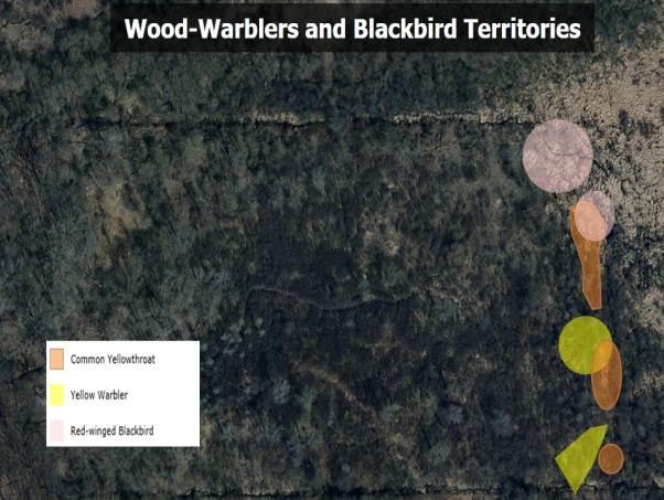
7 construct a method to eradicate them from the plots. Briefly speaking, the ground squirrels will eventually be considered pests to the crops that are harvested at LUREC. ADDITIONA ASSIGNMENTS CONDUCTED: Moth/butterfly collection and identification The moth/butterfly collection for the summer was somewhat not as exciting as I thought since the specimens were difficult to collect, and most of my time was invested in other projects. However, some of the more notable butterflies and moths collected during the summer include: the White-lined sphinx moth, the Yellow underwing moth, the Red-spotted Purple butterfly, the Cabbage butterfly, the Blue azure butterfly, the Polyphemus moth, and the Luna moth. There are now more than 100 species of Lepidoptera recorded at LUREC. Piezometer Transect Cutting Transect cutting was the most difficult job of all, and it was impossible to complete due to work load and time restrictions. Generally one to two days a week was reserved for helping Erin, the restoration intern cut and herbicide buckthorn along the transects lines leading to the piezometers. However, most trails leading to the piezometers have now been cleared, and should facilitate easier access to the majority of piezometers. The trails needed yet to be cleared are those that lead to piezometer 15 and 12. Piezometer and Outflow readings Piezometer and outflow readings were recorded once every two weeks. The restoration intern (Erin) and I conducted the readings on all occasions. All data collected that required conversion was converted, and entered into the LUREC s Management Committee file (K drive). Finalization of the Migratory Bird/butterfly Landscape Project and Spot-Mapping I was assigned to complete the designing of a bird/butterfly landscape project that was initiated by the ornithology class this summer. The project is to be implemented at LUREC in an effort to improve the ecosystem, and in turn, increase biodiversity. The landscape project was particularly focused in establishing a linear forest in the vicinity of the ponds, and in the back of the LUREC main building. The main idea behind this project is to introduce native plant species to the linear forest, in order to provide a permanent resource-rich environment for birds and other organisms during the year. In that way, migratory and resident avian species will have adequate resources, and possibly remain on campus. The assumption is that biodiversity will increase with the introduction of native shrubs and trees. In addition, I was also assigned to work on finishing a spot-mapping project using data that was gathered by the ornithology class here at LUREC (See Maps 3-5). However, the spotmapping project was only conducted in the back of the LUREC property (fen), using piezometers 13, 14 and 15 as the transect lines. When conducting avian breeding censuses in small areas, the spot-mapping method is usually employed as a means to determine which 7
8 species are breeding in the area, and then later used to estimate the populations of the different species in the locale. By using spot-mapping skills, scientists are able to establish territories for breeding individuals, and determine their preferred nesting sites. In accordance with baseline research conducted in the summer of 2012 here at LUREC, the data that was gathered by the ornithology class revealed that the birds that were breeding in the back of the property last year, also held similar territories this year. Therefore, the data suggests that birds may be very loyal to their breeding grounds, and return to utilize it for consecutive breeding sessions. In short, they are very site-specific. As a result, the restoration project presently in effect, will somewhat affect avian breeding grounds, if their nesting sites are removed. Bird Counts Conducting bird counts was not one of my job duties here at LUREC. However, as a lover of birds, I took this internship as an opportunity to improve my birding skills. Inquisitively, I conducted bird counts twice a month, to determine which bird species were present on campus at any given month during the summer/breeding season. During my bird counts, additional information such as weather, location, traveling distance, and time (start and end) were recorded. All data was entered into the citizen-scientists database ebird, and LUREC s naturalist log. Therefore, LUREC has a record of bird species seen or heard during the summer. In addition, the data is now available to researchers around to the world, who are interested in studying the differences in bird distributions at a global scale. LUREC Trails GPS LUREC trails were GPS ed and entered into Loyola s GIS software during this internship. The data was at the request of Loyola s GIS specialist David Treering. Accurate and precise representations of LUREC trails are now available to David through ArcGIS online (see Map2). 8

9 Appendix: Map1 9

10 Map 2 10

11 Map 3 Map 4 11

12 Map 5 Common Name Number Observed Number Dead Percentage (%) Black Cherry American Elm Bur Oak Yellow-bud Hickory White Ash Black Walnut Cottonwood Jack Pine Silver Maple Apple White Oak Table 1: PERCENTAGE OF TREES FOUND DEAD BY SPECIES 12
13 Species Summary Nest Sites All Sites Year 2013 Species Total # of nest attempts First egg date Total # of eggs Total # of nestlings Total # of fledglings Nest attempts with at least one fledgling Nesting success rate Blue Jay 1 5/12/ % Tree 1 6/12/ % Swallow Blackcapped Chickadee 1 6/3/ % House Wren Eastern Bluebird American Robin Gray Catbird Brown Thrasher Redwinged Blackbird 2 5/19/ % 2 5/25/ % 1 5/9/ % 1 5/28/ % 1 6/3/ % 2 6/18/ % Table 2: SPECIES SUMMARY FOR NESTS MONITORED AT LUREC 13

14 Photo 1 14


15 Photos 2 and 3 15


16 Photo 4 Photo 5 ***** I was unable to retrieve additional GIS maps of the trees that were GPS ed and the bird nest locations on campus from ArcGIS explorer online in time for this report, 16
~ BIRD SURVEY'S ON Mr. MANs~.-LELD
 ~ BIRD SURVEY'S ON Mr. MANs~.-LELD Introduction: In 993, breeding bird censuses were conducted for a third consecutive year on two permanent study sites on Mt. Mansfield, as part of a long-term Vermont
Washington State Park Bird Census 2017
 Washington State Park Bird Census 2017 A report to the Missouri Department of Natural Resources Washington State Park Bird Census Summary The Missouri River Bird Observatory conducted a basic bird census
FOREST BIRD SURVEYS ON MT. MANSFIELD AND UNDERBILL
 FOREST BIRD SURVEYS ON MT. MANSFIELD AND UNDERBILL STATE PARK Introduction: In 99, breeding bird censuses were conducted for a second year on two permanent study sites on Mt. Mansfield, as part of a long-term
Memo. Kevin Maddoux, Felsburg Holt & Ullevig. Jane Hann, Colorado Department of Transportation Kurt Kellogg, Felsburg Holt & Ullevig
 Memo To: cc: From: Kevin Maddoux, Felsburg Holt & Ullevig Jane Hann, Colorado Department of Transportation Kurt Kellogg, Felsburg Holt & Ullevig Keith Hidalgo, Felsburg Holt & Ullevig Date: July 9, 2007
COVER PAGE. Home address 5875 Brasstown Creek Road, Young Harris GA 30582
 COVER PAGE Name Dr. Olga Milenkaya (Olya) Title Assistant Professor of Biology Institution Young Harris College Division Math & Sciences Work address 1 College Street, Young Harris GA 30582 Home address
Come one! Come All! Join the Fun! It is the season for The National Audubon Society 116th Annual Christmas Count.
 Come one! Come All! Join the Fun! It is the season for The National Audubon Society 116th Annual Christmas Count. "The Christmas Bird Count, started by Frank Chapman along with 26 other conservationists,
Birdify Your Yard: Habitat Landscaping for Birds. Melissa Pitkin Klamath Bird Observatory
 Birdify Your Yard: Habitat Landscaping for Birds Melissa Pitkin Klamath Bird Observatory KBO Mission KBO uses science to promote conservation in the Klamath- Siskiyou region and beyond, working in partnership
Varying levels of bird activity within a forest understory dominated by the invasive glossy buckthorn (Rhamnus frangula)
") 1 Varying levels of bird activity within a forest understory dominated by the invasive glossy buckthorn (Rhamnus frangula) Tamara M. Baker Biology Department, College of Letters and Sciences, University
1 Varying levels of bird activity within a forest understory dominated by the invasive glossy buckthorn (Rhamnus frangula) Tamara M. Baker Biology Department, College of Letters and Sciences, University
Landscaping for Wildlife TOM PATRICK, President, Windstar Wildlife Institute
 Landscaping for Wildlife TOM PATRICK, President, Windstar Wildlife Institute If nothing moves in your landscape but a lawnmower, it s time to think of designing a natural yard. Rochelle Whiteman Photo
Black Swamp Bird Observatory Navarre, Ottawa NWR Banding Station Spring 2016
 Black Swamp Bird Observatory Navarre, Ottawa NWR Banding Station Spring The 38 th spring season began daily 16 April at the primary passerine banding station of the Black Swamp Bird Observatory. Operations
PROJECT WILDBIRD Food and Feeder Preferences of Wild Birds in the United States and Canada
 PROJECT WILDBIRD Food and Feeder Preferences of Wild Birds in the United States and Canada Executive Summary Dr. David J. Horn, Principal Investigator Department of Biology, Millikin University A Research
PHOTOGRAPHY. Birding Hotspots of UConn and the Surrounding Area JAMES ADAMS. 9 Merrow Meadow Park Fenton River.7. 5 New Storrs Cemetery 4
 9 Merrow Meadow Park 10 5 New Storrs Cemetery 4 6 Fenton River.7 7 Common Fields. 8 8 Eagleville Preserve..9 1 Horse Barn Hill. 1 2 W Lot.2 3 Mirror Lake 3 4 Swan Lake..3 9 Birding Hotspots of UConn and
Birding at Cylburn. For easy birding start on the grounds near the Cylburn Mansion... Proceed around the side of the Mansion...
 Birding at Cylburn For easy birding start on the grounds near the Cylburn Mansion... and scan the trees around the circle drive for Yellow-bellied Sapsucker in spring and fall and other woodpeckers year
A Practical Challenge for Atlasers: Identifying Juvenile Birds
 A Practical Challenge for Atlasers: Identifying Juvenile Birds Ageing sequence for birds: After hatching, a young bird s first plumage is called natal down. Prejuvenal (or postnatal) molt Juvenile (or
Grassland Bird Survey Protocol Sauvie Island Wildlife Area
 Grassland Bird Survey Protocol Sauvie Island Wildlife Area Project Objective: Help determine if native grassland bird species are benefiting from restoration of grassland/pasture habitats at the Sauvie
A Summary of Initial Findings in Establishing a Baseline Understanding of Lowland Black Ash Forest Communities, Polk County, Wisconsin
 A Summary of Initial Findings in Establishing a Baseline Understanding of Lowland Black Ash Forest Communities, Polk County, Wisconsin Brian M. Collins, Unity High School Life Sciences, Balsam Lake, Wisconsin
Trinity River Bird and Vegetation Monitoring: 2015 Report Card
 Trinity River Bird and Vegetation Monitoring: 2015 Report Card Ian Ausprey 2016 KBO 2016 Frank Lospalluto 2016 Frank Lospalluto 2016 Background The Trinity River Restoration Program (TRRP) was formed in
J A N U A R Y. Bird Calendar
 J A N U A R Y Watch for winter flocks of cardinals at your feeders. Observe which males and which females are dominant. Chickadees will also arrive in flocks. What other tag-along species show up at the
Black Swamp Bird Observatory Navarre Banding Station Fall 2014 Passerine Migration Monitoring Latitude 413 Longitude 0830
 Fall Passerine Migration Monitoring The 24th fall season began daily 20 August at our primary passerine banding station. This site is a barrier beach ridge along the southwest shore of Lake Erie. Operations
GENERAL PROTOCOL CONTENTS
 GENERAL PROTOCOL CONTENTS GENERAL PROTOCOL...3.2.2 Summary of protocols...3.2.2 Survey recommendations and tips...3.2.3 Forest bird recordings...3.2.5 Cowbirds and nest predators...3.2.6 Nests...3.2.6
Snake River Float Project Summary of Observations 2013
 We thank Anya Tyson for stepping in to organize the Nature Mapping volunteers and to compile the data for 2013. She kept the project afloat for the year. Below is Anya s report. Snake River Float Project
NEST BOX TRAIL HISTORY
 NEST BOX TRAIL HISTORY 1985-2016 by KEITH EVANS and JACK RENSEL INTRODUCTION In August of 1984, members of the Wasatch Audubon Society (Ogden, Utah) held a workshop to construct bluebird nesting boxes.
Evaluating Point Count Efficiency Relative to Territory Mapping in Cropland Birds 1
 1 André Cyr, Denis Lepage and Kathryn Freemark 2 Abstract: Species richness, composition, and abundance of farmland birds were compared between point counts (50-m, 100-m, and 150-m radius half circles)
Expansion Work Has Begun The perimeter dike for Cell 7 is now visible
 Summer/Fall 2017 In This Issue Poplar Island Expansion Wetland Cell 5AB Development Wildlife Update Birding tours on Poplar Island Expansion Work Has Begun The perimeter dike for Cell 7 is now visible
FOREST HABITAT 2015 ANNUAL REPORT
 SETTLEMENT AGREEMENT ARTICLE 0 FOREST HABITAT 01 ANNUAL REPORT REPORTING PERIOD JANUARY 1 DECEMBER 31, 01 BAKER RIVER HYDROELECTRIC PROJECT FERC No. 10 September 01 PUGET SOUND ENERGY Baker River Hydroelectric
Wildlife observations at the Olentangy River Wetland Research Park in 1998
 Wildlife 155 Wildlife observations at the Olentangy River Wetland Research Park in 1998 Sarah K. Harter School of Natural Resources The Ohio State University Introduction The abundance and diversity of
Earth Sanctuary. Breeding Bird Survey May 5-July 19, Compiled by Yvonne Palka and Frances Wood
 1 Earth Sanctuary Breeding Bird Survey May 5-July 19, 2003 Compiled by Yvonne Palka and Frances Wood Birds Identified as Breeding (using criteria established by the Audubon Society) Canada Goose Wood Duck
How to Observe. Access the species profiles using The Plants and Animals link in the Nature s Notebook navigation menu.
 How to Observe Nature s Notebook Plant and Animal Observations 3. START OBSERVING! a) Get Organized to Go Outside Now that you have set up your site outside and created your account online, you are ready
The effects of nest box location on Tree Swallow ( Tachycineta bicolor ) productivity and nest. success at Beaverhill Bird Observatory, Alberta
 productivity and nest. success at Beaverhill Bird Observatory, Alberta") The effects of nest box location on Tree Swallow ( Tachycineta bicolor ) productivity and nest success at Beaverhill Bird Observatory, Alberta Interns: Brandi Charette & Serena MacKay Mentor: Meghan Jacklin
The effects of nest box location on Tree Swallow ( Tachycineta bicolor ) productivity and nest success at Beaverhill Bird Observatory, Alberta Interns: Brandi Charette & Serena MacKay Mentor: Meghan Jacklin
A Rooftop Bird Survey of Facebook's Living Roof Eighteen-Month Report
 Santa Clara Valley Audubon Society A Rooftop Bird Survey of Facebook's Living Roof Eighteen-Month Report Team: Mackenzie Mossing, Shani Kleinhaus, Ralph Schardt Santa Clara Valley Audubon Society Introduction
. Summary of nest box monitoring at Elkhorn Slough National Estuarine Research Reserve
 . Summary of nest box monitoring 1998-2008 at Elkhorn Slough National Estuarine Research Reserve Overview and objectives Each spring and summer, a team of volunteers monitors about 150 nest boxes in the
PART FIVE: Grassland and Field Habitat Management
 PART FIVE: Grassland and Field Habitat Management PAGE 64 15. GRASSLAND HABITAT MANAGEMENT Some of Vermont s most imperiled birds rely on the fields that many Vermonters manage as part of homes and farms.
T.S Roberts Bird Sanctuary Improvements Project
 T.S Roberts Bird Sanctuary Improvements Project Dr. David Zumeta Ornithology and Forest Habitat Expert Jason Aune Landscape Architect, AFLA Tyler Pederson Project Manager Michael Schroeder Assistant Superintendent
Monitoring Avian Productivity and Survivorship on Oak Openings Preserve PROGRESS REPORT-2015 BSBO-16-3
 Monitoring Avian Productivity and Survivorship on Oak Openings Preserve Mark C. Shieldcastle, Research Director Black Swamp Bird Observatory 13551 West State Route 2 Oak Harbor, Ohio 43449 markshieldcastle@bsbo.org
Featured Sighting. VC Nature, Issue 1, March 2017
 VC Nature, Issue 1, March 2017 Featured Sighting Monday 2/20/2017, 4:45 PM- I was checking the beaver dam area when I saw a large bird sitting in the tree. Upon closer inspection, I realized it was a great
Effects of Herbaceous Field Borders on Farmland Birds in the Mississippi Alluvial Valley
 Technical Note July 26 Effects of Herbaceous Field Borders on Farmland Birds in the Mississippi Alluvial Valley Issued July 26 Information for this report was modified from the M.S. research of Ross R.
Date: April, 20, 2013 Location: Lake Conestee Nature Park, 601 Fork Shoals Rd, Greenville, S.C.
 Trip Report Date: April, 20, 2013 Location: Lake Conestee Nature Park, 601 Fork Shoals Rd, Greenville, S.C. Leader: Jeff Click Species List Compiled by: Brad Dalton Total Species: 83 species Resources:
NATIONAL PHENOLOGY NETWORK DATA INSTRUCTIONS
 NATIONAL PHENOLOGY NETWORK DATA INSTRUCTIONS To create an account or view data on the Florida Google Earth map on the USA-NPN site TO CREATE AN NPN ACCOUNT AND ENTER BLUEBIRD DATA 1. Go to NPN home page
WILDLIFE MONITORING FOR THE COLLABORATIVE FOREST RESTORATION PROGRAM Protocols for Monitoring Birds, Turkey, Deer and Elk
 WILDLIFE MONITORING FOR THE COLLABORATIVE FOREST RESTORATION PROGRAM Protocols for Monitoring Birds, Turkey, Deer and Elk David Parsons Melissa Savage January 2008 New Mexico Forest Restoration Series
Rook Title Rook 1996
 Rook 1996 Title Rook 1996 Description and Summary of Results The Rook Corvus frugilegus is an abundant and widespread resident bird in the UK. Largely because of its preference for feeding on agricultural
2006 OKLAHOMA BLUEBIRD NEST BOX RESULTS
 2006 OKLAHOMA BLUEBIRD NEST BOX RESULTS INTRODUCTION The Oklahoma Nestbox Trails Project was initiated in 1985 to enhance habitat for cavity-nesting birds in Oklahoma and reverse the population decline
Monitoring Avian Productivity and Survivorship on Oak Openings Preserve PROGRESS REPORT-2017 BSBO-18-3
 Monitoring Avian Productivity and Survivorship on Oak Openings Preserve Mark C. Shieldcastle, Research Director Black Swamp Bird Observatory 13551 West State Route 2 Oak Harbor, Ohio 43449 markshieldcastle@bsbo.org
I know that during the winter you migrate. But where do you come from in the spring?
 Bird Migrations I know that during the winter you migrate. But where do you come from in the spring? Winter Summer -this is an example of Bird Migration, which for most migratory birds involves flying
CORE *REQUIRED OF ALL COMMUNITIES* CIIY TOWN COUNIY YES YES YES YES YES
 CORE *REQUIRED OF ALL COMMUNITIES* ACTIVIIY COUNIY CIIY SEMI 1. Host a Community Wildlife Project Meeting 2. Add at least 4 books or videos dealing with wildlife or wildlife conservation to a school or
Instructor Guide: Birds in Human Landscapes
 Instructor Guide: Birds in Human Landscapes Authors: Yula Kapetanakos, Benjamin Zuckerberg Level: University undergraduate Adaptable for online- only or distance learning Purpose To investigate the interplay
Raptor Nest Field Survey Technical Memorandum for the North Meadows Extension to US 85 and Interstate 25
 for the North Meadows Extension to US 85 and Interstate 25 December 2007 Prepared for: Town of Castle Rock Douglas County Colorado Department of Transportation Federal Highway Administration Prepared by:
Birding at a Slower Pace - An Holistic Approach to Observing Birds: Why atlasing will improve your field skills AND your birding experience
 Birding at a Slower Pace - An Holistic Approach to Observing Birds: Why atlasing will improve your field skills AND your birding experience Bill Mueller, Director, Western Great Lakes Bird and Bat Observatory
Map. Bluebirds and Nest Boxes. Eastern Bluebird. Nest Boxes. W.K. Kellogg Bird Sanctuary Entrance
 Map Bookstore 1 Bluebirds and Nest Boxes Eastern Bluebird Auditorium Pollinator Garden Identification: Males are bright blue with a red-orange throat and white underparts. Females are duller. Juveniles
Egg Dates for Species that Breed in the SAAS Chapter Area
 Egg Dates for Species that Breed in the SAAS Chapter Area Egg Dates Unfledged Juveniles Fledglings Species First Last First Last First Last Great Horned Owl 28-Jan 8-May 8-Mar 12-Jun 9-Apr 9-Jun Horned
BRAS Bluebird Newsletter July 2017
 BRAS Bluebird Newsletter July 2017 Happy July! I hope you all had a relaxing and safe holiday and are enjoying summer! The bluebird trails are slowing down now that most of the tree swallows have fledged.
Go Au Naturale. Patrick Goggin / Carolyn Scholl Vilas County Land & Water Conservation Department
 Go Au Naturale Patrick Goggin / Carolyn Scholl Vilas County Land & Water Conservation Department Talk Outline Shoreland buffer zone overview Structural & plant components of wildlife habitat Checklist
2016 AND 2017 BLUEBIRD NESTBOX SURVEY RESULTS
 2016 AND 2017 BLUEBIRD NESTBOX SURVEY RESULTS Since the numbers of nestbox survey reports are so limited, two years of data are combined for this report. As always, the Oklahoma Wildlife Diversity Program
Oak Woodlands and Chaparral
 Oak Woodlands and Chaparral Aligning chaparral-associated bird needs with oak woodland restoration and fuel reduction in southwest Oregon and northern California Why conservation is needed Oak woodland
Bird Field Guides. Summary: Students will explore field guides by identifying local bird species and their characteristics.
 Oregon State Standards Grade 3: 01,04,05- L.S. Grade 5: 01-L.S. Common Core Standards RI.3.1 RI.3.2 RI.3.7 RI.3.8 RI.3.9 RI.4.1 RI.4.2 RI.5.1 RI.6.1 RI.6.2 RI.7.1 RI.7.2 RI.8.1 RI.8.2 RI.9-10.1 RI.9-10.2
2005 OKLAHOMA BLUEBIRD NEST BOX RESULTS
 25 OKLAHOMA BLUEBIRD NEST BOX RESULTS The Oklahoma Nestbox Trails Project was initiated in 1985 to enhance habitat for cavity-nesting birds in Oklahoma and reverse the population decline noted for the
MAKE YOUR GARDEN A HOME FOR BIRDS, BUTTERFLIES, & OTHER CRITTERS. Quita Sheehan, Conservation Specialist, Vilas County Land & Water Conservation
 MAKE YOUR GARDEN A HOME FOR BIRDS, BUTTERFLIES, & OTHER CRITTERS Quita Sheehan, Conservation Specialist, Vilas County Land & Water Conservation TALK OUTLINE Structural & plant components of wildlife habitat
Recreational Trails and Bird Communities
 - 1 - Recreational Trails and Bird Communities INTRODUCTION One of the most insidious challenges facing scientific researchers is their tendency to find what they are looking for: it can be incredibly
Table 1b. Coverage and Capture Rates During 2018 Fall MM at IBS
 Table 1b. Coverage and Capture Rates During 218 Fall MM at IBS Date Net-hours New Bandings Captures Recaptures Escapes Mortalities Total Captures/1 Net-hours 28-Jul 72.3 7 1 8.11 29-Jul 72.8 4 2 6.8 3-Jul
APPENDIX 15.6 DORMOUSE SURVEY
 APPENDIX 15.6 DORMOUSE SURVEY Picket Piece - Dormouse Nut Search Report Wates Development Limited December 2009 12260671 Dormouse report QM Issue/revision Issue 1 Revision 1 Revision 2 Revision 3 Remarks
Dynamic Forest Management: Forestry for the Birds
 Dynamic Forest Management: Forestry for the Birds Mark Peck April 18, 2017 Sharon Petzinger, Senior Zoologist NJ Fish and Wildlife s Endangered and Nongame Species Program Dynamic Forests Steve Maslowski
Shrubland Bird Ecology & Management. What are shrublands?
 Shrubland Bird Ecology & Management Matt Tarr Associate Extension Professor Wildlife Specialist University of New Hampshire Cooperative Extension Shrublands are habitats: dominated by shrubs and young
Survey Protocol for the Yellow-billed Cuckoo Western Distinct Population Segment
 Survey Protocol for the Yellow-billed Cuckoo Western Distinct Population Segment Halterman, MD, MJ Johnson, JA Holmes, and SA Laymon. 2016. A Natural History Summary and Survey Protocol for the Western
Listed Birds along the Stony Brook Corridor Impacted by BMS Zoning Change
 Listed Birds along the Stony Brook Corridor Impacted by BMS Zoning Change Washington Crossing Audubon Society (WCAS) opposes the zoning change to allow high density housing on the Bristol-Meyers Squibb
Checklist of birds on Nebraska farms
 1 Checklist of birds on Nebraska farms This checklist is based largely on observations of birds made, with permission, on Nebraska farms since the mid-1990s, as part of research conducted through the University
WVWA 2018 Wissahickon Birdathon Checklist
 Team: Count: This checklist contains 178 species recorded in birdathons from 1997 through 2017. Enter the locations you birded in the space provided at the top of each column. For each species recorded
large group of moving shorebirds (or other organism).
.") Bird Beans Grade Level: upper elementary/ middle school Duration: 30-40 minutes Skills: critical thinking, comparison, collection and interpretation of data, vocabulary, discussion, and visualization Subjects:
Bird Beans Grade Level: upper elementary/ middle school Duration: 30-40 minutes Skills: critical thinking, comparison, collection and interpretation of data, vocabulary, discussion, and visualization Subjects:
ZELLWOOD BIRD COUNTS JUNE, 2016
 ZELLWOOD BIRD COUNTS JUNE, 2016 June is often one of the quiet months but it does have the habit of turning up the unexpected so read on. There were four Roseate Spoonbills on the 21 st with an adult staying
Lesser Sandhill Cranes, Annual Summary Homer, Alaska, Summer By Kachemak Crane Watch
 Lesser Sandhill Cranes, Annual Summary Homer, Alaska, Summer 2016 By Kachemak Crane Watch This year s Sandhill Crane season started winding down on September 7 when roughly half of Homer s cranes took
Note: Some squares have continued to be monitored each year since the 2013 survey.
 Woodcock 2013 Title Woodcock Survey 2013 Description and Summary of Results During much of the 20 th Century the Eurasian Woodcock Scolopax rusticola bred widely throughout Britain, with notable absences
MIGRATION MONITORING AT PRINCE EDWARD POINT FALL 2013
 MIGRATION MONITORING AT PRINCE EDWARD POINT FALL 2013 by Stéphane Menu, Ph.D. 502007 Grey Road #1 Georgian Bluffs Ontario, N0H 2T0 stefmenu@gmail.com prepared for PRINCE EDWARD POINT BIRD OBSERVATORY November
Migrate Means Move (K-3)
") Migrate Means Move (K-3) At a glance Students role play as migrating birds. Time requirement One session of 45 minutes Group size and grades Any group size Grades K-3 Materials Photos or illustrations
Migrate Means Move (K-3) At a glance Students role play as migrating birds. Time requirement One session of 45 minutes Group size and grades Any group size Grades K-3 Materials Photos or illustrations
Sugar Creek Audubon Nature Sanctuary
 Sugar Creek Audubon Nature Sanctuary Sugar Creek Audubon Nature Sanctuary S ugar Creek Audubon Nature Sanctuary is a 49-acre preserve five miles west of Grinnell just off U.S. Highway 6. It is owned and
Habitat Discoveries. Summary: Students will learn about specific habitat requirements for birds through discussion, hands-on exploration, and mapping
 Oregon State Standards K.3S.1 K.3S.2 4.2L.1 5.2L.1 5.3S.2 Summary: Students will learn about specific habitat requirements for birds through discussion, hands-on exploration, and mapping Time: 60 minutes
Silver Lake Glossy Buckthorn Field Report. September-October 2012
 Silver Lake Glossy Buckthorn Field Report September-October 2012 Submitted by George Spak and Sandra Bonanno Introduction/Background Silver Lake is a spring fed glacial pothole in western Oswego County.
HUNGRYLAND BIRD LIST
 HUNGRYLAND BIRD LIST Jones/Hungryland Wildlife and Environmental Area Symbols Used in This Checklist Type Seasons species confirmed on this site species probably occurs on this site, based on habitat,
2017 Annual Volunteer Report
 2017 Annual Volunteer Report Volunteer Statistics Summary 23,164 DNR 280,419 Hours Donated 135 FTE s (Full Time Equivalents based on a 40-hour work week or 2,080 hours/year.) Volunteer hours are equivalent
BirdWalk Newsletter
 BirdWalk Newsletter 5.6.2018 Walks conducted by Perry Nugent and Ray Swagerty Newsletter written by Jayne J. Matney Cover Photo by Guenter Weber Obtaining the Grace for Take-off and Landing Now that spring
Forest Bird Habitat Assessment Fairlee Town Forest
 Forest Bird Habitat Assessment Fairlee Town Forest Fairlee, VT Prepared by: Steve Hagenbuch 1/3/2014 View north from Bald Top 2 Forest Bird Habitat Assessment Prepared for the Town of Fairlee, VT - Fairlee
Baskett Slough National Wildlife Refuge BCS number: 47-4
 Baskett Slough National Wildlife Refuge BCS number: 47-4 Site description author(s) Daphne E. Swope, Research and Monitoring Team, Klamath Bird Observatory Primary contact for this site N/A Location (UTM)
Appendix C-2. Nesting Bird Survey
 Appendix C-2 April 27, 2014 Rincon Project Number: 14-00929 Glassell Park, LLC Attn: Nancy Johns 23622 Calabasas Road, Suite 220 Calabasas, California 91302 Via Email: wildflowerdevelopment@yahoo.com Subject:
Subject: Pre-clearing Nest Survey Report for German Auto Import Network Track Near Duncan, B.C.
 Ursus Environmental Wildlife & Environmental Resource Consulting 600 Castle Way, Parksville, B.C. V9P 2R1 Ph/Fax: 250-248-1918 E-mail: ursusnanaimo@shaw.ca Date: April 11 th, 2014. To: Sarah Bonar, B.Sc.,
Exploring ebird. Common Core Standards Math 6.SP.B.4 6.SP.B.5 6.SP.B.5a 6.SP.B.5b 7.SP.B.3 7.SP.A.2 8.SP.A.1
 Oregon State Standards Science 4.2L.1, 4.3S.2 5.2L.1, 5.3S.2 6.2L.2, 6.3S.1, 6.3S.3 7.2E.3, 7.3S.1, 7.3S.2, 7.3S.3, 7.4D.2 8.3S.1, 8.3S.2 H.2L.2, H.2E.4, H.3S.1, H.3S.3 Common Core Standards Math 6.SP.B.4
PHENOLOGY LESSON TEACHER GUIDE
 PHENOLOGY LESSON TEACHER GUIDE Age Group: Grades 6-12 Learning Objectives: To develop an understanding of the interconnectedness of the three trophic levels To make the connections between climate change
Project Barn Owl. Title Project Barn Owl
 Project Barn Owl Title Project Barn Owl 1995-1997 Description and Summary of Results Throughout the 18th and early 19th centuries the Barn Owl Tyto alba was regarded as being the most common owl over much
Forest Structure and Bird Assemblages in Old-Growth and Managed Hemlock Hardwood Forests of the Western Laurentian Great Lakes Region, USA
 Forest Structure and Bird Assemblages in Old-Growth and Managed Hemlock Hardwood Forests of the Western Laurentian Great Lakes Region, USA By Michael Mossman 1, Robert Howe 2, and Nick Anich 1 1 Bureau
Yearly Total Summary, Birds Banded, 1995 through 2012 Dan Brown's Hummer Ranch, Christoval, Texas Listed in Phylogenetic Order
 Yearly Total Summary, Birds Banded, 1995 through 2012 Dan Browns Hummer Ranch, Christoval, Texas Listed in Phylogenetic Order Wood Duck 1 1 2 Gadwall 2 2 Green Heron 1 1 Sharp-shinned Hawk 1 2 1 1 5 Cooper
The Search for the Rusty Patched Bumble Bee: Citizen Science Protocol
 The Search for the Rusty Patched Bumble Bee: Citizen Science Protocol I Introduction The Rusty Patched Bumble Bee (RPBB) is a federally endangered Bumble Bee species that is native to the Eastern United
Peregrine Falcon Falco peregrinus
 Plant Composition and Density Mosaic Distance to Water Prey Populations Cliff Properties Minimum Patch Size Recommended Patch Size Home Range Photo by Christy Klinger Habitat Use Profile Habitats Used
Golden Eagle (Aquila chrysaetos) Management Indicator Species Assessment Ochoco National Forest
 Management Indicator Species Assessment Ochoco National Forest") Golden Eagle (Aquila chrysaetos) Management Indicator Species Assessment Ochoco National Forest I. Introduction The golden eagle was chosen as a terrestrial management indicator species (MIS) on the Ochoco
Golden Eagle (Aquila chrysaetos) Management Indicator Species Assessment Ochoco National Forest I. Introduction The golden eagle was chosen as a terrestrial management indicator species (MIS) on the Ochoco
BP Citizen Science Amphibian Monitoring Program Egg Mass Survey Results
 BP Citizen Science Amphibian Monitoring Program Egg Mass Survey Results Spring 2015 Prepared For: BP Cherry Point 4519 Grandview Rd Blaine, WA 98230 Prepared by: Vikki Jackson, PWS, senior ecologist Northwest
BRAS Bluebird Newsletter May 2017
 BRAS Bluebird Newsletter May 2017 We are in full swing on the bluebird trails! Lots of nests, lots of eggs and some fledgling bluebirds are being reported this month. Bluebirds have even started second
Buckner Preserve Shrubland Habitat Management Recommendations
 Buckner Preserve Shrubland Habitat Management Recommendations Margaret Fowle & Mark LaBarr Audubon Vermont 255 Sherman Hollow Rd Huntington, VT 05462 October 2015 Background Information The following pages
Purpose of this Study. Field Sites
 Methods in the Field Surveys of lots in Fall and Spring of 23 and Spring of 24 Walk slowly length of transect (~1 minutes) Count all birds seen or heard,, and Singing Birds Or the effects of exotic versus
B IRD CONSERVATION FOREST BIRD SURVEY: BIRD POPULATIONS IN CONNECTICUT AND RHODE ISLAND
 B IRD CONSERVATION V OLUME 13, NUMBER 3 JULY 2011 INSIDE THIS ISSUE: Forest Birds Survey 1 Forest Birds, continued 2 BCR Launches Online Journal Field Trips 4 3 FOREST BIRD SURVEY: BIRD POPULATIONS IN
Heights area, Houston Texas. Citizen Science Project of the Houston Audubon Society Introduction
 June 11, 2016 Red-vented Bulbul Survey, Heights area, Houston Texas. Citizen Science Project of the Houston Audubon Society Fred Collins and Kendra Kocab, Bulbul Survey Detectors organizers. Introduction
Massachusetts Grassland Bird Conservation. Intro to the problem What s known Your ideas
 Massachusetts Grassland Bird Conservation Intro to the problem What s known Your ideas Eastern Meadowlark Bobolink Savannah Sparrow Grasshopper Sparrow Upland Sandpiper Vesper Sparrow Eastern Meadowlark
WOODLANDS CONSERVANCY BIRD BANDING REPORT DECEMBER
 Woodlands Conservancy Banding Report WOODLANDS CONSERVANCY BIRD BANDING REPORT DECEMBER 12-13, 2013 by Donald Norman The Woodlands Conservancy banding got underway on Thursday and Friday, December 12 and
A survey of Birds of Forest Park in Everett, Washington
 A survey of Birds of Park in Everett, Washington This report summarizes a survey of bird species found in Park of Everett, Washington. The author is an intermediate-level, amateur birder who lives near
A presentation to: Rideau Lakes Municipal Services Committee Meeting March 14, A proposal for better cormorant control in Ontario
 A presentation to: Rideau Lakes Municipal Services Committee Meeting March 14, 2016 A proposal for better cormorant control in Ontario Background 30 species of cormorants worldwide Double-crested cormorant
Evaluation of wildlife response to vegetation restoration on reclaimed mine lands in southwestern Virginia
 Evaluation of wildlife response to vegetation restoration on reclaimed mine lands in southwestern Virginia Amy Carrozzino, Dean F. Stauffer, and Carola Haas Fisheries and Wildlife Sciences Department,