AVIFAUNAL IMPACT ASSESSMENT
|
|
|
- Cori Meryl Hudson
- 5 years ago
- Views:
Transcription


1 AVIFAUNAL IMPACT ASSESSMENT PROPOSED DEVELOPMENT OF THE ESKOM AGULHAS 400/132KV 2X500 MVA TRANSMISSION SUBSTATION AND LOOP-IN LOOP-OUT LINES, SWELLENDAM LOCAL MUNICIPALITY, WESTERN CAPE PROVINCE OCTOBER 2016 Prepared by: Afzelia Environmental Consultants P.O. Box 37069, Overport, 4067 Tel: Prepared for: Nsovo Environmental Consulting Tel: Fax:
2 Declaration I, Craig Widdows, declare that - I act as the independent specialist in this application; I do not have and will not have any vested interest (either business, financial, personal or other) in the undertaking of the proposed activity, other than remuneration for work performed in terms of the Environmental Impact Assessment Regulations, 2014; I will perform the work relating to the application in an objective manner, even if this results in views and findings that are not favourable to the applicant; I declare that there are no circumstances that may compromise my objectivity in performing such work; I will comply with the National Environmental Act (NEMA), regulations and all other applicable legislation; I have not, and will not engage in, conflicting interests in the undertaking of the activity; I undertake to disclose to the applicant and the competent authority all material information in my possession that reasonably has or may have the potential of influencing - any decision to be taken with respect to the application by the competent authority; and the objectivity of any report, plan or document to be prepared by myself for submission to the competent authority; all the particulars furnished by me in this form are true and correct. Signature of the specialist: Date: 06 October 2016 Specialist: Craig Widdows for Afzelia Environmental Consultants Contact person: Dr. Craig Widdows Qualification: PHD Ecology (UKZN) Postal address: 76 Valley View Road, Morningside Postal code: 4001 Cell: Telephone: Fax: Craig@afzelia.co.za Professional affiliation(s) (if any) IAIAsa SACNASP Pri.Sci.Nat: Membership Number Pending Although exercises due care and diligence in rendering services and preparing documents, the Consultants do not accept any liability, and the Client by receiving this document, indemnifies the Consultants (directors, managers, agents and employees) against all actions, claims, demands, losses, liabilities, costs, damages and expenses arising from or in connection with services rendered directly or indirectly by the Consultants and by the use of the information contained in this document Vryheid Strengthening Project: Avifaunal Assessment Page ii
3 Executive Summary were appointed by Nsovo Environmental Consulting (Pty) Ltd to undertake an avifaunal impact assessment for the proposed construction of the Agulhas 400/132kV 2X500 MVA Transmission Substation and Loop-in Loop-out lines and associated 132 kv distribution power line. The study area is located 20km south west of the town of Swellendam within the Swellendam Local Municipality, Western Cape. The proposed project will form part of the Vryheid Network Strengthening project in order to increase the power output within the area. The establishment of the Agulhas Transmission Substation (TS) will assist in resolving the transmission capacity constraints at the Bacchus Substation and will play an important role in addressing the energy transmission issues within the Western Cape Municipality. The primary aim of this assessment is to determine and assess the avifaunal communities associated with the study area and the sensitivity of the site from an avifaunal perspective. This will in turn provide valuable insight pertaining to the impacts of the substation on avian ecology within the study site. A total of 216 bird species are predicted to occur with the 3420AB quarter degree grid square within which the proposed substation and associated power line will traverse (South African Bird Atlas Project 2), two of which are considered Endangered, three listed as Vulnerable and two are considered Near Threatened (Barnes 2014). Avian species likely to be impacted by the proposed substation and associated 132Kv loop-in loop-out lines include local populations of endemic passerine species (Agulhas Long-billed Lark), locally resident or transient raptors (Martial Eagle and Black Harrier) and large terrestrial birds (Denham s Bustard, Blue Crane and Secretarybird). During the site visit 71 bird species were recorded within the greater study area including the Near Threatened Blue Crane (Anthropoides paradiseus) and Karoo Korhaan (Eupodotis vigorsii), the Vulnerable Denham s Bustard (Neotis denhami), and the Endangered Black Harrier (Circus maurus). The avian composition was dominated by smaller passerine species including African Stonechat (Saxicola torquatus), Familiar Chat (Cercomela familiaris), Common Waxbill (Estrilda astrild), Cape Sparrow (Passer melanurus) and Southern Red Bishop s (Euplectes orix). The impacts associated with the proposed substation and 132kV power line project include: Destruction and alteration of avian habitats; Disturbance and displacement of bird species; and Collision and electrocution on associated overhead power lines. Collisions with the earth wire is the main impact associated with the project. In order to mitigate this impact, it is imperative that earth wires crossing important avian habitats (agricultural lands, rivers, drainage lines and avian flyways) are fitted with anti-collision marking devices to increase the visibility of the power line and reduce likelihood of collisions. These must be Eskom approved anti-collision devices that are durable as the area is prone to strong winds. Further to this, electrocution of birds on the power line infrastructure also poses a risk to avifaunal species. The construction of the proposed new Eskom Agulhas MVA transmission substation and associated power line at site alternative A and C are the most favourable sites from an avifaunal perspective. These sites will pose a limited threat to the birds occurring in the vicinity of the new infrastructure. This is largely due to the extensive impacts already evident at the sites (existing 400kV power line, transformed landscape and few suitable avian Vryheid Strengthening Project: Avifaunal Assessment Page iii
4 micro-habitats) coupled with the short length (4.9km and 4.4km respectively) of the associated loop-in loop-out power line and 132kV distribution power line. The power line poses a moderate collision risk once the recommended mitigation measures are implemented. Given the relative homogeneity of the habitat within the study area as well as existing levels of disturbance (existing power line infrastructure, roads, urban development, agricultural practices), the proposed project is unlikely to have a significant, long-term impact on the local avifauna. Vryheid Strengthening Project: Avifaunal Assessment Page iv
5 Table of Contents 1. INTRODUCTION BACKGROUND AND LOCALITY OF THE ASSESSMENT SCOPE OF WORK IINFORMATION SOURCES UTILISED ASSUMPTIONS AND LIMITATIONS METHODOLOGY ASSESSMENT OF THE STUDY AREA BASELINE BIOPHYSICAL CHARACTERISTICS AVIAN MICRO-HABITATS IMPORTANT BIRD AREAS (IBA) AVIFAUNA SPECIES COMPOSITION PREDICTED PRIORITY SPECIES SENSITIVITY ASSESSMENT COMPARISON OF SITE ALTERNATIVES IMPACTS ASSOCIATED WITH THE SUBSTATION PROJECT SIGNIFICANCE OF IDENTIFIED IMPACTS CONSTRUCTION PHASE IMPACTS OPERATIONAL PHASE IMPACTS CONCLUSION REFERENCES Vryheid Strengthening Project: Avifaunal Assessment Page v
6 List of Tables Table 1. Red Listed bird species recorded in the 3420AB quarter degree square within which the proposed substation and loop in loop out lines are located Table 2. Significance scoring used for each potential impact Table 3. Impact assessment for the proposed substation and loop-in loop-out lines List of Figures Figure 1. Locality of proposed substation and associated infrastructure... 4 Figure 2. Site description map of the proposed site alternatives... 5 Figure 3. Vegetation type for the proposed study area... 7 Figure 4. Important Bird Areas surrounding the study area Figure 5. Sensitivity map of the study area Figure 6. Technique and guideline for marking of the earth wire with bird flapper devices (Adapted from Vosloo et al. 2014) List of Photographs Photograph 1. Overview of vegetation types and habitat structure located within the proposed study area and surrounds Photograph 2. Agricultural land consisting of grazing land (A) and Canola plantations (B) that dominated the study area Photograph 3. Several farm dams and riparian habitats identified within the study area. These areas are regarded as a sensitive avifaunal habitat as it provides suitable habitat for an abundance of species Photograph 4. Secretarybird (Sagittarius serpentarius) (Images extracted from Hockey et al. 2011) Photograph 5. Cape Vulture (Gyps coprotheres) (A) and Martial Eagle (Polemaetus bellicosus) (B). (Images extracted from Hockey et al. 2011) Photograph 6. Black Harrier (Circus maurus) (Images extracted from Hockey et al. 2011) Photograph 7. Denham s Bustard (Neotis denhami) (A) and Blue Crane (Anthropoides paradiseus) (B). Images extracted from Hockey et al. 2011) Photograph 8. Static Helical bird flight diverter and a mobile bird flapper device Vryheid Strengthening Project: Avifaunal Assessment Page vi
7 1. INTRODUCTION 1.1 BACKGROUND AND LOCALITY OF THE ASSESSMENT was appointed by Nsovo Environmental Consulting (Pty) Ltd to undertake an avifaunal impact assessment for the proposed Eskom Agulhas 400/132kv 2x500 MVA Transmission Substation and loop-in loop-out lines. Eskom Holdings SOC Ltd is proposing the construction of the Agulhas 400/132kV Main Transmission Substation (MTS): the construction footprint of the development will be 600m x 600m. The project will include the construction of a 132kV distribution line that will connect to the existing and new substations. The proposed development will form part of the Vryheid Network Strengthening project in order to increase the power output within the area. The establishment of the Agulhas Transmission substation will assist in resolving the transmission capacity constraints at Bacchus substation and will play an important role in addressing the energy transmission issues within the Western Cape Province. The proposed project study area is located on the Leeuw Rivier 251 Portion 3 and Kluitjeskraal 256 Portions 2, 5 & RE within the Swellendam Local Municipality, Western Cape Province (Figure 1). The site is located approximately 20 km from Swellendam along the Nation Road (N2) and Regional Road (R319). There are four proposed site alternatives, Site A, C, F and G, all of which are situated within the quarter-degree square 3420AB (Figure 2). Overhead power line infrastructure is known to negatively impact various avian species through direct mortality (collisions or electrocutions) of birds and indirectly through the removal of natural habitats. Interactions between birds and substation infrastructure is predicted to be less significant and impacts are likely to be indirect in nature due to habitat loss and disturbance. 1.2 SCOPE OF WORK The primary aim of this avifaunal impact assessment report was to evaluate the study area and determine the area s avifaunal sensitivity. Sensitivity refers to an area s ability to provide suitable nesting and foraging habitat for both Red Listed species and non-red Listed species. This aim was achieved through the following objectives: Site visit to identify important avian habitats within the study area as well as avian micro-habitats and species that will potentially use these ecological niches. A description of the current avifauna within the study area and the identification of Red Data species potentially affected by the proposed substation and associated power lines. Integration of the site data collected from avian atlases and counts within the area to develop a comprehensive avifaunal database likely to be present within the development footprint. Recommendations on which sites are preferable for the construction of the substation and associated loopin loop-out lines. The most favourable site will have a limited impact on avifauna. Vryheid Strengthening Project: Avifaunal Assessment Page 1
8 Identify potential negative impacts on the avifaunal diversity and species composition within the study area and assess the significance of these impacts. To provide recommended mitigation measures for the potential impacts in order to reduce the significance of the impacts on avifauna. 1.3 IINFORMATION SOURCES UTILISED The avifaunal assessment made use of the following data sources: Bird distribution data of the Southern African Bird Atlas Project obtained from the Avian Demography Unit of the University of Cape Town, in order to ascertain species occurrence within the study area (Harrison et al. 1997). The conservation and endemic status of all bird species occurring within the quarter degree square determined with the use of The Eskom Red Data book of birds of South Africa, Lesotho and Swaziland (Taylor 2014) and BirdLife SA checklist of endemics and near-endemics. The Important Bird Areas (IBA) programme according to BirdLife South Africa was consulted. A classification of the vegetation types in the study area was obtained from Mucina & Rutherford (2006) and SANBI (2012). 1.4 ASSUMPTIONS AND LIMITATIONS It is difficult to apply pure scientific methods within a natural environment without limitations, and project specific assumptions need to be made. The following constraints may have affected this assessment: The 3420AB quarter degree grid square, within which the project is located, is reasonably well covered by the South African Bird Atlas Project (SABAP2), with data recorded on data cards. As a result, the species diversity and densities recorded by SABAP2 provide an accurate interpretation of the avifauna potentially occurring within the study area. Avian behaviour is relatively unpredictable and cannot be reduced to formulas that will hold true under all circumstances. However, power line impacts can be predicted with a fair amount of certainty due to the vast amount of data available in this regard. Although the predicted impacts are mostly concerned with Red Data species, the non-red Data species will also benefit from the implementation of the proposed mitigation measures as they share the same habitat and affected by the same potential impacts. 2. METHODOLOGY The methodology used to predict impacts of the proposed project are outlined below. Vryheid Strengthening Project: Avifaunal Assessment Page 2
9 The various data sets and scientific publications were collected and examined to determine the sensitive avian species impacted by this study. The data was examined to determine the richness and abundance of species which may be susceptible to impacts from the proposed project. The broader study area was visited during a four-day site visit of the proposed sites. All four sites were thoroughly traversed to obtain a first-hand perspective of the proposed project and birdlife, and to determine which avian micro-habitats are present within the study site. This involved traversing the broader study area, taking photographs, and walking certain accessible areas, to see as much as possible of the proposed substation sites and route options for the power line. A desk top examination of the site, using Google Earth imagery was done to compare the power line route options and substation site alternatives. This was confirmed during the site visit. Avian micro-habitats and sensitive habitats for avifaunal communities were identified and mapped. The impacts of the proposed project on the avifaunal populations were predicted by analysing data on wildlife impacts with power lines and associated substation infrastructure throughout southern Africa. Vryheid Strengthening Project: Avifaunal Assessment Page 3

10 Figure 1. Locality of proposed substation and associated infrastructure Vryheid Strengthening Project-Loop in Loop out: Avifaunal Assessment Page 4

11 Figure 2. Site description map of the proposed site alternatives Vryheid Strengthening Project-Loop in Loop out: Avifaunal Assessment Page 5
12 3. ASSESSMENT OF THE STUDY AREA 3.1 BASELINE BIOPHYSICAL CHARACTERISTICS The Swellendam area is characterised by a winter rainfall pattern with some rain occurring in summer. The mean annual precipitation is approximately 462mm per year. It receives the lowest rainfall in June (23mm) and the highest in August (48mm). The average daily maximum temperatures range from 17.1 C in July to 27.5 C in January. The region is the coldest in July with minimum temperatures of 5.0 C (Mucina and Rutherford 2006). First frosts are normally experienced after June and continue through to the beginning of September. According to the National Vegetation Map (Mucina & Rutherford 2006 and SANBI, 2012) four vegetation types occur within the study area (Figure 2). North Sonderend Sandstone Fynbos occupies the north-west corner and central portions of the site while the Eastern Ruens Shale Renosterveld vegetation unit comprising the majority of the site. This vegetation type is characterised by moderately tall grassy shrubland dominated by Renosterbos. This vegetation type is considered critically endangered with at least 80% transformed mostly by cultivation and croplands (Mucina and Rutherford, 2006). Small outcrops of Ruens Silcrete Renosterveld are located along the southern section of the larger study area and Cape Lowland Alluvial Vegetation traverses the eastern boundary and central section of the study area. Lowland Alluvial Vegetation was primarily confined with drainage lines and associated riparian zones. Within the site, these different vegetation types are structurally very similar and all consist of low shrubland species with varying degrees of graminoid, succulents, forbs and geophyte cover, depending on the aspect and landscape position. The vast majority of the site has been transformed by intensive agriculture with all four site alternatives falling within agricultural cropland (Figure 3). There is remnant intact riparian vegetation along the drainage systems providing suitable habitat for nesting, foraging and roosting. The Bacchus-Proteus 400 kv line traverses through the northern portion of the study area and a substation is located to the south. The main topographical unit within the proposed study area consists of moderately undulating hills and plains which are characteristic of the area. Major water courses in the study area include the Breede River located to the north of the proposed site alternatives (2km), and the smaller Kluitjieskraalrivier (0.8km) which drains southwards to the east of the proposed site alternatives. Vegetation structure is considered more significant in determining avian species abundance and distribution than vegetation species composition (Harrison et al. 1997). As a result, the vegetation description within this assessment does not focus on the identification of floral species, but rather on vegetation structural units such as woodlands, riverine habitats or pans and wetlands. Vryheid Strengthening Project-Loop in Loop out: Avifaunal Assessment Page 6

13 Figure 3. Vegetation type for the proposed study area Vryheid Strengthening Project-Loop in Loop out: Avifaunal Assessment Page 7


14 Vryheid Strengthening Project-Loop in Loop out: Avifaunal Assessment


15 Photograph 1. Overview of vegetation types and habitat structure located within the proposed study area and surrounds. Vryheid Strengthening Project-Loop in Loop out: Avifaunal Assessment
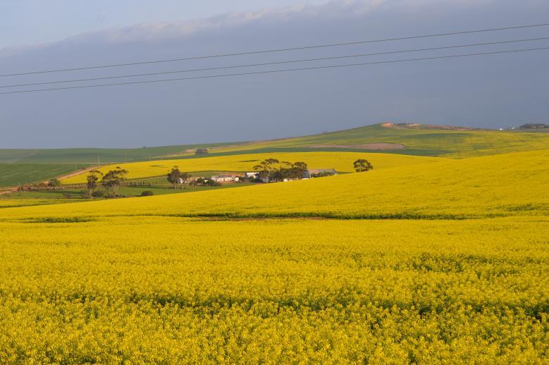
16 3.2 AVIAN MICRO-HABITATS Most of the abundance and distribution of avian species within the study area can be attributed to the vegetation types and bioregions. In determining the suitability of the study area for avian species, it is vital to examine the habitats available to these species. This will determine where the relevant species are most likely to occur within the study area. These micro-habitats do not necessarily correspond to vegetation types and are determined by a combination of vegetation type, topography, land use, food sources and other intrinsic factors. Investigation of the study area revealed several avian micro-habitats. In each case, some of the species likely to make use of the various micro-habitats have been described. Despite this, due to their mobile nature, avian species will utilise almost any area in a given landscape from time to time. Arable or cultivated landscape Agricultural land is the dominant land cover and the most common micro-habitat within the study area (Photograph 2). Wheat and Canola (Brassica napus L.) are the dominant crops cultivated within the study area. This micro-habitat is characterised by a monoculture, within limited existing shrub and tree species (apart from adjacent drainage lines). Avifaunal species associated with this open micro-habitat are dominated by grounddwelling species. Relevant avian species that will utilise this micro-habitat include Denham s Bustard (Neotis denhami), Blue Cranes (Anthropoides paradiseus) and various Heron species. In particular the White Stork (Ciconia ciconia) has a high affinity for arable land, with 80% of sightings in South Africa recorded within this habitat (Dean & Ryan 2005). Farmland or cultivated land provides foraging opportunities for many bird species for the following reasons: i. Through the process of land preparation many insects, seeds, bulbs and other food sources become readily accessible to bird species; ii. The agricultural plants that are cultivated are often consumed by birds, or attract insects which are in turn consumed by birds; and iii. The use of agricultural lands as foraging sites is likely to fluctuate throughout the year. It is predicted that greater concentrations of birds will increase during spring when the fields are ploughed, and in late summer / autumn when the crops are harvested and the birds are attracted to feed on the residual grains. Despite these benefits, active agricultural lands are not preferentially utilised by certain avian species due to the lack of vegetation cover and the regular disturbance experienced during the harvesting period. Areas where agricultural lands meet with natural shrublands has created a mosaic habitat merging the foraging advantages of the agricultural habitats and the protection of shrubland habitats. Vryheid Strengthening Project-Loop in Loop out: Avifaunal Assessment Page 10
 and Canola plantations (B) that dominated the study area The impacts associated with the substation and power line development within this")
. These dams often hold large quantities of predictably available water.")
17 A B Photograph 2. Agricultural land consisting of grazing land (A) and Canola plantations (B) that dominated the study area The impacts associated with the substation and power line development within this micro-habitat are displacement of avian species due to habitat loss and disturbance as well as collisions with the associated power line (Denham s Bustard and Blue Crane). Farm dams and drainage lines The eastern section of the study area contains a series of farm dams (Photograph 3). These dams often hold large quantities of predictably available water. These water sources are often used by large flocks of granivorous bird species such as Cape Sparrow (Passer melanurus), Cape Canary (Serinus canicollis), Brimstone Canary (Crithagra sulphurata) and Southern Red Bishop s (Euplectes orix). Drainage lines traverse the eastern and western boundaries of the study area (Photograph 3). Various species of water birds are mostly restricted to riverine habitat in Southern Africa. These drainage lines and associated riparian zones are important for Denham s Bustard as they provide foraging opportunities (invertebrates and small vertebrates). Furthermore, the riparian ecotone provides habitat for various species such as Kingfishers, Robin-Chats, Thrushes and Hammerkop (Scopus umbretta). Although the drainage lines within the area are negatively impacted due to the disturbance and encroachment from the croplands, they provide important corridors of natural vegetation, cover and nesting opportunities for many avian species within the largely agricultural landscape. They also represent an important flight path for many species. The main impact associated with this habitat include habitat destruction, disturbance and collisions with the power line (larger species with low maneuverability). Vryheid Strengthening Project-Loop in Loop out: Avifaunal Assessment Page 11


 and Martial Eagles (Polemaetus bellicosus)) from which to hunt and to nest.")

18 Photograph 3. Several farm dams and riparian habitats identified within the study area. These areas are regarded as a sensitive avifaunal habitat as it provides suitable habitat for an abundance of species Artificial micro-habitats Artificial habitats are provided by the existing overhead power lines that traverse through the study area. The pylons are used by various species including raptors ((Jackal Buzzard (Buteo rufofuscus), Pale-chanting Goshawk (Melierax canorus) and Martial Eagles (Polemaetus bellicosus)) from which to hunt and to nest. Smaller raptor species such as Rock Kestrels and Black-shouldered Kites will also utilised power lines for perching. Therefore, power line infrastructure may benefit these species due to the limited occurrence of large trees from which to perch and hunt. Vryheid Strengthening Project-Loop in Loop out: Avifaunal Assessment Page 12
19 3.3 IMPORTANT BIRD AREAS (IBA) The Important Bird Areas are identified as areas that are important for the long-term survival of threatened, restricted avian species. All substation site alternatives fall within the Overberg Wheat-belt (SA115) Important Bird Area. The extent of the IBA is ha and forms part of the Fynbos Biome. The landscape of the area consists of low lying hills and the natural Renoster vegetation in most areas has been replaced by cereal croplands and artificial pastures. This IBA supports 304 bird species and hosts 30% of South Africa s Blue Crane (Anthropoides paradiseus) population as well as a large portion of the global range of the Agulhas Long-Billed Lark (Certhilauda brevirostris). The IBA also hosts large numbers of Denham s Bustard (Neotis denhami), White Stork (Ciconia ciconia) and Black Storks (Ciconia nigra). IBA trigger species for this area include Cape Vulture (Gyps coprotheres), Blue Crane, Martial Eagle (Polemateus bellicosus), Black Harrier (Circus maurus), Denham s Bustard, Secretarybird (Sagittarius serpentarius) and Southern Black Korhaan (Afrotis afra). The Langeberg Mountains (SA 113) is located approximately 5km north of the study area and a total of 206 bird species have been recorded within this area. IBA trigger species include Denham's Bustard, Martial Eagle, Black Harrier, Hottentot Buttonquail, Knysna Woodpecker and Knysna Warbler and Verreauxs' Eagle. According to BirdLife South Africa, one-third of the 112 IBA s located within South Africa are under threat by alien invasive vegetation, habitat modification and agricultural expansion (Marnewick et al. 2015). It is important to include mitigation measures to ensure the development does not have a significant negative affect on protected avian species and source populations occurring within the IBA. As the proposed study falls within the Overberg Wheat-belt (SA115) Important Bird Area and in close proximity to the Langeberg Mountains IBA, it is important to implement the outlined mitigation measures to ensure the development does not have a long term negative impact on protected bird species. Vryheid Strengthening Project-Loop in Loop out: Avifaunal Assessment Page 13

20 Figure 4. Important Bird Areas surrounding the study area Vryheid Strengthening Project-Loop in Loop out: Avifaunal Assessment Page 14
21 4. AVIFAUNA SPECIES COMPOSITION A total of 216 species are predicted to occur within the study area and wider impact zone (SABAP2), with six species (3%) classified as Red Data species (Barnes 2014). Furthermore, five species are southern African endemics and eleven are near-endemics. Reporting rates are an indication of the relative density of a species on the ground in that it reflects the number of times that a species was recorded relative to the total number of cards that were completed for the pentad 1. During the site visit a total of 71 bird species were recorded within the study area (Appendix A). This figure was much lower than the species rich area to the east of the site within the Bontobok National Park (219 species recorded). The most commonly recorded species within the study sites were passerine species such as Waxbills, Sparrows and Canaries. Numerous species often associated with anthropogenically 2 modified landscapes were also recorded in close proximity to agricultural lands including Red-eyed Dove (Streptopelia semitorquata), Cape Sparrow (Passer melanurus), Pied Crow (Corvus albus) and Familiar Chat (Cercomela familiaris). The drainage lines micro-habitats were observed to have the highest abundance and species richness as opposed to the open agricultural landscape. Species identified within the drainage line habitat included Bokmakierie (Telophorus zeylonus), Cape Spurfowl (Pternistis capensis), Cape Teal (Anas capensis), and Malachite Sunbird (Nectarinia famosa). The agricultural land within the proposed site alternatives were fairly unproductive with a low avian species diversity and abundance. This habitat type was dominated by Common Fiscal (Lanius collaris), African Stonechat (Saxicola torquatus), Common Waxbill (Estrilda astrild), Cape Sparrow (Passer melanurus) and Southern Red Bishop (Euplectes orix). The Jackal Buzzard and Black Harrier were the only medium-large raptor species recorded during the site visit. Endemism is the ecological status of a species that is unique to a defined geographic location and does not occur anywhere else in the world. Endemic avian species in most cases have a limited and restricted range (Klerk et al. 2002). The restricted range of these species makes them susceptible to population decline due to anthropogenic impacts encroaching on their specific habitat requirements. Endemic species recorded during the site visit included Cape Bulbul (Pycnonotus capensis) and Agulhas Long-billed Lark (Certhilauda brevirostris) and near-endemic species included Jackal Buzzard (Buteo rufofuscus), Fiscal Flycatcher (Sigelus silens) and Black Harrier (Circus maurus). Several endemic species whose distributions occur within the study area were identified during the site visit. Most of these species are not threatened and occur in other localities within the subregion. The avifaunal species composition within the study area comprises of a variety of species that occur in numerous habitats and not exclusively within the study area. Despite this, various priority species were noted within the study area and the site from an avifaunal perspective is predicted to be of a moderate significance. 1 A 5-minute X 5-minute coordinate grid super-imposed over the continent for spatial reference. One QDGC comprises of 9 pentads. 2 A disturbance created as a result of human activities. Vryheid Strengthening Project-Loop in Loop out: Avifaunal Assessment Page 15
22 4.1 PREDICTED PRIORITY SPECIES Table 1 provides a guideline of the Red Data species that could potentially be encountered anywhere within the pentad where suitable habitat is available, and should therefore not be used as a measure of actual densities within the study area. Report rates are the likelihood of a particular species occurring along any of the alignments/ substation sites represented as a percentage. Furthermore, it is also important to note that these species were recorded within the entire quarter degree square and may not have actually been recorded on the proposed site for the study. Species that are in bold were recorded during the site visit. Vryheid Strengthening Project-Loop in Loop out: Avifaunal Assessment Page 16
23 Table 1. Red Listed bird species recorded in the 3420AB quarter degree square within which the proposed substation and loop in loop out lines are located NAME CONSERVATION STATUS (2014) HABITAT LIKELIHOOD OF OCCURRENCE HABITAT DESTRUCTION DISTURBANCE COLLISIONS WITH POWER LINE ELECTROCUTION SECRETARYBIRD Sagittarius serpentarius VU Open grassland with scattered shrubs Low X X CAPE VULTURE Gyps coprotheres EN Grassland/Arid Savannah Low X X KAROO KORHAAN Eupodotis vigorsii NT Open Plains/Karoo Shrubland Likely X X X MARTIAL EAGLE Polemaetus bellicosus VU Woodland/Savannah Low X X X BLACK HARRIER Circus maurus EN Fynbos shrubland and agricultural land likely X X BLUE CRANE Anthropoides paradiseus NT Croplands, pastures cultivated lands. Wetlands and Grasslands High X X DENHAM'S BUSTARD Neotis denhami VU Arable land/wetland Highly likely X X X *NT= Near Threatened; VU=Vulnerable; EN= Endangered Vryheid Strengthening Project-Loop in Loop out: Avifaunal Assessment Page 17
. As the majority of the site has an absence of trees, apart from a series of drainage lines, this may account for the limited sightings of this species.")
24 Secretarybird Secretarybirds roost and nest in trees (optimal heights range from 4-15 metres) and areas with these breeding requirements are important for local populations (Herholdt and Anderson 2006). As the majority of the site has an absence of trees, apart from a series of drainage lines, this may account for the limited sightings of this species. Secretarybirds are also very sensitive to disturbances such as habitat degradation due to overgrazing and anthropogenic activities and they generally avoid these areas. As the study area falls within a highly disturbed agricultural landscape this may account for the low reporting rate of this species within this landscape. This species was not recorded during the site visit. Photograph 4. Secretarybird (Sagittarius serpentarius) (Images extracted from Hockey et al. 2011). Cape Vulture and Martial Eagle There were no sightings of the Cape Vulture and Martial Eagle during the site visit. The SABAP2 reporting rate for both species within the pentad was very low and this was further supported by the lack of suitable habitats. Furthermore, the availability of nest sites and suitable habitat is often a limiting factor for both species. P. bellicosus build their nests in large trees (ranging from 6-20 metres high) and the lack of large trees within the study area may account for the limited sightings of Martial Eagles. Both species also suffer from the direct (trapping and shooting) and indirect (poisoning) persecution by farmers (BirdLife International Factsheet 2010). As the study area falls within agricultural land these factors may account for the limited sightings within this landscape. There has been a decline in the population size and range of the Cape Vulture over the past decade (Jenkins, 2010). The Cape Vulture is susceptible to mortalities associated with power line infrastructure (Collisions and electrocutions) and this has had a negative impact on the population dynamics. As power line infrastructure continue to expand into a variety of habitats within South Africa, it is likely to add further pressure to existing populations. Through the alteration of power line tower designs, electrocution risks have been reduced but mortalities resulting from collisions with power lines are still a cause for concern. Due to the limited length of the associated loop-in loop out lines, coupled with the study areas position in a largely cereal production dominated landscape, it is unlikely that regional populations of Cape Vulture and Martial Eagles will be impacted by the proposed project. Vryheid Strengthening Project-Loop in Loop out: Avifaunal Assessment Page 18


 (Images extracted from Hockey et al.")
25 A B Photograph 5. Cape Vulture (Gyps coprotheres) (A) and Martial Eagle (Polemaetus bellicosus) (B). (Images extracted from Hockey et al. 2011). Black Harrier The Black Harrier is a ground nesting species and is expected to move through the study area. This species favours habitats close to water and damp vegetation close to pans. The Black Harrier was only recorded on the eastern boundary of the study area and the flight path was in the direction of the National Park. This area has large sections of natural Renosterveld vegetation. Although this species forages within agricultural landscapes they require untransformed Renosterveld habitat for breeding (BirdLife SA). This may account for the confined sightings within the area. The Black Harrier is considered prone to disturbance and displacement during the construction of phase of the project. Photograph 6. Black Harrier (Circus maurus) (Images extracted from Hockey et al. 2011). Blue Crane and Denham s Bustard Blue Cranes and Denham s Bustard were recorded within the southern and eastern sections of the proposed study area. Both species are vulnerable to collisions with power lines (Allan 1996b). The existing 400kV power line is located within the northern section of the study area and may account for the limited sightings within its proximity. The core distribution of Blue Cranes in South Africa is located in croplands of the Western Cape and populations are increasing within the Swartland area (Young et al. 2003). The study area falls within the Overberg Wheat Belt and this Important Bird Area (IBA) contains 30% of South Africa s Blue Crane population. Vryheid Strengthening Project-Loop in Loop out: Avifaunal Assessment Page 19
, and low altitude")

26 This was confirmed during the site visit with groups of individuals observed within the agricultural landscape. Both species are susceptible to collisions with power lines due to their low mobility when in flight, inability to take evasive action (as stated previously with bustard species), and low altitude flight patterns when moving between feeding and breeding sites. A study conducted by Shaw et al. (2010) surveyed 199km of transmission and distribution power lines within the Overberg area. 54% of all avian carcasses found were Blue Crane and the study estimated 12% of the total Blue Crane population within the Overberg area could be killed annually by collisions with power lines (Shaw et al. 2010). This study also indicated that Denham s Bustard represented the second highest mortalities within the Overberg area, attributed to collisions with power line infrastructure. Due to the large populations of both species coupled with their susceptibility to collisions with power lines, it is imperative that appropriate mitigation measures are implemented to lessen the impact of the 132kV loop-in loopout line associated with the project. A B Photograph 7. Denham s Bustard (Neotis denhami) (A) and Blue Crane (Anthropoides paradiseus) (B). Images extracted from Hockey et al. 2011). Although this assessment focuses on Red Data bird species, other less threatened species will also potentially be affected by the proposed development. Mitigation measures proposed for Red Data species will therefore also serve to protect the more common species. 5. SENSITIVITY ASSESSMENT There is a correlation between the presence of Red Listed and endemic species stated above and the availability of various habitats within the study area. These important avian habitats influence the occurrence of species within a landscape providing nesting, foraging and reproductive benefits. The integration of these micro-habitats with the ability of priority species to make use of these habitats within the study site, is pivotal in predicting the sensitivity of the study area. Vryheid Strengthening Project-Loop in Loop out: Avifaunal Assessment Page 20
27 A sensitivity map was compiled for the study area by making use of the results of the avifaunal micro-habitat assessment in order to identify specific habitats that are more closely associated with avian impacts than others. A large portion of the study area has been assessed as being of Low and Medium sensitivity from an avifaunal perspective. The majority of the development footprint falls within the agricultural landscape unit and is considered to be of low ecological sensitivity as a result of the homogenous nature, which has severely transformed the ecological integrity of the area coupled with anthropogenic disturbance. This is not a unique habitat within the study area and populations of Blue Crane and Denham s Bustard that utilise this area will have alternative foraging sites. Development within this area could proceed with little risk of significant post-mitigation residual impact of protected avifaunal species, provided that stated mitigation measures are enforced. Areas of moderate sensitivity were located within the study area and are associated with the relatively intact natural Renosterveld vegetation. This natural habitat includes rocky outcrops that provide important foraging and roosting requirements for avian species. It is important that these areas are protected for degradation. High sensitivity avifaunal habitats are associated with the riparian habitat which traverse the study area. Although this contributes a small portion of the area, they are ecologically significant and represent an important habitat for avifaunal activity and attract many species. This is largely due to the intact nature of these drainage lines and riparian zones, allowing natural avian assemblages to persist within these areas. It will be important to maintain the connectivity of the drainage lines with the main system. Agricultural practices have encroached on this habitat but it is largely unaffected. It is important that this riparian habitat is protected from degradation. The protection of this habitat will provide an important ecological corridor and refugee for avifaunal species. Due to the size of the development coupled with the degraded nature of the site alternatives and limited sensitive areas within the study area, avifaunal populations should not be significantly affected provided that mitigation measures are implemented and the substation sites occur within the low sensitive areas as originally indicated. Vryheid Strengthening Project-Loop in Loop out: Avifaunal Assessment Page 21

28 Figure 5. Sensitivity map of the study area Vryheid Strengthening Project-Loop in Loop out: Avifaunal Assessment Page 22
29 6. COMPARISON OF SITE ALTERNATIVES Substation Site A: This is the northern substation site and is largely transformed and located next to the existing 400kV overhead power line and within close proximity to the National road (N2). The sum of impacts on avian species from the two power lines, within close proximity of one another, may be significantly lower than if these structures were separate in the landscape. The site is situated in old pasture land used for grazing and is in close proximity to human development. There are no sensitive micro-habitats within the site alternative and the site is likely to have low sensitivity for avifauna. Furthermore, the Loop-in loop-out line from the substation will be approximately 300m. The132kV distribution power line associated with site A is 4.6km. Therefore, the total length of new power line infrastructure will be 4.9km. Substation Site C: This is located to the west of substation Site A and is situated in old pasture land used for grazing. A farm dam micro-habitat is located within the vicinity of the site. This is the longest loop-in loop-out line and will be approximately 2039m from the substation. The 132 kv distribution power line associated with site C is 2.4km. Therefore, the total length of new power line infrastructure is 4.4km. This is the shortest line alternative. This short line alternative will pose a limited threat to the Blue Crane and Denham s Bustard population within the area, which have a high susceptibility to collision with overhead power lines in comparison to the other line alternatives. Substation Site F: This site alternative is located on elevated landform to the east of site A. This is located within an agricultural area (Wheat production) and the existing 400kV power line and National road (N2) are located within close proximity of this site. A drainage line micro-habitat is located to the south west of the site. The loop-in loop-out line will be approximately 260m. The 132 kv distribution power line associated with site F is 5.9km. Therefore, the total length of new power line infrastructure is 6.16km. The longer power line associated with this site alternative poses an increased risk of collision to Blue Cranes and Denham s Bustard. Substation Site G: This is the western most substation alternative. The site also falls within agricultural land (Canola cultivation) and is located adjacent to the N2. Blue Cranes were observed within close proximity to this site alternative. The loopin loop-out line will be approximately 760m. The 132 kv distribution power line associated with site G is 6.7km. Therefore, the total length of new power line infrastructure is 7.46km. This is the longest line alternative and the longer power line associated with this site alternative poses an increased risk of collision to Blue Cranes and Denham s Bustard. Due to the high levels of habitat transformation and disturbance levels substation site alternative A or C are preferable from an avifaunal perspective; they are unlikely to have a significant impact on avifaunal populations within the area. Both substation sites are also associated with the shortest distribution and loop-in loop-out power lines. Vryheid Strengthening Project-Loop in Loop out: Avifaunal Assessment Page 23
30 7. IMPACTS ASSOCIATED WITH THE SUBSTATION PROJECT The implications of the proposed substation development and associated power line to resident avifaunal assemblages include: An area of approximately 600m x 600m of agricultural land will be altered and considered artificial, and largely unsuitable to avian species. During the construction phase, disturbance levels will be significantly higher in the immediate vicinity than previously. This disturbance will consist of machinery and vehicle disturbance as well as other construction activities. During the operational phase, there will be some vehicle activity resulting in disturbance, particularly within the road access corridor. Since the substation will include the loop-in loop-out overhead power lines, this will potentially pose a collision risk to avifauna, particularly heavier birds with low manoeuvrability (Bustard and Crane species). The substation infrastructure provides perching and nesting substrate for various avifauna, particularly crows and smaller species such as sparrows and starlings. There is a possibility that species such as crows/owls could be electrocuted on substation infrastructure. 7.1 SIGNIFICANCE OF IDENTIFIED IMPACTS Significance scoring assesses and predicts the significance of environmental impacts through evaluation of the following factors; probability of the impact; duration of the impact; extent of the impact; and magnitude of the impact. The significance of environmental impacts is then assessed taking into account any proposed mitigations. The significance of the impact without mitigation is the prime determinant of the nature and degree of mitigation required. Each of the above impact factors have been used to assess each potential impact using ranking scales (Table 2). Unknown parameters are given the highest score (5) as significance scoring follows the Precautionary Principle. The Precautionary Principle is based on the following statement: When the information available to an evaluator is uncertain as to whether or not the impact of a proposed development on the environment will be adverse, the evaluator must accept as a matter of precaution, that the impact will be detrimental. It is a test to determine the acceptability of a proposed development. It enables the evaluator to determine whether enough information is available to ensure that a reliable decision can be made. Vryheid Strengthening Project-Loop in Loop out: Avifaunal Assessment Page 24
31 Table 2. Significance scoring used for each potential impact Probability 1 - very improbable 2 - improbable 3 - probable 4 - highly probable 5 - definite Extent 1 - limited to the site 2 - limited to the local area 3 - limited to the region 4 - national 5 - international Duration 1 - very short duration (0-1years) 2- short duration (2-5 years) 3 - medium term (5-15 years) 4 - long term (>15 years) 5 - permanent/unknown Magnitude 2 minor 4 low 6 moderate 8 high 10 very high Significance Points = (Magnitude + Duration + Extent) x Probability. The maximum value is 100 Significance Points. Potential Environmental Impacts are rated as high, moderate or low significance as per the following: <30 significance points = Low environmental significance significance points = Moderate environmental significance >60 significance points = High environmental significance Table 3. Impact assessment for the proposed substation and loop-in loop-out lines. Impacts associated with the construction phase of the activities Impact Habitat Destruction Disturbance to birds Electrocution on substation infrastructure Electrocution loop-in loopout power line Collisions with power line (Site A) Probability Duration Extent Magnitude Significance scoring Without With Without With Without With Without With without mitigation Construction Phase Operational Phase (high) 50 (moderate) 20 (low) 36 (moderate) 56 (moderate) Significance scoring with mitigation 48 (moderate) 28 (low) 8 (low) 20 (low) 30 (moderate) Vryheid Strengthening Project-Loop in Loop out: Avifaunal Assessment Page 25
32 Collisions with power line (Site C) (moderate) 30 (moderate) Collisions with power line (Site F) (moderate) 33 (moderate) Collisions with power line (Site G) (moderate) 33 (moderate) 7.2 CONSTRUCTION PHASE IMPACTS Habitat Destruction During the construction phase and maintenance of substations and power lines, some habitat destruction and alteration will occur due to the clearing of servitudes and vegetation at the substation site. These activities have an impact on foraging, breeding and roosting ecology of avian species within the area through modification of habitat. The continual clearing of servitudes will have the effect of altering bird community structure along the length of the power line (Kind and Byers, 2002). It is not envisaged that any Red Data species will be displaced by the habitat transformation that will take place as a result of the construction of the proposed substation. The impact on smaller, non-red Data species that are potentially breeding in the area will be local in extent, in that it will not have a significant effect on regional or national populations. The habitat is already largely transformed and fragmented by agricultural land. Furthermore, this is not a unique habitat within the landscape. The construction of the proposed transmission substation should therefore have a low displacement impact from an avifaunal perspective. Recommended Mitigation All construction and maintenance activities must be carried out according to the generally accepted environmental best practice and the temporal and spatial footprint of the development should be kept to a minimum. In particular, care must be taken in the vicinity of the drainage lines and existing roads must be used as much as possible for access during construction. The boundaries of the development footprint areas are to be clearly demarcated and it must be ensured that all activities remain within the demarcated footprint area. Special care must be taken in sensitive avifaunal micro-habitats such as drainage lines, pans and natural Renosterveld. Provide adequate briefing for site personnel. Any bird nests that are found during the construction period must be reported to the Environmental Control Officer (ECO). The above measures must be covered in a site specific EMPr and controlled by an ECO. Vryheid Strengthening Project-Loop in Loop out: Avifaunal Assessment Page 26
33 Disturbance and displacement The disturbance of avifauna during the construction and operation of the substation will occur. This is an indirect impact that will affect the movement and distribution of avian species surrounding the power line corridor, particularly during the construction of the proposed project. The avoidance of these areas by avian species will impact the breeding and foraging characteristics of affected bird species. Species sensitive to disturbance are ground-nesting species resident within the development footprint. Disturbance can also influence the community structure of avifauna within close proximity to the development as certain species will be displaced and forced to find alternative territories. Avian species with small territories are particularly susceptible. Disturbance can also influence the community structure of avifauna within close proximity to the development as certain species will be displaced and forced to find alternative territories. Disturbance could have a negative impact on the breeding activities of various species, particularly if this occurs during a sensitive period in the breeding cycle. Species of concern include Karoo Korhaan (Eupodotis vigorsii), Black Harrier (Circus maurus) and Blue Cranes (Anthropoides paradiseus). The Black Harrier often breed in damp vegetation in close proximity to wetlands or watercourses and Blue Cranes often breed on open ground near a water source (Hockey et al. 2006). These species will be sensitive to disturbance and habitat loss due to the construction of the proposed overhead power lines. Both the Black Harrier and Blue Cranes prefer habitats in close proximity to water sources (Hockey et al. 2006). The proposed site alternatives are located within an agricultural habitat close to national and regional roads as well as the Vryheid Substation. Therefore, species within this landscape often experience disturbance. As a result, disturbance of birds by the proposed substation is anticipated to be of low significance as birds will move away from the area temporarily. The relatively small scale of the development (in relation to the large agricultural landscape) is unlikely to have a significant impact on avifauna. However, species are particularly sensitive to disturbance during the breeding season and this must be borne in mind during both the construction and operational (maintenance) phases. Recommended Mitigation Strict control must be maintained over all activities during construction, in line with an approved Construction EMPr. During Construction, if any of the Red Data species identified in this report are observed to be roosting and/or breeding in the vicinity, the ECO must be notified. The construction camps must be as close to the site as possible. Contractors and working staff should stay within the development footprint and movement outside these areas including avian micro-habitats must be restricted. Driving must take place on existing roads and a speed limit of 30km/h must be implemented on all roads running through the study area during all phases. Vryheid Strengthening Project-Loop in Loop out: Avifaunal Assessment Page 27
34 7.3 OPERATIONAL PHASE IMPACTS Electrocution of birds on substation infrastructure Since there is live hardware in the substation yard, the potential exists for birds to bridge the gap between two phases or a phase and earth resulting in electrocution. However, very few electrocutions have been recorded on transmission substations. Species likely to be affected are crows and other species that are tolerant of disturbance. Small raptors such as Lanner Falcons are sometimes attracted into substation yards in pursuit of species nesting there such as sparrows and canaries. The impact assessment found the impact of electrocution on substation infrastructure to be of low significance once mitigation in the form of bird friendly structures and bird deterrent measures have been put in place. Species likely to be affected are crows and other non-threatened species with the majority of threatened species (Denham s Bustard and Blue Cranes) avoiding the substation yard as they are sensitive to disturbances. Recommended Mitigation A Bird Friendly monopole structure, with a bird perch (as per standard Eskom guidelines) should be used for the tower structures. All relevant perching surfaces should be fitted with bird guards as deterrents Electrocution of birds caused by the loop-in loop-out power line Electrocution 3 of birds on associated overhead power lines is an important cause of mortality for a variety of bird species particularly storks, cranes and raptors in South Africa (Van Rooyen & Ledger 1999). Electrocution occurs when a bird attempts to perch on the electrical structure and causes an electrical short circuit by physically bridging the air gap between live components and/or live and earthed components (van Rooyen 2004). The risk of electrocution is influenced by the voltage and the design of the tower structure coupled with the size of the bird species. Large species such as Vultures and Eagles are large enough to bridge the gap between two live phases. The impact of electrocution will be of high significance, and medium significance after the mitigation in the form of bird friendly structures. Recommended Mitigation A Bird Friendly monopole structure, with a bird perch (as per standard Eskom guidelines) should be used for the tower structures. All relevant perching surfaces should be fitted with bird guards and perch guards as deterrents (Hunting 2002). This must be conducted as per Eskom standard guidelines. Installation of artificial bird space perches and nesting platforms, at a safe distance from energised components (Goudie 2006; Prinsen et al. 2012). 3 Electrocution refers to the scenario where a bird is perched or attempts to perch on the electrical structure and causes an electrical short circuit by physically bridging the air gap between live components and/or live and earthed components (van Rooyen 2004). Vryheid Strengthening Project-Loop in Loop out: Avifaunal Assessment Page 28
35 Collisions with the power line Collisions are the biggest single threat posed by overhead power lines to birds in southern Africa (van Rooyen 2004). Larger bird species such as bustards, storks, flamingos, cranes and raptors are highly susceptible to power line collisions (Appendix 2). These species often collide with the earth wire as it is not highly visible. These species are mostly heavy-bodied species with limited manoeuvrability and are not sufficiently mobile to take the necessary evasive action to avoid colliding with power lines (Anderson 2001; Van Rooyen 2004, Jenkins and Smallie 2009). This impact is further exacerbated as they tend to fly between foraging bouts and roosting sites within the elevation ranges of both high and low voltage power lines. Many of the collision sensitive species are considered threatened in southern Africa. Areas that are regularly used by collision prone species for feeding, roosting or areas located along commonly used flight paths increases the risk of collisions. As a result, power line corridor selection is crucial in mitigating the negative impacts of this infrastructure of large avian species. The Red Data species that are vulnerable to power line collisions are generally long living, slow reproducing species. Various species require specific conditions for breeding, resulting in limited successful breeding attempts. Due to these breeding requirements these species have not evolved to cope with high adult mortality. Therefore, regularly high adult mortality over prolonged periods could have a will have an effect on species population dynamics. The potential collision of avian species with the power line earth wire is considered the most significant impact pertaining to avifauna within the project area. It is predicted that this impact will have a moderate negative impact prior to the implementation of mitigation measures. This is due to the presence of collision prone species including Denham s Bustard and Blue Crane and to a lesser extent Karoo Korhaan. Both species mentioned have been recorded within the top ten avian species in South Africa prone to collisions with overhead powerlines. The impact assessment found this risk to be of medium significance. However, this is directly related to the length of the power line. As would be expected the longer the power line, the higher the probability of larger birds colliding with the power line. This is compounded when the power line traverses important avifaunal micro-habitats and flight paths. The impact assessment found the risk of collision with the power line at site alternative A and C to be of moderate significance after mitigation as these sites require the shortest power line (4.9km and 4.4km respectively) thus reducing the risk of collision. Site alternatives F and G require an overhead power line length approximately 6.16km and 7.46km respectively. The increased length coupled with the presence of Red Data species increases the impact of the proposed development. Furthermore, these site alternatives are in close proximity with important avifaunal micro-habitats (particularly the large drainage line), the disturbance and degradation of which will compound the negative impact on avifauna within the area. Recommended Mitigation In order to mitigate for collision prone species, it is imperative that earth wires crossing important avian habitats are fitted with anti-collision marking devices to increase the visibility of the power line and reduce likelihood of collisions. These must be Eskom approved anti-collision devices that are durable as the area is prone to strong winds. Anti-collision devices must be installed as soon as the wires are strung. Vryheid Strengthening Project-Loop in Loop out: Avifaunal Assessment Page 29

36 EBM Flapper and the Tyco Flight Diverter are approved bird flight diverters which are currently used by Eskom (Transmission Bird Collision Guideline 2014; Distribution Technical Bulletin 2009). The devices must be installed 5m apart and alternate between a light and dark colour in order to increase the visibility of the earth wires. Furthermore 100% of the identified spans must be marked with devices as collision probability is equally possible along the entire span (Shaw 2013). According to Shaw (2013), marking of only 60% of the line may divert collision prone species to the unmarked portions of the line. Photograph 8. Static Helical bird flight diverter and a mobile bird flapper device Figure 6. Technique and guideline for marking of the earth wire with bird flapper devices (Adapted from Vosloo et al. 2014). Vryheid Strengthening Project-Loop in Loop out: Avifaunal Assessment Page 30
AVIFAUNAL IMPACT ASSESSMENT
 AVIFAUNAL IMPACT ASSESSMENT PROPOSED DEVELOPMENT OF THE ESKOM AGULHAS 400/132KV 2X500 MVA TRANSMISSION SUBSTATION AND LOOP-IN LOOP-OUT LINES, SWELLENDAM LOCAL MUNICIPALITY, WESTERN CAPE PROVINCE OCTOBER
We received the following information from SOLARRESERVE:
 Olievenhoutbosch Solar Photovoltaic Facility Avifaunal review 20 September 2017 1. Introduction This project consists of a Solar Photovoltaic facility in Olievenhoutbosch south-west of Centurion in Gauteng
Lighting up the African continent what does this mean for our birds?
 Lighting up the African continent what does this mean for our birds? JON SMALLIE¹, MEGAN DIAMOND 1 AND ANDREW JENKINS 2 ¹ Wildlife & Energy Interaction Group, Endangered Wildlife Trust, Private Bag X11,
Upgrade of the Tabor Substation and the deviation of the Tabor Louis Trichardt 132kV power line.
 BIRD IMPACT ASSESSMENT PROFESSIONAL OPINION Upgrade of the Tabor Substation and the deviation of the Tabor Louis Trichardt 132kV power line. Compiled by: Chris van Rooyen Consulting 30 Roosevelt Street
EF Retief Presenter. Co-Authors MD Anderson; D Harebottle; A Jenkins; R Simmons; HA Smit; C Van Rooyen; J Smallie
 EF Retief Presenter Co-Authors MD Anderson; D Harebottle; A Jenkins; R Simmons; HA Smit; C Van Rooyen; J Smallie The Wind Farm Industry in South Africa New programme in South Africa Only 8 wind turbines
Grahamstown Plan8 Wind Energy Facility
 APPENDIX 2: BIRD MONITORING PROGRESS REPORTS Appendix 2a: First Progress Report 19th May 2014 Grahamstown Plan8 Wind Energy Facility Pre-construction bird monitoring programme Progress report 1 submitted
BIRD IMPACT ASSESSMENT REPORT. 132kV Silimela MTS to Groblersdal Substation
 BIRD IMPACT ASSESSMENT REPORT 132kV Silimela MTS to Groblersdal Substation July 2015 Chris van Rooyen Chris has 19 years experience in the management of wildlife interactions with electricity infrastructure.
Best Practice Avifaunal Monitoring/Impact Assessment: The way forward in South Africa. Hanneline Smit
 Best Practice Avifaunal Monitoring/Impact Assessment: The way forward in South Africa Hanneline Smit conservation@birdlife.org.za Red Data species (125/844) = 15%! 1. Mortality = Collision with wind turbines
THE MERSEY GATEWAY PROJECT (MERSEY GATEWAY BRIDGE) AVIAN ECOLOGY SUMMARY PROOF OF EVIDENCE OF. Paul Oldfield
 AVIAN ECOLOGY SUMMARY PROOF OF EVIDENCE OF. Paul Oldfield") HBC/14/3S THE MERSEY GATEWAY PROJECT (MERSEY GATEWAY BRIDGE) AVIAN ECOLOGY SUMMARY PROOF OF EVIDENCE OF Paul Oldfield 1 1 DESCRIPTION OF THE BIRDLIFE IN THE UPPER MERSEY ESTUARY LOCAL WILDLIFE SITE 1.1
HBC/14/3S THE MERSEY GATEWAY PROJECT (MERSEY GATEWAY BRIDGE) AVIAN ECOLOGY SUMMARY PROOF OF EVIDENCE OF Paul Oldfield 1 1 DESCRIPTION OF THE BIRDLIFE IN THE UPPER MERSEY ESTUARY LOCAL WILDLIFE SITE 1.1
LINE AVIFAUNAL IMPACT ASSESSMENT. November WildSkies Ecological Services (Pty) Ltd
 Ltd") KRONOS-PERSEUS 765 kv OVERHEAD POWER LINE AVIFAUNAL IMPACT ASSESSMENT November 2013 Compiled by: Jessica Shaw & Jon Smallie WildSkies Ecological Services (Pty) Ltd jon@wildskies.co.za Submitted to: Judith
KRONOS-PERSEUS 765 kv OVERHEAD POWER LINE AVIFAUNAL IMPACT ASSESSMENT November 2013 Compiled by: Jessica Shaw & Jon Smallie WildSkies Ecological Services (Pty) Ltd jon@wildskies.co.za Submitted to: Judith
AVIFAUNAL IMPACT ASSESSMENT. October WildSkies Ecological Services (Pty) Ltd
 Ltd") ARIES-HELIOS 765 kv OVERHEAD POWER LINE AVIFAUNAL IMPACT ASSESSMENT October 2013 Compiled by: Jessica Shaw & Jon Smallie WildSkies Ecological Services (Pty) Ltd jon@wildskies.co.za Submitted to: Judith
ARIES-HELIOS 765 kv OVERHEAD POWER LINE AVIFAUNAL IMPACT ASSESSMENT October 2013 Compiled by: Jessica Shaw & Jon Smallie WildSkies Ecological Services (Pty) Ltd jon@wildskies.co.za Submitted to: Judith
WOLF WIND ENERGY FACILITY
 WOLF WIND ENERGY FACILITY EASTERN CAPE JUWI RENEWABLE ENERGIES (PTY) LTD AVIFAUNAL IMPACT ASSESSMENT (SCOPING PHASE) OCTOBER 2013 Prepared by: Prepared for: Jon Smallie Karen Versfeld WildSkies Ecological
Wintering Corn Buntings
 Wintering Corn Buntings Title Wintering Corn Bunting 1992/93 Description and Summary of Results The Corn Bunting Emberiza calandra is one of a number of farmland birds which showed a marked decline in
BIRD IMPACT ASSESSMENT STUDY
 BIRD IMPACT ASSESSMENT STUDY Proposed 132kV link line between relocated gas turbines and the national grid at the Ankerlig power station Western Cape Province Eskom Transmission Division Western Region
PART FIVE: Grassland and Field Habitat Management
 PART FIVE: Grassland and Field Habitat Management PAGE 64 15. GRASSLAND HABITAT MANAGEMENT Some of Vermont s most imperiled birds rely on the fields that many Vermonters manage as part of homes and farms.
CONTENTS 7. IMPACTS ON BIRDS Terms of reference Assumptions Sources of information 7 3
 CONTENTS 7. IMPACTS ON BIRDS 7-2 7.1.1 Terms of reference 7 2 7.1.2 Assumptions 7 2 7.1.3 Sources of information 7 3 7.2 DESCRIPTION OF ASPECTS THAT WOULD CAUSE IMPACTS ON BIRDS 7 4 7.2.1 Wind turbines
Peddie Wind Energy Facility Project AVIFAUNA IMPACT ASSESSMENT
 Peddie Wind Energy Facility Project AVIFAUNA IMPACT ASSESSMENT Prepared by: Prepared for: WildSkies Ecological Services Jon Smallie jonsmallie@gmail.com 082 444 8919 South Africa P.O. Box 934, Grahamstown
American Kestrel. Appendix A: Birds. Falco sparverius. New Hampshire Wildlife Action Plan Appendix A Birds-183
 American Kestrel Falco sparverius Federal Listing State Listing Global Rank State Rank Regional Status N/A SC S3 High Photo by Robert Kanter Justification (Reason for Concern in NH) The American Kestrel
Pongola Candover corridor routes for a 132 kv power line. Assessment of the implications for avifauna.
 Pongola Candover corridor routes for a 132 kv power line. Assessment of the implications for avifauna. 1. INTRODUCTION The proposed Pongola Candover power line and substation project will require environmental
20 April Ms Bongi Shinga Public Participation Team ACER (Africa) Environmental Consultants Via
 Environmental Consultants Via") 20 April 2015 Ms Bongi Shinga Public Participation Team ACER (Africa) Environmental Consultants Via email: publicparticipation@acerafrica.co.za Re: Environmental Impact Assessment: National Road 3, Keeversfontein
20 April 2015 Ms Bongi Shinga Public Participation Team ACER (Africa) Environmental Consultants Via email: publicparticipation@acerafrica.co.za Re: Environmental Impact Assessment: National Road 3, Keeversfontein
ADDENDUM TO BIRD IMPACT ASSESSMENT REPORT FOR THE PROPOSED WAAIHOEK WIND ENERGY FACILITY NEAR UTRECHT, KWAZULU-NATAL
 ADDENDUM TO BIRD IMPACT ASSESSMENT REPORT FOR THE PROPOSED WAAIHOEK WIND ENERGY FACILITY NEAR UTRECHT, KWAZULU-NATAL August 2015 Chris van Rooyen Albert Froneman Avifaunal Specialist Consultants 1. Introduction
Environmental Issues and Wind Energy Development in Egypt
 ecoda Environmental Consulting Dr. Thorsten Zegula Environmental Issues and Wind Energy Development in Egypt ecoda Environmental Consulting, Dr. Bergen & Fritz GbR Ruinenstr. 33, 44287 Dortmund, Germany
Ferruginous Hawk Buteo regalis
 Photo by Teri Slatauski Habitat Use Profile Habitats Used in Nevada Sagebrush Pinyon-Juniper (Salt Desert Scrub) Key Habitat Parameters Plant Composition Sagebrush spp., juniper spp., upland grasses and
The Contribution of the Important Bird Areas Programme to Conservation Planning in South Africa
 The Contribution of the Important Bird Areas Programme to Conservation Planning in South Africa Ernst Retief BirdLife South Africa Regional Conservation Manager Gauteng and North West Daniel Marnewick
SOUTH AFRICA BIRDING PHOTO TOUR WESTERN CAPE, WITH EXTENSION TO KRUGER NP
 SOUTH AFRICA BIRDING PHOTO TOUR WESTERN CAPE, WITH EXTENSION TO KRUGER NP 1 11 SEPTEMBER 2018 Cape Rockjumper (photo Andre Stapelberg) is one of our targets on this trip. 2 I T I N E R A R Y South Africa
Avifaunal pre-construction monitoring at the proposed Mainstream Loeriesfontein 2 and Khobab Wind Energy Facilities
 Avifaunal pre-construction monitoring at the proposed Mainstream Loeriesfontein 2 and Khobab Wind Energy Facilities Prepared by: Chris van Rooyen Albert Froneman Nico Laubscher Prepared for: Mainstream
Avifaunal Habitat Scan
 Avifaunal Habitat Scan of Erven 1 and 2 Lazer Park on a portion of the farm Wilgespruit 190-IQ (also known as African Leadership Academy) May 2016 Report author: Mr. Rihann F. Geyser Report verified/reviewed
Zeus Perseus -Vredefort Dome 765kv Extended Bird Impact Assessment Study
 Zeus Perseus -Vredefort Dome 765kv Extended Bird Impact Assessment Study Prepared by: Chris van Rooyen Endangered Wildlife Trust Private Bag X11 Parkview 2122 www.ewt.org.za Prepared for: PBA International
Guidance note: Distribution of breeding birds in relation to upland wind farms
 Guidance note: Distribution of breeding birds in relation to upland wind farms December 2009 Summary Impacts of wind farms on bird populations can occur through collisions, habitat loss, avoidance/barrier
Dassieridge Wind Energy Facility
 Dassieridge Wind Energy Facility Innowind (Pty) Ltd Final pre-construction bird monitoring report & avifaunal impact assessment December 2015 Compiled by: Jon Smallie WildSkies Ecological Services Jon@wildskies.co.za
Conservation of the Andaman Serpent Eagle Spilornis elgini in the Andaman Islands: Phase I. SACON Technical Report - 192
 Conservation of the Andaman Serpent Eagle Spilornis elgini in the Andaman Islands: Phase I SACON Technical Report - 192 Submitted to Raptor Research and Conservation Foundation, Godrej & Boyce Premises-1st
APPENDIX A Vernal Field Office Best Management Practices for Raptors and Associated Habitats
 APPENDIX A Vernal Field Office Best Management Practices for Raptors and Associated Habitats A-1 A-2 APPENDIX A VERNAL FIELD OFFICE BEST MANAGEMENT PRACTICES FOR RAPTORS AND ASSOCIATED HABITATS September
change. Presence and abundance of bird species, as described in the Avifaunal Scoping Report, would remain the same.
 change. Presence and abundance of bird species, as described in the Avifaunal Scoping Report, would remain the same. 5. Assessment of impacts All of the predicted impacts above, have been rated for significance,
Avian Project Guidance
 SPECIES MANAGEMENT Avian Project Guidance Stakeholder Informed Introduction Avian species, commonly known as birds, are found on every continent and play important roles in the world s ecosystems and cultures.
APPENDIX A ANNUAL COMPLIANCE REPORT CONDITION REQUIREMENTS CONDITION 4.0
 APPENDIX A ANNUAL COMPLIANCE REPORT CONDITION REQUIREMENTS CONDITION 4.0 Condition 4: Migratory Birds 4.1.1 The Proponent shall carry out all phases of the Designated Project in a manner that avoids harming
Scarlet Ibis Wind Energy Facility
 Scarlet Ibis Wind Energy Facility InnoWind (Pty) Ltd EDF EN Group Avifaunal impact assessment July 2017 REPORT REVIEW & TRACKING Document title Scarlet Ibis Wind Energy Facility- Avifaunal impact assessment
Ecological Impacts of Wind Farms: Global Studies. Are Wind Farms Hazardous to Birds and Bats? Stephen J. Ambrose
 Ecological Impacts of Wind Farms: Global Studies Are Wind Farms Hazardous to Birds and Bats? Stephen J. Ambrose Impact Phases Construction Phase: Habitat clearance Disturbances (noise, visual, dust etc.)
Kingston Field Naturalists
 Kingston Field Naturalists P.O. Box 831 Kingston, Ontario K7L 4X6 http://www.kingstonfieldnaturalists.org March 5, 2013 Mr. Sean Fairfield Manager, Environmental Planning Algonquin Power Co. 2845 Bristol
Loggerhead Shrike (Lanius ludovicianus)
") Loggerhead Shrike (Lanius ludovicianus) NMPIF level: Species Conservation Concern, Level 2 (SC2) NMPIF Assessment score: 14 NM stewardship responsibility: Moderate National PIF status: No special status
Loggerhead Shrike (Lanius ludovicianus) NMPIF level: Species Conservation Concern, Level 2 (SC2) NMPIF Assessment score: 14 NM stewardship responsibility: Moderate National PIF status: No special status
Listed Birds along the Stony Brook Corridor Impacted by BMS Zoning Change
 Listed Birds along the Stony Brook Corridor Impacted by BMS Zoning Change Washington Crossing Audubon Society (WCAS) opposes the zoning change to allow high density housing on the Bristol-Meyers Squibb
Birding the Overberg & Agulhas Plain
 World Seabird Conference Birding the Overberg & Agulhas Plain 31 st October to 2 nd November 2015 (3 days) Blue Crane by Adam Riley De Hoop Nature Reserve is approximately 34 000ha in size and lies on
Appendix 6-A. Review of Red Goshawk and Masked Owl
 Appendix 6-A Review of Red Goshawk and Masked Owl STEPHEN DEBUS BA, Dip Natural Resources (Wildlife), Dip Ed, MSc (Zoology), PhD (Zool.) ECOLOGIST PO Box 1015 Armidale NSW 2350 Fauna surveys Tel 02 6773
MAPHUTHA WITKOP 400KV POWER LINE AVIFAUNAL SPECIALIST STUDY
 MAPHUTHA WITKOP 400KV POWER LINE AVIFAUNAL SPECIALIST STUDY November 2017 Prepared by: Prepared for: Jon Smallie Rejoice Aphane WildSkies Ecological Services Nsovo Environmental Consulting 082 444 8919
INYANDA ROODEPLAAT WIND FARM, EASTERN CAPE: AVIFAUNAL IMPACT ASSESSMENT
 INYANDA ROODEPLAAT WIND FARM, EASTERN CAPE: AVIFAUNAL IMPACT ASSESSMENT REPORT TO SRK CONSULTING Dr Steve Percival Ecology Consulting Swallow Ridge Barn, Old Cassop, Durham DH6 4QB, UK. Email: steve.percival@ecologyconsult.co.uk
APPENDIX 15.6 DORMOUSE SURVEY
 APPENDIX 15.6 DORMOUSE SURVEY Picket Piece - Dormouse Nut Search Report Wates Development Limited December 2009 12260671 Dormouse report QM Issue/revision Issue 1 Revision 1 Revision 2 Revision 3 Remarks
INYANDA ROODEPLAAT WIND FARM, EASTERN CAPE, SOUTH AFRICA: BIRD SURVEYS UPDATE AUGUST 2015 JULY 2016
 INYANDA ROODEPLAAT WIND FARM, EASTERN CAPE, SOUTH AFRICA: BIRD SURVEYS UPDATE AUGUST 2015 JULY 2016 Report to Newcombe Wind Developments Black Harrier Steve Percival Steve Percival, Tracey Percival, Adri
Monitoring Avian Populations in Utah s Riparian Areas
 Monitoring Avian Populations in Utah s Riparian Areas Why monitor riparian birds? Look at results from 10 yrs of monitoring Population trends: linear & non-linear Compare techniques: relative abundance
SPATIAL CONSERVATION PLANNING FOR WIND FARM SITING IN LESOTHO
 SPATIAL CONSERVATION PLANNING FOR WIND FARM SITING IN LESOTHO Authors: J Hughes 1, A Jenkins 2, D Allan 3 and S Heather-Clark 4 Introduction Several wind farms have been proposed for the Mountain Kingdom
Golden Eagle (Aquila chrysaetos) Management Indicator Species Assessment Ochoco National Forest
 Management Indicator Species Assessment Ochoco National Forest") Golden Eagle (Aquila chrysaetos) Management Indicator Species Assessment Ochoco National Forest I. Introduction The golden eagle was chosen as a terrestrial management indicator species (MIS) on the Ochoco
Golden Eagle (Aquila chrysaetos) Management Indicator Species Assessment Ochoco National Forest I. Introduction The golden eagle was chosen as a terrestrial management indicator species (MIS) on the Ochoco
Special Habitats In Greene County
 Special Habitats In Greene County What does Greene County have in common with these animals.. That need special grassland habitat to survive? Or these That need special wetland habitat to survive? We have
Hendrina Ash Disposal Facility Expansion: Avifaunal Specialist Assessment of the Amendment to the Power Line Re-routing Alternatives
 : Avifaunal Specialist Assessment of the Amendment to the Power Line Re-routing Alternatives Addendum to the Original Avifaunal Report (EWT, 2011) On behalf of 5 th September 2014 Prepared By: Arcus Consultancy
Birds and Solar Energy Best Practice Guidelines
 BirdLife South Africa Birds and Solar Energy Best Practice Guidelines Best Practice Guidelines for assessing and monitoring the impact of solar power generating facilities on birds in southern Africa Compiled
EXPANSION OF THABAZIMBI, FERROGATE & NORTHAM RAILWAY LOOPS SPECIALIST AVIFAUNAL IMPACT ASSESSMENT JUNE 2017
 JUNE 2017 EXPANSION OF THABAZIMBI, FERROGATE & NORTHAM RAILWAY LOOPS SPECIALIST AVIFAUNAL IMPACT ASSESSMENT DRAFTED BY: MEGAN DIAMOND FEATHERS ENVIRONMENTAL SERVICES P.O. BOX 786962, SANDTON, 2146 MEGAN@FEATHERSENV.CO.ZA
Tiered Species Habitats (Terrestrial and Aquatic)
") Tiered Species Habitats (Terrestrial and Aquatic) Dataset Description Free-Bridge Area Map The Department of Game and Inland Fisheries (DGIF s) Tiered Species Habitat data shows the number of Tier 1, 2
Tiered Species Habitats (Terrestrial and Aquatic) Dataset Description Free-Bridge Area Map The Department of Game and Inland Fisheries (DGIF s) Tiered Species Habitat data shows the number of Tier 1, 2
Chapter-VIII SUMMARY AND CONCLUSION
 Chapter-VIII SUMMARY AND CONCLUSION Andaman and Nicobar Islands are very rich in bird diversity and hence have high importance in conservation planning. Both in species endemism and species diversity these
Winter Skylarks 1997/98
 Winter Skylarks 1997/98 Title Winter Skylarks 1997/98 Description and Summary of Results Numbers of breeding Skylarks Alauda arvensis declined by 58% in lowland British farmland between 1975 and 1994 but
Peregrine Falcon Falco peregrinus
 Plant Composition and Density Mosaic Distance to Water Prey Populations Cliff Properties Minimum Patch Size Recommended Patch Size Home Range Photo by Christy Klinger Habitat Use Profile Habitats Used
NATIONAL REPORT FOR THE AQUATIC WARBLER MOU AND ACTION PLAN REPUBLIC OF BULGARIA
 CMS/AW-1/Inf/3.2 NATIONAL REPORT FOR THE AQUATIC WARBLER MOU AND ACTION PLAN REPUBLIC OF BULGARIA This reporting format is designed to monitor the implementation of the Action Plan associated with the
Avifaunal Habitat Scan
 Avifaunal Habitat Scan of WESTDENE DAM RE-DEVELOPMENT ON A PORTION OF PORTION 33 OF THE FARM BRAAMFONTEIN 53 IR February 2015 Report author: Mr. R.F. Geyser Report verified/reviewed by: Dr. A.C. Kemp (Ph.D.,
University of Bristol - Explore Bristol Research
 Huntley, B., Collingham, Y. C., Singarayer, J. S., Valdes, P. J., Barnard, P., Midgley, G. F.,... Ohlemüller, R. (2016). Explaining patterns of avian diversity and endemicity: Climate and biomes of southern
Nzhelele Transmission Substation and 400kV powerline from Nzhelele substation to Tabor Substation.
 Nzhelele Transmission Substation and 400kV powerline from Nzhelele substation to Tabor Substation. DRAFT AVIFAUNAL IMAPACT ASSESSMENT REPORT 24 TH JANUARY 2013 Andrew Pearson Endangered Wildlife Trust
Assessing the Importance of Wetlands on DoD Installations for the Persistence of Wetland-Dependent Birds in North America (Legacy )
") Assessing the Importance of Wetlands on DoD Installations for the Persistence of Wetland-Dependent Birds in North America (Legacy 12-610) Abstract Wetlands are among the most imperiled ecosystems in the
Assessing the Importance of Wetlands on DoD Installations for the Persistence of Wetland-Dependent Birds in North America (Legacy 12-610) Abstract Wetlands are among the most imperiled ecosystems in the
Golden Eagle (Aquila chrysaetos)
") Golden Eagle (Aquila chrysaetos) NMPIF level: Biodiversity Conservation Concern, Level 2 (BC2) NMPIF assessment score: 12 NM stewardship responsibility: Low National PIF status: No special status New Mexico
Golden Eagle (Aquila chrysaetos) NMPIF level: Biodiversity Conservation Concern, Level 2 (BC2) NMPIF assessment score: 12 NM stewardship responsibility: Low National PIF status: No special status New Mexico
Chokecherry and Sierra Madre Wind Energy Project
 Chokecherry and Sierra Madre Wind Energy Project Intensive Avian Protection Planning Avian Protection Summary In 2010, PCW initiated a collaborative process with BLM, USFWS, and Wyoming Game and Fish Department
SPECIES ACTION PLAN. Barbastella barbastellus 1 INTRODUCTION 2 CURRENT STATUS 3 CURRENT FACTORS AFFECTING BARBASTELLE BATS 4 CURRENT ACTION
 BARBASTELLE BAT Barbastella barbastellus Hampshire Biodiversity Partnership 1 INTRODUCTION The barbastelle bat is considered to be rare both in the UK 1 and throughout its range. The barbastelle bat has
WindWise Education. 2 nd. T ransforming the Energy of Wind into Powerful Minds. editi. A Curriculum for Grades 6 12
 WindWise Education T ransforming the Energy of Wind into Powerful Minds A Curriculum for Grades 6 12 Notice Except for educational use by an individual teacher in a classroom setting this work may not
3 ASSESSMENT METHODOLOGY
 3 ASSESSMENT METHODOLOGY Methods of effects assessment conform with the requirements of CEAA and its associated guidance documents (CEAA 1994a; 1997; 1998a; 1998b). They are generally comparable to those
Avifauna Assessment KYALAMI PIPELINE GROUP
 Fauna and Flora Specialists 638 Turf St Wingate Park, 0181 Tel: 012-345 4891 Fax: 086 675 6136 Email: Vanessam@lantic.net Avifauna Assessment of KYALAMI PIPELINE GROUP June 2011 Report author: Report verified/reviewed
Red-breasted Goose Monitoring Strategy for the Main Wintering Sites from Dobrogea, Romania
 Red-breasted Goose Monitoring Strategy for the Main Wintering Sites from Dobrogea, Romania October 2008 Contents Introduction 3 Aims, objectives and the value of Red-breasted Goose monitoring 3 Aim of
Wind farms and birds - the SSS Specificity
 Wind farms and birds - the SSS Specificity Experiences and recommendations for mitigation Marc Reichenbach 1 Possible impacts of wind turbines on birds have been discussed during the last 20 years Despite
A large-scale, multispecies assessment of avian mortality rates at onshore wind turbines in northern Germany (PROGRESS) T.
 T.") A large-scale, multispecies assessment of avian mortality rates at onshore wind turbines in northern Germany (PROGRESS) T. Grünkorn Modules and aims of PROGRESS Module 1: Field work: - search of collision
A large-scale, multispecies assessment of avian mortality rates at onshore wind turbines in northern Germany (PROGRESS) T. Grünkorn Modules and aims of PROGRESS Module 1: Field work: - search of collision
SPECIES ACTION PLAN. Rhinolophus ferrumequinum 1 INTRODUCTION 2 CURRENT STATUS 3 CURRENT FACTORS AFFECTING 4 CURRENT ACTION
 GREATER HORSESHOE BAT Rhinolophus ferrumequinum Hampshire Biodiversity Partnership 1 INTRODUCTION The greater horseshoe bat has been identified by the UK Biodiversity steering group report as a species
Assessment of White-bellied Heron (Ardea insignis) population and its distribution in Kurichhu and Drangmachhu basins, Eastern Bhutan
 population and its distribution in Kurichhu and Drangmachhu basins, Eastern Bhutan") Assessment of White-bellied Heron (Ardea insignis) population and its distribution in Kurichhu and Drangmachhu basins, Eastern Bhutan Jigme Dorji June 2018 Introduction White-bellied heron is the most
Assessment of White-bellied Heron (Ardea insignis) population and its distribution in Kurichhu and Drangmachhu basins, Eastern Bhutan Jigme Dorji June 2018 Introduction White-bellied heron is the most
SakerGAP Questionnaire: To be compiled and submitted by National Information Coordinators from each Range State of the species.
 Memorandum of Understanding on the Conservation of Migratory Birds of Prey in Africa and Eurasia 17 June 2013 Development of the Saker Falcon (Falco cherrug) Global Action Plan (SakerGAP) SakerGAP Questionnaire:
Breeding Curlew in Ireland
 Breeding Curlew in Ireland Dr Anita Donaghy Senior Conservation Officer, BirdWatch Ireland Eurasian Curlew Numenius arquata EUROPE 75% OF GLOBAL POPN 68,000 22,000 82,000 100? Key: Resident, Breeding
APPENDIX G. Biological Resources Reports
 APPENDIX G Biological Resources Reports November 9, 2009 David Geiser Merlone Geier Management, LLC 3580 Carmel Mountain Rd., Suite 260 San Diego, California 92130 RE: Neighborhood at Deer Creek, Petaluma,
International corncrake monitoring
 Ornis Hungarica : 129-133. 2003 International corncrake monitoring N. Schäffer and U. Mammen 1. Introduction Schäffer, N. and Mammen, U. 2003. International corncrake monitoring. Ornis Hung. 12-13: 129-133.
No Net Loss for Migratory Birds Sanderlings along the Ghana Coast
 No Net Loss for Migratory Birds Sanderlings along the Ghana Coast by: Andrew Cauldwell Susie Brownlie, Amalia Fernandes-Bilbao The business of sustainability Copyright 2018 by ERM Worldwide Group Limited
ASTLEY MOSS. by Ian McKerchar. Typical mossland habitat on Astley Moss (Ian McKerchar)
") ASTLEY MOSS by Ian McKerchar Typical mossland habitat on Astley Moss (Ian McKerchar) Astley Moss is one of the few remnant lowland mosses remaining in the county. It has undergone much management and restoration
ASTLEY MOSS by Ian McKerchar Typical mossland habitat on Astley Moss (Ian McKerchar) Astley Moss is one of the few remnant lowland mosses remaining in the county. It has undergone much management and restoration
THE STATUS OF SPARROWS IN LESOTHO, SOUTHERN AFRICA ABSTRACT
 Intern. Stud. Sparrows 2014, 38: 20-24 Grzegorz KOPIJ Department of Wildlife Management, University of Namibia, Katima Mulilo Campus, Private Bag 1096, Wenela Rd., Katima Mulilo, Namibia, E-mail: gkopij@unam.na
The skylark is protected under the EC Birds Directive and the Wildlife and Countryside Act 1981.
 NORFOLK BIODIVERSITY ACTION PLAN Ref 1/S5 Tranche 1 Species Action Plan 5 SKYLARK Plan Author: (Alauda arvensis) Plan Co-ordinator: Farmland BAP Topic Group A well-known and well-loved bird on account
Attracting critically endangered Regent Honeyeater to offset land. Jessica Blair Environmental Advisor
 Attracting critically endangered Regent Honeyeater to offset land Jessica Blair Environmental Advisor Regent Honeyeater (Anthochaera phrygia) Adult Juveniles 400 individuals left in the wild Widespread
Haldimand County Winter Raptor Inventory
 Haldimand County Winter Raptor Inventory Produced For Ontario Barn Owl Recovery Team May 2003 Debbie S. Badzinski Bird Studies Canada / Études D Oiseaux Canada P.O. Box/B.P. 160, 115 Front St., Port Rowan,
HOEKKLIP-ZANDKOPSDRIFT 132 KV POWER LINE AVIAN IMPACT ASSESSMENT
 HOEKKLIP-ZANDKOPSDRIFT 132 KV POWER LINE AVIAN IMPACT ASSESSMENT 1. INTRODUCTION Eskom is planning to construct a 132 kv power line from Hoekklip to the Zandkopsdrift Mine in the Lutzville/Bitterfontein
Instructor Guide: Birds in Human Landscapes
 Instructor Guide: Birds in Human Landscapes Authors: Yula Kapetanakos, Benjamin Zuckerberg Level: University undergraduate Adaptable for online- only or distance learning Purpose To investigate the interplay
ELANDSFONTEIN PHOSPHATE MINE, HOPEFIELD
 ELANDSFONTEIN PHOSPHATE MINE, HOPEFIELD AVIAN BASELINE AND DRAFT AVIAN IMPACT ASSESSMENT OCTOBER 2014 Dr Andrew Jenkins & Johan du Plessis Executive summary The present report includes (i) a preliminary
Bird Impact Assessment Study
 1 Bird Impact Assessment Study Kusile Railway Line and associated infrastructure September 2009 Prepared by: Chris van Rooyen Environmental Consultant 30 Roosevelt Street Robindale Randburg 2194 South
ADDITIONAL BROLGA ASSESSMENT
 DUNDONNELL WIND FARM ADDITIONAL BROLGA ASSESSMENT JUNE 2014 TO AUGUST 2015 Trustpower Australia Pty Ltd Suite 5 61 63 Camberwell Road, Hawthorn, VIC 3123 P.O. Box 337, Camberwell, VIC 3124 Ph. (03) 9815
Coldra Woods Hotel by Celtic Manor and Starbucks Drive Thru Restaurant. Dormouse Method Statement
 Coldra Woods Hotel by Celtic Manor and Starbucks Drive Thru Restaurant Broadhall (Coldra Woods) Ltd; Coldra Manor Resort and Idris Davies Ltd. Tel: 01225 783674 Email: shughes@environgauge.com St. John
Mesquite-Acacia. Conservation Profile 11,400 ha [28,200 acres] 0.04% of state. Key Bird-Habitat Attributes. Hab-10-1
![Mesquite-Acacia. Conservation Profile 11,400 ha [28,200 acres] 0.04% of state. Key Bird-Habitat Attributes. Hab-10-1](/thumbs/74/70299362.jpg "Mesquite-Acacia. Conservation Profile 11,400 ha [28,200 acres] 0.04% of state. Key Bird-Habitat Attributes. Hab-10-1") Mesquite bosque near Corn Creek, Clark County. Photo by Elisabeth Ammon. Key Bird-Habitat Attributes Stand Structure Ideal Scale for Conservation Action Plant Species Composition Plant Condition Distance
Mesquite bosque near Corn Creek, Clark County. Photo by Elisabeth Ammon. Key Bird-Habitat Attributes Stand Structure Ideal Scale for Conservation Action Plant Species Composition Plant Condition Distance
Prepared by Daniel Piec Natura International Polska
 Report from Study Visit in Romania on 14 to 18 September 2016 under the task F.5, part of the LIFE project Protection of rare zone birds within selected Natura 2000 areas in Lublin Province Prepared by
WISCONSIN BIRD CONSERVATION INITIATIVE IMPORTANT BIRD AREAS PROGRAM
 WISCONSIN BIRD CONSERVATION INITIATIVE IMPORTANT BIRD AREAS PROGRAM NOMINATION FORM The Wisconsin Bird Conservation Initiative (WBCI) is conducting an inventory of areas that may qualify as Important Bird
General report format, ref. Article 12 of the Birds Directive, for the report
 Annex 1: General report format, ref. Article 12 of the Birds Directive, for the 2008-2012 report 0. Member State Select the 2 digit code for your country, according to list to be found in the reference
United States Department of the Interior
 United States Department of the Interior FISH AND WILDLIFE SERVICE New England Field Office 70 Commercial Street, Suite 300 Concord, Nil 03301-5087 http://www.fws. gov/newengland Environmental Division
Birds and Power Lines within the Rift Valley/Red Sea Flyway
 Migratory Soaring Birds Project Power Lines Guidance v.1 developers & consultants Mike Fisher Creative Commons Flickr Birds and Power Lines within the Rift Valley/Red Sea Flyway Many bird species and bird
A Survey of the Karamoja Apalis Apalis karamojae and a first nest record in Iriiri Eastern Uganda
 A Survey of the Karamoja Apalis Apalis karamojae and a first nest record in Iriiri Eastern Uganda Michael Opige and Roger Q Skeen, NatureUganda, The East Africa Natural History Society, P.O Box 27034,
Current Species Declines in the Willamette Valley. Andrea Hanson Oregon Department of Fish and Wildlife
 Current Species Declines in the Willamette Valley Andrea Hanson Oregon Department of Fish and Wildlife Oregon s Birds Oregon (OR): ~ 486 bird species 5 th in nation for bird diversity Part of the Pacific
The Long Point Causeway: a history and future for reptiles. Scott Gillingwater
 The Long Point Causeway: a history and future for reptiles Scott Gillingwater Environmental Effects Long Point World Biosphere Reserve UNESCO designated the Long Point World Biosphere Reserve in April
Bird Track Springs Fish Enhancement Project
 Bird Track Springs Fish Enhancement Project RECREATION Specialist Report Prepared by: Andy Steele La Grande Recreation Specialist Wallowa-Whitman National Forest November 1, 2016 /s/ Andy Steele 1 P a
SoN 2015: Landmark report shows European biodiversity going lost at unacceptable rates: intensive agriculture main culprit
 Brussels, 20 May 2015 SoN 2015: Landmark report shows European biodiversity going lost at unacceptable rates: intensive agriculture main culprit Landmark report shows European biodiversity going lost at